Abstract
This paper explores the relationship between crowding and streets as public open spaces in high-density urban environments from the perspectives of perceived density and human needs, two antecedents to crowdedness. City streets are the places through which various forms of crowding are perceived and experienced. Hence, they can play a role in easing this sense of crowding if corresponding strategies are put in place. The paper argues that practices, such as traffic calming and self-building, can transform the streets to serve as public open space, which increases spaciousness and eases crowding. It also puts forward tactical urbanism as a strategy for city governance to create the right conditions encouraging flourishing civil society initiatives in a dense primary environment that is invigorating and at the same time has a level of crowding perceived as both comfortable and liveable.
1. Introduction
Due to the global population increase and unprecedented rates of urbanisation, a growing number of people are experiencing or going to experience overcrowded urban environments, which in the context of this paper can be described as having more people in a space than is considered safe, comfortable, or allowable, according to specific cultural contexts or other standards. This paper attempts to show how cities can have substantially higher density environments, with a sense of crowding that is comfortable, invigorating, and enhancing of the liveability of urban environments by utilising streets as public open space.
Although there are some housing standards for what is considered a crowded or overcrowded habitable room (e.g., respectively more than 1.5 and 3 inhabitants in USA according to the US Census Bureau [1]), the application of this concept to cities is much more fluid and left to people’s perceptions. In fact, the terms crowding and overcrowding are used synonymously to indicate a level of discomfort and potential hazards because of inadequate space availability. So obvious is crowding in urban areas today that it can be spotted virtually everywhere in cities and in various forms, from clogged road networks to jam-packed public transport systems and skies crowded out by towering buildings. It can also be sensed from annoying noise, stuffy air, unpleasant odour, and heat from cramped spaces such as rooms, lifts, and buses. Most city dwellers have experienced other forms of crowding that derive from the frustration of waiting in long lines for a place in quality facilities and services, e.g., hospitals, popular restaurants, theatres, shopping areas, or recreational places. Even worse, the threat of frequent outbreaks of contagious diseases, including pandemics such as COVID-19, further aggravates the public’s fear of crowded urban spaces.
Despite the longstanding and inconclusive debate about the complicated relationship between crowding and health, it is found that individuals do have undesirable biological and social responses to crowding [2], and that at the community level, it is associated with “…a cultural lifestyle of impatience, aloofness, and social isolation...” [3] (p. 51). Further, the general public sees crowding more as a threat to mental health than to physical wellbeing, particularly in larger settlements where people are more likely to become mentally ill. This could probably be explained with the theory that human brains are not perfectly shaped for living in overly rich urban environments in which “a person’s dopamine production starts to go wrong in the first place” [4]. Except a few crowded situations like sporting events or live concerts that are in the category of “the more the merrier,” generally, “everybody hates overcrowding and those who must endure it hate it worst” [5] (p. 208).
Crowding is not just affecting the health and wellbeing of urban inhabitants, but undermining the liveability of the city as well (in fact, the level of crowding can be an important indicator of liveability). In contrast to the fact that cities have historically been perceived as places of overcrowding and pollution, “an increasing concern for the environment, a burgeoning world population and the emergence of the economic benefits of agglomeration all provide impetus for the case in favour of higher density” [6] (p. 3). Sustainability transitions also see cities as environments where the ecological, social, and economic agenda can be integrated [7]. Under such circumstances, it is predictable that people would keep flocking from far and wide to already dense cities for the so-called urban advantage—better healthcare, better education, and better standards of living. It is no doubt now an unprecedented challenge for many city residents to try to find a way to live in relative comfort with adequate personal space and privacy. Does this necessarily mean that in seeking higher densities, crowding is unavoidable and that we are doomed to fall victim to more city congestion?
It can be argued that crowding has never been tamed regardless of a significant improvement in housing conditions such as light, air, and space since early planning responses to the poor sanitary and living conditions during western industrialisation. Instead, crowding materialises in ways that go beyond the census definition of overcrowding and its simple standard of one person per room [8]. A prevalent and insidious form of crowding is what can be termed “dense sprawl”, a phenomenon whose problems are not commonly given the attention they need. It combines the development of automobile city fabric [9] and vertical growth, as for example in Dubai and many Asian cities, and is increasingly linked to perceptions of crowding. Featuring heavy traffic and often increasingly taller buildings, this type of sprawl looms across the globe from the dense, low-to-medium rise sprawl in Los Angeles, to skyscraper suburbia in Beijing, and gives the impression of rising densities. This is contrary to the very fact that in the last thirty years, urban densities around the world have consistently been declining across all countries and income levels [10]. In some places, this decline picked up its pace in the new millennium [11,12], particularly evident in China, where the urban density of major cities has been steadily diminishing in recent years. Taipei declined from 230 persons per ha in 1996 to 170 per ha in 2006, Shanghai from 196 persons per ha to 170 per ha from 1995 to 2009, Beijing from 123 per ha to 102 per ha from 1995 to 2012, and Guangzhou from 119 per ha to 100 per ha between 1995 and 2014 [13]. Loose sprawl or loss of compactness resulting from inadequate planning and poor organisation of the urban fabric could probably explain the significant mismatch between the perceived high density and declining physical density.
Systematic incorporation of crowding considerations with planning responses to increase density for sustainability reasons (e.g., for reducing car use and the environmental impacts which flow from this—Newman and Kenworthy [7,14,15]; Schiller and Kenworthy, [16]) is urgently needed. Bringing crowding and sustainability concerns together can help to change the way urban planning shapes the city, since the quality of city environments powerfully determines the perception of crowding and the acceptance or rejection of higher densities. In a study of pedestrian perceptions of density along paths, Fisher-Gewirtzman [17] (p. 676) points out that “the challenge was how to maintain quality dense urban environments whilst avoiding perceptions of overcrowding”.
Because the street is a predominant element of urban form in a person’s image of the city—that is a cognitive map of the city [18], along with how various urban elements, such as buildings, pavements, cars, and pedestrians are arranged and presented, it represents a key element, if not the key element, in tackling the crowding vs. density issue. It is through streets that we travel and start to know a city [19]. The performance of the street can be a barometer of the city, be it tidy or messy, spacious or crammed, attractive or ugly.
2. Materials and Methods
Two main methods are combined to analyse the street’s place in reducing the sense of crowding and improving liveability—literature review and autophotography. The paper first draws on the literature to show the relationship between density, open space, and crowding. It then explains the role of city streets as public open space in creating spaciousness via such practices as traffic calming and quality self-building (as opposed to commercial or industrial development).
Autophotography is a participant-driven research method, which generates a combination of visual and descriptive data [20]. In this case, we apply a variation of autophotography as photographs taken by the research team, which are used to present details and aspects of the streets more convincingly expressed with pictures [21]. Such photographs also serve as means for stimulated recall [22] about the street features encountered in different parts of the world. Autophotography is increasingly being applied in qualitative research [23]. Such visual methodology and materials have the ability to generate new knowledge by allowing the researchers to discover “additional layers of meaning, adding validity and depth… and increased trustworthiness” [24] (p. 1). Consequently, the reader, urban planner, or policy maker can further interpret the visual evidence presented in the paper. This is particularly relevant as city crowding is an issue of perception much more than something that can be objectively measured or captured through verbal or written skills. Hence, we have used autophotography to enhance the themes highlighted from the literature.
The present-day photographs that we employ are taken in various parts of the world and they also allow us to transcend cultural, language, and historical barriers in comparing the place of streets in different cities. They can trigger feelings and intuitive responses with the information contained in them offering unique experiences for the viewer [25]. Street photography is regarded as a special class of photography and autophotography, where the photographer captures elements, activities, and functioning of the streets. Some consider it to be a very challenging genre, as it needs to tell a story [26]. In the visual materials we use, the story we try to present is the overall place of the street within the urban environment, rather than any specific details.
In this way, the visual methodological approach adopted in this study helps to convey the interpretation of density in the city in association with the themes distilled from the literature review, including in exploring the mechanisms behind crowding. Following the analysis, recommendations are put forward explaining how planning interventions and city governance can reduce the negative perception of crowding.
3. The Relationship between Density, Open Space, and Crowding
In discussing crowdedness, it is first critical to provide some clarification from the literature about crowding’s close relationship with density and open space, especially city streets. We argue that streets need to be perceived as public open space instead of traffic corridors to improve people’s perceptions about crowding.
3.1. Density and Crowding
For many people, it is not easy to distinguish density and crowding because both are associated with the quantity of people or objects in a certain area. Even worse, “…density becomes tarnished in the public mind with images of crowding, overshadowing and overlooking” [27] (p. 44). Density in many cultures, particularly in the new world, comes with significant negative connotations.
For example, “[f]or many Australians, density appears to be associated with ‘ugliness’, ‘crowding’, ‘congestion’, ‘parking problems’ and ‘irresponsible residents’…” [28] (p. 474). Such negative associations about density in people’s minds, while being emotionally understandable, are not factually supported, since there is no direct causal relationship found between the objective physical properties of density and the subjective psychological experience of crowding, even in the typical high-density living of Hong Kong [29,30]. Following from this, it is easy to understand that “it is perceived density which, judged by some criteria, results in affective density (the experience of being crowded or isolated as defined by the individual or group)” [31] (p. 149).
Perceived density is an essential aspect of any discussion of crowding, and can be defined as “…an individual’s perception and estimate of the number of people present in a given area, the space available and the organization of that space” [32] (p. 390). Hence, perceived density involves “people interpreting their experience of an environment, including physical, social and cultural factors, and associating this with a density” [33] (p. 337). With this in mind, perceived density is believed to be more important than actual densities, particularly in explaining the perception of crowding. A case in point is misperception about built form and density. Low-rise, detached buildings are often assumed to be of low density and attached, high-rise apartments represent high density, simply because of the very different ways these two types of buildings can be arranged and regardless of whether they have similar floor area ratios (FAR) [28]. The concept of perceived density has therefore been introduced to facilitate manipulation via planning tools in dealing with crowding. A case in point is demonstrated by Tokyo where Sand [34] explains the extreme density of an old low-rise Tokyo neighbourhood in which he lived:
“At its peak in the late 1960s, population density there was 40,000 people per square kilometer. That is close to double the density of Manhattan as a whole today and a third higher than the density of Greenwich Village. Yet the houses remained a uniformly diminutive two stories tall. The great majority were single-family homes…”
High density is necessary, yet, not enough by itself to forecast the feeling of crowding [31], because “the same density can be perceived and evaluated in very different ways, by different people, under different circumstances, in different cultures and countries” [32] (p. 390). Reynolds [35] explains that people experience crowding at high density only when they feel stress from a disruption of their needs. Less crowding and higher levels of liveability are likely to occur when specific human needs such as noise control, privacy, and open space/sunlight are satisfactorily maintained in high-density living environments. Put simply, to prevent crowding, Figure 1 shows that we must intervene in two conditions—perceived density and human needs, either by finding ways to lower the perceived density, by trying to satisfy human requirements, or by doing both simultaneously. The streets are an important way to achieve this.
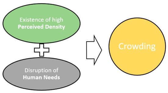
Figure 1.
Two conditions contributing to a sense of crowding. Source: Authors.
3.2. Streets as Open Space and Crowding
Urban open spaces, ranging from highly maintained gathering places to relatively natural landscapes, provide relief from noisy, busy, or overcrowded places and are closely associated with both perceived density and human needs. On the one hand, the human race has its origins in certain savannah landscapes that feature spreading trees, low ground cover, and water. “Nature then becomes a source of spiritual inspiration” as “viewing natural-looking settings can reduce stress and promote healing” [36] (p. 273). In comparison with the asphalt and concrete of built environments, people lean towards natural things because contact with nature is consistently found in association with positive psychological well-being, including attention restoration and stress reduction [37]. Additionally, it has been shown that “open space provides opportunities for specific kinds of behaviour and recreation, for privacy, for reducing perceived density…” [32] (p. 404). It is also found that increased visibility and a preferred view created by urban green/open space help to lower the perceived density and that a canopy of leaves and branches of street trees contributes to a moderation in the scale of wide streets and tall buildings [17].
Amelioration of perceived density with an increasingly urbanised and stressed population is, however, difficult. The growing demands for more housing and more open/green spaces result in a conflict between ‘denseness’ and ‘spaciousness’ because densification generally reduces spaciousness as floor area is added and open space is erased [38]. Furthermore, “designating land for park development often represents an unacceptable trade-off between scarce housing and park provision” [39] (p. 368). This conflict is evidenced by the fight between ‘dense’ and ‘green’ since the birth of modern town planning and its response to the ills of the 19th century industrial cities, where inner-city residents lived in crowded conditions without any access to natural environments. The obsessive pursuit of park-like built environments in Ebenezer Howard’s Garden City could also be seen in Le Corbusier’s Radiant City, which turned out to be “a park, skyscraper and automobile freeway version of Howard’s small-town Garden City” [5] (p. 342). Both efforts can be understood as trying to merge density and greenness with the concern that nothing is gained by overcrowding.
The key to creating a dense yet spacious city probably therefore lies in compactness, the quality of using very little space, and for that, the street has already proven its capability in keeping human settlements compact and spacious with a lively sense of community and interaction. For Jacobs [5], the streets of earlier eras were the major public open space (POS) of a city, with “its uses manifold and varied, far more than its modern analogue…” [40] (p. 1). Viewing streets as POS is very important in the development of compact cities, where an accepted balance and fine integration between built and open space is needed to create a dense but still spacious environment.
How does this work? In compact, dense environments, streets, by their very quantity, are simultaneously the major POS system and means of accessibility for connecting city inhabitants to both open spaces and other human needs within the built-up area and beyond. The sense of spaciousness in cities tends to increase along with the improvement of POS (quantity and quality) and through the enhancement of accessibility to places with higher spaciousness [41].
Therefore, streets have an important dual role of providing accessibility to properties and more distant POS and enhancing people’s immediate sense of spaciousness in their urban environments. However, this latter function can only be achieved if streets are designed in ways that allow them to serve other needs than just movement space and, therefore, to become a genuine part of the open space system in cities. For example, it is found that people in Spain preferred pathways to “stay places” indicating the need for a complex and diverse open space system to meet the demands of various population groups [42].
3.3. Examples of Streets as Open Space
The perception about a city is generally formed by its public open spaces, particularly its streets [43]. They give life to the city, creating its unique identity and providing space for human interactions to occur through a diversity of uses [44]. In this respect, Figure 2 depicts La Rambla in Barcelona, Spain, which beautifully serves the multiple roles of movement space for pedestrians, access to properties that front the street, a place to spend time and enjoy the colourful, green, and vibrant activities that line the street (Figure 3), and an unbroken pathway to the more distant spacious open spaces of the city’s waterfront (Figure 4). This multiple function of streets in serving open space, accessibility, and movement functions is further depicted in Barcelona through the integration of quality public transport and walking facilities and open space functions in a dense urban setting, even along a major arterial road (Figure 5).
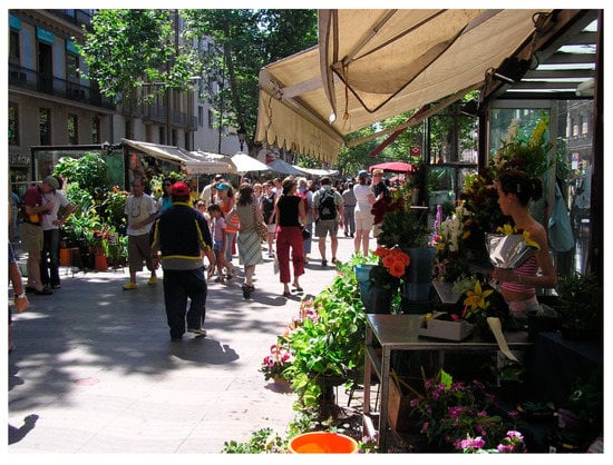
Figure 2.
La Rambla in Barcelona, serving accessibility, movement, meeting, and open space functions. Source: Jeffrey Kenworthy.
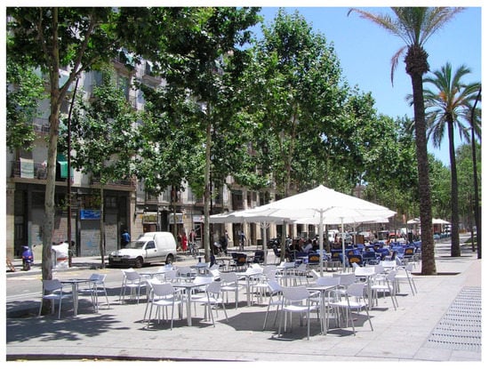
Figure 3.
Part of La Rambla showing the space provided for people to stay and enjoy. Source: Jeffrey Kenworthy.
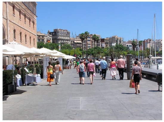
Figure 4.
Part of the Barcelona waterfront open space, accessible directly via a long walk down La Rambla. Source: Jeffrey Kenworthy.
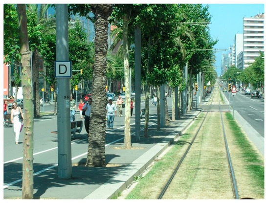
Figure 5.
A Barcelona street serving as a major pedestrian, public transport, and traffic thoroughfare and urban open space. Source: Jeffrey Kenworthy.
Looking at the city core of Barcelona (as shown in Figure 2, Figure 3, Figure 4 and Figure 5), New York, or Paris, green space is usually embedded within the street fabric, together creating an attractive, continuous spatial system for pedestrians to both move through and spend time in sedentary activities. This explains why dense European and American city centres that have relatively little POS (5–15%) but sufficient land allocated for streets (above 30%), are still well-liked by residents [45]. As Ståhle [41] (p. 233) puts it: “It all has to do with how public open spaces are designed and located within the street-pathway system in relation to where people live”. Using London as an example, Rogers [46] argues that for streets to function as POS they need to provide a diversity of uses stimulating the local economy, active facades allowing connections between the ground levels of the buildings and the pedestrians, human-scale constructions, green areas, shared space and safe circulation for all users, including public transport, and a specific identity that encourages social interactions.
There are many good examples of streets that reduce the negative perception about crowding in the city [47]; in fact, the opposite is true, since streets that are active and buzzing with activities make the city attractive. The section to follow examines traffic calming and self-building practices as preconditions for streets to act as POS and attract human interactions and social exchanges that make a vibrant city.
4. Preconditions for Streets to Be POS
Byrne and Sipe [48] (p. 17) explain that while “…most cities have a hierarchy of street types ranging from small alleys to large expressways…”, many of these “…could not be considered as green or open spaces as they are major traffic arteries” with few human activities at ground level. Indeed, most streets, which are so important in our daily life, have been reduced to ‘passages’ as opposed to ‘places’ [49,50]. The result has been a decline in the provision of quality outdoor public space and a reduced compactness, as witnessed in two major models of present urban expansion. The first is the horizontal suburban sprawl typical of auto-dependent cities, especially in North America and Australia, with densities that are too low and green areas that are dominated by the front and back yards of suburban homes. In such cities, there is much less in the way of public green open space and relatively few active and inviting other public environments (Figure 6). The other model is the high-density vertical ‘sprawl’ that is commonly seen in many Eastern and Middle Eastern cities and which is too often devoid of genuinely attractive and useable public open spaces with inviting human qualities (Figure 7). Both these models leave growing demands for high quality public open/green space unsatisfied. While moving along the streets, city dwellers consequently start perceiving more crowding than ever, such as jam-packed roads with cars bumper-to-bumper or city skies increasingly obscured by towering skyscrapers. Figure 8 and Figure 9 depict these issues in Dubai.
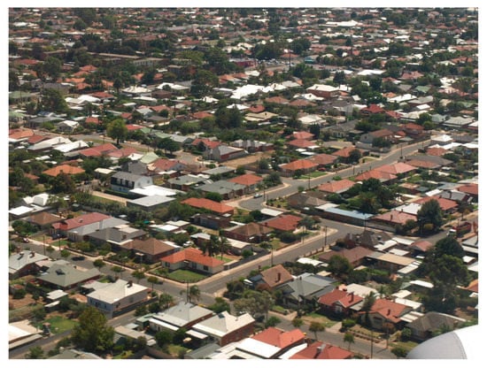
Figure 6.
Aerial view of Adelaide suburban areas showing the dominance of low-density sprawl with little public green or other public space and streets designed as movement space. Source: Jeffrey Kenworthy.
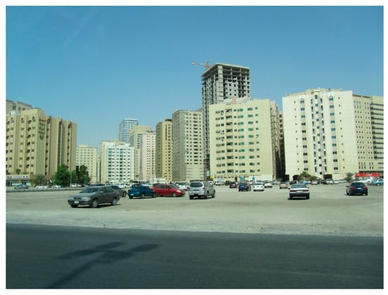
Figure 7.
High-density, auto-orientated vertical sprawl in Sharjah, UAE, devoid of quality public open space. Source: Jeffrey Kenworthy.
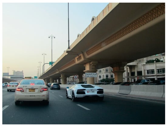
Figure 8.
Hostile, high-density, traffic-dominated public spaces in Dubai, UAE. Source: Jeffrey Kenworthy.
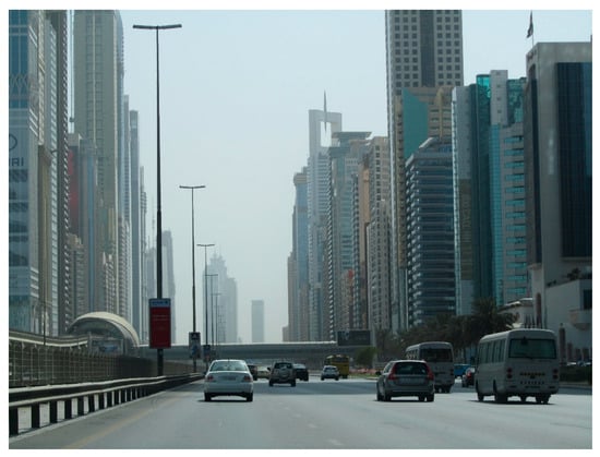
Figure 9.
Vertical density in Dubai, which increasingly creates a sense of crowding and limits visibility without any relief at ground level. Source: Jeffrey Kenworthy.
It is argued that a combination of traffic and building practices can greatly influence the way people perceive the street—be it crammed and polluted as a mere conduit for cars to drive through, or be it spacious and inviting as a POS for people to stay and enjoy. Initiatives such as traffic calming and tactical urbanism are thus gaining momentum for the revival of the street—the most common public space and the most readily available resource for relieving a sense of crowdedness in high-density environments.
4.1. Traffic Calming and Pedestrianisation
Traffic calming is a physical attempt to reduce traffic speeds to at least 30 km/h or less [51,52,53] along both arterial roads and on smaller streets in housing areas. Thereby, traffic is not eliminated as in the most extreme and most effective form of traffic calming, which is pedestrianisation. Traffic calming is achieved through changes in street design, which involve many different physical transformations. These include chicanes, mid-block neck-downs, altered horizontal and vertical geometry of the street, 45-degree or 90-degree angle parking, widened footpaths, and provision of cycle lanes and lane reduction (e.g., 6-lane to 4-lane, or 4-lane to 2-lane roads). Green entry statements into the street are also included, such as arches, changes in street surface and colour, signage to indicate pedestrian priority, planting of trees and introduction of gardens, and provision of street furniture or even spaces for games, to turn the street at least partly into a place, not just a passage. It can also include simple changes such as the provision of pocket parks within a grid-street structure where just one short block is turned into a small park for local use, which has the effect of slowing down cars along long stretches of straight streets. Newman and Kenworthy [15] provide a fuller picture of traffic calming. Figure 10 shows an example of effective traffic calming in Frankfurt am Main, Germany along Leipzigerstrasse.
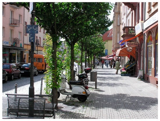
Figure 10.
Traffic calming along Leipzigerstrasse in Frankfurt am Main, Germany. Source: Jeffrey Kenworthy.
Pedestrianisation, which is increasingly practiced in the centres and sub-centres of cities today and sometimes across extensive street networks (e.g., Munich, Germany), as opposed to the single traditional “pedestrian mall”, is the most effective way of asserting the liveability needs of people in cities, especially in high-density areas. Figure 11 and Figure 12 show part of the pedestrian network in Munich and a green, pedestrianised sub-centre in Munich on the U-Bahn (metro) line 4 (Arabella Park). Pedestrianisation can also be practiced in more suburban areas, for example in small neighbourhood centres, by simply removing traffic for a block or two. This creates an enhanced sense of liveability, reducing the feeling of being crowded, and offers the opportunity to mingle in public space. The inner city of Montreal provides examples of this approach (Figure 13).
Figure 11.
Pedestrianisation in the city centre of Munich, Germany. Source: Jeffrey Kenworthy.
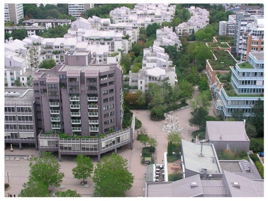
Figure 12.
The high-density Arabella Park subcentre in Munich built around traffic-free and greened urban space. Source: Jeffrey Kenworthy.
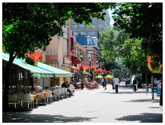
Figure 13.
Pedestrianisation in the high-density inner suburbs of Montreal. Source: Jeffrey Kenworthy.
In the absence of pedestrianisation, traffic calming is deemed as the first step for pedestrians to reclaim the right to the street—the right to host open-air markets, political rallies, and the ability to play games, stroll, busk, sit, read, and dine in an attractive street environment [54]. These activities and behaviours are most vulnerable to motor vehicles because “[o]nce traffic speeds exceed approximately 15 mph (24 km/h), roads become the monopoly of motorized traffic, effectively excluding other users such as pedestrians and cyclists” [55] (p. 709). There is a safety issue too, in that the faster the speed of cars, the higher the risk of pedestrian death in crashes, which rises from 5% at 20 mph (32 km/h) to 45% at 30 mph (48 km/h), and 85% at 40 mph (64 km/h) [56]. The general rule that the faster we travel, the greater the cost of this travel, also applies to other externalities such as air pollution, noise, and neighbourhood severance.
Moreover, the car is known for its insatiable appetite for space as well as for speed. As Gehl [57] (p. 9) explains: “A typical scene in many Asian cities is that all available city space is simply filled with moving and parked vehicles and every city got precisely as much traffic as space would allow”. Jane Jacobs recognised these problems 60 years ago when she said: “Traffic arteries, along with parking lots, gas stations and drive-ins, are powerful and insistent instruments of city destruction. To accommodate them, city streets are broken down into loose sprawls, incoherent and vacuous for anyone afoot” [5] (p. 338). Consequently, pedestrians, victims of the car, now find few other places except parks to go for a relatively carefree outdoor stroll. However, Jacobs [5] also saw a solution to these problems when she prefigured the invention of traffic calming, which gives back street space for uses other than accommodating cars. She prophetically said:
“Attrition of automobiles operates by making conditions less convenient for cars. Attrition as a steady, gradual process (something that does not now exist) would steadily decrease the numbers of persons using private automobiles in a city…What sort of tactics are suitable to a strategy of attrition of automobiles by cities? … Tactics are suitable which give room to other necessary and desired city uses that happen to be in competition with automobile traffic needs”.[5] (p. 363)
Smyth [58] estimates that “40 percent of the initial cost of development in conventional land use planning is automobile related” (in [32] p. 401), not to mention external costs caused by traffic pollution, injuries, and deaths. Considering the high cost mentioned above and the major safety issues in cities from speeding cars through residential streets, early traffic calming schemes such as the woonerf (“living yard”) in the Netherlands or more recently “home zones” in the UK, were introduced to slow down vehicle speeds in residential streets to walking pace in which pedestrians, bicyclists, and motorists coexist harmoniously by eliminating the division between pedestrian and auto space. In addition, these schemes frequently claim space from the vehicular domain for public use, such as parklets and small pedestrian plazas [59]. It has been estimated in the Netherlands that as of 2001, more than 7000 streets in residential areas had applied the woonerf concept, with pedestrians permitted to use the whole width of the street while having legal priority over cars [60]. Higher property values (10–15%) have also been witnessed in woonerf neighbourhoods, which suggest the popularity of traffic calming that reduces the negative impacts of cars on street environments [60]. Traffic calming schemes that reduce vehicular speeds have also made a difference in creating safer streets for vulnerable users and providing children with outdoor play areas close to the home.
Minimisation of the car’s negative effects, however, does not automatically lead to the maximisation of people’s enjoyment of street space. For example, traffic calming practices alone are not always sufficient for neighbours to get to know each other better because of the few meeting opportunities available in single-function residential streets [61]. Resulting from this lack of acquaintance in the neighbourhood, parents also cannot be absolutely assured that their children will be safeguarded through “eyes on the street”. Lowering car speeds is necessary but not enough for the street to automatically become an inviting place that brings closeness and security. Human interaction is inherently limited if residents still drive in and drive out of their streets. To get people out of their cars and into the street, reasons to travel by foot or bicycle are needed, and for that, urban planning policies and building practices play a pivotal role in providing for many daily needs at a local level. Higher densities and mixed land uses become critical, but how to achieve them often remains elusive.
4.2. Self-Building Practice
Coupled with traffic calming, appropriate building practices are potentially capable of transforming streets into vibrant public open spaces filled with various human activities. This is due to the contribution of buildings, which make life between them possible via the mixture of living, consumption, and production space along streets. While “streets are defined as roads with buildings on both sides” [62] (p. 1), it is the intimate relationship between housing and path that distinguishes a street from a road. Sadly, this close bond is now too frequently broken. Streets have too often become roads, or mere thoroughfares, and the housing, which frames wide streets, is for the first time divorced from the street with its ground floor and windows often insulated against road noise, air pollution, or burglary [63]. This is often attempted through the construction of high walls, which makes a walk down the street very unattractive and ensures no interaction between residents and passers-by.
Such a disconnect occurs partly because our road networks, as well as cities and neighbourhoods, are now designed for the car to comfortably travel through them with minimum interruptions. The loss of a wide variety of street front stores and other smaller local facilities means that instead of a short walk or bike ride along “slow streets” with a variety of activities lining them, many trips are now performed by car to big-box shopping centres or grand city parks. This perverse situation, where we find ourselves driving to a park for a walk and to a supermarket for groceries, leads to increasingly crowded roads, and impersonal recreational and shopping areas. In effect, our traffic problems derive from land use and building practices that separate different activities into single-use zones and degrade the traditional role of streets from places to passages to access dispersed daily needs [64].
As important as buildings are for the activities they accommodate, it is equally essential to consider how they are combined with the street. Being the most critical urban tissue or interstitial space in metropolitan areas, the street epitomises and shares with the city itself the same problems; both are now a collection of giant fragments rather than a unified whole, as they used to be. Due to single-use zoning policy and the massive scale of building projects, modern cities are suffering from giantism, a symptom featuring huge transportation systems that are segregated for single travel modes, sprawled residential or industrial districts that are monotonous and dull, and immense commercial complexes that are scattered and out of reach on foot [65]. Jane Jacobs expressed it this way in The Death and Life of Great American Cities:
“…the problem is size of use rather than kind of use. On certain streets, any disproportionately large occupant of street front is visually a street disintegrator and desolator, although exactly the same kinds of uses, at small scale, do no harm and are indeed an asset”.[5] (p. 234)
In comparison, organically grown cities are built upon the basis of daily activities over time and on a scale that is adapted to the senses and potential of human beings [57]. The antidote to this symptom probably lies in self-building practices that are embedded with traditional knowledge about scale and proportions and an understanding of the public culture of streets. Defined as building of a house by its owners [66], self-building can combine the work of amateurs as well as highly skilled professionals with the ideas and passion of those who will be the users. According to Brown [67], self-building is a creative process that results in architectural solutions that are unique and authentic and generates material (e.g., homes) as well as non-material (such as well-being and self-identity) outcomes.
After being abandoned in favour of big developers and large transformations instead of small ones, self-building practices that were very common before the twentieth century are now regaining popularity. Lloyd et al. [68] found that in the Netherlands and the UK, the share of self-build buildings in new housing areas, amounted to between 10–15% in 2015 (in [69]). The return of self-building practices not only provides a variety of lot sizes and housing types to cater for diverse housing needs [70], it also tends to create a walking fabric that accommodates more diversified functions and activities than does an automobile fabric [9]. This small-scale, fine-grain development creates a vibrant, human-scale street environment in which life, work, and leisure are so closely knitted that residents and tourists alike find it more convenient and efficient to walk than to drive.
Such a natural urban morphology can often be seen in many traditional towns and cities that grow upon “private ownership, incremental development, and organic adjustments among different households” [69] (p. 8). Figure 14 and Figure 15 demonstrate this in some of the chaotic, intensively mixed yet attractive and understandable streetscapes of Seoul, South Korea, while Figure 16 depicts this in Freiburg im Breisgau, Germany.
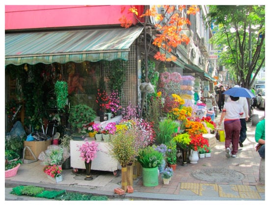
Figure 14.
Colourful, walkable, mixed use streetscape in Seoul involving self-building practices. Source: Jeffrey Kenworthy.
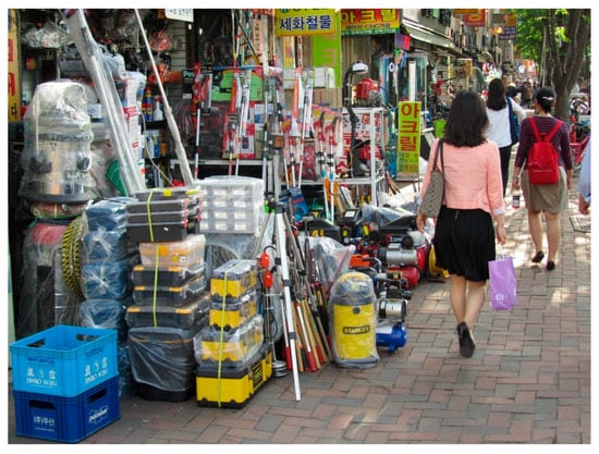
Figure 15.
Intensely mixed, pedestrian-accessible uses spilling out onto the footpath making the street both lively and legible. Source: Jeffrey Kenworthy.
Figure 16.
Freiburg im Breisgau, Germany, as an organically evolved, old urban landscape. Source: Jeffrey Kenworthy.
In order to understand how streets as POS make cities more liveable, it is important to also recognise the factors that contribute towards the perception of crowding. Being a subjective feeling and experience, the presence or absence of crowding can be influenced by the way the streets are designed. We refer to this as tactical urbanism and the section to follow elaborates on these concepts.
5. Mechanisms behind Crowding
The two main aspects of crowding are how urban density is perceived and what human needs are (see Figure 1). It is important to understand both in order to make a judgement about city density.
5.1. Perceived Density
For crowding to occur, a high perceived density must be present, either out of sheer lack of space or because of excessive social interactions or stimulus overload. For example, crowded indoor living conditions that arise from the perception of high dwelling densities, are often characterised by a shortage of space/rooms, an excess of human interactions/stimulation, and a resultant decreased control of privacy, rather than dwelling density per se. Like cramped interior environments, messy built forms can also generate feelings of crowding.
Owing to unbridled horizontal and vertical expansion, some modern cities are often compared to concrete jungles, featuring a clutter of tall buildings and structures, labyrinth-like circulation systems, and insufficient natural ventilation (Figure 17). This type of crowdedness comes from individuals’ negative impressions of the built environment, since “tall buildings, limited spacing and complex layouts increase the perception of density significantly” [17]. Therefore, Churchman provided a list of design variables such as small neighbourhoods, greater spacing, and separated building entrances, in order to form a low-density impression [32]. Nevertheless, some caution is required, as wider spacing has been frequently seen between taller buildings, indicating that the high-rise apartment does not necessarily mean high building density because of extended spacing and lower site coverage. In this respect, advocating low- to medium-rise, high-density residential development is probably a suitable middle ground, as it has good privacy with individual entrances.
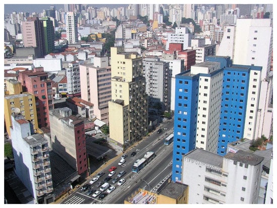
Figure 17.
The City of Saõ Paulo’s concrete jungle-like urban landscape. Source: Jeffrey Kenworthy.
This lower-rise, high-density urban landscape requires less spacing between buildings, which helps to diminish perceived density. If streets are also functioning as public open space with a balance of pedestrian and traffic needs, then the sense of crowding is strongly ameliorated (Figure 18 and Figure 19).
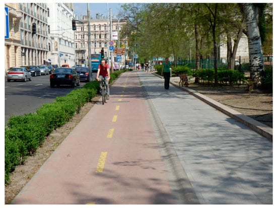
Figure 18.
A medium rise, dense urban landscape in Budapest ameliorated by generous pedestrian and cycling space and good landscaping. Source: Jeffrey Kenworthy.
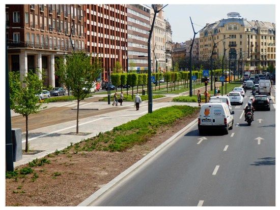
Figure 19.
A traffic calmed, medium-rise dense neighbourhood in Budapest where the street serves to reduce a sense of crowding and adds liveability, as well as a tram service in the middle of the road. Source: Jeffrey Kenworthy.
Gridlock is another typical example of crowding that is associated with the perception of high (vehicle) density and lack of space, both for vehicles and people. Considering that a root cause of a traffic jam lies in the separation of different land uses that requires cars to access dispersed daily needs, such as working and shopping, traffic alleviation cannot be achieved by mere increases in road supply [71] or by only reducing the number of cars via vehicle use restrictions. As Jacobs [5] (p. 348–349) puts it: “in the absence of city diversity, people in large settlements are probably better off in cars than on foot”. To create diversity and overcome automobile dependence, local streets ought to be an inviting destination, having a better jobs-housing balance, and a vibrant street life to diminish both commuting and non-work motorised traffic. Moreover, according to the theory of stimulus overload, a surfeit of stimulation such as petrol fumes or vehicle noise arising from road congestion leads to a perception of high density and such high concentrations of pollution are most likely to be evaluated as uncontrollable and unwanted, which results in negative perceptions of crowding [3].
Considering the unpopularity of automobile traffic, the Great Streets Initiative in Los Angeles set up the “People St” website allowing local communities and residents to apply for parklets, pedestrian plazas, and bicycle corrals [72]. Churchman [32] (p. 407) concludes that “converting a significant proportion of the spatial resources consumed by the car to other land uses may increase the positive effects of high density and reduce the negative effects”.
In brief, problems of perceived density lie in a combination of planning rules that leave self-building practice endangered, large-scale projects spinning out of control, modern transport codes that claim streets primarily for the car and practices that render the street a place that is noisy, polluted, and dangerous. The street as a special POS aided by traffic calming, quality public transport, and self-building practice constitutes a unique mechanism in dealing with the sense of crowding that is caused by perceived high densities. Undoubtedly, to achieve such qualities there must be an overhaul of current urban policies favouring vehicular traffic, single-use zoning, and large land holdings, all of which inevitably push up perceived physical densities and render cities more congested. Land-use zoning that strips the street of mixed uses, making daily needs for basic services and amenities out of reach on foot must be changed. These sought-after qualities can be aptly summarised by three images from Portland, Oregon’s downtown, where over many years, the city centre and surrounding neighbourhoods have transformed themselves into an area that is simultaneously dense, has quality public transport, attractive streetscapes designed for people, a strong residential population, green spaces, and streets that still carry a traffic function (Figure 20, Figure 21 and Figure 22).
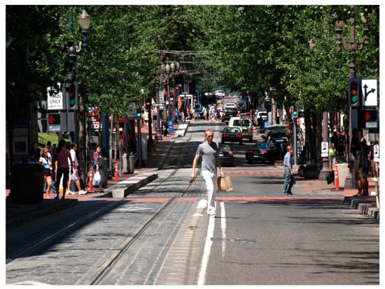
Figure 20.
A downtown Portland street showing a mixture of the Light Rail System (LRT) line, traffic lane, pedestrians, and greening of the environment. Source: Jeffrey Kenworthy.
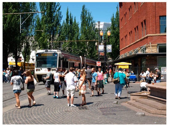
Figure 21.
Portland’s Light Rail System (LRT) system (MAX) on a street in a market area in downtown Portland that was to be for a freeway, but was transformed into a major public area. Source: Jeffrey Kenworthy.
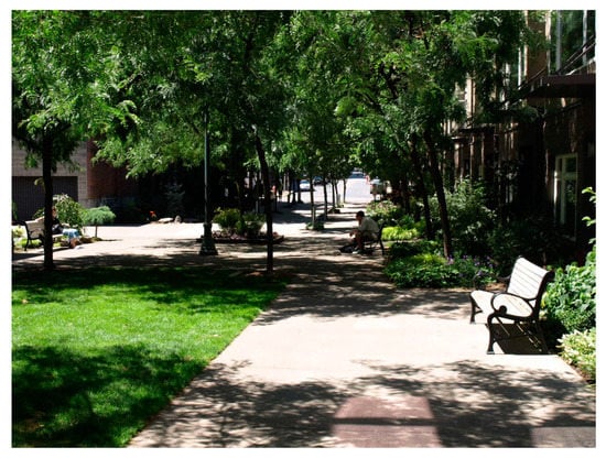
Figure 22.
A dense residential street in Portland’s Pearl District transformed into a green pocket park. Source: Jeffrey Kenworthy.
5.2. Human Needs and Tactical Urbanism
The existence of a high-density environment seems to be a necessary antecedent to the perception of crowding, but it does not necessarily and automatically produce a sense of crowding [73]. Only when individuals feel that their needs are disrupted by high densities, will they feel more stressed, attributing it to a negative experience of crowding [35]. Indisputably, basic physiological and social needs such as fresh air and personal safety are increasingly under threat, particularly in the outdoor street environment of cities. This is possibly linked with our overreactions to crowded conditions and an excessive quest for a “liveable” enclosed environment. Jacobs and Appleyard [65] (p. 117) state that:
“Too often, for example, the requirement of adequate sunlight has resulted in buildings and people inordinately far from each other, beyond what demonstrable need for light would dictate. Safety concerns have been the justifications for ever-wider streets and wide, sweeping curves rather than narrow ways and sharp corners. Buildings are removed from streets because of noise considerations when there might be other ways to deal with this concern”.
In time, modernist superblocks emerged “with garden and park-like settings giving the impression and benefits of lower densities” [33] (p. 342), trading off the access to jobs and services with the insatiable demand for sunlight and green space. By attempting to physically design out pollution and crime, this mono-functional planning resulted in a sense of private splendour and affluence in cities, but also a growing feeling of public squalor, reducing the street to a lifeless wasteland filled with petrol fumes and “ideally suited to rape, muggings, beatings, hold-ups and the like” [5] (p. 33). This can happen in what globally would be considered relatively low-density settings, such as Los Angeles (notwithstanding that the Los Angeles Urbanized Area is the densest in the USA—Newman and Kenworthy [7]). Mike Davis [74] in his book City of Quartz, talks graphically about Los Angeles, where the quality of public environments has been totally sacrificed in pursuit of a privatised, secure world through an almost complete capitulation to the automobile, and where streets are merely passages and a genuine civic life is almost non-existent. He refers to Los Angeles as displaying a “militarization of city life” resulting in an “ecology of fear” and ultimately, depicts the city as “Fortress LA” [74]. In addition to these matters concerning the public realm and how people are catered or not catered for, deeper psychological needs such as self-esteem and self-actualisation through personalisation and control of one’s dwelling are often ignored in many building activities.
Cities today, therefore, instead of being the cumulative expression of countless varied and conscious actions by many individuals, are too often the direct outcome of a single plan or design from a handful of professionals [75]. This is witnessed in the increasingly identical land-use patterns and built form across the world, whether that be unrelenting, monolithic high-rise urban fabric, or endless low-density sprawl as the two extremes. Moreover, the “control-density model” [32] (p. 404), suggests that densities that lead to less control over a situation may also be judged by those who experience them, as crowding. For example, while modern gated apartment compounds generally have an abundance of green space and good spacing of buildings, residents still can feel crowded because they are often not allowed to tinker with their dwelling, while also having little to do with, for example, the frequently rundown community facilities and broken elevators or the underutilised and boring collective green space. These factors are generally in the hands of property management which can often be found unforthcoming and unwilling to address the issues. Even when the community facilities are well maintained, residents rarely participate in the process and see it as an extra financial imposition rather than an opportunity to engage in communal activities.
Contrary to such “dead” anti-adaptive neighbourhoods (AANs), the residents of the now demolished notorious Walled City in Hong Kong showed a high degree of tolerance towards the extremely high density because the community was alive and was satisfying the changing needs of the residents during decades of building and rebuilding. It was the inhabitants who decided the community’s continuous development without any intervention from higher authorities or professionals, and “everything was agreed on an ad-hoc basis by those residents directly affected” [76] (p. 129). A similar situation can still be found in the Kampung Improvement Programme (KIP) in Surubaya, Indonesia, which has been very successful at regenerating what were once highly dilapidated, very dense physical living environments through an intense and largely self-funded process facilitated by participation between the local university of technology, the City of Surubaya, and the kampung communities themselves. The resulting dense but low-rise physical environment is very diverse, lively, green, and productive and functions within solely on non-motorised modes of transport [77]. Figure 23 and Figure 24 show the self-build nature of the urban environment and the absolute focus on living, green, lively, and walkable streets.
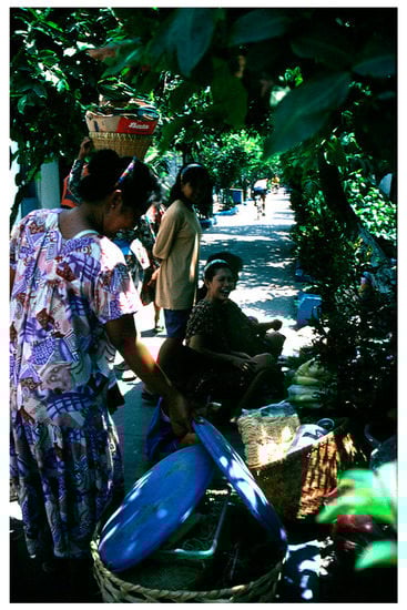
Figure 23.
A green, people-oriented street in a Kampung Improvement Programme (KIP) community in Surubaya, Indonesia. Source: Jeffrey Kenworthy.
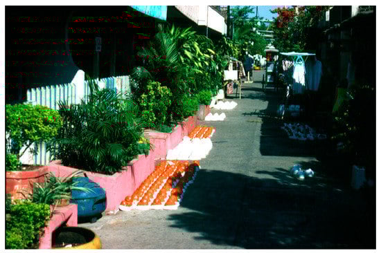
Figure 24.
Self-build houses in Surabaya, Indonesia with local cottage industries and streets that are both movement space and places. Source: Jeffrey Kenworthy.
Mono-functional, top-down, and hierarchical thinking of much city planning often ignores human needs and turns its back on the street. This results in the public being increasingly detached from the street, their own neighbours, and the community at large, leaving people little option other than to try to enjoy their own private, and from a wider city perspective, limited worlds [65,78]. Deprived of the right to self-building and the right to the street, an individual generally does not anymore see the primary environment as something to reshape according to their own wishes [79]. This is because building practices and streets have become a collection of fragments that fall largely in the hands of public agencies and licensed professionals. Instead of a place “where different, sometimes conflicting, lifestyles, interests and values are intermingled” [75] (p. 43), the primary environment has become a meaningless place, absent of diversity, spontaneity and surprise, and beyond the residents’ grasp. Sanford Ikeda [80] explains that: “substituting the genius of the planner for the collective genius of ordinary people diminishes the intricacy, complexity, of the social order” (in [69] p. 12). As a result, it appears that “the more a city promises for the individual, the less it seems to have a public life” [65] (p. 116).
The awareness of this problem has grown and has given rise to what is now termed tactical urbanism. According to the activist website ParCitypatory [81]:
“Tactical urbanism can be defined as ‘a city and citizen-led approach to neighbourhood building using short-term, low-cost, and scalable interventions intended to create long-term change’. Actions can be classified as tactical when they have a vision, a local context, a short-term commitment, a low-risk and high-reward value and the support of a community. Ideally, they even develop social capital by bringing neighbours together. In the long term, pop-up interventions are intended to get an official sanctioning or create change”.
This small-scale, quick fix generally targets undesirable physical conditions that fail the expectations of individual residents or community groups in two major respects—public spaces and housing. The most visible testing ground that showcases this bottom-up grassroots spirit is probably the street, a city’s largest reservoir of public space, and the land uses along it. Lydon and Garcia [82] (p. 6) summarise the opportunities as “empty storefronts, overly wide streets, highway underpasses, surface parking lots, and other underused public spaces”. Naturally, citizen-led interventions frequently take place in this immense laboratory in real time from “the rise of food trucks, pop-up stores, better block initiatives, chair bombing, parklets, shipping container markets, do-it-yourself (DIY) bike lanes, guerrilla gardens” [82] (p. 6). Figure 25 shows, for example, a recent example of a parklet in the East Perth Redevelopment in Perth, Western Australia.
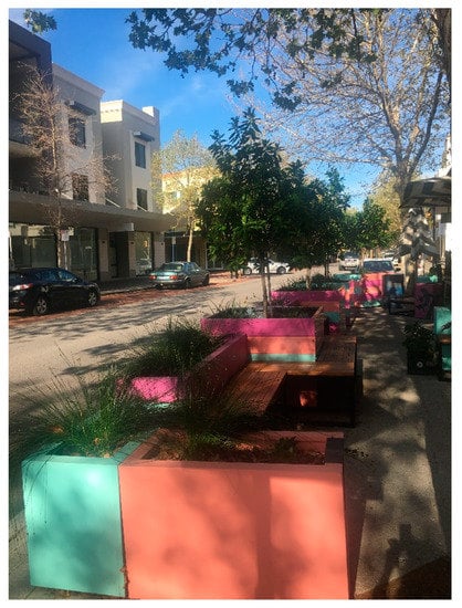
Figure 25.
Example of a parklet in the East Perth Redevelopment area in Perth, Western Australia. Source: Dora Marinova.
The annual Park(ing) Day is one of the most popular tactics employed to turn metered municipal parking spaces into small temporary “park” spaces for perhaps only 2 hours [83,84]. Similarly, intersection repair involves citizens converting street intersections into gathering places, which usually includes “not only the pavement surface but also the physical geometry to favour safety for all” [82] (p. 103). The Better Block project is another case that “works with commercial property owners and neighborhoods to create temporary, low-cost traffic calming and streetscaping experiments” [84] (p. 393).
These interventions, as with do-it-yourself (DIY) bike lanes, DIY Wayfinding, or guerrilla gardening on street medians, could be seen more as attempts to “hack” into an entrenched urban system, resisting the likes of car-centric urban planning [79]. This is different to the civic improvement in the nineteenth century, when “city plans were a relative novelty” [85] (p. 138) and major concerns were “for civic spirit, beauty, artfulness, order, and cleanliness” [85] (p. 139).
Community-led housing seems to be another promising area that grows in popularity for tactical intervention. The surge of community initiatives such as self-build or co-housing is a response to capital-intense, modernist approaches to mass housing production that leads to a wide gap “between what planning delivers and people’s needs” [86] (p. 1048). For instance, small-scale interventions like self-build activities manifest “the freedom of countless numbers of people to make and carry out countless plans…” [5] (p. 391). Rather than limited options to “choose between different types of lay-outs, kitchens, bathrooms etc.” in custom-build projects [87] (p. 32), the “many changes by many hands” approach [85] (p. 138) not only caters for diverse housing demands but also tries to address the issues of housing shortage and affordability. Wallace et al. (2013) made an estimation that 12,000 new self-build homes were produced in the UK annually (7.6% of new supply), “account[ing] for larger numbers of new homes than all of the large housebuilders produce together” [87] (p. 33). Meanwhile, the cost of owning a home could be substantially reduced not just by squeezing out the profit margin of big developers, but also by putting in cheap or free labour from locals or the homeowner, who may undertake all or part of the building works (in the USA, this is termed a “sweat equity” project).
Collectively built and self-managed, co-housing is another good example of the frustration with the current “alienated, isolated and disconnected social life in the city” [88] (p. 321–322). This small-scale style of housing cluster is for like-minded residents to seek neighbourliness that is not found in the mainstream housing market of multi-unit apartment buildings and gated communities in particular [89].
It could be said that either in the street space or housing sector, each and every tactical intervention mirrors an ignored human need to tinker with the built environment and walks around the barriers set up by the formal planning system, which often favours cars and large projects. For citizens, tactical urbanism, which “starts with something small and starts where it counts” [82] (p. 171) can be utilised to make some quick changes to the cracks of the increasingly faceless and characterless urban environment in an over-planned and over-regulated city.
The concern is the degree to which such small interventions of civil disobedience or informality will be tolerated by the authorities. In other words, is it possible to “set up formal planning provisions allowing residents to legally test tactical interventions…” [90] (p. 486), “leveraging small-scale change to build toward a larger, government-backed approach to urban improvement” like the City Beautiful movement did? [85] (p. 144). The section to follow discusses the required policy changes to create vibrant high-density cities where the streets function as open public spaces.
6. Policy Recommendations
In a bid to reduce perceived physical densities, direct planning interventions are required to integrate land use, landscape, architecture, and transport, reviving the street as a comprehensive POS. However, as crowding is perceived based on human needs, it is also pivotal to create the right conditions to encourage active citizenship and improve people’s well-being. This study puts forward the argument that designing streets as POS can reduce the perceived feeling of crowdedness in the city.
As our examples show, some cities around the world are already adopting such an approach. However, many are not. It is difficult to make generalisations across countries and different geographical and sociocultural settings. Even within the same city, appropriate planning interventions can help transform the streets from being traffic passages to places of activities. According to Whitelegg [91], where and when the economic paradigm dominates the way streets are viewed and used, traffic defined as movement of vehicles, is given priority. On the other hand, when public health, people’s experiences, reduced traffic risk, sustainability concerns, such as lower air pollution and greenhouse gas emissions, are prioritised, the streets can become urban spaces [91]. This can reduce the sense of crowdedness replacing it with people-friendly enjoyable and desirable urban environments where the use of the streets as public open space takes over.
China presents some examples of such change occurring. After a period of strong emphasis on the economic paradigm for developers with big blocks and wide roads offering diminishing opportunities for street shops and active mobility, a renaissance of the traditional urban fabric and street life is taking place in selected redevelopments, such as around Nanjing Honghua airport [92]. Ningbo city has also witnessed increased density from an average block of 15 hectares—typical for the automobile fabric surrounding the old city, back to the traditional two hectares in the Eastern New Town [93], allowing for higher density and energised street life.
Hence, for any positive change to build momentum, new planning interventions need to be supported by good conditions in the primary environments where residents spend most of their time, including the streets. Such interventions need to be integrated in the planning process. Furthermore, planning regulations should allow for self-building and people’s control over the environments where they live.
6.1. Integrated Planning Interventions
Firstly, city streets are better conceived as a green grid rather than mere black asphalt and modified accordingly. This would generate a higher green area/open space to floor area ratio and improve the accessibility of that open space. Such a green grid would not only offer some basic form of “nature” at people’s doorsteps—trees, vines, green walls, large flower pots, both on the ground and hanging from light-posts, vertical-window boxes etc.—but such a network would also provide comfortable access to gardens, parks, squares, and perhaps natural areas that often surround cities (e.g., Frankfurt’s Stadtwald—city forest, or its many community association gardens—Figure 26). Instead of constructing scattered parks to meet arbitrary standards such as 10% public open space in new subdivisions or 10 acres (4 ha) per 1000 residents [48], green streets effectively put the whole city in a “park”—an interconnected and evenly distributed new open/green system, which promises the public a more equal and immediate sense of contact with nature.
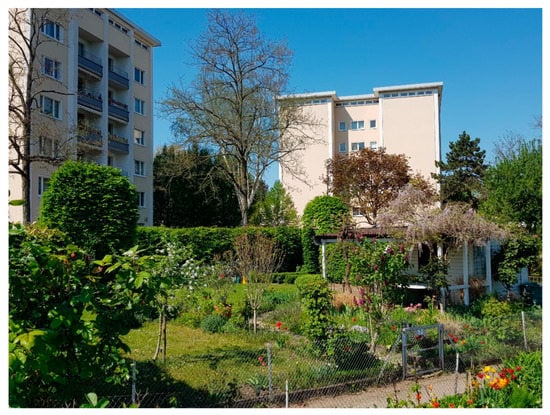
Figure 26.
Part of one of Frankfurt’s many local garden association areas in Sachsenhausen, 2 km from the Frankfurt Central Business District. The surrounding six and four-storey apartment buildings are arranged in a close-knit parkland setting. Source: Jeffrey Kenworthy.
Singapore is attempting to follow such a green vision for its entire metropolis through different forms of biophilic architecture where as many human-made structures as possible are given a green face, including building walls, support columns for transport infrastructure, and a general greening of streets. The basis for biophilic architecture is provided by Totaforti [94] and its application in Singapore is explained in detail by Newman [95].
This vision of green streets is a timely response to the changing needs of city dwellers that prefer more amenities and opportunities in streets than in parks during utilitarian walking [96]. It also calls for urban green to be generated “only if strictly necessary, avoiding dullness and waste” [69] (p. 27), and to be created for all, preventing green gentrification. This is because it is problematic knowing with certainty how much green is enough to justifiably satisfy various and varied needs in different parts of the city [42]. In this regard, it is necessary to challenge “the understanding of ‘green’ as only that which looks pretty or is somehow ‘natural’” [97] (p. 1039), because such an approach has been neglecting city streets as potential green networks often rendering present POS systems fragmented and underused. In other words, park systems in cities should be a perfect complement to, but not a replacement for the street system, in terms of the provision of POS and the creation of a sense of spaciousness. The UN Habitat [70] recommended standard is 30% of land and 18 km of street length per km2 in cities. This is a significant use of land to maintain accessibility and mobility, which under the scheme posited here, would achieve the dual purpose of also greening the city and enhancing a sense of spaciousness.
Secondly, streets as viewing corridors, would be better off framed by low- to medium-rise housing, without high-rise apartments obstructing strategic views and landmarks. To reduce a sense of crowding, it is desirable to leave city skies as open as possible. Tall or large buildings should be limited to clusters in the most suitable sites such as the central business district (CBD) and major activity centres that have higher infrastructure capacity. Additionally, given that high-rise buildings are not the only means to achieve dense living, it is advisable to ensure an adequate provision of small parcels in the land market to encourage small-scale, self-build, or collaborative housing. Executed in the right way, small housing and tall buildings can be a good combination to make the skylines neither too flat and dull nor too vertical and messy, contributing to the vital mix of great cities [98].
It is also essential to curb the proliferation of superblocks and buildings that are merely architectural edifices, turning their backs on the street without ground floor activities. Breaking the labyrinth and closeness that cut off inhabitants from the everyday life of the streets is critical. The massing, scale, and layout of all buildings should help make public street spaces coherent and at a human scale [99], avoiding free-standing individual buildings that are isolated by either large parking lots or ambiguous green area, without a positive contribution to street life. An abundance of short blocks and small plots should be in place to help support a great mixture of ordinary housing, amidst prudent use of exceptional buildings/superblocks, which in turn then contribute to a more open sky view and to revitalising broken, derelict street space.
Last but not the least, the street, underpinned by traffic calming, can serve as a diverse, multipurpose destination to encourage pedestrian traffic and to disincentivise car use. This is very different to the strict zoning, which was extensively applied in many cities across the world, especially in the post-World War II period, resulting in mono-functional streets, often characterised by lifeless urban space devoid of people. It is, therefore, vital for streets or districts to have more than one primary use and to reintroduce production, consumption, and leisure back to the street, balancing the desire to pass through the street (making it merely a conduit or passage), with the desire to go to the street (a place to stay) [45].
The creation of sufficient diversity enables residents to enjoy themselves by spending hours doing necessary errands and meeting many practical and social needs along the way without the need to drive [100]. This can also help translate into a vision of low-mobility and active lifestyles with a balance of city fabrics in mind, transforming more of the auto-city fabric into walking and transit fabrics, which help to support street life and the local economy [9]. While mobility, rather than accessibility, is still upheld as the key objective of transport planning [71], equating it with economic and social progress, a growing number of cities have come to realise the “penny-wise, pound-foolish” nature of merely maximising travel speed and minimising physical effort [101]. Without traffic calming, the diversity of the street alone is found insufficient to sustain a healthy and vibrant street life. High traffic speed is a major threat, which makes motorised traffic socially destructive, a fact that is convincingly described and measured by Appleyard [102] in his classic study of liveable streets in San Francisco. The dramatic reduction in personal autonomy of children playing on the street also well illustrates this point [96,103]. That is partly why a default speed limit of 30 km/h in built-up areas has been widely adopted in countries like the Netherlands and Germany [104,105]. The success of Times Square, New York in transforming a traffic thoroughfare to a pedestrian plaza provides further proof of helping local areas grow and thrive by reinstating the place function of streets [106]. In sum, diversity must join hands with traffic calming to bring back the widely-enjoyed hustle and bustle of street life, rather than the vehicular congestion disliked by most.
6.2. Control of Primary Environments
According to Reynolds [35] (p. 120): “Planning intervention directed only at controlling the density level is inadequate. It is the disruption of human needs that ultimately determines if crowding will occur”. It is, therefore, crucial to create the right conditions to encourage active citizenship in satisfying the very need for taking charge of one’s primary environment. This is where people spend most of their time and where crowding is believed to be more intense and difficult to address.
Taking control of one’s primary environment must start with one’s dwelling, enabling individuals’ right to housing, and the ability “to own, use, manage, transform private places” [107] (p. 57). The prevalence of anti-adaptive neighbourhoods (AANs—see earlier) indicates that individuals are losing the power to maintain and adapt their living environments not only because of public rules that freeze the adaptations of AANs, but also due to the daunting challenge of too many communal facilities and shared spaces to manage collectively [69]. To curb this trend requires the comeback of traditional building codes to encourage self-building practices for the possibility of personalised houses, or temporary and local usages. With distributed ownership and design, more tailored and personalised forms of development can be expected, not only satisfying individual households’ demands, but also “bypassing intermediate steps of real-estate development, marketing, promotion, and sales in an aim to restore financial sustainability” [108] (p. 308). On top of the individual right, it requires the collective right of community to govern themselves and organise activities to fully take charge of the primary environment.
When community facilities are in need of fixing or improving, the neighbourhood will very often “choose to do it themselves without asking permission” [79] (p. 6). When in situations of disinvestment, public inaction, and uneven development, the enthusiastic residents/creative class are likely to step in, helping the community build new communal space, create new business facilities, or take over local services. In time, this community-driven development may lead to the rise of an innovative district, which is “crowd sourced rather than close sourced, entrepreneurial rather than bureaucratic, networked rather than hierarchical” [109] (p. 25). Allowing a certain degree of autonomy and a substantial proportion of grassroots initiatives makes a community more creative and quicker to adapt to changing circumstances as the ‘Friends of the High Line’ organisation in New York City does in transforming a defunct railroad line into a popular linear park “to spur economic growth and structure the leisure and consumption patterns of the new urban middle class…” [110] (p. 9).
To be an alternative route to the top-down, plan-led development, a redistribution of power is unavoidable, as it does in the “Build your own home—the London way”, a UK programme that creates the conditions necessary for individual freedom and communal self-determination [99]. As Rosenfield [111] points out, “power shapes people’s perceptions of their ability to act on and influence the environment” (in [112] p. 255). The decentralisation of power firstly calls for a reduction of hierarchy in city governance to unlock significant untapped value in the wisdom of crowds. Underpinned by the Basic Autonomy Bylaw, the community bus initiative in Tokyo is a good case “whereby decision-making at the local government level is taken down the hierarchy to the lowest feasible level” [113] (p. 137). In addition, Berthelsen [114] discovered the existence of small places of anarchy, transforming the mega-size city of Tokyo into a human-scale one. Through human-scale action like DIY gardening, local residents feel rewarded with attachment to and care of their own environments, creating networks and bonds among those who care. Social bonds like this have been found to protect against stress and crowding in dense living environments [8], which further leads us to question whether we are building/planning for generations of living and collective memories or just for profit in anticipation of escalating property prices in the short term [63].
City governance further involves a clear demarcation between the public and private domain, with public planning focusing on delivering collectively significant public spaces and major infrastructure with public resources. On the other hand, a simplification of planning rules is desirable allowing DIY urbanism to take place in the private realm of the city. Admittedly, planning rules and procedures are increasingly complex and time-consuming, being dubbed as a brake on the economy [6] and being accused of either manipulation of powerless citizens, or alternatively, allowing citizen control of the planning process and its outcomes [115]. For both private investments and public participation, such “uncontrollable conditions weaken self-efficacy beliefs and undermine motivation resulting in learned helplessness” [116] (p. 390).
In comparison, principle-led planning that recognises self-organisation and encourages self-building, enables the expression of an uncountable number of life plans via daily building activities. Moroni and Cozzolino [75] (p. 44) point out that “[t]ypical examples are the common ‘organic’ morphological patterns that have emerged without rigid city plans, the hidden logic of the built environment or the different local building types”. In the case of Almere in the Netherlands, an innovative ‘organic area development’ is fundamentally led by a framework-rule that is simple and generic. It aims at “creating opportunities for incremental urban development that build upon a series of civic initiatives” [117] (p. 11), which avoid a paternalistic approach to city planning—“an end-state control device aiming at ordering the actions of private people…” [118] (p. 380–381).
Having the bottom-up autonomy and general framework-rules in place, local communities are enabled to transform the street, the backbone of the community, into a POS to experiment with new business ideas or life plans by adjusting building structure and function, streetscape or traffic conditions without top-down control. Such a POS may start to take form with civic initiatives like guerrilla and community gardening, street refurbishment or experimental traffic closures, through which residents become socially engaged to green and beautify the street and to calm the local traffic collectively. The “road-association” in the Netherlands is a good example where the many participants may share the costs, rights, and responsibilities of the road development, subsequent maintenance and spontaneous streetscaping. From traditional retail, to weekend open markets and to technology start-ups, this POS can be further diversified and vitalised through street users’ participation in localised business activities during which entrepreneurs and inhabitants become economically connected. For example, in Australia, in the Victoria Neighbourhood Renewal Programme, community-based enterprises were created via local networks “in horticulture, recycling, construction, hospitality, information technology and childcare” [119] (p. 116).
Additionally, seeing the streets as shared assets and as incubators of new ideas, the whole community may get fully motivated to brand the street/district, to upskill themselves, and to seek opportunities for local development, employment, and tax revenue. Given that these street experimentation spaces and networks are unique and cannot be copied, “the detailed outcomes of such a system cannot be determined in advance but rather ‘emerge’ from practices of adaptation and self-organisation.” [120] (p. 355). It is expected that such a synergistic relationship between people, firms, and place that is generated via street-level interactions may substantially enhance residents’ own sense of identity and boost their control of the primary environment.
7. Conclusions
The city is neither a farm nor a tree. To wrestle with crowding, it is essential to always keep in mind the balance of nature and city, creating adequate spaciousness without losing the concept of the city as an inherent concentration of people and activity and the advantages of urban living. In response to current fragmented and inefficient urban space, the concept of the city in the “park” reimagines the potential of urban streets, encouraging more compact developments created at street level and more urban green embedded in daily walking trips for utilitarian purposes. Seeing streets as the fundamental POS derives from the fact that cities have limited land resources and cannot afford the cost of filling in streets to build more parks. It is, therefore, very difficult to satisfy the varied and changing demands for a complex POS system and the need to reduce a sense of crowding in denser environments, without the unique contribution of a green, street-based grid. To help lower perceived physical densities, direct planning interventions are indispensable for a return of people-centred street space that is of a mixed use, human scale and green enough to satisfy people’s need for a better sense of spaciousness and contact with nature.
It is essential to realise the limitation of planned actions to ease a sense of crowding without considering human needs. Being an integral part of the primary environment, it is argued here that the street is the right means to deliver spaciousness as a comprehensive POS that is also open to citizen action and entrepreneurship. For that to happen, creating the right conditions to unleash pent-up creative energy in DIY or tactical urbanism is of paramount importance. This inevitably requires a restructuring of the state–civil society relationship and an introduction of more general, simplified planning rules. Through a redistribution of rights and duties, local inhabitants should ideally be the ones who take full charge of their primary environment and who truly have their say in local development, offering local solutions to local problems without the undue interference of bureaucracy or planning regulations that are too prescriptive.
The argument presented in this paper is based on autophotography and visual analysis of the street features, as well as integration of knowledge from a very wide range of literature on the subject from different disciplines. A quantitative assessment of the contributions of streets to alleviating the perception of urban crowdedness can be a topic for future research. Previous studies have quantified the impact of features, such as traffic calming and pedestrianisation on retail activities (e.g., Hass-Klau [121]) or benefits from active streets, which allow for walking, cycling, and public transport (e.g., Kott [49]), but a quantitative assessment of the impacts of streets as POS on people’s perception about crowdedness is yet to be conducted (e.g., through perception surveys). Such a perspective can potentially add to the evidence used in our study and expand the understanding of the streets as POS.
Drawing on traditional urban codes, seen especially in traditional walking city urban fabrics, modern cities could have been built with a lower sense of crowdedness caused by oversized buildings, and with public spaces that are less burdened with vehicles and all the other paraphernalia that accompany overdependence on private motorised transport (large roads, parking, gas stations, auto sales and repair facilities, large roadside advertising etc.). Sadly, history shows that uncritically embracing skyscrapers and cars, and discarding old ways of city building tend to produce both caged children and adults who are increasingly stuck in congested, machine-like cities. If we are to pursue high-density urbanisation, a core principle of sustainable development, there needs to be systematic consideration of how to mitigate a sense of crowding and to deliver a greater sense of green and contact with nature within the city. We argue here that to do this, there must be a renaissance of city streets, converting most of them into a comprehensive POS system and providing a framework for autonomous and spontaneous urban change, which avoids possible undesirable effects of high densities. Not until the orderliness and utility of big urban plans and the individuality and creativity of small interventions come together, can city residents begin to experience the fact that cities can be large, green, diverse, exciting, fulfilling, health-promoting, economically advantageous, and attractive places without a sense of crowding.
Author Contributions
Conceptualisation, L.W. and J.K.; formal analysis, L.W. and J.K.; investigation, L.W. and J.K.; methodology, L.W., J.K. and D.M.; project administration, J.K.; resources, L.W., J.K. and D.M.; supervision J.K. and D.M.; visualisation J.K. and D.M.; writing—original draft preparation, L.W., J.K. and D.M.; writing—review and editing, L.W., J.K. and D.M. All authors have read and agreed to the published version of the manuscript.
Funding
This research received no external funding.
Acknowledgments
The authors acknowledge the contribution of an Australian Government Research Training Program Scholarship in supporting this research.
Conflicts of Interest
The authors declare no conflict of interest.
References
- U.S. Census Bureau. Housing and Household Economic Statistics Division. In Historical Census of Housing Tables: Crowding; U.S. Census Bureau: Washington, DC, USA, 2011. [Google Scholar]
- Lepore, S. Crowding: Effects on Health and Behavior. In Encyclopedia of Human Behavior; Elsevier BV: Amsterdam, The Netherlands, 2012; pp. 638–643. [Google Scholar]
- Stokols, D. The Experience of Crowding in Primary and Secondary Environments. Environ. Behav. 1976, 8, 49–86. [Google Scholar] [CrossRef]
- Benedictus, L. Sick Cities: Why Urban Living can be Bad for Your Mental Health. The Guardian. Available online: https://www.theguardian.com/cities/2014/feb/25/city-stress-mental-health-rural-kind (accessed on 14 November 2019).
- Jacobs, J. The Death and Life of Great American Cities; Vintage Books: New York, NY, USA, 1992. [Google Scholar]
- Holman, N.; Mace, A.; Paccoud, A.; Sundaresan, J. Coordinating density; working through conviction, suspicion and pragmatism. Prog. Plan. 2015, 101, 1–38. [Google Scholar] [CrossRef]
- Newman, P.; Kenworthy, J. The End of Automobile Dependence: How Cities are Moving Away from Car-Based Planning; Island Press: Washington, DC, USA, 2015. [Google Scholar]
- Gray, A. Definitions of Crowding and the Effects of Crowding on Health: A literature Review. Available online: https://www.researchgate.net/profile/Noussa_El_Basha/publication/257440860_Association_of_vitamin_D_deficiency_with_severe_pneumonia_in_hospitalized_children_under_5_years/links/563116c008ae506cea676a49/Association-of-vitamin-D-deficiency-with-severe-pneumonia-in-hospitalized-children-under-5-years.pdf (accessed on 21 October 2020).
- Newman, P.; Kosonen, L.; Kenworthy, J. Theory of urban fabrics: Planning the walking, transit/public transport and automobile/motor car cities for reduced car dependency. Town Plan. Rev. 2016, 87, 429–458. [Google Scholar] [CrossRef]
- Güneralp, B.; Zhou, Y.; Ürge-Vorsatz, D.; Gupta, M.; Yu, S.; Patel, P.L.; Fragkias, M.; Li, X.; Seto, K.C. Global scenarios of urban density and its impacts on building energy use through 2050. Proc. Natl. Acad. Sci. 2017, 114, 8945–8950. [Google Scholar] [CrossRef]
- Angel, S.; Parent, J.; Civco, D.L.; Blei, A.M. The Persistent Decline in Urban Densities: Global and Historical Evidence of ‘Sprawl’; Lincoln Institute of Land Policy: Cambridge, MS, USA, 2010. [Google Scholar]
- Wolff, M.; Haase, D.; Haase, A. Compact or spread? A quantitative spatial model of urban areas in Europe since 1990. PLoS ONE 2018, 13, e0192326. [Google Scholar] [CrossRef]
- Kenworthy, J.R. Is Automobile Dependence in Emerging Cities an Irresistible Force? Perspectives from São Paulo, Taipei, Prague, Mumbai, Shanghai, Beijing, and Guangzhou. Sustainability 2017, 9, 1953. [Google Scholar] [CrossRef]
- Newman, P.W.G.; Kenworthy, J. Cities and Automobile Dependence: An International Sourcebook; Gower: Aldershot, UK, 1989. [Google Scholar]
- Newman, P.; Kenworthy, J. Sustainability and Cities: Overcoming Automobile Dependence; Island Press: Washington, DC, USA, 1999. Available online: books.google.com (accessed on 21 October 2020).
- Schiller, P.L.; Kenworthy, J.R. An Introduction to Sustainable Transportation. Policy, Planning and Implementation; Informa UK Limited: London, UK, 2017. [Google Scholar]
- Fisher-Gewirtzman, D. Perception of density by pedestrians on urban paths: An experiment in virtual reality. J. Urban Des. 2018, 23, 1–19. [Google Scholar] [CrossRef]
- Chapman, E.H.; Lynch, K. The Image of the City. J. Aesthet. Art Crit. 1962, 21, 91. [Google Scholar] [CrossRef]
- Oliveira, V. Urban Morphology: An Introduction to the Study of the Physical Form of Cities; Springer International Publishing: New York, NY, USA, 2016. [Google Scholar]
- Butz, D.; Cook, N. The Epistemological and Ethical Value of Autophotography for Mobilities Research in Transcultural Contexts. Stud. Soc. Justice 2018, 11, 238–274. [Google Scholar] [CrossRef]
- Guest, G.; Namey, E.E.; Mitchell, M.L. Collecting Qualitative Data: A Field Manual for Applied Research; SAGE Publications: Thousand Oaks, CA, USA, 2013. [Google Scholar]
- Fox-Turnbull, W. Autophotography: A Means of Stimulated Recall for Investigating Technology Education. In International Handbook of Primary Technology Education; Springer Science and Business Media LLC: Berlin, Germany, 2011; pp. 195–209. [Google Scholar]
- Thomas, M. Auto-Photography; Elsevier BV: Columbus, OH, USA, 2009; Available online: https://booksite.elsevier.com/brochures/hugy/SampleContent/Auto-photography.pdf (accessed on 28 September 2020).
- Glaw, X.; Inder, K.; Kable, A.; Hazelton, M. Visual Methodologies in Qualitative Research. Int. J. Qual. Methods 2017, 16, 1–8. [Google Scholar] [CrossRef]
- Steger, M.F.; Shim, Y.; Rush, B.R.; Brueske, L.A.; Shin, J.Y.; Merriman, L.A. The mind’s eye: A photographic method for understanding meaning in people’s lives. J. Posit. Psychol. 2013, 8, 530–542. [Google Scholar] [CrossRef]
- Elizabeth. Complete Guide to Street Photography for Beginners. Photography Life. Available online: https://photographylife.com/what-is-street-photography (accessed on 15 August 2020).
- Dovey, K.; Symons, F. Density without intensity and what to do about it: Reassembling public/private interfaces in Melbourne’s Southbank hinterland. Aust. Plan. 2013, 51, 34–46. [Google Scholar] [CrossRef]
- Sivam, A.; Karuppannan, S.; Davis, M.C. Stakeholders’ perception of residential density: A case study of Adelaide, Australia. Neth. J. Hous. Environ. Res. 2012, 27, 473–494. [Google Scholar] [CrossRef]
- Fleming, I.; Baum, A.; Weiss, L. Social Density and Perceived Control as Mediators of Crowding Stress in High-Density Residential Neighborhoods. J. Pers. Soc. Psych. 1987, 52, 899–906. [Google Scholar] [CrossRef]
- Busiol, D. A Review of Research on The Consequence of Living in a High-density City. Int. J. Child. Adolesc. Health 2016, 9, 443–453. [Google Scholar]
- Rapoport, A. Toward a Redefinition of Density. Environ. Behav. 1975, 7, 133–158. [Google Scholar] [CrossRef]
- Churchman, A. Disentangling the Concept of Density. J. Plan. Lit. 1999, 13, 389–411. [Google Scholar] [CrossRef]
- Forsyth, A. Congested Cities vs. Sprawl Makes You Fat: Unpacking the health effects of planning density. Town Plan. Rev. 2018, 89, 333–354. [Google Scholar]
- Sand, J. A Different Kind of Density: Lessons from Asian Megacities. Available online: https://www.planetizen.com/node/109691?utm_source=newswire&utm_medium=email&utm_campaign=news-06252020&mc_cid=3c1ccfb18a&mc_eid=b7628ea8fd (accessed on 26 June 2020).
- Reynolds, K.V.T. The Density-Crowding Relationship: Planning Implications for High Density. Available online: https://open.library.ubc.ca/cIRcle/collections/ubctheses/831/items/1.0096272 (accessed on 19 April 2019).
- Crewe, K.; Forsyth, A. Compactness and connection in environmental design: Insights from ecoburbs and ecocities for design with nature. Environ. Plan. B Plan. Des. 2011, 38, 267–288. [Google Scholar] [CrossRef]
- Chiang, Y.-C.; Li, D.; Bauer, N. Wild or tended nature? The effects of landscape location and vegetation density on physiological and psychological responses. Landsc. Urban Plan. 2017, 167, 72–83. [Google Scholar] [CrossRef]
- Arnberger, A. Urban Densification and Recreational Quality of Public Urban Green Spaces—A Viennese Case Study. Sustainability 2012, 4, 703–720. [Google Scholar] [CrossRef]
- Pincetl, S.; Gearin, E. The Reinvention of Public Green Space. Urban Geogr. 2005, 26, 365–384. [Google Scholar] [CrossRef]
- Laitinen, R.; Cohen, T. Cultural History of Early Modern Streets—An Introduction. J. Early Mod. Hist. 2008, 12, 195–204. [Google Scholar] [CrossRef]
- Ståhle, A. Compact Sprawl: Exploring Public Open Space and Contradictions in Urban Density. Available online: http://kth.diva-portal.org/smash/get/diva2:37326/FULLTEXT01.pdf (accessed on 10 September 2020).
- Maruani, T.; Amit-Cohen, I. Open space planning models: A review of approaches and methods. Landsc. Urban Plan. 2007, 81, 1–13. [Google Scholar] [CrossRef]
- Pacecho, P. Public Spaces: 10 Principles for Connecting People and the Streets. TheCityFix, World Resources Institute. Available online: https://thecityfix.com/blog/public-spaces-10-principles-for-connecting-people-and-the-streets-priscila-pacheco/ (accessed on 15 September 2020).
- Caccia, L. Urban Mobility: Public Policies and the Appropriation of Space in Brazilian Cities. Ph.D. Thesis, Federal University of Rio Grando do Sul, Rio Grande, Brazil, 2015. Available online: https://www.lume.ufrgs.br/handle/10183/133191 (accessed on 15 September 2020).
- UN Habitat. Streets as Public Spaces and Drivers of Urban Prosperity. Available online: www.unhabitat.org (accessed on 2 May 2019).
- Rogers, B. In Defence of the Realm: 10 principles for public space. Available online: https://www.centreforlondon.org/wp-content/uploads/2017/02/CFLJ5081_collection_essay_placemaking_0217_WEB.pdf (accessed on 15 September 2020).
- Roberts, J. Quality Streets: How Traditional Urban Centres Benefit from Traffic Calming. Transport and Environment Studies (TEST). World Transp. Pol. Prac. 1989, 26, 4–277. [Google Scholar]
- Byrne, J.; Sipe, N. Green and Open Space Planning for Urban Consolidation—A review of the literature and best practice. Urban Research Program. Available online: https://research-repository.griffith.edu.au/handle/10072/34502 (accessed on 4 April 2019).
- Kott, J. Streets of clay: Design and Assessment of Sustainable Urban and Suburban Streets. Ph.D. Thesis, Curtin University, Perth, Western Australia, 2011. [Google Scholar]
- Kott, J. A framework for research on pedestrian streets in America. J. Urb. Plan. Landsc. Environ. Design 2017, 2, 319–324. [Google Scholar]
- Hass-Klau, C. The Theory and Practice of Traffic Calming: Can Britain learn from the German Experience? Oxford University Press: Oxford, UK, 1990. [Google Scholar]
- Hass-Klau, C. The Pedestrian and City Traffic; Belhaven Press: London, UK, 1990. [Google Scholar]
- Hass-Klau, C. An Illustrated Guide to Traffic Calming: The Future Way of Managing Traffic; Friends of the Earth: London, UK, 1990. [Google Scholar]
- UN Habitat. Global Public Space Toolkit from Global Principles to Local Policies and Practice. Available online: www.unhabitat.org. (accessed on 8 April 2019).
- Nello-Deakin, S. Is there such a thing as a ‘fair’ distribution of road space? J. Urban Des. 2019, 24, 698–714. [Google Scholar] [CrossRef]
- Tranter, P.J. Speed Kills: The Complex Links Between Transport, Lack of Time and Urban Health. J. Hered. 2010, 87, 155–166. [Google Scholar] [CrossRef]
- Gehl, J. Cities for People; Island Press: Washington, DC, USA, 2010. [Google Scholar]
- Smyth, J. The Economic Power of Sustainable Development: Building the new American dream. In Sustainable Cities: Concepts and Strategies for Eco-City Development; Eco-Home Media: Los Angeles, CA, USA, 1992. [Google Scholar]
- Mehta, V.; Bosson, J.K. Revisiting Lively Streets: Social Interactions in Public Space. J. Plan. Educ. Res. 2018, 1–13. [Google Scholar] [CrossRef]
- Collarte, N. The American Woonerf: Creating Livable and Attractive Shared Streets. Available online: https://search-proquest-com.dbgw.lis.curtin.edu.au/docview/1508276677?pq-origsite=primo (accessed on 11 May 2019).
- Biddulph, M. Evaluating the English Home Zone Initiatives. J. Am. Plan. Assoc. 2010, 76, 199–218. [Google Scholar] [CrossRef]
- Özbayraktar, M.; Pekdemir, M.; Mırzaliyeva, G. Spatial Character Analysis of Streets as Public Spaces: The Case of Izmit Hurriyet and Cumhuriyet Street, Turkey; IOP Publishing: Bristol, UK, 2017; Volume 245, p. 072019. [Google Scholar]
- Macdonald, K.; Sanyal, B.; Silver, M.; Ng, M.K.; Head, P.; Williams, K.; Watson, V.; Campbell, H. Challenging theory: Changing practice: Critical perspectives on the past and potential of professional planning. Plan. Theory Pr. 2014, 15, 95–122. [Google Scholar] [CrossRef]
- Wen, L.; Kenworthy, J.; Guo, X.; Marinova, D. Solving Traffic Congestion through Street Renaissance: A Perspective from Dense Asian Cities. Urban Sci. 2019, 3, 18. [Google Scholar] [CrossRef]
- Jacobs, A.; Appleyard, D. Toward an Urban Design Manifesto. J. Am. Plan. Assoc. 1987, 53, 112–120. [Google Scholar] [CrossRef]
- Lexico. Self-Build. Oxford English and Spanish Dictionary, Thesaurus, and Spanish to English Translator. Available online: https://www.lexico.com/definition/self-build (accessed on 15 September 2020).
- Brown, R. Designing Differently: The Self-Build Home. J. Des. Hist. 2008, 21, 359–370. [Google Scholar] [CrossRef]
- Lloyd, G.; Peel, D.; Janssen-Jansen, L. Self-build in the UK and Netherlands: Mainstreaming self-development to address housing shortages? Urban, Plan. Transp. Res. 2014, 3, 19–31. [Google Scholar] [CrossRef][Green Version]
- Cozzolino, S. The (anti) adaptive neighbourhoods. Embracing complexity and distribution of design control in the ordinary built environment. Environ. Plan. B Urban Anal. City Sci. 2019, 47, 203–219. [Google Scholar] [CrossRef]
- UN Habitat. A New Strategy of Sustainable Neighborhood Planning: Five Principles. Available online: https://unhabitat.org/a-new-strategy-of-sustainable-neighbourhood-planning-five-principles (accessed on 8 April 2019).
- Kenworthy, J. Don’t shoot me I’m only the transport planner (apologies to Sir Elton John). World Transp. Pol. Pract. 2012, 18, 6–26. [Google Scholar]
- Zaki-Mustafa, P.E.; Birdsall, M. The Great Streets Movement. ITE J. 2014, 84, 27–32. [Google Scholar]
- Stokols, D. On the distinction between density and crowding: Some implications for future research. Psychol. Rev. 1972, 79, 275–277. [Google Scholar] [CrossRef] [PubMed]
- Davis, M. City of Quartz: Excavating the Future in Los Angeles; Verso: London, UK, 1990; p. 462. [Google Scholar]
- Moroni, S.; Cozzolino, S. Action and the City. Emergence, complexity, planning. Cities 2019, 90, 42–51. [Google Scholar] [CrossRef]
- Lambot, I. Self-Build and Change: Kowloon Walled City, Hong Kong. Arch. Des. 2017, 87, 122–129. [Google Scholar] [CrossRef]
- Kenworthy, J. Urban Ecology in Indonesia: The Kampung Improvement Programme (KIP); Murdoch University: Perth, Australia, 1997. [Google Scholar]
- Drucker, S.J.; Gumpert, G. The Impact of Digitalization on Social Interaction and Public Space. Open House Internat. 2012, 37, 92–99. [Google Scholar]
- Douglas, G.C.C. Do-It-Yourself Urban Design: The Social Practice of Informal “Improvement” Through Unauthorized Alteration. City Commun. 2013, 13, 5–25. [Google Scholar] [CrossRef]
- Ikeda, S. The City Cannot Be a Work of Art. Cosmos + Taxis 2017, 4, 79–86. [Google Scholar]
- PartiCitypatory. Tactical Urbanism: Creating Long-Term Change in Cities Through Short-Term Interventions. Available online: https://parcitypatory.org/2020/07/31/tactical-urbanism/ (accessed on 8 September 2020).
- Lydon, M.; Garcia, A. Tactical Urbanism; Island Press: Washington, DC, USA, 2015. [Google Scholar]
- Berg, N. The Official Guide to Tactical Urbanism. Available online: https://www.bloomberg.com/news/articles/2012-03-02/the-official-guide-to-tactical-urbanism (accessed on 13 August 2020).
- Finn, D. DIY urbanism: Implications for cities. J. Urban. Int. Res. Placemark. Urban Sustain. 2014, 7, 381–398. [Google Scholar] [CrossRef]
- Talen, E. Do-it-Yourself Urbansim: A history. J. Plan. Hist. 2015, 14, 135–148. [Google Scholar] [CrossRef]
- Silva, P. Tactical urbanism: Towards an evolutionary cities’ approach? Environ. Plan. B: Plan. Des. 2016, 43, 1040–1051. [Google Scholar] [CrossRef]
- Lang, R.; Mullins, D. Bringing Real Localism into Practice through Co-operative Governance: The role and prospects for community-led housing in England. University of Birmingham, Housing and Communities Research Group: Birmingham, UK. Available online: https://www.researchgate.net/publication/280013880 (accessed on 21 October 2020).
- Ruiu, M.L. Differences between Cohousing and Gated Communities. A Literature Review. Sociol. Inq. 2014, 84, 316–335. [Google Scholar] [CrossRef]
- Tummers, L. Understanding co-housing from a planning perspective: Why and how? Urban Res. Pr. 2015, 8, 64–78. [Google Scholar] [CrossRef]
- Wohl, S. Tactical urbanism as a means of testing relational processes in space: A complex systems perspective. Plan. Theory 2017, 17, 472–493. [Google Scholar] [CrossRef]
- Whitelegg, J. Economic inefficiency of the car-based paradigm. In Handbook of Sustainable Transport; Curtis, C., Ed.; Edward Elgar: Cheltenham, UK, 2020. [Google Scholar]
- Shao, R.; Duan, J.; Wang, L. Reconstruction of Street and Alley System for Life in Modern Cities. Planners 2016, 12, 91. [Google Scholar]
- Huang, W.; Ding, J.; Miu, D. The Evolution of the Size of City Street Blocks: A Case of Ningbo. In Proceedings of the China Urban Planning Annual Conference, Shenyang, China, 24–27 September 2016. [Google Scholar]
- Totaforti, S. Emerging Biophilic Urbanism: The Value of the Human–Nature Relationship in the Urban Space. Sustainability 2020, 12, 5487. [Google Scholar] [CrossRef]
- Newman, P. Biophilic urbanism: A case study on Singapore. Aust. Plan. 2013, 51, 47–65. [Google Scholar] [CrossRef]
- Thompson, C.W. Urban open space in the 21st century. Landsc. Urban Plan. 2002, 60, 59–72. [Google Scholar] [CrossRef]
- Curran, W.; Hamilton, T. Just green enough: Contesting environmental gentrification in Greenpoint, Brooklyn. Local Environ. 2012, 17, 1027–1042. [Google Scholar] [CrossRef]
- Florida, R. The Relationship Between Skyscrapers and Great Cities. Available online: https://www.citylab.com/design/2016/01/skyscrapers-cities-tall-buildings/431655/ (accessed on 14 November 2019).
- The London Plan, March 2016. Greater London Authority. Available online: https://www.london.gov.uk/what-we-do/planning/london-plan/current-london-plan (accessed on 10 September 2020).
- Gehl, J.; Svarre, B.B.; Risom, J. Cities for People. Plan. News 2011, 37, 6–8. [Google Scholar]
- Held, M.; Schindler, J.; Litman, T. Cycling and Active Mobility—Establishing a third pillar of transport policy. Available online: https://www.researchgate.net/publication/285199541_Cycling_and_active_mobility_-_establishing_a_third_pillar_of_transport_policy (accessed on 21 October 2020).
- Appleyard, D. Livable Streets; University of California Press: Berkeley, CA, USA, 1982. [Google Scholar]
- Kenworthy, J. Planning as if Children Mattered: A Case for Transforming Automobile Cities and Some Examples of Best Practice. World Transp. Pol. Pract. 2018, 24, 9–59. [Google Scholar]
- International Transport Forum (ITF). Speed and Crash Risk. Available online: https://www.itf-oecd.org/sites/default/files/docs/speed-crash-risk.pdf. (accessed on 20 November 2019).
- Whitelegg, J. Mobility: A New Urban. Design and Transport. Planning Philosophy for a Sustainable Future; Straw Barnes Press: Church Stretton, UK, 2016. [Google Scholar]
- Peterson, N. The Rise of the Pedestrian Plaza: Street-to-Plaza Conversions in the U.S. Available online: http://www.deeproot.com/blog/blog-entries/the-rise-of-the-pedestrian-plaza-street-to-plaza-conversions-in-the-u-s (accessed on 1 September 2019).
- Moroni, S.; Chiodelli, F. Public Spaces, Private Spaces, and the Right to the City. Int. J. E-Planning Res. 2014, 3, 51–65. [Google Scholar] [CrossRef]
- Savini, F.; Majoor, S.; Salet, W. Dilemmas of planning: Intervention, regulation, and investment. Plan. Theory 2014, 14, 296–315. [Google Scholar] [CrossRef]
- Katz, B.; Wagner, J. The Rise of Innovation Districts: A new geography of innovation in America. Metropolitan Policy Program at Brookings. Available online: https://www.brookings.edu/essay/rise-of-innovation-districts/ (accessed on 25 May 2020).
- Rianne, V.; Erwin, V. Co-production of Public Space: Policy translations from New York City to the Netherlands. Town Plan. Rev. 2016, 87, 139–158. [Google Scholar]
- Rosenfield, S. The Costs of Sharing: Wives’ Employment and Husbands’ Mental Health. J. Health Soc. Behav. 1992, 33, 213–225. [Google Scholar] [CrossRef] [PubMed]
- Regoeczi, W. Crowding in context: An examination of the differential responses of men and women to high-density living environments. J. Heal. Soc. Behav. 2008, 49, 254–268. [Google Scholar] [CrossRef] [PubMed]
- Khan, S.; Khan, M. Community Bus in Tokyo: Promoting Community Initiative through Decentralisation. Space Pol. 2012, 16, 129–151. [Google Scholar] [CrossRef]
- Berthelsen, C. Small Places of Anarchy in the City: Three Investigations in Tokyo. Available online: http://thisbigcity.net/small-places-of-anarchy-in-the-city-three-investigations-in-tokyo/ (accessed on 11 March 2019).
- Arnstein, S.R. A Ladder of Citizen Participation. J. Am. Inst. Plan. 1969, 35, 216–224. [Google Scholar] [CrossRef]
- Vaid, U.; Evans, G. Crowding. Encycl. Ment. Health 2016, 1, 388–392. [Google Scholar] [CrossRef]
- Rauws, W.S. Civic initiatives in urban development: Self-governance versus self-organisation in planning practice. Town Plan. Rev. 2016, 87, 339–361. [Google Scholar] [CrossRef]
- Alfasi, N. The coding turn in urban planning: Could it remedy the essential drawbacks of planning? Plan. Theory 2017, 17, 375–395. [Google Scholar] [CrossRef]
- Trivedi, N.; Khan, S. Community Participation in the Delivery of Infrastructure: A cross-cultural examination of its impact on the capacity building of local communities. In Proceedings of the Australian and New Zealand Association of Planning Schools Conference; Massey University, Palmerston North, New Zealand, 11–14 July 2014. [Google Scholar]
- Dovey, K. Informal urbanism and complex adaptive assemblage. Int. Dev. Plan. Rev. 2012, 34, 349–368. [Google Scholar] [CrossRef]
- Hass-Klau, C. Impact of pedestrianization and traffic calming on retailing: A review of the evidence from Germany and the UK. Transp. Pol. 1993, 1, 21–31. [Google Scholar] [CrossRef]


Publisher’s Note: MDPI stays neutral with regard to jurisdictional claims in published maps and institutional affiliations. |
© 2020 by the authors. Licensee MDPI, Basel, Switzerland. This article is an open access article distributed under the terms and conditions of the Creative Commons Attribution (CC BY) license (http://creativecommons.org/licenses/by/4.0/).