Abstract
The objectives of this exploratory paper are to propose and implement original urban design strategies, but also to highlight the links between cultural and natural heritage at the city–land–sea interface and, in particular, in coastal areas with historical value. For the moment, the tools for evaluating the social and economic “value” of this heritage are extremely limited. Moreover, design and environmental parameters may also come into play in this context, and it is worth considering the creation of an evaluation toolkit. The proposed methodology includes three phases: a documentary analysis, an on-site analysis consisting of a sensory mapping and an analysis by questionnaires. The main result of this work is to demonstrate that the methodology of sensory mapping techniques allows obtaining a holistic global approach where all human senses are considered in the analytical phase of pre-design of a coastal site, thus integrating this approach in a more sustainable design strategy. This methodology was evaluated in a significant natural and historic area. This case study and the literature review demonstrate that it is possible to provide a scheme toolkit that integrates all the parameters of importance identified in urban analysis, sensory mapping, environmental analysis and natural and cultural heritage analysis.
1. Introduction
This paper aims to present a holistic approach to the understanding and analysis of coastal areas rich in cultural and natural heritage elements. Mediterranean coastal cities are mostly urban environments with a long history, hence the idea that the different aspects that form the identity and perception of the cities can be interconnected in a framework that can be useful for further understanding and improvement. There is a need to consider multiple scales, national boundaries, the intersection of land and water and different stakeholders, policies and sectors [1]. The main aspects examined, called the three pillars of the study, are the different heritage values identified in each place, the aspects that make up the environmental characteristics and the formation of the urban form and the sensory perception of the users, i.e., visual, thermal, acoustic and olfactory, which are documented in different ways.
The understanding is summarized in Figure 1, which shows the relationships between the three pillars proposed for the analysis and recording of cities, namely heritage analysis, urban and environmental analysis and sensory mapping analysis. This classification allows the identification of a series of indicators to be used in the urban analysis. Step 1 includes the analysis of the cultural and natural capital of the site, step 2 includes the urban and environmental analysis, while step 3 focuses on the user’s perception through the sensory analysis.
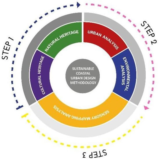
Figure 1.
Toolkit for pre-design indicators.
The scheme aims to propose a sequence of use of different analytical methods in order to include as many indicators as possible during the pre-design process. The synthesis of the above indicators formed a pre-design methodological scheme with replication value, which is useful for the study of similar sites in order to identify strengths and weaknesses as well as opportunities for the development of areas that meet sustainability goals and strategies.
The main contribution of this work is a qualitative methodological tool that can be used by all stakeholders in the design or redefinition of urban space. It is not a quantitative analysis but rather a qualitative process to be used as a checklist of all the parameters used in urban analysis and design.
The remainder of this paper is organized as follows. Section 2 presents recent related work considered in the literature review. Section 3 analyzes the materials and methods, beginning with a methodological overview and continuing with the presentation of the case study area selected for the analysis and formation of the preliminary design. Section 4 presents the main results of the analysis, and Section 5 is devoted to discussion. Finally, Section 6 synthesizes the main results of the study and presents the research perspectives.
2. Related Work
The city can represent an attack on the senses, and, by reducing our senses to the space around us, we approach the world from a very narrow perspective [2]. The sense of belonging also derives from the implications of the design of the environment, the activity that contains that environment and what those forms and activities mean to human beings [3,4]. Therefore, the human perception of a place develops on the basis of various stimuli, materials and intangible characteristics associated with these interactions.
The coastal zone is an interface between land and sea, composed of a continuum of coastal land, intertidal areas, aquatic systems including the network of rivers and estuaries, islands, transitional and intertidal areas, salt marshes, wetlands and beaches [5]. The European Commission also defines the coastal zone “as a strip of land and sea of variable width depending on the nature of the environment and management needs” [6]. It rarely corresponds to existing administrative or planning units. Natural coastal systems and areas where human activities involve the use of coastal resources may, therefore, extend well beyond the limit of territorial waters, and several kilometers inland [7]. Nearly half of the population of the European Union (EU) countries with a maritime border is located in coastal regions. Greece is the fourth country in the EU in terms of the length of its coastline [8].
These areas are important because the majority of the world’s population lives there. Coastal areas account for 20% of Earth’s surface but are home to over 50% of the total human population [9,10]. By 2025, coastal populations are expected to account for 75% of the total world population. In addition, more than 70% of the world’s megacities are located in coastal areas. Coastal areas are constantly changing due to the dynamic interaction between the oceans and land.
The literature review presented in this section focuses on three main areas: the link between natural and cultural heritage in places rich in these elements, aspects of environmental and urban analysis of the city and the perception of the city through the senses. This global analysis should make it possible to assert that the combination of these aspects can constitute a coherent and comprehensive approach to understanding, monitoring and redeveloping the urban design. Finally, this state of the art should make it possible to pose the main questions that will guide this research work. The results contained in this manuscript should help to answer them.
2.1. Natural and Cultural Heritage
Natural heritage and cultural heritage are key elements that characterize a city, region and place. The term “natural heritage” refers to all natural features, geological and morphological formations that provide habitats for natural species and plants, and natural sites of scientific, conservation or natural beauty value. The term “cultural heritage” refers to the history, legacy, cultural assets and attributes of a place inherited from the past. Cultural heritage is a concept that bridges the past and the future through the application of particular approaches in the present [11].
Natural heritage and cultural heritage have traditionally been considered as separate concepts, if not completely alien to each other. Indeed, it can be difficult to distinguish between nature and culture because, while culture contains only man-made aspects, nature can refer to anything that occurs naturally. In reality, heritage is a much more nuanced notion, in which the two notions are largely intertwined and interconnected. Europe’s natural and cultural heritages are now increasingly valued, not only for their intrinsic value but also for the significant contribution they can make to modern society and to the development of a more sustainable, equitable and environmentally friendly economy [12].
Early identification of the natural and heritage features of a place is the first step in the process and a very important milestone in the development of site strategies and sustainable visions. The issues are:
- Investing in infrastructure that supports the sustainable use of natural and cultural heritage assets.
- Developing strategies for the promotion and protection of natural and cultural heritage.
- Improving the quality of sustainable development opportunities based on the region’s heritage.
- Promoting the development of unique and distinctive natural and cultural heritage and related local resources.
- Developing long-term heritage projects.
Coastal and marine cultural heritage (CMCH) is under pressure, especially in tourist destinations, due to dynamic processes in coastal areas and human activities in the coastal environment [13]. In [14], the researchers conducted topographic and geometric surveys of archaeological, historical and ethnographic sites in large coastal environments. In [15], the authors analyzed all coastal and nearshore sites documented to date and presented in more detail and concluded that, in addition to remote sensing, a field assessment should be conducted before proposing new strategies. In [16], the researchers reported a lack of spatial legibility in historic districts. They applied qualitative and quantitative methods to analyze the spatial pattern of the selected areas. The results showed that, from the users’ point of view, landmarks and navigational markers were selected as the most significant elements affecting legibility. In [17], the authors created a digital inventory of historical and architectural heritage features, with the aim of promoting the past and present of industrial heritage buildings. “Minor” cultural heritage was studied in [18] through explanatory qualitative research, aiming to establish their role in the cultural heritage of less important monuments and sites.
There is a need to develop a broader and more dynamic framework for managing CMCH that recognizes the departure from traditional preservation methods and takes into account the complexity of the socio-political contexts of heritage [19].
2.2. Urban Design and Environmental Design
Urban and environmental analysis is one of the most important components of urban planning. It focuses on the organization and differentiation of the social, demographic and economic processes that help to shape cities.
The importance of urban and environmental analysis is imperative to truly understand the meaning of places and to create dynamic, distinctive and sustainable new spaces based on local aspirations and driven by a commitment to collaboration, participation and empowerment. The main benefits of a customized urban and environmental analysis can be summarized in eight points:
- Understand the local issues, opportunities, aspirations and physical characteristics of the study areas.
- Create a high-quality urban design strategy with a focus on placemaking, safety and community.
- Understand the social and economic context to create social value.
- Define a resident and stakeholder engagement strategy that is inclusive, authentic and focused on active local input into the design.
- Ensure a sustainable and innovative community identity through high-quality design.
- Create user-centered pathways that integrate with surrounding networks—creating a network of permeable streets and a series of unique public open spaces.
- Model and test ideas for a range of options to maximize site potential and optimize land use.
- Assist in the implementation of a rigorous viability testing mechanism as a “health check” during the research.
Sociology and environmental psychology have been recognized as valuable sources of information in the fields of urban design and planning to inform design decisions [20]. In addition to the physical characteristics of a place, it is essential to understand how places and their layout affect people. This discussion highlights the need for designers to read the relationships between environmental, sensory and social factors and has led to interdisciplinary concepts that could serve as a link between different perspectives [21].
The first important concept is the green–blue network, which can refer to landscape elements at different levels of spatial scale: from simple rows of trees to complete valley systems. Examples of green landscape elements are hedges, groves, bushes, orchards, parks, etc. Blue landscape elements are related to water. They can be ponds, puddles and pond systems, wadis, man-made buffer basins or streams. Together, they form the green and blue infrastructure.
The second important concept to describe is green infrastructure, which represents a “strategically planned network of natural and semi-natural spaces designed to provide a wide range of ecosystem services”. Therefore, a green network that is accessible to all is important for enabling people to socialize and for creating permeable and rigid environments that promote health and well-being. The Milton Keynes Development Corporation shows how these greenways are connected to formal and informal open spaces along river valleys and hill ridges [22].
Ecological corridors or connections between urban forests, gardens or other green spaces are recognized as a way to limit the negative effects of fragmentation. The creation of green spaces and corridors can be applied to most urban areas. Specifically, greenways are networks of land and especially elongated open spaces of varying widths that are connected to other paths and, along their length, to many [23].
From this point of view, the elements of the natural environment in urban models could also be modeled and managed as networks, merging the results of natural and social sciences in a multidisciplinary approach. Therefore, the increasing attention to the different roles that green spaces could play in the sustainable development of urban areas, as well as the networking theories applied in urban studies, have led the scientific community to include the concept of green network in its vocabulary [24,25].
2.3. Understanding the City through the Senses
All spaces are key elements of the urban fabric and our cities as they create patterns that encourage social interaction. They also create a sense of security as people can have a clear sense of where they belong. According to current guidelines, urban areas are essential for satisfying the need for social interaction, creating a sense of place, increasing awareness of the urban fabric and helping to improve the urban microclimate. In recent years, and particularly during the recent avian flu pandemic, architects, designers and planners have paid particular attention to the quality of public spaces and the built environment.
Local sensory mapping can play an important role in improving the quality of the urban landscape and help to find the elements needed to improve user comfort and experience. Recent research focuses on the influence of the structured environment on memories, behaviors and senses and demonstrates the importance of the environment, the spatial messages the user receives and how the user can perceive and experience the space [26].
2.3.1. The Sense of Belonging: Sensory Landscapes or Sensescapes
The significance of the perception of space is clearly stated here. One of the main subjective indices of the quality of the urban environment is the emotional sense of the city area, which contributes significantly to subjective well-being [27,28]. Urban life includes a variety of spatial and temporal activities that offer different levels of human interaction [29]. Human perception of place develops on the basis of various stimuli, both tangible and intangible, associated with these interactions. People are generally perceived as assets, as the essential resource. The focus is, therefore, on the sensory landscape of the city and its emotional and psychological impact [2]. In [30], participatory digital emotion mapping is proposed as an appropriate technique to collect public evaluations of the emotional state of urban areas.
The perception of space is described by the authors of [24] as an ability or tacit knowledge of the structural relationship between the sensory environment and the activity taking place in it. The senses play an essential role in decoding urban space and support the experience of the urban landscape and public space. Sensory experience is, therefore, the deep multi-sensory understanding of the environment and landscape around us through our visual, acoustic, olfactory, tactile and mental perceptions. This paves the way for the search for an optimal and multidimensional mapping of the urban landscape, through which users’ senses contribute to the understanding of the concept of space, uses and possible negative indications of dysfunction and design flaws. In [31], the authors investigated whether the way the structured environment is represented somehow influences our knowledge and feeling of that environment. The question at this point is whether our ability to represent a place is shaped by what we know about it and thus what we think about it.
Therefore, this research must not only understand how people experience space but also how their senses affect their understanding and connection to that space. The concept of “sense of place” thus becomes an important criterion for understanding the built environment to which we belong. Sense of place represents the connection to the place where we live. In [32], Falahat states that this general feeling that is created in an individual after a crisis and the perception of specific environments is called “sense of place” and refers to the emotional connections that people feel or develop in a place. Sense of place also derives from the effects of the design of the environment, the activity that takes place in it and what these forms and activities mean to people [33]. Cities, public spaces and the urban landscape in general can create this sense of place when people visit that space often and return because they have developed a sense of attachment and belonging in some way. This deeper connection to a public space makes it a place where people return and interact in a positive way. It is, therefore, important to move from public “space” to public “place”.
A sense of place creates a personal identity, allowing the city to become more important to users and society. This last point is also suggested by Adams, who notes that “to walk through a place is to become involved in that place with sight, hearing, touch, smell and even taste” [34]. The sensory landscape, also called urban sensescape [35], is the total experience of the city through all the senses, which also creates a sense of place for people, awakening memories, cultural connections and associations.
In [21], the authors studied “emotional reaction” as a construct of emotional experience using a ten-minute walking course. Walking experiences were also studied in [36]. The results showed that, in different spatial environments, the heat levels of the walkers were balanced between natural heat and light heat.
Sensory urbanism is an approach that explores people’s sensory experiences and understanding of their local environment. The rationale for this approach is the influential role of the senses in the development and influence of the experience of the urban environment. The assumption is that analyzing the urban environment through the senses will create more potential for the implementation of best practices in regeneration areas. A sensory city can include the needs and perceptions of people in the design of a network of public spaces. The city focuses on health, well-being and people, as well as the lived experience of cities, rather than infrastructure and buildings [35].
2.3.2. Sensory Mapping
Sensory mapping completes our understanding of the site and its experience through urban and environmental analysis and input from residents. The sensory maps are classified into visual maps, sound maps—soundscape, smell maps—scent landscape and tactile maps. The analysis through mapping of the different parameters related to the human senses has generated a more holistic approach that in turn will create a more comprehensive environmental strategy, including sustainable practices for each parameter that shapes the space and is related to the user’s comfort strategy. Visual maps are related to the parameters of visual comfort, namely preference for visual views and stimuli, appropriate lighting levels and elimination, where possible, of glare. Appropriate lighting levels should be defined [37,38], energy consumption should be minimized, light pollution should be avoided [39,40] and historic buildings should be lit accordingly to serve as landmarks [41,42,43]. Sound maps are digital maps that focus on the sound representation of a specific location. The term “soundscape” [29] refers to the sound environment of a specific location. It can also refer to real environments or abstract constructs, such as musical compositions and tape montages, especially when considered as an artificial environment. Sound research is also related to sound identity in the city and biocultural sound diversity [44]. Odor maps are developed based on the specific odors of cities that determine the relationship of people to their place of residence. The smell of a city can be a combination of street markets, restaurants and the types of food they offer, erosion of building materials, emissions from roads and transportation, waste odors and the smells of residents [45]. Texture maps are maps that identify the different materials and finishes that can be found in an urban environment. They can be related to thermal and visual comfort as well as embodied energy demand. These maps are directly related to the materials used in urban design [46].
The aforementioned mapping techniques will focus on recording man-made sounds, as well as documenting the specifics of the natural habitat, such as the sounds and smells of the sea, wind and seagulls, views of the horizon, etc. The selection of the specific area and the implementation of the sensory mapping occurred not only because of the richness of the place in heritage values but also because it is located in a residential area and because the coastal habitat activates the senses more intensely, i.e., intense light and reflections in the water, views, sounds of the sea and seabirds, smells of the sea and even the taste of salt brought to our faces by the wind.
Sensory mapping is being further studied as the most widely used method in combination with the various methods of urban analysis. It is believed that the combination of all the above methods and analysis techniques will provide a more holistic result in the form of a multi-indicator-based tool. In the following subsections, sensory mapping is briefly presented as well as the characteristics of the site in terms of the cultural and natural heritage elements that are present on the site and that distinguish it. In addition, this site was chosen because it is not only rich in such elements but also located in a residential area, which places people in a central position in this discussion focused on the relationship between humans and the tangible and intangible environment (see Figure 2).
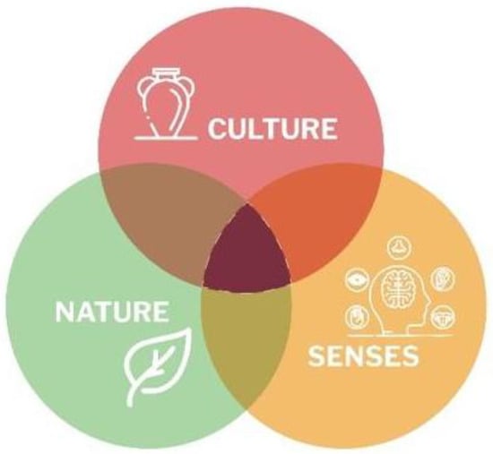
Figure 2.
Conceptual relationships between heritage and human experience.
Taking into account the three pillars mentioned above, we will seek to define the appropriate attributes that together can shape future cities and consider the heritage, urban and environmental characteristics of a place as well as sensory mapping as a key parameter to develop a land use model.
2.4. Research Questions Raised
This work is guided by the following three research questions (RQ):
- RQ1
- The first question concerns the possibility of linking the three main pillars of legibility and understanding of cities, as conceived in this research, namely heritage, environment and human perception. These three areas, briefly presented, can constitute a new method of studying these environments.
- RQ2
- The second question aims to determine whether the indicators of the three main pillars constitute a pre-design tool for stakeholders and decision makers to help them identify weaknesses and missing aspects when planning new projects or regenerating existing areas.
- RQ3
- The third question asks whether the first two pillars can be used at the educational level in the search for new methodological tools for teaching sustainable urbanism.
3. Materials and Methods
3.1. The Approach Implemented
As shown in Figure 3, the methodology followed involves four key steps. First, a literature review on a number of different topics occurs, such as the link between natural and cultural heritage, the meaning of coastal natural and cultural heritage (i.e., maritime cultural heritage), the “sense of place” in a city and, finally, sensory mapping techniques. This context highlighted the potential for understanding the city through the systematic recording of different sustainable design parameters and other methods related to the human sensory experience of the urban realm. In the second step, the research objective was identified and the research questions are addressed. In the third step, the results of the review are implemented in a coastal case study area of the city of Piraeus. Finally, based on the analysis of the case study, a pre-design proposal is presented, followed by recommendations and a sustainable design toolkit, mainly based on the coastal heritage.
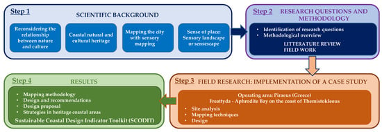
Figure 3.
Diagram illustrating the four key steps of the methodology implemented.
3.2. The Case Study Area, Mapping of Natural and Cultural Features
The case study area is located in Piraeus, the port of Athens (Greece), specifically in the coastal area of Freattyda, the Bay of Aphrodite, on the coast of Themistokleous. The site is rich in cultural and physical elements related to local heritage and vernacular culture; therefore, it was chosen as a case study to examine the methodology of different mapping techniques previously analyzed as a means to achieve sustainable outdoor space strategies. Piraiki is the southwestern coastal neighborhood of Piraeus, located east of the central port of Piraeus.
As far as the material elements of the cultural heritage are concerned, the first and most important is the archaeological monument of the ancient wall, called the Long Walls, which protected the port of Piraeus and connected it to the city of Athens [47,48]. In ancient times, Piraeus was called “Akti” by the Athenians and was famous for its rich mines. The locally produced “Aktitis stone” was used as building material in the Long Walls and in all the port structures of ancient Piraeus. Because of its rocky morphology, the site could not be used for the construction of coves for ships. Themistocles, therefore, built walls along the rocky coastline to protect the local population from waves and potential enemies. The walls of the coast (today Piraeus) were part of the set of long walls built at the same time by Themistocles to protect the road connecting the main agglomeration of ancient Athens to its two ports (Piraeus and Faliro).
The walls were built in several phases, starting in the middle of the 5th century before Christ (BC), and were about 6 km long [47]. The walls were destroyed by the Spartans in 403 BC after the defeat of Athens in the Peloponnesian War, and then rebuilt with Persian help during the Corinthian War in 395–391 BC. The Long Walls were an important element of Athenian military strategy as they provided a constant link between the city and the sea and also blocked sieges conducted by land (see Figure 4).
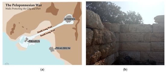
Figure 4.
(a) Map of the Long Walls; (b) the ruins of the walls today on the site.
The Long Walls shared similar basic features over four major construction phases spanning more than a century and a half. Below ground level, stone foundations were formed and curtain walls were pierced with gates and complemented by towers, while stairways provided access to walkways protected by parapets. Shortly before the use of long walls became superfluous in the early Hellenistic period, the Athenians began to install roofs on the wall walks [47]. Today, on the rocky shores of Piraeus, parts of Themistocles’ walls, about two meters thick, are still visible and are in the study area. The area was then abandoned and remained deserted for many centuries until the 1960s, when it was once again populated.
The monument of the Unknown Sailor is a second important monument of the material cultural heritage of recent history. This monument is of great importance and illustrates the naval history of Greece, which goes back several thousand years. The monument was presented in 1969 and consisted of a large concrete cross 15 m high, on which rested a sculptural composition of Professor Lazaros Lameras, which represented the wave of the sea and five bronze seagulls that symbolized the five continents, while the overall study of the monument was prepared by the architect N. Fintikakis (see Figure 5). The seagull sculpture was unfortunately stolen and is no longer in place. The square serves as a place to sit since a rather large platform serves as the base of the cross.
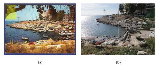
Figure 5.
(a) View of the harbor with fishing boats in 1970; (b) same view in 2020; in the background, the monument of the Unknown Sailor.
The fishing port is a third element of the region’s material and mobile cultural history. Traditional wooden fishing boats are an important part of the long naval history of the country, as mentioned above. In the small gulf is a fishermen’s association that serves the needs of the local community. The photos clearly show that, although there are currently fewer boats, the fishing activity remains the same (see Figure 5). Tangible and intangible maritime cultural heritage tells the story of the eternal relationship between people and marine and coastal environments. Maritime objects, historic ships, shipwrecks, bridges and maritime cultural landscapes also provide a sense of place and strengthen the cultural identity of communities connected to the sea [47].
An important part of Greek naval history are the “kaikia”, handcrafted wooden masterpieces that appeared in the Bronze Age and bear witness to the country’s long tradition and maritime heritage. Unfortunately, these works of art are now being destroyed due to the decision taken by the EU in 1983 [49,50] to subsidize fishermen to abandon their boats. The initial rationale for this questionable decision was to combat overfishing. Almost a decade later, in 1996, the EU asked fishermen to abandon their profession and destroy their boats. Hundreds of beautiful (and healthy) Greek boats ended up in landfills (see Figure 6). The EU spent at least EUR 46 million (in subsidies to fishermen) to demolish hundreds of decommissioned caiques and traditional fishing boats instead of financing the preservation and continuation of the maritime tradition not only of Greece but also of many other member states [51].
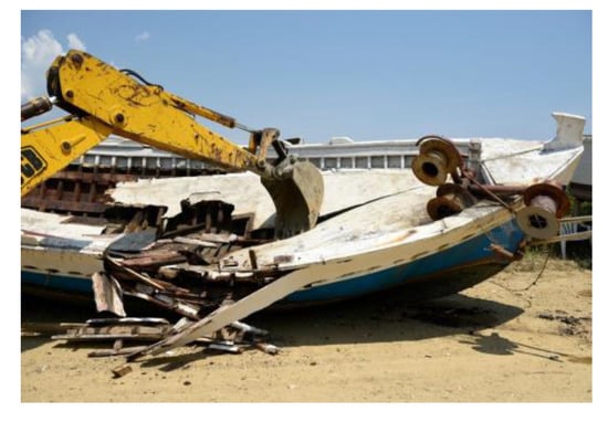
Figure 6.
Destruction of a traditional fishing boat (kaiki).
A fourth element of intangible cultural heritage is a Christian ceremony that takes place at this site, according to Greek tradition. Every year, during the celebration of the Epiphany (6 January), a priest, surrounded by brave young men and boys, throws a cross into the sea and the young men jump into the icy water to catch it. Whoever catches the cross is considered blessed for the whole year. In addition, this year, Greece celebrated the 200th anniversary of its independence, which resulted in a ceremony in which a Greek flag was flown on the waters of the Gulf specific (see Figure 7).
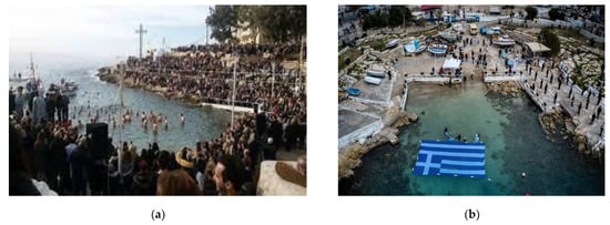
Figure 7.
(a) The celebration of the Epiphany; (b) the celebration of the 200th anniversary of the independence of Greece.
3.3. Field Research
Field research, also called on-site research, in the case study area was used to identify the various indicators needed in the pre-design phase of the coastal zone analysis and to eventually create a tool to facilitate this application. Various traditional analysis techniques were used, such as urban and environmental analysis (land use, solar and wind analysis, etc.) and Kevin Lynch’s methodology [52]. The results were not particularly informative despite the diverse preferences of users as to what new facilities they would like to have on the site. Nevertheless, they were undertaken and incorporated into the final outcome. In addition, participatory design was attempted through questionnaires to anonymous users of the site. The results were not particularly informative despite the diverse preferences of users as to what new facilities they would like to have on the site. For this reason, user perceptions are only briefly presented in Table 1.

Table 1.
Some perceptions of the participatory process with the local community.
It is clear from the above that the site is rich in cultural heritage elements, mainly related to the coastal location of the area. Therefore, the site could also be characterized as a maritime cultural heritage site (MCH). The land use analysis revealed that, beyond the residential use, which is the main one, the other uses are recreation and small business.
The area is also rich in natural habitats, such as rock formations, flora and fauna. Analysis of the site revealed the presence of more than 24 different plants that are documented in Appendix A. Most of them are endemic plants, mainly shrubs, which have to cope with strong, often salt-laden winds, harsh conditions and lack of water. Above all, coastal plants must be wind-, drought- and salt-resistant. In such a small area, it is impressive to see the number of species identified, which demonstrates once again the importance of biodiversity in the Greek territory. In addition, the obvious proximity of the natural environment to the sea creates opportunities for all kinds of coastal habitats, such as coastal moss and algae on rock formations. People also bathe in the sea, although the quality of the water is disputed. It is important to note the importance of restoring and protecting coastal habitats in coastal cities where the effects of urbanization have led to degradation of the natural environment. The next phase of the project is a field analysis, which led to the maps presented in the next section.
4. Main Results
The analysis of the area was undertaken by the student groups over the course of a day and consisted of three main thematic areas: urban and environmental analysis, cultural and natural heritage analysis and sensory mapping analysis. The urban analysis focused on Kevin Lynch’s methodology [52], land use analysis, pedestrian and vehicle movement analysis and environmental parameter analysis, including solar analysis, prevailing wind analysis and lighting analysis. Aspects of natural heritage, such as vegetation, were mapped in this phase of the analysis and are presented below for illustrative purposes, while other aspects, primarily cultural, were addressed in the literature review. The third area of the thematic analysis, the sensory approach, is presented in more detail, with a map for each sense. Figure 8, Figure 9, Figure 10 and Figure 11 show examples of the maps created. As shown in Figure 8a, the urban analysis showed a variety of potentials in terms of movement, possible new pedestrian routes closer to the waterfront, possible bike lanes, changing the width of streets to create wider pedestrian paths, etc. Lynch’s methodology also revealed a number of interesting landmarks in the study area. This is linked to the cultural heritage assessment carried out through observation, documentary analysis and discussion with the local community (see Figure 8b).
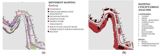
Figure 8.
Urban analysis: (a) urban analysis map of pedestrian and vehicle movements; (b) Lynch’s urban analysis map by landmarks and edges.
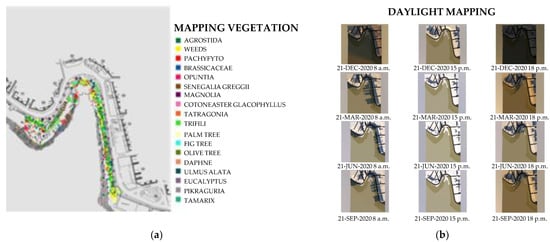
Figure 9.
Natural habitat analysis: (a) mapping of existing vegetation; (b) sunlight study of the case study area.
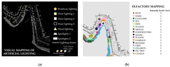
Figure 10.
Sensory analysis: (a) visual mapping of artificial lighting; (b) olfactory mapping of existing odor types recorded and their level of intensity.
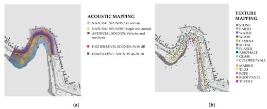
Figure 11.
Sensory analysis: (a) mapping of existing sounds; (b) mapping of existing textures.
The natural habitat was assessed in a variety of ways; a vegetation map is presented here and, as noted earlier, a large number of species were identified, demonstrating the extent of biodiversity in the area (see Figure 9a). A solar study is also presented, which is part of the environmental analysis of the site and shows possible locations for seating and other uses (see Figure 9b).
The sensory analysis consisted of a series of maps illustrating different aspects of sensory monitoring. The visual maps focused on natural and artificial lighting levels, as well as fixture types, preferred views and glare. As an example, we show the artificial lighting of the area at night (see Figure 10a). As far as odors are concerned, a wide variety of different odors were identified, as well as a variety of intensities. The smell of the sea seems to dominate (see Figure 10b). For auditory perception, a series of acoustic maps were created to monitor the different types and levels of sound (see Figure 11a). Finally, touch was represented by documenting the different materials used on site. The variety is great and can be understood by feeling the texture during the visit or even while walking, as well as the different temperature of each material through the skin (see Figure 11b).
The results of the sensory tracking and mapping clearly show that this method provides a better understanding of the richness of the environment in places with high heritage value. After the urban and environmental analysis, sensory experience tracking provides a better understanding of places with complex entities and abundant stimuli. The user plays a central role in the analysis and, of course, in the synthesis process that may follow. It is an anthropocentric process, but one that takes all other aspects into account.
The methodology described above was applied for educational purposes to a group of students at the University of West Attica (Greece), School of Applied Sciences and Culture, Department of Interior Architecture. Students taking the undergraduate course “Sustainable Design II” presented a number of very interesting design proposals derived from the design methodology described above and aimed at the cultural and natural regeneration of the site by integrating an anthropocentric approach defined by sensory analysis and the synthesis of its results. The in-depth study of the site, the theoretical analysis of the heritage issues presented in the previous chapter, as well as the fieldwork regarding the public’s contribution and needs, allowed the formulation of an indicative design proposal for the site, in addition to, and more significantly, a methodological toolkit for indicators that can be used as a pre-design analysis tool for sites with similar characteristics.
The scientific background and site analysis led to a synthesis of the project, combining all the results. These results are key factors in developing the program, testing the methodology and implementing the concept of a design proposal. Sustainable strategies and proposed interventions include stormwater management, shading devices, renewable energy sources (RES), including primarily solar collectors and small urban wind turbines), smart urban equipment, green roofs, landscaping, use of sustainable materials, recycling, acoustical improvement interventions and others. As the presentation of the proposed design is not the main focus of this paper, only two maps are presented in the following figure, namely the proposed new functions, which are the result of the collaborative process (interviews, etc.) with local users as well as the urban analysis conducted by the class, and a final drawing of the area showing the new proposal (see Figure 12).
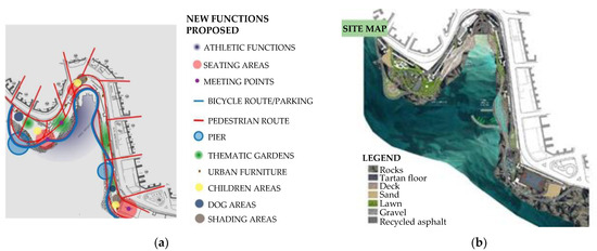
Figure 12.
(a) The proposed functions for the case study proposal; (b) the final case study design proposal with all implemented parameters.
5. Discussion
Natural resources have meanings, functions and management effects that are entirely cultural. Coastal areas are places of natural significance, often places of natural heritage; thus, the implementation of sustainable strategies is even more difficult there. They are places where the reconnection of natural and cultural capital is not only easy to achieve but is essential to maintaining biocultural diversity.
On the other hand, the regeneration of urban environments through environmental strategies should be a user-oriented solution. Sometimes, people are sidelined and the focus is on the built or natural environment without considering the needs and aspirations of people. Different mapping techniques can inform design in a more holistic way when, at the same time, the notion of comfort, understood as the spiritual, emotional and material needs of users, is the focus. Sensory maps, combined with comfort parameters, can be a very promising tool in the scientific field of comfort and mapping, enabling the creation of a sustainable urban “sensory landscape”. At this point, it should be noted that, by combining participatory design, an even more sophisticated collaborative sensory mapping methodology can be created. At the end of the analytical phase of the current research, a methodological tool presenting the design criteria involved in the sustainable regeneration of coastal urbanism, combining cultural and natural identity, is presented in the form of a diagram.
The analysis method, described in detail in the previous chapter, is based on three main areas: urban and environmental analysis, cultural and natural heritage analysis and sensory mapping. This classification allowed the identification of a series of indicators to be used in the urban analysis. The synthesis of the above-mentioned indicators has constituted a methodological tool with replication value, useful for the study of similar places. The specific indicators and parameters evaluated in the proposed method are presented in detail in Figure 13. These parameters can help stakeholders and designers to make decisions in similar projects.
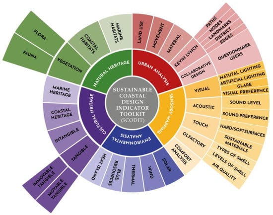
Figure 13.
The sustainable coastal design indicator toolkit (SCODIT) developed by the authors in places rich in cultural and natural heritage features.
The methodology deployed in this study has proven its effectiveness. Despite this, a major limitation is that the proposed tool, although aimed at actors from different backgrounds and scientific fields, does not provide a quantitative analysis but rather a qualitative process to be used as a checklist built on a set of rules of thumb.
6. Conclusions
The main objectives of this exploratory article are to propose and implement original strategies for coastal development with historical value by developing a series of indicators to be used but also by highlighting the links between cultural and natural heritage at the interface between city and sea. To achieve these objectives, the city of Piraeus (Greece) was chosen to develop a methodology for a sustainable and resilient design strategy. This last point is currently at the center of scientific discourse as resilience theory advances the discourse of urban sustainability in specific contexts by seeking to study how cities build the capacity (relying mainly on preparedness, adaptability and transformability) to respond to changing and disruptive situations. Strengthening urban resilience is essential for maintaining or restoring biocultural diversity, connectivity, multifunctionality and adaptive design.
The indicators we propose, summarized in a comprehensive toolkit called the Sustainable Coastal Design Indicator Toolkit (SCODIT), take into account the following pillars: urban analysis, sensory mapping, environmental analysis, cultural heritage and natural heritage. Among these key elements, “sensory mapping” has proven to be an appropriate and effective tool for accurately informing designers about how people experience natural and cultural interactions in these areas. This effectiveness was in fact assessed in the coastal zone, where intense sensory stimuli were recorded, mainly due to the sea and its visual, acoustic and olfactory presence on the site, as well as interactions between land and sea.
The methodology was tested with university students, who developed projects on real cases and sites, after applying the SCODIT concepts. The students responded to this challenge with numerous interdependent proposals, all very different from one another, even though they were based on the same SCODIT. As a result, SCODIT offers great freedom in decision making, as well as in concept formation.
All our experience leads us to conclude that reconnecting natural and cultural capital and maintaining biocultural and environmental diversity should be explicitly integrated into urban planning strategies, particularly at the land–sea interface.
Future work could involve a larger sample of people as well as a different methodology, such as an “urban game” that would facilitate interaction and hopefully yield more meaningful results. It should be noted that most of the questions raised by users are related to natural habitat and its potential improvement. Although relevant methodological tools have been developed, further research is certainly needed to determine if these tools can contribute to the adaptive design and monitoring of a sustainable and resilient design strategy.
Author Contributions
Conceptualization, M.S.; Data curation, M.S. and K.S.; Formal analysis, M.S.; Investigation, M.S.; Methodology, M.S. and K.S.; Project administration, M.S.; Resources, M.S., K.S., S.J. and Z.K.; Software, M.S. and K.S.; Supervision, M.S.; Validation, M.S. and K.S.; Visualization, K.S. and R.P.; Writing—original draft, M.S.; Writing—review and editing, M.S., S.J. and Z.K. All authors have read and agreed to the published version of the manuscript.
Funding
This research received no external funding.
Institutional Review Board Statement
This study involves the analysis of datasets obtained in previous research based on voluntary participation, where all data were properly anonymized. Consequently, the work presented here is unlikely to be prejudicial to all participants.
Informed Consent Statement
Informed consent was obtained from all study participants at the time of initial data collection.
Data Availability Statement
Not applicable.
Acknowledgments
The authors wish to recognize the work of students in the “Sustainable Design II” course at University of West Attica (Greece), School of Interior Architecture, 2019–2020 academic year.
Conflicts of Interest
The authors declare no conflict of interest.
Abbreviations
The following abbreviations are used in this paper:
| BC | Before Christ. |
| CMCH | Coastal and marine cultural heritage. |
| EU | European Union. |
| MCH | Marine cultural heritage. |
| RES | Renewable energy systems. |
| RQ | Research questions. |
| SCODIT | Sustainable coastal design indicator toolkit. |
| SM | Sensory mapping. |
Appendix A
Table A1.
Plants identified in the case study area.
Table A1.
Plants identified in the case study area.
| No. | Binomial Name | Family | Special Characteristics | Fragrance | Flowering | Decorativeness | Evergreen or Deciduous |
|---|---|---|---|---|---|---|---|
| Palms | |||||||
| 1 | Phoenix canariensis (Canary Island Palm) | Arecaceae | – | – | – | – | Evergreen |
| Trees | |||||||
| 2 | Eucalyptus camaldulensis (River red gum) | Myrtaceae | Banks of watercourses, tolerant to salinity, provides the shade | Intensive | – | – | Evergreen |
| 3 | Olea europaea (Olive) | Oleaceae | Drought- and fire-resistant, coastal climate plant | – | – | Ornamental | Evergreen |
| 4 | Casuarina equisetifolia (Coastal sheoak) | Casuarinaceae | Erosion preventive | – | – | Ornamental | Evergreen |
| 5 | Pinus halepensis (Aleppo pine) | Pinaceae | Drought tolerant | Intensive | – | Ornamental | Evergreen |
| 6 | Eriobotrya japonica (Japanese plum) | Rosaceae | Eatable fruits | Intensive sweet | White panicles (autumn, early winter) | Ornamental | Evergreen |
| 7 | Ficus benjamina (Ficus tree) | Moraceae | Tolerant of poor growing conditions | – | – | Ornamental | Evergreen |
| 8 | Melia azedarach (Persian lilac) | Meliaceae | Suitable for dry soil | – | Light purple panicles | – | Deciduous |
| Shrubs | |||||||
| 9 | Nerium oleander (Oleander) | Apocynaceae | Tolerant to poor soils and drought, toxic | Sweet-scented | Intensive white, pink and red | Ornamental | Evergreen |
| 10 | Pittosporum tobira (Australian laurel) | Pittosporaceae | Drought-tolerant | Sweet-scented | Intensive white | Ornamental | Evergreen |
| 11 | Atriplex nummularia (Oldman saltbush) | Amaranthaceae | Saline soils, erosion control | – | – | – | Deciduous |
| 12 | Nicotiana Glauca (Tobacco-bush) | Solanaceae | Dry roadside areas and shores, toxic | – | Intensive yellow | – | Evergreen |
| 13 | Euryops pectinatus (Grey-leaved euryops) | Asteraceae | Endemic to rocky, sandstone slopes | – | Yellow, daisy-like composite flowers | Ornamental | Evergreen |
| 14 | Bougainvillea spectabilis (Great bougainvillea) | Nyctaginaceae | Woody vine, dry conditions | – | Intensive white, pink or red | Ornamental | Semi-evergreen |
| 15 | Yucca gloriosa (Adam’s needle) | Asparagaceae | Coastal plant | – | White panicles up to 2.5 m long | Ornamental | Evergreen |
| 16 | Punica granatum (Pomegranate) | Lythraceae | Decorative and eatable fruit | – | Red | Ornamental | Deciduous |
| 17 | Tamarix gallica (French tamarisk) | Tamaricaceae | Sea shores, tolerant to saline soils | Attractive, but not intensive | Pink | Ornamental | Evergreen |
| Herbs | |||||||
| 18 | Limonium binervosum (Rock sea-lavender) | Plumbaginaceae | Coastal plant, aline soils | – | Purple | – | Evergreen |
| 19 | Teucrium capitatum (Cat-thyme Germander) | Lamiaceae | Stony slopes | Sweet-scented | White | – | Evergreen |
| 20 | Tetragonia tetragonoides (New Zealand spinach) | Aizoaceae | Saline ground and shorelines | – | Yellow | Ornamental | Evergreen |
| Succulents | |||||||
| 21 | Opuntia ficus-indica (Indian-fig) | Cactaceae | Dry areas, erosion control | – | Yellow, orange | – | Evergreen |
| 22 | Crithmum maritimum (Rock samphire) | Apiaceae | Coastal plant, saline soils | – | White, yellow | – | Evergreen |
| 23 | Aloe arborescens (Krantz aloe) | Asphodelaceae | Rocky cliffs | – | Vibrant red-orange | Ornamental | Evergreen |
| 24 | Agave americana (American aloe) | Asparagaceae | Drought tolerant, beach gardens and coastal areas | – | Branched stalk, laden with yellow blossoms up to 8-9 m tall | Ornamental | Evergreen |
References
- Weig, B.; Schultz-Zehden, A. Spatial Economic Benefit Analysis: Facing Integration Challenges in Maritime Spatial Planning. Ocean Coast. Manag. 2019, 173, 65–76. [Google Scholar] [CrossRef]
- The Creative City: A Toolkit for Urban Innovators. Available online: https://www.routledge.com/The-Creative-City-A-Toolkit-for-Urban-Innovators/Landry/p/book/9781844075980 (accessed on 14 May 2023).
- Zhogoleva, A.V.; Leonova, V.A.; Polukeeva, T.S. Features of perception of urban space in the historical center of a large city. Innov. Proj. 2020, 5, 24–29. [Google Scholar] [CrossRef]
- Punter, J. Participation in the Design of Urban Space. Landsc. Des. 1991, 200, 24–27. [Google Scholar]
- Cicin-Sain, B.; Knecht, R.W.; Jang, D.; Fisk, G.W. Integrated Coastal and Ocean Management: Concepts and Practices; Island Press: Washington, DC, USA, 1998; ISBN 978-1-55963-604-9. [Google Scholar]
- Lavalle, C.; Gomes, C.R.; Baranzelli, C. Policy Alternatives Impacts on European Coastal Zones; European Commission-Joint Research Centre: Brussels, Belgium, 2011. [Google Scholar]
- Assessment Model for the Sustainable Development of European Coastal Zones. Available online: https://maritime-spatial-planning.ec.europa.eu/practices/assessment-model-sustainable-development-european-coastal-zones (accessed on 14 May 2023).
- Nearly Half of the Population of EU Countries with a Sea Border Is Located in Coastal Regions–Issue Number 47/2009. Available online: https://ec.europa.eu/eurostat/web/products-statistics-in-focus/-/ks-sf-09-047 (accessed on 14 May 2023).
- Ballinger, R.C.; Smith, H.D.; Warren, L.M. The Management of the Coastal Zone of Europe. Ocean Coast. Manag. 1994, 22, 45–85. [Google Scholar] [CrossRef]
- Archive: Coastal Regions-Population Statistics. Available online: https://ec.europa.eu/eurostat/statistics-explained/index.php?title=Archive:Coastal_regions_-_population_statistics (accessed on 16 May 2023).
- 2009 UNESCO FramEwOrk FOr CUltUral StatiStiCS. Available online: https://www.google.com/search?client=firefox-b-d&q=Unesco-Framework-for-Cultural-Statistics-2009-En_0.Pdf++ (accessed on 16 May 2023).
- Directorate-General for Environment (European Commission); Sundseth, K. Natural and Cultural Heritage in Europe: Working Together within the Natura 2000 Network; Publications Office of the European Union: Luxembourg, 2019; ISBN 978-92-76-08751-9. [Google Scholar]
- Papakonstantinou, A.; Kavroudakis, D.; Kourtzellis, Y.; Chtenellis, M.; Kopsachilis, V.; Topouzelis, K.; Vaitis, M. Mapping Cultural Heritage in Coastal Areas with UAS: The Case Study of Lesvos Island. Heritage 2019, 2, 1404–1422. [Google Scholar] [CrossRef]
- Gil-Docampo, M.; Peña-Villasenín, S.; Bettencourt, A.M.S.; Ortiz-Sanz, J.; Peraleda-Vázquez, S. 3D Geometric Survey of Cultural Heritage by UAV in Inaccessible Coastal or Shallow Aquatic Environments. Archaeol. Prospect. 2023. [Google Scholar] [CrossRef]
- Westley, K.; Carayon, N.; Anbar, J.; Breen, C.; Blue, L. Maritime Cultural Heritage, Coastal Change and Threat Assessment in Syria. J. Marit. Archaeol. 2022, 17, 353–373. [Google Scholar] [CrossRef]
- Askarizad, R.; He, J.; Khotbehsara, E.M. The Legibility Efficacy of Historical Neighborhoods in Creating a Cognitive Map for Citizens. Sustainability 2022, 14, 9010. [Google Scholar] [CrossRef]
- Andrioti, N.; Kanetaki, E.; Drinia, H.; Kanetaki, Z.; Stefanis, A. Identifying the Industrial Cultural Heritage of Athens, Greece, through Digital Applications. Heritage 2021, 4, 3113–3125. [Google Scholar] [CrossRef]
- Torre, A.; Christodoulou, C. Co-Creation of Narratives for “Minor” Sites of Cultural Heritage in Euro-Mediterranean Peri-Urban Areas: Conditions of a Small Temple on the East Coast of Attica, Greece. Heritage 2021, 4, 2918–2941. [Google Scholar] [CrossRef]
- Flannery, W.; Ounanian, K.; Toonen, H.; van Tatenhove, J.; Murtagh, B.; Ferguson, L.; Delaney, A.; Kenter, J.; Azzopardi, E.; Pita, C.; et al. Steering Resilience in Coastal and Marine Cultural Heritage. Marit. Stud. 2022, 21, 437–446. [Google Scholar] [CrossRef]
- Moudon, A.V. A Catholic Approach to Organizing What Urban Designers Should Know: From Journal of Planning Literature. In The Urban Design Reader; Routledge: London, UK, 2012; ISBN 978-0-203-09423-5. [Google Scholar]
- Piga, B.E.A.; Rainisio, N.; Stancato, G.; Boffi, M. Mapping the In-Motion Emotional Urban Experiences: An Evidence-Based Method. Sustainability 2023, 15, 7963. [Google Scholar] [CrossRef]
- Council, M.K. Plan:MK 2016–2031 Wildlife Corridors. Available online: https://www.data.gov.uk/dataset/604b4362-0cb6-4a0e-979b-9555a3b851c1/plan-mk-2016-2031-wildlife-corridors (accessed on 14 May 2023).
- Benedict, M.A.; McMahon, E.T. Green Infrastructure: Smart Conservation for the 21st Century. Renew. Resour. J. 2002, 20, 12–17. [Google Scholar]
- Truax, B. Acoustic Communication; Communication and Information Science; Ablex Pub. Corp.: Norwood, NJ, USA, 1984; ISBN 978-0-89391-263-5. [Google Scholar]
- Tulisi, A. Urban Green Network Design: Defining Green Network from an Urban Planning Perspective. TeMA-J. Land Use Mobil. Environ. 2017, 10, 179–192. [Google Scholar] [CrossRef]
- Perakaki, R.; Sinou, M. Smart Sensory City as the New Public Place: Investigate Resilience and Sustainability of Urban Public Spaces to Promote Healthier Environments and Community Participation. In Proceedings of the International Conference on Changing Cities V: Spatial, Design, Landscape, Heritage & Socio-Economic Dimensions, Corfu Island, Greece, 20–25 June 2022. [Google Scholar]
- Sinou, M.; Timotheou, K.; Chantiona, C.; Koutsanitis, S. Small Urban Space Network: The Perspective of a Green Network Including Small and Very Small Urban Spaces as an Answer to the Scarcity of Available Public Space in City Centers. In Proceedings of the International Conference on Changing Cities V: Spatial, Design, Landscape, Heritage & Socio-Economic Dimensions, Corfu Island, Greece, 20–25 June 2022. [Google Scholar]
- Nenko, A.; Petrova, M. Emotional Geography of St. Petersburg: Detecting Emotional Perception of the City Space. In Proceedings of the Digital Transformation and Global Society; Alexandrov, D.A., Boukhanovsky, A.V., Chugunov, A.V., Kabanov, Y., Koltsova, O., Eds.; Springer International Publishing: Cham, Switzerland, 2018; pp. 95–110. [Google Scholar]
- Kyvelou, S.; Sinou, M.; Baer, I.; Papadopoulos, T.; Kyvelou, S.; Sinou, M.; Baer, I.; Papadopoulos, T. Developing a South-European Eco-Quarter Design and Assessment Tool Based on the Concept of Territorial Capital. In Sustainable Development–Authoritative and Leading Edge Content for Environmental Management; IntechOpen: Rijeka, Croatia, 2012; ISBN 978-953-51-0682-1. [Google Scholar]
- Analysis of Emotional Perception of Urban Spaces and “Smart City” Development. Available online: https://xjournals.com/collections/articles/Article?qt=pNGIy7BUHXUapgsdP1tZP54nXbJroTnH1l3SaL6rY6g= (accessed on 14 May 2023).
- McNamara on Bosselmann, “Representation of Places: Reality and Realism in City Design” | H-Urban | H-Net. Available online: https://networks.h-net.org/node/22277/reviews/22529/mcnamara-bosselmann-representation-places-reality-and-realism-city (accessed on 14 May 2023).
- Falahat, M.S. The Sense of Place and Its Factors. J. Fine Arts Univ. Tehran 2006, 26, 57–66. [Google Scholar]
- Punter, J. Developing Urban Design as Public Policy: Best Practice Principles for Design Review and Development Management. J. Urban Des. 2007, 12, 167–202. [Google Scholar] [CrossRef]
- Textures of Place. Available online: https://www.upress.umn.edu/book-division/books/textures-of-place (accessed on 14 May 2023).
- Diaconu, M. (Ed.) Senses and the City: An Interdisciplinary Approach to Urban Sensescapes; Lit: Wien, Austria, 2011; ISBN 978-3-643-50248-3. [Google Scholar]
- Berkouk, D.; Bouzir, T.A.K.; Boucherit, S.; Khelil, S.; Mahaya, C.; Matallah, M.E.; Mazouz, S. Exploring the Multisensory Interaction between Luminous, Thermal and Auditory Environments through the Spatial Promenade Experience: A Case Study of a University Campus in an Oasis Settlement. Sustainability 2022, 14, 4013. [Google Scholar] [CrossRef]
- Doulos, L.T.; Sioutis, I.; Kontaxis, P.; Zissis, G.; Faidas, K. A Decision Support System for Assessment of Street Lighting Tenders Based on Energy Performance Indicators and Environmental Criteria: Overview, Methodology and Case Study. Sustain. Cities Soc. 2019, 51, 101759. [Google Scholar] [CrossRef]
- Ardavani, O.; Zerefos, S.; Doulos, L.T. Redesigning the Exterior Lighting as Part of the Urban Landscape: The Role of Transgenic Bioluminescent Plants in Mediterranean Urban and Suburban Lighting Environments. J. Clean. Prod. 2020, 242, 118477. [Google Scholar] [CrossRef]
- CIE TC 5-28. CIE 150:2017 Guide on the Limitation of the Effects of Obtrusive Light from Outdoor Lighting Installations, 2nd ed.; International Commission on Illumination (CIE): Vienna, Austria, 2017. [Google Scholar]
- Papalambrou, A.; Doulos, L.T. Identifying, Examining, and Planning Areas Protected from Light Pollution. The Case Study of Planning the First National Dark Sky Park in Greece. Sustainability 2019, 11, 5963. [Google Scholar] [CrossRef]
- Salata, F.; Golasi, I.; Falanga, G.; Allegri, M.; De Lieto Vollaro, E.; Nardecchia, F.; Pagliaro, F.; Gugliermetti, F.; Vollaro, A.D.L. Maintenance and Energy Optimization of Lighting Systems for the Improvement of Historic Buildings: A Case Study. Sustainability 2015, 7, 10770–10788. [Google Scholar] [CrossRef]
- Beccali, M.; Bonomolo, M.; Galatioto, A.; Pulvirenti, E. Smart Lighting in a Historic Context: A Case Study. Manag. Environ. Qual. Int. J. 2017, 28, 282–298. [Google Scholar] [CrossRef]
- Bista, D.; Bista, A.; Shrestha, A.; Doulos, L.T.; Bhusal, P.; Zissis, G.; Topalis, F.; Chhetri, B.B. Lighting for Cultural and Heritage Site: An Innovative Approach for Lighting in the Distinct Pagoda-Style Architecture of Nepal. Sustainability 2021, 13, 2720. [Google Scholar] [CrossRef]
- Kyvelou, S.S.; Bobolos, N.; Tsaligopoulos, A. Exploring the Effects of “Smart City” in the Inner-City Fabric of the Mediterranean Metropolis: Towards a Bio-Cultural Sonic Diversity? Heritage 2021, 4, 690–709. [Google Scholar] [CrossRef]
- Droumeva, M. Soundmapping as Critical Cartography: Engaging Publics in Listening to the Environment. Commun. Public 2017, 2, 335–351. [Google Scholar] [CrossRef]
- Smellmap Amsterdam. Sens. Maps. Copyright. Available online: https://sensorymaps.com/?projects=smellmap-amsterdam/ (accessed on 16 May 2023).
- Butera, C.J. The Long Walls of Athens-(D.H.) Conwell Connecting a City to the Sea. The History of the Athenian Long Walls. (Mnemosyne Supplementum 293.) Pp. Xiv + 267, Ills. Leiden and Boston: Brill, 2008. Cased, €99, US$148. ISBN: 978-90-04-16232-7. Class. Rev. 2009, 59, 513–516. [Google Scholar] [CrossRef]
- Theocharaki, A.M. The ancient circuit wall of athens: Its Changing Course and the Phases of Construction. Hesperia J. Am. Sch. Class. Stud. Athens 2011, 80, 71. [Google Scholar] [CrossRef]
- Fishing Boats Destruction|Friends of the Aegean Museum of Naval and Shipbuilding Arts Platform 2021. Available online: https://woodenboats.gr/en/fishing-boats-destruction/ (accessed on 16 May 2023).
- The State and European Subsidy for the Destruction of Fishing Boats|Friends of the Aegean Museum of Naval and Shipbuilding Arts Platform 2022. Available online: https://woodenboats.gr/en/fishing-boats-destruction/national-and-european-funding-of-the-destruction-of-shipping-boats/ (accessed on 16 May 2023).
- Zagorakis, T. Parliamentary Question|Preservation of Traditional Wooden Boats|E-005947/2016|European Parliament. Available online: https://www.europarl.europa.eu/doceo/document/E-8-2016-005947_EN.html (accessed on 14 May 2023).
- Lynch, K. The Image of the City; Publication of the Joint Center for Urban Studies; 33. Print; M.I.T. Press: Cambridge, MA, USA, 2008; ISBN 978-0-262-12004-3. [Google Scholar]


Disclaimer/Publisher’s Note: The statements, opinions and data contained in all publications are solely those of the individual author(s) and contributor(s) and not of MDPI and/or the editor(s). MDPI and/or the editor(s) disclaim responsibility for any injury to people or property resulting from any ideas, methods, instructions or products referred to in the content. |
© 2023 by the authors. Licensee MDPI, Basel, Switzerland. This article is an open access article distributed under the terms and conditions of the Creative Commons Attribution (CC BY) license (https://creativecommons.org/licenses/by/4.0/).