Abstract
Fractal geometry has provided a new perspective for urban road network morphology research. This study systematically verifies and analyzes the spatial heterogeneity of fractal characteristics and influencing factors of urban road networks using spatial analysis. Here, Tokyo Metropolis was selected as a case, and the fractal dimensions of road networks were calculated. To determine the spatial heterogeneity in the relationship between fractal dimensions and influencing factors, we examined the spatial distribution characteristics of fractal dimensions using spatial autocorrelation analysis, selected population, build-up area density, and road network density as the explanatory variables, and established the global regression model and local regression model using ordinary least squares (OLS) and geographically weighted regression (GWR), respectively. The results indicated that the spatial distribution of fractal dimensions of the urban road network exhibited an obvious tendency toward geographical dependency. Considering the spatial heterogeneity in the relationship between the fractal characteristics of the road network and the influencing factors not only improves the reliability of analysis but also helps planners and decision-makers grasp the morphological characteristics of the urban road network and estimate the evolution of the road network, thereby promoting the development of urban road networks in a more orderly, efficient, and sustainable direction.
1. Introduction
As an important component of the urban transportation system, the urban road network plays a crucial role in urban spatial structure, urban traffic operations, and socio-economic activities. In recent years, fractal geometry has been widely applied in various fields [1,2,3,4,5,6,7,8,9,10,11]. Its theoretical core, based on scale invariance and self-similarity, provides a new approach and perspective for studying urban road network morphology. This emphasis on self-similarity between the whole and the local can effectively avoid the disorderly sprawl of urban road networks and promote the city’s sustainable development.
Fractal characteristics in the study of urban road networks can reflect their morphological complexity and spatial organization. Urban road networks with strong fractal characteristics typically exhibit more well-developed branching structures and spatial accessibility [12]. The fractal dimension is an important measurement for fractal characteristics, which enables comparisons of road network morphologies among different cities. Various studies have employed fractal dimensions to assess the fractal characteristics of urban road networks and analyze their influencing factors. However, existing research has often assumed spatial stationarity, which leads to less reliable results due to the lack of consideration for spatial variations. Therefore, this study takes spatial non-stationarity as a premise and utilizes the fractal dimension to measure the fractal characteristics of urban road networks. It systematically analyzes the spatial heterogeneity in the fractal characteristics of road networks and the potential influences of factors such as population size and land use characteristics using spatial analysis methods. Specifically, first, the spatial autocorrelation of the fractal dimension of urban road networks is performed through Moran’s index, which can not only verify and analyze the spatial heterogeneity of the fractal dimensions of urban road networks but also serve as a prerequisite for subsequent regression model construction. Second, we explore the quantitative relationships between the fractal dimensions of the urban road network and influencing factors covering population, urban built-up area density, and road network density through the construction of global and local regression models. Based on this, we formulate the following a priori hypotheses: First, urban road networks are influenced by development patterns and levels in different cities. Hence, the fractal characteristics of an urban road network would show a non-random spatial distribution and exhibit a certain clustering tendency. Second, the strength of the fractal characteristics of urban road networks is influenced by population size, land use characteristics, and road network scale, and these influence relationships are of spatial heterogeneity. Third, we conjecture that a local regression model accounting for urban spatial variations will be superior to a global regression model in terms of performance.
This study on the spatial heterogeneity of urban road network fractal characteristics and influencing factors is important as it takes into account the variations in road network morphology due to spatial factors across different regions. This study will enhance the accuracy of quantitative analysis of urban road network morphology, providing more precise and directional guidance for regional transportation planning. Moreover, the methodological framework established in this study will serve as a universal reference for future research on urban road network morphology.
The remainder of this paper is organized as follows: The second section provides a review of fractal geometry theory and its applications in urban road network studies. The third section presents the methodology and introduces the study area, data collection and processing, and relevant theories. The corresponding flowchart is shown in Figure 1. The fourth section presents the results and conducts a systematic analysis and discussion of the findings. The fifth section provides the conclusions, summarizing the achievements of this study.
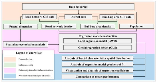
Figure 1.
Flowchart showing the methodology of this study.
2. Literature Review
The concept of fractal geometry was coined by Mandelbrot to describe the self-similarity of the British coastline [13]. Unlike Euclidean geometry, fractal theory considers that a geographical phenomenon has fractal characteristics, i.e., scale invariance and self-similarity, whether formed naturally or man-made [14]. The city is a typical man-made geographical phenomenon with significant fractal characteristics. Hence, researchers have attempted to introduce fractal geometry into the field of urban study, using fractal dimensions to describe urban morphology, analyze the relationship among urban functions, and then explore the inner laws of urban evolution and development. For instance, Shen et al. calculated the fractal dimensions of the urbanized area of 20 cities in America, analyzed the relationship between urbanized area and population, and verified the correlation between them [15].
Fractal geometry theory has also been widely applied in the study of urban transportation networks. Benguigui first analyzed the fractal characteristics of railway networks using fractal dimensions [16]. Based on this, an analysis was conducted on the public transportation network in Paris, demonstrating the presence of fractal characteristics [17]. As research progressed, it was found that urban road networks exhibit a hierarchical structure due to the existence of a road network classification, where each level possesses similar structural characteristics [12]. Specifically, high-grade roads intersect and collectively form the fundamental morphology of the urban road network, while low-grade roads extend from the high-grade road network, creating a more intricate local road network structure within a limited area. This gradually gives rise to a complex network. Throughout this process, as the local structure of the urban road network becomes increasingly intricate, its fractal characteristics also improve (see Figure 2).
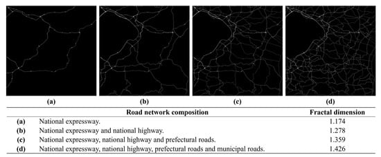
Figure 2.
Fractal dimension of road network composed of different classes of roads.
Fractal geometry has provided a new perspective for studying urban road network morphology. Urban road networks with stronger fractal characteristics, characterized by higher fractal dimensions, tend to have more well-developed branching structures, thus being easier to achieve [18,19]. Therefore, researchers have focused on factors that influence the fractal characteristics of urban road networks. It has been found that the fractal characteristics of urban road networks are influenced by various factors, mainly divided into two aspects: The first is road network scale. The fractal dimension essentially measures the filling efficiency of the road network in urban space, making a relatively larger road scale a necessary condition for achieving a higher fractal dimension in urban road networks [20,21]. Abid found a significant positive correlation between the fractal dimension of urban road networks and road length [22,23]. The second is the characteristics of a city. Lu et al. analyzed the relationship between the fractal dimension of urban road networks and urban indicators such as population and the number of buildings and found that the fractal dimension of urban road networks increases with urban expansion [19]. Moreover, Lan et al. attempted to investigate the allometric relationships between the fractal dimension of urban road networks and urban development indicators [24]. Subsequent studies have confirmed that urban indicators such as population size and building density have an impact on the fractal characteristics of urban road networks.
This chapter reviewed the applications of fractal geometry in city and road network morphology. The morphological evolution and development of urban road networks are influenced by various factors, such as the geographical environment, urban planning, and socio-economic aspects. Consequently, there are significant differences in the morphology of the road network across different regions. Therefore, we believe that considering the impact of spatial variations is a crucial aspect in the study of urban road network morphology and fractal characteristics. However, despite the existing research that has studied the relationship between the fractal characteristics of urban road networks and the influencing factors, the analysis based on the assumption of spatial stationarity cannot account for the effects of spatial variations. Therefore, this study takes spatial non-stationarity as a premise to analyze and validate the spatial heterogeneity between the fractal characteristics of urban road networks and the related influencing factors.
3. Methodology
3.1. Study Area
Tokyo Metropolis (hereinafter referred to as Tokyo), which is located on the east coast of Honshu Island, is the capital and the political and economic center of Japan. It covers a land area of approximately 2194 square kilometers and has an extremely large population. As of this writing, the total population of Japan is about 124.47 million, and the population of Tokyo is approximately 14.04 million, accounting for approximately 10.88% of the total population of Japan [25]. In this study, 23 special wards, 26 cities, 3 towns, and 1 village of Tokyo (excluding the outlying islands) with unique demographic, socio-economic, and land use characteristics, were selected as study subjects (see Figure 3). The urban morphology of Tokyo is shaped by various factors, including its history, geography, and economic development, which have resulted in a highly complex road network consisting of national expressways, national highways, prefectural roads, municipal roads, etc. They form the skeleton of Tokyo’s transportation infrastructure together (see Figure 4). The selection of Tokyo as the study area is primarily driven by its unique urban characteristics. Its large population, developed transportation system, and diverse land use patterns make it an ideal case for investigating the spatial heterogeneity in the relationship between influencing factors and the fractal characteristics of urban road networks.
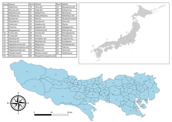
Figure 3.
Location and administrative division of Tokyo.
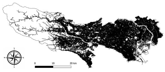
Figure 4.
Road network of Tokyo.
3.2. Data Collection and Processing
A variety of data covering source population, urban transportation, and land use were used to analyze the spatial relationship between the fractal characteristics of the urban road network and influencing factors. Specifically, the population and area data for each administrative district in Tokyo were acquired from the official website of the Tokyo Metropolitan Government [25]. The geographic information data were obtained from two sources: The district boundaries were obtained from the open database of the Ministry of Land, Infrastructure, Transport, and Tourism (MLIT) of Japan [26]. The data on road networks and urban land use were obtained from OpenStreetMap (OSM) [27,28,29]. Specific details are shown in Table 1.

Table 1.
Details of data collection.
3.3. Calculation of Fractal Dimension
The box-counting method was selected to calculate the fractal dimension; it is a common method based on the Hausdorff dimension [30,31]. As shown in Figure 5, taking a square map of a road network as an instance, assume the side length of the road network map is 1, take a square grid with width 1/d to cover the road network map, and record the number of boxes N(d) that cover the road object. By progressively increasing the value of d and recording N(d), we can analyze the relationship between the grid width and the number of boxes covering the road network. If the set has fractal characteristics, the scatter plot of d as the independent variable and N(d) as the dependent variable will follow a straight line with a negative slope −D in the log–log coordinate system [32]. The value of D is the fractal dimension of the road network (see Equation (1)).
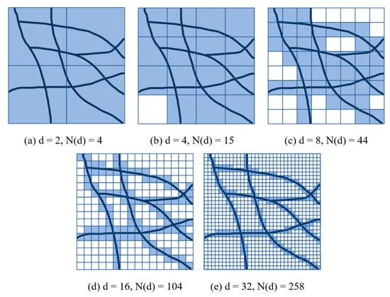
Figure 5.
The principle of calculating fractal dimension of road network using box-counting method.
A Python script was used to count the number of boxes N(d) for each urban road network and perform a linear regression on the results to estimate the fractal dimensions.
3.4. Spatial Analysis of Fractal Dimension of Urban Road Network
In this study, a two-step spatial analysis was carried out as follows: First, a spatial autocorrelation analysis was performed to verify the non-stationarity of the spatial distribution of the fractal dimension, which is the prerequisite for subsequent analyses of influencing factors. Second, the global and local regression models were established to determine the spatial heterogeneity in the relationship between fractal dimensions and influencing factors.
3.4.1. Spatial Autocorrelation Analysis
To validate the geographic heterogeneity of the fractal dimension of an urban road network, we performed a spatial autocorrelation analysis using the fractal dimension calculated above as a measure of network characteristics. The global Moran’s index of fractal dimensions was calculated through Equation (2) as follows:
where is the spatial weight between region and region ; and are the road network fractal dimensions of region and region , respectively; is the average of the road network fractal dimensions; and is the total number of regions. Based on this, it is possible to determine whether there is spatial autocorrelation in the spatial distribution of the fractal dimension of the urban road network.
The analysis of hotspots and coldspots is conducted using Local Indicators of Spatial Association (LISA). This analysis provides further insight into the spatial distribution characteristics of the fractal dimension of the urban road network [33,34]. Here, the local Moran’s index was selected as the local indicator and calculated through Equation (3).
Specifically, this analysis identifies four distinct spatial correlation patterns for the fractal dimension of the road network: (1) High–High pattern, which refers to areas with high road network fractal dimension values and surrounding areas with similarly high values, indicating a clustered spatial distribution; (2) Low–Low pattern, which refers to areas with low road network fractal dimension values and surrounding areas with similarly low values, also indicating a clustered spatial distribution; (3) High–Low pattern, which refers to areas with high road network fractal dimension values and surrounding areas with lower values, indicating a dispersed spatial distribution; and (4) Low–High pattern, which refers to areas with low road network fractal dimension values and surrounding areas with higher values, also indicating a dispersed spatial distribution.
3.4.2. Constructions of Regression Model
Geographically weighted regression (GWR) is a spatial analysis method based on spatial non-stationarity, which is a type of local regression model built upon multiple linear regression. The basic form of a multiple regression model is shown in Equation (4):
where is the fractal dimension of the urban road network, is the intercept of the regression model, is the value of variable , is the coefficient of explanatory variable , and is the error term.
GWR is an extension of the multiple regression model, which can capture spatial heterogeneity in the relationship between explanatory variables and response variables by constructing a spatially varying weighting matrix based on the geographic coordinates of sample regions [35,36]. The form of GWR is shown in Equation (5):
where represents the fractal dimension of the urban road network in region , are the geographic coordinates of the centroid of region , is the intercept of region , and is the kth regression coefficient on region .
Referring to previous studies of the fractal characteristics of urban road networks, we have found that various factors covering society, land use, and road scale influence the fractal characteristics of road networks [37,38]. In this study, population, build-up area density, and road network density were selected as explanatory variables. The details of the explanatory variables are presented in Table 2, and the spatial distributions of the explanatory variables are shown in Figure 6.
Table 2.
Description of explanatory variables.
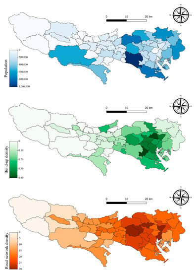
Figure 6.
The spatial distributions of explanatory variables.
The MGWR v2.2 software was selected to establish the GWR model. It was developed by the School of Geographical Sciences and Urban Planning at Arizona State University and performs well in determining optimal bandwidth, constructing weight matrices, and estimating coefficients in MGWR and GWR analyses [39]. Specifically, the adaptive bi-square weighting function was used to create the spatial matrices, and the optimal bandwidth was determined through the golden section searching method. It is worth noting that the bandwidth searching was based on the principle of minimizing the corrected Akaike’s information criterion (AICc) instead of the AIC due to the small sample size [40,41].
4. Results and Discussion
The fractal dimensions of the urban road network of each administrative district in Tokyo were calculated using the box-counting method, and the results are presented in Table 3. Despite the difficulty of identifying a clear-cut criterion for determining whether the road network is fractal or not, the process of linear fit yielded a good linear fit across all samples with an average R-squared value of 0.998. Therefore, it can be concluded that the road networks in the study area exhibit significant fractal characteristics.
Table 3.
The Results of Fractal Dimension Estimation.
The results of the spatial autocorrelation analysis of the fractal dimensions are presented in Figure 7. The global Moran’s index was calculated as a value of 0.477, which is statistically significant at the 1% level, as shown in Figure 7a, and the distributions of hotspots and coldspots are shown in Figure 7b. The results show that positive correlation aggregation was observed in approximately 25% of the regions. Specifically, the western area of Tokyo special wards and Katsushika-ku (i.e., the red area in Figure 7b) exhibit a significant High–High pattern, indicating that the fractal dimension of urban road networks in these regions exhibits high-value clustering. The western area of Tokyo (i.e., the blue area in Figure 7b) exhibits a significant Low–Low pattern, indicating that the fractal dimension exhibits low-value clustering. It is evident that the fractal characteristics of urban road networks do not exhibit a random spatial distribution but rather demonstrate significant spatial dependence. This is manifested by the non-uniform and clustering patterns observed in the west–east direction.
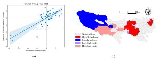
Figure 7.
Results of spatial autocorrelation analysis of the fractal dimension: (a) Moran scatter diagram; (b) LISA clusters of fractal dimension of road network.
The adjusted R-squared of the global model is 0.764, indicating that 76.4% of the variance in the fractal dimension of the road network can be explained by explanatory variables. The estimated coefficients presented in Table 4 demonstrate that all three explanatory variables have a statistically significant impact on the fractal dimension of the road network. Specifically, POP and RND have a positive influence on the fractal dimension, whereas BAD has a negative influence on the fractal dimension of the road network.
Table 4.
Summary of OLS regression coefficient estimates.
The adjusted R-squared of the local model based on GWR is 0.861, indicating that the explanatory variables account for 86.1% of the variance in the fractal dimension of the road network. The summary of standardized regression coefficients is presented in Table 5. These results indicate a positive correlation between the fractal dimension and the explanatory variables covering POP and RND, suggesting that an increase in population or road network density will enhance the fractal dimension of the urban road network. On the other hand, there is a negative correlation between the fractal dimension and BAD, implying that dense land use for building suppresses the increasing fractal dimensions of the road network to some extent. The average coefficient of RND is 0.519, indicating the greatest impact on the fractal dimension of the road network, and the average coefficient of RAD is −0.216, indicating the smallest impact. The standard deviation of POP is 0.027, which is the smallest among the three explanatory variables, indicating that the impact of POP on the fractal dimension of the road network is the most stable across the study area. The standard deviation of RND is 0.249, which is much higher than POP and RAD, indicating that, despite RND having the largest impact, spatial differences are also the greatest.
Table 5.
Summary of GWR regression coefficient estimates.
The spatial distribution of GWR regression coefficients is shown in Figure 8, which shows a gradually decreasing trend of the influence of the three explanatory variables on the fractal dimension of the urban road network from west to east. This suggests that, in the eastern region, variations in population, built-up area density, and road network density make it more difficult to result in changes in the fractal dimension of the urban road network. In contrast, the fractal dimension of the road network in the western region exhibits higher sensitivity to the variations in all the explanatory variables. It is noteworthy that the coefficients of BAD do not exhibit statistical significance at the 95% level in the central area, failing to reject the null hypothesis. This indicates that the impact of BAD on the fractal dimension of the road network is not always significant in the study area. Additionally, through further analysis of the study area, we believe that the improvement in the fractal characteristics of the urban road network will slow down gradually with the increase in urbanization level. The urbanization level in Tokyo exhibits an increasing trend from the western region (known as the Tama area) to the eastern region (known as the special wards of Tokyo), but the impacts of the explanatory variables on the road network characteristics are decreasing.
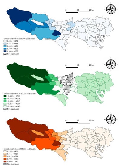
Figure 8.
The spatial distribution of regression coefficients of explanatory variables.
Based on these results, we believe that it is effective to reveal the fractal characteristics of the road network by incorporating spatial heterogeneity into the investigation. Specifically, the fractal dimensions possess spatial heterogeneity through the results of spatial autocorrelation analysis. This is manifested by the significant global Moran’s index and evident clustering patterns observed in the fractal dimension of the road network. Similarly, research has found that urban road network density has a positive spatial correlation as well, which further confirms the inherent spatial heterogeneity of urban road networks [42]. In addition, previous studies have provided an analysis of the relationship between the fractal dimension of urban road networks and influencing factors through a global regression model and yielded similar results [22,23,43]. However, the local regression model, incorporating the spatial heterogeneity into the analysis, performed better in goodness of fit and had a smaller AICc value than the global regression model (see Table 6). Moreover, the local regression model based on GWR effectively captured the underlying spatial differences in the relationship between the fractal characteristics of the urban road network and the influencing factors. The spatial distributions of local regression coefficients illustrate the differences in the impact of factors between the eastern special wards and the western regions of Tokyo. Furthermore, comparing the results of statistical hypothesis testing of the local regression coefficients in different districts, it was found that the influence of factors on the fractal characteristics of road networks may be confined to specific districts. Therefore, we believe that spatial heterogeneity is an important factor in the analysis of the fractal characteristics of urban road networks. Through the spatial autocorrelation analysis of the fractal dimensions of the urban road network, the spatial variation in the spatial distribution of the urban road network was further demonstrated. Then, the local regression model established by GWR exhibited superiority over the global model, proving that it is feasible and beneficial to incorporate spatial heterogeneity into modeling. Moreover, the results of this study provide urban planners and decision-makers with an intuitive and accurate understanding of the morphological characteristics of urban road networks. This can facilitate the formulation of more targeted road network planning strategies based on the specific characteristics of different cities or regions.
Table 6.
Comparison between the global and local regression models.
5. Conclusions
This study analyzed the spatial heterogeneity of fractal characteristics and influencing factors of urban road networks based on the assumption of spatial non-stationarity. We found that the fractal characteristics of the urban road network in Tokyo have significant positive spatial autocorrelation, indicating that the intensities of the fractal characteristics in different districts are influenced not only by the urban indicators but also by the properties surrounding the road network. We selected population, built-up area density, and road network density as explanatory variables and constructed a global regression model using OLS and a local regression model using GWR. The regression results exhibited that, through incorporating spatial heterogeneity, the local regression model distinctly improved the goodness of fit compared to the global regression model. Furthermore, the local regression model successfully revealed local variations in the relationship between the fractal dimension of the road network and the explanatory variables. This is evidenced by the differences in values and the significance tests of local regression coefficients among different districts. Fractal geometry provides an effective quantitative analysis approach for studying urban road network morphology. Urban road networks with stronger fractal characteristics exhibit a more hierarchical structure and greater spatial coverage, which not only enhance accessibility but also improve the operational efficiency of the transportation system, reduce carbon emissions, and promote sustainable urban development.
In this study, we selected the road networks of Tokyo as the study object. Despite the fact that a single sample may lead to a certain limitation in the results of the analysis, as the capital of Japan, Tokyo has developed an extremely complete road network after long-term urban development, and we still observed significant spatial heterogeneity in the relationship between the fractal characteristics of urban road networks and the influencing factors related to population, land use, and road network scale. Hence, it can be considered that spatial heterogeneity is pervasive in the evolution of urban road networks. It can be expected that more pronounced spatial heterogeneity may emerge for road networks in cities that are in the process of rapid development and evolution. Additionally, it is noteworthy that this study examined the impacts of population, build-up density, and road network density on the fractal dimensions of urban road networks. However, we believe that these relationships may vary with the function and characteristics of different cities. For instance, in a city where industrial activities are the main economic drivers, relevant industrial indicators could play a vital role in influencing the fractal characteristics of road networks. However, this study did not analyze this aspect in depth. Therefore, future research could be further extended to other cities, especially those in different development stages and patterns, to gain a more comprehensive understanding and insight.
Compared to traditional modeling approaches, the local model based on GWR demonstrates better goodness of fit and local effects through incorporating spatial heterogeneity. It provides valuable insights into understanding the relationship between the morphological characteristics of urban road networks and the social and land-use conditions in cities. It enables planners and decision-makers to make reasonable predictions regarding the future evolution of urban road networks and formulate more targeted planning strategies and policy measures.
Author Contributions
Conceptualization, Y.Y.; Methodology, Y.Y.; Software, Y.Y.; Validation, Y.Y.; Resources, Y.Y.; Data curation, Y.Y.; Writing—original draft preparation, Y.Y.; Writing—review and editing, Y.Y. and B.F.; Visualization, Y.Y.; Supervision, B.F. All authors have read and agreed to the published version of the manuscript.
Funding
This research received no external funding.
Institutional Review Board Statement
Not applicable.
Informed Consent Statement
Not applicable.
Data Availability Statement
The road network and land use information of study area are available on: https://download.geofabrik.de/asia/japan/kanto.html; The population and district area information are available on: https://www.metro.tokyo.lg.jp/tosei/tokyoto/profile/gaiyo/kushichoson.html.
Conflicts of Interest
The authors declare no conflict of interest.
References
- Goldberger, A.L.; West, B.J. Fractals in physiology and medicine. Yale J. Biol. Med. 1987, 60, 421. [Google Scholar]
- Hirata, T.; Satoh, T.; Ito, K. Fractal structure of spatial distribution of microfracturing in rock. Geophys. J. Int. 1987, 90, 369–374. [Google Scholar] [CrossRef]
- Okubo, P.G.; Aki, K. Fractal geometry in the San Andreas fault system. J. Geophys. Res. Solid Earth 1987, 92, 345–355. [Google Scholar] [CrossRef]
- Haskell, J.P.; Ritchie, M.E.; Olff, H. Fractal geometry predicts varying body size scaling relationships for mammal and bird home ranges. Nature 2002, 418, 527–530. [Google Scholar] [CrossRef] [PubMed]
- Charbonneau, P.; Kurchan, J.; Parisi, G.; Urbani, P.; Zamponi, F. Fractal free energy landscapes in structural glasses. Nat. Commun. 2014, 5, 3725. [Google Scholar] [CrossRef] [PubMed]
- Pan, F.; Sun, Y.; Jiang, N.; Jian, Z.; Mei, Y.; Liu, Q. Analysis of the Coordination of Built-Up Area Expansion and Population Growth in the Shandong Peninsula Urban Agglomeration. Sustainability 2023, 15, 7763. [Google Scholar] [CrossRef]
- Gertik, A.; Karaman, A. The Fractal Approach in the Biomimetic Urban Design: Le Corbusier and Patrick Schumacher. Sustainability 2023, 15, 7682. [Google Scholar] [CrossRef]
- Bărbulescu, A.; Dumitriu, C.Ș. Fractal Characterization of Brass Corrosion in Cavitation Field in Seawater. Sustainability 2023, 15, 3816. [Google Scholar] [CrossRef]
- Qi, L.; Zhou, X.; Peng, X.; Chen, X.; Wang, Z.; Dai, J. A Study on the Pore Structure and Fractal Characteristics of Briquettes with Different Compression Loads. Sustainability 2022, 14, 12148. [Google Scholar] [CrossRef]
- Ciobotaru, A.-M.; Andronache, I.; Ahammer, H.; Radulovic, M.; Peptenatu, D.; Pintilii, R.-D.; Drăghici, C.-C.; Marin, M.; Carboni, D.; Mariotti, G. Application of Fractal and gray-level co-occurrence matrix indices to assess the forest dynamics in the curvature Carpathians—Romania. Sustainability 2019, 11, 6927. [Google Scholar] [CrossRef]
- Zhang, Z.; Xiao, R.; Yu, W.; Liu, Y.; Lin, M.; Wang, M. Characterizing factors associated with built-up land expansion in urban and non-urban areas from a morphological perspective. Sustainability 2017, 9, 1411. [Google Scholar] [CrossRef]
- Zhang, H.; Li, Z. Fractality and self-similarity in the structure of road networks. Ann. Assoc. Am. Geogr. 2012, 102, 350–365. [Google Scholar] [CrossRef]
- Mandelbrot, B. How long is the coast of Britain? Statistical self-similarity and fractional dimension. Science 1967, 156, 636–638. [Google Scholar] [CrossRef]
- Mandelbrot, B.B.; Mandelbrot, B.B. The Fractal Geometry of Nature; WH freeman: New York, NY, USA, 1982; Volume 1. [Google Scholar]
- Shen, G. Fractal dimension and fractal growth of urbanized areas. Int. J. Geogr. Inf. Sci. 2002, 16, 419–437. [Google Scholar] [CrossRef]
- Benguigui, L. The fractal dimension of some railway networks. J. Phys. I 1992, 2, 385–388. [Google Scholar] [CrossRef]
- Benguigui, L. A fractal analysis of the public transportation system of Paris. Environ. Plan. A 1995, 27, 1147–1161. [Google Scholar] [CrossRef]
- Tannier, C.; Vuidel, G.; Houot, H.; Frankhauser, P. Spatial accessibility to amenities in fractal and nonfractal urban patterns. Environ. Plan. B Plan. Des. 2012, 39, 801–819. [Google Scholar] [CrossRef]
- Lu, Y.; Tang, J. Fractal dimension of a transportation network and its relationship with urban growth: A study of the Dallas-Fort Worth area. Environ. Plan. B Plan. Des. 2004, 31, 895–911. [Google Scholar] [CrossRef]
- Ahmed, M.; Bokhari, S. Mapping with space filling surfaces. IEEE Trans. Parallel Distrib. Syst. 2007, 18, 1258–1269. [Google Scholar] [CrossRef]
- Sreelekha, M.; Krishnamurthy, K.; Anjaneyulu, M. Fractal assessment of road transport system. Eur. Transp. 2017, 65, 1–13. [Google Scholar]
- Abid, R.I.; Tortum, A. The Fractal Geometry of Turkey’s Urban Transportation Networks. KSCE J. Civ. Eng. 2021, 25, 1455–1466. [Google Scholar] [CrossRef]
- Abid, R.I.; Tortum, A.; Atalay, A. Fractal Dimensions of Road Networks in Amman Metropolitan Districts. Alex. Eng. J. 2021, 60, 4203–4212. [Google Scholar] [CrossRef]
- Lan, T.; Li, Z.; Zhang, H. Urban allometric scaling beneath structural fractality of road networks. Ann. Am. Assoc. Geogr. 2019, 109, 943–957. [Google Scholar] [CrossRef]
- Population Estimates of Tokyo Metropolis; Statistics Division, Bureau of General Affairs: Tokyo, Japan, 2023.
- National Land Information Division, National Spatial Planning and Regional Policy Bureau, MLIT of Japan. National Spatial Data Download Site. Available online: https://nlftp.mlit.go.jp/ksj/gml/datalist/KsjTmplt-N03-v3_1.html (accessed on 5 February 2023).
- Geofabrik GmbH, OpenStreetMap Contributors. Download OpenStreetMap Data for This Region: Japan. Available online: https://download.geofabrik.de/asia/japan.html (accessed on 20 February 2023).
- OpenStreetMap Wiki Japan Tagging. Available online: https://wiki.openstreetmap.org/wiki/Japan_tagging (accessed on 11 March 2023).
- OpenStreetMap Wiki Contributors Highways. Available online: https://wiki.openstreetmap.org/w/index.php?title=JA:%E9%81%93%E8%B7%AF&oldid=2473196 (accessed on 11 March 2023).
- Sarkar, N.; Chaudhuri, B.B. An efficient differential box-counting approach to compute fractal dimension of image. IEEE Trans. Syst. Man Cybern. 1994, 24, 115–120. [Google Scholar] [CrossRef]
- Lalley, S.P.; Gatzouras, D. Hausdorff and Box Dimensions of Certain Self–Affine Fractals. Indiana Univ. Math. J. 1992, 41, 533–568. [Google Scholar] [CrossRef]
- Liebovitch, L.S.; Toth, T. A fast algorithm to determine fractal dimensions by box counting. Phys. Lett. A 1989, 141, 386–390. [Google Scholar] [CrossRef]
- Anselin, L. Local indicators of spatial association—LISA. Geogr. Anal. 1995, 27, 93–115. [Google Scholar] [CrossRef]
- Anselin, L. An Introduction to Spatial Autocorrelation Analysis with GeoDa; Spatial Analysis Laboratory, University of Illinois: Urbana, IL, USA, 2003. [Google Scholar]
- Brunsdon, C.; Fotheringham, S.; Charlton, M. Geographically weighted regression. J. R. Stat. Soc. Ser. D 1998, 47, 431–443. [Google Scholar] [CrossRef]
- Brunsdon, C.; Fotheringham, A.S.; Charlton, M.E. Geographically weighted regression: A method for exploring spatial nonstationarity. Geogr. Anal. 1996, 28, 281–298. [Google Scholar] [CrossRef]
- Lu, Z.; Zhang, H.; Southworth, F.; Crittenden, J. Fractal dimensions of metropolitan area road networks and the impacts on the urban built environment. Ecol. Indic. 2016, 70, 285–296. [Google Scholar] [CrossRef]
- Sun, Z.; Zheng, J.; Hu, H. Fractal pattern in spatial structure of urban road networks. Int. J. Mod. Phys. B 2012, 26, 1250172. [Google Scholar] [CrossRef]
- Oshan, T.M.; Smith, J.P.; Fotheringham, A.S. Targeting the spatial context of obesity determinants via multiscale geographically weighted regression. Int. J. Health Geogr. 2020, 19, 11. [Google Scholar] [CrossRef] [PubMed]
- Akaike, H. A new look at the statistical model identification. IEEE Trans. Autom. Control 1974, 19, 716–723. [Google Scholar] [CrossRef]
- Charlton, M.; Fotheringham, S.; Brunsdon, C. Geographically weighted regression. In White Paper; National Centre for Geocomputation: Maynooth, Ireland, 2009; Volume 2. [Google Scholar]
- Hu, X.; Wu, C.; Wang, J.; Qiu, R. Identification of spatial variation in road network and its driving patterns: Economy and population. Reg. Sci. Urban Econ. 2018, 71, 37–45. [Google Scholar] [CrossRef]
- Deng, H.; Wen, W.; Zhang, W. Analysis of Road Networks Features of Urban Municipal District Based on Fractal Dimension. ISPRS Int. J. Geo-Inf. 2023, 12, 188. [Google Scholar] [CrossRef]


Disclaimer/Publisher’s Note: The statements, opinions and data contained in all publications are solely those of the individual author(s) and contributor(s) and not of MDPI and/or the editor(s). MDPI and/or the editor(s) disclaim responsibility for any injury to people or property resulting from any ideas, methods, instructions or products referred to in the content. |
© 2023 by the authors. Licensee MDPI, Basel, Switzerland. This article is an open access article distributed under the terms and conditions of the Creative Commons Attribution (CC BY) license (https://creativecommons.org/licenses/by/4.0/).