Article

Spatial Distribution of Soil Organic Carbon and Total Nitrogen in a Micro-Catchment of Northeast China and Their Influencing Factors

1
College of Geographical Science, Harbin Normal University, Harbin 150025, China
2
Key Laboratory of Mollisols Agroecology, Northeast Institute of Geography and Agroecology, Chinese Academy of Sciences, Harbin 150081, China
3
College of Resources and Environment, Northeast Agricultural University, Harbin 150030, China
4
Institute of Soil and Water Conservation, Chinese Academy of Sciences and Ministry of Water Resources, Xianyang 712100, China
*
Author to whom correspondence should be addressed.
Sustainability 2023, 15(8), 6355; https://doi.org/10.3390/su15086355
Submission received: 28 February 2023 / Revised: 28 March 2023 / Accepted: 6 April 2023 / Published: 7 April 2023
(This article belongs to the Special Issue Soil Erosion and Its Response to Vegetation Restoration)

Abstract

:
This study aimed to analyze the spatial distribution of soil organic carbon (SOC) and total nitrogen (STN) in a micro-catchment area comprising farmland and a gully with vegetation restoration (artificial forest and grassland) and their influencing factors. We surveyed a total of 52 topsoil sampling sites to measure the SOC and STN content, as well as topographical factors (elevation, curvature, slope gradient, and aspect), soil properties (bulk density, aggregate distribution, soil texture, and soil moisture), and land use and management. We used traditional statistical and geostatistical methods to analyze the spatial variability of SOC and STN. The results of this study indicate that SOC and STN content varied moderately across the entire micro-catchment area, with greater values in the west (gully head area) than in the east (gully mouth area). Additionally, SOC and STN were significantly positively correlated with soil water content, >2 mm size aggregate fraction, and elevation, but negatively correlated with <0.053 mm size fraction. Land use types also influenced the spatial distribution of SOC and STN contents, with the highest averages of SOC and STN content found at the edge of farmland road and grassland, respectively, and the lowest values in bare land. This study provides a valuable supplement to the understanding of SOC and STN in micro-catchment areas, and the research results also support the evaluation of the impact of gully erosion control on SOC and STN dynamics after vegetation restoration. Overall, vegetation restoration should be adopted for gully erosion control and sustainable agricultural development in the Mollisols region of Northeast China.

1. Introduction

Soil erosion, particularly gully erosion, is one of the most daunting environmental challenges faced globally [1,2]. Gully erosion is a highly visible form of erosion that causes significant soil loss [3,4]. Presently, research on gully erosion is primarily centered on monitoring and modeling the spatial distribution and morphological development of gullies [5,6], and the impact of gullies on soil quality [7,8].
SOC and STN are critical components of the ecosystem [9,10]. They contribute to maintaining soil health, water retention capacity, and other soil factors that support agricultural production and food security [11,12]. Bogunovic et al. [13] discovered that the spatial distribution of SOC and STN in the Livno Polje was quite similar, with the highest concentrations observed in the northwestern part of the study area and the lowest in the central and southwestern parts, as a result of clay content and land use. Li et al. [14] demonstrated that the features of soil nutrient distribution in the Zhuxi small watershed presented ribbon and plaque shapes, with significant spatial variability in the western region. The spatial heterogeneity of soil nutrients was significantly influenced by land use. Furthermore, the spatial variability of SOC and STN is influenced by soil properties (e.g., soil texture) and topographic factors, such as elevation, aspect, and altitude [15,16].
Currently, gully erosion is a serious problem in the black soil area of Northeast China. The formation of gullies affects mechanical operation, which results in nutrient loss and grain production reduction [17]. Tang et al. [18] found that the gully erosion of Hebei Catchment in Heilongjiang Province reduced SOC and STN contents by 9.04 g/kg and 0.92 g/kg, respectively. Furthermore, gully erosion leads to differences in the spatial distribution of soil nutrients [19]. Qi et al. [20] found the content of SOC and STN in the gully was higher at the catchment on the slope and below the slope in June, and higher below the slope in August and September. Many previous studies have focused on the spatial distribution of soil nutrients at the catchment or watershed scale [19,21], but few studies have explored the spatial distribution of SOC and STN and its influencing factors in a micro-catchment with one gully. Hence, we selected a micro-catchment that combined farmland and a stable gully after vegetation restoration (artificial forest and grassland), and used classical statistics and geostatistics methods to measure the spatial distribution of SOC and STN and their influencing factors. The results provide a basis for the redistribution law after the loss of nutrients from gully erosion, and have great significance for the subsequent control of gullies, the protection of black soil resources, and promoting the sustainable development of agriculture. The main purpose of this study was to (1) describe the distribution of SOC and STN in a micro-catchment and (2) to analyze the effects of soil properties, topography, and land use on the distribution of SOC and STN.

2. Material and Method

2.1. Study Area

The research area is located in Guangrong Village (47°20′–47°23′ N, 126°49′–126°51′ E), in Hailun City, Northeast China, a semi-arid and semi-humid region. The soil type is the typical Mollisol, which is classified as Phaeozem by US Soil Taxonomy (Soil Survey Staff, Washington, DC, USA, 2010). The soil texture is silty clay loam with a high clay content, high SOM content, high-water holding capacity, and poor drainage. The average annual rainfall in the study area is 550 mm, and the average annual temperature is 1.5 °C. This region has a continental monsoon climate of the middle temperate zone, which is cold and dry in winter and hot and rainy in summer. The rainfall is mainly concentrated in June to August, and has the characteristics of a short duration, high intensity, and uneven distribution. The study area is a typical rolling and hilly region. Due to conversion of natural grassland/forest to arable land, soil erosion is very serious in this region [20,22].
In this study, a micro-catchment (Figure 1) that combined farmland and a stable gully after vegetation restoration (artificial forest and grassland) was elected as the research area. The dominant vegetation in the gully is the Cathay poplar, Pinus sylvestris, and barnyard grass. The altitude of the study area is 224.77–263.15 m, the length of the gully is 669.39 m, the slope of the gully is 4.14°, and the catchment area is 0.56 km2. The land use includes farmland, artificial forest, natural vegetation restoration (grassland), bare land and farmland roads. The farmland was reclaimed in the 1960s. The artificial forest was planted in 2009 and the farmland roads were also built in 2009. The crops planted on the farmland are maize and soybean. The average fertilization procedure is as follows: 20.25 kg N·hm−2, 51.75 kg P·hm−2, and 15.00 kg K·hm−2 for soybean and 138.00 kg N·hm−2, 51.75, kg P·hm−2 and 15.00 kg K·hm−2 for maize.

2.2. Sampling and Measurement

To create a topographic map and determine the catchment area, the UAV was employed to capture low-altitude photographs from a height of 50 m, with an image overlap rate of 70%. The acquired images were processed using Pix4Dmapper software from Switzerland, and the resulting DSM isolines were processed in ArcGIS 10.4 software (Esri, Redlands, CA, USA) to generate the contours of the catchment area. The catchment area was manually circled, and its size was calculated [23]. A total of 52 soil samples were collected from the micro-catchment area at a depth of 0–5 cm using the sampling spade. The sampling locations were selected based on the micro-catchment’s topography, as shown in Figure 1b.
Samples were air-dried, and the plant roots and gravels were removed and sieved at 0.25 mm to analyze SOC and STN using a VarioEL III element analyzer (Elementar, Langenselbold, Germany). Soil bulk density and soil moisture were measured using the single-ring method (100 cm3). Soil texture was measured using the Malvern Mastersizer 2000 (Malvern Instruments Ltd., Malvern, UK). The aggregate size distribution was measured using various aggregate sizes, which depended on the high-vacuum slow-wetting method that was applied [24]; here, three aggregate size classes (2 mm, 0.25 mm, and 0.053 mm) were used in order to test the influence of the initial aggregate size on the size distribution of breakdown fragments.

2.3. Statistics and Geostatistical Analysis

Descriptive statistics were carried out (minimum, maximum, mean, standard deviation (SD), coefficient of variation (CV), kurtosis, and skewness) prior to geostatistical analysis. Statistical analyses were performed with the SPSS 19.0 software (IBM, Armonk, NY, USA). Statistical differences in both SOC and STN in different land uses were tested with the non-parametric Kruskal–Wallis test (K–W).
In this study, GS+9.0 (Gamma Design Software, Plainwell, MI, USA) was used to perform semi-variance analysis of SOC and STN in this study area. The definition of semi-variance is as follows:
r ( h ) = [ 1 / 2 N ( h ) ] [ z i z i + h ] 2
where r(h) = semi-variance for interval distance class h; zi = the measured sample value at point i; zi+h = the measured sample value at point i + h; and N(h) = the total number of sample couples for the lag interval h [19].
Different models were used for fitting, and the most appropriate fitting model was selected according to the size of the residual value (RSS). The model was described as by Robertson, 2008 [25].
(1)
The exponential isotropic model:
r ( h ) = C 0 + C [ 1 exp ( h / A ) ]
(2)
The Gaussian isotropic model:
r h = C 0 + C 1 exp ( h 2 / A 2 ]
(3)
Spherical isotropic model:
r h = C 0 + C 1.5 h / A 0.5 ( h / A ] 3   for   h     A r ( h ) = C 0 + C   for   h   >   A
r ( h ) = C 0 + C   for   h   >   A
where h = lag interval, C0 = nugget variance ≥ 0, C = structure variance ≥ C0, and A = range parameter.
To analyze the spatial distribution, the SOC and STN were interpolated via ordinary kriging using the ArcGIS 10.1 software (Environmental Systems Research Institute, Redlands, CA, USA).

3. Results

3.1. Descriptive Statistics for SOC and STN

As shown in Table 1, a significant spatial difference was found in both SOC and STN. The SOC content ranged from 13.37 to 41.19 g/kg, with an average value of 25.68 g/kg in the study area. The STN content ranged from 1.10 to 3.03 g/kg, with the average value was 1.96 g/kg. The CV of SOC and STN was 29.93% and 28.05%, respectively, which indicated a moderate degree of variation. In K-S test analysis, the SOC and STN contents conformed to a normal distribution. Additionally, the SOC content in the study area was higher than the STN content, and the CV of SOC was slightly greater than that of STN.

3.2. Spatial Distribution for SOC and STN

3.2.1. Geostatistical Analysis of Spatial Patterns in SOC and STN

As illustrated in Table 2, the optimal theoretical semi-variogram models of SOC and STN were the spherical model and Gaussian model, respectively. The nugget (C0)/ sill (C0 + C) ratio can be used to analyze the degree of spatial correlation of soil nutrients [26]. The ratios of nugget to sill for soil organic carbon (SOC) and total nitrogen (STN) were both close to 0, indicating a strong spatial correlation. The effective spatial autocorrelation range for SOC was 48.10 m, while the range for STN was slightly smaller at 39.84 m. These results also suggest that the spatial variability of SOC was slightly greater than that of TN in this micro-catchment.

3.2.2. Spatial Distribution

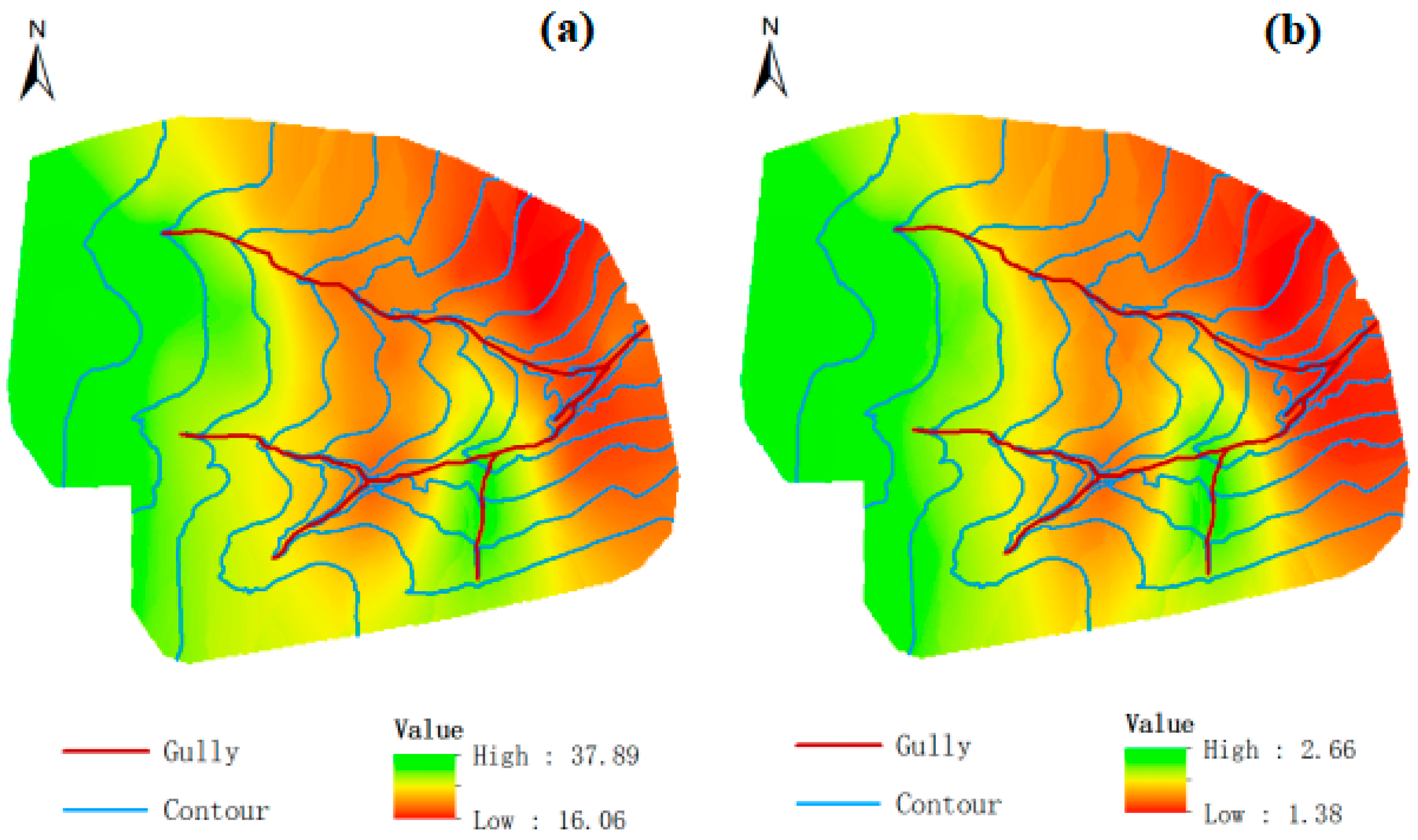
Figure 2 shows that the spatial distribution of soil organic carbon (SOC) was similar to that of total nitrogen (STN), with higher values observed in the western part of the micro-catchment compared to the middle and eastern regions. Notably, great spatial variability of SOC (ranging from 16.06 to 37.89 g/kg), as well as STN (ranging from 1.38 to 2.66 g/kg), was observed near the gully area. Specifically, the highest SOC and STN contents were found at the gully head, and gradually decreased towards the gully mouth. Conversely, the lowest SOC and STN contents were observed near the gully mouth in the northeast region.

3.3. Influencing Factors for Spatial Distribution of SOC and STN

3.3.1. Soil Physical Properties

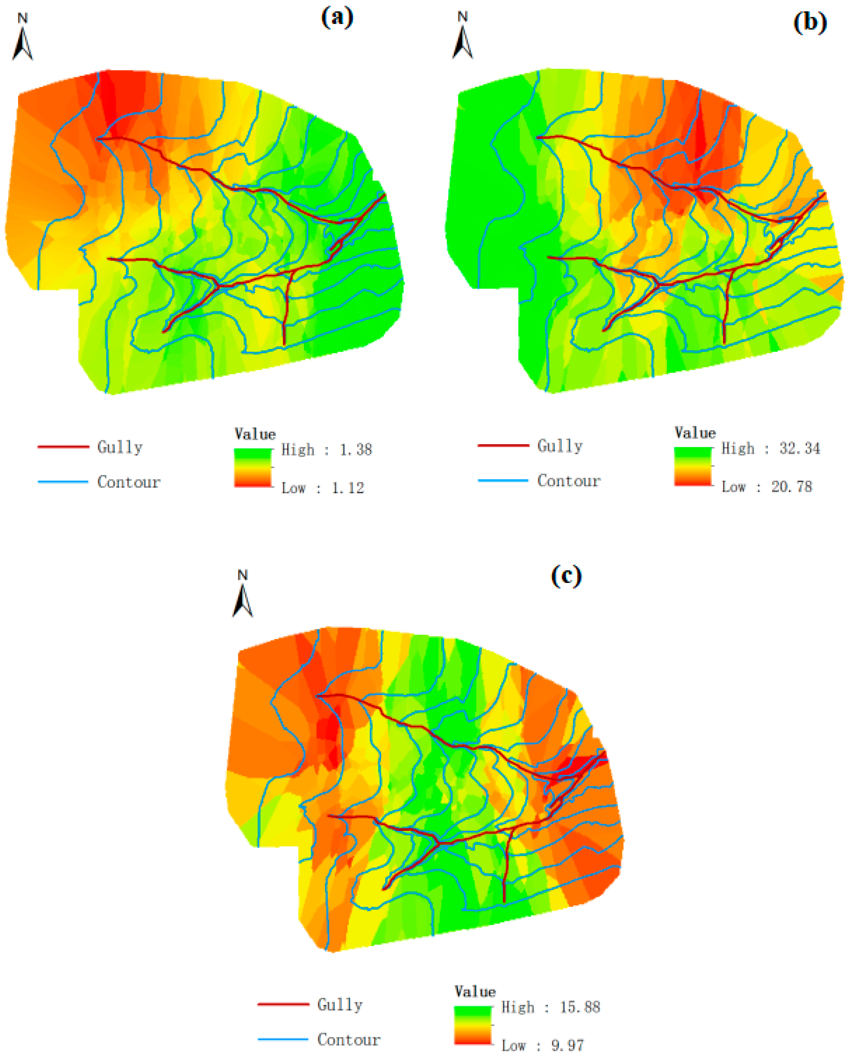
As shown in Figure 3, soil bulk density (BD) values ranged from 1.12 g/cm3 to 1.38 g/cm3, and the BD was lower in the northwest and gradually increased towards the southeast, in contrast to the spatial distribution trend of SOC and STN. However, the soil water content (SWC) ranged from 20.78% to 32.34%, and the SWC was greater in the west, but decreased towards the middle and east regions, in contrast to the spatial distribution of BD. The clay content ranged from 9.97% to 15.88%, and it was lower in the west and east but higher in the middle region. Notably, the spatial distribution of soil clay content in the gully mouth area was relatively consistent with that of SOC and STN, but showed the opposite trend in the gully head areas of the micro-catchment.
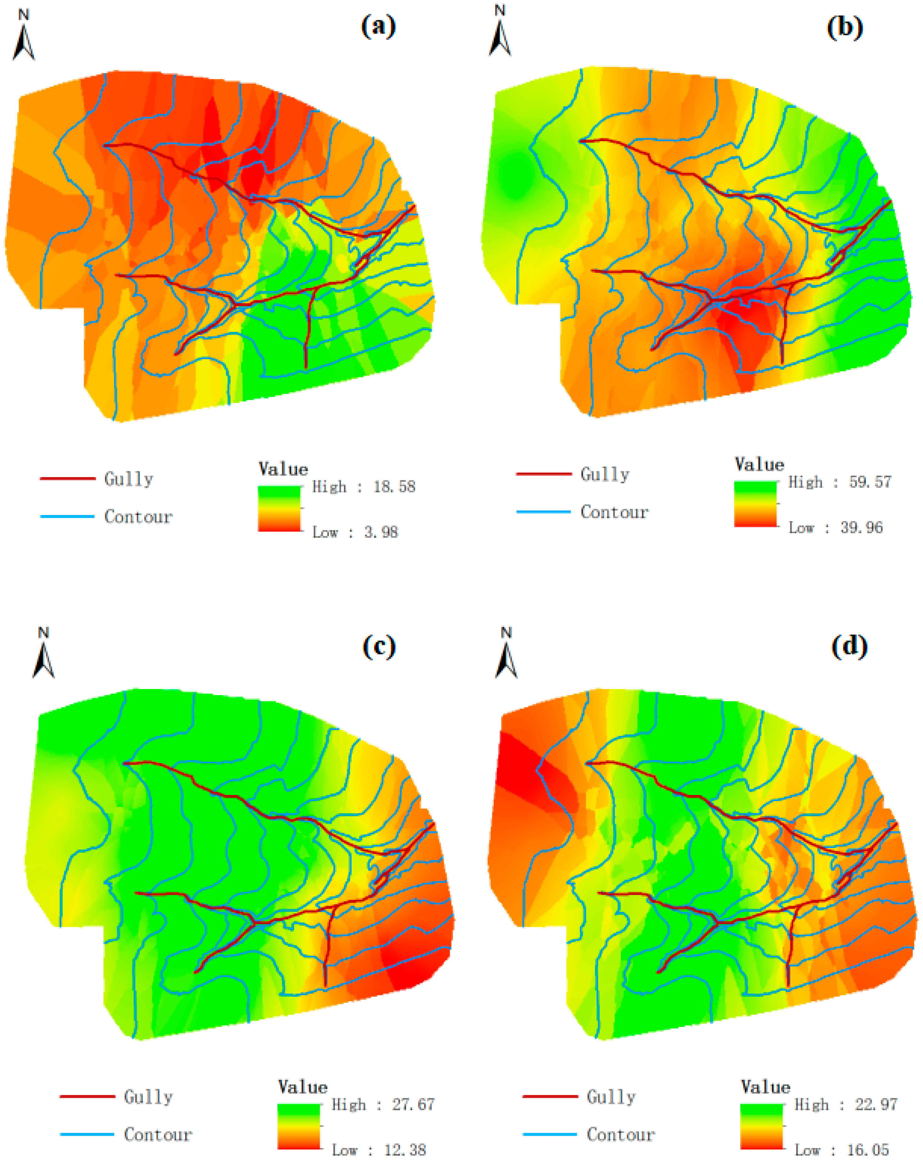
Figure 4 illustrates that soil aggregates with size fractions of >2 mm had a prevalence that ranged from 3.98% to 18.58%, and they were distributed less in the northwest but were more abundant in the southeast. Soil aggregates with size fractions of 0.25–2 mm, with a prevalence ranging from 39.96% to 59.57%, were less abundant in the middle region but were more abundant in the east and west regions. Soil aggregates with size fractions of 0.053–0.25 mm ranged in prevalence from 12.38% to 27.67%, and they were more abundant in the northwest and middle regions but were less abundant in the southeast. Lastly, soil aggregates with size fractions of <0.053 mm ranged in prevalence from 16.05% to 22.97%, and they were more abundant in the middle region but were less abundant in the east and west regions. Soil aggregates with size values of 0.25–2 mm were more prevalent than those with size values of <0.25 mm.
BD and clay content were not significantly correlated with SOC and STN, but SWC had a significant positive correlation with the content of SOC and STN (Table 3). Meanwhile, the contents of SOC and STN in the study area were significantly positively correlated with the >2 mm size aggregate fractions, but were negatively correlated with the <0.053 mm size fractions. The 0.25–2 mm and 0.053–0.25 mm size aggregate fractions were not significantly correlated with SOC and STN.

3.3.2. Topography

The average elevation and slope gradient of the micro-catchment were 243.24 m (ranging from 226.04 m to 256.71 m) and 7.28° (ranging from 0.20° to 34.36°), respectively. The greater slope gradient was found in the gully area. The mean slope aspect was 164.98 (southeast direction). Table 4 reveals that the spatial distribution of soil organic carbon (SOC) and total nitrogen (STN) contents in this study was correlated with topographic conditions. The correlation analyses indicated that SOC and STN contents were significantly positively correlated with elevation, but were not significantly related to slope gradient, aspect, or curvature.

3.3.3. Land Use and Management

The average SOC content by land use followed the order: farmland road > farmland (soybean) > grassland > artificial forest > farmland (maize) > bare land; the average of STN content followed the order: grassland > farmland road edge > farmland (soybean) > artificial forest > farmland (maize) > bare land (Table 5). The average SOC and STN contents in bare land were significantly lower than those in other land use types, but no significant differences in SOC and STN were found among other land use and management systems.

4. Discussion

4.1. Spatial Heterogeneity of SOC and STN

Exploring the effects of gullies on the spatial distribution of SOC and STN is critical to control the risk of gully erosion and agricultural sustainable development in sloping farmland. Micro-catchments with one gully are useful in clarifying the spatial distribution of SOC and STN and their influencing factors. In our study, significant spatial variability was found in both SOC and STN in the micro-catchment. Their nugget/sill ratios were close to 0, indicating that SOC and STN had strong spatial correlation and were significantly influenced by soil properties and topographic factors, and the elevation was the strongest influencing factor. These findings are consistent with previous research [13,20,27]. The study also showed that SOC and STN exhibited a west-to-east spatial distribution pattern, which was also related to elevation. Notably, significant differences in the spatial distributions of SOC and STN were observed in the gully area of the micro-catchment, with a decreasing trend from the gully head to gully mouth (Figure 2). This finding is similar to the research results of Li et al. [14], who reported higher SOC and STN contents in the upper and lower reaches of the watershed compared to the middle reaches. In the micro-catchment, the land use in the gully head area was predominantly farmland, which is prone to soil and water loss during heavy rainfall events. In contrast, vegetation restorations such as artificial forest and grassland were implemented in gully erosion control. These measures resulted in the deposition of farmland soil in the gully head area, thereby improving the SOC and STN contents in the surface soil. Additionally, the land use in the gully mouth area was bare land, which is more susceptible to soil loss.
The study area exhibited a greater degree of variation in SOC compared to STN. However, the spatial correlation of SOC was weaker than that of STN. Soybean cultivation was found to promote nitrogen fixation, and the application of nitrogen fertilizer could increase the concentration of STN in the micro-catchment. In a similar study, Wang et al. [27] also reported a slightly larger range and degree of spatial autocorrelation for SOC than STN.

4.2. Factors Influencing Spatial Variation in SOC and STN

Numerous studies have shown that soil properties play a crucial role in shaping SOC and STN contents [27,28]. BD is an essential indicator of soil structure and is known to impact soil permeability, water retention, and nutrient content negatively [29]. Wu et al. [30] found a significant negative correlation between SOC and BD. Similarly, our study yielded comparable results; however, we did not observe any significant correlation between BD and either SOC or STN. Moreover, we did not find any significant correlation between clay content and SOC or STN, while McGrath et al. [31] reported a significant positive correlation between clay and SOC. These differences may be attributed to the study area being a micro-catchment with predominantly farmland, and its soil texture is silty clay loam. BD values ranged mainly from 1.10 to 1.20 g/cm3, and clay content ranged primarily from 14.0 to 17.0%. In our study, we observed a significant positive correlation between SOC and STN contents and soil water content (Figure 3 and Table 3), which aligns with previous findings [16,30]. The higher soil water content stimulated microbial activity, facilitated soil nutrient decomposition and fixation, and promoted soil respiration, ultimately leading to an increase in SOC and STN contents [32,33].
Our study found a significant positive correlation between SOC and STN contents and the >2 mm size aggregate fraction, while a negative correlation was observed with the <0.053 mm size aggregate fraction (Table 3). These findings suggest that soil nutrients are mainly stored in larger aggregates (>2 mm), whereas smaller aggregates (<0.053 mm) contain fewer soil nutrients. Several studies have demonstrated that larger aggregate sizes can protect a larger amount of carbon and are more resistant to erosion, resulting in less soil nutrient loss [34,35]. Chen et al. [35] reported that soil aggregates with >0.25 mm size fractions were the best soil structure and had a positive relationship with SOC and STN contents, which aligns with our research results.
Topographic conditions are known to have a significant impact on the spatial distribution of SOC and STN [21,36]. In our study, we found a significant positive correlation between SOC and STN contents and elevation (Table 4), which is consistent with the findings of Wu et al. [30]. They observed that the lower soil temperature and slower decomposition rate of plant residues by microorganisms at high elevations facilitated the accumulation of organic matter in the soil, leading to improved SOC and STN contents [37]. Additionally, our study revealed that the SOC and STN contents in the gully head area were higher than those in the gully mouth. This could be attributed to the higher elevation and catchment region in the gully head area, which enhances the erosive forces in this area. Furthermore, the dominant land use type in the gully head area is farmland, which has been observed to have higher SOC and STN contents. In addition, the restoration of vegetation in the gully has resulted in the accumulation of lost SOC and STN in the gully head area, while also reducing the runoff and soil loss to the gully mouth area during rainstorms. As a result, the SOC and STN contents in the gully head area are found to be higher. Interestingly, our results indicate that SOC and STN contents had no significant correlation with slope gradient or aspect factors. Zhang et al. [16] found no significant difference in SOC between sunny and shady slopes. However, Wang et al. [27] found a close relationship between slope gradient and soil nutrient losses, which affected the spatial distribution of SOC and STN. Some studies have also found that soil loss was not positively correlated with slope gradient, and opposite results were found after reaching a certain slope gradient [38,39]. In a word, the elevation was the topographic factor with the strongest influence on the spatial distribution of SOC and STN in a micro-catchment with one gully in Northeast China.
The spatial distribution of SOC and STN in the micro-catchment was influenced by different land use patterns. Our results show that the highest average SOC and STN contents were found in farmland road and grassland, while the lowest values were found in bare land. These findings are in line with the study conducted by Zhao et al. [21]. The increased SOC and STN contents on farmland road were attributed to the construction of road infrastructure on farmland, which resulted in the accumulation of soil loss in the farmland roadside and improved soil nutrient contents. Additionally, due to the greater above-ground biomass and fine root density, the SOC and STN contents in grassland and artificial forest were greater than those in farmland [40,41]. Furthermore, the SOC and STN contents in grassland were higher than those in artificial forest. In this study, we also found that the SOC and STN contents in soybean fields were higher than those in maize fields, due to the nitrogen fixation ability of soybean roots. Additionally, our study revealed that the SOC and STN contents in bare land were significantly lower than those in land undergoing revegetation restoration and farmland. Similar results have been reported by previous studies [21,42].
There were no significant differences in SOC and STN contents among different land use types, except for bare land, where the SOC and STN contents were significantly reduced. This reduction was mainly due to the impact of gully erosion. Bare land experiences serious runoff and soil and associated nutrient loss. Furthermore, in 2022, we investigated another gully catchment that did not undergo vegetation restoration measures, which was 1.0 km away from this micro-watershed. The results show that the SOC and STN contents in the gully head area were lower than those in the gully mouth area (these data have not been shown), which was contrary to our findings in this study. Greater SOC and STN contents in the gully head area are beneficial to improve the growth of artificial forests and grasslands and to reduce the risk of eutrophication. Meanwhile, previous studies have reported that vegetation restoration can also effectively reduce gully band expansion and retreat rates [43,44]. Therefore, vegetation restoration has a significant effect on the spatial distribution of SOC and STN, and it is also an effective method for controlling gully erosion and nutrient loss in Northeast China.

5. Conclusions

In this paper, we conducted an estimation of the spatial distribution of SOC and STN, as well as their influencing factors, in a micro-catchment of Northeast China. Our findings indicate that SOC and STN exhibited a positive correlation and had a similar spatial distribution. Specifically, both SOC and STN gradually decreased from the west (gully head area) to the east (gully mouth area) directions of the micro-catchment. Our study also suggested that the spatial autocorrelations of SOC and STN were strong and primarily influenced by structural factors within the micro-catchment, particularly soil water content and large-size aggregates. Furthermore, we found that the spatial distributions of SOC and STN contents were significantly related to elevation, but not to topographical factors such as aspect and slope. Additionally, we observed significant differences in SOC and STN contents among various land use types. Specifically, bare land had the lowest SOC and STN contents among all land uses. These results provide valuable theoretical evidence for the development of effective strategies for sustainable soil management practices and gully erosion control in micro-catchments of Northeast China.

Author Contributions

Methodology, J.T.; Software, J.T.; Investigation, J.T., P.Z., L.W. and Z.C.; Data curation, J.T., P.Z. and L.W.; Writing—original draft, J.T.; Writing—review & editing, Y.Y. and Q.C.; Project administration, J.T.; Funding acquisition, Q.C. All authors have read and agreed to the published version of the manuscript.

Funding

This study was funded by the National Natural Science Foundation of China (42101281) and the University Nursing Program for Young Scholars with Creative Talents in Heilongjiang Province of China (No. UNPYSCT-2020129).

Institutional Review Board Statement

Not applicable.

Informed Consent Statement

Not applicable.

Data Availability Statement

Not applicable.

Conflicts of Interest

The authors declare no conflict of interest.

References

  1. Ogbonna, J.U. Understanding gully erosion vulnerability in Old Imo State using geographic information system and geostatistics. Am. J. Geogr. Inf. Syst. 2012, 1, 66–71. [Google Scholar]
  2. Shit, P.K.; Bhunia, G.S.; Maiti, R. Assessment of Factors Affecting Ephemeral Gully Development in Badland Topography: A Case Study at Garbheta Badland (Pashchim Medinipur, West Bengal, India). Int. J. Geosci. 2013, 04, 461–470. [Google Scholar] [CrossRef] [Green Version]
  3. IAbdulfatai, I.A.; Okunlola, A.I.; Akande, W.G.; Momoh, L.O.; Ibrahim, K.O. Review of gully erosion in Nigeria: Causes, impacts and possible solutions. J. Geosci. Geomat. 2014, 2, 125–129. [Google Scholar]
  4. Nekooeimehr, M.; Yousefi, S.; Emami, S.N. Identify the important driving forces on gully erosion, Chaharmahal and Bakhtiari province, Iran. In Computers in Earth and Environmental Sciences; Elsevier: Amsterdam, The Netherlands, 2022; pp. 191–197. [Google Scholar] [CrossRef]
  5. Maerker, M.; Sommer, C.; Zakerinejad, R.; Cama, E. An integrated assessment of soil erosion dynamics with special emphasis on gully erosion: Case studies from South Africa and Iran. In Proceedings of the 19th EGU General Assembly, EGU2017, Vienna, Austria, 23–28 April 2017. [Google Scholar]
  6. Pourghasemi, H.R.; Sadhasivam, N.; Kariminejad, N.; Collins, A.L. Gully erosion spatial modelling: Role of machine learning algorithms in selection of the best controlling factors and modelling process. Geosci. Front. 2020, 11, 2207–2219. [Google Scholar] [CrossRef]
  7. Xia, D.; Ding, S.-W.; Long, L.; Deng, Y.-S.; Wang, Q.-X.; Wang, S.-L.; Cai, C.-F. Effects of collapsing gully erosion on soil qualities of farm fields in the hilly granitic region of South China. J. Integr. Agric. 2016, 15, 2873–2885. [Google Scholar] [CrossRef]
  8. Ollobarren, P.; Capra, A.; Gelsomino, A.; La Spada, C. Effects of ephemeral gully erosion on soil degradation in a cultivated area in Sicily (Italy). Catena 2016, 145, 334–345. [Google Scholar] [CrossRef]
  9. Gregorich, E.G.; Carter, M.R.; Angers, D.A.; Monreal, C.M.; Ellert, B.H. Toward minimum data set to assess soil organic-matter quality in agricultural soils. Can. J. Soil Sci. 1994, 74, 885–901. [Google Scholar] [CrossRef] [Green Version]
  10. Bangroo, S.A.; Tahir Ali Mahdi, S.S.; Najar, G.R.; Sofi, J.A. Carbon and greenhouse gas mitigation through soil carbon sequestration potential of adaptive agriculture and agroforestry systems. Range Manag. Agrofor. 2013, 34, 1–11. [Google Scholar]
  11. Kosmas, C.; Gerontidis, S.; Marathianou, M. The effect of land use change on soils and vegetation over various lithological formations on Lesvos (Greece). Catena 2000, 40, 51–68. [Google Scholar] [CrossRef]
  12. Lal, R. Soil Carbon Sequestration Impacts on Global Climate Change and Food Security. Science 2004, 304, 1623–1627. [Google Scholar] [CrossRef] [Green Version]
  13. Bogunovic, I.; Pereira, P.; Coric, R.; Husnjak, S.; Brevik, E.C. Spatial distribution of soil organic carbon and total nitrogen stocks in a karst polje located in Bosnia and Herzegovina. Environ. Earth Sci. 2018, 77, 612. [Google Scholar] [CrossRef]
  14. Li, X.; Chen, Z.; Chen, H. Spatial Distribution of Soil Nutrients and Their Response to Land Use in Eroded Area of South China. Procedia Environ. Sci. 2011, 10, 14–19. [Google Scholar] [CrossRef] [Green Version]
  15. Bangroo, S.; Najar, G.; Rasool, A. Effect of altitude and aspect on soil organic carbon and nitrogen stocks in the Himalayan Mawer Forest Range. Catena 2017, 158, 63–68. [Google Scholar] [CrossRef]
  16. Zhang, X.; Li, X.; Ji, X.; Zhang, Z.; Zhang, H.; Zha, T.; Jiang, L. Elevation and total nitrogen are the critical factors that control the spatial distribution of soil organic carbon content in the shrubland on the Bashang Plateau, China. Catena 2021, 204, 1054175. [Google Scholar] [CrossRef]
  17. Zhang, S.; Han, X.; Cruse, R.M.; Zhang, X.; Hu, W.; Yan, Y.; Guo, M. Morphological characteristics and influencing factors of permanent gully and its contribution to regional soil loss based on a field investigation of 393 km2 in Mollisols region of northeast China. Catena 2022, 217, 106467. [Google Scholar] [CrossRef]
  18. Tang, W.-J.; Liu, H.-H.; Liu, B.-Y. Effects of gully erosion and gully filling on soil degradation in the black soil region of Northeast China. J. Mt. Sci. 2013, 10, 913–922. [Google Scholar] [CrossRef]
  19. Zhang, S.; Huffman, T.; Zhang, X.; Liu, W.; Liu, Z. Spatial distribution of soil nutrient at depth in black soil of Northeast China: A case study of soil available phosphorus and total phosphorus. J. Soils Sediments 2014, 14, 1775–1789. [Google Scholar] [CrossRef]
  20. Qi, Z.; Ding, C.; Han, X.; Zhang, X. Spatial heterogeneity of soil moisture and nutrients valley-slope erosion watershed in black soil area. Bull. Soil Water Conserv. 2020, 40, 79–87. (In Chinese) [Google Scholar]
  21. Zhao, B.; Li, Z.; Li, P.; Xu, G.; Gao, H.; Cheng, Y.; Chang, E.; Yuan, S.; Zhang, Y.; Feng, Z. Spatial distribution of soil organic carbon and its influencing factors under the condition of ecological construction in a hilly-gully watershed of the Loess Plateau, China. Geoderma 2017, 296, 10–17. [Google Scholar] [CrossRef]
  22. Li, Q.; Li, J.; Yu, M.; Guo, X. Spatial pattern of gully erosion control urgency in black soil farming area. Prog. Geogr. 2021, 40, 1208–1219. [Google Scholar] [CrossRef]
  23. Raju, N.J.; Shukla, U.K.; Ram, P. Hydrogeochemistry for the assessment of groundwater quality in Varanasi: A fast-urbanizing center in Uttar Pradesh, India. Environ. Monit. Assess. 2011, 173, 279–300. [Google Scholar] [CrossRef] [PubMed]
  24. Sun, T.; Chen, Q.; Chen, Y.; Cruse, R.; Li, X.; Song, C.; Kravchenko, Y.; Zhang, X. A novel soil wetting technique for measuring wet stable aggregates. Soil Tillage Res. 2014, 141, 19–24. [Google Scholar] [CrossRef]
  25. Gómez-Hernández, J.J. Geostatistics for Environmental Applications. Math. Geosci. 2015, 48, 1–2. [Google Scholar] [CrossRef] [Green Version]
  26. Bhunia, G.S.; Shit, P.K.; Chattopadhyay, R. Assessment of spatial variability of soil properties using geostatistical approach of lateritic soil (West Bengal, India). Ann. Agrar. Sci. 2018, 16, 436–443. [Google Scholar] [CrossRef]
  27. Wang, T.; Kang, F.; Cheng, X.; Han, H.; Bai, Y.; Ma, J. Spatial variability of organic carbon and total nitrogen in the soils of a subalpine forested catchment at Mt. Taiyue, China. Catena 2017, 155, 41–52. [Google Scholar] [CrossRef]
  28. Peng, G.; Bing, W.; Guangpo, G.; Guangcan, Z. Spatial Distribution of Soil Organic Carbon and Total Nitrogen Based on GIS and Geostatistics in a Small Watershed in a Hilly Area of Northern China. PLoS ONE 2013, 8, e83592. [Google Scholar] [CrossRef]
  29. Xu, L.; He, N.; Yu, G. Methods of evaluating soil bulk density: Impact on estimating large scale soil organic carbon storage. Catena 2016, 144, 94–101. [Google Scholar] [CrossRef]
  30. Wu, L.; Li, L.; Yao, Y.; Qin, F.; Guo, Y.; Gao, Y.; Zhang, M. Spatial distribution of soil organic carbon and its influencing factors at different soil depths in a semiarid region of China. Environ. Earth Sci. 2017, 76, 654. [Google Scholar] [CrossRef]
  31. McGrath, D.; Zhang, C. Spatial distribution of soil organic carbon concentrations in grassland of Ireland. Appl. Geochem. 2003, 18, 1629–1639. [Google Scholar] [CrossRef]
  32. Kang, E.; Li, Y.; Zhang, X.; Yan, Z.; Wu, H.; Li, M.; Yan, L.; Zhang, K.; Wang, J.; Kang, X. Soil pH and nutrients shape the vertical distribution of microbial communities in an alpine wetland. Sci. Total. Environ. 2021, 774, 145780. [Google Scholar] [CrossRef]
  33. Liu, W.; Qiao, C.; Yang, S.; Bai, W.; Liu, L. Microbial carbon use efficiency and priming effect regulate soil carbon storage under nitrogen deposition by slowing soil organic matter decomposition. Geoderma 2018, 332, 37–44. [Google Scholar] [CrossRef]
  34. McLauchlan, K.K.; Hobbie, S.E. Comparison of Labile Soil Organic Matter Fractionation Techniques. Soil Sci. Soc. Am. J. 2004, 68, 1616–1625. [Google Scholar] [CrossRef]
  35. Chen, S.; Chen, Q.; Sun, T.; Zhang, G.; Zhang, X. Effects of Straw Mulching on Topsoil Structure and Air Permeability in Black Soil Sloping Farmland. Bull. Soil Water Conserv. 2016, 36, 17–21. (In Chinese) [Google Scholar] [CrossRef]
  36. Zhang, S.; Zhang, X.; Huffman, T.; Liu, X.; Yang, J. Influence of topography and land management on soil nutrients variability in Northeast China. Nutr. Cycl. Agroecosyst. 2010, 89, 427–438. [Google Scholar] [CrossRef]
  37. Bot, A.; Benites, J. The Importance of Soil Organic Matter: Key to Drought-Resistant Soil and Sustained Food Production (No. 80); Food and Agriculture Organization: Rome, Italy, 2005. [Google Scholar]
  38. McCool, D.K.; Brown, L.C.; Foster, G.R.; Mutchler, C.K.; Meyer, L.D. Revised Slope Steepness Factor for the Universal Soil Loss Equation. Trans. ASAE 1987, 30, 1387–1396. [Google Scholar] [CrossRef]
  39. Yair, A.; Klein, M. The influence of surface properties on flow and erosion processes on debris covered slopes in an arid area. Catena 1973, 1, 1–18. [Google Scholar] [CrossRef]
  40. Fu, X.; Shao, M.; Wei, X.; Horton, R. Soil organic carbon and total nitrogen as affected by vegetation types in Northern Loess Plateau of China. Geoderma 2010, 155, 31–35. [Google Scholar] [CrossRef]
  41. Chang, R.; Fu, B.; Liu, G.; Wang, S.; Yao, X. The effects of afforestation on soil organic and inorganic carbon: A case study of the Loess Plateau of China. Catena 2012, 95, 145–152. [Google Scholar] [CrossRef]
  42. Zhang, C.; Liu, G.; Xue, S.; Sun, C. Soil organic carbon and total nitrogen storage as affected by land use in a small watershed of the Loess Plateau, China. Eur. J. Soil Biol. 2013, 54, 16–24. [Google Scholar] [CrossRef]
  43. Zegeye, A.D.; Langendoen, E.J.; Tilahun, S.A.; Mekuria, W.; Poesen, J.; Steenhuis, T.S. Root reinforcement to soils provided by common Ethiopian highland plants for gully erosion control. Ecohydrology 2018, 11, e1940. [Google Scholar] [CrossRef]
  44. Li, Z.; Zhang, Y.; Zhu, Q.; He, Y.; Yao, W. Assessment of bank gully development and vegetation coverage on the Chinese Loess Plateau. Geomorphology 2015, 228, 462–469. [Google Scholar] [CrossRef]
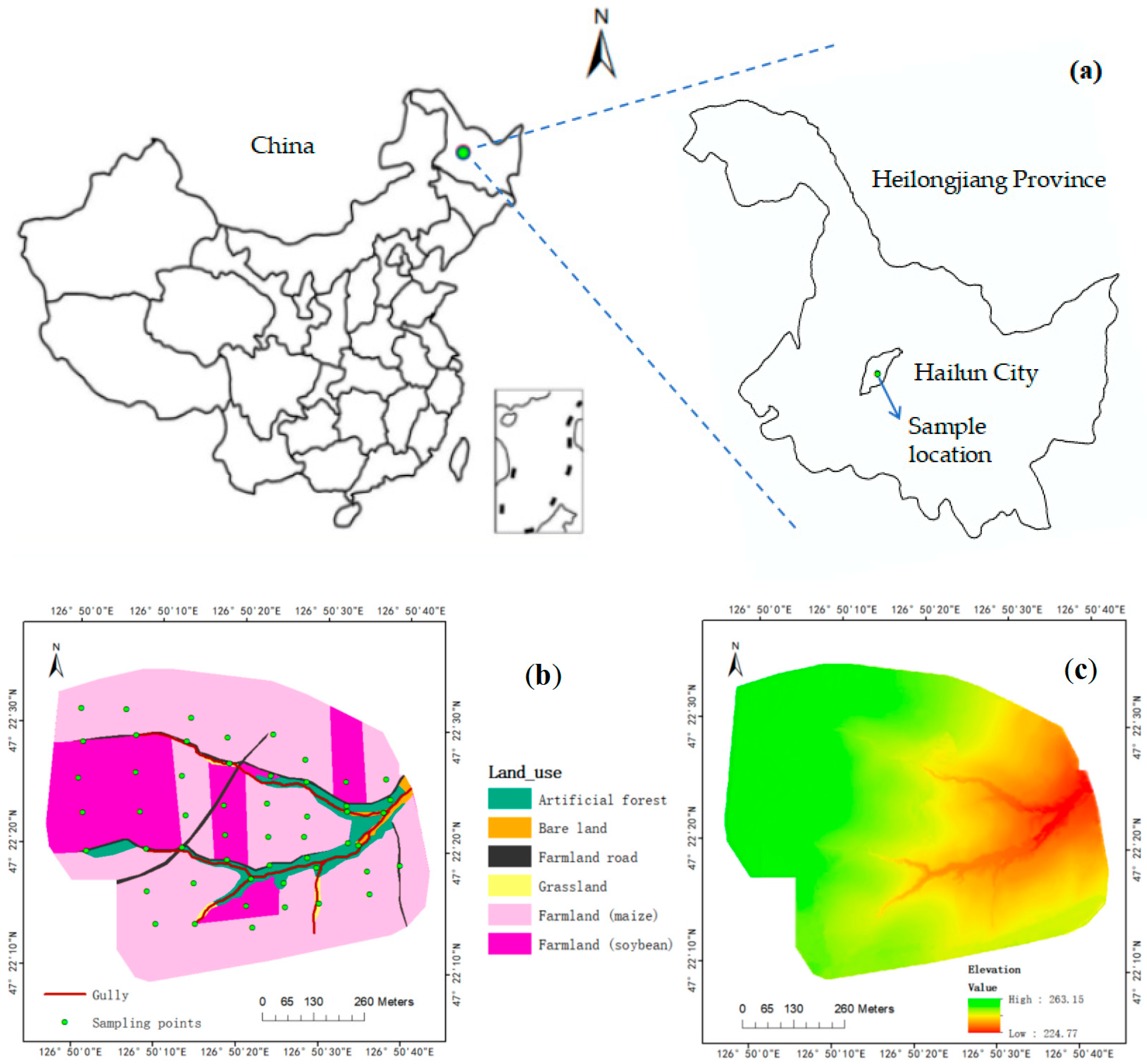
Figure 1. Location of the study area in Heilongjiang Province, China (a), land use types (b) and elevation (c) of the micro-catchment.
Sustainability 15 06355 g001
Figure 2. Distribution of soil organic carbon (a) and total nitrogen (b) in the micro-catchment.
Sustainability 15 06355 g002
Figure 3. Distribution of soil bulk density (a), water content (b), and clay content (c) in the micro-catchment.
Sustainability 15 06355 g003
Figure 4. Spatial distribution for different soil aggregate size fractions in the micro-catchment. Notes: (a), >2 mm size fractions; (b), 0.25–2 mm size fractions; (c), 0.053–0.25 mm size fractions; (d), <0.053 mm size fractions.
Sustainability 15 06355 g004
Table 1. Descriptive statistics for soil organic carbon (SOC) and total nitrogen (STN).
VariablenMax.
(g/kg)
Min.
(g/kg)
Mean
(g/kg)
Standard DeviationCV
(%)
KurtosisSpatial Pattern
SOC5241.1913.3725.687.6929.93−0.81normal
STN523.031.101.960.5528.05−0.95normal
Table 2. Semi-variogram parameters for soil organic carbon (SOC) and total nitrogen (STN).
VariablenModelC0/(C0 + C)R2A (m)
SOC52Spherical0.00230.60748.100
STN52Gaussian0.00040.67339.837
Table 3. Correlation analysis between soil organic carbon (SOC), total nitrogen (STN), and soil physical properties.
VariableBulk DensityWater ContentClayAggregate Size (mm)
>20.25–20.053–0.25<0.053
SOC−0.2310.359 **0.0490.350 *0.023−0.180−0.423 **
STN−0.2130.331 *0.0280.388 **0.014−0.202−0.441 **
Note: * and ** represent the significant levels of 0.05 and 0.01, respectively.
Table 4. Correlation analysis of soil organic carbon (SOC), total nitrogen (STN), and topographic factors.
VariableElevationSlopeAspectCurvature
SOC0.562 **−0.0150.0790.174
STN0.521 **0.0380.0450.230
Note: ** represent the significant levels of 0.01.
Table 5. Distribution characteristics of soil organic carbon (SOC) and total nitrogen (STN) under different land use and management systems.
VariableFarmland (Maize) Artificial Forest Grassland
nRange
(g/kg)
Mean
(g/kg)
nRange
(g/kg)
Mean
(g/kg)
nRange
(g/kg)
Mean
(g/kg)
SOC2013.96–36.2025.06814.34–39.6825.97316.62–37.0827.28
STN201.17–2.681.8981.10–2.891.9931.33–3.022.19
VariableFarmland (Soybean) Bare Land Farmland Road Edge
nRange
(g/kg)
Mean
(g/kg)
nRange
(g/kg)
Mean
(g/kg)
nRange
(g/kg)
Mean
(g/kg)
SOC1013.37–38.3727.58313.37–17.0214.83817.47–49.1928.03
STN101.11–2.772.0931.10–1.191.1481.41–3.032.14
Disclaimer/Publisher’s Note: The statements, opinions and data contained in all publications are solely those of the individual author(s) and contributor(s) and not of MDPI and/or the editor(s). MDPI and/or the editor(s) disclaim responsibility for any injury to people or property resulting from any ideas, methods, instructions or products referred to in the content.