Abstract
Rapid urbanization in China has intensified spatial and social disparities between urban and rural areas, posing major challenges to sustainable rural development. Traditional top-down rural construction and evaluation models often neglect villagers’ everyday practices, resulting in mismatches between spatial planning and actual use. This study develops a cross-scale, bottom-up framework for assessing rural construction through social network analysis (SNA), taking Xiongfan Village in Dawu County, Hubei Province, as a case study. At the village scale, the comparison between the “Public Space Structure Network” and the “Villagers’ Space Usage Behavior Network” reveals a significant mismatch between spatial compactness and behavioral dispersion, with high-frequency activities concentrated along the north–south axis while peripheral and east–west spaces remain underutilized. At the township scale, GPS-based analysis shows that the revitalization of Xiongfan transformed it from a peripheral node into a central hub, restructuring the network into a new pattern of “characteristic towns—traditional villages—ecological scenic areas.” These findings highlight the dual role of rural construction in both meeting residents’ daily needs and fostering regional integration. The proposed cross-scale SNA framework not only advances methodological tools for evaluating rural construction but also provides practical guidance for inclusive, resilient, and sustainable urban–rural development in line with the UN Sustainable Development Goals (SDGs).
1. Introduction
The rapid process of urbanization has driven regional economic growth but also triggered several challenges in rural areas, including population outflow, aging populations, and resource wastage [1,2]. Rural decline has thus become a pervasive global issue [3]. The United Nations Sustainable Development Goals (SDGs) have established a global consensus on the importance of “building inclusive, safe, resilient, and sustainable cities and human settlements,” emphasizing the need for sustainable urban and rural spatial environments and community development [4]. As the world’s largest developing country, China faces significant obstacles to rural sustainable development, exacerbated by unregulated urban expansion [5].
Since China′s reform and opening-up in 1978, rapid urbanization and dual urban–rural policies have widened the development gap between cities and countryside, leading to rural challenges such as population outflow and “hollowing out” [5,6,7]. In response, national strategies like rural revitalization and urban–rural integration have been implemented, categorizing villages to guide targeted development [8,9,10,11]. Suburban-integrated villages, in particular, are expected to balance rural characteristics with urban connectivity, serving both villagers’ daily needs and broader regional integration [12,13,14]. However, the prevailing top-down construction and evaluation models often neglect villagers’ everyday practices, resulting in spatial-behavioral mismatches and limiting the effectiveness of integration efforts [15,16,17]. Consequently, there is a pressing need to assess the spatial outcomes of rural construction projects like the one in Xiongfan Village, not only in meeting internal needs but also in fostering external regional linkages—a gap this study aims to fill. The long-standing “top-down” approach to rural construction, management, and evaluation has stymied regional development and hindered the potential for high-quality urban–rural integration [17]. As a result, the effectiveness of urban–rural integration remains a critical issue in academic research.
Numerous urban–rural integration projects have been implemented in rural areas, such as Xiongfan Village in Dawu County. These initiatives have made preliminary progress in rural development, primarily focusing on public space construction and cultural tourism development to enhance the external appeal of rural areas. However, there is a pressing need to assess the spatial achievements of such projects, identify shortcomings, and explore opportunities for activating cultural tourism. This study aims to fill this gap by applying social network analysis (SNA) to Xiongfan Village, examining both village-level and town-level perspectives to provide a framework for the spatial development of suburban–rural integrated villages. Specifically, this study addresses two core research questions: (1) How do public space construction and villagers’ usage behaviors match at the village scale? (2) How does rural construction influence the sightseeing behavior network at the township scale?
2. Literature Review
In recent years, disciplines such as geography, planning, and management have proposed various theoretical methods for evaluating the effectiveness of rural construction. These include public satisfaction surveys on rural infrastructure construction [18], sustainable assessments of rural architectural environments [19], evaluations of rural road construction plans [20], and assessments of township community vitality [21]. Many scholars have observed that rural areas are not only the fundamental spatial units for villagers’ daily production and activities but also complex social systems where human and natural elements interact [5,22,23]. Consequently, the academic community has turned to systematic and comprehensive social networks as effective tools for evaluating the success of rural construction. These evaluations are typically framed at two scales: the village-level and the town-level.
2.1. Application of Social Network Analysis at the “Village-Level” Scale in Rural Construction Evaluation
Social network theory began to take shape between the 1930s and 1950s. Influenced by quantitative methodologies, it gradually developed into a structured analytical framework, becoming an important theoretical and methodological tool in sociology by the 1990s [24]. Social network analysis (SNA) is capable of uncovering the underlying structures between entities and revealing the network patterns embedded within complex social systems [25]. It offers a fresh perspective for describing and studying social structures and resolving complex problems, gradually becoming an effective framework for studying individual relationships, information dissemination, and resource flows [26,27].
Some scholars have focused on exploring the rationality of rural public space and facility construction from a spatial perspective. Rural public spaces serve as vital venues for villagers’ daily activities, characterized by openness, naturalness, and strong social interactions [28]. However, rural construction often adopts top-down urban planning models that neglect villagers’ everyday practices [29]. When villagers are treated solely as “users” rather than “designers,” the vitality of rural public spaces diminishes [30], and the constructed spaces may fail to meet villagers’ actual needs [31].
Building on this, Yang Chen et al. conducted a quantitative assessment of public facility renewal in township communities by comparing three-tier indicators of social networks (“whole-part-individual”), demonstrating that the spatial attributes of public facility locations influence the social interactions of residents [32]. Similarly, Ding Jinhua et al. quantified the structural characteristics of rural social network models and examined whether the outcomes of micro-upgrades in tourism-oriented rural public spaces meet villagers’ needs, focusing on elements such as public space layout, traffic flow adjustments, and spatial ambiance creation [33]. Wei Ping et al. further categorized precise optimization methods for rural public spaces into two models—”space–behavior” and “settlement-area-point”—and proposed strategies for rural construction, including settlement layout optimization, area faction improvement, and point quality enhancement [34].
Other scholars have expanded on this by comparing the spatial structure networks of similar rural areas, such as exploring the status of shared spaces in clan-based traditional villages or analyzing the public environment renewal of traditional villages in the same region [35,36]. These studies remain primarily within the spatial-dimensional framework. In these works, scholars treat public spaces and facilities as “nodes” in social network analysis, with pathways and distances serving as “links” that form rural spatial networks. These networks are then compared with villagers’ and tourists’ spatial usage behaviors. By analyzing network density, small-world properties, local cliques, and individual centrality, these studies assess the effectiveness of rural construction.
Some researchers have further examined the interaction between the structure of public spaces and social relationship networks. For instance, Gaorui Lin et al. found that social factors, such as spatial location, religious beliefs, and ethnic culture, influence villagers’ spatial usage behaviors [22]. Yuke Chen et al. emphasized that, shaped by traditional cultural customs, villagers tend to choose public spaces that are organically integrated with their living environments and hold significant historical and cultural value [37]. Qin He et al. linked social relations to spatial construction, exploring the spatial adaptation processes and characteristics driven by kinship ties, occupational relationships, and geographical networks, proposing a collaborative governance framework based on “kinship anchoring, occupational cluster regeneration, and geographical path renewal” [38]. These studies have broadened the scope of spatial research in planning, highlighting the interaction and mutual development between social networks and spatial places. Social network theory and its analytical methods provide not only quantitative tools for exploring the internal spatial structure of villages but also guidance for implementing rural construction plans through spatial form analysis [22].
The studies discussed above focus either on the spatial dimension, where social networks are used to establish and directly examine spatial relationship models, or on the social dimension, analyzing the correlation between social structures and physical spaces. Both approaches start from the micro-scale of the village itself to assess the effectiveness of rural public space construction. However, applying social network research within the village context only compares the compatibility of rural public spaces, infrastructure networks, and villagers’ usage behaviors at a micro level. Suburban–rural integrated villages must not only address the daily needs of villagers but also enhance external attractiveness, promoting urban–rural integration and development [14,39,40,41]. To better address the dual construction tasks of such villages and evaluate the effectiveness of suburban–rural integrated village construction, it is essential to investigate the impact of rural construction on external attractiveness in the context of urban–rural integration, an area that remains underexplored in existing research.
2.2. Application of Social Network Analysis at the “Township” Scale in Rural Construction Evaluation
Suburban–rural integrated villages must not only meet villagers’ basic needs for public facilities and services, such as housing and transportation, but also facilitate interaction and integration between villages and towns. This promotes integrated village–town development, enabling the sharing of resources and complementary advantages [42]. Some scholars have examined rural construction in the context of urban–rural integration through social network analysis [7]. For example, Qiaobing Yue et al. considered residential points as nodes and interactions between townships, triggered by differences in public facility spaces, as edges. They constructed a potential inter-town network and identified three types of rural areas: urban-leading, urban–rural integration, and rural-leading areas [43]. Jiaxing Cui et al. used population and economic data to build an interconnected network within the urban–rural system and proposed development strategies based on primary and secondary central towns in the network [44]. Yahuan Cai et al. applied social network analysis along with an improved gravity model to measure the strength of connections between villages within a township, classifying village clusters based on network indicators, and suggesting development strategies based on urban–rural cluster integration [45]. Quanyu Liu et al. revealed a distinct “core–periphery” structure between towns and villages and proposed revitalization strategies, such as upgrading facility networks, fostering industrial synergy, and integrating cultural landscapes, to facilitate the flow of population and industrial elements between urban and rural areas [46].
From these studies, it is evident that administrative boundaries (such as counties, towns, and villages) are not only geographical divisions but also reflect disparities in space, power, organization, and policy resources [47]. These studies have explored the spatial layout, hierarchical division, and strength of connections between villages and towns at the macro level, providing theoretical support for coordinated urban–rural development. However, existing studies have largely overlooked the dynamic disruptions caused by specific construction projects within regional networks. Furthermore, their measurement indicators often rely on macro-level data such as economic indicators, infrastructure, or population, neglecting individual behavior and local practice contexts.
2.3. Synthesizing the Cross-Scale Logic
In summary, the existing social network analysis (SNA) of rural construction outcomes clearly distinguishes between micro- and macro-level scales. Micro-level research focuses on internal village dynamics, offering a precise identification of mismatches between public spaces and villagers’ behaviors. However, it fails to address the strategic goal of enhancing external attractiveness in urban–rural integrated villages. On the other hand, macro-level research depicts the structural framework of village–town systems but often relies on “static data” such as economic indicators, infrastructure, or population size as network weights, missing a human-centered perspective and failing to measure the dynamic impact of individual rural construction projects on regional networks. This study aims to analyze the specific issues related to existing public spaces in the village by comparing the Public Space Structure Network with villagers’ spatial usage behavior networks (including daily labor, social interaction, and leisure activities such as walking) at both the village and township scales. Additionally, this study will further construct and compare the characteristics of tourist sightseeing behavior networks within the township before and after rural construction (including travel behaviors such as tourism and cycling), exploring the effectiveness of suburban-integrated rural construction from a “bottom-up” perspective. The primary focus is whether the layout of public space after rural construction aligns with villagers’ spatial usage behaviors and how such rural construction influences sightseeing behavior networks within the township.
The logical chain connecting suburban integration, public space construction, and regional development can be summarized as follows: suburban-integrated villages are tasked with a dual mission. Internally, well-designed public spaces that match villagers’ behavioral patterns enhance daily livability and social vitality. Externally, these activated spaces, particularly those with cultural and scenic value, become attractive nodes for tourists. When these village nodes are effectively connected through transportation and sightseeing routes, they reshape the township-level network, transforming the village from a peripheral entity into a central hub that fosters resource sharing and industrial complementarity, thereby achieving the broader goal of urban–rural integration [15,42,48,49]. This study’s cross-scale SNA framework is designed explicitly to capture this entire logical chain, from internal spatial effectiveness to external network integration.
The ‘cross-scale social network analysis’ employed in this study refers to the simultaneous application of SNA at both the village and township levels to assess rural construction. Its scientific rationale is threefold: (1) It acknowledges that rural sustainability is influenced by processes operating at multiple, interconnected scales; (2) It allows for the quantification of both the internal functionality of a village (space–behavior match) and its external connectivity (regional integration); (3) It provides a replicable, data-driven framework that moves beyond top-down assessments by grounding the analysis in the actual behaviors of residents and tourists, thereby offering a genuinely bottom-up perspective on development outcomes.
3. Research Design
3.1. Research Area
To address the research questions, the team investigated the current state of suburban–rural integrated rural construction. Geographically and economically, China can be broadly divided into three regions: the eastern, central, and western regions. The eastern region benefits from inherent locational advantages, policy support, and capital accessibility, with urban–rural integration being relatively well-developed. In contrast, the western region faces challenges due to natural conditions such as terrain and topography, and its development lags behind the national average. Many areas in this region continue to focus on consolidating poverty alleviation achievements. The central region, however, has experienced the most significant growth in urban–rural integration, with its integration index increasing from 0.42 in 2012 to 0.64 in 2022, reflecting an average annual growth rate of 4.18% [50]. This substantial improvement indicates that the region has made notable progress in urban–rural integration, largely driven by policy initiatives.
Dawu County, located in Xiaogan City, Hubei Province, lies within the central region and ranks at an intermediate level in terms of both industrial economy and living environment development. The rural construction in this area represents a typical example of the phased development of urban–rural integration. Huangzhan Town, in particular, serves as a “typical” town in the northern part of Hubei Province for urban–rural integration. It is well-connected to Xiaogan City and Wuhan City through its transportation network. The town began its urban–rural development initiatives in 2019, making it one of the first in the county to do so. Xiongfan Village, located within Huangzhan Town, serves as a model of a traditional village in Hubei Province. The village was included in the fifth batch of China′s Traditional Village List in June 2019 and houses the only municipal-level cultural relic protection unit in the town.
Xiongfan Village consists of 12 villager groups, 6 natural hamlets, and 474 households, covering a rural community spanning 4 square kilometers. Despite its rich historical resources and cultural heritage, the village is facing significant challenges, including rural “hollowing out.” The village suffers from insufficient internal development momentum, with the permanent resident population representing only one-third of the registered population. Furthermore, the village has been slow to develop rural industries. However, Xiongfan’s proximity—just 2.1 km—from the central town places it within a suburban integration-type rural area, as defined in the master plan. Therefore, revitalizing and utilizing the traditional rural resources in the village to promote coordinated development between the village and its neighboring town has become a primary focus of the ongoing construction efforts.
In December 2021, the village initiated a series of rural construction projects, including the development of public spaces, restoration of ancient buildings, residential renovations, and participatory activities, with the goal of promoting comprehensive rural development through cultural and tourism initiatives. As of now, several spatial construction tasks have been preliminarily completed (Figure 1), providing the material foundation for future resource investments. Despite these advancements, a survey conducted by the village’s collective work report revealed that 46% of public spaces received low satisfaction ratings from villagers. Additionally, in 2024, the village’s collective income remained below CNY 100,000, significantly lower than the county average, and cultural tourism has yet to generate a substantial increase in the village’s collective income. In response to these challenges, it is crucial for rural construction practitioners to assess the effectiveness of the ongoing rural construction initiatives in Xiongfan Village since 2021.
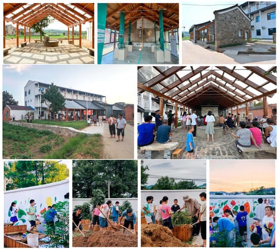
Figure 1.
Rural construction process and partial achievements in Xiongfan Village.
3.2. Research Methods
- Step 1: Data Collection
The initial phase of this study involved the selection of the study area and subsequent data collection from the village network in the main residential zones of Xiongfan Village. Field surveys were conducted by the research team in May 2024 to identify rural public spaces. Aerial photography and interviews with local residents were utilized to identify 62 frequently used public space nodes in the village. The coordinates and actual distances of these spaces were recorded using ArcGIS (10.8).
- Step 2: Classification of Rural Public Spaces
Public spaces in Xiongfan Village were classified into several categories based on the classification scheme of Xiaoyun Li et al. These include historical relics, villager-built structures, government-repaired facilities, and spaces managed by social organizations. The public spaces in the village were categorized into five primary types: living-type, recreational-type, organizational-type, event-type, and project-type spaces [51]. An additional category, agricultural production-type public spaces, was included based on local conditions. This classification resulted in a total of six categories, encompassing 62 public spaces within the village (Table A1 and Figure 2). The road distance between any two points was calculated using the “New Closest Facility” tool in ArcGIS (10.8). Research indicates that a 300 m walking distance is ideal for rural areas, as it represents a 3–5 min walk—a widely accepted threshold for comfortable pedestrian access in rural settings [52]. This distance ensures moderate physical exertion, particularly suitable for elderly residents who constitute a significant portion of the village population, while encouraging frequent use of public spaces. In this study, nodes that were connected by a direct path within 300 m were considered linked, while those beyond this threshold were deemed disconnected. A facility-point connection matrix based on spatial distance was generated, forming the village-level “Public Space Structure Network” (Na).
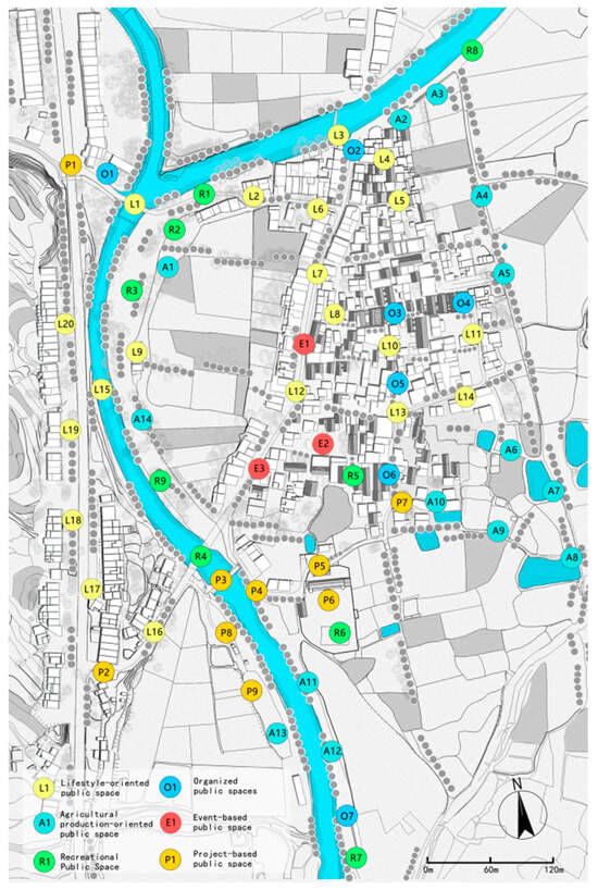
Figure 2.
Types and distribution of public spaces within the village network.
- Step 3: Behavioral Survey of Villagers
Following the identification and classification of public spaces, a comprehensive door-to-door survey was conducted between June and October 2024. We targeted 210 permanent residents, selected via stratified random sampling based on age and household location to ensure a representative sample of the village population. Participants were provided with a detailed base map of the village and were instructed to draw their frequent daily movement trajectories and mark stop points for a typical week, covering activities such as daily labor, social interaction, and leisure. A total of 198 valid maps were collected (94.3% response rate). The trajectory and stop-point data were then digitized and georeferenced in ArcGIS (10.8). The daily activity paths were overlaid, with each segment assigned a weight corresponding to the frequency it was traversed across all respondents. This generated a spatial connection matrix based on the residents’ collective behavior, which was subsequently used to create the “Villagers’ Space Usage Behavior Network” (Na′).
- Step 4: GPS Trajectory Data Collection
Due to the limitation of hand-drawn maps for capturing travel trajectories within the township area, GPS trajectory data were gathered from the “2bulu” and “Foooooot” platforms, which are designed to record users’ travel routes via GPS and support offline data storage and community sharing. To ensure the data relevance for analyzing tourism and sightseeing mobility, we manually screened and retained only trajectories explicitly tagged with purposes such as “hiking,” “cycling,” and “self-driving tours.” This purposeful sampling strategy effectively focuses the analysis on recreational travel behaviors, which are central to our research questions. The screened trajectories were further validated through our field surveys to confirm their alignment with actual travel patterns in the region. The network generation algorithm used the “Overlay Analysis—Intersection” tool in ArcGIS (10.8) to create a two-mode network from trajectory data and village/town boundaries, which was then converted to a one-mode village-to-village network using the “Network Analysis” module, with connection strength calculated based on the frequency of trajectory crossings between adjacent villages. These platforms are widely used in research on user travel behavior [53,54]. The study collected trajectory data spanning the town’s administrative area, organized by time periods, and labeled data representing travel activities such as “tourism” or “sightseeing.” Although 389 data points from vehicles and bicycles were collected from 2018 to 2024, the walking distances were deemed insufficient to assess village–town interaction. As a result, these walking data points were excluded. Ultimately, 779 valid GPS data points were compiled and integrated into the village–town boundary map. Based on the actual start year of rural construction in Xiongfan Village, the GPS trajectory data were divided by time segments, using 2021 as the cutoff year, and imported into ArcGIS (10.8). Using the “Overlay Analysis—Intersection” tool, a two-mode network (nm) was created from the trajectory data (n) and village/town data (m). Subsequently, a one-dimensional network (m*m) was generated by converting the two-dimensional network using ArcGIS (10.8) network analysis tools, with villages represented as “points” in the “Township Network,” and the number of trajectory crossings between villages denoted as “lines” in the network. This process produced the “Township Construction Network” (Nb, 2021–2024) and the “Township Original Network” (Nb′, 2018–2021). Finally, the network was visualized using Gephi (0.10), where the size of the circles indicates township centrality in the respective networks, and the line width represents the communication connectivity between township nodes.
- Step 5: Network Analysis
To analyze the “village–town” dual-layer rural construction network (Figure 3), the Ucinet (6.8) network analysis tool was used. The overall characteristics, local clique relationships, and individual centrality of both networks were calculated, following common metrics in social network analysis [32,34,55,56,57].
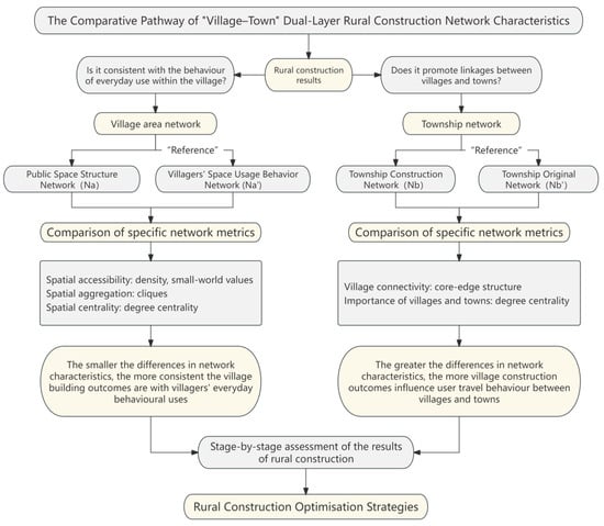
Figure 3.
Technical approach for analyzing the “village–town” dual-layer rural construction network.
The overall characteristics of the networks were assessed through association analysis and connectivity analysis. Network association was evaluated using network density, while network connectivity was measured using the clustering coefficient and average path length metrics, reflecting the small-world properties of the network [22].
Network density is a core metric that measures the closeness of connections between nodes. It reflects the efficiency of information, resource, or influence flow within the network, and is calculated using the formula:
where E represents the number of actual edges, and N is the total number of nodes.
The clustering coefficient measures the compactness of local neighborhoods within the network. The clustering coefficient for a node is calculated using:
where ei is the number of edges between neighbors of node i, and ki is the degree of node i.
Average path length reflects the overall efficiency of the network, with shorter paths indicating greater connectivity. It is computed as:
where dij is the shortest path length between nodes i and j.
The small-world property of a network is determined by the clustering coefficient C and average path length L. A network is considered to exhibit small-world characteristics if:
where Crand and Lrand are the clustering coefficient and average path length of a random network, respectively. If σ > 1, the network exhibits small-world features [58].
To assess the local structure, the concept of cohesive subgroups was applied. A clique, as a special type of cohesive subgroup, is the largest complete subset of nodes where every pair of nodes is directly connected [59]. The conditions for a clique are:
Individual centrality is an important aspect of network analysis, with degree centrality used to measure node importance [60]. It effectively reflects a node’s activity and connectivity within the network and provides insights into the distribution of nodes in the network [22]. Degree centrality reflects the number of direct connections a node has, and is calculated as:
where C′D(i) is the absolute degree centrality of node i (the number of directly connected nodes), N is the total number of nodes in the network, and N − 1 is the maximum possible number of connections.
To assess the influence of Xiongfan Village as a single node in the network, the “core–periphery” structure was analyzed. This method identifies differences in node centrality by distinguishing between core (high-density) and peripheral (low-density) nodes [61]. Within social network analysis, the “core–periphery” structure model dichotomizes nodes to reveal centrality disparities, with the objective of maximizing connection density within the core and minimizing it within the periphery [62]. The formula for identifying the core–periphery structure is:
where A = [aij] denotes the adjacency matrix of the observed network. D = [dij] is the ideal core–periphery matrix, where nodes assigned to the core (ci = 1) are expected to connect with all other nodes, while peripheral nodes (ci = 0) have no ties among themselves. The coefficient ρ represents the correlation between the upper-triangle elements of A and D, measuring the extent to which the observed network conforms to an idealized core–periphery structure. A higher value of ρ indicates a stronger core–periphery pattern.
4. Results
4.1. Matching Analysis Between Public Space Construction and Villagers’ Behavior at the Village Scale
In the “Public Space Structure Network” (Na, Figure 4a), the circle size corresponds to the degree centrality of each public space node within the spatial configuration network, indicating its potential accessibility based on physical connections. The line width represents the actual pathway connectivity between spaces, with thicker lines denoting stronger spatial linkages. In contrast, the “Villagers’ Space Usage Behavior Network” (Na′, Figure 4b) visualizes observed behavioral patterns: circle size indicates the frequency of usage (behavioral centrality), while line width shows the strength of behavioral connections based on residents’ actual movement between spaces. Similarly, in the “Villagers’ Space Usage Behavior Network” (Na′), the circle size indicates the centrality of public spaces in relation to villagers’ behavior, and the line width denotes the connectivity between spaces based on actual usage by villagers (Figure 4).
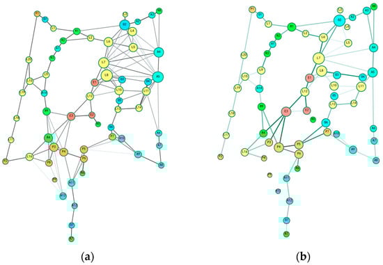
Figure 4.
Comparison of public space networks in Xiongfan Village: (a) “Public Space Structure Network” (Na); (b) “Villagers’ Space Usage Behavior Network” (Na′).
4.1.1. Overall Feature Comparison
The calculations reveal that the network density of Na is 0.067, significantly higher than that of Na′ (0.227), indicating stronger connectivity of public spaces in terms of geography and pathways. The clustering coefficient of Na is 0.543, substantially greater than that of Na′ (0.227), suggesting that public spaces tend to form more localized clusters structurally, whereas villagers’ actual usage behavior is more dispersed and discontinuous.
Moreover, the average path length of Na is 4.445, which is shorter than that of Na′ (5.655) (Table 1). This further implies that villagers tend to engage in detouring, avoidance, or interruption behaviors during actual use, leading to longer behavioral paths and decreased network efficiency. The structural mismatch between “spatial compactness and behavioral dispersion” highlights the issue that some public spaces, while accessible, remain underutilized, existing in proximity but not actively chosen for use.

Table 1.
Comparison of overall characteristics of the village network.
The results indicate that the “Public Space Structure Network” (Na) outperforms the “Villagers’ Space Usage Behavior Network” (Na′) in terms of connectivity, clustering, and connection efficiency. While the spatial structure of the Xiongfan network is relatively compact and highly connected, villagers’ actual use of these spaces is influenced by factors such as distance, social interaction needs, and transportation conditions. This results in a more loosely structured behavioral network. Consequently, villagers’ behavior is characterized by detours, avoidance, or interruptions, leading to longer travel paths and reduced network efficiency.
For example, in the “Villagers’ Space Usage Behavior Network” (Na′), individual public space nodes show distinct “breaks.” Government-invested project-based spaces, such as P2 (South Village Gate Archway), P8 (West River Embankment), and P9 (Parking Lot), as well as life-related spaces like L4-7 (Front Yard) and L8 (Ancient Well), are notably disconnected. This fragmentation is attributed to frequent mixed pedestrian and vehicle traffic along connecting paths, as well as damage to certain spaces, which impedes residents’ movement. Additionally, the rural area has a high proportion of elderly residents, who tend to favor paths with less vehicular traffic, better visibility, and higher accessibility, even if it means longer walking distances.
For instance, the fragmentation in the behavioral network is particularly evident at nodes P2 (South Village Gate Archway) and P8 (West River Embankment), which show significantly lower connectivity in Na′ compared to Na (Figure 4). These nodes, despite their structural accessibility, are avoided due to persistent construction activities and mixed pedestrian-vehicle traffic conflicts, as observed during field surveys. Similarly, L4 (Qiandian Vacant Land) and L10 (Former Site of the Hospital) exhibit behavioral avoidance patterns attributable to their narrow alleyways and lack of amenities, highlighting the mismatch between spatial design and actual usage. Meanwhile, socio-cultural routines, such as gathering at specific shops (L12) or spaces traditionally used for social exchange (e.g., around the ancient well L8), also shape movement patterns, leading to behavioral clusters that may not align with the most spatially compact routes.
4.1.2. Local Feature Comparison
In a spatial network, factions represent clusters of public space nodes that are closely interconnected, emphasizing key local areas within the network’s structure. In behavioral network models, factions denote groupings formed by villagers’ activities across public space nodes, highlighting regional hotspots where villagers’ behavioral activities are concentrated.
Clique analysis revealed that 18 local cliques were formed in Na, whereas only 14 remained in Na′ (Table 2), with a notable reduction in size, most of which consisted of small groups of three nodes. This suggests that the range of villagers’ activities is limited. Spatially, these cliques are predominantly concentrated in the northern part of the main street, the Jiuchong Ancient House residential area, and the southern end of the river.
Table 2.
Clique characteristics of village networks.
A comparison of the clique characteristics between the two networks showed that, aside from the cliques that remained unchanged in both networks, some cliques completely disappeared in Na′, while others experienced individual node replacements (Figure 5). These cliques display distinct underlying factors and characteristics. The factions that completely disappeared in Na′ are factions 4, 5, 10, 11, and 15. The factions that underwent partial node replacements in Na′ are factions 1, 3, 7, 13, 14, 16, and 17.
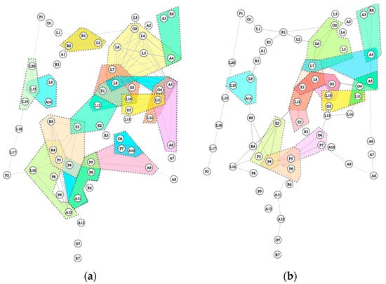
Figure 5.
Comparative analysis of local cliques within the public space network of Xiongfan Village: (a) “Public Space Structure Network” (Na); (b) “Villagers’ Space Usage Behavior Network” (Na′).
Three results obtained by comparing two groups of network factions (Figure 6). In terms of disappearing factions: 4 groups (L8 (Ancient Well)—A5 (Qianwan Field Embankment)—O4 (Jiuchong Ancient House Square)) have completely disappeared. This cluster suffers from issues of isolation and narrow spaces, resulting in poor quality of internal circulation; 5 groups (L2 (North Alley Front Yard)—R1 (Riverfront Square)—R2 (Basketball Court)) have disappeared, primarily due to insufficient attractiveness of path spaces and aging facilities; 10 groups of L15 (“Shoulder pole” bridge) and L19 (New Residence Front Yard)—L20 (Bus Stop) have disappeared. The Flat-Rod Bridge is separated from the surrounding residential front yards by a provincial highway and is relatively distant, resulting in poor connectivity; 11 groups of L16 (South Village Entrance Front Yard)—A13 (West River Threshing Floor)—R4 (Old Bridge Entrance)—P3 (Rolling Dam)—P8 (West River Embankment) have disappeared. This route has frequent mixed traffic of pedestrians and vehicles and has been under construction for an extended period, resulting in low safety standards; Group 15: A11 (East River Field Ridges)—P4 (East River Embankment)—P6 (Elementary School Renovation Site) has been removed. A11 has been replaced by P5 (Village History Museum). Since the original road repairs have not been completed, and the facilities along the river and around the Village History Museum and elementary school are more complete, the landscape is more appealing, and it is more likely to be chosen by villagers.
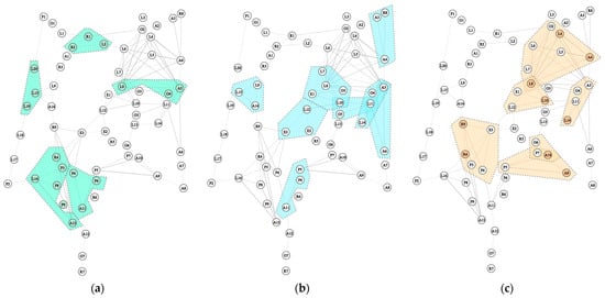
Figure 6.
Local cliques comparison results: (a) Cliques where Na completely disappears in Na′; (b) Cliques where Na undergoes node replacement in Na′; (c) Cliques where Na is retained in Na′.
In terms of node replacement within factions: In Group 1, L4 (Qiandian Vacant Land), L8 (Ancient Well), and A4 (Intersection of Field Ridges) were not mentioned. This area lacks recreational facilities and has a relatively monotonous spatial layout; In Group 3, L10 (Former Site of the Hospital) was not mentioned, as it is located in a narrow alley east–west of the ancient willow tree, resulting in a closed-off space; In Group 7, L14 (Ancient Willow Tree House Front Open Space) was not mentioned, as the development along the Nine-Story House lacks radiating effects; its influence range could be appropriately extended in the future; A9 (Eighth Group of Threshing Field) and A10 (Eighth Group of Ponds) in Groups 13 and 14 have been replaced by P5 (Village History Museum). The enhanced appeal of the village history museum has relatively weakened the appeal of A9 and A10. Their influence can be extended further into the fields by leveraging the radiation effect of O6 (Xuanrong Ruiying Ancient House) and P7 (Renovation Square) toward the Group 8 square; The section from R4 to R9 in Group 17 has not been mentioned. This section is relatively distant from the cluster formed by E3 (Wedding and Funeral Ceremony Gathering Place)—P3 (Rolling Dam)—P4 (East River Embankment), so extending the connecting path could be considered.
4.1.3. Degree Centrality
From the perspective of node centrality, the top 10 nodes in the “Public Space Structure Network” (Na) do not overlap with the top 10 nodes in the “Villagers’ Space Usage Behavior Network” (Na′) (Table 3). The former reflects the relative “center-periphery” relationship of facility points in terms of geographical location, while the latter highlights the gathering places that attract people and are truly engaging to community residents in daily life. By comparing the two networks, nodes that are generally accessible in the spatial network Na but show significantly higher villager activity in the behavioral network Na′ were identified.
Table 3.
Comparison of individual centrality in village-level networks.
A comparative study of centrality metrics between the “Public Space Structure Network” and the “Villagers’ Space Usage Behavior Network”, using social network analysis methods, reveals significant differences in the spatial node centrality distributions of the two networks.
In the spatial network analysis, core nodes with high centrality exhibit a multipolar distribution pattern. Among these, L8 (Ancient Well), A4 (Intersection of Field Ridges), and A5 (Qianwan Field Embankment) form the most accessible triangular core area, with their degree centrality indicators reaching peak values. Secondary hub nodes are linearly distributed along the main street corridor, including key spatial interfaces such as O2 (Riverbank Shrine), L6 (North Village Entrance Residential Area Open Space), L7 (Alleyway Entrance Front Yard), and P3 (Rolling Dam), creating a “one axis, multiple cores” topological structure.
In contrast to the dispersed spatial layout of the spatial network, the behavioral network’s centrality indicators reveal a pronounced spatial polarization. High-frequency activity nodes are concentrated along the continuous corridor formed by O2-L6-L7-E1-L12-E3 (main street nodes), with E1 and E3 (Wedding and Funeral Ceremony Gathering Place) serving as community-oriented composite spaces. These nodes leverage their central location and spatial flexibility to host periodic folk activities while maintaining daily social functions. The open spaces in front of residential buildings, such as L6, L7, and L12 (Small Shops), have been transformed from passageways into gathering spaces by adding resting facilities and commercial functions. Notably, P4 (East River Embankment) and the newly constructed cultural facilities, P5 (Village History Museum) and P6 (Elementary School Renovation Site), have enhanced node activity. However, end nodes such as P7 (Renovation Square) and O6 (Xuanrong Ruiying Ancient House) show significant spatial discontinuity, highlighting the need for path connections to be completed.
Furthermore, a comparative analysis reveals that the newly constructed forest-shaded leisure walking path system along the Shui River (R2-A1-R3-L9-A14-R9) has significantly increased centrality through environmental upgrades and the integration of new facilities. In contrast, the traditional core area of the village, clustered with ancient residential buildings (specifically the L8-A4-A5 section, from the ancient well to the field ridge), has experienced a decline in centrality. This decline is attributed to several constraints, including physical environmental degradation, insufficient landscape quality and comfort, and deteriorating road connectivity, which exacerbate spatial isolation.
4.2. The Reshaping of Tourist Sightseeing Behavior Networks at the Township Scale
In the “Township Original Network” (Nb′) and the “Township Construction Network” (Nb), the size of the nodes represents the centrality of village and town nodes within the network, while the line width indicates the strength of connections between villages and towns, or between villages, based on actual user travel behavior (Figure 7).
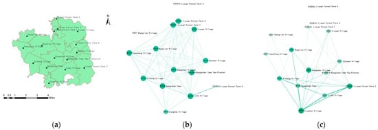
Figure 7.
Township network comparison: (a) Location of towns and villages within the township’; (b) “Township Original Network” (Nb′); (c) “Township Construction Network” (Nb).
4.2.1. Comparison of “Core-Periphery” Structural Characteristics in the Town Domain
In the “Township Original Network” (Nb′), the network core is concentrated around two nodes: Liuhe Village and Liyuan Forest Farm (Table 4). These nodes have formed the sole “tourism corridor” within the township, a result of early investments in ecological tourism resources. Other villages, such as Xiongfan, Tuancong, and Zhangzhai, are situated on the periphery, with sparse connections and weak interactions.
Table 4.
Comparison of the core–periphery structure between the “Township Original Network” (Nb′) and the “Township Construction Network” (Nb).
In the “Township Construction Network” (Nb), the number of core nodes increased from 2 to 3, while the number of peripheral nodes decreased from 11 to 10. The rural construction of Xiongfan has facilitated its quick transition into the core, promoting stronger connectivity between villages and towns within the network. Together with Huangzhan Town and Liuhe Village, Xiongfan now forms an integrated travel and sightseeing route combining “characteristic towns—traditional villages—ecological scenic areas,” creating a new regional resource aggregation area and enhancing Huangzhan’s cultural and tourism appeal. It is noteworthy that Liyuan Forest Farm 2 is classified as a core node in the original township network (Nb′) despite its moderately lower centrality value in Table 5. This apparent discrepancy arises because the core–periphery algorithm optimizes for connection density patterns rather than relying solely on individual centrality metrics [62]. Liyuan Forest Farm 2’s core status reflects its strategic bridging position in the network topology, facilitating connections between otherwise disconnected components, which is captured by the core–periphery model but not fully represented by degree centrality alone.
Table 5.
Comparison of degree centrality between the “Township Construction Network” (Nb) and the “Township Original Network” (Nb′).
As the first green ecological tourism pilot village invested in by Huangzhan Town, Liuhe Village, along with the San Tianmen Scenic Area within the Li Yuanlin Farm, represented the only tourist route in the township before 2021. This structural shift signifies that the development of Xiongfan Village has not only enhanced its position within the town network but has also disrupted the previous “dual-core monopoly,” reinforcing the aggregation effect and accessibility of the town’s tourism resources.
4.2.2. Comparison of Degree Centrality in the Town Network
In the town network, degree centrality reflects the frequency with which nodes are jointly selected by tourism travelers (Table 5). A comparison of the degree centrality rankings between the “Township Original Network” (Nb′, 2018–2021) and the “Township Construction Network” (Nb, 2021–2024) reveals the following key changes:
Following development, Xiongfan Village saw a significant improvement in its degree centrality ranking. In the original network, Xiongfan Village had a degree centrality of 20, ranking 3rd, well below Liuhe Village (49) and Liyuan Forest Farm 2 (30). It was situated on the periphery of the network, primarily relying on a single pathway between Liuhe Village and Liyuan Forest Farm 2 for town-level interactions. In the constructed network, Xiongfan Village rose to first place with a degree centrality of 59, emerging as the “bridge hub” with the highest number of connections in the entire network.
Meanwhile, Huangzhan Town’s degree centrality increased from 19 to 35, while the degree centralities of other peripheral nodes remained within ±5. This indicates that the rise in Xiongfan and the town center has not diminished the importance of existing high-value nodes. Rather, it has enhanced the overall network by establishing new horizontal connections (e.g., Xiongfan–Huangzhan Town, Xiongfan–Xichong Village), thereby expanding the network’s “bandwidth” and reducing reliance on single pathways. This shift provides a solid foundation for the balanced development of cultural tourism across the town.
These changes demonstrate that Xiongfan Village is no longer a “peripheral node” dependent on existing tourism routes, but has transformed into a central “bridge hub” linking Huangzhan Town, Liuhe Village, and surrounding villages. The development of its public spaces has not only addressed the needs of the villagers but also played a crucial role in integrating cultural and tourism resources, as well as guiding routes at the town level.
5. Discussion
5.1. Comparison with Existing Research
Existing studies on rural construction assessment have mainly emphasized infrastructure distribution, public services, or macro-level integration models. For example, Chen et al. [18] and Wan & Ng [19] used satisfaction surveys and sustainability evaluations to assess infrastructure and built environments, while Banick et al. [20] examined rural roads using accessibility models. Similarly, McManus et al. [21] highlighted community vitality as a measure of rural resilience. However, few studies have systematically analyzed how public spaces align with villagers’ behavioral practices.
At the village scale, scholars have investigated public spaces as network nodes to evaluate facility rationality and social interactions [22,32,37]. Ding & Zhang [33] and Wei [34] examined tourism-oriented villages and proposed “space–behavior” optimization strategies. Lin et al. [22] and Chen et al. [37] further emphasized that cultural traditions and social ties shape spatial usage behaviors. Yet these works remain limited to the micro-scale, focusing primarily on spatial–behavioral matching within single villages.
At the township scale, researchers have applied SNA to depict village–town linkages, often relying on economic or population data as network weights. For instance, Yue et al. [43] and Cui et al. [44] constructed inter-town networks based on facility disparities or demographic flows, while Cai et al. [45] classified clusters through improved gravity models. These studies revealed hierarchical structures and “core–periphery” patterns but generally overlooked behavioral dynamics.
Our study extends this literature in two directions. First, by adopting a cross-scale perspective, it bridges village-level “space–behavior” mismatches with township-level tourism and cultural linkages, revealing systemic interactions across scales. Second, it demonstrates empirically that activating a single node (Xiongfan Village) can restructure township-level networks, providing new evidence for “point-driven, area-wide” rural revitalization strategies [16,42]. This dual contribution resonates with recent discussions on sustainable urban–rural integration, which stress not only infrastructure and economic flows but also social interactions and everyday practices as critical to achieving the SDGs [39,63]. Furthermore, while our SNA framework primarily quantifies spatial-behavioral interactions, the results underscore the implicit yet critical role of social and cultural factors in shaping these patterns. The concentration of high-frequency activities around nodes like L12 (Small Store) and E1/E3 (Wedding and Funeral Ceremony Gathering Place) highlights how social interaction and cultural practices dictate spatial usage, resonating with literature that emphasizes kinship, tradition, and daily routines as key influencers [22,37,38]. The observed mismatch, such as the avoidance of the spatially accessible ancient well (L8), may thus stem not only from physical barriers but also from evolving social dynamics or diminished cultural relevance. This suggests that future research could strengthen the SNA approach by explicitly integrating qualitative insights into social and cultural contexts, thereby offering a more holistic understanding of the ‘society–space’ interaction in rural construction.
5.2. Practical Recommendations
At the village scale, the planning of public spaces in Xiongfan Village does not align well with the actual needs of its residents. Despite having a diverse range of public space nodes and strong community aggregation, key cultural assets such as the Nine-Story House, Xuanrong Ruiying, Ancient Willow, and Bai Ci An are underutilized. Additionally, the village’s east–west pathways and peripheral nodes suffer from low usage rates due to physical barriers and missing facilities. To address these issues, the development of Xiongfan’s public space network should be pursued in three ways:
5.2.1. Overall Reinforcement
Prioritize the renovation of the east–west road network to improve horizontal connectivity, enhancing internal transportation and facilitating better communication among residents. Additionally, cultural facilities and rest nodes should be added to connect significant landmarks like Jiuzhong House and Gu Liu, forming a cultural corridor that increases spatial utilization and social interaction.
5.2.2. Local Expansion
Enhance the accessibility of peripheral nodes through closed-loop path design. Activate underutilized spaces by integrating parking lots and commercial facilities, thus expanding the public character of these nodes. This will strengthen local cohesion, drive development in peripheral regions, and reduce disparities with more central areas.
5.2.3. Individual Consolidation
Fully capitalize on the advantages of central nodes, particularly along the main street, by integrating community activities and folk customs. Embedding composite functions at these nodes will enhance their attractiveness and influence, driving the overall development of the village’s public space network.
Although the public space planning in Xiongfan Village requires further refinement, at the township scale, Xiongfan has emerged as a central node in the township’s sightseeing network, with a notable increase in degree centrality. This transformation, through systematic construction, has established a “characteristic township—traditional village—ecological scenic area” linkage pattern with Huangzhan Town and surrounding villages, facilitating the concentrated development of cultural and tourism resources in the region.
However, the radiating effect of this interconnected pattern remains limited, with weak connections between the core node and peripheral nodes like Tuanchong Village and Changlian Village. These weak connections signal a need for future policy interventions, such as improving transportation infrastructure and enhancing industrial complementarity. Further expansion of cultural tourism routes and targeted village-to-village cooperation will be essential to prevent network polarization and foster more balanced development across the township.
5.3. Further Research
Several avenues for further research are suggested. First, this study did not fully account for the differentiated needs of diverse villager groups, such as the elderly, children, or returning youth. Future research could adopt a demographic lens to develop more inclusive and tailored spatial strategies. Second, the relationship between different categories of public spaces (e.g., living-type, production-type, event-type) and corresponding behavioral needs deserves more systematic analysis. Incorporating multi-type trajectory data would refine the “society–space” interaction model. Third, while GPS data proved useful in capturing tourism-related mobility, integrating additional data sources—such as mobile phone signaling, social media check-ins, or ethnographic interviews—would provide a more holistic view of village–town interactions, extending beyond cultural tourism to include commuting, commerce, and service access.
By addressing these areas, future research could provide a more nuanced and holistic analysis of rural construction, contributing to the sustainable development of rural areas and enhancing the coordination between urban and rural regions. While this study employs a single-case design to provide in-depth analysis, the proposed cross-scale SNA framework possesses significant transferability potential. The methodology can be adapted to other suburban-integrated villages in China and beyond, provided that similar data on public space networks and resident behavior patterns are collected. Future research should test this framework across diverse geographical contexts (e.g., coastal vs. inland regions) and socio-economic conditions (e.g., tourism-oriented vs. agriculture-dependent villages) to establish its broader applicability and identify necessary contextual adaptations.
6. Conclusions
Rural construction in the context of rapid urbanization—especially in suburban areas bearing the dual mission of “meeting villagers’ production and living needs internally while promoting urban–rural integration externally”—faces persistent challenges, including uneven public services, inefficient spatial utilization, and severe homogenization. Traditional “top-down” evaluation models, whether emphasizing infrastructure distribution at a single scale or pursuing macro-level comprehensive assessments, are insufficient to capture the complex outcomes of rural construction.
This study adopts a “space–behavior” interaction perspective and employs social network analysis (SNA) to explore a cross-scale assessment framework. Using Xiongfan Village in Dawu County as a case, it evaluates the effectiveness and bottlenecks of rural construction at both the village and township levels, offering a “bottom-up” perspective for rural construction evaluation. The main findings are as follows:
6.1. Village-Level: Mismatch Between Spatial Development Outcomes and Villagers’ Behavior Is the Key Constraint on the Effectiveness of Public Spaces
The mismatch between spatial development and villagers’ actual behavior constitutes the key constraint on the effectiveness of public space. Although Xiongfan Village’s public space network shows high connectivity and compactness, villagers’ behavioral networks are relatively dispersed. High-frequency activities concentrate along the north–south main street and riverbanks, whereas east–west routes and peripheral nodes remain “silent spaces” due to physical barriers, insufficient facilities, or limited cultural appeal. This mismatch reflects the neglect of villagers’ daily practices in conventional top-down planning, highlighting the need for path closure and functional diversification of nodes to improve alignment between space and behavior.
6.2. Town-Level: Activating a Single Node Can Trigger the Restructuring of the Regional Network
The activation of a single node can restructure the regional network. GPS-based analysis of tourist mobility before and after construction shows that Xiongfan Village has transformed from a peripheral node into a core hub, forming, together with Huangzhan Town, an interconnected pattern of “characteristic towns—traditional villages—ecological scenic areas.” Nonetheless, the marginalization of some peripheral villages suggests that future development should strengthen “point-driven, area-wide” interventions, enhance industrial complementarity, and improve transport connectivity to mitigate network polarization.
6.3. Cross-Scale Social Network Analysis Provides a “Bottom-Up” Perspective for Evaluating Urban–Rural Integration in Rural Areas
Extending beyond single-scale assessments, this study advances social network analysis from the micro-level matching of “village space–resident behavior” to the macro-level coordination of “township nodes–regional linkages.” This dual-layer approach reveals the intrinsic relationship between space and behavior in rural construction, providing precise guidance for public space improvement and offering a new evaluative framework for township-level development. The findings provide both theoretical contributions to social network analysis in rural studies and practical guidance for policymakers and planners working toward inclusive, resilient, and sustainable urban–rural integration. Although derived from a single case study in central China, the cross-scale evaluation framework offers a replicable model for assessing rural construction in similar suburban-integrated contexts, highlighting the universal challenge of aligning spatial planning with behavioral patterns and regional development goals.
Author Contributions
Conceptualization, Y.Q. and X.L.; Methodology, Y.Q. and X.L.; Formal analysis, Y.Q. and X.L.; Resources and data curation, Y.Q.; Writing—original draft, Y.Q.; Writing—review and editing, Y.Q. and X.L. All authors have read and agreed to the published version of the manuscript.
Funding
We are grateful to CHAN CHEUNG MUN CHUNG CHARITABLE FUND LIMITED (IR91/9906) for the financial support provided for this research.
Institutional Review Board Statement
The study was conducted in accordance with the Declaration of Helsinki, and approved by the Human Body Research Ethics Committee of China Agricultural University (protocol code: CAUHR-20250904 and implementation time: July 2022–October 2026).
Informed Consent Statement
Informed consent was obtained from all subjects involved in the study. Written informed consent has been obtained from the patient(s) to publish this paper.
Data Availability Statement
The original contributions presented in this study are included in the article; for further inquiries, please contact the corresponding author.
Acknowledgments
This research is a phased achievement of the rural practice in Hubei Province by the Rural Revitalization Fund Project Group of China Agricultural University. We are grateful for the donation and support from the CHAN CHEUNG MUN CHUNG CHARITABLE FUND LIMITED and the support from the People′s Government of Dawu County for this research work.
Conflicts of Interest
The authors declare that this study received funding from CHAN CHEUNG MUN CHUNG CHARITABLE FUND LIMITED. The funder was not involved in the study design, collection, analysis, interpretation of data, the writing of this article, or the decision to submit it for publication.
Appendix A
Table A1.
Classification and coding of public spaces within the village network.
Table A1.
Classification and coding of public spaces within the village network.
| No | Code | Public Space | Classification | No | Code | Public Space | Classification |
|---|---|---|---|---|---|---|---|
| 1 | A1 | West Village Threshing Field | Agricultural production-oriented public space: Spaces generated by Production-type public spaces: the production needs of villagers and closely related to their labor activities, such as threshing yards and ponds | 32 | L15 | “Shoulder pole” Bridge | |
| 2 | A2 | Sweet Potato Starch Processing Site | 33 | L16 | South Village Entrance Front Yard | ||
| 3 | A3 | Riverbank Threshing Field | 34 | L17 | Vacant Land on the East Side of the Highway | ||
| 4 | A4 | Intersection of Field Ridges | 35 | L18 | Vacant Land on the West Side of the Highway | ||
| 5 | A5 | Qianwan Field Embankment | 36 | L19 | New Residence Front Yard | ||
| 6 | A6 | Village East Threshing Field | 37 | L20 | Bus Stop | ||
| 7 | A7 | Qianwan Pond | 38 | O1 | Village Committee | Organized public spaces: Spaces such as village committees, ancestral halls, temples, and churches where villagers spontaneously organize activities. | |
| 8 | A8 | Old Dragon Bridge Pond | 39 | O2 | Riverbank Shrine | ||
| 9 | A9 | Eighth Group of Threshing Field | 40 | O3 | Jiuchong Ancient House | ||
| 10 | A10 | Eighth Group of Ponds | 41 | O4 | Jiuchong Ancient House Square | ||
| 11 | A11 | East River Field Ridges | 42 | O5 | Ancient Willow Tree Shrine | ||
| 12 | A12 | South Slope Field Ridge | 43 | O6 | Xuanrong Ruiying Ancient House | ||
| 13 | A13 | West River Threshing Floor | 44 | O7 | Baici Temple | ||
| 14 | A14 | Forest Underfield Ridge | 45 | P1 | North Village Gate Archway | Project-based public space: Spaces formed by rural construction projects carried out by governments or non-governmental organizations (NGOs). | |
| 15 | E1 | Wedding and Funeral Ceremony Gathering Place | Event-based public space: A temporary space formed by certain characteristic events. | 46 | P2 | South Village Gate Archway | |
| 16 | E2 | Old Primary School Site | 47 | P3 | Rolling Dam | ||
| 17 | E3 | Wedding and Funeral Ceremony Gathering Place | 48 | P4 | East River Embankment | ||
| 18 | L1 | North Village Entrance Bridge | Lifestyle-oriented public space: Spaces generated by villagers’ daily interactions and closely related to their daily lives, such as laundry docks and small shops. | 49 | P5 | Village History Museum | |
| 19 | L2 | North Alley Front Yard | 50 | P6 | Elementary School Renovation Site | ||
| 20 | L3 | Wuqiao Bridge | 51 | P7 | Renovation Square | ||
| 21 | L4 | Qiandian Vacant Land | 52 | P8 | West River Embankment | ||
| 22 | L5 | Garden Space | 53 | P9 | Parking lot | ||
| 23 | L6 | North Village Entrance Residential Area Open Space | 54 | R1 | Riverfront Square | Recreational Public Space: Spaces such as squares and activity rooms created to meet the recreational and entertainment needs of villagers, where they engage in leisure and recreational activities. | |
| 24 | L7 | Alleyway Entrance Front Yard | 55 | R2 | Basketball Court | ||
| 25 | L8 | Ancient Well | 56 | R3 | Glade | ||
| 26 | L9 | Courtyard in the Woods | 57 | R4 | Old Bridge Entrance | ||
| 27 | L10 | Former Site of the Hospital | 58 | R5 | Mahjong Room | ||
| 28 | L11 | Sixth Group of Vacant Land | 59 | R6 | Renovation of Basketball Court | ||
| 29 | L12 | Small Store | 60 | R7 | Senior Citizens’ Activity Center | ||
| 30 | L13 | Old Willow Tree Convenience Store | 61 | R8 | Qianwan Pedestrian Path Intersection | ||
| 31 | L14 | Ancient Willow Tree House Front Open Space | 62 | R9 | Intersection of Forest Walking Trails |
References
- Liu, Y.; Li, Y. Revitalize the world’s countryside. Nature 2017, 548, 275–277. [Google Scholar] [CrossRef]
- Han, J. Prioritizing agricultural, rural development and implementing the rural revitalization strategy. CAER 2019, 12, 14–19. [Google Scholar] [CrossRef]
- Li, Y.; Westlund, H.; Liu, Y. Why some rural areas decline while some others not: An overview of rural evolution in the world. J. Rural Stud. 2019, 68, 135–143. [Google Scholar] [CrossRef]
- United Nations Department of Economic and Social Affairs. The Sustainable Development Goals Report 2025; Sustainable Development Goals: New York, NY, USA, 2025. [Google Scholar]
- Ma, L.; Li, J.; Wang, X.; Zhang, W.; Tao, T.; Zhong, Y. Evolution and simulation optimization of rural settlements in urban-rural integration areas from a multi-gradient perspective: A case study of the lan-bai urban agglomeration in China. Habitat Int. 2024, 153, 103203. [Google Scholar] [CrossRef]
- Liu, Y. Rural transformation development and new countryside construction in eastern coastal area of China. Acta Geogr. Sin. 2007, 62, 563–570. [Google Scholar]
- Huang, H.; Song, D.; Wang, L.; Yang, G.; Wang, Y.; Fei, L.; Lynam, A. Enhancing urban–rural integration in China: A comparative case study of introducing small rural industries in huangyan-taizhou. Land 2024, 13, 946. [Google Scholar] [CrossRef]
- Xin, S.; Gallent, N. Conceptualising ‘neo-exogenous development’: The active party-state and activated communities in Chinese rural governance and development. J. Rural Stud. 2024, 109, 103306. [Google Scholar] [CrossRef]
- Li, Y.R.; Bu, Z.L.; Cao, Z.; Liu, J.H.; Liu, Y.S. Village classification system for rural vitalization strategy: Method and empirical study. J. Nat. Resour. 2020, 35, 243–256. [Google Scholar] [CrossRef]
- CPC Central Committee and the State Council of the PRC. Opinions on Establishing and Improving the Mechanisms and Policy System for Integrated Urban-Rural Development. Available online: https://www.gov.cn/gongbao/content/2019/content_5392288.htm (accessed on 15 April 2019).
- CPC Central Committee and the State Council of the PRC. Rural Revitalization Strategic Plan (2018–2022). Available online: https://www.gov.cn/zhengce/2018-09/26/content_5325534.htm (accessed on 26 September 2018).
- Sheng, Y.C.; Li, Q.; Xu, S. The evolution and dynamic mechanism of industry choicesamong city-suburb integrated villages. J. Chin. Ecotourism 2021, 03, 427–440. [Google Scholar]
- Song, L.M.; Xu, F.; Sun, L.; Meng, A. Research on the spatial form changes and space construction strategies of typical urban and suburban integrated rural communities in hunan. Mod. Urban Res. 2023, 2, 91–100. [Google Scholar]
- Zhou, G.H.; Tan, H.Y.; Yin, Z.X. Theoretical framework and important issues of rural attraction: Anintegrated geographical perspective. Acta Geogr. Sin. 2024, 79, 2460–2476. [Google Scholar]
- Long, H.; Tu, S.; Ge, D.; Li, T.; Liu, Y. The allocation and management of critical resources in rural China under restructuring: Problems and prospects. J. Rural Stud. 2016, 47, 392–412. [Google Scholar] [CrossRef]
- Zhang, S.; Sun, K.; Zhao, H.; Yao, H.; Shen, L. Research on the construction and practice of an urban–rural integration planning model from the perspective of element flow: A case study of xiuzhou district, jiaxing city. Land 2025, 14, 1067. [Google Scholar] [CrossRef]
- Ceng, X.J.; Lin, W.W.; Wang, S.F.; Peng, C.; Wu, L.Y. Compilation concept and practice of suburban integration village planning. Planners 2024, 40, 114–122. [Google Scholar]
- Chen, C.; Ao, Y.; Wang, Y.; Li, J. Performance appraisal method for rural infrastructure construction based on public satisfaction. PLoS ONE 2018, 13, e204563. [Google Scholar] [CrossRef]
- Wan, L.; Ng, E. Evaluation of the social dimension of sustainability in the built environment in poor rural areas of China. Archit. Sci. Rev. 2018, 61, 319–326. [Google Scholar] [CrossRef]
- Banick, R.; Heyns, A.M.; Regmi, S. Evaluation of rural roads construction alternatives according to seasonal service accessibility improvement using a novel multi-modal cost-time model: A study in Nepal’s remote and mountainous Karnali province. J. Transp. Geogr. 2021, 93, 103057. [Google Scholar] [CrossRef]
- McManus, P.; Walmsley, J.; Argent, N.; Baum, S.; Bourke, L.; Martin, J.; Pritchard, B.; Sorensen, T. Rural community and rural resilience: What is important to farmers in keeping their country towns alive? J. Rural Stud. 2012, 28, 20–29. [Google Scholar] [CrossRef]
- Lin, G.; Yu, X.; Li, Y. Social network dynamics in rural public spaces of multi-ethnic settlements: A case study from tongren, China. Alex. Eng. J. 2024, 102, 132–148. [Google Scholar] [CrossRef]
- Liu, J.; Zheng, B.; Tang, H. The science of rural human settlements: A comprehensive overview. Front. Environ. Sci. 2023, 11, 1274281. [Google Scholar] [CrossRef]
- Brass, D.J. New developments in social network analysis. Annu. Rev. Organ. Psychol. Organ. Behav. 2022, 9, 225–246. [Google Scholar] [CrossRef]
- Liu, S.; Chevallier, J.; Xiao, Q. Identifying influential countries in air pollution control technologies: A social network analysis approach. J. Clean. Prod. 2023, 389, 136018. [Google Scholar] [CrossRef]
- Sha, S.; Cheng, Q.; Lu, M. Building a “reservoir of social resilience:” A strategy for social infrastructure regeneration in shrinking cities based on social network analysis. Habitat Int. 2024, 143, 102991. [Google Scholar] [CrossRef]
- Zhang, J.; Li, S. Decoding rural connections: A comparative insight into social network analysis in rural communities of China and beyond. Chin. J. Popul. Resour. Environ. 2024, 22, 501–514. [Google Scholar] [CrossRef]
- Wang, M.; Han, P.; Li, X.; Bao, X.; Huang, J. Continuation and evolution of collective memory manifested in rural public space: Revealed by semi-structured interviews and emotional maps in three migrant villages in chaihu town. Habitat Int. 2024, 154, 103213. [Google Scholar] [CrossRef]
- Zhang, C.; Liu, Z.Y. The public dilemma of rural public space and lts reconstruction. J. Huazhong Agric. Univ. (Soc. Sci. Ed.) 2019, 2, 1–7. [Google Scholar]
- Xu, X.P. Opening up and embedding rural public space by cooperatives: Evidence from 876 member questionnaires in Zhengzhou, Henan province. Jiangsu Agric. Sci. 2017, 45, 288–291. [Google Scholar]
- Feng, J.; Zhao, N. Restructuring the rural public space in the context of rural hollowing: A case study of sangzhuang town in dengzhou. Hum. Geogr. 2016, 31, 19–28. [Google Scholar]
- Yang, C.; Xin, L.; Tian, F. Evaluation of community renewal based on social network theory: Taking gucun in baoshan district, shanghai as an example. City Plan. Rev. 2021, 45, 109–116. [Google Scholar]
- Ding, J.H.; Zhang, Y. An analysis of the spatial structure of traditional villages in southern jiangsu based on sna:a case study of dong ancient village in suzhou. Mod. Urban Res. 2022, 12, 1–8. [Google Scholar]
- Wei, P. Public space accurate optimization research of villages around cities based on sna----take the che village as an example in bailuyuan area. Chin. Landsc. Archit. 2024, 6, 91–96. [Google Scholar]
- Li, Q.; Lv, S.; Cui, J.; Liu, Y.; Chen, Z. Research on the public environment renewal of traditional villages based on the social network analysis method. Sustainability 2024, 16, 1006. [Google Scholar] [CrossRef]
- Zhang, M.M.; Xiao, C.; Tang, C.J. Research of shared space characteristics of southern hunan traditional clan-type villages based on social network analysis. Mod. Urban Res. 2024, 4, 78–85. [Google Scholar]
- Chen, Y.K.; Meng, S.Y.; Xiong, Y.M.; Zhang, C.Y.; Zhang, Y.L. Optimizing public space structure of traditional villages coupling sna and spatial syutax. Trans. Chin. Soc. Agric. Eng. 2024, 40, 304–314. [Google Scholar]
- He, Q.; Zhang, G.; Zhou, J.; Zhao, X.; Dong, R.; Hou, Q. Study on spatial adaptability of tangjia village in the weibei loess plateau gully region based on diverse social relationships. Land 2025, 14, 1290. [Google Scholar] [CrossRef]
- Liu, Y.S. Research on the urban-rural integration and rural revitalization in the new era in China. Acta Geogr. Sin. 2018, 4, 637–650. [Google Scholar]
- Zhou, Y.; Wei, B.Y.; Xie, L.F. Suggestions on the optimization of spatial coordinated planningunder the historical evolution of urban-rural relationship in China. J. Hum. Settl. West China 2019, 34, 25–31. [Google Scholar]
- Zhou, G.H.; Wu, G.H.; Liu, B.; Tang, C.L.; Dai, L.Y.; Chen, Z. Rural planning innovation under the background of urban-ruralintegration development. Econ. Geogr. 2021, 41, 183–191. [Google Scholar]
- Tian, L.; Cheng, Y. Town-village spatial restructuring in developed regions of China from the perspective of resident travel: A case of lin’an district, hangzhou. Hum. Soc. Sci. Commun. 2025, 12, 830. [Google Scholar] [CrossRef]
- Yue, Q.; He, J.; Liu, D. Identifying restructuring types of rural settlement using social network analysis: A case study of Ezhou city in Hubei province of China. Chin. Geogr. Sci. 2021, 31, 1011–1028. [Google Scholar] [CrossRef]
- Cui, J.; Luo, J.; Kong, X.; Sun, J.; Gu, J. Characterising the hierarchical structure of urban-rural system at county level using a method based on interconnection analysis. J. Rural Stud. 2022, 93, 263–272. [Google Scholar] [CrossRef]
- Cai, Y.H.; Wei, Q.Y.; Dai, Q.Q.; Huang, Z.; Li, L.N. Optimizing the spatial pattern of villages and towns based on social network analysis: Taking Shimen county, Hunan province as a case study. Chin. J. Agric. Resour. Reg. Plan. 2024, 45, 251–264. [Google Scholar]
- Liu, Q.; Hao, W.; Xia, M. Spatial association of coastal towns and villages in funing district, qinhuangdao: A study using social network analysis. J. Rural Stud. 2024, 107, 103261. [Google Scholar] [CrossRef]
- Wang, K.Y.; Chen, T. Geographical prospects of spatial governance through a review onadministrative divisions. Acta Geogr. Sin. 2018, 73, 688–700. [Google Scholar]
- Lenao, M.; Saarinen, J. Integrated rural tourism as a tool for community tourism development: Exploring culture and heritage projects in the north-east district of botswana. S. Afr. Geogr. J. 2015, 97, 203–216. [Google Scholar] [CrossRef]
- Bi, G.; Yang, Q. The spatial production of rural settlements as rural homestays in the context of rural revitalization: Evidence from a rural tourism experiment in a Chinese village. Land Use Policy 2023, 128, 106600. [Google Scholar] [CrossRef]
- Fan, J.; Liu, W.Y. Evaluation of China’s integrated urban-rural development and diagnosis of obstacle factors. Stat. Decis. 2025, 9, 111–116. [Google Scholar]
- Li, X.Y.; Sun, L. A case study the impact of public spaces on farmers’ social capital-of Huangxi village, Jiangxi province. J. China Aqricultural Univ. (Soc. Sci. Ed.) 2007, 82–97. [Google Scholar] [CrossRef]
- Haoying, H.; Xiaodong, Z.; Junying, L. Model construction and practical exploration of decentralized rural spatial planning pattern. Planners 2019, 35, 32–37. [Google Scholar]
- Jingyu, L.; Miaoxi, Z.; Ping, S. Clustering of rural hiking tourism communities in city outskirts based on gps data. Tour. Trib. 2019, 34, 129–140. [Google Scholar]
- Lu, F.; Wang, S. Route selection method for rural scenic byway based on integration of landscape resources and image semantics: A case study based on the water network in southern Jiangsu province. South Archit. 2024, 3, 58–67. [Google Scholar]
- Borgatti, S. The network paradigm in organizational research: A review and typology. J. Manag. 2003, 29, 991–1013. [Google Scholar] [PubMed]
- Ding, J.H.; Zhou, L. Research on micro-renewal of tourism rural public spacebased on social network model: Taking the mingyuewan village in suzhou as an example. Mod. Urban Res. 2021, 12, 48–55. [Google Scholar]
- Lixin, S.; Yilin, W.; Zhijian, L.; Shan, L. Review on public space research from the perspective of social networks. Urban. Archit. 2023, 20, 22–25. [Google Scholar]
- Watts, D.J.; Strogatz, S.H. Collectivedynamics of ‘small-world’ networks. Nature 1998, 393, 440–442. [Google Scholar] [CrossRef]
- Yu, C.; Lian, T.; Geng, H.; Li, S. Analyzing the structure of tourism destination network based on digital footprints: Taking guilin, China as a case. Data Technol. Appl. 2023, 57, 56–83. [Google Scholar] [CrossRef]
- Brass, D.J. Being in the right place: A structural analysis of individual influence in an organization. Adm. Sci. Q. 1984, 29, 518–539. [Google Scholar] [CrossRef]
- Polanco, A.; Newman, M.E.J. Hierarchical core-periphery structure in networks. Phys. Rev. E 2023, 108, 024311. [Google Scholar] [CrossRef]
- Borgatti, S.P.; Everett, M.G. Models of core/periphery structures. Soc. Networks 2000, 21, 375–395. [Google Scholar] [CrossRef]
- Sietchiping, R.; Kago, J.; Zhang, X.Q.; Augustinus, C.; Tuts, R. Role of urban-rural linkages in promoting sustainable urbanization. Environ. Urban. ASIA 2014, 2, 219–234. [Google Scholar] [CrossRef]


Disclaimer/Publisher’s Note: The statements, opinions and data contained in all publications are solely those of the individual author(s) and contributor(s) and not of MDPI and/or the editor(s). MDPI and/or the editor(s) disclaim responsibility for any injury to people or property resulting from any ideas, methods, instructions or products referred to in the content. |
© 2025 by the authors. Licensee MDPI, Basel, Switzerland. This article is an open access article distributed under the terms and conditions of the Creative Commons Attribution (CC BY) license (https://creativecommons.org/licenses/by/4.0/).