1. Introduction
Ground-penetrating radar (GPR) can be an efficient method for non-destructive near-surface geophysical archaeological investigations [
1,
2]. This method has been used successfully for archaeological prospection in Norway since 2007 [
3]. In particular, the introduction of motorised multi-channel GPR array systems for high-resolution measurements has led to exceptional results both in Norwegian research as well as exploration archaeology over the past decade [
4,
5]. However, most archaeological evaluations are still conducted by mechanically stripping the top soil with an excavator, which is an invasive method with the potential to destroy archaeological remains, and which is time- and cost-intensive.
In order to develop and explore new efficient methods for archaeological evaluations within the framework of road infrastructure development projects, the Norwegian Public Roads Administration (
Statens vegvesen, Veidirektoratet), the Norwegian Institute for Cultural Heritage Research (NIKU) in collaboration with the Austrian Ludwig Boltzmann Institute for Archaeological Prospection and Virtual Archaeology (LBI ArchPro) and Vestfold County Administration started the research project “
Arkeologi i veien?” (
Archaeology in the way?) in 2014. This project involved the application and testing of different modern archaeological prospection methods for the efficient registration of buried archaeological remains within the framework of actual large infrastructure development projects in Norway [
6,
7,
8,
9,
10].
The goal of the project was to test whether these methods can supplement, or even replace some of the traditional archaeological registration methods. Tests conducted in different regions of Norway demonstrated that large-area, high-resolution, motorised GPR surveys, in combination with the analysis of satellite imagery and aerial laser scan data, can be a highly effective approach for systematic archaeological prospection in Norway. The systematic application of these methods can enable archaeologists to efficiently plan and sensibly place necessary control excavations trenches in order to gain a much improved overall understanding of the archaeological remains buried in the subsurface, rendering the archaeological registration process considerably more cost- and time-efficient.
No near-surface geophysical archaeological prospection method is able to solve all imaging and interpretation problems or to answer all archaeological questions, and each has its own limitations. Aside from physical restrictions, as in the case for the lack of contrast between buried archaeological remains and their surrounding soil matrix, or measurement sample spacing, an important general limitation for the wider use of the methods often is the rather short period of time available for fieldwork due to agricultural use of the land and the climatic conditions in Norway. Motorised geophysical prospection systems can most efficiently be used in open fields [
4]. In order not to conflict with the farming cycle, the best time for surveys on cultivated fields is usually in late summer/autumn immediately after harvest, or in spring prior to sowing. Unstable weather conditions with heavy rainfall can further limit access to the fields, reducing even more the time slots available for large-area surveys. For more efficient utilisation of motorised GPR investigations it is therefore of great importance to find ways to extend the opportunities for fieldwork. A logical step is to attempt surveys in winter time when the ground is frozen or the fields are covered by snow.
GPR measurements have been used in glaciological research to estimate the ice thickness and depth of snow monitoring, and for ski slope management e.g., [
11,
12,
13]. The relationships between snow quality, liquid water content in the snow, and GPR signal quality have been studied e.g., [
14,
15,
16]. Crucial factors for GPR pulse propagation are velocity changes at the interfaces of frozen and wet ground layers, as well as the water content of the snow [
17,
18,
19]. These studies have generally been conducted with single-channel GPR systems, and large-area, high-resolution, multi-channel GPR investigations for archaeological prospection purposes on snow and ice have been limited so far. Mostly, archaeological prospection surveys with multi-channel GPR systems on snow were not originally intended or planned but have become necessary due to changing weather conditions. At Flavia Solva [
20] or Carnuntum [
21] in Austria, such measurements on snow gave good results, while in other cases, such as at Melby in Norway, the results were only partly satisfactory [
22]. So far, a qualitative analysis of GPR data collected for archaeological purposes on bare ground compared with data collected on snow-covered areas with different thickness of snow has been missing.
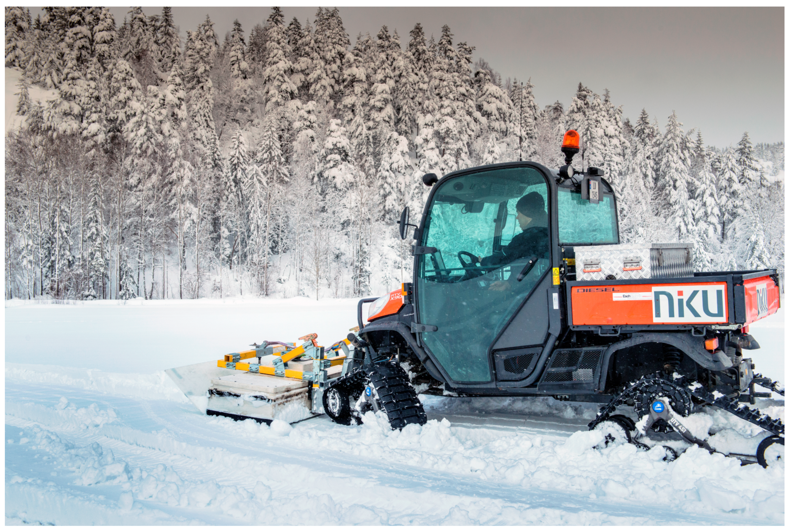
Therefore, the goals of the study presented here were to find practical solutions for the efficient use of motorised multi-channel GPR systems on snow, as well as to evaluate to which extent the thickness of the snow cover affects the quality of the collected prospection data under real conditions [
9]. To achieve these goals, NIKU’s motorised GPR array system was mechanically modified to enable measurements on snow. Four previously surveyed sites with known archaeological remains in the ground were re-surveyed under different snow conditions, making it possible to compare and evaluate the GPR results from sites with and without snow cover.
3. Survey Sites
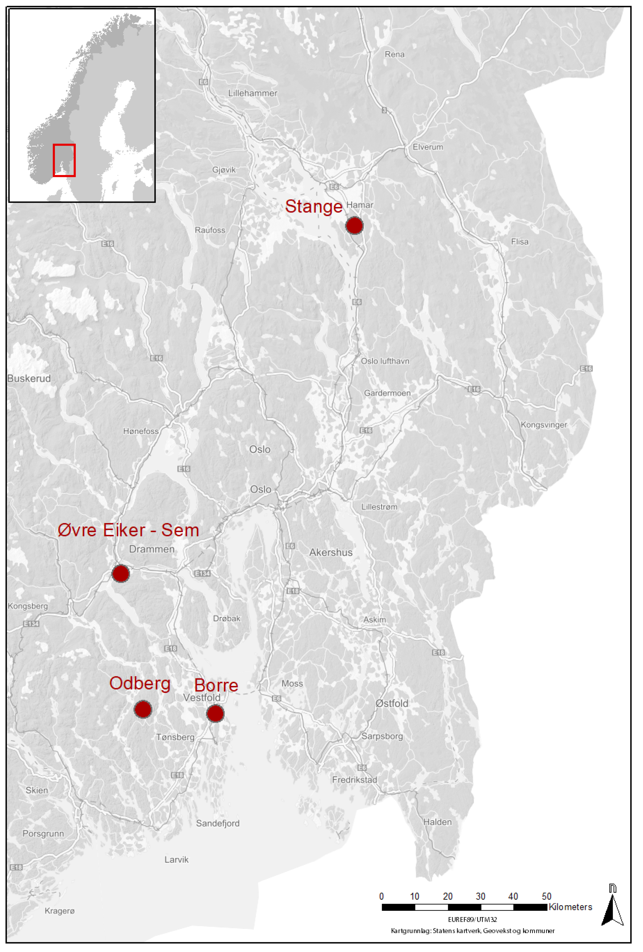
In total, four sites located in southern Norway (Borre, Odberg in Lågendalen, Stange, Sem–Øvre Eiker) have been included in this study (
Figure 3). The sites Borre, Stange and Sem–Øvre Eiker were earlier investigated with a MIRA system under snow-less conditions and showed clear archaeological remains in the data. In case of the site Odberg in Lågendalen, the reference data set without snow cover had been collected with a manual single-channel GPR survey with 25 cm cross-line spacing in 2007 [
24]. In 2018 all four sites were remeasured with the above described MIRA system with snow cover under different measurement conditions. At each site the local temperature was measured and a small pit was dug into the snow in order to determine the snow thickness, as well as to observe if the ground surface under the snow cover was frozen (
Figure 4).
Table 1 shows an overview of the measurement conditions at the sites and a more detailed description about the sites and actual surveys follows below.
3.1. Borre
Borre is a famous Scandinavian Iron Age/Viking Age archaeological site located in Vestfold County on the western coast of Oslo Fjord. Some 50 burials and nine monumental burial mounds dating from 600–900 CE are known in the Borre Park area. In 2007, archaeological prospection surveys using manual magnetometry and GPR measurements conducted by the archaeological prospection group of the Swedish National Heritage Board revealed traces of buried remains of two large Iron Age hall buildings [
3]. In 2013, initial motorised GPR test measurements on snow have been conducted with a snow scooter towing a six-channel 500 MHz Sensors & Software SPIDAR system with 25 cm cross-line spacing, resulting in the discovery of an additional prehistoric hall building [
4]. At Borre, more then 20 hectares has been subsequently investigated with repeated detailed as well as extensive high-resolution GPR surveys over the past years and especially during the Borre Monitoring Project [
25].
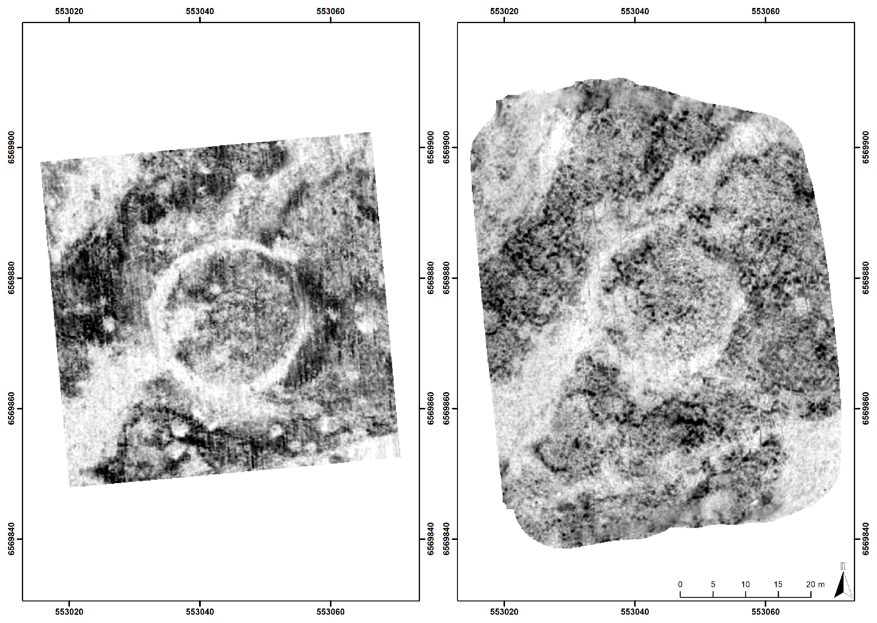
In July 2016, the area comprising the first two discovered hall buildings was surveyed with NIKU’s MIRA system under dry conditions without snow cover, resulting in high quality data clearly showing in the GPR depth-slices the anomalies associated with the buried archaeological remains, consisting of post-holes, small wall trenches and layers. These data form the reference for the comparison with data acquired during later measurements on snow. On 9 February 2018, when the ground was frozen and covered with approximately 5 cm of dry, compacted snow, at an air temperature of −3 C, the area was investigated with the winter-adapted MIRA system. The newly surveyed area covers 0.6 ha.
3.2. Odberg in Lågendalen
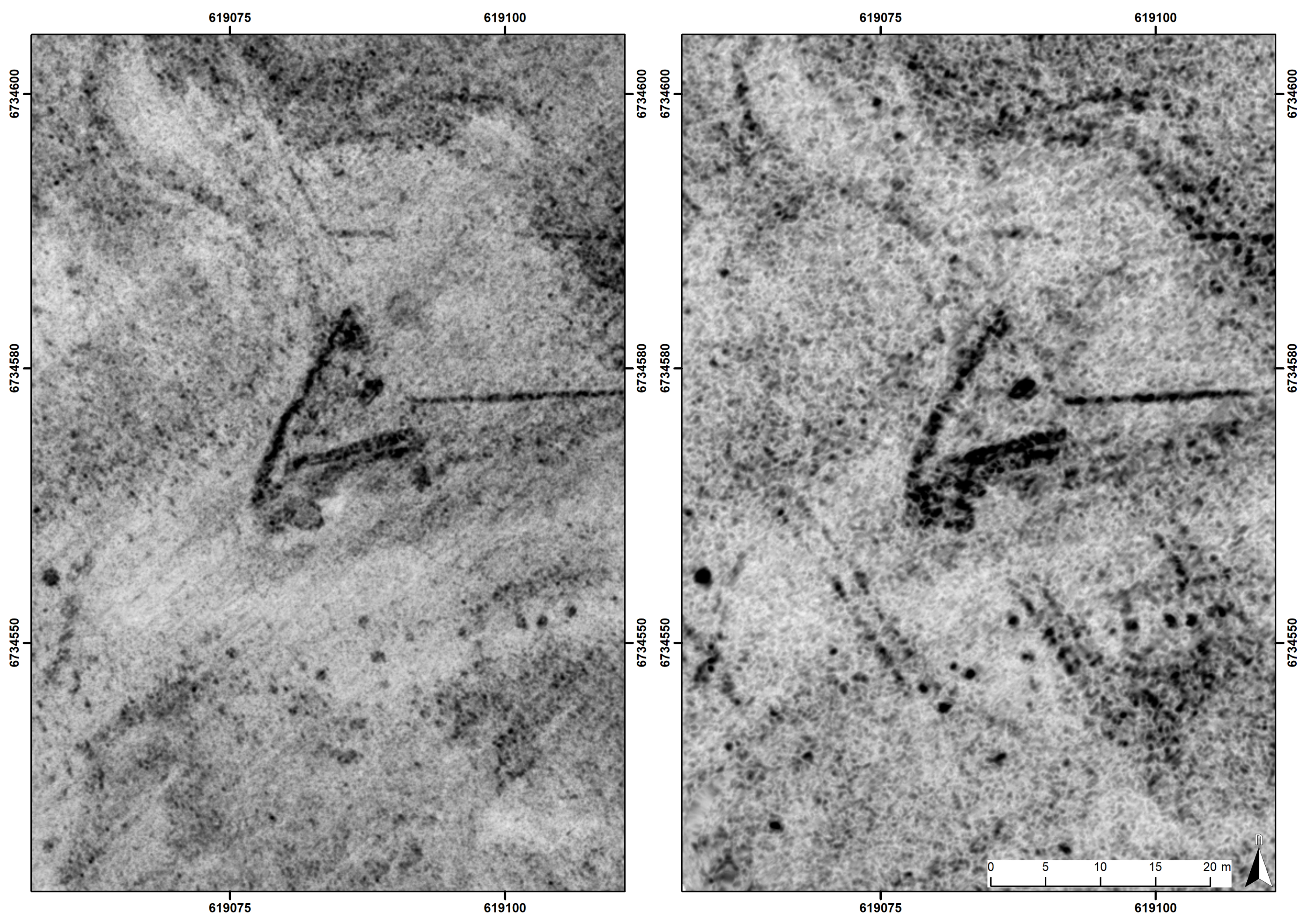
In May 2007, the archaeological prospection unit of the Swedish National Heritage Board conducted an archaeological prospection pilot study at Odberg in Lågendalen in collaboration with archaeologists of Vestfold County Administration using a Sensors & Software 500 MHz single-channel GPR system with 25 cm cross-line spacing, covering an area of 50 × 50 m (0.25 ha) [
24]. The results showed the buried remains of a large over-ploughed burial mound with a central grave including stone packing, surrounded by a circular ditch with ca. 25 m diameter, as well as some 50 additional burial pits. On 12 February 2018, the same area was investigated with the winter-adapted MIRA system with 10.5 cm cross-line channel spacing. The newly investigated area covers 0.35 ha. During the winter survey the ground was frozen, covered with ca. 90–100 cm of snow (
Figure 4), and the air temperature was −1
C. As the field was not accessible after the winter measurements in 2018, no measurements with the MIRA system without snow cover have yet been available. Therefore, the data comparison is based on the high-resolution results obtained by the manual GPR survey conducted in 2007.
3.3. Stange
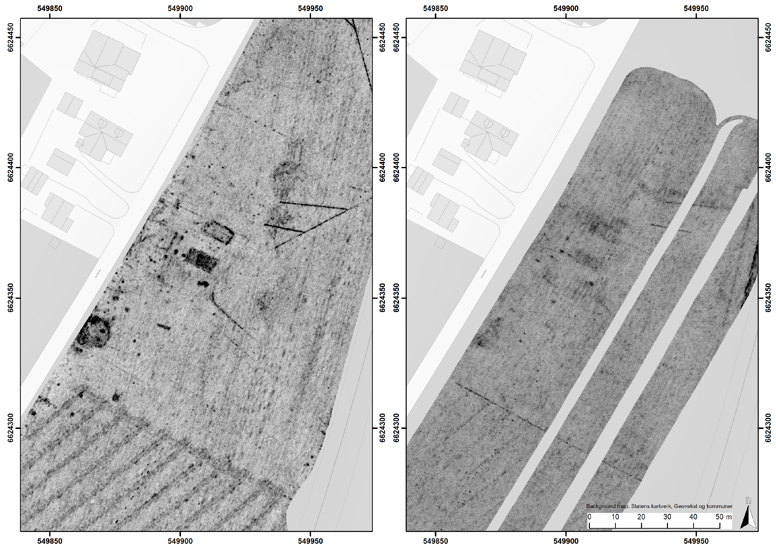
In 2017, NIKU conducted extensive GPR surveys in the area Stange/Åkersvika (Hedmark County) as part of archaeological registrations in connection with a railroad construction project [
26]. In addition to modern infrastructure such as field drainage systems, the GPR survey resulted in the detection of a large number of assumed cooking pits of archaeological interest. Later, trenching conducted by archaeologists of Hedmark County confirmed the interpretation of the detected GPR anomalies as having been caused by the buried remains of prehistoric pits. On 2 March 2018, when the ground was frozen and covered with ca. 40–50 cm of snow at air temperatures of −11
C to −8
C, the same area was investigated with the winter-adapted MIRA system. On that occasion, the area investigated by motorised GPR measurements covered 2.2 ha.
3.4. Sem–Øvre Eiker
Furthermore, in 2017 NIKU conducted a motorised GPR survey at Sem–Øvre Eiker municipality in Buskerud County. A large number of anomalies of archaeological interest were detected, both supposedly dating to prehistoric as well as historic periods. In particular the remains of a likely manor house were clearly visible in the GPR data [
27]. On 21 March 2018, the area comprising the remains of the assumed manor house was revisited with the MIRA system adapted for winter surveys. The newly investigated area of 2.8 ha was covered with a snow layer of ca. 40 cm thickness, the ground surface was partly frozen and the air temperature was between +1
C and +5
C.
4. Observations
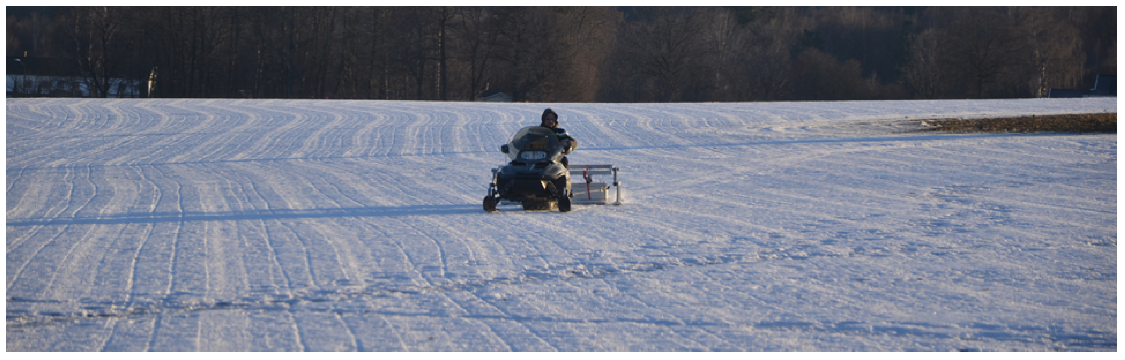
The analysis of the data gathered within this project showed that the mechanical adaptation of the motorised MIRA system for snow measurements worked satisfactorily. The large glide plate enabled the GPR antenna to slide easily on top of the snow surface without significantly impacting the snow layer underneath. The fact that the GPR antennae box was mounted in front of the Kubota permitted the measurement of the undisturbed snow as the vehicle tracks were formed behind the GPR array. The inevitable drawback of this approach is that areas with thick snow cover can only be surveyed one at a time, as the crawlers and the weight of the system will compact the pristine snow layer, leading to differing surface texture and composition, resulting in striping in the data sets in case of re-surveying of already covered snow areas. The snow crawler belts mounted on the Kubota RTV enabled very stable driving conditions on areas covered with up to one metre of snow. In flat and open areas, it was possible to survey with this system approximately 0.7 hectares/hour. Results from a different, large-scale GPR survey project, in which this system has been used, demonstrated that it was possible to survey 22 ha of snow-covered farmland in five measurement days, which is similarly efficient to surveys on fields without snow cover [
28].
Data processing with the software APRadar worked well for all the data that were gathered under snow and snow-less conditions and the used processing steps were the same. Naturally, due to different GPR velocities and the snow cover, some processing parameters for the GPR velocity model, band-pass frequency filtering or spike removal had to be adapted in order to give the best results for each individual measurement. However, as such adjustments are common steps for each individual GPR data processing, there is no observable difference in the processing workflow between snow and snow-less conditions.
The data comparison at Borre showed that a thin, compact and dry snow layer over frozen ground can result in very good visibility of the anomalies caused by the archaeological target structures in the corresponding GPR data. As it can be seen in
Figure 5, the contrast between the archaeological features of interest and the surrounding soil matrix appears greater for the data acquired on snow and frozen ground, resulting in clearer expressed anomalies in the GPR depth-slices compared to those measured on bare ground. It is assumed that the frozen soil humidity results in a reduced absorption of the electromagnetic GPR pulses in the topsoil, and thus increased imaging contrast between the archaeological features and the surrounding soil.
The results from Odberg show that even though the area was covered with a thick layer of one metre of snow, the corresponding GPR depth-slices reveal a number of relevant archaeological remains detected during the snow-free investigation (
Figure 6). Nevertheless, the archaeological features from the winter measurements at this site appear less distinct and considerably more blurred in the GPR depth-slice images than those of the earlier survey. This can be explained by the larger distance of the GPR antennae to the ground and the resulting larger footprint and reduced lateral resolution of the GPR signal [
1], p. 62.
The results from Stange show that all the earlier detected archaeological remains could be identified, even though the field was ploughed and covered with a snow layer of ca. 30–50 cm thickness (
Figure 7). However, as at Odberg, the archaeological features in the winter data appear less clearly expressed than those mapped under snow-free conditions, due to the larger distance of the GPR antennae to the ground. In addition, the in winter time collected data show some parallel, linear features compared to the earlier measurements, which are caused by the archaeological excavation trenches dug after the initial GPR survey in 2017.
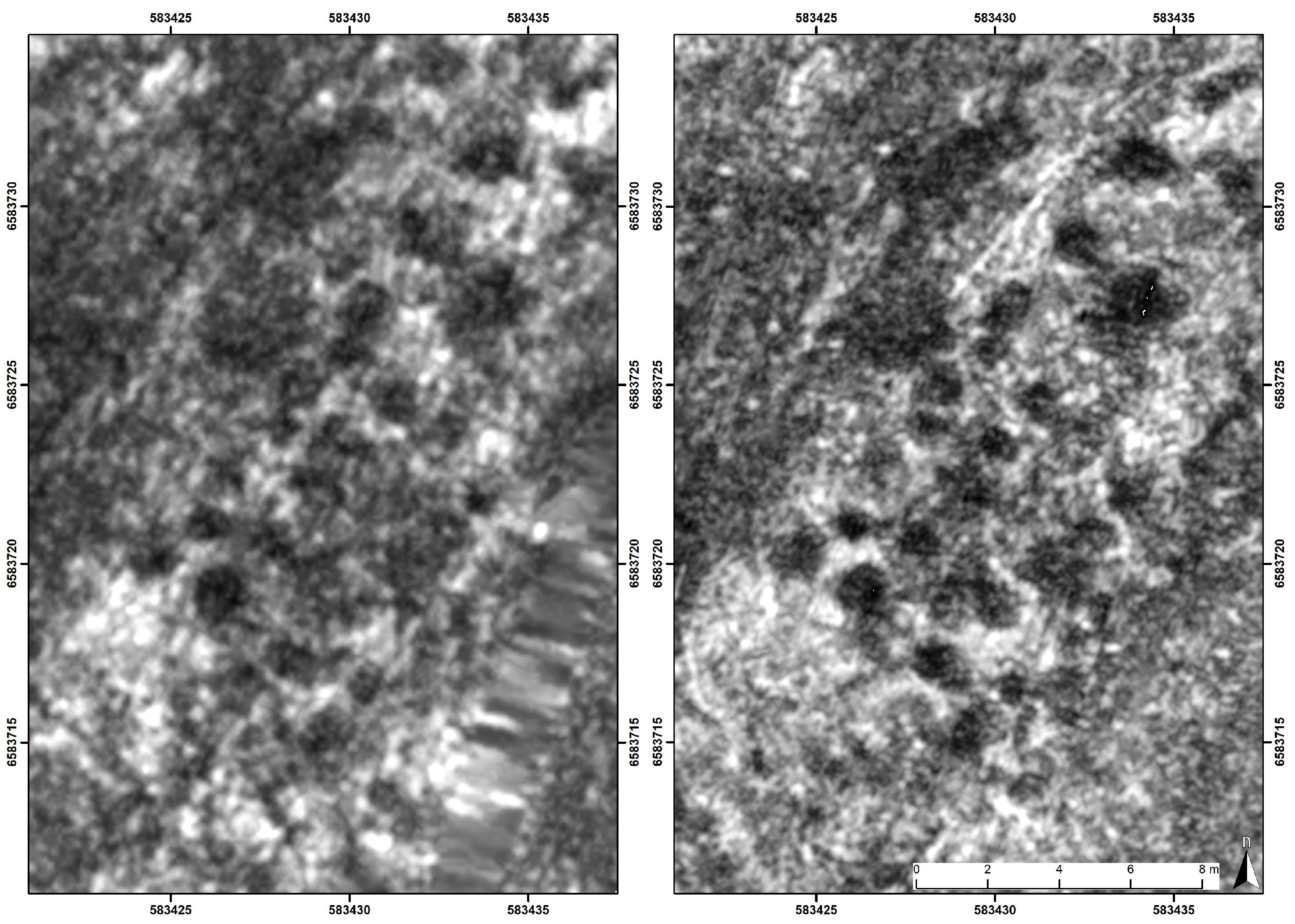
With the results obtained at the first three test areas in mind, it was expected that the GPR data recorded at Sem–Øvre Eiker would show similar positive results. However, although the field was covered with a snow layer of merely ca. 40 cm thickness and archaeological structures were clearly visible in the GPR data acquired under snow-free conditions, the results from the measurements conducted on snow hardly showed any structures at all in the GPR depth-slice images (
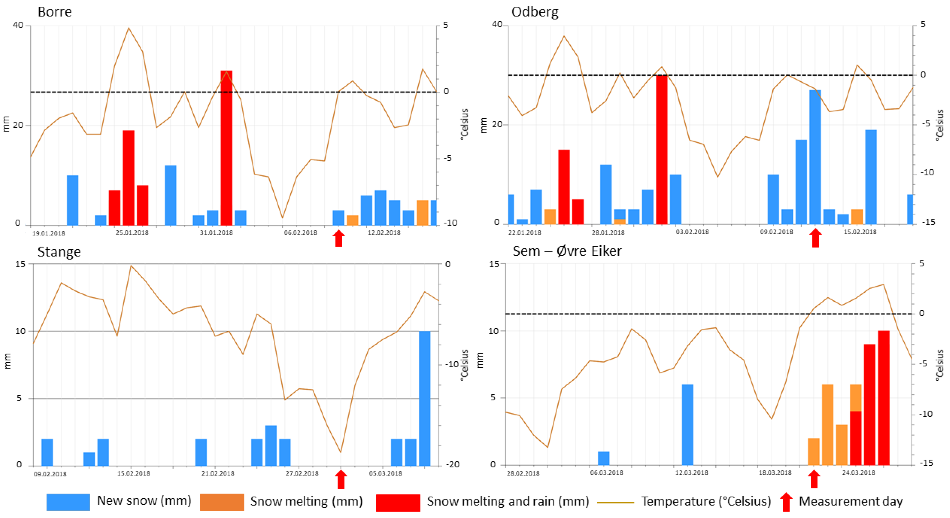
Figure 8). As the snow thickness was the primary focus of this first investigation, the water content, snow density and electrical conductivity of the snow was not measured in-situ. For the evaluation of the snow conditions (amount of new snow, snow melting, liquid water content), measurements and models from the Norwegian Meteorological Institute (MET) and the Norwegian Water Resources and Energy Directorate (NVE) were used (
www.senorge.no). Based on these data, the most likely explanation for the poor results obtained at Sem is an increased water content within or below the snow layer.
Figure 9 shows that unlike in the case of the other investigations discussed here, at Sem the temperature had changed to above freezing on the day prior to the begin of the measurements. This temperature increase is likely to have affected the snow conditions, with an increased liquid water content in the snow layer, or water accumulation at the snow-soil interface to such an extent that most of the GPR pulse energy was reflected or absorbed and did not penetrate into the subsurface.
5. Discussion
The results show that archaeological prospection with a motorised multi-channel GPR system can be successful even in areas covered with a substantial layer of snow. However, the GPR measurements on frozen ground with a thin snow cover of only 5–10 cm thickness resulted in the data images with highest signal-to-noise ratio regarding the archaeological target structures, better even than measurements conducted on bare ground at temperatures above freezing.
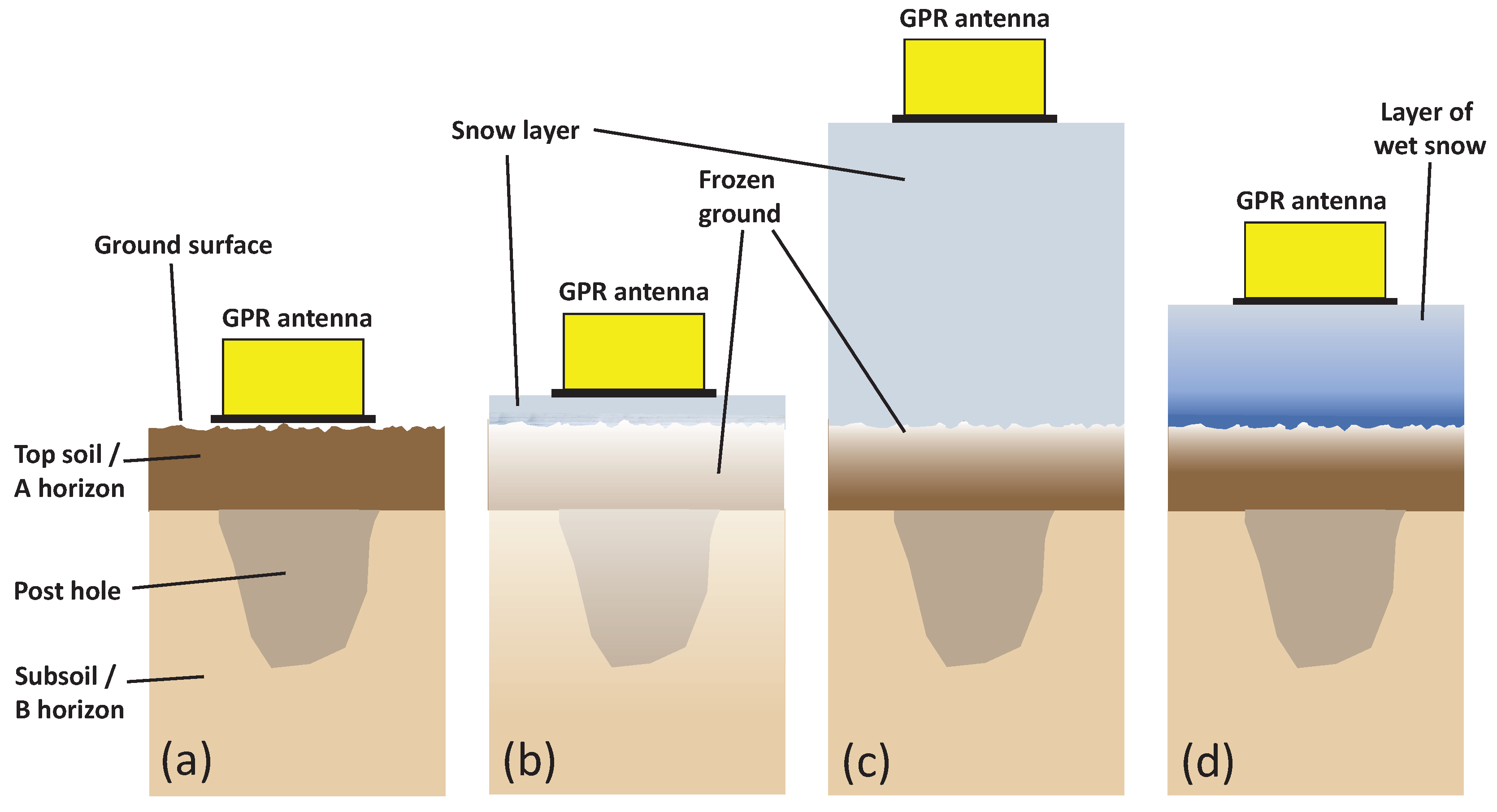
Figure 10 illustrates the four different situations encountered in this study:
- (a)
Normal survey on ground without snow cover at temperatures above freezing.
- (b)
Survey on frozen ground covered with a thin layer of dry snow, as the situation encountered at Borre in winter time.
- (c)
Survey on a thick layer of dry snow. Due to the insulating character of the snow layer the ground possibly has not been as deeply frozen as in case (b). This is assumed to have been the situation encountered at Odberg. The situation encountered at Stange is assumed to have been between situations (b) and (c).
- (d)
Survey on medium thick layer of wet snow above frozen ground. The snow contains wet water due to thawing and rainfall, causing a liquid water accumulation at the snow-ground surface. This is assumed to have been the situation encountered at Sem.
The differences in obtained data quality in regard to the imaging of buried archaeological remains is understood to have been mainly caused by the variable GPR pulse absorption rates due to the different properties of the snow cover and the underlying topsoil.
Table 2 lists GPR pulse propagation parameters relevant for media encountered in this study, derived for a 400 MHz pulse (
http://gpr-parameters.ch). The GPR pulse attenuation
is computed as a function of the relative dielectric constant
and the electrical conductivity
[
29]
We see that a layer of dry snow hardly attenuates the GPR pulse at all. Its thickness may however have a detrimental effect on the image resolution due to geometrical spreading of the GPR pulse, as discussed below. In general, the air/ground interface can have a dramatic effect on all GPR measurements in which the antenna is not placed closely on the ground surface. Too great a distance from the ground will cause the reflection of a large part of the transmitted electromagnetic energy of the GPR pulse, preventing it from reaching further below for subsurface imaging. Critical distances of the GPR antenna from the ground surface are those greater than one quarter to a half of the wavelength of the transmitted pulse.
When the air temperature is above zero and the top soil is not frozen, the amount of liquid water in the soil has a great effect on GPR pulse propagation and attenuation. “
Water is the single biggest factor which determines the bulk electrical properties of materials in most Earth settings” stated Davis and Annan [
29] in 1989. The topsoil, which in agriculturally used fields corresponds to the plough layer, is rich in organic material and pore space between the solid particles, comprising the soil water [
30]. In media where liquid water is present, dramatic changes of the GPR velocity can occur, complicating the imaging of buried structures, as described by Urban et al. [
19]. The electrical properties of water change dramatically when freezing [
31], resulting in frozen soil to behave very differently than soil that is not frozen. According to the values listed in
Table 2, frozen soil has a signal attenuation of 0.138 dB/m, which is considerably less than the values for loamy or clayey soils. Only dry sand has a lower attenuation among the soils. Snow has a very low attenuation factor of 0.003 dB/m. While no attenuation value is given for wet snow, in comparison it can be assumed that it is similar to the much increased attenuation observed in wet sand.
Our results suggest that in case of a frozen top soil, the downward travelling GPR pulse is less attenuated than in the case where liquid soil humidity is present. In frozen top soil a larger amount of electromagnetic energy is able to reach the undisturbed structures of archaeological interest below the plough layer, and to be reflected from there back to the surface, resulting in clearer expressed anomalies. When the soil is frozen (
≈ 6) and the ground surface is covered with a layer of snow (
≈ 9), no significant reflection of the GPR pulse is generated at the snow-soil interface due to the small difference in relative permittivity
between the two media. However, when liquid water is present in the layer of snow, or has accumulated at the snow-soil interface, the GPR pulses suffer from increased absorption. Furthermore, the reflection of a substantial amount of GPR pulse energy at the snow-soil interface prevents this energy from imaging structures of interest further below. The authors of Gusmeroli and Grosse [
32] observed that, in synthetic GPR 2D data computed for snow packs on top of ice, the reflections from the base of the snow-pack are lowest for dry snow-ice interfaces, and that they are “dramatically” increased when a layer of slush consisting of water, ice and air is introduced between the snow and underlying ice.
In a comparable experiment, Gary Koh of the US Army Corps of Engineers–Cold Regions Research & Engineering Laboratory–studied in 1997 the effect of frozen ground on the GPR detection of land mines by surveying buried anti-tank mines on 9 and 15 December at soil temperatures of 0.2
C and −1.5
C respectively. He noted that “
under appropriate conditions, the winter environment can enhance the performance of a radar system. The ability of the radar signal to penetrate frozen ground can dramatically improve the performance of a radar mine detection system in a winter environment” [
33]. He concluded that “
the effect of frozen soil is to enhance radar penetration, which greatly improves the probability of detection”. This is very much consistent with our observations.
Of further relevance for the qualitative analysis presented here is the spatial imaging resolution that is affected by the increasing distance between the GPR antenna and the target structure in case of snow coverage. The lateral resolution of GPR measurements depends on the wavelength of the GPR pulse and the distance of the reflecting structure according to the following relationship:
where
L equals the distance between the antenna and the reflecting structure in [m] and
is the wavelength of the GPR pulse in [m] [
34]. In the case of a layer of snow, in which a 400 MHz GPR pulse would have a wavelength of 25 cm, the lateral resolution at 5 cm distance would be 10 cm, while at 50 cm distance, or snow thickness, it would be 26 cm, and at 100 cm distance it would be 36 cm. Considering that the wavelength would be larger in frozen soil, the lateral resolution would increase even more when the GPR pulse travels though a layer of frozen topsoil. Thus, the best imaging conditions would be achieved with minimum snow cover. A thin layer of snow evens out surface roughness and facilitates navigation due to the visible tracks generated by the GPR system, and could be seen favourable over no snow cover at all. Depending on the snow thickness, increasing footprint and the risk of water inclusions, or melt water accumulation at the snow-soil interface, the meaningfulness of large-scale GPR surveys on thick layers of snow have to be evaluated case by case. Snow cover insulates the ground and retains heat loss from the earth, reducing freezing depth: where there is a thick snow cover the ground may freeze only a few centimetres, while on barren ground the ground may freeze deeper.
6. Conclusions
The presented project had the goals to develop a stable system for snow measurements and to study the influence of snow thickness on the GPR data quality for archaeological investigations under real conditions. The mechanical adaptions and the good visibility of the tracks enabled investigations nearly as fast on snow as on dry conditions. The comparison showed good results for up to half a metre of snow cover, as long as the temperatures were well below zero degrees Celsius and the ground was frozen. Data quality was reduced with thicker snow cover, rendering such situations suboptimal for large-scale high-resolution archaeological prospection GPR surveys. A thin layer of a few centimetres of snow over frozen ground improved the data quality significantly. In one of the four investigated cases the data showed nearly no archaeological anomalies on snow covered areas. It is assumed that this was due to the warmer temperature (plus degrees), which increased the liquid water content in the snow, rendering absorption too high for meaningful GPR measurements for archaeological purposes.
Generally, the results showed that snow covered areas can be successfully investigated with motorised multi-channel GPR for archaeological purposes, if the snow cover is not too thick. This finding allows for a longer fieldwork period, and provides access to areas that otherwise may be difficult to investigate, such as uneven terrain or bog areas. In any case, the temperature and snow quality must be taken into consideration before commencing with the GPR survey. For this reason, further research is necessary to gain a better understanding of the influence of the snow and weather conditions in combination with the conditions of the underlying sub soil. Thus, a long-term monitoring project with buried sensors in the ground as well as in situ measurements of the snow conditions and repeating GPR measurements might be a favourable approach in order to investigate the influence of weather, frozen soil and snow for the visibility of buried archaeological structures.

 ,
, 


