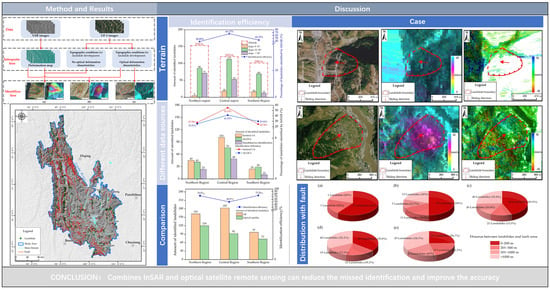
Integration of Sentinel-1A, ALOS-2 and GF-1 Datasets for Identifying Landslides in the Three Parallel Rivers Region, China
Abstract
:1. Introduction
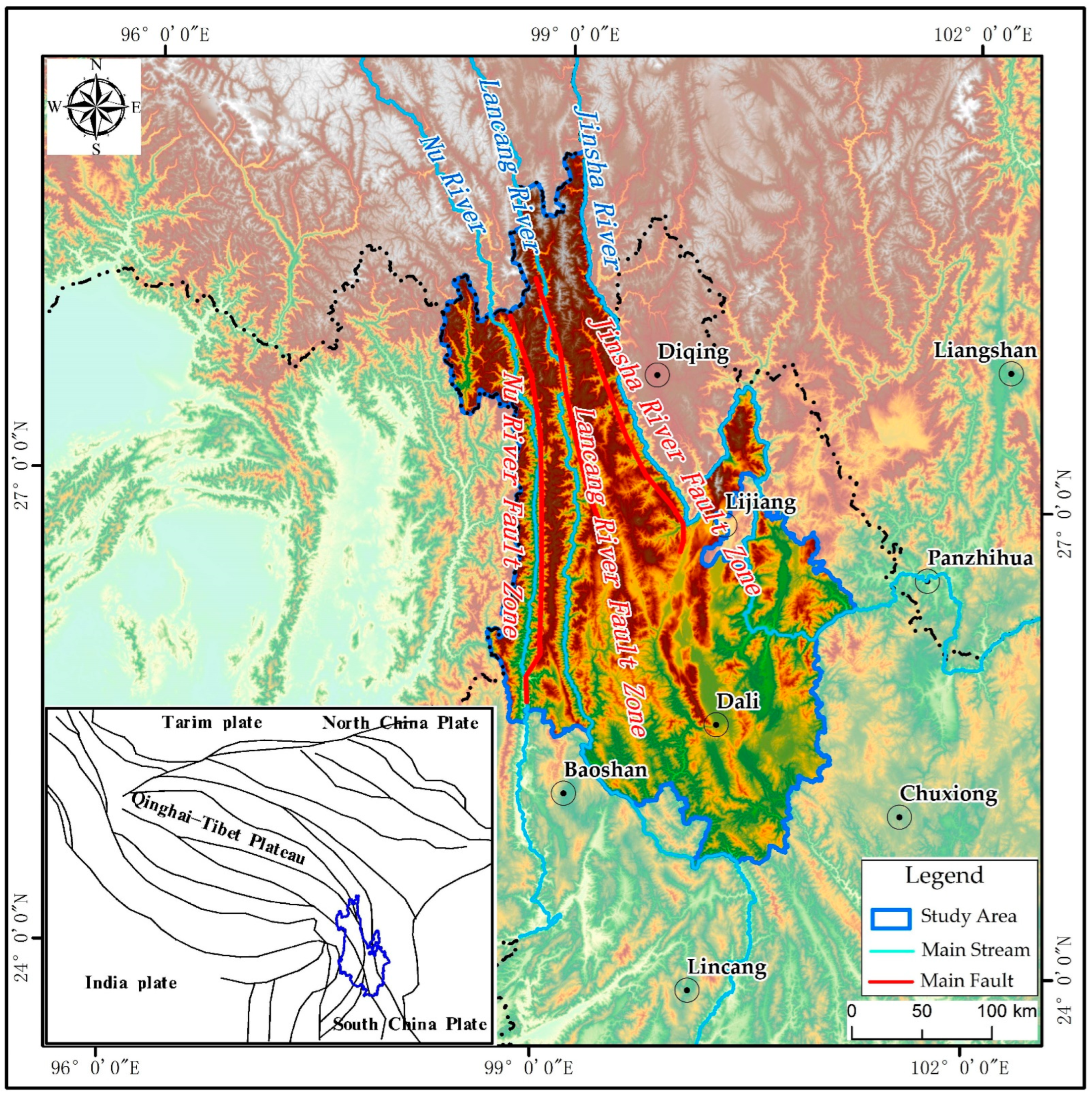
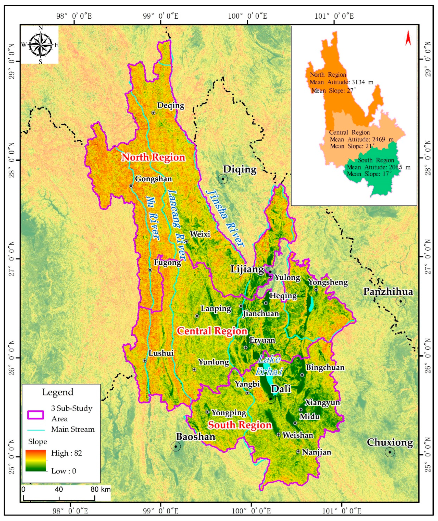
2. Study Area
3. Materials and Methods
3.1. Data Source
3.1.1. SAR Satellite Dataset
3.1.2. Optical Satellite Data
3.2. Data Processing Method
3.2.1. InSAR Data Processing Method
3.2.2. Identification Method of Active Landslides
4. Results
5. Discussion
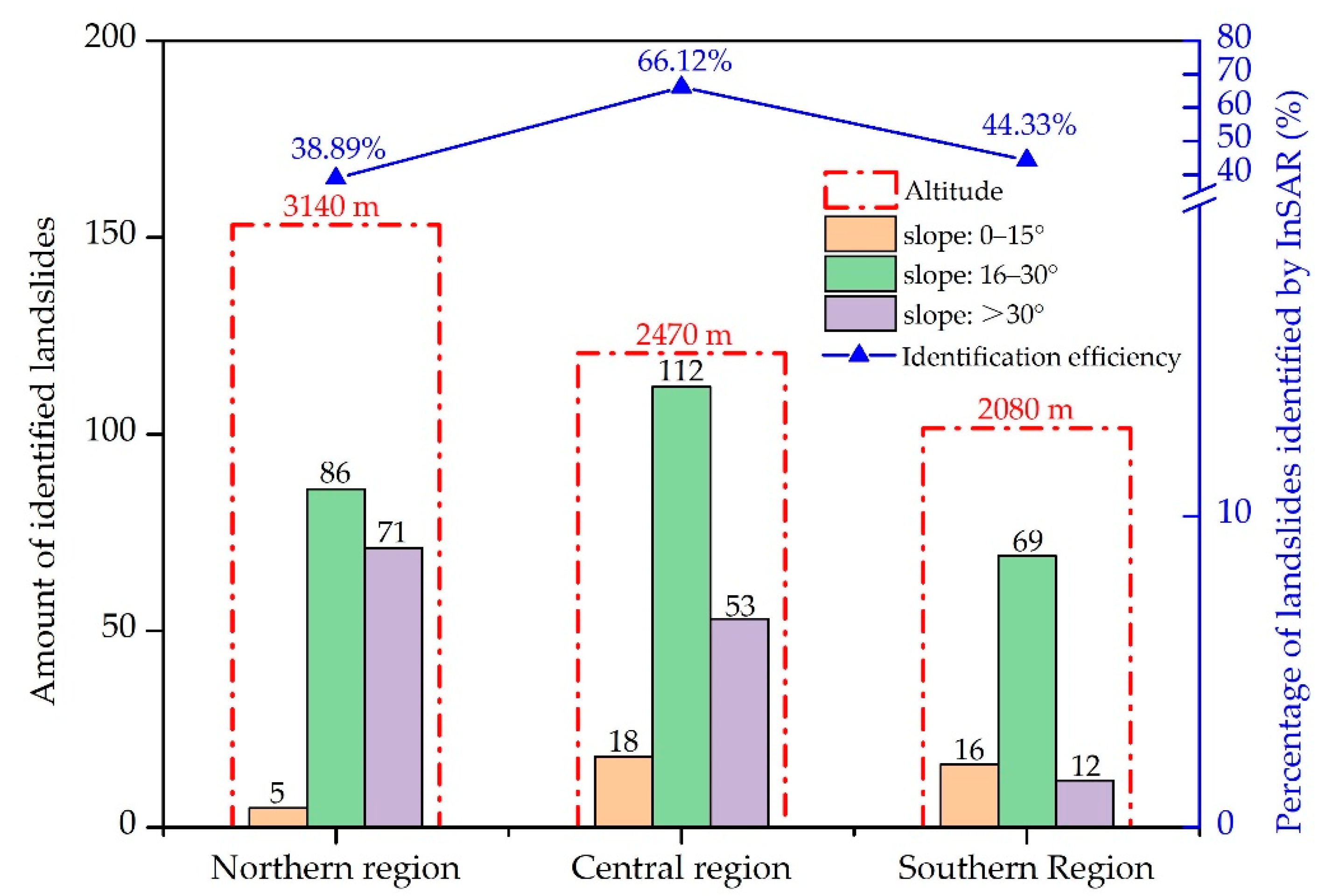
5.1. Landslide Terrain and InSAR Identification Effect
5.2. Comparison of Landslide Identification Effect between ALOS-2 Data and Sentinel-1A Data by InSAR
5.3. Comparison of InSAR and Optical Satellite Remote Sensing
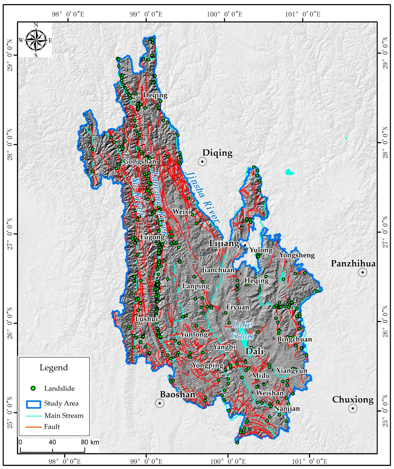
5.4. Distribution of Landslides and Fault Zones
6. Conclusions
Author Contributions
Funding
Institutional Review Board Statement
Informed Consent Statement
Data Availability Statement
Acknowledgments
Conflicts of Interest
References
- Ao, S.; Li, X.; Tian, Z.; Hu, J.; Cai, Q. Harmonizing and Searching Macroinvertebrate Trait Information in Alpine Streams: Method and Application–A Case Study in the Three Parallel Rivers Region, China. Front. Ecol. Evol. 2022, 10, 945824. [Google Scholar] [CrossRef]
- Myers, N.; Mittermeler, R.A.; Mittermeler, C.G.; Da Fonseca, G.A.B.; Kent, J. Biodiversity hotspots for conservation priorities. Nature 2000, 403, 853–858. [Google Scholar] [CrossRef] [PubMed]
- Wang, S.; Wu, S.; He, D.; Dai, E.; Zhou, C.; Wei, Q. Comparability in geomorphic evolution of the three rivers in the northern Longitudinal Range-Gorge Region: Evidence of statistic relationships between geomorphic parameters and analyses of cause of formation. Chin. Sci. Bull. 2006, 51, 39–49. [Google Scholar]
- Xing, Y.; Ree, R.H. Uplift-driven diversification in the Hengduan Mountains, a temperate biodiversity hotspot. Proc. Natl. Acad. Sci. USA 2017, 114, 3444–3451. [Google Scholar] [CrossRef] [PubMed] [Green Version]
- Wang, F.; Wang, M.; Wang, Y.; Shen, Z. Earthquake potential of the Sichuan-Yunnan region, western China. J. Asian Earth Sci. 2015, 107, 232–243. [Google Scholar] [CrossRef]
- Tu, G.; Deng, H. Unloading depth of rock masses and its relations with river downcutting in deep valleys in Southwest China. Eng. Geol. 2021, 288, 106161. [Google Scholar] [CrossRef]
- Ding, M.; Wei, F. Distribution Characteristics of Debris Flows and Landslides in Three Rivers Parallel Area. Disaster Adv. 2011, 4, 7–14. [Google Scholar]
- Yao, X.; Deng, J.; Liu, X.; Zhou, Z.; Yao, J.; Ren, K.; Li, L. Primary Recognition of Active Landslides and Development Rule Analysis for Pan Three-river-parallel Territory of Tibet Plateau. Adv. Eng. Sci. 2020, 52, 16–37. [Google Scholar]
- Harp, E.L.; Keefer, D.K.; Sato, H.P.; Yagi, H. Landslide inventories: The essential part of seismic landslide hazard analyses. Eng. Geol. 2011, 122, 9–21. [Google Scholar] [CrossRef]
- Du, J.; Glade, T.; Woldai, T.; Chai, B.; Zeng, B. Landslide susceptibility assessment based on an incomplete landslide inventory in the Jilong Valley, Tibet, Chinese Himalayas. Eng. Geol. 2020, 270, 105572. [Google Scholar] [CrossRef]
- Galli, M.; Ardizzone, F.; Cardinali, M.; Guzzetti, F.; Reichenbach, P. Comparing landslide inventory maps. Geomorphology 2008, 94, 268–289. [Google Scholar] [CrossRef]
- Pellicani, R.; Spilotro, G. Evaluating the quality of landslide inventory maps: Comparison between archive and surveyed inventories for the Daunia region (Apulia, Southern Italy). Bull. Eng. Geol. Environ. 2015, 74, 357–367. [Google Scholar] [CrossRef]
- Nichol, J.; Wong, M.S. Detection and interpretation of landslides using satellite images. Land Degrand. Dev. 2005, 16, 243–255. [Google Scholar] [CrossRef]
- Fiorucci, F.; Cardinali, M.; Carla, R.; Rossi, M.; Mondini, A.C.; Santurri, L.; Ardizzone, F.; Guzzetti, F. Seasonal landslide mapping and estimation of landslide mobilization rates using aerial and satellite images. Geomorphology 2011, 129, 59–70. [Google Scholar] [CrossRef]
- Cheng, Z.; Gong, W.; Tang, H.; Juang, C.; Deng, Q.; Chen, J.; Ye, X. UAV photogrammetry-based remote sensing and preliminary assessment of the behavior of a landslide in Guizhou, China. Eng. Geol. 2021, 289, 106172. [Google Scholar] [CrossRef]
- Jaboyedoff, M.; Oppikofer, T.; Abellán, A.; Derron, M.H.; Loye, A.; Metzher, R.; Pedrazzini, A. Use of LiDAR in landslide investigations: A review. Nat. Hazards 2012, 61, 5–28. [Google Scholar] [CrossRef] [Green Version]
- Görüm, T. Landslide recognition and mapping in a mixed forest environment from airborne LiDAR data. Eng. Geol. 2019, 258, 105155. [Google Scholar] [CrossRef]
- Xu, Q.; Guo, C.; Dong, X.; Li, W.; Lu, H.; Fu, H.; Liu, X. Mapping and Characterizing Displacements of Landslides with InSAR and Airborne LiDAR Technologies: A Case Study of Danba County, Southwest China. Remote Sens. 2021, 13, 4234. [Google Scholar] [CrossRef]
- Wasowski, J.; Bovenga, F. Investigating landslides and unstable slopes with satellite Multi Temporal Interferometry: Current issues and future perspectives. Eng. Geol. 2014, 174, 103–138. [Google Scholar] [CrossRef]
- Scaioni, M.; Longoni, L.; Melillo, V.; Papini, M. Remote Sensing for landslide investigations: An overview of recent achievements and perspectives. Remote Sens. 2014, 6, 9600–9652. [Google Scholar] [CrossRef] [Green Version]
- Zhang, L.; Dai, K.; Deng, J.; Ge, D.; Liang, R.; Li, W.; Xu, Q. Identifying Potential Landslides by Stacking-InSAR in Southwestern China and Its Performance Comparison with SBAS-InSAR. Remote Sens. 2021, 13, 3662. [Google Scholar] [CrossRef]
- Liang, J.; Dong, J.; Zhang, S.; Zhao, C.; Liu, B.; Yang, L.; Yan, S.; Ma, X. Discussion on InSAR Identification Effectivity of Potential Landslides and Factors That Influence the Effectivity. Remote Sens. 2022, 14, 1952. [Google Scholar] [CrossRef]
- Zhao, C.; Kang, Y.; Zhang, Q.; Lu, Z.; Li, B. Landslide Identification and monitoring along the Jinsha River Catchment (Wudongde Reservoir Area), China, using the InSAR Method. Remote Sens. 2018, 10, 993. [Google Scholar] [CrossRef]
- Liu, X.; Zhao, C.; Zhang, Q.; Lu, Z.; Li, Z.; Yang, C.; Zhu, W.; Liu-Zeng, J.; Chen, L.; Liu, C. Integration of Sentinel-1 and ALOS/PALSAR-2 SAR datasets for mapping active landslides along the Jinsha River corridor, China. Eng. Geol. 2021, 284, 106033. [Google Scholar] [CrossRef]
- Wang, Z.; Xu, J.; Shi, X.; Wang, J.; Zhang, W.; Zhang, B. Landslide Inventory in the Downstream of the Niulanjiang River with ALOS PALSAR and Sentinel-1 Datasets. Remote Sens. 2022, 14, 2873. [Google Scholar] [CrossRef]
- Cao, C.; Zhu, K.; Song, T.; Bai, J.; Zhang, W.; Chen, J.; Song, S. Comparative Study on Potential Landslide Identification with ALOS-2 and Sentinel-1A Data in Heavy Forest Reach, Upstream of the Jinsha River. Remote Sens. 2022, 14, 1962. [Google Scholar] [CrossRef]
- Dong, J.; Zhang, L.; Li, M.; Yu, Y.; Liao, M.; Gong, J.; Luo, H. Measuring precursory movements of the recent Xinmo landslide in Mao County, China with Sentinel-1 and ALOS-2 PALSAR-2 datasets. Landslides 2018, 15, 135–144. [Google Scholar] [CrossRef]
- Farr, T.; Rosen, P.; Caro, E.; Crippen, R.; Duren, R.; Hensley, S.; Kobrick, M.; Paller, M.; Rodriguez, E.; Roth, L.; et al. The Shuttle Radar Topography Mission. Rev. Geophys. 2007, 45, RG2004. [Google Scholar] [CrossRef] [Green Version]
- Zhao, C.; Lu, Z.; Zhang, Q.; de la Fuente, J. Large-area landslide detection and monitoring with ALOS/PALSAR imagery data over Northern California and Southern Oregon, USA. Remote Sens. Environ. 2012, 124, 348–359. [Google Scholar] [CrossRef]
- Liu, Y.; Qiu, H.; Yang, D.; Liu, Z.; Ma, S.; Pei, Y.; Zhang, J.; Tang, B. Deformation responses of landslides to seasonal rainfall based on InSAR and wavelet analysis. Landslides 2022, 19, 199–210. [Google Scholar] [CrossRef]
- Ao, M.; Zhang, L.; Dong, Y.; Su, L.; Shi, X.; Balz, T.; Liao, M. Characterizing the evolution life cycle of the Sunkoshi landslide in Nepal with multi-source SAR data. Sci. Rep. 2021, 10, 17988. [Google Scholar] [CrossRef]
- Di Maio, C.; Fornaro, G.; Gioia, D.; Reale, D.; Schiattarella, M.; Vassallo, R. In situ and satellite long-term monitoring of the Latronico landslide, Italy: Displacement evolution, damage to buildings, and effectiveness of remedial works. Eng. Geol. 2018, 245, 218–235. [Google Scholar] [CrossRef]
- Sandwell, D.; Price, E. Phase gradient approach to stacking interferograms. J. Volcanol. Geotherm. Res. 1998, 103, 30183–30204. [Google Scholar] [CrossRef]
- Wu, C.; Cui, P.; Li, Y.; Ayala, I.; Huang, C.; Yi, S. Seismogenic fault and topography control on the spatial patterns of landslides triggered by the 2017 Jiuzhaigou earthquake. J. Mt. Sci. 2018, 15, 793–807. [Google Scholar] [CrossRef]
- Dong, J.; Liao, M.; Xu, Q.; Zhang, L.; Tang, M.; Gong, J. Detection and displacement characterization of landslides using multi- temporal satellite SAR interferometry: A case study of Danba County in the Dadu River Basin. Eng. Geol. 2018, 240, 95–109. [Google Scholar] [CrossRef]
- Zhou, H.; Ye, F.; Fu, W.; Wei, Y.; Qin, Y.; Tang, W.; Fang, T. The activity, segmentation, and evolution characteristics of large-scale landslides along the Anninghe active fault zone, Southwest China. Bull. Eng. Geol. Environ. 2022, 81, 311. [Google Scholar] [CrossRef]
- Huang, R. Large-scale Landslides and Their Sliding Mechanisms in China Since the 20th Century. Chin. J. Rock Mech. Eng. 2007, 26, 433–454. [Google Scholar]







| Satellite | Orbital Direction | Band | Wavelength | Resolution | Temporal Coverage |
|---|---|---|---|---|---|
| Sentinel-1A | Ascending, Descending | C-band | 5.6 cm | 5 × 20 m | 2017.01–2020.01 |
| ALOS-2 | Ascending | L-band | 23.5 cm | 4 × 4 m | 2018.07–2019.07 |
Publisher’s Note: MDPI stays neutral with regard to jurisdictional claims in published maps and institutional affiliations. |
© 2022 by the authors. Licensee MDPI, Basel, Switzerland. This article is an open access article distributed under the terms and conditions of the Creative Commons Attribution (CC BY) license (https://creativecommons.org/licenses/by/4.0/).
Share and Cite
Zhao, C.; Liang, J.; Zhang, S.; Dong, J.; Yan, S.; Yang, L.; Liu, B.; Ma, X.; Li, W. Integration of Sentinel-1A, ALOS-2 and GF-1 Datasets for Identifying Landslides in the Three Parallel Rivers Region, China. Remote Sens. 2022, 14, 5031. https://doi.org/10.3390/rs14195031
Zhao C, Liang J, Zhang S, Dong J, Yan S, Yang L, Liu B, Ma X, Li W. Integration of Sentinel-1A, ALOS-2 and GF-1 Datasets for Identifying Landslides in the Three Parallel Rivers Region, China. Remote Sensing. 2022; 14(19):5031. https://doi.org/10.3390/rs14195031
Chicago/Turabian StyleZhao, Cong, Jingtao Liang, Su Zhang, Jihong Dong, Shengwu Yan, Lei Yang, Bin Liu, Xiaobo Ma, and Weile Li. 2022. "Integration of Sentinel-1A, ALOS-2 and GF-1 Datasets for Identifying Landslides in the Three Parallel Rivers Region, China" Remote Sensing 14, no. 19: 5031. https://doi.org/10.3390/rs14195031
APA StyleZhao, C., Liang, J., Zhang, S., Dong, J., Yan, S., Yang, L., Liu, B., Ma, X., & Li, W. (2022). Integration of Sentinel-1A, ALOS-2 and GF-1 Datasets for Identifying Landslides in the Three Parallel Rivers Region, China. Remote Sensing, 14(19), 5031. https://doi.org/10.3390/rs14195031


