
COSMIC-2 RO Profile Ending at PBL Top with Strong Vertical Gradient of Refractivity


Abstract
:1. Introduction
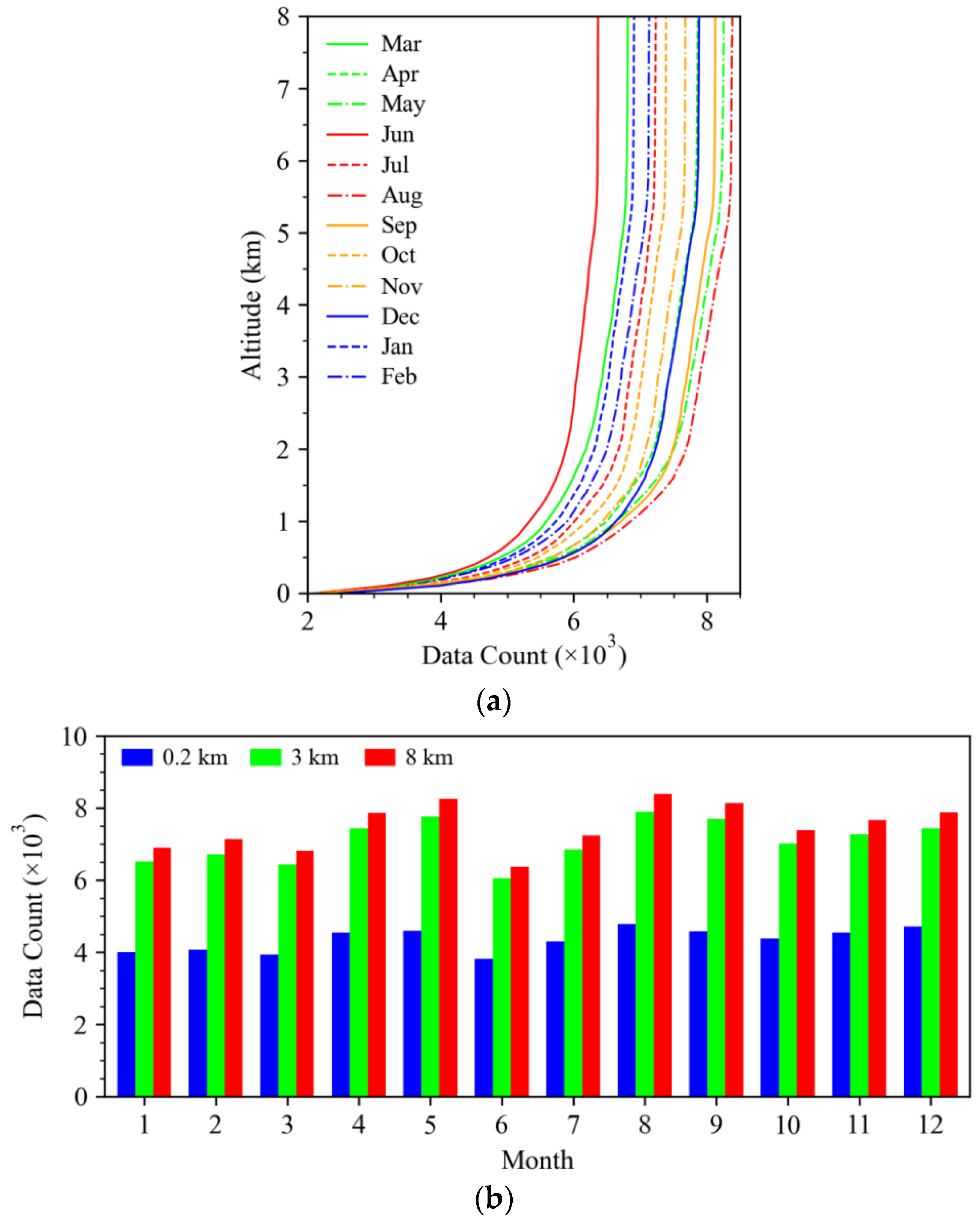
2. Data Description
3. Methodology
3.1. Refractivity and Bending Angle Calculation
3.2. The Spherically Symmetric Refractivity Profile
4. Results
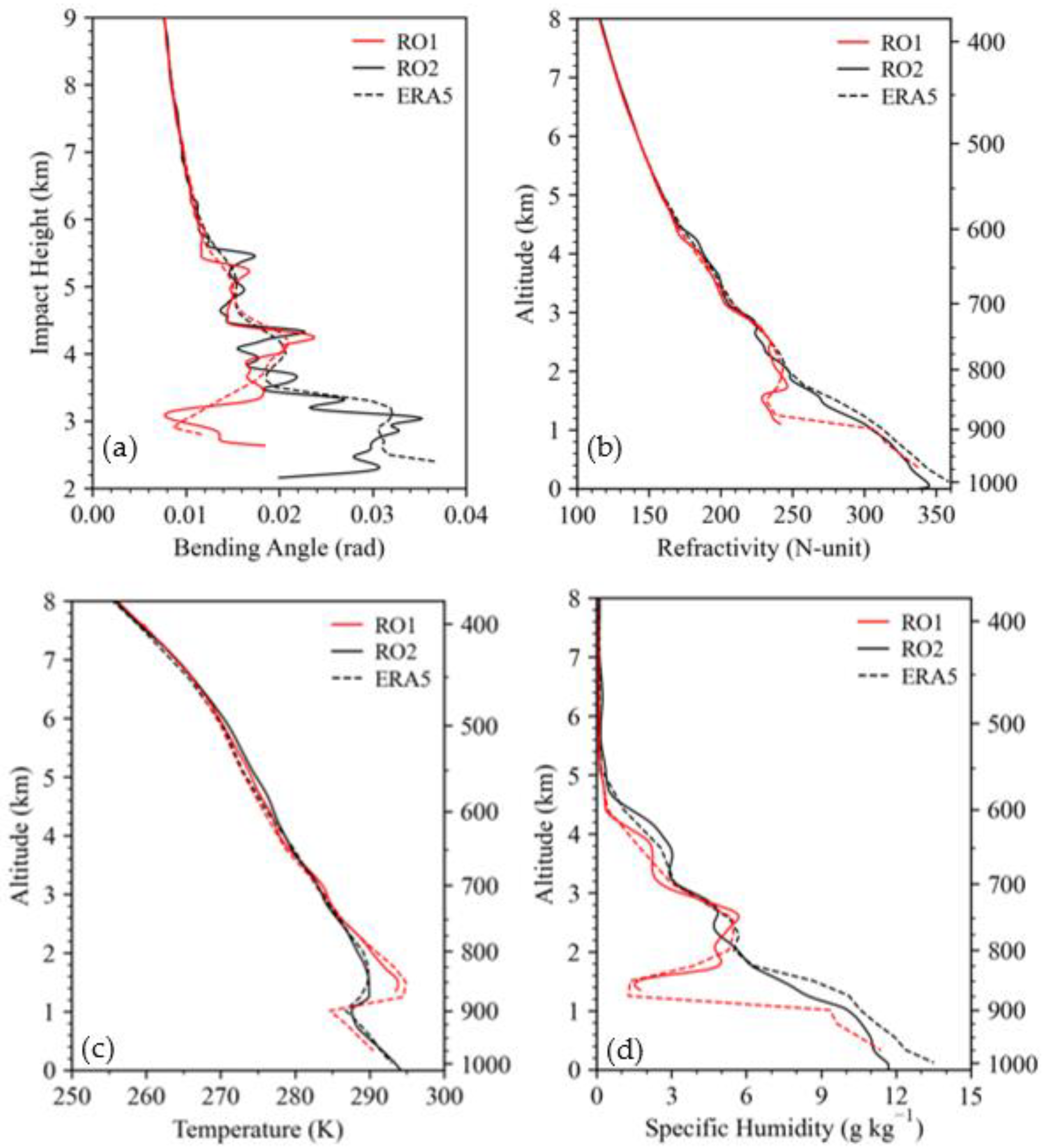
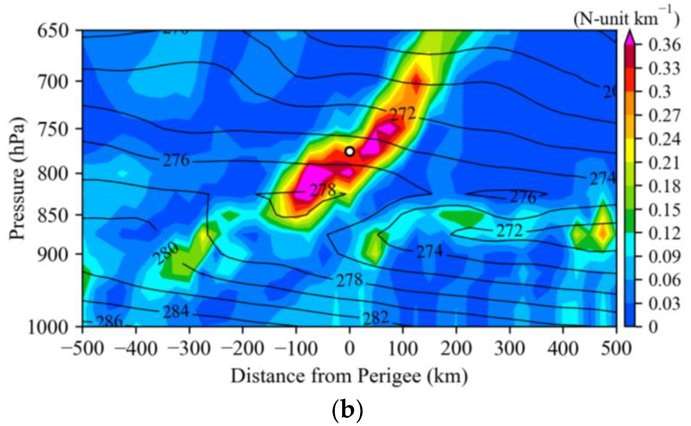
4.1. Two Typical Cases
4.2. Vertical Profiles of Spherically Symmetric Refractivity
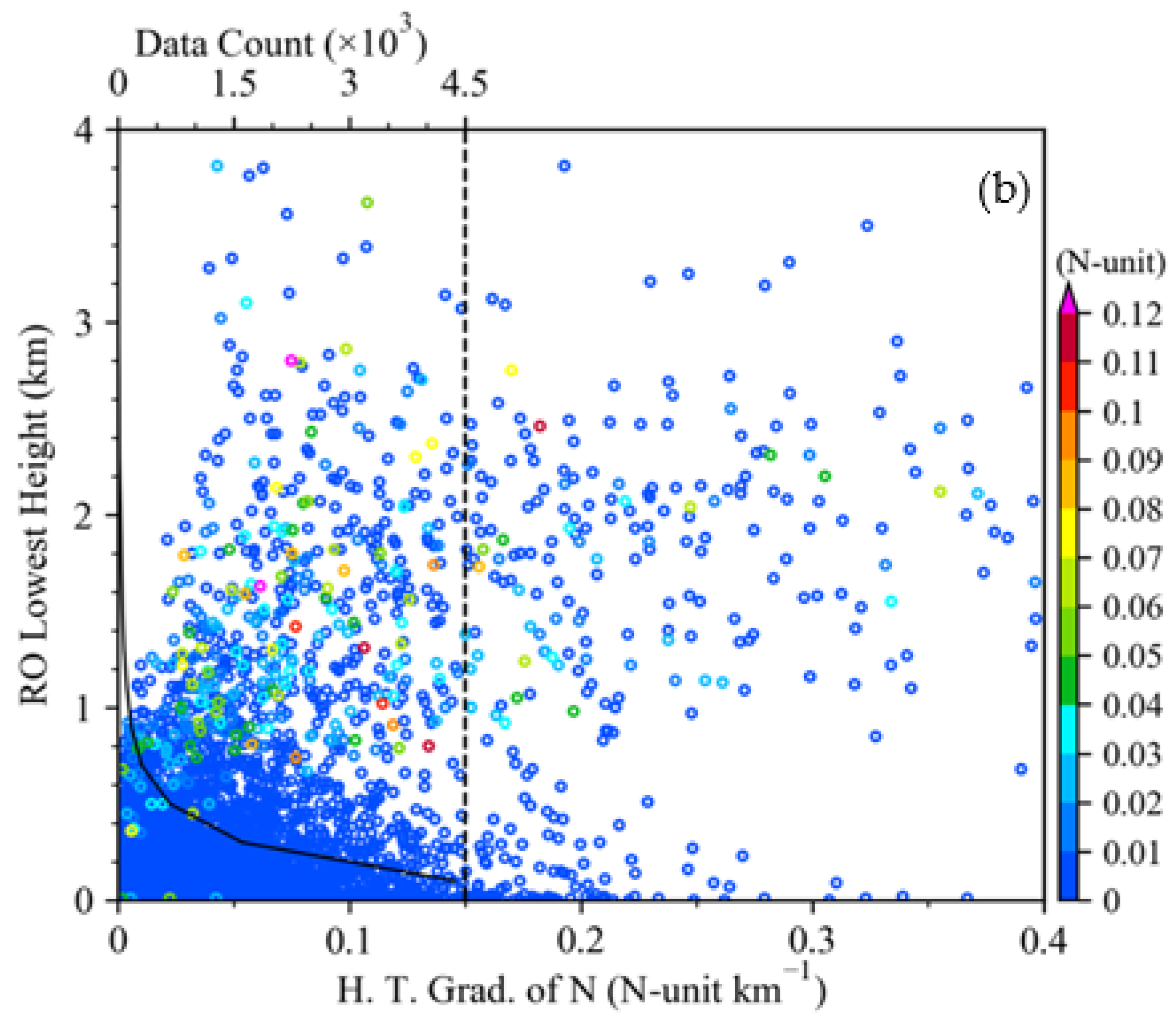
4.3. Statistical Results on the Relationship between the RO Lowest Altitudes and PBL Heights
4.4. Impact of Strong Horizontal Gradient of Refractivity
4.5. Influence of Clouds
5. Discussion
6. Conclusions
Author Contributions
Funding
Data Availability Statement
Acknowledgments
Conflicts of Interest
References
- Ware, R.; Exner, M.; Feng, D.; Gorbunov, M.; Hardy, K.; Herman, B.; Kuo, Y.; Meehan, T.; Melbourne, W.; Rocken, C.; et al. GPS sounding of the atmosphere from low earth orbit: Preliminary results. Bull. Am. Meteorol. Soc. 1996, 77, 19–40. [Google Scholar] [CrossRef] [Green Version]
- Wickert, J.; Reigber, C.; Beyerle, G.; König, R.; Marquardt, C.; Schmidt, T.; Grunwaldt, L.; Galas, R.; Meehan, T.K.; Melbourne, W.G.; et al. Atmosphere sounding by GPS radio occultation: First results from CHAMP. Geophys. Res. Lett. 2001, 28, 3263–3266. [Google Scholar] [CrossRef] [Green Version]
- Hajj, G.A.; Ao, C.O.; Iijima, B.A.; Kuang, D.; Kursinski, E.R.; Mannucci, A.J.; Meehan, T.K.; Romans, L.J.; Torre Juarez, M.; Yunck, T.P. CHAMP and SAC-C atmospheric occultation results and intercomparisons. J. Geophys. Res. Atmos. 2004, 109, D6. [Google Scholar] [CrossRef]
- Wickert, J.; Michalak, G.; Schmidt, T.; Beyerle, G.; Cheng, C.Z.; Healy, S.B.; Heise, S.; Huang, C.Y.; Jakowski, N.; Köhler, W.; et al. GPS radio occultation: Results from CHAMP, GRACE and FORMOSAT-3/COSMIC. Terr. Atmos. Ocean. Sci. 2009, 20, 35–50. [Google Scholar] [CrossRef] [Green Version]
- Anthes, R.A.; Bernhardt, P.A.; Chen, Y.; Cucurull, L.; Dymond, K.F.; Ector, D.; Healy, S.B.; Ho, S.P.; Hunt, D.C.; Kuo, Y.-H.; et al. The COSMIC/FORMOSAT-3 mission-early results. Bull. Am. Meteorol. Soc. 2008, 89, 313–333. [Google Scholar] [CrossRef]
- Schreiner, W.S.; Weiss, J.P.; Anthes, R.A.; Braun, J.; Chu, V.; Fong, J.; Hunt, D.; Kuo, Y.-H.; Meehan, T.; Serafino, W.; et al. COSMIC-2 radio occultation constellation: First results. Geophys. Res. Lett. 2020, 47, e2019GL086841. [Google Scholar] [CrossRef]
- Kursinski, E.R.; Hajj, G.A.; Schofield, J.T.; Linfield, R.P.; Hardy, K.R. Observing Earth’s atmosphere with radio occultation measurements using the Global Positioning System. J. Geophys. Res. Space Phys. 1997, 102, 23429–23465. [Google Scholar] [CrossRef]
- Biondi, R.; Neubert, T.; Syndergaard, S.; Nielsen, J.K. Radio occultation bending angle anomalies during tropical cyclones. Atmos. Meas. Tech. 2011, 4, 1053–1060. [Google Scholar] [CrossRef] [Green Version]
- Biondi, R.; Steiner, A.K.; Kirchengast, G.; Rieckh, T. Characterization of thermal structure and conditions for overshooting of tropical and extratropical cyclones with GPS radio occultation. Atmos. Chem. Phys. 2015, 15, 5181–5193. [Google Scholar] [CrossRef] [Green Version]
- Yang, S.; Zou, X.; Ray, P.S. Comparison of TC temperature and water vapor climatologies between Atlantic and Pacific oceans from GPS RO observations. J. Clim. 2018, 31, 8557–8571. [Google Scholar] [CrossRef]
- Sokolovskiy, S.; Kuo, Y.H.; Rocken, C.; Schreiner, W.S.; Hunt, D.; Anthes, R.A. Monitoring the atmospheric boundary layer by GPS radio occultation signals recorded in the open-loop mode. Geophys. Res. Lett. 2006, 33, L12813. [Google Scholar] [CrossRef] [Green Version]
- Ao, C.O.; Waliser, D.E.; Chan, S.K.; Li, J.-L.; Tian, B.; Xie, F.; Mannucci, A.J. Planetary boundary layer heights from GPS radio occultation refractivity and humidity profiles. J. Geophys. Res. Atmos. 2012, 117, D16117. [Google Scholar] [CrossRef] [Green Version]
- Zou, X.; Vandenberghe, F.; Wang, B.; Gorbunov, M.E.; Kuo, Y.H.; Sokolovskiy, S.; Chang, J.C.; Sela, J.G.; Anthes, R.A. A ray-tracing operator and its adjoint for the use of GPS/MET refraction angle meas- urements. J. Geophys. Res. Atmos. 1999, 104, 22301–22318. [Google Scholar] [CrossRef] [Green Version]
- Zou, X.; Wang, B.; Liu, H.; Anthes, R.A.; Matsumura, T.; Zhu, Y.J. Use of GPS/MET refraction angles in three-dimensional variational analysis. Q. J. R. Meteorol. Soc. 2000, 126, 3013–3040. [Google Scholar] [CrossRef]
- Zou, X.; Liu, H.; Anthes, R.A.; Shao, H.; Chang, J.C.; Zhu, Y.J. Impact of CHAMP radio occultation observations on global analysis and forecasts in the absence of AMSU radiance data. J. Meteorol. Soc. Jpn. 2004, 82, 533–549. [Google Scholar] [CrossRef] [Green Version]
- Healy, S.B. Surface pressure information retrieved from GPS radio occultation measurements. Q. J. R. Meteorol. Soc. 2013, 139, 2108–2118. [Google Scholar] [CrossRef]
- Rennie, M.P. The impact of GPS radio occultation assimilation at the Met Office. Q. J. R. Meteorol. Soc. 2010, 136, 116–131. [Google Scholar] [CrossRef]
- Cucurull, L.; Derber, J.C. Operational implementation of cosmic observations into ncep’s global data assimilation system. Wea. Forecasting. 2008, 23, 702–711. [Google Scholar] [CrossRef]
- Cucurull, L. Improvement in the use of an operational constellation of gps radio occultation receivers in weather forecasting. Wea. Forecasting. 2009, 25, 749–767. [Google Scholar] [CrossRef]
- Cheng, C.; Kuo, Y.-H.; Anthes, R.A.; Wu, L. Satellite constellation monitors global and space weather. Eos Trans. Am. Geophys. Union 2006, 87, 166. [Google Scholar] [CrossRef] [Green Version]
- Li, X.C.; Cheng, X.P.; Fei, J.F.; Huang, X.G.; Ding, J.L. The modulation effect of sea surface cooling on the eyewall replacement cycle in Typhoon Trami (2018). Mon. Wea. Rev. 2022. online ahead of print. [Google Scholar] [CrossRef]
- Ma, Z.H.; Fei, J.F. A comparison between moist and dry tropical cyclones: The low effectiveness of surface sensible heat flux in storm intensification. J. Atmos. Sci. 2022, 79, 31–49. [Google Scholar] [CrossRef]
- Liang, Z.; Ding, J.; Fei, J.; Cheng, X.; Huang, X. Direct/indirect effects of aerosols and their separate contributions to Typhoon Lupit (2009): Eyewall versus peripheral rainbands. Sci. China Earth Sci. 2021, 64, 2113–2128. [Google Scholar] [CrossRef]
- Chen, S.S.; Frank, W.M. A numerical study of the genesis of extratropical convective mesovortices. Part I: Evolution and dynamics. J. Atmos. Sci. 1993, 50, 2401–2426. [Google Scholar] [CrossRef] [Green Version]
- Rogers, R.F.; Fritsch, J.M. Surface cyclogenesis from convectively driven amplification of midlevel mesoscale convective vortices. Mon. Wea. Rev. 2001, 129, 605–637. [Google Scholar] [CrossRef]
- Hendricks, E.A.; Montgomery, M.T.; Davis, C.A. The role of “vortical” hot towers in the formation of tropical cyclone Diana (1984). J. Atmos. Sci. 2004, 61, 1209–1232. [Google Scholar] [CrossRef] [Green Version]
- Sokolovskiy, S.; Schreiner, W.; Zeng, Z.; Hunt, D.; Lin, Y.-C.; Kuo, Y.H. Observation, analysis, and modeling of deep radio occultation signals. Effect of tropospheric ducts and interfering signals. Radio Sci. 2014, 49, 954–970. [Google Scholar] [CrossRef]
- Marquardt, C.; von Engeln, A.; Andres, Y. Deep occultations with GRAS. In Proceedings of the Presentation at 5th FORMOSAT-3/COSMIC Data Users Workshop, Taipei, Taiwan, 13–15 April 2011; Available online: http://www.nspo.org.tw/5th_FS3WS/program_plan.html (accessed on 6 May 2016).
- Zhang, C.; Wang, Y.; Hamilton, K. Improved representation of boundary layer clouds over the southeast pacific in ARW-WRF using a modified Tiedtke cumulus parameterization scheme. Mon. Wea. Rev. 2011, 139, 3489–3513. [Google Scholar] [CrossRef] [Green Version]
- Engeln, A.V.; Nedoluha, G.; Teixeira, J. An analysis of the frequency and distribution of ducting events in simulated radio occultation measurements based on ECMWF fields. J. Geophys. Res. 2003, 108, D21. [Google Scholar] [CrossRef] [Green Version]
- Feng, X.; Xie, F.; Ao, C.O.; Anthes, R.A. Ducting and biases of GPS radio occultation bending angle and refractivity in the moist lower troposphere. J. Atmos. Ocean. Tech. 2020, 37, 1013–1025. [Google Scholar] [CrossRef]
- Ao, C.O. Effect of ducting on radio occultation measurements: An assessment based on high-resolution radiosonde soundings. Radio Sci. 2007, 42, RS2008. [Google Scholar] [CrossRef] [Green Version]
- Bretherton, C.S.; McCaa, J.R.; Grenier, H. A new parameterization for shallow cumulus convection and its application tomarine subtropical cloud-topped boundary layers. Part I: Description and 1D results. Mon. Wea. Rev. 2004, 132, 864–882. [Google Scholar] [CrossRef] [Green Version]
- Wang, Y.; Xie, S.P.; Hu, H.M.; Wang, B. Regional model simulations of marine boundary layer clouds over the southeast Pacific off South America. Part I: Control experiment. Mon. Wea. Rev. 2004, 132, 274–296. [Google Scholar] [CrossRef]
- Zhou, Y.; Liu, Y.; Qiao, J.; Lv, M.; Du, Z.; Fan, Z.; Zhao, J.; Yu, Z.; Li, J.; Zhao, Z.; et al. Investigation on global distribution of the atmospheric trapping layer by using radio occultation dataset. Remote Sens. 2021, 13, 3839. [Google Scholar] [CrossRef]
- COSMIC-2 Data Products, UCAR/NCAR—COSMIC: Boulder, CO, USA, 2019. [CrossRef]
- Hersbach, H.; Bell, B.; Berrisford, P.; Hirahara, S.; Thépaut, J. The era5 global reanalysis. Q. J. R. Meteorol. Soc. 2020, 146, 1999–2049. [Google Scholar] [CrossRef]
- Smith, E.; Weintraub, S. The constants in the equation for atmospheric refractive index at radio frequencies. Proc. IRE 1953, 41, 1035–1037. [Google Scholar] [CrossRef] [Green Version]
- Zou, X. Global Positioning System Radio Occultation Observations; Elsevier BV: Amsterdam, NY, USA, 2020; pp. 175–205. [Google Scholar]
- Sokolovskiy, S.V.; Rocken, C.; Lenschow, D.H.; Kuo, Y.H.; Anthes, R.A.; Schreiner, W.S.; Hunt, D.C. Observing the moist troposphere with radio occultation signals from COSMIC. Geophys. Res. Lett. 2007, 34, L18802. [Google Scholar] [CrossRef] [Green Version]
- Zou, X.; Liu, H.; Kuo, Y.-H. Occurrence and detection of impact multipath simulations of bending angle. Quart. J. Roy. Meteor. Soc. 2019, 145, 1690–1704. [Google Scholar] [CrossRef]
- Yang, S.; Zou, X. Relationships of along-the-track local variations of GPS RO impact parameter to strong local vertical gradient of wet refractivity in the tropics. Sci. China Earth Sci. 2021, 64, 1–11. [Google Scholar] [CrossRef]
- Yang, S.; Zou, X.; Anthese, R. Raytracing simulated GPS radio wave propagation paths experiencing large disturbances when going through the top of the sub-cloud layer. Remote Sens. 2021, 13, 4693. [Google Scholar] [CrossRef]
- Yang, S.; Zou, X. Lapse rate characteristics in ice clouds inferred from GPS RO and CloudSat observations. Atmos. Res. 2017, 197, 105–112. [Google Scholar] [CrossRef]
- Zou, X.; Yang, S.; Ray, P. Impacts of ice clouds on GPS radio occultation measurements. J. Atmos. Sci. 2012, 67, 36703682. [Google Scholar] [CrossRef]


Publisher’s Note: MDPI stays neutral with regard to jurisdictional claims in published maps and institutional affiliations. |
© 2022 by the authors. Licensee MDPI, Basel, Switzerland. This article is an open access article distributed under the terms and conditions of the Creative Commons Attribution (CC BY) license (https://creativecommons.org/licenses/by/4.0/).
Share and Cite
Xu, X.; Zou, X. COSMIC-2 RO Profile Ending at PBL Top with Strong Vertical Gradient of Refractivity. Remote Sens. 2022, 14, 2189. https://doi.org/10.3390/rs14092189
Xu X, Zou X. COSMIC-2 RO Profile Ending at PBL Top with Strong Vertical Gradient of Refractivity. Remote Sensing. 2022; 14(9):2189. https://doi.org/10.3390/rs14092189
Chicago/Turabian StyleXu, Xu, and Xiaolei Zou. 2022. "COSMIC-2 RO Profile Ending at PBL Top with Strong Vertical Gradient of Refractivity" Remote Sensing 14, no. 9: 2189. https://doi.org/10.3390/rs14092189
APA StyleXu, X., & Zou, X. (2022). COSMIC-2 RO Profile Ending at PBL Top with Strong Vertical Gradient of Refractivity. Remote Sensing, 14(9), 2189. https://doi.org/10.3390/rs14092189