Abstract
Beach morphology can be observed over large spatio-temporal scales, and future shoreline positions can be predicted and coastal risk indicators can be derived by measuring satellite-derived instantaneous waterlines. Long-term satellite missions, such as Landsat and Sentinel-2, provide decades of freely available, high-resolution optical measurement datasets, enabling large-scale data collection and relatively high-frequency monitoring of sandy beaches. Satellite-Derived Shoreline (SDS) extraction methods are emerging and are increasingly being applied over large spatio-temporal scales. SDS generally consists of two steps: a mathematical relationship is applied to obtain a ratio index or pixel classification by machine-learning algorithms, and the land/sea boundary is then determined by edge detection. Indexes from lake waterline detection, such as AWEI or NDWI, are often transferred towards the shore without taking into account that these indexes are inherently affected by wave breaking. This can be overcome by using pixel classification to filter the indices, but this comes at a computational cost. In this paper, we carry out a thorough evaluation of the relationship between scene-dependent variables and waterline extraction accuracy, as well as a robust and efficient thresholding method for coastal land–water classification that optimises the index to satellite radiometry. The method developed for sandy beaches combines a new purpose-built multispectral index (SCoWI) with a refinement method of Otsu’s threshold to derive sub-pixel waterline positions. Secondly, we present a waterline extraction pipeline, called Shoreliner, which combines the SCoWI index and the extraction steps to produce standardised outputs. Implemented on the CNES High Performance Cluster (HPC), Shoreliner has been quantitatively validated at Duck, NC, USA, using simultaneous Sentinel-2 acquisitions and in situ beach surveys over a 3-year period. Out of six dates that have a satellite acquisition and an in situ survey, five dates have a sub-pixel RMS error of less than 10 m. This sub-pixel performance of the extraction processing demonstrates the ability of the proposed SDS extraction method to extract reliable, instantaneous and stable waterlines. In addition, preliminary work demonstrates the transferability of the method, initially developed for Sentinel-2 Level1C imagery, to Landsat imagery. When evaluated at Duck on the same day, Sentinel-2 and Landsat imagery several minutes apart provide similar results for the detected waterline, within the method’s precision. Future work includes global validation using Landsat’s 40 years of data in combination with the higher resolution Sentinel-2 data at different locations around the world.
1. Introduction
Sandy coasts around the world are among the most dynamic geological features, always moving towards a natural equilibrium with the environmental forces to which they are exposed. This natural morphodynamic behaviour is often controlled by human intervention, with the aim of dictating our coastal environment so that it becomes predictable and manageable. It is this anthropogenic pressure that lies at the root of concepts such as coastal risks/hazards and solutions such as hard coastal structures [1]. Without this anthropogenic pressure, there is only the natural movement of the shoreline (as the instantaneous waterline corrected for hydrodynamic influences) at different spatio-temporal scales. Erosion and accretion often have a direct impact on the populations that depend on and live near the sea. As a general concept, the position of the shoreline is a solid proxy (not a holistic view) for the health and degree of protection of the beach; the wider the beach, the greater the buffer between the land and the sea, and therefore the greater the protection from environmental conditions and the lower its (flood) risk. Therefore, measuring the instantaneous waterline allows us to observe natural morphology [2], predict future shoreline positions [3] and derive coastal risk indicators.
It is important to note that answering different shoreline-related questions requires different and appropriate spatio-temporal scales of data [4]. Where the shoreline can be measured by GPS, it cannot be expected to be measured at high frequencies (e.g., hourly). Shore-based video camera systems can provide a shoreline position (averaged instantaneous waterline in time—or exposure) almost instantaneously every 10 min, but they only cover local scales. Satellites can provide an appropriate medium between the two, with freely available global optical satellite data now acquired at least every 5 days, and by combining a group of satellites this can theoretically be brought down to near daily data acquisition. So where it used to take a lot of financial and human resources to take occasional measurements of coastal indicators such as the shoreline, we now have the data and infrastructure to analyse a local beach using a simple laptop with an internet connection and can scale up to regional and even global studies using powerful cluster infrastructures. Long-term satellite missions, such as Landsat and Sentinel-2, provide more than 40 years of freely accessible medium-resolution optical imagery, enabling comprehensive coastal studies at different spatio-temporal scales [5]. For example, [6] continental-scale changes in Australia’s dynamic coastal zones have been accurately quantified using Satellite-Derived Shoreline (SDS) data extracted from Landsat data.
We alternate between the terms shoreline and waterline, as the attentive reader may have noticed. The shoreline can be defined in several ways. In this paper, we focus on determining the instantaneous waterline at the moment the satellite image is acquired, while the shoreline can be estimated using non-optical data such as Synthetic Aperture Radar (SAR) [7,8,9]. In this work, we focus only on optical satellites and we assume that the entire satellite image is acquired at the same time (which is not the case and can be 20–40% of a typical swash period [10]). The number of publications attempting to extract the shoreline (or waterline) from multispectral optical satellite imagery has increased radically [11]. Optical satellite imagery is typically used to create indices, such as the widely used NDWI (Normalised Difference Water Index) or AWEIsh (Automated Water Extraction Index), which are thresholded to determine the land/sea boundary. Conceptually, this is what implementations such as CoastSat [12], CASSIE [13], PyIntertidalDEM [14] and ECFAS [15] use to find the instantaneous waterline, with differences in workflow and accessibility. Unfortunately, when applied to many coastal environments, none of the methods have proven to be simultaneously robust, fully automated and fast enough [11]. Even when considering beach-scale applications, state-of-the-art SDS extractors perform best over 30–40% of the coastline. To improve the accuracy of an extractor’s SDS extraction, it is imperative to thoroughly evaluate the relationship between scene-dependent variables and shoreline accuracy [16]. Here, we aim to fully automatically detect the coastline as accurately and computationally efficient as possible by creating a radiometric optimised indicator and integrating it into the CNES-HPC. Initially, we will start with Sentinel-2 data, as all Sentinel-2 satellite data are directly available to the computational core of the CNES-HPC, allowing for large spatio-temporal scale applications within a reasonable time frame.
In the following sections, we outline the optimisation of a radiometric index to optimally separate land and sea, using previous knowledge from a variety of approaches. We present the processing pipeline to extract the water index and find the optimal land–sea boundary. The method is developed mainly on the Atlantic coast of France and then validated without modification around the FRF at Duck, USA. The discussion section discusses the limits, large-scale applications in other parts of the world such as Saint Louis in Senegal and the transferability to other optical satellite sensors, in particular, the Landsat series, and is followed by the conclusions.
2. Methods
2.1. Water Indices: A Separation between Land and Sea
In general, satellite-derived indices using a range of colour bands are often used to identify, measure, track and analyse natural processes. Water indices are more commonly used to distinguish water from land, to detect lakes, rivers and floods, and similarly in the coastal zone to detect the instantaneous waterline. Probably one of the most widely used and well known indices for distinguishing land from water is the Normalised Difference Water Index (NDWI) [17,18] using NIR and green or NIR and SWIR (Short Wave Infrared band). The NDWI, and its close relative the MNDWI [19], are ratio-based indices. Normalisation has its advantages; it is less affected by variations in radiometric response, but it also has disadvantages. For example, pansharpening is less effective because the ratio of the colour bands (the index), and hence the spatial resolution, remains the same, even when pansharpened. For example, in CoastSat (checked on v2.0) they opt for bi-linear interpolation of the colour bands before pan-sharpening, which is essential to smooth the result and increase the resolution. Another type of index is an RGB composition, a combination of bands in the false RGB colour space, which is often used to detect inland water bodies [20]. Using the RGB composite of bands results in a single image that can be converted to a greyscale image using colourimetric analysis to separate land from sea. Such a method is used in Khan et al. [14] to extract water lines at different stages of the tide in the vast coastal region of the Bay of Bengal delta.
Alongside these two types of approaches, we find subtractive indices: AWEI (Automated Water Extraction Index) [21] and Water Index (WI) [22]. These indices are not ratios or normalised and can therefore be used in a pan-sharpened fashion. Subtractive indices typically rely on higher spectral resolution (radiometry), or in other words more spectral bands, which are often not available on very high resolution satellites such as Pleiades or Worldview. Although developed for Landsat, the AWEI is also a reliable index that can be applied to Sentinel-2. It can be used to enhance the spectral contrast, which is more effective than the MNDWI in separating land from water around a value of 0. There are two types of AWEI: AWEI for images with shadows (AWEIsh) and and without shadows (AWEInsh) [21].
where B is the blue band (490 nm for Sentinel-2), G is green (560 nm), NIR is the near infrared band (842 nm) and SWIR1 and SWIR2 are the shortwave infrared bands with wavelengths of 1610 nm and 2190 nm, respectively. In terms of waterline extraction, the AWEI appears to be more accurate compared to normalised indices for a variety of environments such as sandy beaches, artificial coastlines, rocky coastlines, wetlands and mudflats. This can be explained by the fact that subtractive indices such as AWEI have a linear response to the fractional composition of land and water within a pixel, whereas the response of a ratio-based index such as NDWI and MNDWI is non-linear [23]. However, although the AWEI outperforms the normalised indices, it is not radiometrically optimised to detect the waterline in wet swash areas. Often, the AWEInsh classifies rocks and dark landmasses as water, and while the AWEIsh performs better than the AWEInsh, the AWEIsh tends to classify wet sand areas as water. It is precisely in this area, around the waterline in the swash zone during falling tides and/or on very dissipative flat beaches, where wet sand areas are abundant in the intertidal zone. Based on the AWEIsh, the following sections explore a radiometric optimisation that overcomes the shoreward bias of the AWEIsh to robustly and fully automatically detect the instantaneous waterline.
2.1.1. Radiometric Response in the Intertidal Zone and Optimisation
To understand the radiometric responses per spectral band in the coastal zone and the effect on the subtractive index, we examine the spectral response across a cross-shore line, as shown by the thick red line in the left panel of Figure 1. Using the spectral bands of AWEIsh, the individual band responses across the cross-shore line from sea to land are shown. Over the cross section, five zones are identified in shoreward order: water, white water where waves break, wet sand, dry sand and land (in the case of Figure 1, it is vegetation, but this is not a prerequisite). For this analysis, we used the Sentinel-2 MSI Level1C product, which provides the reflected radiance, where blue, green, near infrared (NIR) and shortwave infrared 1 and 2 (SWIR1, SWIR2) correspond to bands B02, B03, B08, B11 and B12, respectively.
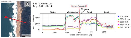
Figure 1.
Cross-shore coastal spectral response. The cross-shore distance origin is set on the red cross at the seaward edge of the transect.
Figure 1 shows that each zone has its characteristic spectral signature. Some clear patterns can be seen; for example, on water the spectral response in the NIR and SWIR bands is close to zero, as water absorbs most of the photons in these ranges, while as we hit land the response in the infrared channels increases. For the visible bands, the blue and green, there is a greater but medium (∼1200) radiance. As the waves break closer to the shore, creating foam, the spectral response is high in the blue, green and NIR bands (∼4500), but remains low for the SWIR bands (≤1000). The NIR band in particular shows a sudden increase in reflected radiance. It is worth noting that for the water zones (water + white water) the blue and green bands are always higher than all the infrared bands.
When we hit land, in this case wet sand, the latter observation is no longer valid: the infrared bands show a greater response compared to the green and blue bands. The SWIR bands characteristically increase their response progressively around this zone. The cross-shore location where the NIR response exceeds that of the blue and green bands indicates the boundary corresponding to the instantaneous waterline. Further landwards, the sand zone shows a medium response for the blue and green bands (∼2000), but also a high response of the three infrared bands. Finally, the land zone shows a medium response for all bands (∼1000). On land, the NIR generally has a greater response than any of the other bands, but we note that the NIR also has a greater variability (noisier) compared to the other bands.
In conclusion, the Sentinel-2 Level1C imagery shows a clear boundary corresponding to the instantaneous waterline, namely the transition between a greater response of the blue and green bands on the water side and a greater response of the NIR band on the land side.
2.1.2. SCoWI: Optimised Water Index for Coastal Zones
Given our objective to distinguish water from land as well as possible, the index used should aim to have a maximum but balanced difference in index values for land and sea, namely two different Gaussian distributions (bimodal distribution) and a minimum (around 0) for the interface. To achieve this, we perform a radiometric/index optimisation. Using the AWEIsh as a starting point, the mean AWEIsh per environment can be calculated. To ensure robustness, four different arbitrarily selected coastal sites are combined in this analysis. The mean AWEIsh values for all sites per zone are represented by the blue vertical bars in Figure 2.
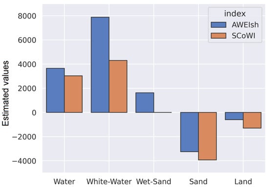
Figure 2.
Comparison of SCoWI estimated values (orange bars) with AWEIsh (blue bars) over the five intertidal environments. SCoWI has lower estimated values than AWEIsh in the white water and wet sand area, optimising the land/water classification on sandy beaches by setting its boundary at the waterline.
Whilst theoretically aiming to be around 0, the values found for wet sand are remarkably high, around 1800, and so, following the theory, these pixels are considered to be water. Consequently, in the coastal zone where wet sands are present, the AWEIsh is likely to estimate the instantaneous waterline landward of the actual waterline. In addition, white-water is obviously overestimated given the excessively high value in Figure 2. This overvaluation could form an unbalanced third mode, which is not ideal for the application of an automatic thresholding method that assumes a bimodal distribution.
Starting from the AWEIsh, one can iteratively optimise the coefficients to obtain a well-balanced distribution (reducing the overestimation of white water) where wet sand is closer to land values and around zero. Keeping the same bands as the AWEIsh, an optimised expression is found that achieves our objective of emphasising the waterline interface, and we call it the “Subtractive Coastal Water Index” or SCoWI:
Using Equation (3), the same exercise as above is repeated, and the results are represented by the orange vertical bars in Figure 2. In general, lower absolute values are found for each zone (≈−600), but the distribution is significantly more balanced and well zeroed across the water–land interface. Compared to AWEIsh, SCoWI gives more weight to the NIR response and less to the green band. This is to highlight the transition between white water and wet sand where the NIR response becomes greater than the visible bands: the instantaneous waterline. In addition, the SWIR bands allow the SCoWI response to be adjusted and the balance of the distribution to be fine-tuned.
2.2. Waterline Extraction Pipeline: Shoreliner
An index is only part of the overall process of using satellite imagery to extract the instantaneous waterline. This section presents the process used to extract the instantaneous waterline from Level1C Sentinel-2 optical satellite imagery. Following the method proposed by [23], a refined and robust method using the previously presented SCoWI and a new histogram thresholding procedure to extract the sub-pixel waterline is described. The method itself is implemented as a Python API on the CNES HPC. When we refer to the whole processing, we refer to Shoreliner.
2.2.1. Sentinel-2 Imagery and Pre-Processing
As mentioned above, we use Level1C Sentinel-2 satellite optical imagery for this work, as all Level1C products are directly available on the CNES HPC and do not depend on the choice of atmospheric correction routine applied. The Sentinel-2 MultiSpectral Instrument (MSI) measures the solar photons reflected by the Earth, radiance, which is converted to reflected radiance in the Level1C product. Sentinel-2 has a view angle close to nadir and the images are acquired simultaneously in 13 spectral bands with varying resolutions between 10, 20 and 60 m. The Sentinel-2 mission will provide systematic multispectral coverage of all land areas between 56° South (Cape Horn in South America) and 84° North (north of Greenland), including large islands (greater than 100 km2 in size), European islands and all other small islands less than 20 km from the coastline. Sentinel-2 has a revisit time ranging from 5 days at the equator to 1 day at the highest latitudes [24], and at the coasts this results in a variety of revisit times depending on the location [25].
Systematically acquired and processed Sentinel-2 Level1C products are radiometrically and geometrically corrected, including orthorectification and spatial registration to a global reference system. Each pixel represents a radiometric measurement at the top of the atmosphere (TOA) in reflectance. New imagery is typically available within 3 to 24 h, enabling near real-time to non-time-critical analysis. Minimal pre-processing of the Level1C Sentinel-2 data is required before we can use it for an SCoWI estimate. The resolution of all bands is equalised by downsampling the 20 m SWIR bands to 10 m resolution using cubic interpolation. In addition, a cloud mask is calculated by combining the cirrus and opaque cloud masks provided with the Sentinel-2 Level1C products.
2.2.2. Waterline Detection and Extraction
Once a Sentinel-2 product has been pre-processed, the SCoWI is computed using Equation (3), resulting in an unbounded greyscale image. The calculated cloud and no-data masks are applied to this greyscale image to remove erroneous pixels for our target and processing. Theoretically, pixel values greater than 0 represent water pixels and the image should have a bimodal distribution histogram. However, for fully automatic robustness, the instantaneous waterline is often detected using adaptive thresholding techniques such as Otsu’s method [23,26]. Otsu’s method can be applied under the assumption that the SCoWI greyscale image has a bimodally distributed histogram, as Otsu’s threshold is determined by minimising the intra-class variance, , of a list of values that have a bimodal distribution [27].
For each greyscale image at a given date, we take as the minimum SCoWI value obtained and as the maximum SCoWI values. Then, the Otsu threshold is given by:
Unfortunately, although mathematically correct, given the application here, it is likely that the Otsu threshold will lack accuracy in cutting the two distributions on the histogram, considering that the histogram can be affected by the size of the scene around the coastline and the percentage/distribution of land/sea pixels. Or, for example, at low tide, which is often a challenge for SDS methods due to the abundance of wet sand patches that affect the instantaneous waterline detection [28]. When using the AWEIsh, these wet sand patches are detected as water, resulting in a landward observation of the instantaneous waterline and a change in the index distribution. Similar problems are reported using MNDWI in Vos et al. [26].
Physically, the threshold should lie between the two distributions where both modes combined are minimum. In addition to the original Otsu method, the minimum histogram condition around the Otsu threshold, called local minimum histogram thresholding, is introduced to improve the threshold to be close to the effective instantaneous waterline. After calculating the Otsu threshold on the SCoWI histogram using Equation (4), local maxima are calculated and selected to define an interval, , on either side of the Otsu threshold, such that , where and and are local maxima of the histogram. Finally, the local minimum threshold is defined as the minimum argument of the histogram in the interval . In this way, we ensure that the computed threshold, which separates the two distributions as closely as possible, actually minimises the intra-class variance of the histogram. Three approaches, AWEIsh, SCoWI with Otsu and SCoWI with optimised minimum search, are presented in Figure 3 to illustrate the respective contributions in practice.
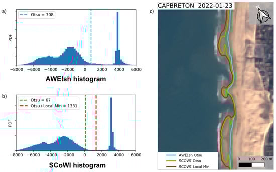
Figure 3.
(a) AWEIsh histogram of this Sentinel-2 acquisition. The dashed blue line is the Otsu threshold value computed for this histogram. (b) SCoWI histogram of this Sentinel-2 acquisition in which the dashed green line indicates the Otsu threshold value while the dashed red line shows the position of the local histogram minimum. (c) Sentinel-2 acquisition at Capbreton, French Atlantic coast, during low tide. Instantaneous waterlines are extracted through the three methods: cyan is AWEIsh, green represents the SCoWI with Otsu and red shows the SCoWI with local minimum approach. Waterline extracted by the SCoWI combined to the local minimum histogram thresholding method is represented by the red line.
A threshold can now be found from which the exact coordinates of the instantaneous waterline can be deduced. If this is done directly on the single greyscale image, it will result in a stepped pixel waterline, which is linked to the resolution of the satellite optical imagery (in this case, 10 m). To overcome this problem, a sub-resolution marching square mapping algorithm using the effective local minimum threshold is applied to the SCoWI image, as presented in Vos et al. [26]. A key hypothesis is that pixels at 10 m resolution along the waterline represent a mixture of water and land, and that the water index values for these pixels directly reflect the relative proportion of water and land within these pixels [23]. If this is the case, the four neighbouring pixels can be taken into account to find the position of the threshold line more accurately, rather than simply drawing a line directly at the centre or edges of the thresholded pixels. The marching square algorithm linearly interpolates the SCoWI values of neighbouring pixels to map the exact location of the waterline according to the specified threshold [29].
3. Validation
So far, all the manipulations discussed above have been developed at sites along the European mainland and its overseas territories. However, there are few sites in the world, virtually none other than ERDC’s Field Research Facility (FRF) at Duck, NC, USA, that have the temporal density of direct measurements (not video-derived shoreline proxies) to adequately validate the performance of the above waterline extraction procedure. Hydrodynamics are consistently measured day and night, and monthly to bi-weekly high quality in situ topo-bathymetric surveys have been conducted at the FRF [30] since 1981. The National Oceanic and Atmospheric Administration (NOAA) installed a water level sensor in 1978 that measures water level hourly, and since 1995 an upgraded station measures sea level every 6 min [31]. From the measured bathymetry and the instantaneous near-shore water level (within 6 min—effectively 3 min) on a given day and time, we derive an instantaneous reference waterline. This reference waterline is projected into the same coordinate system as the Sentinel-2, before being compared to our instantaneous waterline measured from the Sentinel-2 acquisition on the same day.
Equidistantly spaced cross-shore transects, 5 m apart, were established along the coast over the area of the bathymetric surveys. On each transect we compared the position of the instantaneous waterline extracted using Shoreliner, with the cross-shore position of the waterline derived using the beach survey and local water level measurement combined on the same transect. It should be noted that the data at the FRF was not from one of the representative beaches used to optimise SCoWI, and therefore serves as a cross-validation of the optimisation.
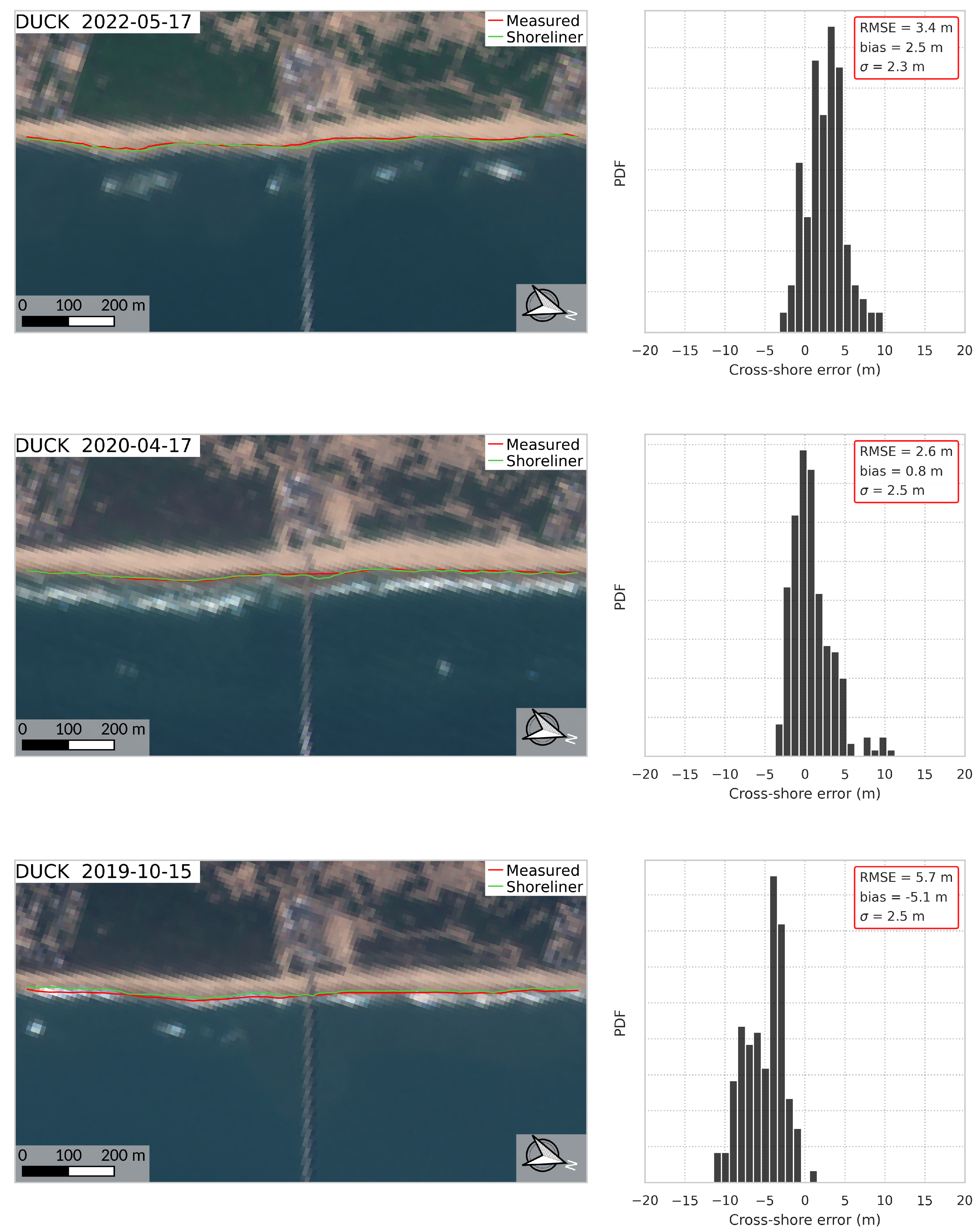
For validation, we focus on a 3-year period, from August 2019 to August 2022, over which 106 waterlines could be estimated, taking into account cloud cover, etc. (which is consistent with [25]). Of these 106 Sentinel-2 acquisitions, only 6 occurred on the same day as an in situ topo-bathymetric survey at Duck. Figure 4 shows three of these results over the 3 years. The other three results can be seen in Figure A1 of Appendix A. At best, over these six dates, we find that Shoreliner is able to estimate the instantaneous waterline with an RMS error of 2.6 m, a bias of 0.8 m and a standard deviation of 2.5 m. Of the six dates that have both a satellite acquisition and an in situ survey, five dates have a sub-pixel RMS error of less than 10 m. This sub-pixel performance of the extraction processing demonstrates the ability of the proposed SDS extraction method to extract reliable, instantaneous and stable waterlines.
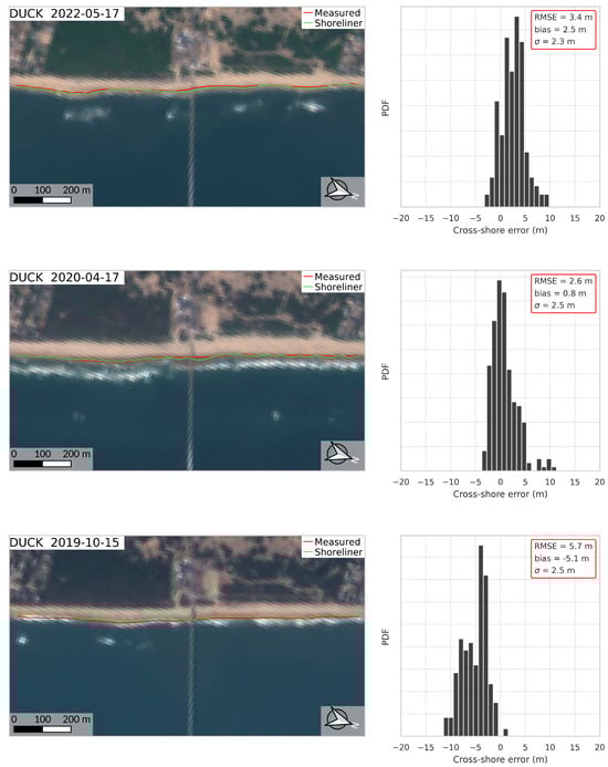
Figure 4.
Comparison of the waterline extracted using Shoreliner, the SCoWI-based extraction method proposed in this paper (green line), with the in situ measured waterline (red line) at Duck (USA). The right-hand side histograms display the positional error between the extracted and measured waterline. The smallest cross-shore RMS error achieved a value of 2.6 meters, corresponding to 1/4 of the Sentinel-2 pixels.
When compared to a state-of-the-art SDS extraction method, CoastSat [26], Shoreliner produces comparable or better results than CoastSat. Taking the Sentinel-2 imagery from the 3-year period studied, Shoreliner has an RMS error of 8.3 m versus 19.1 m for CoastSat, a bias of 3.6 m landward versus 15.1 m seaward and a standard deviation of 7.4 versus 11.8 m. This study shows similar statistics found by [32] for instantaneous waterlines extracted by CoastSat on a meso- to macrotidal beach.
In terms of computation time, using identical computing nodes (16 cores at 2.1 GHz—Intel Cascadelake), available memory and Sentinel-2 scenes covering 348 km2, Shoreliner completed the computation in 2.237 s, while CoastSat took 27.873 s, as shoown in Table 1. In terms of computational efficiency, Shoreliner is 12.5 times faster. This is mainly due to the absence of pixel classification in Shoreliner compared to CoastSat, which is computationally expensive. For large-scale applications, this is an important factor to enable regional or even large-scale shoreline estimation.

Table 1.
Comparative performance of Shoreliner, the SCoWI-based extraction method proposed in this paper, and the state-of-the-art SDS extraction method, CoastSat, obtained around the FRF at Duck, USA, over a period between August 2019 and August 2022.
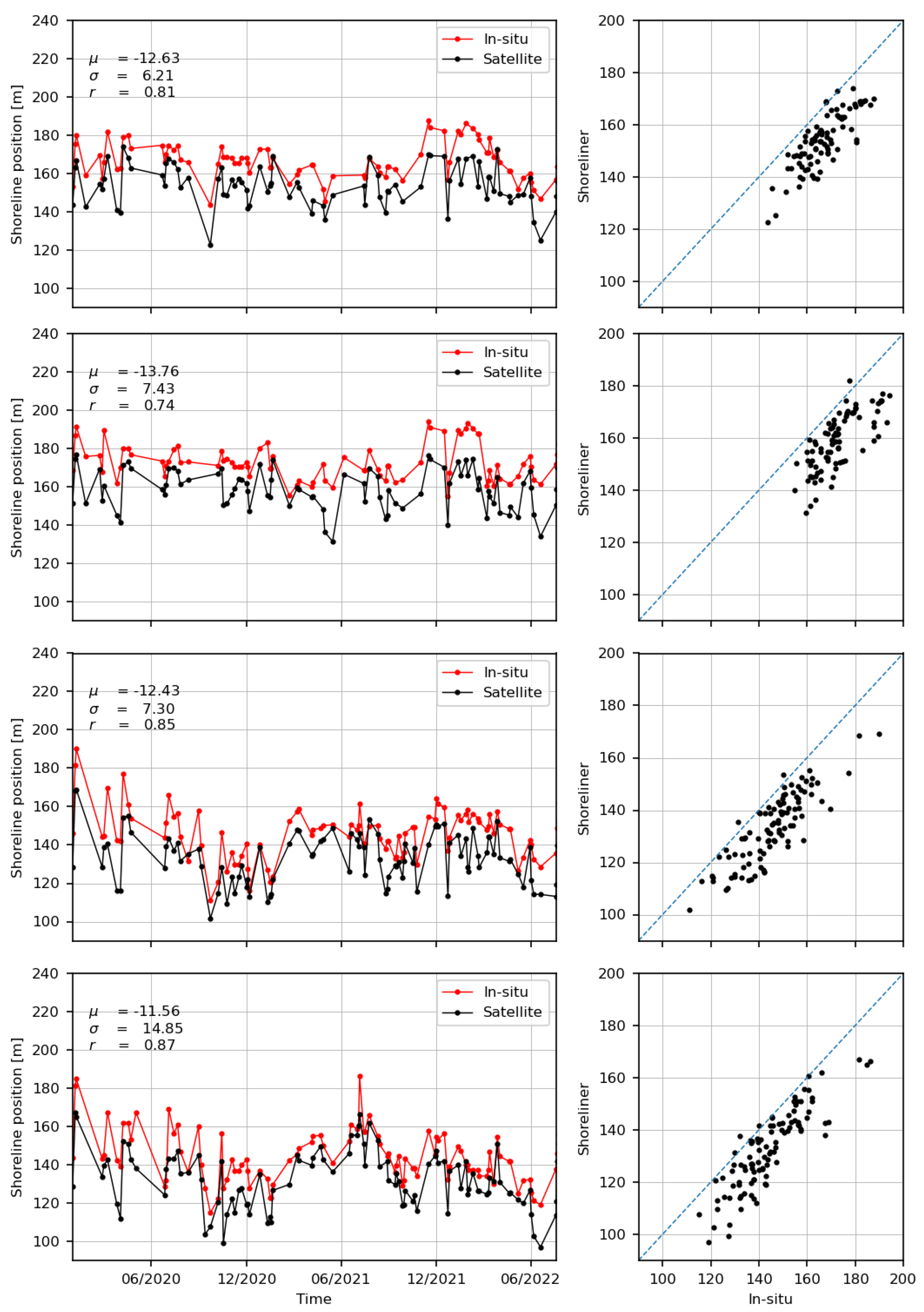
In addition to the individual simultaneous surveys and satellite passes, a form of spatial validation, we use time series analysis to assess performance over time. Similar to the satellite-derived shoreline benchmark in Vos et al. [33], we use the in situ measured profile data (profile numbers −91, 1, 1006 and 1097) at Duck in combination with the measured water level at the pier to compare the resulting waterline position (in situ in red) and the satellite detected waterline positions (black); as shown in Figure 5. For all transects, it is evident that the satellite-derived results are well correlated (r in Figure 5), with the in situ data considering the range of correlation coefficients between 0.74 and 0.87 and an average correlation coefficient of 0.81. Figure 5 also shows the mean offset and standard deviation. In general, we find a negative bias over these 3 years, i.e., the satellite-derived shoreline is generally seaward of the in situ shoreline, with a time average mean bias of 12.6 m. As mentioned above, such a negative bias is not uncommon and may be related to run-up, tidal correction and other hydrodynamic processes [34] which are not considered here (tidal correction only). Despite the average bias, the high correlation coefficient shows that Shoreliner is able to capture the in situ variability, which is arguably more important for coastal and climate studies than the bias, while the bias needs to be understood and is the subject of future work.
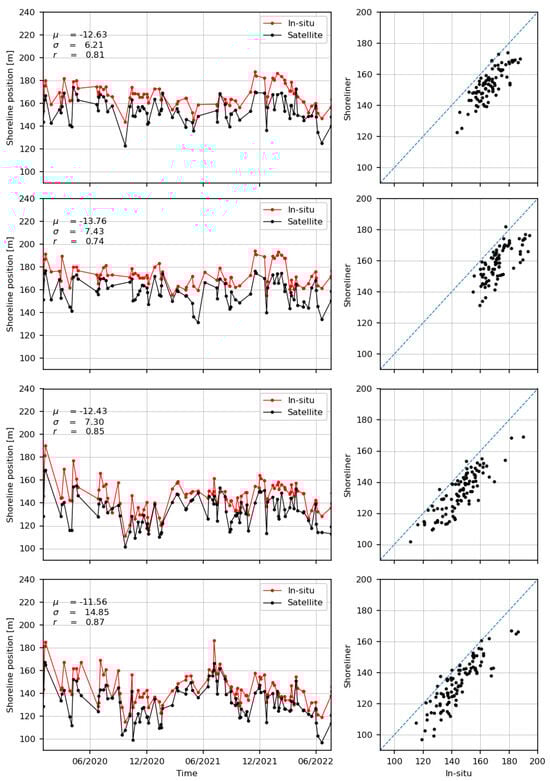
Figure 5.
Comparison of the waterline extracted using Shoreliner (red line) at Duck (USA) for profiles −91, 1, 1006 and 1097 (top to bottom).
4. Results and Discussion
Individual dates show good performance, and similar to Vos et al. [12], each date can be coupled to a tidal elevation, e.g., the CNES AVISO+ FES model, to reconstruct an intertidal topography, evaluate beach slopes and correct the waterline position for tidal influences and run-up, and then derive a shoreline. These corrections are considered essential here and, of course, the same corrections apply directly to our instantaneous waterline.
4.1. Large-Scale Applications
Recent trends in waterline detection show the importance of local applications to validate and better understand the performance of waterline detection, after which the same methods are extended to larger spatio-temporal scales [35]. Although the waterline is a first-order approximation of morphological changes, coastal variability and climate impacts, it provides very valuable insight into the impact of example climate modes on the coastal zone, even in areas that are traditionally data poor, such as most of Africa [36].
Consider St. Louis in Senegal, a storm-free environment subject to the dominance of bidirectional, very energetic swells originating from far away in the northern or southern Atlantic Ocean. Most of the time, the northern component dominates, resulting in a very strong alongshore transport and migrating sand spit (called Langue de Barbarie) towards the south [37,38]. In 2003, an artificial breach was made in the sand spit to protect the city of St. Louis from the extreme water levels on the mainland. Since 2018, St. Louis has been regularly monitored to understand the morphodynamics and better adapt to future changes. Interestingly, the beach in front of the city of St. Louis was in its most eroded state at this time, with the beach virtually disappearing, leaving fishermen’s houses and support facilities exposed to the elements. After 2019, a strong accretion was observed, a perfect case to test our waterline detection.
In this case, we use all available Sentinel-2 images until 2022. The CNES High-Performance Cluster (HPC) acts as an official mirror of ESA’s servers through the PEPS (Plateforme d’Exploitation des Produits Sentinel) programme. The cluster essentially combines data availability and computing power. Shoreliner is integrated into the CNES HPC as a processing pipeline similar to the Sentinel-2 bathymetry estimation used in Daly et al. [39]. After defining a region of interest, date range and auxiliary accounting parameters, the cluster automatically finds all the Sentinel-2 images involved, pre-/process/post-processes the Sentinel-2 images, calculates the SCoWI index and detects the waterline before coupling each waterline to a tidal height using FES 2014 [40]. Once the images are ready for use, the 8 years of data can be analysed in a matter of minutes. Figure 6 shows the typical result around St. Louis, Senegal.
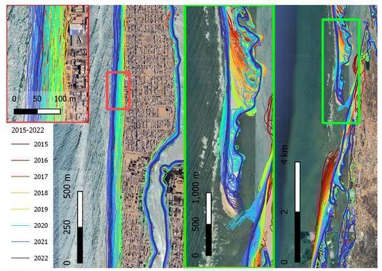
Figure 6.
Large spatiotemporal application at Saint Louis (Senegal), over the period from 2015 to 2022. The background image is of 2023, and it shows that the sand spit has even progressed southward.
The colouring of the lines in Figure 6 refers to a specific date; the colour bar shows only the increase in colour per year. The overall waterline estimate covers a 40 km stretch along the coast from Mauritania to the village of Léona. The left plot zooms in on part of the village of St. Louis, which is located on the sand spit. This area is particularly exposed to waves and infra-gravity energy that both inundate the inhabited area. Following the colour code of the lines, it can be seen that the beach is eroding between 2015 and 2019, while after 2019 this part of the beach shows significant accretion. The exact cause is currently being investigated by the World Bank’s WACA programme and is not part of this study. The two plots to the right of Figure 6 show the tip of the spit south of the city of St. Louis. Between August 2015 and the end of December 2022, the sand spit migrated 3700 m southwards, an average of 530 m per year. The average interval between waterline detection dates was 5 to 10 days, depending on the season, which was mostly influenced by clouds and dense Sahara dust. The Lange de Barbarie is supplied with sediments from the Senegal river. The rain-season transports a significant amount of suspended sediment to the inlet. Hence, large sediment plumes can be observed, as in Figure A2. The same Figure shows that, despite this large quantity of sediments in the water, Shoreliner is capable of properly deriving a waterline.
4.2. Transferability to Other Satellite Sensors
To upscale to large spatio-temporal scales while maintaining sufficient local resolution, Sentinel-2 alone is not sufficient. Although the Sentinel-2 dataset is growing and the Copernicus programme is being maintained with Sentinel-2C and D, and has even been extended with Sentinel-2NG (Next Generation), the time series is not long enough to see the effects of coastal evolution on long time scales. The SCoWI relies on the visible, NIR and SWIR spectral bands; as long as these spectral bands are maintained in future satellite series, waterline detection should work. The USGS Landsat series has a long record of over 40 years of Earth observation satellite data. Although the ground resolution and revisit interval are slightly inferior to Sentinel-2, it does provide the ability to look further back in time.
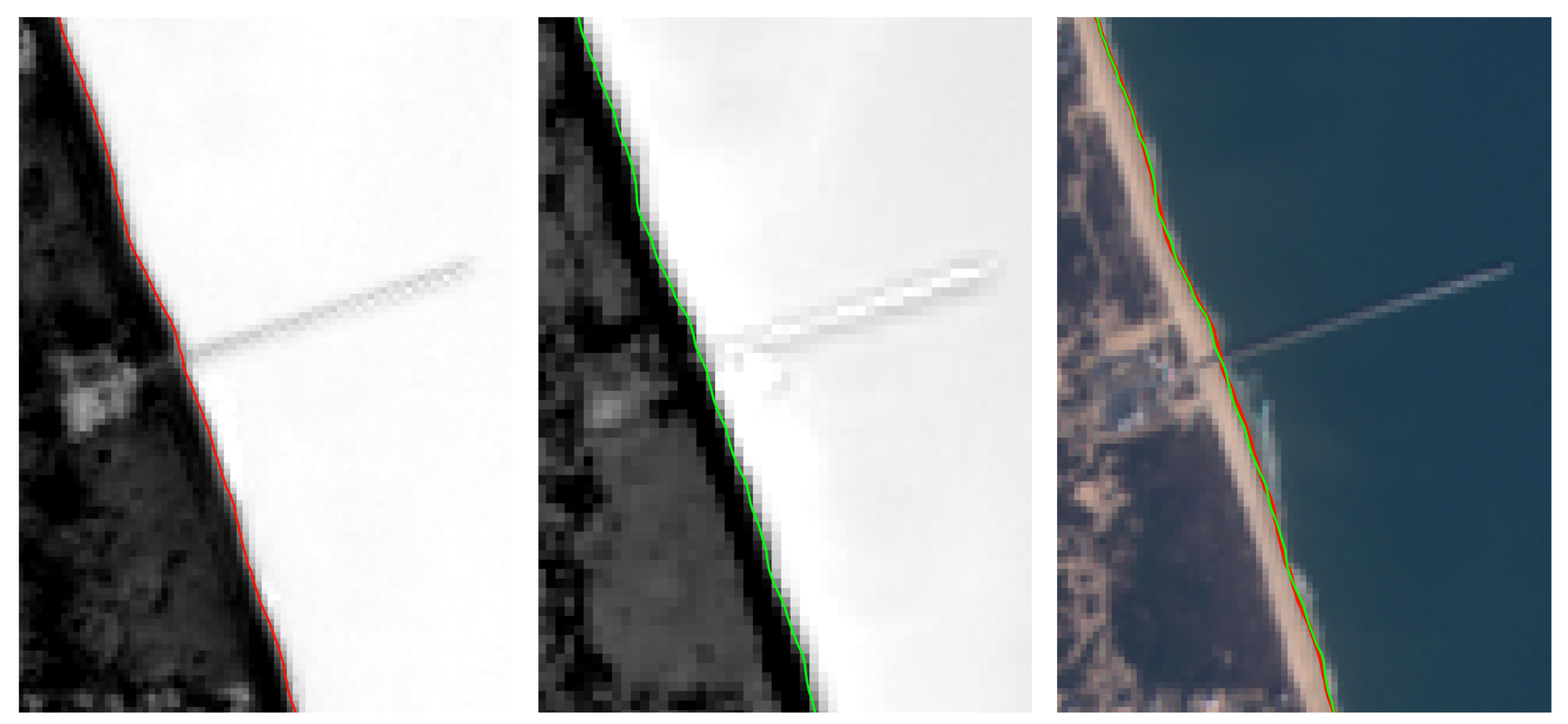
The Landsat spectral bands are similar to those of Sentinel-2, but not identical. There are considerable efforts to harmonise the Sentinel and Landsat acquisitions, but this is one of the reasons why, for example, the CoastSat module has to be retrained for each satellite and sensor type. Let us try to blindly apply the SCoWI index optimised for Sentinel-2 to some Landsat optical imagery acquired around the FRF at Duck, USA. Like most optical Earth observation satellites, both Sentinel-2 and Landsat are sun-synchronised satellites, typically passing between 10:30 and 11:30 local time. There are dates when both Sentinel-2 and Landsat pass on the same day, sometimes within a few minutes of each other. The images in Figure 7 are an illustration of one such date, 21 February 2023, which allows us to explore the transferability of the method.

Figure 7.
SCoWI applied to Sentinel-2 and LandSat satellite optical imagery at Duck (USA). The left-hand image shows the SCoWI applied to a Sentinel-2 image (21 February 2023 at 15h50 GMT) and the middle image to Landsat-8 image (21 February 2023 at 15h41 GMT). The greyscale limits are set between 2% and 98% of all pixel values for both images. The coloured lines represent the detected instantaneous waterline, which are then both superimposed onto a Sentinel-2 colour image on the right-hand side.
The left image in Figure 7 illustrates the effective separation of land and sea using the SCoWI formulation. Water pixels tend to be bright, while land pixels tend to be dark. The same applies to the Landsat imagery. In particular, given the difference in spatial resolution, one might expect a large difference between the derived instantaneous water lines, but the difference in resolution appears to be well counteracted by the procedures used to spatially extract the water line. The bias between the two lines shown in the right-hand plot of Figure 7 is 0.08 m and the RMS difference is 2.21 m, well within the expected and observed precision of the method itself. This can be attributed to the relatively calm wave conditions on 21 February 2023: Hs = 0.55 m, Tp = 9.1 s and Tm = 4.5 s (data from the Wave Rider buoy in 17 m water depth at the FRF). The wave effects, such as setup or a strong infragravity component, can be considered limited in this case.
4.3. Limitations
The SCoWI has been tested at a variety of sites, including very steep beaches, dissipative beaches and beaches with black volcanic sand (Figures are shown in Appendix A). The shorelines were obtained to be qualitatively matched. However, there are limitations to this method, and perhaps to spaceborne waterline detection in general. As SCoWI relies purely on radiometry, areas where little or no photons are reflected back to the satellite sensor will have a negative impact on visibility and hence on shoreline detection. Think of shaded areas such as rocky beaches. Given the sun-synchronous nature of most optical Earth observation satellites, these shaded areas will have significantly less useful data due to the sun’s angle of incidence around the satellite’s pass time. Also, morphological features around the waterline and/or shallow water features such as atolls, tidal flats, including mudflats, and a high proportion of black (usually volcanic) land pixels remain a challenge.
Slightly different, but related to radiometry, is not the lack of reflectance, but the dependence of SCoWI on infrared band information. Water and land are relatively easy to distinguish using the Near InfraRed (NIR) bands, and even more so using the Short Wave InfraRed (SWIR) bands. These bands are often missing from Very High Resolution (VHR) optical satellites. NIR at high resolution is achievable (Pleiades and Worldview), but SWIR at high resolution is much more complex due to physical limitations, not to mention smaller satellites, which often have a different type of sensor on board—a matrix sensor instead of line sensors combined with the push-broom concept.
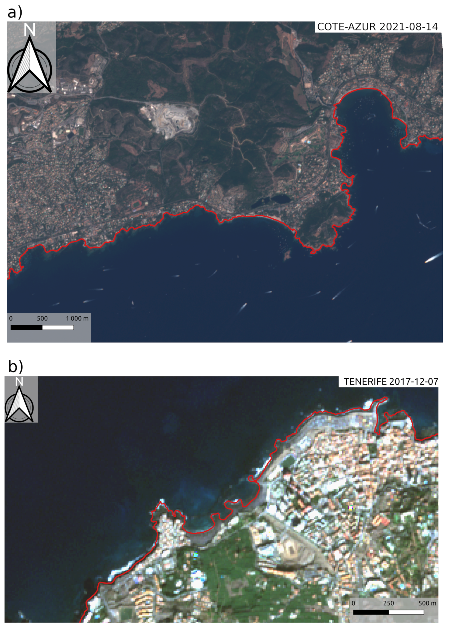
This new formulation has been visually verified at a dozen sites around the world, but only one site has been used to validate absolute performance—at which it was not developed. While single-site validation is not uncommon in the early stages of development [12,28], we are aware of recent efforts to standardise validation across documented sites. However, it is notable that these sites are slightly biased towards higher latitudes and seasonally (storm) driven factors. Here we show that the extension to Landsat is possible using ScoWI, and further development is planned to extend the CNES HPC pipeline, Shoreliner, with Landsat-based SCoWI calculations. Once Landsat-SCoWI is in place, the standardised shoreline verification sites will be used to analyse and compare performance in more detail.
5. Conclusions
This paper demonstrates the potential of the purpose-built SCoWI, an index optimised for land-water classification in coastal zones, combined with a refined thresholding algorithm based on Otsu’s threshold to extract accurate satellite-derived instantaneous water lines. Based entirely on measured physical reflectance, the method is independent of ancillary and external data, stable over a wide range of coastal environments and requires no training. A sub-pixel accuracy of 8.3 m RMSE is found at the validation site in Duck, NC, on the US east coast, placing it among the most advanced SDS methods. However, difficulties are observed for shaded areas where photon reflection is minimal, particularly for cliff areas with the beach on the west side due to the 10:30 local time pass of the Sentinel-2 satellite and also Landsat. The method is implemented in a Python API called Shoreliner on the CNES high performance cluster. Its large-scale application shows great efficiency in estimating the instantaneous waterline over 8 years in a few minutes when the data are available. A significant gain in computational efficiency compared to other state-of-the-art methods makes global applications much more resource efficient (Green IT). Preliminary studies demonstrate the transferability of the method, initially developed for Sentinel-2 Level1C imagery, to Landsat optical imagery, allowing rapid and stable monitoring of coastal sites from the 1980s to the present. Future work includes integrating Landsat optical image analysis into Shoreliner, harnessing the power of over 40 years of time series data at large spatial scales on the HPC, and exploring transferability to other matrix sensors or very high resolution satellites that rarely measure reflectance in the shortwave infrared band.
Author Contributions
Conceptualisation: E.W.J.B., A.N.K. and S.A.; methodology: A.N.K., E.W.J.B. and S.A.; software: A.N.K., S.A. and E.W.J.B.; validation, E.W.J.B., A.N.K., S.A., R.A. and A.P.; formal analysis: A.N.K., E.W.J.B. and S.A.; investigation: A.N.K., S.A., M.G., A.P. and E.W.J.B.; resources: E.W.J.B., J.-M.D. and S.A.; data curation: A.N.K., E.W.J.B., M.G. and A.P.; writing—original draft preparation: A.N.K., E.W.J.B., S.A. and M.G.; writing—review and editing: all authors; visualisation: A.N.K. and E.W.J.B.; supervision: S.A.; project administration, E.W.J.B. and S.A.; funding acquisition: E.W.J.B., J.-M.D. and S.A. All authors have read and agreed to the published version of the manuscript.
Funding
This work was fully funded by the French Space Agency (CNES).
Acknowledgments
We would like to thank the US army corps of Engineers, ERDC, at the FRF for all the effort in maintaining an incredible dataset of field measurements and making these data openly accessible.
Conflicts of Interest
The authors declare no conflicts of interest.
Abbreviations
The following abbreviations are used in this manuscript:
| API | Application Programming Interface |
| AVISO | Archiving, Validation and Interpretation of Satellite Oceanographic Data |
| AWEI | Automated Water Extraction Index |
| CASSIE | Coastal Analyst System from Space Imagery Engine |
| CNES | Centre National d’Etudes Spatiales |
| ECFAS | European Coastal Flood Awareness System |
| ERDC | Engineer Research and Development Center |
| FES | Finite Element Solution |
| FRF | Field Research Facility |
| GPS | Global Positioning System |
| HPC | High Performance Cluster |
| IRD | Institut de Recherche pour le developpement |
| LEGOS | Laboratoire d’Etudes en Geophysique et Oceanographie Spatiales |
| NDWI | Normalised Difference Water Index |
| MNDWI | Mean Normalised Difference Water Index |
| MDPI | Multidisciplinary Digital Publishing Institute |
| NIR | Near Infrared |
| NOAA | National Oceanic and Atmospheric Administration |
| PEPS | Plateforme d’Exploitation des Produits Sentinel |
| RGB | Red–Green–Blue |
| RMS | Root Mean Square |
| SCoWI | Subtractive Coastal Water Index |
| SDS | Satellite-Derived Shoreline |
| SWIR | Short Wave InfraRed |
Appendix A
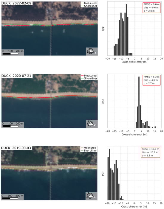
Figure A1.
The validation process of Shoreliner covers a 3-year period, from August 2019 until August 2022, at DUCK, USA. Among the six Sentinel-2 acquisitions that occurred on the same day as an in situ topo-bathymetric survey at Duck, a sub-pixel RMSE (less than 10 m) is found on five dates. The three best results are shown in Figure 4; here we display the three remaining dates.
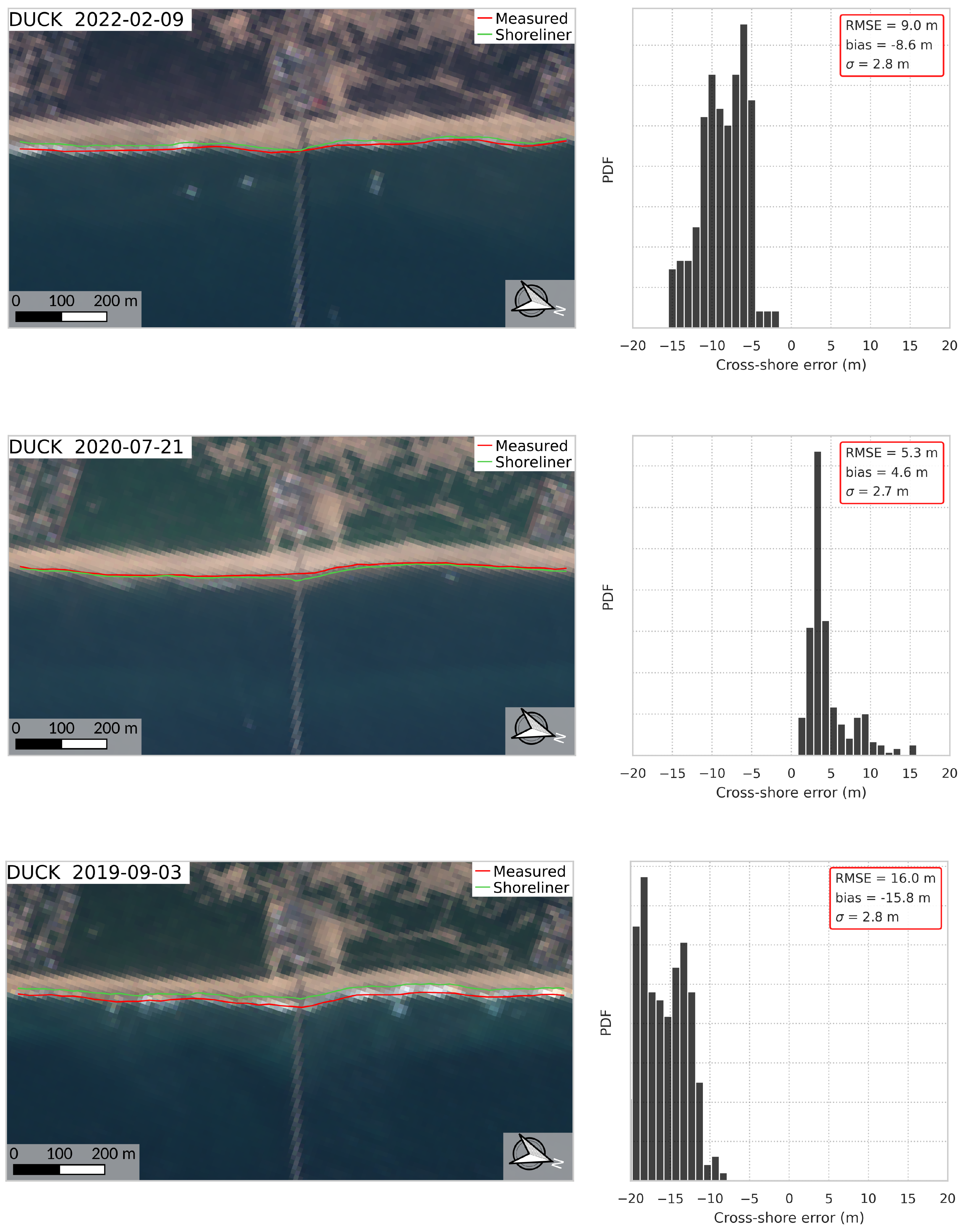

Figure A2.
Example of the shoreline extraction in non-turbid (left) and turbid (right) conditions.
Figure A2.
Example of the shoreline extraction in non-turbid (left) and turbid (right) conditions.
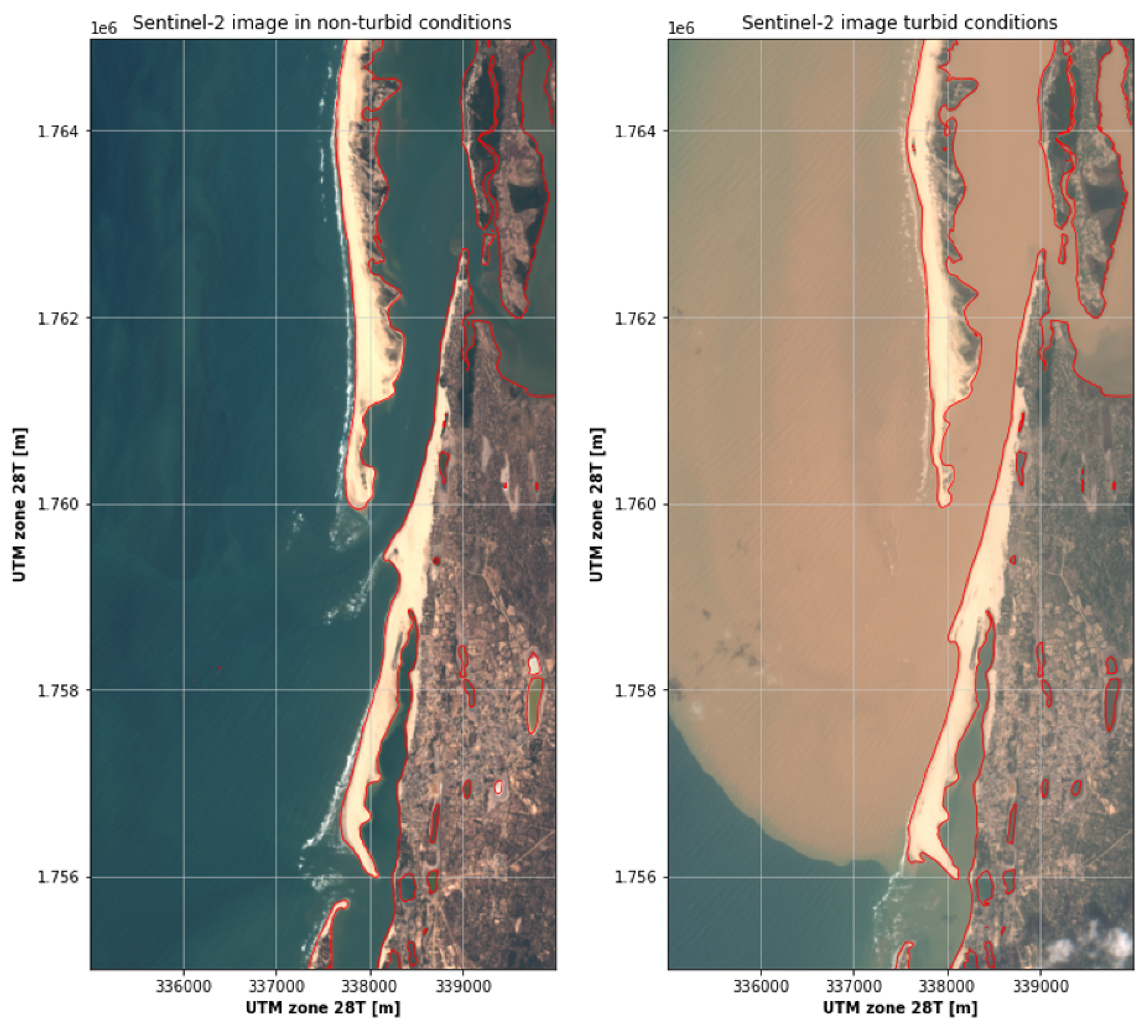

Figure A3.
Visual examples of instantaneous waterlines extracted using Shoreliner. (a) Waterline extracted in the cliffed Mediterranean environment of Saint-Aygulf, France. (b) Waterline extracted on a black sand beach in Tenerife island.
Figure A3.
Visual examples of instantaneous waterlines extracted using Shoreliner. (a) Waterline extracted in the cliffed Mediterranean environment of Saint-Aygulf, France. (b) Waterline extracted on a black sand beach in Tenerife island.
References
- Mohamed Rashidi, A.H.; Jamal, M.H.; Hassan, M.Z.; Mohd Sendek, S.S.; Mohd Sopie, S.L.; Abd Hamid, M.R. Coastal Structures as Beach Erosion Control and Sea Level Rise Adaptation in Malaysia: A Review. Water 2021, 13, 1741. [Google Scholar] [CrossRef]
- Vitousek, S.; Barnard, P.L.; Limber, P. Can beaches survive climate change? J. Geophys. Res. Earth Surf. 2017, 122, 1060–1067. [Google Scholar] [CrossRef]
- Vitousek, S.; Vos, K.; Splinter, K.D.; Erikson, L.; Barnard, P.L. A Model Integrating Satellite-Derived Shoreline Observations for Predicting Fine-Scale Shoreline Response to Waves and Sea-Level Rise Across Large Coastal Regions. J. Geophys. Res. Earth Surf. 2023, 128, e2022JF006936. [Google Scholar] [CrossRef]
- Bergsma, E.W.J.; Almar, R.; Anthony, E.J.; Garlan, T.; Kestenare, E. Wave variability along the world’s continental shelves and coasts: Monitoring opportunities from satellite Earth observation. Adv. Space Res. 2022, 69, 3236–3244. [Google Scholar] [CrossRef]
- Apostolopoulos, D.; Nikolakopoulos, K. A review and meta-analysis of remote sensing data, GIS methods, materials and indices used for monitoring the coastline evolution over the last twenty years. Eur. J. Remote Sens. 2021, 54, 240–265. [Google Scholar] [CrossRef]
- Bishop-Taylor, R.; Nanson, R.; Sagar, S.; Lymburner, L. Mapping Australia’s dynamic coastline at mean sea level using three decades of Landsat imagery. Remote Sens. Environ. 2021, 267, 112734. [Google Scholar] [CrossRef]
- Wu, L.; Tajima, Y.; Yamanaka, Y.; Shimozono, T.; Sato, S. Study on characteristics of SAR imagery around the coast for shoreline detection. Coast. Eng. J. 2019, 61, 152–170. [Google Scholar] [CrossRef]
- Tajima, Y.; Wu, L.; Fuse, T.; Shimozono, T.; Sato, S. Study on shoreline monitoring system based on satellite SAR imagery. Coast. Eng. J. 2019, 61, 401–421. [Google Scholar] [CrossRef]
- Yoshimitsu, T.; Lianhui, W.; Kunihiro, W. Development of a Shoreline Detection Method Using an Artificial Neural Network Based on Satellite SAR Imagery. Remote Sens. 2021, 13, 2254. [Google Scholar] [CrossRef]
- Binet, R.; Bergsma, E.W.J.; Poulain, V. ACCURATE SENTINEL-2 INTER-BAND TIME DELAYS. ISPRS Ann. Photogramm. Remote Sens. Spat. Inf. Sci. 2022, V-1-2022, 57–66. [Google Scholar] [CrossRef]
- McAllister, E.; Payo, A.; Novellino, A.; Dolphin, T.; Medina-Lopez, E. Multispectral satellite imagery and machine learning for the extraction of shoreline indicators. Coast. Eng. 2022, 174, 104102. [Google Scholar] [CrossRef]
- Vos, K.; Splinter, K.D.; Harley, M.D.; Simmons, J.A.; Turner, I.L. CoastSat: A Google Earth Engine-enabled Python toolkit to extract shorelines from publicly available satellite imagery. Environ. Model. Softw. 2019, 122, 104528. [Google Scholar] [CrossRef]
- Almeida, L.P.; Efraim de Oliveira, I.; Lyra, R.; Scaranto Dazzi, R.L.; Martins, V.G.; Henrique da Fontoura Klein, A. Coastal Analyst System from Space Imagery Engine (CASSIE): Shoreline management module. Environ. Model. Softw. 2021, 140, 105033. [Google Scholar] [CrossRef]
- Khan, M.J.U.; Ansary, M.N.; Durand, F.; Testut, L.; Ishaque, M.; Calmant, S.; Krien, Y.; Islam, A.S.; Papa, F. High-Resolution Intertidal Topography from Sentinel-2 Multi-Spectral Imagery: Synergy between Remote Sensing and Numerical Modeling. Remote Sens. 2019, 11, 2888. [Google Scholar] [CrossRef]
- Irazoqui Apecechea, M.; Melet, A.; Armaroli, C. Towards a pan-European coastal flood awareness system: Skill of extreme sea-level forecasts from the Copernicus Marine Service. Front. Mar. Sci. 2023, 9, 1091844. [Google Scholar] [CrossRef]
- Pucino, N.; Kennedy, D.M.; Young, M.; Ierodiaconou, D. Assessing the accuracy of Sentinel-2 instantaneous subpixel shorelines using synchronous UAV ground truth surveys. Remote Sens. Environ. 2022, 282, 113293. [Google Scholar] [CrossRef]
- Gao, B. NDWI—A normalized difference water index for remote sensing of vegetation liquid water from space. Remote Sens. Environ. 1996, 58, 257–266. [Google Scholar] [CrossRef]
- McFEETERS, S.K. The use of the Normalized Difference Water Index (NDWI) in the delineation of open water features. Int. J. Remote Sens. 1996, 17, 1425–1432. [Google Scholar] [CrossRef]
- Xu, H. Modification of normalised difference water index (NDWI) to enhance open water features in remotely sensed imagery. Int. J. Remote Sens. 2006, 27, 3025–3033. [Google Scholar] [CrossRef]
- Pekel, J.F.; Vancutsem, C.; Bastin, L.; Clerici, M.; Vanbogaert, E.; Bartholomé, E.; Defourny, P. A near real-time water surface detection method based on HSV transformation of MODIS multi-spectral time series data. Remote Sens. Environ. 2014, 140, 704–716. [Google Scholar] [CrossRef]
- Feyisa, G.L.; Meilby, H.; Fensholt, R.; Proud, S.R. Automated Water Extraction Index: A new technique for surface water mapping using Landsat imagery. Remote Sens. Environ. 2014, 140, 23–35. [Google Scholar] [CrossRef]
- Fisher, A.; Flood, N.; Danaher, T. Comparing Landsat water index methods for automated water classification in eastern Australia. Remote Sens. Environ. 2016, 175, 167–182. [Google Scholar] [CrossRef]
- Bishop-Taylor, R.; Sagar, S.; Lymburner, L.; Alam, I.; Sixsmith, J. Sub-Pixel Waterline Extraction: Characterising Accuracy and Sensitivity to Indices and Spectra. Remote Sens. 2019, 11, 2984. [Google Scholar] [CrossRef]
- Sentinel 2 Mission Requirements Document; European Space Agency: Paris, France, 2010.
- Bergsma, E.W.J.; Almar, R. Coastal coverage of ESA’ Sentinel 2 mission. Adv. Space Res. 2020, 65, 2636–2644. [Google Scholar] [CrossRef]
- Vos, K.; Harley, M.D.; Splinter, K.D.; Simmons, J.A.; Turner, I.L. Sub-annual to multi-decadal shoreline variability from publicly available satellite imagery. Coast. Eng. 2019, 150, 160–174. [Google Scholar] [CrossRef]
- Otsu, N. A Threshold Selection Method from Gray-Level Histograms. IEEE Trans. Syst. Man Cybern. 1979, 9, 62–66. [Google Scholar] [CrossRef]
- Castelle, B.; Masselink, G.; Scott, T.; Stokes, C.; Konstantinou, A.; Marieu, V.; Bujan, S. Satellite-derived shoreline detection at a high-energy meso-macrotidal beach. Geomorphology 2021, 383, 107707. [Google Scholar] [CrossRef]
- Cipolletti, M.P.; Delrieux, C.A.; Perillo, G.M.; Cintia Piccolo, M. Superresolution border segmentation and measurement in remote sensing images. Comput. Geosci. 2012, 40, 87–96. [Google Scholar] [CrossRef]
- Forte, M.F.; Birkemeier, W.A.; Mitchell, J.R. Nearshore Survey System Evaluation; Technical Report; U.S. Army Engineer Research and Development Center ERDC-CHL Vicksburg United States: Vicksburg, MI, USA, 2017. [Google Scholar]
- Park, J.; Heitsenrether, R.; Sweet, W. Water level and wave height estimates at NOAA tide stations from acoustic and microwave sensors. J. Atmos. Ocean. Technol. 2014, 31, 2294–2308. [Google Scholar] [CrossRef]
- Konstantinou, A.; Scott, T.; Masselink, G.; Stokes, K.; Conley, D.; Castelle, B. Satellite-based shoreline detection along high-energy macrotidal coasts and influence of beach state. Mar. Geol. 2023, 462, 107082. [Google Scholar] [CrossRef]
- Vos, K.; Splinter, K.D.; Palomar-Vázquez, J.; Pardo-Pascual, J.E.; Almonacid-Caballer, J.; Cabezas-Rabadán, C.; Kras, E.C.; Luijendijk, A.P.; Calkoen, F.; Almeida, L.P.; et al. Benchmarking satellite-derived shoreline mapping algorithms. Commun. Earth Environ. 2023, 4, 345. [Google Scholar] [CrossRef]
- Graffin, M.; Taherkhani, M.; Leung, M.; Vitousek, S.; Kaminsky, G.; Ruggiero, P. Monitoring interdecadal coastal change along dissipative beaches via satellite imagery at regional scale. Camb. Prisms Coast. Futur. 2023, 1, e42. [Google Scholar] [CrossRef]
- Vos, K.; Harley, M.D.; Turner, I.L.; Splinter, K.D. Pacific shoreline erosion and accretion patterns controlled by El Niño/Southern Oscillation. Nat. Geosci. 2023, 16, 140–146. [Google Scholar] [CrossRef]
- Almar, R.; Stieglitz, T.; Addo, K.A.; Ba, K.; Ondoa, G.A.; Bergsma, E.W.J.; Bonou, F.; Dada, O.; Angnuureng, D.; Arino, O. Coastal Zone Changes in West Africa: Challenges and Opportunities for Satellite Earth Observations. Surv. Geophys. 2022, 44, 249–275. [Google Scholar] [CrossRef]
- Bergsma, E.W.J.; Sadio, M.; Sakho, I.; Almar, R.; Garlan, T.; Gosselin, M.; Gauduin, H. Sand-spit Evolution and Inlet Dynamics derived from Space-borne Optical Imagery: Is the Senegal-river Inlet Closing? J. Coast. Res. 2020, 95, 372–376. [Google Scholar] [CrossRef]
- Taveneau, A.; Almar, R.; Bergsma, E.W.J.; Sy, B.A.; Ndour, A.; Sadio, M.; Garlan, T. bserving and Predicting Coastal Erosion at the Langue de Barbarie Sand Spit around Saint Louis (Senegal, West Africa) through Satellite-Derived Digital Elevation Model and Shoreline. Remote Sens. 2021, 13, 2454. [Google Scholar] [CrossRef]
- Daly, C.; Baba, W.; Bergsma, E.W.J.; Thoumyre, G.; Almar, R.; Garlan, T. The new era of regional coastal bathymetry from space: A showcase for West Africa using optical Sentinel-2 imagery. Remote Sens. Environ. 2022, 278, 113084. [Google Scholar] [CrossRef]
- Lyard, F.H.; Allain, D.J.; Cancet, M.; Carrère, L.; Picot, N. FES2014 global ocean tide atlas: Design and performance. Ocean Sci. 2021, 17, 615–649. [Google Scholar] [CrossRef]


Disclaimer/Publisher’s Note: The statements, opinions and data contained in all publications are solely those of the individual author(s) and contributor(s) and not of MDPI and/or the editor(s). MDPI and/or the editor(s) disclaim responsibility for any injury to people or property resulting from any ideas, methods, instructions or products referred to in the content. |
© 2024 by the authors. Licensee MDPI, Basel, Switzerland. This article is an open access article distributed under the terms and conditions of the Creative Commons Attribution (CC BY) license (https://creativecommons.org/licenses/by/4.0/).