Article

BCNet: Boundary-Constrained Remote Sensing Change Detection Network Based on Vision Foundation Models

School of Physics and Electronic Science, Changsha University of Science and Technology, Changsha 410114, China
*
Author to whom correspondence should be addressed.
Remote Sens. 2026, 18(16), 2760; https://doi.org/10.3390/rs18162760
Submission received: 3 June 2026 / Revised: 30 July 2026 / Accepted: 13 August 2026 / Published: 15 August 2026
(This article belongs to the Section Remote Sensing Image Processing)

Highlights

What are the main findings?
  • A boundary-constrained change detection network (BCNet) is proposed to effectively transfer visual foundation models to remote sensing change detection.
  • The differential detail enhancement module, multi-scale edge enhancement module, and edge feature constraint strategy significantly improve change discrimination and boundary localization.
  • BCNet achieves state-of-the-art performance on four public benchmarks, including LEVIR-CD, WHU-CD, NJDS, and MSRS-CD.
What are the implications of the main findings?
  • This study confirms that visual foundation models can be efficiently transferred to change detection tasks while maintaining a good balance between model accuracy and computational cost.
  • The proposed method provides a viable technical solution for large-scale remote sensing applications such as land-use management, urban planning, and environmental change assessment.

Abstract

Limited by the diversity and complexity of real-world scenes, existing remote sensing change detection methods often suffer from insufficient fine-grained semantic understanding and blurred boundaries of change targets. To address these issues, this paper proposes a boundary-constrained remote sensing change detection network based on vision foundation models (BCNet). BCNet employs a differential modeling approach and multi-branch guidance mechanism to design a differential detail enhancement module, amplifying fine-grained semantic information. Through cross-layer feature alignment, stepwise fusion, and edge-sensitive modeling, it constructs a multi-scale edge enhancement module that enhances perception of minute variations and edge details, fully leveraging the universal semantic representation capabilities of the vision foundation model. In addition, an edge feature constraint mechanism is introduced that applies dual guidance and supervision during the feature fusion and output stages. This mechanism achieves refined delineation of change region boundaries and significantly mitigates the issue of boundary blurring. Experimental results on four mainstream datasets, namely LEVIR-CD, WHU-CD, NJDS and MSRS-CD, demonstrate that BCNet outperforms 13 state-of-the-art methods in terms of key metrics including F1 and IoU. Against the best VFM-based baseline, BCNet obtains F1 score gains of 0.21%, 0.71%, 6.33% and 0.63% on the above four datasets. Specifically, the proposed method exhibits superior detection accuracy and edge detail preservation capabilities in complex regions.

1. Introduction

Remote sensing change detection (RSCD) focuses on identifying and pinpointing variations in land cover and anthropogenic activities by comparing multi-temporal remote sensing images covering identical geographic regions [1]. As a fundamental technology for Earth observation and environmental monitoring, RSCD occupies a vital position in numerous real-world applications. Typical scenarios include urban sprawl monitoring, analysis of land use and land cover transitions, disaster evaluation, and ecological environment conservation, as well as land resource administration [2,3].
With the continuous improvement of the spatial resolution of remote sensing imagery, ground objects exhibit increasingly rich texture and geometric characteristics. Particularly in scenarios such as densely built urban areas, interlaced farmland regions, and complex natural landscapes, change targets often present multi-scale variations, irregular shapes, and subtle semantic differences. Accurately extracting change information under complex background interference while preserving the geometric integrity of change boundaries has become a critical issue of common concern in both academic research and engineering applications.
In recent years, deep learning approaches built upon convolutional neural networks (CNNs) and Transformers [4,5] have attained remarkable accuracy improvements for change detection, benefiting from their outstanding feature extraction and context modeling abilities. Nevertheless, current approaches still confront two prominent difficulties when processing high-resolution remote sensing imagery. First, change targets in complex scenes usually exhibit large variations in scale while presenting only subtle semantic differences from the background, making fine-grained change perception particularly challenging. Second, the boundaries of change areas are irregular in shape and are easily affected by background noise and image artifacts, ultimately leading to phenomena such as boundary sticking, blurred contours, and the loss of subtle change features.
The Vision Foundation Models (VFMs) are pre-trained on large-scale generic image datasets and possess rich and highly generalizable visual priors. They can effectively model complex topographic features and high-level semantic information, providing a novel research paradigm for improving the accuracy and robustness of RSCD. A variety of efforts have been made in existing research to realize effective knowledge transfer from VFMs to RSCD tasks. As an example, Chen et al. [6] put forward the time-traveling pixels approach. By simulating pixel-wise temporal variation trends, this method migrates implicit knowledge learned by the Segment Anything Model (SAM) [7] into bi-temporal change modeling. Dong et al. [8] reconstructed the architecture of CLIP [9], strengthening the model’s capacity to extract change-sensitive features with consistent semantics from bi-temporal remote sensing images. Nevertheless, directly applying VFMs to change detection still suffers from notable limitations. The features generated by these methods tend to focus on high-level semantic consistency while neglecting the fine boundary structures and local details within changed regions. Such a bias toward global semantics and insensitivity to spatial details renders existing VFM-based methods unable to meet the demands of high-precision change detection, especially for fine-grained discrimination in complex boundary areas.
To address these challenges, this paper proposes a boundary-constrained remote sensing change detection network based on VFM (BCNet). BCNet adopts a VFM as the backbone feature extractor to fully exploit deep semantic information from bi-temporal images. On this basis, a difference-detail enhancement module is designed to strengthen discriminative features between changed and unchanged regions. In addition, a multi-scale edge enhancement module is introduced to finely model change information across multi-temporal features, significantly improving the model’s sensitivity to subtle changes and complex boundary details. Furthermore, a edge feature constraint mechanism is investigated, which provides dual guidance to change regions at both the feature fusion stage and the output prediction stage. By reinforcing edge feature constraints in both the feature space and the prediction space, this mechanism effectively alleviates boundary ambiguity in change detection. Extensive experiments were conducted using four publicly available remote sensing image change detection benchmark datasets and 13 state-of-the-art (SOTA) methods to validate BCNet’s capability in preserving details in complex edge regions and its detection robustness. The main contributions of this paper are as follows:
  • A boundary-constrained change detection network based on vision foundation models, termed BCNet, is proposed. The network effectively exploits the semantic representation potential of VFM, addressing the limited generalization ability and insufficient semantic understanding of traditional models in complex scenes and providing a new technical paradigm for RSCD.
  • A difference-detail enhancement module and a multi-scale edge enhancement module are designed, which improve the discriminability of change features and enhance the model’s ability to resolve boundary details.
  • An edge feature constraint mechanism is introduced to strengthen boundary guidance at both the feature fusion and output prediction levels, markedly improving the localization accuracy and boundary integrity of change regions.
  • Extensive experimental results on four mainstream datasets comprehensively validate the superiority and robustness of the proposed method in complex scenarios.
The rest of this paper is organized as follows. Section 2 briefly reviews deep learning-based RSCD methods and VFM-based RSCD-related research. Section 3 elaborates on the overall architecture and core designs of the proposed BCNet method. Section 4 introduces the experimental configurations, evaluates the model performance, and conducts in-depth result analysis. Finally, Section 5 summarizes the full work and draws the corresponding conclusions.

2. Related Work

2.1. Deep Learning-Based RSCD

With the booming advancement of deep learning techniques, deep learning-based RSCD approaches have gradually become the dominant research direction in remote sensing change detection. Traditional research primarily adopts CNNs combined with siamese network structures to autonomously extract differential features from multi-temporal remote sensing pairs. In representative work, Daudt et al. [10] designed three fully convolutional siamese models, including FC-EF, FC-Siam-conc and FC-Siam-diff. This pioneering study initially integrated CNN frameworks into RSCD research and laid a solid technical foundation for subsequent related explorations. To further strengthen the modeling ability for change targets with diverse scales, scholars have extensively introduced encoder-decoder architectures and multi-scale feature fusion schemes. Through skip connection mechanisms and feature pyramid structures, these methods can effectively fuse low-level spatial details and high-level semantic features. Peng et al. [11] optimized the classic U-Net structure and achieved excellent detection performance, especially for building change identification scenarios. Fang et al. [12] constructed a network with dense skip connections to facilitate adequate fusion of multi-layer feature information, which significantly improves the feature representation capability of change regions. However, limited by the intrinsic local receptive field property of convolutional operations, these CNN-based methods fail to effectively capture long-range dependency relationships and global contextual features in complex remote sensing scenarios, which restricts their overall detection performance.
In recent years, Transformer architectures have been increasingly applied to RSCD tasks, benefiting from the superior self-attention mechanism that enables robust modeling of long-range global contextual dependencies. Zhang et al. [13] constructed a pure Transformer-based siamese U-shaped structure, which effectively captures global spatiotemporal correlations between paired bi-temporal remote sensing images. Bandara et al. [14] adopted a hierarchical Transformer paradigm to extract multi-level coarse semantic cues and fine structural details simultaneously, realizing in-depth fusion of multi-scale differential feature representations. To combine the respective strengths of different architectures, hybrid models that integrate CNNs and Transformers have been widely explored. Such designs leverage CNNs’ superiority in capturing local texture details and Transformers’ unique advantages in modeling global context, substantially improving the overall detection accuracy. For example, Chen et al. [15] proposed the Bitemporal Image Transformer (BiT) framework. This model first adopts ResNet for preliminary feature extraction and subsequently exploits a Transformer encoder to mine comprehensive spatiotemporal contextual information from dual-temporal images. On this basis, Jiang et al. [16] further introduced graph neural networks to strengthen the structural modeling capability of diverse change patterns in complex scenarios.
Overall, although the aforementioned methods have achieved notable improvements in detection accuracy, there remains considerable room for further enhancement in perceiving fine-grained changes and in the precise delineation of change boundaries, especially in complex scenarios.

2.2. VFMs-Based RSCD

VFMs refer to general-purpose visual representation models pre-trained on large-scale generic image or multimodal datasets using self-supervised, weakly supervised, or contrastive learning paradigms. Representative models include SAM [7], CLIP [9], FastSAM [17], and SAM2 [18]. Benefiting from data-driven large-scale pre-training, VFMs are capable of learning visual representations with strong generalization ability and cross-task transfer potential.
Benefiting from the remarkable performance of VFMs in the field of computer vision in recent years [19,20], scholars have gradually applied these pre-trained models to RSCD tasks. This research direction effectively mitigates core bottlenecks in RSCD research, including insufficient labeled remote sensing samples and the complex spatial and spectral characteristics of remote sensing scenes. To enhance the adaptability of VFMs for remote sensing data, Li et al. [21] developed a bridging module structure to narrow the feature distribution discrepancy between natural images and remote sensing imagery, which greatly optimizes the practical performance of VFMs in RSCD scenarios. Focusing on the powerful segmentation capability of the SAM, Ding et al. [22] put forward a novel SAM-based change detection framework named SAM-CD. This method adopts the visual encoder of FastSAM and integrates lightweight convolution adapter modules to specifically capture and aggregate change difference features, realizing targeted feature enhancement for change detection tasks. In another study, Zhang et al. [23] performed fine-tuning optimization on the original SAM model and innovatively introduced a boundary perception loss function. This improvement significantly boosts the model’s ability to capture detailed edge information and enhances the task adaptation performance of SAM in remote sensing change detection. Furthermore, Dong et al. [8] reconstructed the classic CLIP network architecture and proposed an innovative ChangeCLIP model. Relying on the contrastive learning strategy, this model reinforces the semantic feature representation of change regions in bi-temporal remote sensing images, thus achieving more accurate and robust remote sensing change detection results. Recently, many researchers have also applied SAM2 to RSCD. Qin et al. [24] designed SAM2-CD by leveraging SAM2’s multiscale pyramid encoder and an optimized multiscale feature fusion module. Mo et al. [25] proposed a multi-stage dual-encoder-single-decoder (SAM2-MDESD) CD method based on the novel SAM2. Despite the successful application of VFMs to RSCD, several critical challenges remain in practical scenarios. On the one hand, high-level features output by VFMs tend to emphasize semantic consistency and global structural modeling while exhibiting limited capability in representing local details. On the other hand, directly transferring generic VFMs often overlooks the stringent requirements of change detection for spatial localization accuracy and boundary geometric integrity, which easily leads to blurred boundaries, loss of details, or over-smoothing in detection results.
To tackle the above challenges, this work develops a novel network termed BCNet. On the basis of fully leveraging the robust semantic modeling capacity of VFMs, the presented framework considerably improves boundary positioning precision and fine-grained feature characterization of changed areas. This goal is achieved via the elaborately designed difference-detail enhancement module, multi-scale edge modeling scheme, as well as an edge feature constraint strategy. The proposed method offers a viable approach to accomplish high-precision change detection for remote sensing imagery under complicated scenarios.

3. Methods

3.1. Overall Framework

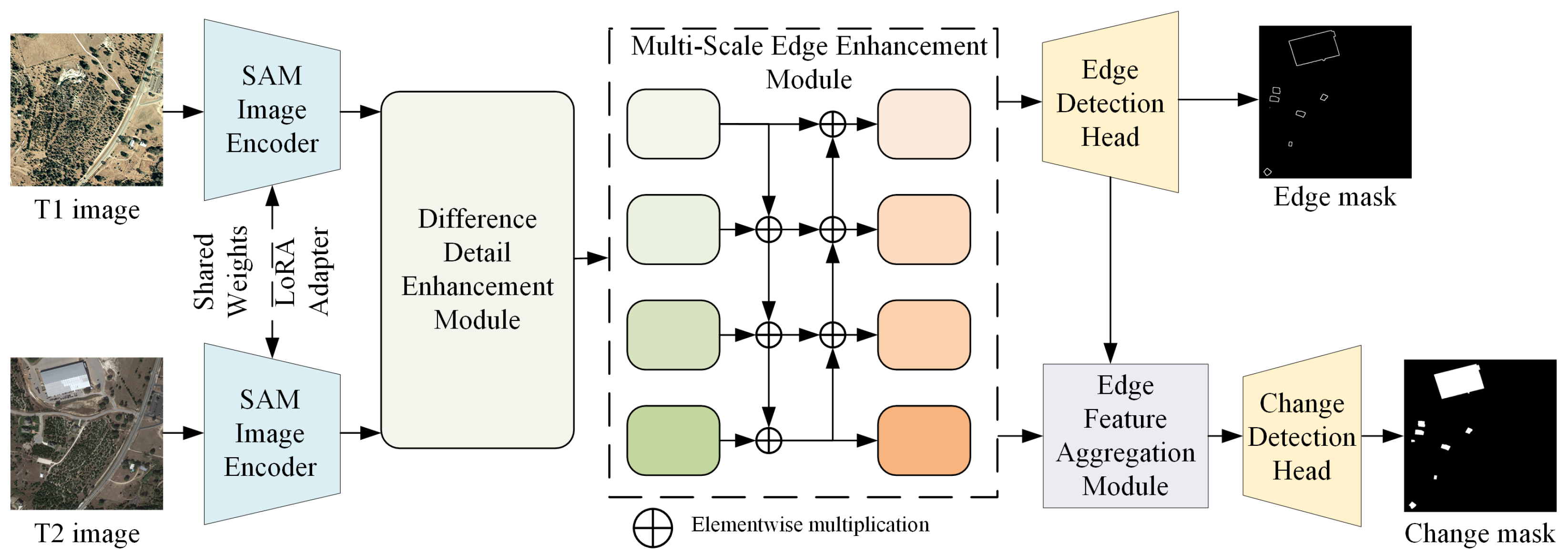
The overall architecture of BCNet is illustrated in Figure 1. The network takes bi-temporal remote sensing images as input and employs a Siamese VFM to extract high-level semantic features [10]. On this basis, different detail enhancement, multi-scale edge enhancement, and edge feature constraint mechanisms are introduced to achieve precise localization and accurate boundary delineation of change regions. Specifically, BCNet adopts a weight-sharing SAM encoder [7] to extract features from the bi-temporal images. To improve the adaptability of the SAM encoder to remote sensing imagery, a LoRA adapter [26] is incorporated for parameter-efficient fine-tuning. This strategy preserves the original semantic representation capability of SAM while reducing training costs and enhancing task relevance for change detection. To further emphasize change information between the bi-temporal images, a Difference-Detail Enhancement Module (DDEM) is designed after the feature extraction stage to receive multi-level features from both temporal inputs. Through different modeling and attention mechanisms, DDEM effectively suppresses redundant background responses in temporally consistent regions, thereby strengthening the discriminative feature representations of change regions. Subsequently, the generated difference features are fed into the Multi-Scale Edge Enhancement Module. By leveraging cross-scale feature interactions and progressive aggregation mechanisms, this module fuses high-level semantic information while preserving the spatial structures and edge details contained in low-level features, resulting in multi-scale feature representations that are more sensitive to change boundaries. This process significantly enhances the model’s ability to perceive subtle change targets and complex, irregular boundaries, providing a reliable feature basis for subsequent boundary-constrained prediction. At the prediction stage, to achieve collaborative optimization of change region detection and edge feature constraints, BCNet adopts a dual-branch prediction strategy. On the one hand, an edge detection head is employed to supervise the learning of multi-scale edge features and explicitly predict boundary information of change regions, generating an edge mask. On the other hand, an edge feature aggregation module is introduced to reversely inject the predicted boundary information into the change features, where it is deeply fused with semantic change features to further strengthen spatial constraint relationships within change regions. Finally, a change detection head outputs pixel-level change detection results, ensuring that the predicted change maps not only possess accurate semantic discrimination but also exhibit clear and complete geometric boundaries.

3.2. Difference-Detail Enhancement Module

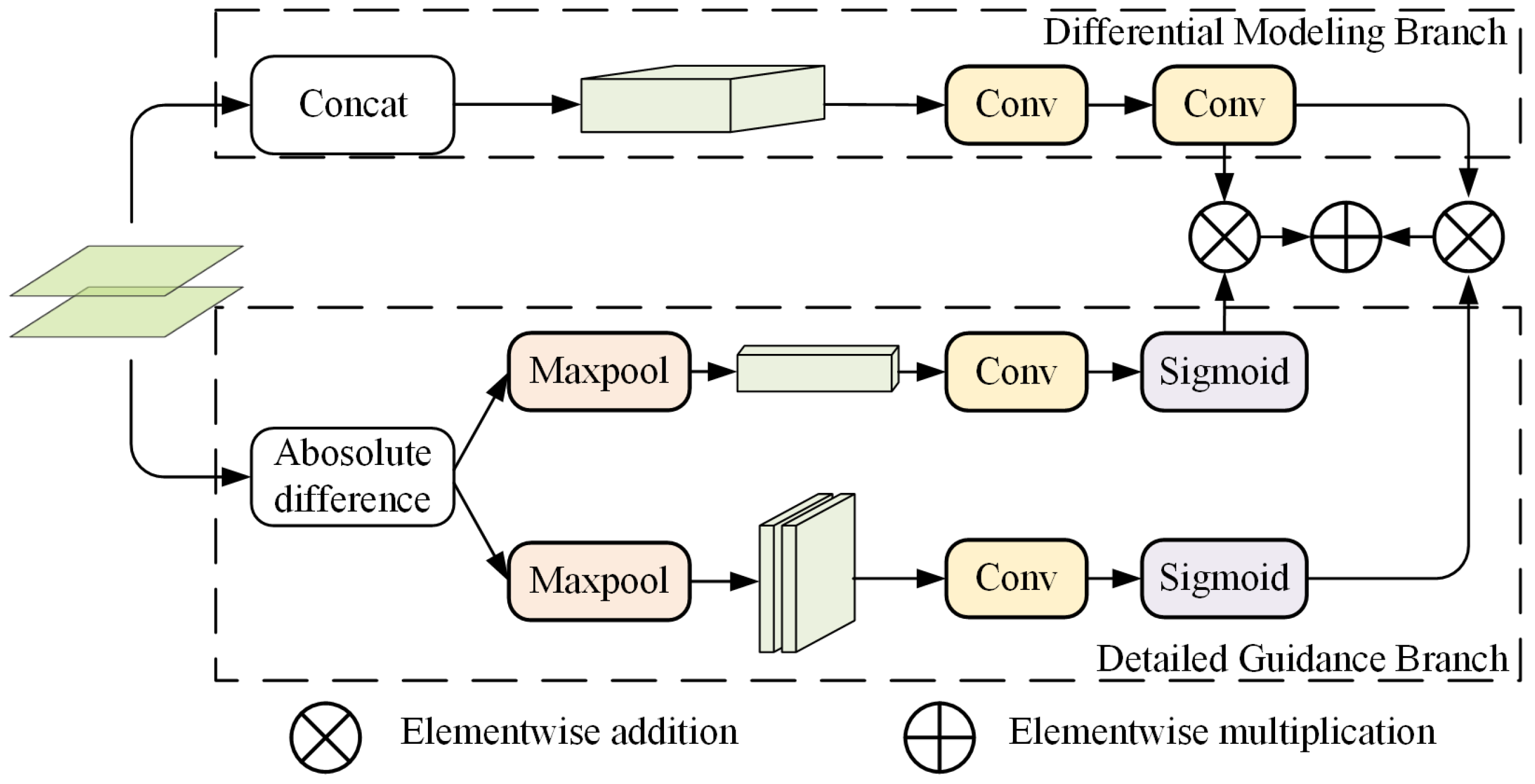
As a VFM designed for generic image segmentation tasks, SAM natively supports only single-image inputs, making it difficult to directly accommodate the bi-temporal feature modeling required for RSCD. To effectively leverage the semantic differences between dual-phase images and enhance the ability to distinguish regions of change, DDEM employs a difference modeling and multi-branch guidance mechanism to directly embed temporal difference modeling into SAM’s self-attention layers, rather than performing post-processing feature subtraction, thereby providing targeted enhancement for regions sensitive to change.
As illustrated in Figure 2, the overall structure of the DDEM consists of two parallel branches: the detail guidance branch and the difference modeling branch. In the detail guidance branch, the bi-temporal feature maps F i = 1 , 2 R H × W × C are concatenated along the channel dimension to obtain a fused feature map C R H × W × 2 C , which maximally preserves fine-grained details from both temporal images.
C = Concat ( F 1 , F 2 )
Subsequently, the concatenated features are enhanced and compressed through two convolutional layers: the first layer strengthens feature representation, while the second reduces the channel dimension back to C, yielding the refined detail-guided feature map C R H × W × C .
In the difference modeling branch, the element-wise absolute difference between the bi-temporal features is first computed to generate the initial difference feature D.
D = | F 1 F 2 |
To capture the distribution characteristics of changes along both the spatial and channel dimensions, D is fed into two parallel sub-paths. Along the channel dimension, global max pooling is applied across the spatial axis to obtain a channel-wise statistic vector F c R 1 × 1 × C . Along the spatial dimension, global max pooling is applied across the channel axis to obtain a spatial response map F s R H × W × 1 .
These two descriptors are then processed by convolutional operations followed by a Sigmoid activation function to generate channel attention weights and spatial attention weights, denoted as F c R 1 × 1 × C and F s R H × W × 1 .
F c = σ ( Conv ( F c ) ) , F s = σ ( Conv ( F s ) )
where σ ( · ) denotes the Sigmoid function that constrains the weights to the range [ 0 , 1 ] .
Finally, the attention weights are applied to the detail-guided feature C , and the enhanced output feature F out is obtained via weighted fusion.
F out = C × F c + C × F s
Through the above design, DDEM achieves enhanced representation of variation regions while preserving original semantic consistency. This improves the model’s ability to capture minute variations in objects and intricate boundary details, providing high-quality variation-aware feature representations for subsequent multi-scale edge enhancement and edge feature constraints. Unlike conventional change enhancement modules that are independently attached after backbone feature extraction, DDEM is embedded into the hierarchical Transformer representations generated by SAM. Since the Transformer encoder already captures long-range contextual dependencies through global self-attention, DDEM focuses on enhancing change-sensitive local responses while preserving globally consistent semantic representations.

3.3. Multi-Scale Edge Enhancement Module

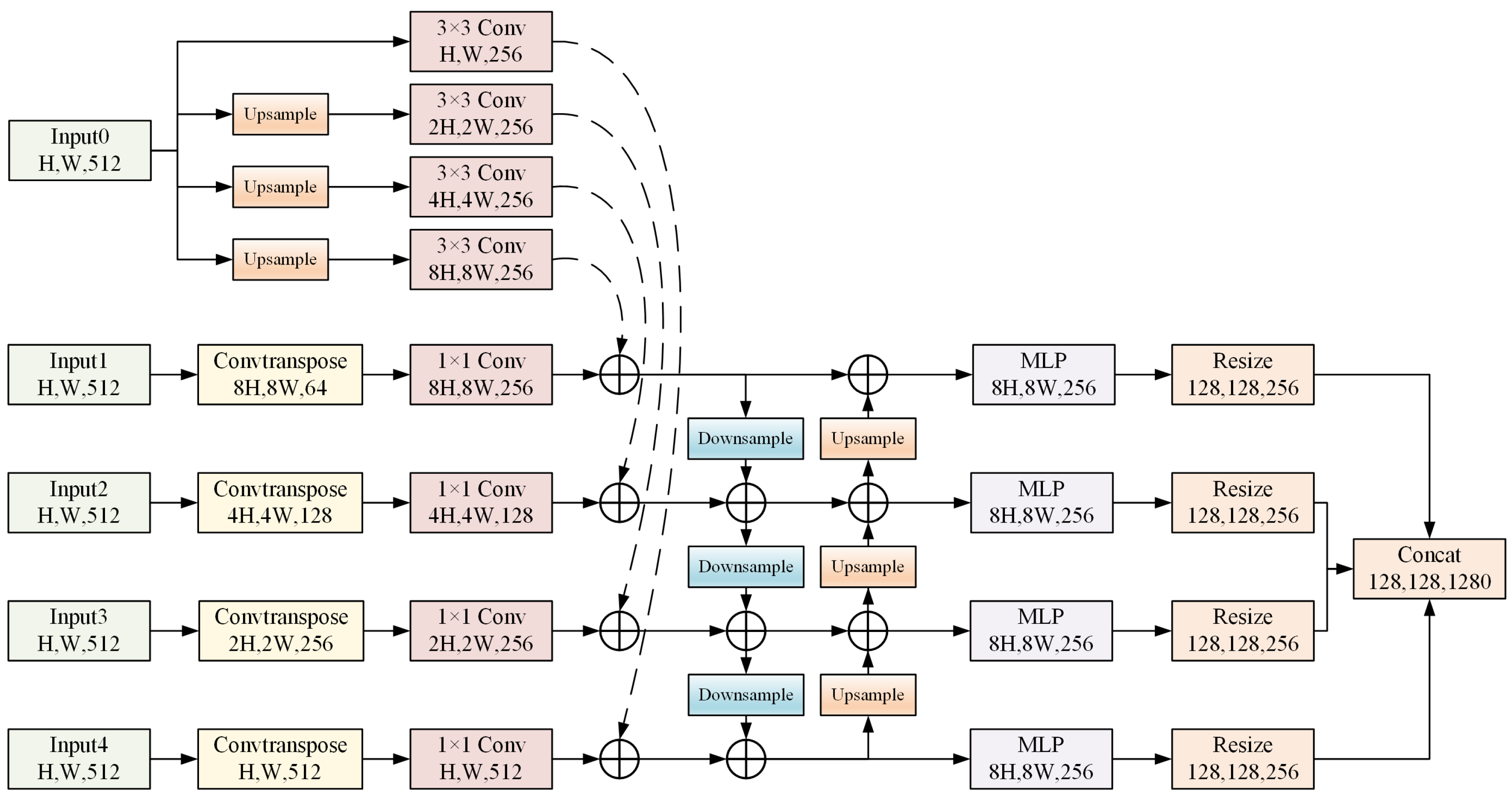
In high-resolution remote sensing image change detection, the boundaries of change regions often exhibit multi-scale and irregular characteristics. To effectively capture these properties and improve boundary detection accuracy, we propose a Multi-Scale Edge Enhancement Module (MEEM), as illustrated in Figure 3. Based on semantic edge features, MEEM establishes a bidirectional interaction channel between shallow foundational priors and deep differential features, thereby eliminating the phenomenon of boundary degradation.
Since shallow features and deep difference features originate from different semantic spaces, directly fusing them usually leads to feature distribution inconsistency. Therefore, MEEM first performs channel alignment and scale normalization before progressive bidirectional interaction, enabling effective integration of structural edge information and high-level semantic change representations. As shown in Figure 3, the inputs to MEEM include the shallow feature F 0 from the first Transformer layer of the SAM encoder and four levels of change features output by DDEM, denoted as { F 1 , F 2 , F 3 , F 4 } . The shallow feature F 0 contains abundant spatial structure and edge detail information, while F 1 F 4 represent progressively higher-level semantic change representations.
Considering that the early layers of the SAM encoder possess strong capability in modeling local structures and contours, MEEM first applies multi-scale convolutional processing to the shallow feature F 0 R H × W × 512 . Specifically, a set of parallel 3 × 3 convolution operations combined with upsampling strategies are employed to transform F 0 into multiple spatial resolutions with a unified channel dimension, producing a set of shallow edge prior features F 0 i ( i = 1 , 2 , 3 , 4 ) . These features provide fine-grained edge feature constraints for subsequent multi-scale fusion.
For the change features F i ( i = 1 , 2 , 3 , 4 ) from DDEM, transposed convolutions are first applied to enhance their scale representation capability. Subsequently, a 1 × 1 convolution is used to compress and align the channel dimensions, yielding feature representations with a unified number of channels.
F i = Conv ( Pose ( F i ) )
Next, the shallow edge prior features are added to the corresponding multi-scale change features to obtain the initial fused features F i . This fusion operation effectively compensates for the lack of spatial geometric details in deep semantic features, enabling the fused representations to simultaneously preserve semantic discriminability and boundary precision.
F i = F i + F 0 i
During the deep feature fusion stage, MEEM adopts a bidirectional interaction strategy that combines top-down and bottom-up pathways. High-level semantic features are propagated to lower levels through resampling to suppress background noise, while low-level detail features are upsampled to supplement high-frequency edge information in higher layers. After each fusion stage, a multilayer perceptron (MLP) is introduced to perform nonlinear mapping and channel re-calibration, further enhancing the boundary response E i .
Finally, the edge-enhanced features at different scales, E i , are uniformly resized to a fixed resolution ( 128 × 128 ) and concatenated along the channel dimension to form the final multi-scale edge feature representation E out .
E out = Concat Re ( E 1 ) , Re ( E 2 ) , Re ( E 3 ) , Re ( E 4 )
This representation jointly integrates fine-grained boundary information from shallow layers and semantic change cues from deep layers, providing high-quality boundary-aware feature support for the subsequent edge detection head and change detection head.

3.4. Edge Feature Aggregation Module

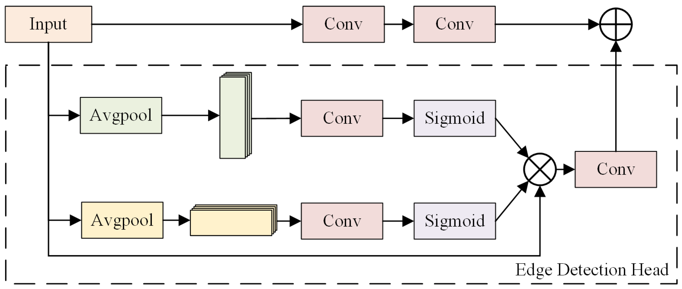
To enable effective feedback and guidance of explicit boundary information to change features, we further design an Edge Feature Aggregation Module (EFAM), as shown in Figure 4. Through direction-aware attention modeling and residual fusion mechanisms, EFAM adaptively injects boundary information into change features, reinforcing the spatial consistency and structural constraints of change regions.
As shown in Figure 4, EFAM takes the feature map F R H × W × C output by MEEM as input. Within the edge detection head branch, to effectively model the directional distribution characteristics of boundaries in spatial dimensions, EFAM utilizes a dual-branch direction-aware attention structure. Specifically, global average pooling is applied to the input feature F along the horizontal (row-wise) and vertical (column-wise) directions, producing two direction-sensitive statistical features: F x R H × 1 × C and F y R 1 × W × C . This operation not only captures long-range contextual dependencies along the horizontal direction but also preserves positional relationships along the vertical direction, facilitating more accurate localization of the spatial extent of change objects.
Subsequently, F x and F y are fed into convolutional layers, followed by a Sigmoid activation function, to generate normalized horizontal and vertical spatial attention weights W x and W y , respectively:
W x = σ ( Conv ( F x ) )
W y = σ ( Conv ( F y ) )
where σ ( · ) denotes the Sigmoid function. Each weight element reflects the likelihood of the presence of salient boundary responses along the corresponding row or column, thereby achieving precise localization of change regions.
After obtaining the attention weights, EFAM performs adaptive re-weighting of the input features via element-wise multiplication, as shown in Equation (10), to achieve fine-grained focusing on change regions:
F = F × W x × W y
To further enhance local feature consistency and discriminability, a convolutional transformation is applied to the re-weighted feature F . Meanwhile, a two-layer convolution is applied to the original feature F to perform nonlinear projection, ensuring semantic alignment between the residual path and the main path. As shown in Equation (11), to prevent excessive boundary guidance from distorting the original semantic change features, a residual connection mechanism is employed to fuse the edge-enhanced path with the original feature path:
F out = Conv ( F ) + Conv ( Conv ( F ) )
This design effectively enhances boundary clarity and spatial localization capability of change regions, providing highly discriminative input features for the subsequent change detection head.

3.5. Edge Feature Constraint Strategy

In RSCD, accurate localization of change regions relies not only on strong semantic discriminability but also heavily on the clarity of boundary structures. However, conventional training strategies usually supervise models solely with change region masks, neglecting explicit geometric constraints on change boundaries. This omission often leads to blurred boundaries, jagged artifacts, and structural discontinuities in prediction results. To address this issue, we propose an Edge Feature Constraint Strategy (EFCS), which introduces high-quality boundary supervision signals and jointly optimizes them with the change detection task, thereby imposing stable and effective edge feature constraints during training. EFCS uses edge masks generated from ground-truth labels to constrain the model’s attention, eliminating the need for additional manual boundary annotations or computational overhead during inference.
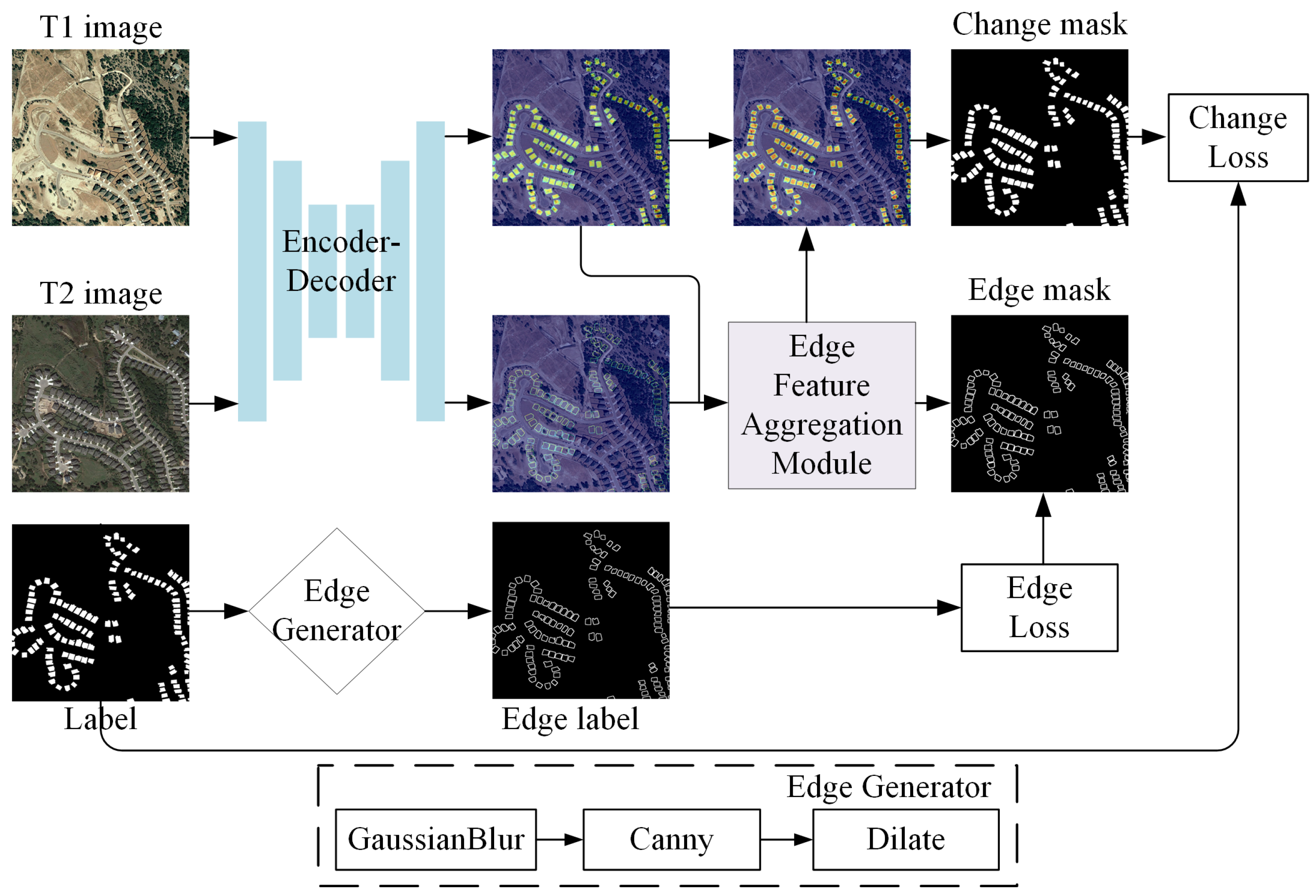
As illustrated in Figure 5, EFCS mainly consists of three key components: edge label generation, edge supervision loss, and edge-guided feedback. Given that most existing change detection datasets lack explicit boundary annotations, we design a morphology-based automatic label generation strategy to construct reliable boundary supervision signals from binary change masks during the training phase. Specifically, Gaussian filtering is first applied to the original binary change labels to suppress noise and alleviate boundary discretization. Subsequently, the Canny edge detector [27] is employed to extract initial boundaries from the smoothed masks. To further enhance boundary continuity and tolerance, a dilation operation is applied to the extracted edges, resulting in the final boundary supervision label E. This strategy enables the generation of structurally clear boundary labels with a certain width, without introducing additional manual annotation costs.
During network training, BCNet explicitly models multi-scale edge-enhanced features through the edge detection branch and outputs a predicted boundary probability map E ^ . To balance pixel-wise classification accuracy and global structural consistency, we adopt an edge loss function L edge composed of the binary cross-entropy (BCE) loss [28] and the Dice loss [29]:
L edge = L bce ( E ^ , E ) + L dice ( E ^ , E )
where L bce enforces pixel-level prediction accuracy for boundary pixels, while L dice effectively alleviates the severe class imbalance between boundary and non-boundary pixels, enhancing the structural coherence and completeness of the predicted boundaries.
To ensure that boundary information actively participates in feature learning for change detection, EFCS not only computes L edge at the output stage but also feeds the learned edge features back into the change branch through the EFAM module, enabling feature-level guidance. For the final change prediction Y ^ produced by the change detection branch, a binary cross-entropy loss is adopted to supervise the change regions:
L change = L bce ( Y ^ , Y )
Through the edge-guided feedback mechanism, the model is able to enhance boundary clarity and spatial consistency of change predictions while maintaining strong semantic discriminability. By jointly considering the change detection task and the edge feature constraint task, the overall training objective is formulated as:
L = L change + λ L edge
where λ is a weighting factor used to balance change detection accuracy and edge feature constraint strength. In this paper, λ is set to 0.3 to ensure collaborative optimization of both tasks during training.
Through the proposed edge feature constraint strategy, BCNet achieves tight coupling between semantic discrimination of change regions and boundary structure modeling during training. This effectively alleviates common issues such as boundary ambiguity and detail loss in complex scenarios, providing a stable and effective training mechanism for high-precision remote sensing image change detection.

4. Results and Discussion

4.1. Datasets and Evaluation Metrics

To systematically evaluate the generalization and robustness of BCNet across different resolutions, land cover types, and dataset scales, we conduct experiments on four representative remote sensing change detection benchmark datasets: LEVIR-CD [30], WHU-CD [31], NJDS [32], and MSRS-CD [33]. To meet network input requirements and increase sample diversity, all images are cropped into non-overlapping 512 × 512 patches and randomly split into training, validation, and test sets with a ratio of 7:1:2. The detailed characteristics of each dataset are as follows:
  • LEVIR-CD [30]: These dataset focuses on long-term building change detection. It contains 637 pairs of bi-temporal images with a spatial resolution of 0.5 m, spanning 16 years (2002–2018). The images cover various complex building instances in Texas, USA, such as high-rise apartments, villas, and garages. The main challenges include differences in illumination conditions and diverse building textures.
  • WHU-CD [31]: Derived from post-disaster reconstruction scenes in Christchurch, New Zealand, these dataset consists of ultra-large images with a resolution of 0.2 m (32,207 × 15,354 pixels). It contains changes for over 12,000 buildings, providing extremely high spatial resolution and clear boundary textures, making it an ideal benchmark for evaluating model boundary segmentation accuracy.
  • NJDS [32]: These dataset records urban updates in Nanjing from 2014 to 2018. As a typical small-to-medium scale dataset, NJDS contains diverse examples of high-, mid-, and low-rise building changes. Due to its limited sample size, it is particularly suitable for assessing a model’s feature learning capability and generalization potential under small-sample scenarios.
  • MSRS-CD [33]: As a recently released large-scale dataset, MSRS-CD comprises 841 image pairs collected from multiple cities in southern China. The scenes are highly complex, including newly constructed and demolished buildings, suburban expansion, vegetation succession, and road construction. It provides a comprehensive testbed for evaluating model performance in real-world, multi-scale, and multi-category change detection tasks.
To quantitatively evaluate model performance, five mainstream evaluation metrics are adopted in this work, including Precision (P), Recall (R), Intersection over Union (IoU), Overall Accuracy (OA), and F1-score. The corresponding mathematical formulations are illustrated in Equations (15)–(19), where TP, TN, FP, and FN represent the quantities of true positive, true negative, false positive, and false negative samples, respectively.
P r e c i s i o n = T P ( T P + F P )
R e c a l l = T P F N + T P
I o U = T P T P + F N + F P
O A = T P + T N T P + T N + F N + F P
F 1 = 2 R e c a l l 1 + P r e c i s i o n 1

4.2. Implementation Details

BCNet is built upon the PyTorch 2.4.0 deep learning framework. All experimental tests are carried out on a single NVIDIA Tesla L40 GPU equipped with 48 GB of video memory. The pre-trained SAM-Large (ViT-L) model, trained on the SA-1B dataset with 1.1 billion masks, is selected as the network backbone. In the training phase, the AdamW optimizer is utilized to update model parameters. The optimization objective adopts a combined loss function consisting of the change detection loss and edge constraint loss. The network is trained over 300 epochs to achieve sufficient convergence. The initial learning rate is configured as 0.0004, the weight decay coefficient is set to 0.05, and the batch size is fixed at 4. In terms of data augmentation, fundamental geometric and photometric augmentation strategies, including flipping, rotation and brightness adjustment are utilized. Such operations can boost the model’s generalization capability while avoiding the introduction of redundant prior bias. In our implementation, the original weights of the SAM-Large ViT backbone are completely frozen to preserve pre-trained multi-domain visual priors. Low-Rank Adaptation matrices are injected into the Query and Value projection layers across all 24 Transformer blocks. The rank r is set to 16, with scaling factor α = 32 and dropout a rate p = 0.1 .

4.3. Comparison with State-of-the-Art Methods

To objectively evaluate the performance of BCNet, we compare it against 13 current state-of-the-art (SOTA) methods. According to their technical paradigms, these methods are categorized into three groups: CNN-based methods, Transformer-based methods, and VFM-based methods.
CNN-based Methods: These methods primarily enhance performance by improving feature fusion strategies and introducing attention mechanisms.
  • FCCDN [34]: Introduces non-local feature pyramids and self-supervised constraints to enhance feature space discriminability.
  • SGSLN [35]: Proposes an interactive dual encoder-decoder architecture, using semantic guidance and spatial localization strategies to address intra-class variation.
  • AANet [36]: Utilizes a fuzzy refinement module to locate hard-to-classify samples and incorporates weight rearrangement to improve adaptation to multi-scale targets.
  • SEIFNet [37]: Constructs spatio-temporal difference enhancement modules and inter-layer fusion mechanisms to address pseudo-change interference and scale inconsistency.
Transformer-based Methods: These methods leverage self-attention mechanisms to address the challenge of modeling long-range dependencies.
  • BiT [15]: Pioneering work introducing Transformer into change detection, modeling bi-temporal spatio-temporal context via semantic tokens.
  • ChangeFormer [14]: Employs a pure Transformer Siamese architecture with hierarchical encoding to capture multi-level long-range semantic dependencies.
  • VcT [16]: Introduces Graph Neural Networks (GNNs) on top of visual Transformers to exploit contextual topological relations, enhancing detection accuracy.
  • EATDer [38]: Combines adaptive Transformer blocks with an edge-aware decoder to jointly optimize spatio-temporal modeling and boundary detail recovery.
  • MDIPNet [39]: Designs a multi-scale dual-space interaction mechanism to balance computational cost and semantic information utilization.
VFM-based Methods: These methods explore how to transfer general knowledge from large-scale pre-trained models to remote sensing tasks.
  • SAM-CD [22]: Applies FastSAM to change detection and introduces convolutional adapters to aggregate task-specific change features.
  • BAN [21]: Uses bi-temporal adaptation branches and bridging modules to effectively transfer frozen CLIP knowledge to the change detection domain.
  • TTP [6]: Employs the Time-Traveling Pixels strategy to introduce SAM’s latent knowledge into temporal evolution modeling.
  • SFCD [23]: A fine-tuning framework specifically designed for remote sensing, combining feature interaction and boundary loss to enhance SAM’s perception of fine-grained changes.
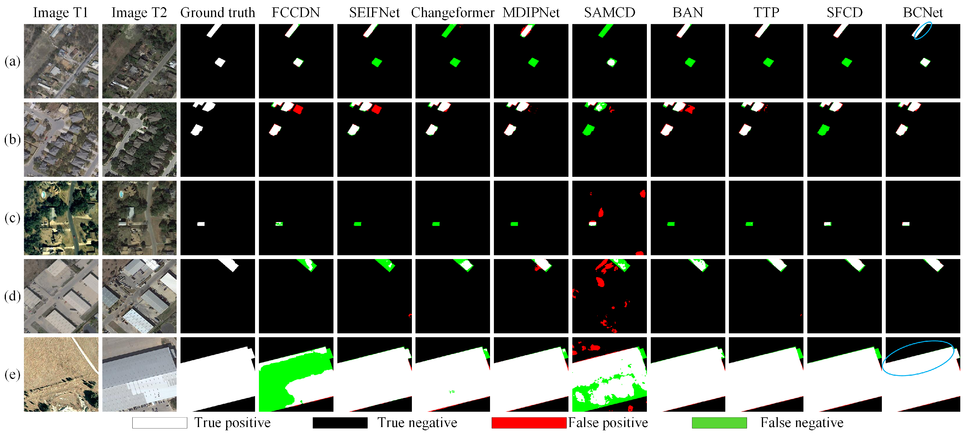
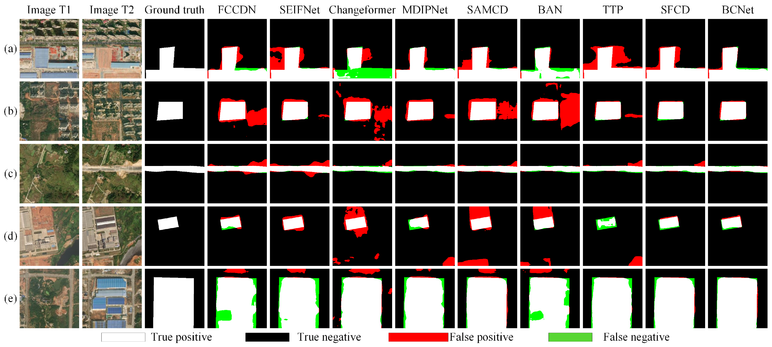
Table 1 presents the quantitative comparison of BCNet with multiple state-of-the-art methods on the LEVIR-CD dataset. The experimental results demonstrate that BCNet achieves the best performance across three core metrics: F1-score (F1), Intersection over Union (IoU), and Overall Accuracy (OA), with values of 92.54%, 86.11%, and 99.25%, respectively. Compared to the current best-performing VFM-based method, SFCD, BCNet improves F1 and IoU by 0.21% and 0.36%, indicating superior discrimination of change regions and better spatial overlap consistency. Benefiting from comprehensive multi-scale change feature modeling and the effective introduction of edge feature constraints, BCNet maintains a high Precision (93.40%) while achieving a stable Recall (91.69%), effectively reducing both false positives and false negatives. These results fully validate the robustness and superiority of the proposed method in high-resolution building change detection tasks. Furthermore, Figure 6 shows the qualitative inference results of different algorithms on the LEVIR-CD dataset. As illustrated in Figure 6a,b, in complex scenarios with densely distributed buildings, BCNet significantly reduces false positives and false negatives while maintaining clearer and more continuous change boundaries, demonstrating strong scene robustness. Thanks to the MEEM that preserves low-level spatial contours, BCNet effectively reduces missing detections for minute changes while maintaining structural integrity for large-scale targets. Figure 6c,d further shows that for single, small-scale building changes, BCNet not only accurately identifies change regions but also finely depicts boundary details, highlighting its advantage in fine-grained change detection. In Figure 6e, BCNet demonstrates superior performance in large-scale change boundaries, producing more complete and clear change contours. Overall, BCNet exhibits excellent robustness, boundary fidelity, and detail perception in high-resolution remote sensing change detection.
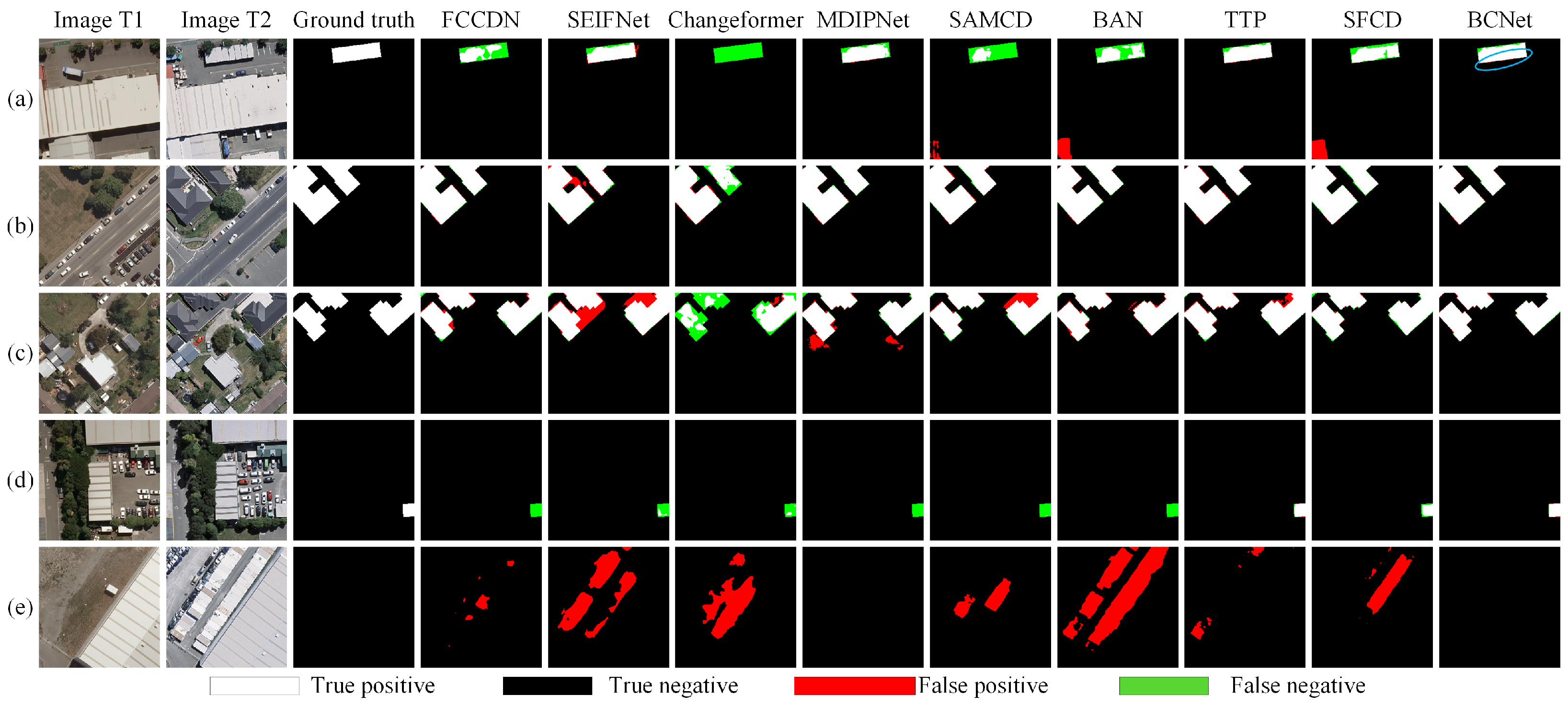
Table 2 reports the quantitative comparison on the WHU-CD dataset. BCNet achieves the best performance across all five evaluation metrics, with F1-score and IoU reaching 92.07% and 85.31%, respectively, improving 0.71% and 1.21% over the second-best VFM-based method, TTP. Notably, BCNet maintains a high Precision of 97.29% while significantly improving Recall to 87.39%, effectively addressing the challenge of internal voids in large buildings present in high-resolution imagery. As shown in Figure 7a, the generated change maps are uniformly filled, ensuring high boundary closure. Figure 7b,c demonstrates that in densely distributed building areas, BCNet clearly separates adjacent objects and accurately delineates building clusters. Figure 7d highlights its high sensitivity to small individual buildings, while Figure 7e shows that BCNet effectively avoids misclassifying non-building changes such as containers or vehicles, demonstrating strong class discrimination and scene adaptability.
Table 3 presents the performance comparison on the NJDS dataset, which features a small sample size, diverse building types, and uneven change distributions, imposing higher requirements on model generalization and change sensitivity under limited data. BCNet achieves overall optimal performance on these datasets, significantly outperforming comparison methods in F1-score, IoU, and OA. Specifically, BCNet attains an F1-score of 79.75%, an IoU of 65.87%, and OA of 98.12%, improving 6.33% and 5.38% in F1 and IoU over the second-best VFM-based method, SAMCD. Figure 8 further visualizes the detection results, showing that even under limited training data, BCNet consistently identifies changes of varying building sizes with clear boundaries and intact structures, validating the effectiveness of the proposed DDEM and edge feature constraint mechanisms in enhancing model generalization.
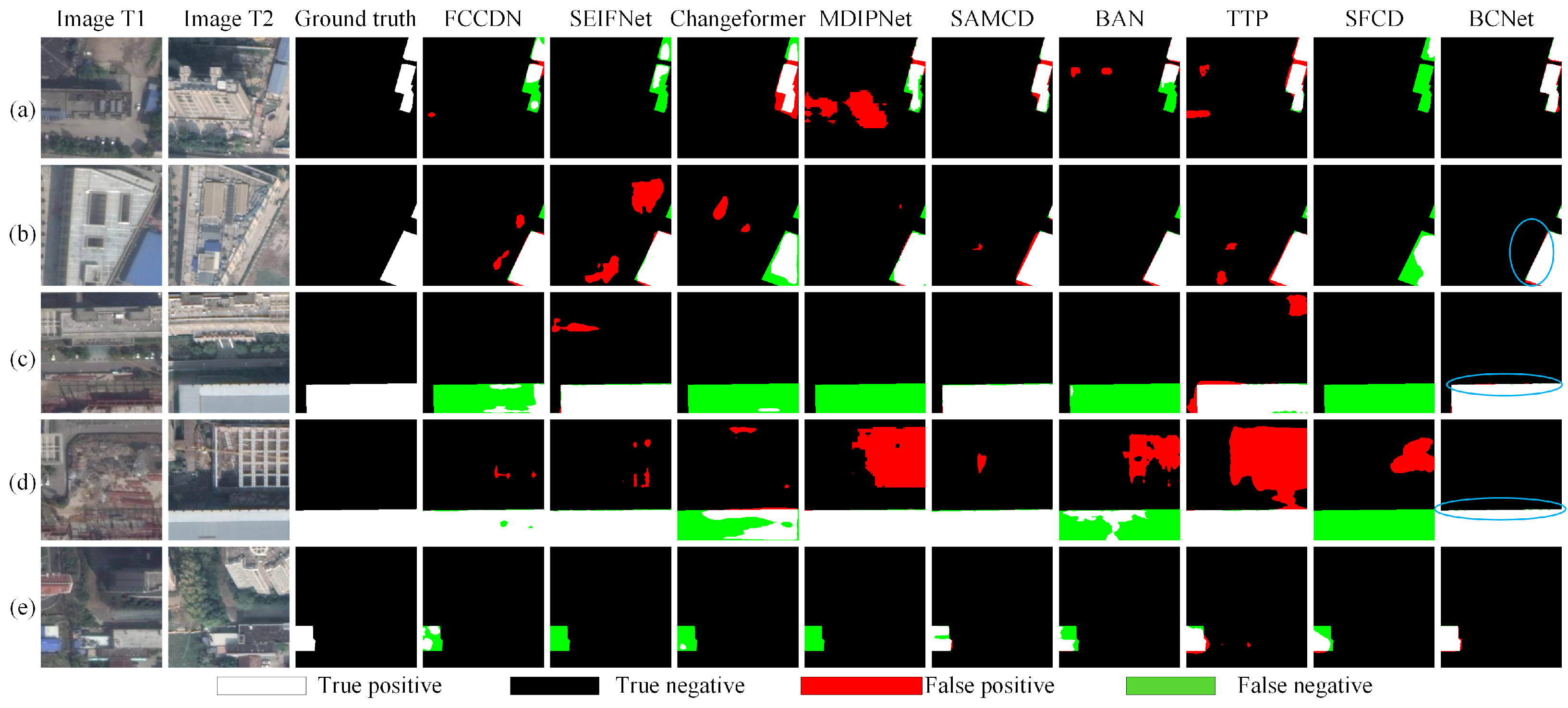
The SOTA comparison results on the MSRS-CD dataset are summarized in Table 4. BCNet achieves the best overall performance, with F1-score, IoU, and OA reaching 79.60%, 65.75%, and 94.67%, respectively, significantly outperforming other methods. Compared to the current top-performing VFM-based method TTP, BCNet improves F1 and IoU by 0.63% and 0.50%, with OA increasing by 0.97%, indicating stronger overall prediction accuracy and spatial consistency in change regions. The qualitative results in Figure 9a–d further confirm BCNet’s boundary delineation capability in complex scenes, accurately and continuously depicting change boundaries while reducing missed detections, especially for slender or irregular targets. Figure 9e highlights BCNet’s advantage in detecting large-scale change regions, demonstrating its robustness and generalization capability in complex multi-scale change scenarios. It is worth noting that while benchmark datasets such as LEVIR-CD and WHU-CD primarily evaluate building change detection, the MSRS-CD dataset contains diverse change classes including roads, vegetation, and land cover. BCNet’s consistent superiority across all four datasets highlights that the proposed edge-constrained mechanism is not restricted to rigid building boundaries but generalizes effectively to arbitrary multi-class change targets with complex geometric contours.

4.4. Model Complexity Analysis

To comprehensively evaluate the efficiency and practicality of the proposed method, Table 5 presents a detailed comparison of complexity and performance for different change detection methods on the LEVIR-CD dataset in terms of F1 score, IoU, FLOPs, Parameters (Params), and Inference time. It is worth noting that this paper consistently uses the Torch-OpCounter library to evaluate the models’ FLOPs and parameters. To ensure fairness in the comparative experiments, ‘input size’ is set to [(3, 256, 256), (3, 256, 256)], ‘batch size’ is set to 1, and ‘device’ is set to ‘cpu’.
The results show that BCNet achieves an F1 score of 92.54% and an IoU of 86.11% while maintaining a favorable balance between computational cost and model size. Specifically, BCNet requires 44.79 G FLOPs and contains 48.65 M parameters. Compared with other VFM-based methods, its parameter count is significantly lower than BAN’s 80.30 M, and its computational overhead is substantially lower than TTP’s 51.06 G FLOPs and SFCD’s 52.14 G FLOPs. Although BCNet’s computational cost is higher than lightweight models such as BIT (8.75 G FLOPs and 3.04 M parameters), the performance gain far outweighs the increase in complexity. For example, compared to BIT’s F1 score of 89.94%, BCNet improves by 2.6%, demonstrating a high efficiency-to-performance ratio. Notably, some high-parameter models, such as SEIFNet and MDIPNet, do not achieve corresponding performance gains, with their F1 and IoU scores falling behind BCNet. This indicates that simply increasing model capacity is not an effective strategy for improving detection accuracy.
In contrast, BCNet leverages parameter-efficient boundary-aware module designs and edge feature constraint strategies, fully exploiting SAM’s semantic priors while avoiding redundancy introduced by full-parameter fine-tuning. This achieves a superior balance between performance improvement and complexity control.
In summary, BCNet demonstrates leading accuracy and efficiency trade-offs among VFMs-based methods. It not only surpasses existing SOTA performance but also offers practical feasibility for deployment, making it particularly suitable for remote sensing change detection applications with strict accuracy and efficiency requirements.

4.5. Ablation Study

4.5.1. Ablation of Different Modules

To systematically verify the contribution of each core module to the overall performance, we conducted ablation experiments on two representative datasets, LEVIR-CD and MSRS-CD. As shown in Table 6, we evaluated the individual and joint effects of the Difference-Detail Enhancement Module (DDEM), Multi-scale Edge Enhancement Module (MEEM), and Edge Feature Aggregation Module (EFAM).
Under the baseline setting without any additional modules, where change features are computed using only the conventional absolute difference, the model achieves limited performance on both datasets. The F1 scores on LEVIR-CD and MSRS-CD are 85.37% and 72.46%, respectively, and the IoU scores are 76.65% and 56.26%. This indicates that relying solely on basic semantic features is insufficient for complex change scenarios, especially in MSRS-CD, which contains multi-class and multi-scale changes.
Introducing DDEM alone significantly improves performance. On LEVIR-CD, F1 increases to 90.65% and IoU to 82.86%, while on MSRS-CD, F1 and IoU reach 74.54% and 59.66%, respectively. These results demonstrate that explicit difference modeling effectively enhances the model’s discriminability for changes across two temporal images, particularly in suppressing interference from temporally consistent regions.
When MEEM was introduced on its own, the model also achieved significant improvements. Compared to the baseline model, the F1 score and IoU on the LEVIR-CD dataset increased to 91.02% and 83.55%, respectively, while the F1 score and IoU on the MSRS-CD dataset reached 75.65% and 60.73%. This indicates that multi-scale edge modeling plays a crucial role in enhancing boundary representation and improving detection accuracy in areas with complex structures.
Similarly, introducing EFAM alone results in clear performance improvements over the baseline. On LEVIR-CD, F1 and IoU are 90.66% and 82.94%, and on MSRS-CD, 75.44% and 60.58%. This indicates that the feedback of edge information into the change features effectively strengthens spatial constraints, improving boundary consistency in predictions.
When DDEM, MEEM, and EFAM are simultaneously incorporated, the model achieves optimal performance on both datasets. LEVIR-CD F1 and IoU reach 92.54% and 86.11%, while MSRS-CD F1 and IoU increase to 79.60% and 65.75%. Compared with single-module configurations, the multi-module synergy produces more significant performance gains, confirming the functional complementarity of each module: DDEM highlights change-specific features, MEEM reinforces multi-scale boundary information, and EFAM effectively feeds edge features back into the change prediction process. Their combined effect comprehensively enhances both change discriminability and boundary delineation.
In summary, the ablation study fully demonstrates the necessity and synergistic benefit of each module, which are key factors for improving performance in complex remote sensing change detection scenarios.
To validate the effectiveness of the VFM, we replace the SAM-Large backbone with a ResNet-50 pretrained on ImageNet-1k. As shown in Table 7, the model utilizing the SAM-Large backbone outperforms the ResNet-50 baseline, achieving a 3.12% higher F1-score and a 5.25% higher IoU. These results demonstrate the superior feature representation capability of VFMs pretrained on large-scale datasets like SA-1B.

4.5.2. Ablation Study of Edge Feature Constraint Strategy

To systematically verify the effectiveness of the Edge Feature Constraint Strategy (EFCS) for boosting boundary positioning precision and detection performance, an ablation baseline is established by removing the EFCS module, namely discarding the edge detection branch and its corresponding loss terms. Comparative experiments between this baseline and the complete BCNet are conducted on the LEVIR-CD and MSRS-CD datasets, and quantitative results are listed in Table 8. As indicated by the experimental data, the exclusion of EFCS brings evident performance degeneration. On the LEVIR-CD dataset, the F1-score and IoU decline by 1.22% and 2.00%, respectively. More pronouncedly, on the complex MSRS-CD dataset, the absence of edge feature constraints causes the F1 score and IoU to drop sharply by 4.02% and 5.05%. This substantial performance degradation clearly demonstrates that relying solely on semantic features is insufficient for precise change localization in complex scenarios. In contrast, EFCS introduces explicit geometric supervision, forcing the model to focus on the edge structures of change regions, effectively suppressing boundary blurring and adhesion, and thus plays a key role in improving model robustness.
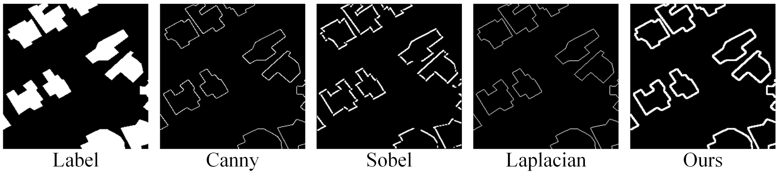
Furthermore, to analyze the impact of different edge generation strategies within EFCS on overall performance, we conducted comparative experiments using various Edge Generators, including Canny [27], Sobel [40], Laplacian [41], and the method proposed in this work. The results are reported in Table 9. The experiments show that edge generation based on traditional operators can improve performance to some extent, but the overall effect remains slightly lower than our proposed method. Among traditional operators, Canny and Laplacian achieve relatively better results on both LEVIR-CD and MSRS-CD, whereas Sobel provides limited improvement. In contrast, our method employs Gaussian smoothing to suppress noise and incorporates dilation to enhance edge continuity and width, constructing robust labels with a tolerance margin. This enables the model to achieve the optimal IoU scores of 86.11% and 65.75% on LEVIR-CD and MSRS-CD, respectively.
These results indicate that the proposed edge generation strategy better aligns with the requirements of change detection tasks, producing edge features that are more continuous, complete, and consistent with true change boundaries. Figure 10 provides a visual comparison of different edge generators. It can be observed that edges generated by Sobel and Laplacian contain many discontinuities and background noise. The standard Canny operator produces accurately located but discontinuous edges. In contrast, the edges generated by our method are structurally complete and continuous, effectively eliminating artifacts and providing the most accurate and stable boundary supervision signals for the model.
To further investigate the influence of the balancing factor λ in EFCS, we conducted a parameter sensitivity analysis by assigning different values to λ . The experiments were performed on the LEVIR-CD and MSRS-CD datasets, and the results are reported in Table 10. The model performance first improves and then declines as λ increases. Specifically, when λ is set to 0.3, the proposed method achieves the best performance on both datasets, obtaining an F1 score of 92.54% and an IoU of 86.11% on LEVIR-CD, as well as an F1 score of 79.60% and an IoU of 65.75% on MSRS-CD. When λ is smaller (e.g., 0.1 or 0.2), the enhancement effect of EFCS is insufficient, leading to suboptimal feature representation. Conversely, when λ exceeds 0.3, excessive emphasis on EFCS gradually weakens the balance between semantic and boundary information, resulting in a decline in detection performance, particularly on the more challenging MSRS-CD dataset. These results demonstrate that λ = 0.3 provides the best trade-off between feature enhancement and information preservation and is therefore adopted in all subsequent experiments.


5. Conclusions

This paper proposes a boundary-constrained change detection network based on vision foundation models (BCNet), fully leveraging the universal semantic representation potential of pre-trained VFMs. By introducing a differential detail enhancement module and a multi-scale edge enhancement module, it addresses the loss of high-frequency information during direct VFM transfer, enabling precise characterization of minute changes and complex textures. Furthermore, a edge feature constraint mechanism was designed to introduce supervisory signals in both the feature and prediction spaces, enhancing the spatial continuity and geometric integrity of the change detection results. Experimental results demonstrate that BCNet achieves state-of-the-art performance on four datasets—LEVIR-CD, WHU-CD, NJDS, and MSRS-CD. Notably, it exhibits superior robustness and accuracy compared to 13 mainstream methods in challenging scenarios such as densely built-up areas and complex edges.
Looking forward, we aim to further improve BCNet’s computational efficiency and multimodal generalization capabilities. On the one hand, we plan to explore knowledge-distillation-based lightweight strategies to enable practical deployment of large models at the edge for remote sensing applications. On the other hand, we will extend this framework to heterogeneous data change detection tasks, further exploiting the broad application potential of vision foundation models.

Author Contributions

Conceptualization, S.L. and L.T.; methodology, S.L.; software, S.L. and H.H.; validation, S.L. and D.Z.; formal analysis, S.L.; investigation, S.L.; resources, S.L.; data curation, S.L. and H.H.; writing—original draft preparation, S.L.; writing—review and editing, S.L. and L.T.; visualization, S.L. and D.Z.; supervision, S.L. and L.T.; project administration, S.L. and L.T.; funding acquisition, L.T. All authors have read and agreed to the published version of the manuscript.

Funding

This research was funded by Water Resources Science and Technology Program of Hunan Province grant number No. XSKJ2025056-32.

Data Availability Statement

The raw data supporting the conclusions of this article will be made available by the authors on request.

Acknowledgments

The authors would like to express sincere gratitude to the School of Physical Electronics, Changsha University of Science and Technology, for providing powerful GPU computing resources that substantially supported the experimental implementation of this study. We also gratefully acknowledge the Soil and Water Conservation Monitoring Center of the Ministry of Water Resources of China for offering reliable experimental environments and essential research conditions. Furthermore, we sincerely appreciate the valuable comments and constructive suggestions from the editors and anonymous reviewers, which have greatly improved the overall quality and presentation of this manuscript. During the preparation of this work, the authors used ChatGpt 5 Sonnet to improve language clarity and readability. After using this tool, the authors carefully reviewed and revised the content as needed and take full responsibility for the final version of the manuscript.

Conflicts of Interest

The authors declare no conflicts of interest.

Abbreviations

The following abbreviations are used in this manuscript:
RSCDRemote Sensing Change Detection
CNNsConvolutional Neural Networks
ViTsVision Transformers
VFMsVision foundation models
LoRALow-Rank Adaptation
SAMSegment Anything Model
SOTAState-of-the-art

References

  1. Singh, A. Review article digital change detection techniques using remotely-sensed data. Int. J. Remote Sens. 1989, 10, 989–1003. [Google Scholar] [CrossRef] [Scilit]
  2. Han, P.; Ma, C.; Li, Q.; Leng, P.; Bu, S.; Li, K. Aerial image change detection using dual regions of interest networks. Neurocomputing 2019, 349, 190–201. [Google Scholar] [CrossRef] [Scilit]
  3. Chen, B.; Chen, Z.; Deng, L.; Duan, Y.; Zhou, J. Building change detection with RGB-D map generated from UAV images. Neurocomputing 2016, 208, 350–364. [Google Scholar] [CrossRef] [Scilit]
  4. Guo, Y.; Xu, Y.; Tang, G.; Yu, Z.; Zhao, Q.; Tang, Q. AM-CD: Joint attention and Mamba for remote sensing image change detection. Neurocomputing 2025, 647, 130607. [Google Scholar] [CrossRef] [Scilit]
  5. Zhu, D.; Xia, S.; Zhao, J.; Zhou, Y.; Jian, M.; Niu, Q.; Yao, R.; Chen, Y. Diverse sample generation with multi-branch conditional generative adversarial network for remote sensing objects detection. Neurocomputing 2020, 381, 40–51. [Google Scholar] [CrossRef] [Scilit]
  6. Chen, K.; Liu, C.; Li, W.; Liu, Z.; Chen, H.; Zhang, H.; Zou, Z.; Shi, Z. Time travelling pixels: Bitemporal features integration with foundation model for remote sensing image change detection. In Proceedings of the IGARSS 2024—2024 IEEE International Geoscience and Remote Sensing Symposium, Athens, Greece, 7–12 July 2024; pp. 8581–8584. [Google Scholar]
  7. Kirillov, A.; Mintun, E.; Ravi, N.; Mao, H.; Rolland, C.; Gustafson, L.; Xiao, T.; Whitehead, S.; Berg, A.C.; Lo, W.-Y.; et al. Segment anything. In Proceedings of the IEEE/CVF International Conference on Computer Vision (ICCV), Paris, France, 1–6 October 2023; pp. 4015–4026. [Google Scholar]
  8. Dong, S.; Wang, L.; Du, B.; Meng, X. ChangeCLIP: Remote sensing change detection with multimodal vision-language representation learning. ISPRS J. Photogramm. Remote Sens. 2024, 208, 53–69. [Google Scholar] [CrossRef] [Scilit]
  9. Radford, A.; Kim, J.W.; Hallacy, C.; Ramesh, A.; Goh, G.; Agarwal, S.; Sastry, G.; Askell, A.; Mishkin, P.; Clark, J.; et al. Learning transferable visual models from natural language supervision. In Proceedings of the International Conference on Machine Learning (ICML), Virtual Event, 18–24 July 2021; pp. 8748–8763. [Google Scholar]
  10. Daudt, R.C.; Le Saux, B.; Boulch, A. Fully convolutional siamese networks for change detection. In Proceedings of the 2018 25th IEEE International Conference on Image Processing (ICIP), Athens, Greece, 7–10 October 2018; pp. 4063–4067. [Google Scholar]
  11. Peng, D.; Zhang, Y.; Guan, H. End-to-end change detection for high resolution satellite images using improved UNet++. Remote Sens. 2019, 11, 1382. [Google Scholar] [CrossRef] [Scilit]
  12. Fang, S.; Li, K.; Shao, J.; Li, Z. SNUNet-CD: A densely connected Siamese network for change detection of VHR images. IEEE Geosci. Remote Sens. Lett. 2021, 19, 8007805. [Google Scholar] [CrossRef] [Scilit]
  13. Zhang, C.; Wang, L.; Cheng, S.; Li, Y. SwinSUNet: Pure transformer network for remote sensing image change detection. IEEE Trans. Geosci. Remote Sens. 2022, 60, 6000713. [Google Scholar] [CrossRef] [Scilit]
  14. Bandara, W.G.C.; Patel, V.M. A transformer-based siamese network for change detection. In Proceedings of the IGARSS 2022—2022 IEEE International Geoscience and Remote Sensing Symposium, Kuala Lumpur, Malaysia, 17–22 July 2022; pp. 207–210. [Google Scholar]
  15. Chen, H.; Qi, Z.; Shi, Z. Remote sensing image change detection with transformers. IEEE Trans. Geosci. Remote Sens. 2021, 60, 5607514. [Google Scholar] [CrossRef] [Scilit]
  16. Jiang, B.; Wang, Z.; Wang, X.; Zhang, Z.; Chen, L.; Wang, X.; Luo, B. VcT: Visual change transformer for remote sensing image change detection. IEEE Trans. Geosci. Remote Sens. 2023, 61, 2005214. [Google Scholar] [CrossRef] [Scilit]
  17. Zhao, X.; Ding, W.; An, Y.; Du, Y.; Yu, T.; Li, M.; Tang, M.; Wang, J. Fast segment anything. arXiv 2023, arXiv:2306.12156. [Google Scholar]
  18. Ravi, N.; Gabeur, V.; Hu, Y.T.; Hu, R.; Ryali, C.; Ma, T.; Khedr, H.; Rädle, R.; Roll, C.; Gustafson, L.; et al. SAM 2: Segment anything in images and videos. In Proceedings of the International Conference on Learning Representations (ICLR), Singapore, 24–28 April 2025. [Google Scholar]
  19. Zhang, Y.; Cheng, J.; Xia, Z.; Liu, S.; Deng, C.; Zhu, Z.; Chen, Z. Multi-feature collaboration with spatial-frequency learning guided by vision foundation model for remote sensing image captioning. Neurocomputing 2026, 676, 132936. [Google Scholar] [CrossRef] [Scilit]
  20. Joshi, K.; Li, X.; Windisch, T.; König, M. From detection to segmentation: Combining foundation model with bounding boxes for efficient fire detection. Neurocomputing 2025, 647, 130513. [Google Scholar] [CrossRef] [Scilit]
  21. Li, K.; Cao, X.; Meng, D. A new learning paradigm for foundation model-based remote-sensing change detection. IEEE Trans. Geosci. Remote Sens. 2024, 62, 5610112. [Google Scholar] [CrossRef] [Scilit]
  22. Ding, L.; Zhu, K.; Peng, D.; Tang, H.; Yang, K.; Bruzzone, L. Adapting segment anything model for change detection in VHR remote sensing images. IEEE Trans. Geosci. Remote Sens. 2024, 62, 5611711. [Google Scholar] [CrossRef] [Scilit]
  23. Zhang, D.; Wang, F.; Ning, L.; Zhao, Z.; Gao, J.; Li, X. Integrating SAM with feature interaction for remote sensing change detection. IEEE Trans. Geosci. Remote Sens. 2024, 62, 4513011. [Google Scholar] [CrossRef] [Scilit]
  24. Qin, Y.; Wang, C.; Fan, Y.; Pan, C. SAM2-CD: Remote sensing image change detection with SAM2. IEEE J. Sel. Top. Appl. Earth Obs. Remote Sens. 2025, 18, 24575–24587. [Google Scholar] [CrossRef] [Scilit]
  25. Mo, N.; Ma, G.; Xie, D.; Zhang, G. SAM2-MDESD: An SAM2-Assisted Multilevel Dual Encoder–Single Decoder Method for Optical Remote Sensing Image Change Detection. IEEE J. Sel. Top. Appl. Earth Obs. Remote Sens. 2025, 19, 2588–2604. [Google Scholar] [CrossRef] [Scilit]
  26. Hu, E.J.; Shen, Y.; Wallis, P.; Allen-Zhu, Z.; Li, Y.; Wang, S.; Wang, L.; Chen, W. LoRA: Low-rank adaptation of large language models. In Proceedings of the International Conference on Learning Representations (ICLR), Virtual, 25–29 April 2022. [Google Scholar]
  27. Canny, J. A computational approach to edge detection. IEEE Trans. Pattern Anal. Mach. Intell. 1986, 8, 679–698. [Google Scholar] [CrossRef] [Scilit]
  28. Rumelhart, D.E.; Hinton, G.E.; Williams, R.J. Learning representations by back-propagating errors. Nature 1986, 323, 533–536. [Google Scholar] [CrossRef] [Scilit]
  29. Milletari, F.; Navab, N.; Ahmadi, S.-A. V-Net: Fully convolutional neural networks for volumetric medical image segmentation. In Proceedings of the Fourth International Conference on 3D Vision (3DV), Stanford, CA, USA, 25–28 October 2016; pp. 565–571. [Google Scholar]
  30. Chen, H.; Shi, Z. A spatial-temporal attention-based method and a new dataset for remote sensing image change detection. Remote Sens. 2020, 12, 1662. [Google Scholar] [CrossRef] [Scilit]
  31. Ji, S.; Wei, S.; Lu, M. Fully convolutional networks for multisource building extraction from an open aerial and satellite imagery data set. IEEE Trans. Geosci. Remote Sens. 2018, 57, 574–586. [Google Scholar] [CrossRef] [Scilit]
  32. Shen, Q.; Huang, J.; Wang, M.; Tao, S.; Yang, R.; Zhang, X. Semantic feature-constrained multitask Siamese network for building change detection in high-spatial-resolution remote sensing imagery. ISPRS J. Photogramm. Remote Sens. 2022, 189, 78–94. [Google Scholar] [CrossRef] [Scilit]
  33. Liu, S.; Zhao, D.; Zhou, Y.; Tan, Y.; He, H.; Zhang, Z.; Tang, L. Network and dataset for multiscale remote sensing image change detection. IEEE J. Sel. Top. Appl. Earth Obs. Remote Sens. 2024, 18, 2851–2866. [Google Scholar] [CrossRef] [Scilit]
  34. Chen, P.; Zhang, B.; Hong, D.; Chen, Z.; Yang, X.; Li, B. FCCDN: Feature constraint network for VHR image change detection. ISPRS J. Photogramm. Remote Sens. 2022, 187, 101–119. [Google Scholar] [CrossRef] [Scilit]
  35. Zhao, S.; Zhang, X.; Xiao, P.; He, G. Exchanging dual-encoder–decoder: A new strategy for change detection with semantic guidance and spatial localization. IEEE Trans. Geosci. Remote Sens. 2023, 61, 4508016. [Google Scholar] [CrossRef] [Scilit]
  36. Hang, R.; Xu, S.; Yuan, P.; Liu, Q. AANet: An ambiguity-aware network for remote-sensing image change detection. IEEE Trans. Geosci. Remote Sens. 2024, 62, 5606411. [Google Scholar] [CrossRef] [Scilit]
  37. Huang, Y.; Li, X.; Du, Z.; Shen, H. Spatiotemporal enhancement and interlevel fusion network for remote sensing images change detection. IEEE Trans. Geosci. Remote Sens. 2024, 62, 5609414. [Google Scholar] [CrossRef] [Scilit]
  38. Ma, J.; Duan, J.; Tang, X.; Zhang, X.; Jiao, L. EATDer: Edge-assisted adaptive transformer detector for remote sensing change detection. IEEE Trans. Geosci. Remote Sens. 2023, 62, 5602015. [Google Scholar] [CrossRef] [Scilit]
  39. Chang, H.; Wang, P.; Diao, W.; Xu, G.; Sun, X. Remote sensing change detection with bitemporal and differential feature interactive perception. IEEE Trans. Image Process. 2024, 33, 4543–4555. [Google Scholar] [CrossRef] [Scilit] [PubMed]
  40. Sobel, I.; Feldman, G. A 3 × 3 Isotropic Gradient Operator for Image Processing; Stanford Artificial Intelligence Project: Stanford, CA, USA, 1968. [Google Scholar]
  41. Marr, D.; Hildreth, E. Theory of edge detection. Proc. R. Soc. Lond. Ser. B Biol. Sci. 1980, 207, 187–217. [Google Scholar] [CrossRef] [Scilit] [PubMed]
Figure 1. Detailed illustration of BCNet. Includes a SAM image encoder with shared weights, LoRA adapter, differential detail enhancement module, multi-scale edge enhancement module, edge feature aggregation module, and two detection heads.
Remotesensing 18 02760 g001
Figure 2. The structure of the DDEM.
Remotesensing 18 02760 g002
Figure 3. The structure of the MEEM.
Remotesensing 18 02760 g003
Figure 4. The structure of the EFAM.
Remotesensing 18 02760 g004
Figure 5. The structure of the EFCS.
Remotesensing 18 02760 g005
Figure 6. Visual comparisons of representative algorithms on the LEVIR-CD dataset are presented herein. Subfigures (ae) correspond to the detection outcomes obtained from the LEVIR-CD dataset.
Remotesensing 18 02760 g006
Figure 7. Visual comparisons of representative algorithms on the WHU-CD dataset are presented herein. Subfigures (ae) correspond to the detection outcomes obtained from the WHU-CD dataset.
Remotesensing 18 02760 g007
Figure 8. Visual comparisons of representative algorithms on the NJDS dataset are presented herein. Subfigures (ae) correspond to the detection outcomes obtained from the NJDS dataset.
Remotesensing 18 02760 g008
Figure 9. Visual comparisons of representative algorithms on the MSRS-CD dataset are presented herein. Subfigures (ae) correspond to the detection outcomes obtained from the MSRS-CD dataset.
Remotesensing 18 02760 g009
Figure 10. Visualization of different Edge Generator outputs.
Remotesensing 18 02760 g010
Table 1. Comparison with Other SOTA Models on the LEVIR-CD Dataset, where bold values denote the optimal results.
MethodsTypeP (%)R (%)F1 (%)IoU (%)OA (%)
FCCDNCNN92.1790.4991.3283.0499.12
SGSLN92.6390.7191.6683.6499.16
AANet92.1087.7489.8781.6098.99
SEIFNet91.8288.0389.8981.6398.99
BITTransformer90.3389.5689.9481.7298.98
Changeformer92.0588.8090.4082.4899.04
VcT92.5787.6590.0481.8999.01
EATDer85.7392.9789.2080.5198.85
MDIPNet92.0490.2291.1283.6999.14
SAMCDVFM90.7291.4291.0683.6099.09
BAN93.5590.7092.1085.3699.21
TTP93.1891.3592.2685.6299.22
SFCD92.9791.6992.3385.7599.22
BCNetVFM93.4091.6992.5486.1199.25
Table 2. Comparison with Other SOTA Models on the WHU-CD Dataset, where bold values denote the optimal results.
MethodsTypeP (%)R (%)F1 (%)IoU (%)OA (%)
FCCDNCNN95.2483.5889.0379.8599.01
SGSLN95.5384.3889.6180.7999.06
AANet77.1280.9779.0065.2997.92
SEIFNet88.7282.0885.2774.3398.63
BITTransformer78.4884.1381.2168.4698.12
Changeformer88.0876.9282.1269.6798.38
VcT83.0780.0981.5568.8598.25
EATDer87.9785.4886.7176.5398.73
MDIPNet96.4482.7689.0880.3199.02
SAMCDVFM96.9078.6386.8176.7098.85
BAN96.0983.5289.3780.7899.04
TTP96.1187.0691.3684.1099.21
SFCD96.7685.9791.0483.5699.18
BCNetVFM97.2987.3992.0785.3199.27
Table 3. Comparison with Other SOTA Models on the NJDS Dataset, where bold values denote the optimal results.
MethodsTypeP (%)R (%)F1 (%)IoU (%)OA (%)
FCCDNCNN87.7948.7362.6845.3896.19
SGSLN83.5958.4268.7752.2296.51
AANet79.5754.1964.4747.5796.08
SEIFNet85.6654.2766.4549.7596.40
BITTransformer71.8155.7962.7945.7795.66
Changeformer85.5331.5946.1429.9995.15
VcT80.1446.1558.5741.4195.71
EATDer61.6350.8555.6138.5294.67
MDIPNet85.9059.9870.6454.6196.72
SAMCDVFM87.5266.2075.3860.4997.16
BAN90.8546.0861.1444.0396.15
TTP57.2782.5367.6251.0898.00
SFCD62.6758.1360.3243.1894.97
BCNetVFM87.7876.4381.7165.8798.12
Table 4. Comparison with Other SOTA Models on the MSRS-CD Dataset, where bold values denote the optimal results.
MethodsTypeP (%)R (%)F1 (%)IoU (%)OA (%)
FCCDNCNN75.5671.3173.3755.4292.36
SGSLN77.3969.7373.3656.2892.52
AANet71.9477.0374.4059.2392.17
SEIFNet75.2475.4675.2460.3092.67
BITTransformer75.7370.7973.1857.7092.34
Changeformer72.2272.9472.5856.9691.86
VcT76.6469.7273.0257.5092.39
EATDer66.7384.1774.4459.2991.47
MDIPNet81.1470.2475.3060.3893.19
SAMCDVFM72.9080.5376.5361.9892.71
BAN79.3672.8975.9961.2793.20
TTP77.8180.1678.9765.2593.70
SFCD76.6480.2878.4264.4993.47
BCNetVFM79.4979.7179.6065.7594.67
Table 5. Analysis of Model Complexity for Various Networks on the LEVIR-CD Dataset.
MethodsTypeF1IoUFLOPs (G)Param (M)Inference Time (ms)
FCCDNCNN91.3283.0412.496.3115.29
SGSLN91.6683.6411.506.0410.31
AANet89.8781.6024.2115.8210.63
SEIFNet89.8981.638.3727.9111.54
BITTransformer89.9481.728.753.0411.58
Changeformer90.4082.48202.7941.0328.78
VcT90.0481.8910.643.5714.68
EATDer89.2080.5123.466.6121.18
MDIPNet91.1283.6914.1040.2123.58
SAMCDVFM91.0683.608.6070.59201.59
BAN92.1085.3633.1780.3076.22
TTP92.2685.6251.0639.8988.56
SFCD92.3385.7552.1444.0989.06
BCNetVFM92.5486.1144.7948.6587.45
Table 6. Results of Ablation Experiments on the LEVIR-CD Dataset and the MSRS-CD Dataset.
DDEMMEEMEFAMLEVIR-CDMSRS-CD
F1 (%)IoU (%)F1 (%)IoU (%)
85.3776.6572.4656.26
90.6582.8674.5459.66
91.0283.5575.6560.73
90.6682.9475.4460.58
92.5486.1179.6065.75
Table 7. Comparative Experiments on Pre-trained Skeleton Networks Using the LEVIR-CD Dataset.
BackbonePre-TrainingF1 (%)IoU (%)
ResNet-50ImageNet-1k89.4280.86
SAM-LargeSA-1B92.5486.11
Table 8. Ablation study of EFCS on the LEVIR-CD and MSRS-CD datasets.
EFCSLEVIR-CDMSRS-CD
F1IoUF1IoU
91.3284.1175.5860.70
92.5486.1179.6065.75
Table 9. Ablation study of edge generator in EFCS on the LEVIR-CD and MSRS-CD datasets, ‘Ours’ refers to a complete edge generation pipeline consisting of Gaussian blurring, the Canny operator, and morphological dilation.
MethodsLEVIR-CDMSRS-CD
F1IoUF1IoU
Canny92.4385.9079.2165.22
Sobel91.7784.8078.5064.75
Laplacian92.3185.7279.3365.43
Ours92.5486.1179.6065.75
Table 10. The Effect of the λ Value in EFCS on LEVIR-CD and MSRS-CD.
MethodsLEVIR-CDMSRS-CD
F1IoUF1IoU
0.191.6583.6478.4364.67
0.292.1785.4878.9865.27
0.392.5486.1179.6065.75
0.492.2385.6478.9365.21
0.592.1085.3576.6862.34
Disclaimer/Publisher’s Note: The statements, opinions and data contained in all publications are solely those of the individual author(s) and contributor(s) and not of MDPI and/or the editor(s). MDPI and/or the editor(s) disclaim responsibility for any injury to people or property resulting from any ideas, methods, instructions or products referred to in the content.