A Geometry-Constrained Framework for Automatic Geometric Positioning Accuracy Assessment of Large-Scale Satellite Imagery

Highlights
- A geometry-constrained hierarchical framework is proposed for automatic geometric positioning accuracy assessment of large-scale satellite imagery without ground control points.
- The proposed framework significantly improves matching robustness and positioning accuracy estimation under challenging remote sensing conditions, including large initial positioning errors, weak textures, cloud contamination, and temporal variations.
- The proposed framework enables reliable and fully automatic geometric positioning accuracy assessment for industrial satellite image production.
- The framework has been validated through long-term operational deployment in multiple commercial high-resolution satellite missions, demonstrating its scalability and practical applicability.
Abstract
1. Introduction
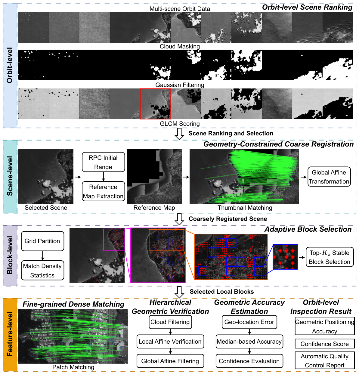
- We propose a geometry-constrained automatic geometric positioning accuracy assessment framework for large-scale satellite imagery, integrating orbit-level scene ranking, geometry-constrained coarse registration, adaptive block selection, dense feature matching, and hierarchical geometric verification into a unified industrial inspection pipeline.
- We introduce a robust geometric registration strategy combining RPC prior constraints, match-density-based adaptive block selection, and hierarchical geometric verification. LoFTR (Sun et al. [23]) is used for dense feature matching, while the adaptive block selection and the hierarchical verification strategy are specifically designed to improve matching reliability under large positioning errors, weak textures, cloud contamination, and temporal appearance variations.
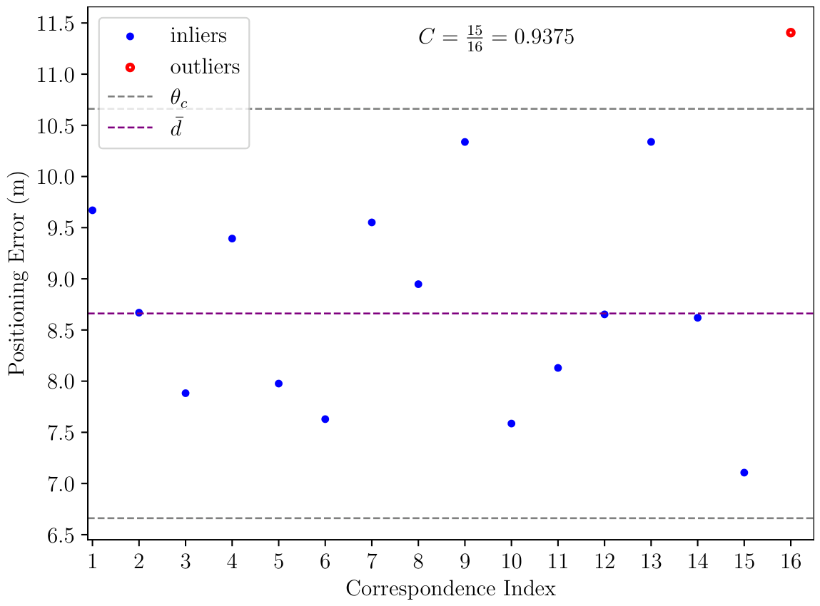
- We introduce a confidence score derived from the dispersion of geolocation positioning residuals, which directly reflects the reliability of the estimated geometric accuracy.
- The proposed framework has been extensively validated using large-scale production data from multiple commercial sub-meter satellite missions and successfully deployed in an operational automatic image production system. The method achieves a median positioning error below 2 m, an Average Precision (AP) improvement of 0.53 over the baseline, and is nearly completely accurate on the evaluated test set when the confidence threshold is above 0.5.
2. Materials and Methods
2.1. System Overview
2.2. Orbit-Level Scene Ranking
2.3. Geometry-Constrained Coarse Registration
2.4. Adaptive Block Selection
2.5. Hierarchical Feature Verification
2.5.1. Cloud Filtering
2.5.2. Local Affine Consistency Verification
2.5.3. Global Geometric Verification
2.6. Geometric Accuracy Estimation
3. Experimental Results
3.1. Quantitative Results
- 1.
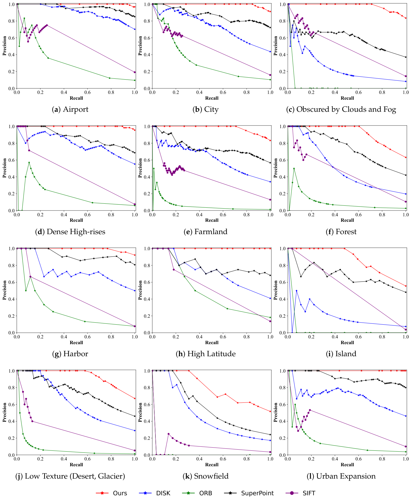
- PR-Curve: For each scene, we calculate positioning accuracy without GCPs, confidence score C, and positioning error , where is the ground truth. An accurate result requires E to be sufficiently small. By adjusting the confidence threshold, we can obtain a series of Precision and Recall values, where Recall is defined as the proportion of scenes in which C exceeds the threshold to the total number of scenes, while Precision is defined as the proportion of recalled scenes where , i.e., two pixels of the reference map. The PR-Curve (Precision–Recall Curve) [34] shows the trade-off between Precision and Recall across different confidence thresholds, enabling the selection of an optimal threshold that balances these metrics based on the specific requirements of the application.
- 2.
- AP: Average Precision (AP) is calculated as the weighted mean of Precision at each threshold in the PR-Curve, with the increase in Recall from the previous threshold serving as the weight. AP represents the area under the PR-Curve (AUC) [35] and summarizes Precision across varying levels of Recall.
- 3.
- : AP does not retain information about specific features of the original PR-Curve, such as the Recall level at which Precision drops from one () and the corresponding confidence threshold . These two parameters are crucial for some application scenarios that have high requirements for accuracy, such as the automated quality assessment of satellite imagery production. Choosing a reasonable confidence threshold can ensure that the detection results are completely accurate and reliable.
3.2. Qualitative Results
3.3. Ablation Studies
3.4. Production System Deployment
4. Discussion
5. Conclusions
6. Patents
Author Contributions
Funding
Data Availability Statement
Acknowledgments
Conflicts of Interest
Abbreviations
| RPC | Rational Polynomial Coefficient |
| GCPs | Ground Control Points |
| GLCM | Gray-Level Co-occurrence Matrix |
| RFM | Rational Function Model |
| DEM | Digital Elevation Model |
| SRTM | Shuttle Radar Topography Mission |
| GT | Ground Truth |
| PR-Curve | Precision–Recall Curve |
| AP | Average Precision |
| SAR | Synthetic Aperture Radar |
References
- Zhu, B.; Zhou, L.; Pu, S.; Fan, J.; Ye, Y. Advances and challenges in multimodal remote sensing image registration. IEEE J. Miniaturization Air Space Syst. 2023, 4, 165–174. [Google Scholar] [CrossRef] [Scilit]
- Zhang, Z.; Zhang, M.; Gong, J.; Hu, X.; Xiong, H.; Zhou, H.; Cao, Z. LuoJiaAI: A cloud-based artificial intelligence platform for remote sensing image interpretation. Geo-Spat. Inf. Sci. 2023, 26, 218–241. [Google Scholar] [CrossRef] [Scilit]
- Lihong, K.; Jing, T.; Bitao, J. Challenges and research on remote sensing satellite application technology in the Giant Constellation Era. Natl. Remote Sens. Bull. 2024, 28, 1658–1666. [Google Scholar] [CrossRef] [Scilit]
- Ge, H.; Li, Y.; Wang, B.; Geng, Y.; Ba, X. Research on automatic quantitative quality inspection method for internal geometric accuracy of remote sensing images. J. Appl. Remote Sens. 2025, 19, 016511. [Google Scholar] [CrossRef] [Scilit]
- Jiang, B.; Dong, X.; Deng, M.; Wan, F.; Wang, T.; Li, X.; Zhang, G.; Cheng, Q.; Lv, S. Geolocation accuracy validation of high-resolution SAR satellite images based on the Xianning validation field. Remote Sens. 2023, 15, 1794. [Google Scholar] [CrossRef] [Scilit]
- Paul, S.; Pati, U.C. A comprehensive review on remote sensing image registration. Int. J. Remote Sens. 2021, 42, 5396–5432. [Google Scholar] [CrossRef] [Scilit]
- Kao, S.C.; Ho, C. Monitoring a process of exponentially distributed characteristics through minimizing the sum of the squared differences. Qual. Quant. 2007, 41, 137–149. [Google Scholar] [CrossRef] [Scilit]
- Wu, B.; Hung, C.F. Innovative correlation coefficient measurement with fuzzy data. Math. Probl. Eng. 2016, 2016, 9094832. [Google Scholar] [CrossRef] [Scilit]
- Hel-Or, Y.; Hel-Or, H.; David, E. Matching by tone mapping: Photometric invariant template matching. IEEE Trans. Pattern Anal. Mach. Intell. 2013, 36, 317–330. [Google Scholar] [CrossRef] [Scilit]
- Ye, Y.; Shan, J.; Hao, S.; Bruzzone, L.; Qin, Y. A local phase based invariant feature for remote sensing image matching. ISPRS J. Photogramm. Remote Sens. 2018, 142, 205–221. [Google Scholar] [CrossRef] [Scilit]
- Li, X.; Ai, W.; Feng, R.; Luo, S. Survey of remote sensing image registration based on deep learning. Natl. Remote Sens. Bull. 2023, 27, 267–284. [Google Scholar] [CrossRef] [Scilit]
- Xiong, Q.; Fang, S.; Peng, Y.; Gong, Y.; Liu, X. Feature matching of multimodal images based on nonlinear diffusion and progressive filtering. IEEE J. Sel. Top. Appl. Earth Obs. Remote Sens. 2022, 15, 7139–7152. [Google Scholar] [CrossRef] [Scilit]
- Lowe, D.G. Distinctive image features from scale-invariant keypoints. Int. J. Comput. Vis. 2004, 60, 91–110. [Google Scholar] [CrossRef] [Scilit]
- Bay, H.; Tuytelaars, T.; Van Gool, L. Surf: Speeded up robust features. In Proceedings of the European Conference on Computer Vision; Springer: Berlin/Heidelberg, Germany, 2006; pp. 404–417. [Google Scholar]
- Rublee, E.; Rabaud, V.; Konolige, K.; Bradski, G. ORB: An efficient alternative to SIFT or SURF. In Proceedings of the 2011 International Conference on Computer Vision; IEEE: New York, NY, USA, 2011; pp. 2564–2571. [Google Scholar]
- Feng, R.; Du, Q.; Luo, H.; Shen, H.; Li, X.; Liu, B. A registration algorithm based on optical flow modification for multi-temporal remote sensing images covering the complex-terrain region. Natl. Remote Sens. Bull. 2021, 25, 630–640. [Google Scholar] [CrossRef] [Scilit]
- DeTone, D.; Malisiewicz, T.; Rabinovich, A. Superpoint: Self-supervised interest point detection and description. In Proceedings of the IEEE Conference on Computer Vision and Pattern Recognition Workshops; IEEE: New York, NY, USA, 2018; pp. 224–236. [Google Scholar]
- Dusmanu, M.; Rocco, I.; Pajdla, T.; Pollefeys, M.; Sivic, J.; Torii, A.; Sattler, T. D2-net: A trainable cnn for joint detection and description of local features. arXiv 2019, arXiv:1905.03561. [Google Scholar]
- Tyszkiewicz, M.; Fua, P.; Trulls, E. Disk: Learning local features with policy gradient. Adv. Neural Inf. Process. Syst. 2020, 33, 14254–14265. [Google Scholar]
- Sarlin, P.E.; DeTone, D.; Malisiewicz, T.; Rabinovich, A. SuperGlue: Learning Feature Matching With Graph Neural Networks. In Proceedings of the IEEE/CVF Conference on Computer Vision and Pattern Recognition (CVPR), Seattle, WA, USA, 13–19 June 2020. [Google Scholar]
- Rocco, I.; Cimpoi, M.; Arandjelović, R.; Torii, A.; Pajdla, T.; Sivic, J. Neighbourhood consensus networks. Adv. Neural Inf. Process. Syst. 2018, 31, 1651–1662. [Google Scholar]
- Li, X.; Han, K.; Li, S.; Prisacariu, V. Dual-resolution correspondence networks. Adv. Neural Inf. Process. Syst. 2020, 33, 17346–17357. [Google Scholar]
- Sun, J.; Shen, Z.; Wang, Y.; Bao, H.; Zhou, X. LoFTR: Detector-Free Local Feature Matching With Transformers. In Proceedings of the IEEE/CVF Conference on Computer Vision and Pattern Recognition (CVPR), Nashville, TN, USA, 20–25 June 2021; IEEE: New York, NY, USA, 2021; pp. 8922–8931. [Google Scholar]
- Shean, D.E.; Alexandrov, O.; Moratto, Z.M.; Smith, B.E.; Joughin, I.R.; Porter, C.; Morin, P. An automated, open-source pipeline for mass production of digital elevation models (DEMs) from very-high-resolution commercial stereo satellite imagery. ISPRS J. Photogramm. Remote Sens. 2016, 116, 101–117. [Google Scholar] [CrossRef] [Scilit]
- Park, R.S.; Scheeres, D.J. Nonlinear semi-analytic methods for trajectory estimation. J. Guid. Control Dyn. 2007, 30, 1668–1676. [Google Scholar] [CrossRef] [Scilit]
- Zhou, X.; Armellin, R.; Qiao, D.; Li, X. Time-varying directional state transition tensor for orbit uncertainty propagation. J. Guid. Control Dyn. 2026, 49, 656–672. [Google Scholar] [CrossRef] [Scilit]
- Valli, M.; Armellin, R.; Di Lizia, P.; Lavagna, M.R. Nonlinear filtering methods for spacecraft navigation based on differential algebra. Acta Astronaut. 2014, 94, 363–374. [Google Scholar] [CrossRef] [Scilit]
- Tao, C.V.; Hu, Y. A comprehensive study of the rational function model for photogrammetric processing. Photogramm. Eng. Remote Sens. 2001, 67, 1347–1358. [Google Scholar]
- Haralick, R.M.; Shanmugam, K.; Dinstein, I.H. Textural features for image classification. IEEE Trans. Syst. Man Cybern. 1973, SMC-3, 610–621. [Google Scholar] [CrossRef] [Scilit]
- Grodecki, J.; Dial, G. Block adjustment of high-resolution satellite images described by rational polynomials. Photogramm. Eng. Remote Sens. 2003, 69, 59–68. [Google Scholar] [CrossRef] [Scilit]
- Fraser, C.S.; Hanley, H.B. Bias-compensated RPCs for sensor orientation of high-resolution satellite imagery. Photogramm. Eng. Remote Sens. 2005, 71, 909–915. [Google Scholar] [CrossRef] [Scilit]
- Fraser, C.S.; Dial, G.; Grodecki, J. Sensor orientation via RPCs. ISPRS J. Photogramm. Remote Sens. 2006, 60, 182–194. [Google Scholar] [CrossRef] [Scilit]
- Zhang, G.; Zhu, X. A study of the RPC model of TerraSAR-X and COSMO-SkyMed SAR imagery. Remote Sens. Spat. Inf. Sci. 2008, 36, 321–324. [Google Scholar]
- Manning, C.; Schutze, H. Foundations of Statistical Natural Language Processing; MIT Press: Cambridge, MA, USA, 1999. [Google Scholar]
- Davis, J.; Goadrich, M. The relationship between Precision-Recall and ROC curves. In Proceedings of the 23rd International Conference on Machine Learning; Association for Computing Machinery: New York, NY, USA, 2006; pp. 233–240. [Google Scholar]
- Lindenberger, P.; Sarlin, P.E.; Pollefeys, M. Lightglue: Local feature matching at light speed. In Proceedings of the IEEE/CVF International Conference on Computer Vision; IEEE: New York, NY, USA, 2023; pp. 17581–17592. [Google Scholar]



| Symbol | Value | Function |
|---|---|---|
| 5 | Gaussian filter kernel size | |
| 0.4 | Contrast weighting coefficient | |
| 0.6 | Entropy weighting coefficient | |
| 1024 × 1024 | Thumbnail size | |
| 16 | Number of fine-grained matching grids | |
| 5 | Local affine threshold (pixels) | |
| 15 | Global affine threshold (pixels) | |
| 5 | Geometric error threshold (m) |
| AT | CY | OCF | DH | FD | FT | HR | HL | ID | LT | SD | UE | ||
|---|---|---|---|---|---|---|---|---|---|---|---|---|---|
| INFO | GF03D | 41 | 51 | 43 | 22 | 78 | 30 | 15 | 0 | 6 | 39 | 11 | 42 |
| KF02B | 48 | 43 | 45 | 35 | 54 | 36 | 5 | 19 | 17 | 32 | 13 | 36 | |
| GF07 | 5 | 32 | 9 | 10 | 23 | 10 | 6 | 3 | 4 | 5 | 5 | 2 | |
| Total | 94 | 126 | 97 | 67 | 155 | 76 | 26 | 22 | 27 | 76 | 29 | 80 | |
| AP ↑ | SIFT | 0.535 | 0.4769 | 0.4912 | 0.4531 | 0.3794 | 0.4511 | 0.4379 | 0.5387 | 0.5364 | 0.2868 | 0.0999 | 0.3522 |
| ±0 | ±0 | ±0 | ±0 | ±0 | ±0 | ±0 | ±0 | ±0 | ±0 | ±0 | ±0 | ||
| ORB | 0.313 | 0.3294 | 0.0309 | 0.174 | 0.058 | 0.0966 | 0.2627 | 0.4967 | 0.037 | 0.0748 | 0.0172 | 0.1502 | |
| ±0 | ±0 | ±0 | ±0 | ±0 | ±0 | ±0 | ±0 | ±0 | ±0 | ±0 | ±0 | ||
| SuperP | 0.9641 | 0.8714 | 0.589 | 0.8754 | 0.7508 | 0.7475 | 0.9192 | 0.798 | 0.6792 | 0.752 | 0.5717 | 0.9201 | |
| ±0 | ±0 | ±0 | ±0 | ±0 | ±0 | ±0 | ±0 | ±0 | ±0 | ±0 | ±0 | ||
| DISK | 0.9089 | 0.7365 | 0.2509 | 0.7883 | 0.6179 | 0.505 | 0.7258 | 0.7164 | 0.1935 | 0.6305 | 0.4703 | 0.6907 | |
| ±0 | ±0 | ±0 | ±0 | ±0 | ±0 | ±0 | ±0 | ±0 | ±0 | ±0 | ±0 | ||
| Ours | 0.9988 | 0.9933 | 0.9782 | 0.9937 | 0.958 | 0.9133 | 0.9949 | 1 | 0.8736 | 0.9337 | 0.7942 | 1 | |
| ±0 | ±0.0001 | ±0 | ±0.0059 | ±0.0264 | ±0.0076 | ±0.0051 | ±0 | ±0 | ±0 | ±0 | ±0 | ||
| RP100 ↑ | SIFT | 0 | 0 | 0 | 0.0746 | 0 | 0.0395 | 0.0769 | 0.1364 | 0.037 | 0 | 0 | 0 |
| ORB | 0.0106 | 0.0397 | 0 | 0 | 0 | 0 | 0.0385 | 0.1364 | 0 | 0.0132 | 0 | 0.0125 | |
| SuperP | 0.3404 | 0.0952 | 0 | 0.2388 | 0.0323 | 0.1447 | 0.2692 | 0.1364 | 0.037 | 0.1316 | 0.1724 | 0.2625 | |
| DISK | 0.2021 | 0 | 0.0103 | 0 | 0.0323 | 0.0921 | 0.1538 | 0.1818 | 0 | 0.1974 | 0.1379 | 0.0375 | |
| Ours | 0.9362 | 0.8492 | 0.7113 | 0.8955 | 0.7097 | 0.6053 | 0.7692 | 1 | 0.4815 | 0.5789 | 0.3103 | 1 | |
| CP100 ↓ | SIFT | / | / | / | 0.8649 | / | 1 | 0.9432 | 0.8788 | 0.775 | / | / | / |
| ORB | 0.625 | 0.6875 | / | / | / | / | 0.9375 | 0.5 | / | 0.9375 | / | 0.75 | |
| SuperP | 0.9375 | 1 | / | 0.9286 | 0.9333 | 0.6875 | 0.875 | 0.875 | 0.9375 | 0.8333 | 0.375 | 0.8667 | |
| DISK | 1 | / | 0.9375 | / | 0.9167 | 0.5385 | 0.875 | 0.6667 | / | 0.75 | 0.5 | 1 | |
| Ours | 0.5 | 0.5 | 0.5 | 0.4375 | 0.5 | 0.4375 | 0.5 | 0.1875 | 0.5 | 0.5 | 0.5 | 0.25 |
| Poor GEO | Changes | Clouds | Degradation | |
|---|---|---|---|---|
| SIFT | / | / | / | / |
| Ours_wo_CR | / | 12.27 (0.56) | 21.87 (0.31) | 45.11 (1) |
| Ours_wo_ABS | 7726.62 (0.75) | 12.24 (0.69) | 26.33 (0.06) | 45.01 (1) |
| Ours | 7727.36 (1) | 12.64 (0.9375) | 19.36 (0.875) | 45.33 (1) |
| Quality Grade | Total | Number of Detections | Recall |
|---|---|---|---|
| High | 41,903 | 40,535 | 97% |
| Low | 26,623 | 25,609 | 96% |
Disclaimer/Publisher’s Note: The statements, opinions and data contained in all publications are solely those of the individual author(s) and contributor(s) and not of MDPI and/or the editor(s). MDPI and/or the editor(s) disclaim responsibility for any injury to people or property resulting from any ideas, methods, instructions or products referred to in the content. |
© 2026 by the authors. Licensee MDPI, Basel, Switzerland. This article is an open access article distributed under the terms and conditions of the Creative Commons Attribution (CC BY) license.
Share and Cite
Cui, J.; Wang, W.; Fan, L.; Yu, S.; Zhong, X.; Jia, H.; Li, Z. A Geometry-Constrained Framework for Automatic Geometric Positioning Accuracy Assessment of Large-Scale Satellite Imagery. Remote Sens. 2026, 18, 3055. https://doi.org/10.3390/rs18173055
Cui J, Wang W, Fan L, Yu S, Zhong X, Jia H, Li Z. A Geometry-Constrained Framework for Automatic Geometric Positioning Accuracy Assessment of Large-Scale Satellite Imagery. Remote Sensing. 2026; 18(17):3055. https://doi.org/10.3390/rs18173055
Chicago/Turabian StyleCui, Jiaming, Weibin Wang, Liming Fan, Shuhai Yu, Xing Zhong, Hongguang Jia, and Zhenjiang Li. 2026. "A Geometry-Constrained Framework for Automatic Geometric Positioning Accuracy Assessment of Large-Scale Satellite Imagery" Remote Sensing 18, no. 17: 3055. https://doi.org/10.3390/rs18173055
APA StyleCui, J., Wang, W., Fan, L., Yu, S., Zhong, X., Jia, H., & Li, Z. (2026). A Geometry-Constrained Framework for Automatic Geometric Positioning Accuracy Assessment of Large-Scale Satellite Imagery. Remote Sensing, 18(17), 3055. https://doi.org/10.3390/rs18173055