Review

A Review of the Research Status and Prospects of Regional Crop Yield Simulations

1
State Key Laboratory of Efficient Utilization of Arid and Semi-arid Arable Land in Northern China, The Institute of Agricultural Resources and Regional Planning, Chinese Academy of Agricultural Sciences, Beijing 100081, China
2
School of Information and Communication Engineering, North University of China, Taiyuan 030051, China
*
Author to whom correspondence should be addressed.
These authors contributed equally to this work.
Agronomy 2024, 14(7), 1397; https://doi.org/10.3390/agronomy14071397
Submission received: 26 May 2024 / Revised: 25 June 2024 / Accepted: 25 June 2024 / Published: 27 June 2024
(This article belongs to the Section Agricultural Biosystem and Biological Engineering)

Abstract

:
To better promote the research and development of regional crop yield simulations, we review related research on regional crop yield simulations over the past ten years, summarize the research progress on regional crop yield simulations at home and abroad from the three aspects of crop growth models, remote sensing technology, and data assimilation technology, and propose three future development directions for regional crop yield simulations: (1) Based on the agronomic mechanism of crop yield estimation, it is necessary to fully consider crop growth characteristics and yield formation mechanisms. (2) With respect to the remote sensing mechanism of crop yield estimation, we can consider combining radar stereo lateral view measurement technology to determine crop characteristics and remote sensing information. (3) From the perspective of combining agronomy and remote sensing, the crop yield spatiotemporal simulation assimilation algorithm should be optimized, and the yield simulation unit should be extended. It is expected that these considerations can provide new ideas for regional crop yield simulations with high accuracy, a large scale, and full coverage.

1. Introduction

Crop yield simulation has always been an important research focus in the agricultural production field. Timely, accurate, and large-scale monitoring of regional crop yield is essential for guiding agricultural production, ensuring food security, and maintaining sustainable agricultural development [1,2,3].
To better promote the research and development of regional crop yield simulations, we reviewed relevant studies of regional crop yield simulations over the last ten years. Based on methodological principles and technical bases, regional crop yield simulation models can be classified into three categories: crop growth models, yield estimations based on remote sensing techniques, and yield estimations based on data assimilation techniques. The crop growth model adopts mathematical model methods to simulate crop yield formation processes under quantitative and dynamic states. Based on crop variety characteristics, meteorological and soil conditions, field management, and other parameters, the crop model quantitatively describes the comprehensive effects of light, temperature, water, fertilizer, and other factors on crop growth and development and accurately simulates the dynamic process of crop yield formation at the single-point scale [4,5,6]. Crop growth models can better simulate crop growth and development at the single-point scale. However, when crop yield simulations are expanded from a single point to the regional scale, the increase in spatial scale will pose difficulties for the parameter acquisition and regionalization of crop growth models [7]. In the 1970s, the rapid development of satellite remote sensing technology brought new methods for regional crop yield simulation. Crop yield simulations based on remote sensing technology use crop spectral features detected by satellite sensors to indirectly estimate crop yields by determining the relationships between crop spectral features and crop parameters [8]. Tang et al. [9] developed a new model for predicting oilseed rape yield based on high-resolution remote sensing images. The prediction error of the algorithm was less than 5.5%, indicating that this model could effectively predict rapeseed yield in a large area. With the development of computer technology, scholars have combined vegetation indices obtained from remote sensing data with deep learning, the Google Earth Engine, and other technologies to predict soybean yields [10,11], and the correlation coefficient of prediction accuracy reached 0.88. Satellite remote sensing technology can compensate for the deficiency of crop growth models in regional applications and provide technical support for realizing crop yield simulations at the regional scale [12,13,14]. However, crop yield simulations based on remote sensing technology lack information on agronomic mechanisms and have limitations in the analysis of yield-limiting factors such as nutrients and water [15]. Based on the advantages and disadvantages of the above two regional crop yield estimation methods, researchers have begun to consider using data assimilation technology to combine crop growth models and remote sensing observation data, organically combining the advantages of single-point simulation with regional information, improving crop growth monitoring and yield estimation capabilities, and realizing the spatiotemporal expansion of remote sensing inversion and crop model simulation [16,17,18]. Overall, the three models complement each other and have their own advantages. The regional crop yield simulation model gradually improved, and the simulation accuracy continuously increased.
In recent years, researchers have carried out numerous regional crop yield estimation studies based on crop growth models [19,20], remote sensing technology [21,22], and data assimilation technology [23,24] and have achieved promising results. For the purpose of systematically exploring the development trend and evolution characteristics of regional crop yield simulation models, this paper reviewed the research on regional crop yield simulations over the last ten years and summarized the research progress of each of the three models, including the crop type, remote sensing data source selection, and model method application. In this paper, the future development trend of regional crop yield simulations is discussed to provide a new idea for high-precision, large-scale, and full-coverage regional crop yield simulations.

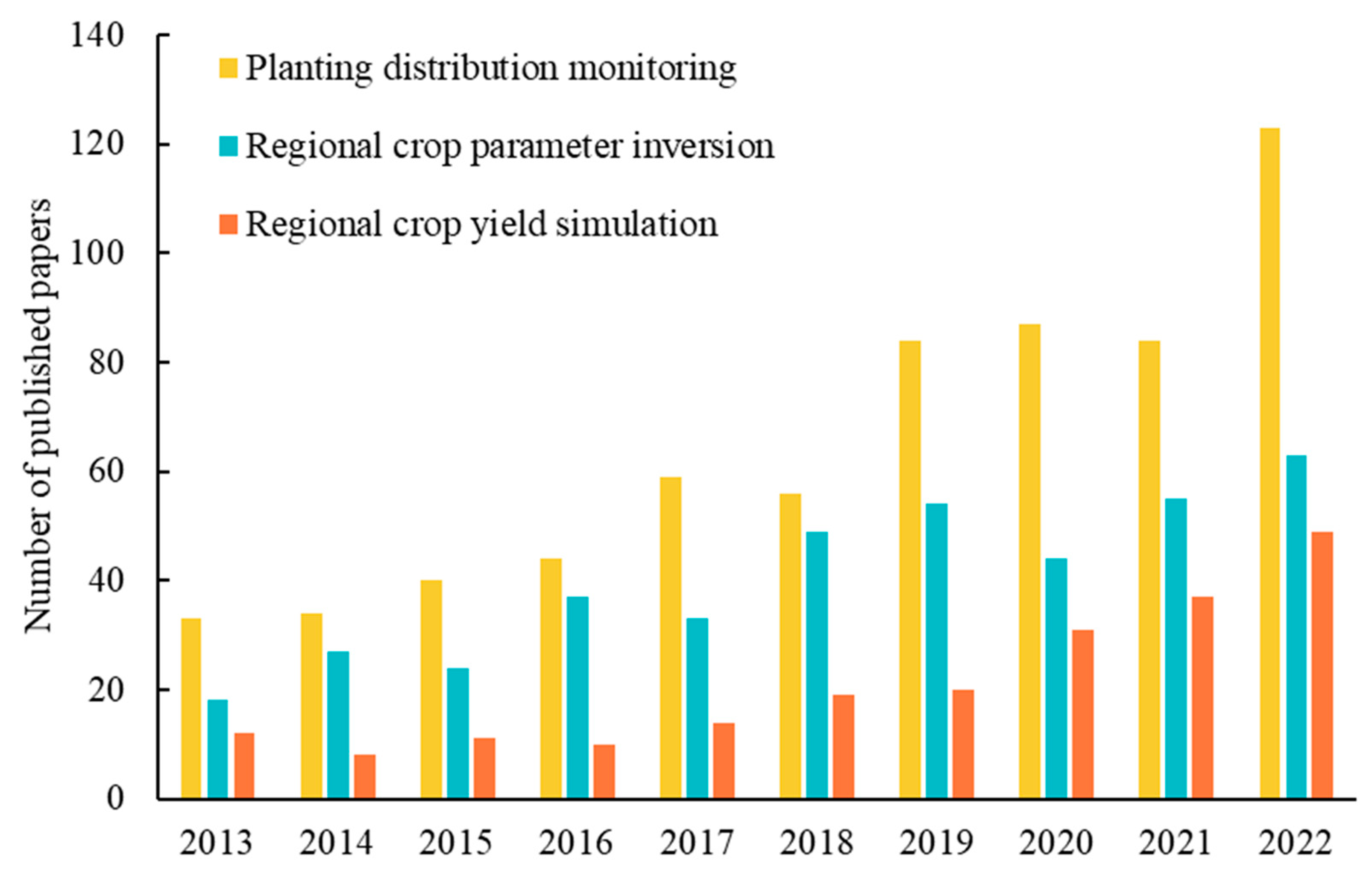
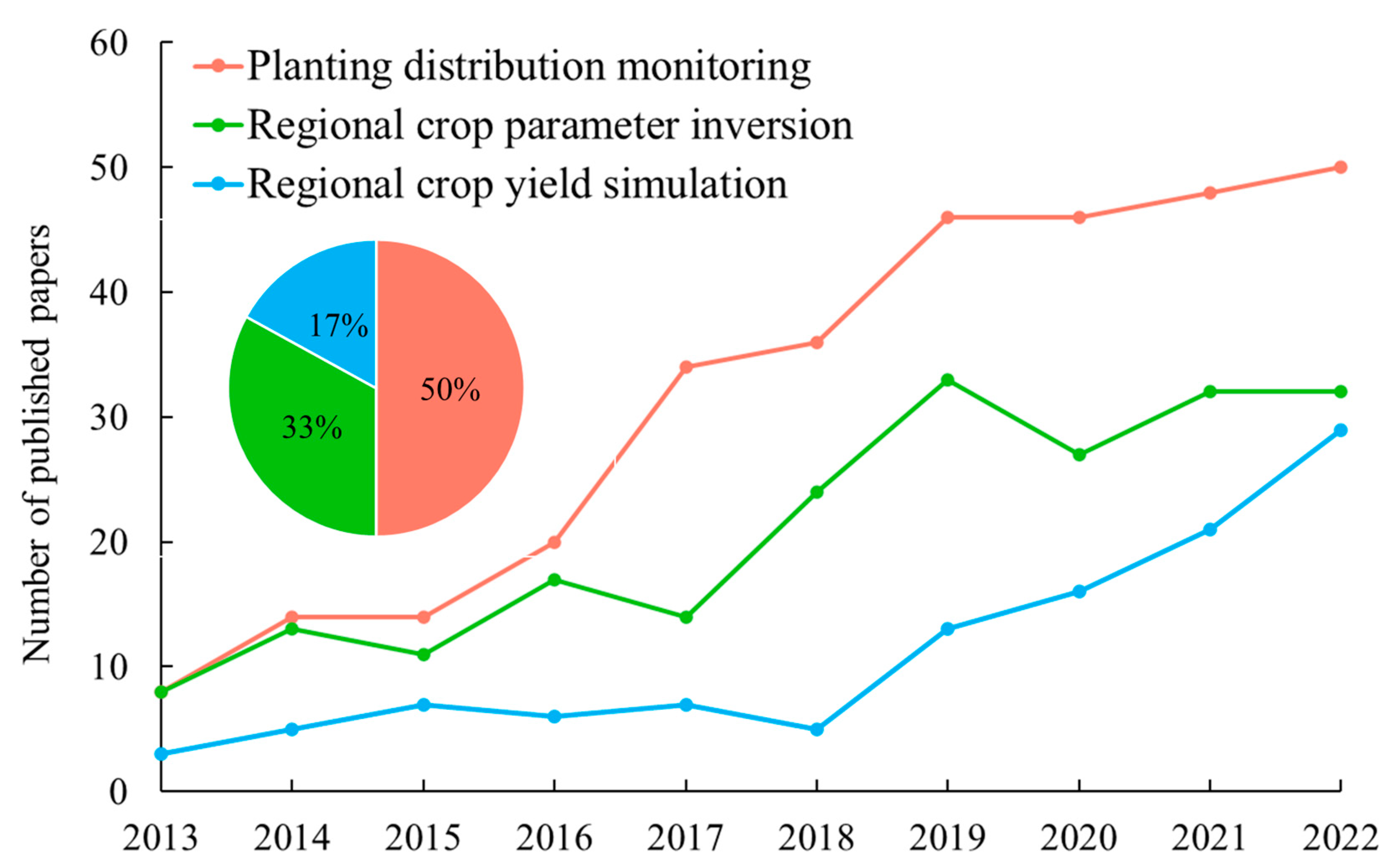
2. Bibliometrics of Regional Crop Yield Simulation

Using the Web of Science (https://webofscience.clarivate.cn/) and China National Knowledge Infrastructure (CNKI) databases (https://www.cnki.net/), we searched for relevant studies on crop remote sensing monitoring from 2013 to 2022, and the search keywords included agricultural monitoring, crop yield simulation, crop planting distribution, crop parameter inversion, remote sensing, and other keywords. Figure 1 illustrates our literature search and screening process. This study was based on the criteria of the PRISMA statement for literature screening [25]. The inclusion criteria were based on high relevance to the keywords, and the abstract and full text were also relevant to the topic. The exclusion criteria were irrelevant to the topic, non-Chinese and English literature, and literature for which full texts could not be found. Figure 2 shows the search terms and their performance, depicting the development of each field. Relevant studies on plant distribution were retrieved through “agricultural monitoring, remote sensing, crops, and planting area distribution”; crop parameter inversion was retrieved through keywords such as “remote sensing, crops, and parameter inversion”; and regional crop yield simulation was retrieved through “remote sensing, monitoring, crops, regions, and yield simulation”. However, this search method is crude and may contain some papers that are less relevant to the topic. Therefore, through further screening one by one, a total of 639 relevant papers were successfully identified, and all showed an increasing trend yearly (Figure 3). Among them, crop planting distribution monitoring and regional crop parameter inversion were the major research directions, accounting for approximately 84%; studies on regional crop yield simulation were relatively rare, accounting for only 16% (Figure 3). The above studies were mainly published in mainstream remote sensing journals such as Remote Sensing, Remote Sensing of Environment, Field Crops Research, and Agricultural Water Management.
We further analyzed the reasons for the low number of papers published on regional crop yield simulations. Regional crop yield estimation methods mostly include crop growth models, remote sensing technology, and data assimilation methods, and there are difficulties in the application of each method. First, when crop growth models are applied to regional crop yield simulations, the model parameters need to be corrected, a process also known as the “localization” of the crop growth model. When the number of parameters in the crop growth model is large, the “localization” process of the model is complex and involves the agronomic mechanism of the crop, which makes it difficult to apply to regional yield simulations [26,27]. Second, remote sensing technology cannot directly determine crop yield, and a relationship between remote sensing features and crop parameters must be established to indirectly simulate crop yield. The remote sensing mechanism is involved in crop parameter inversion. There are shortcomings in the ability to perceive crop parameters [28,29,30,31]. Finally, crop yield estimation-based data assimilation is a cutting-edge technology that combines the advantages of single-point crop growth simulation and regional remote sensing, involving mechanisms of agronomy and remote sensing. On the other hand, when the assimilation technique is used for regional yield estimation, the optimal assimilation unit should be selected. The size of the assimilation unit is related to the computational pressure [32]. Therefore, regional crop yield simulations have certain complexities in terms of both yield estimation theory and yield estimation system construction. Moreover, crop growth is cyclical, and the output of the estimated yield also has a certain period. Therefore, the number of papers published in current regional crop yield estimation studies is relatively small. However, from the perspective of research significance, crop yield information is the goal of regional crop monitoring, and it is very important for national food policy formulation, price macrocontrol, and food trade. Although the number of papers published in this study area was relatively low, research on regional crop yield simulations has great potential for the future.

3. Research Progress on Regional Crop Yield Simulations

Crop growth models, remote sensing technology, and data assimilation technology are the major methods used in regional crop yield simulation research. Crop growth models can simulate the process of crop growth and yield formation under quantitative and dynamic conditions [33]. However, when crop growth models are applied to regional yield simulations, it is difficult to obtain the key parameters of soil and crops at the regional scale, which hinders the application of crop growth models in large-scale crop growth monitoring and yield simulations [7,34,35]. Satellite remote sensing has the advantages of being fast, macro- and dynamic, and can obtain regional surface information in a timely manner and monitor the macro-growth of crops [14]. Data assimilation technology can organically combine the advantages of remote sensing information and crop growth models and is one of the major methods for simulating regional yields. Using data assimilation technology can improve the accuracy of regional crop yield simulations [36,37,38]. Therefore, we summarized the research progress on regional crop yield simulations from three perspectives: crop growth models, remote sensing technology, and data assimilation technology.

3.1. Crop Yield Simulation Based on the Crop Growth Model

Crop yield simulation based on a crop growth model adopts a mathematical model method to simulate crop yield formation and other processes under quantitative and dynamic conditions. Such models typically consider several key elements, including limiting factors that determine crop growth (such as temperature, moisture, and light) and stress indicators (such as physiological responses to stressful conditions). Furthermore, by describing the equations of biomass accumulation and distribution, the model considers biological processes, such as photosynthesis, respiration, and nutrient absorption, to comprehensively simulate the life cycle of crops from sowing to harvesting. The leaf area index (LAI) is important in this process because it reflects vegetation cover and photosynthesis, which importantly impact crop growth and yield. By considering these mechanisms and processes, crop growth models can be excellent tools for studying crop growth and accurately predicting crop responses to environmental conditions. The comprehensive effects of light, temperature, water, fertilizer, and other factors on crop growth and development are quantitatively described according to the characteristics of crop varieties, meteorological and soil conditions, field management, and other parameters. The dynamic processes of crop growth, development, and yield formation can be accurately simulated [39,40].
In the 1960s, researchers in the Netherlands and the United States began to study crop growth simulations based on computer technology, which is also a prototype of crop models. De Wit first studied the photosynthesis of plant canopy leaves and simulated the photosynthetic rate of canopy leaves based on computer technology [41]. Duncan et al. established the SIMAIZ model on the basis of de Wit’s theory [42]. Since then, crop growth simulation technology has developed rapidly, forming a series of crop growth models used in crop growth monitoring and yield simulation research. After decades of development, crop yield simulation research based on crop growth models has achieved more results. At present, the most influential crop growth models are the European WOFOST model [43,44], the STICS model [45,46], the AquaCrop model [47,48,49], the American DSSAT model [50,51], the EPIC model [52,53], the APEX model [54,55], and the Australian APSIM model [56,57].
By sorting and analyzing relevant studies from the past ten years, we evaluated the models, crop types, and study area distributions used in regional crop yield simulation research based on crop growth models. The relevant statistics are shown in Figure 4.
Figure 4a shows that crop growth models can be divided into two major categories: special models and general models. The WOFOST crop model in the Netherlands and the DSSAT model in the United States are the two most commonly used crop growth models. European crop growth models, represented by the WOFOST crop model, are characterized by their strong interpretability, mechanization, and versatility. Researchers have simulated the yields of maize, wheat, and other crops in Europe based on the European crop model [58,59,60]. When the European crop model is applied to crop yield simulations in countries or regions outside Europe, it is necessary to calibrate the crop parameters to complete the “localization” model to make the model suitable for crop yield simulations in the study area [44,61,62]. The “localization” of the crop model is mainly used to correct the parameters of the crop growth model that are difficult to obtain accurately and greatly influence crop growth. Among them, crop parameters are closely related to crop growth and are the main parameters for the “localized” correction of crop models. The European crop model considers the commonalities of different crops and simplifies and ignores some relatively minor crop growth and developmental processes; thus, the model’s calibration workload is relatively small [63]. The American EPIC model is a generic model similar to the WOFOST model. Through the “localization” of the model, the EPIC model has been applied to the yield simulation of major crops in other countries or regions outside the United States [53,64]. The American DSSAT series model, the APEX model, and the Australian APSIM series model are composed of a series of crop growth models for specific crop types. They are specialized crop growth models with strong specificity, and more attention has been given to practical applications [65,66,67]. However, the specialized model can simulate a limited variety of crops, and when the model is promoted in other countries or regions, due to the large number of input parameters, the workload of “localization” of the model is large [26,27].
Figure 4b shows the profiles of different crop studies and the use of crop yield models corresponding to different crops. At present, research on yield estimation based on crop growth models has focused mainly on wheat [60,68,69], corn [70,71,72,73], and rice [64,74,75], and there is less research on soybean [57], rape [76], sunflower [45], and other crops. The two dominant models, the WOFOST and DSSAT models, are mostly used for maize, wheat, and rice, while other crops are less commonly used or are yet to be studied.
Figure 4c shows the study area distribution of the regional crop yield simulation based on the crop growth model. The color shading in Figure 4c indicates the number of papers included in the yield simulation study in this region. Crop yield simulation studies based on crop growth models are widely distributed across Europe [45,59,77], Asia [78,79,80], Africa [53,73], and the Americas [19,52]. It is especially concentrated in major grain-producing countries such as China [81,82], the United States [50,66], and Canada [46,51].
Crop growth models not only simulate crop yield but also analyze the influence of crop yield-limiting factors, such as nutrients and water, on crop growth, development, and yield formation. Maniruzzaman et al. used the AquaCrop model to simulate rice crop growth under different water irrigation conditions and studied the influence of water on yield [83]. Yang et al. used the DSSAT crop model to study the effect of soil moisture on crop yield, and their results showed that an increase in initial soil moisture could increase the yield of cereal crops [84]. However, crop growth models have some shortcomings in terms of their crop yield simulations. First, when the research scale of crop yield simulation based on a crop growth model is extended to the regional scale, the increase in spatial scale will increase the difficulty of parameter acquisition and regionalization in the crop growth model, and the “localization” of the model is difficult. At present, the crop growth models used in crop yield simulations are mostly general crop growth models dominated by the WOFOST model and specialized crop growth models dominated by the DSSAT model. The general model has strong adaptability to the study area and crops, and the number of calibration parameters is low. However, the general model simplifies and ignores some factors that have less impact on crop growth and developmental processes. For some crops, the simulation accuracy of the general model may be low. There are more input parameters for the special model, and the model localization workload is large. Moreover, it is difficult to correct the parameters of the special model, which brings challenges to yield research across regions and crops. Second, there are few studies on the yield estimation of crops such as soybean, rape, and sunflower based on crop growth models. At present, most crop growth models are based on bulk staple crops such as wheat, corn, and rice, so they are more suitable for these crops. Compared with wheat, corn, rice, and other crops, soybean, rape and other crops are more complex in terms of both plant morphology and crop yield accumulation processes. The analysis of the crop growth process and the research and development of crop growth models need to be strengthened.

3.2. Crop Yield Simulation Based on Remote Sensing Technology

Traditional crop planting and yield information acquisition occur mainly through ground surveys, which are inefficient, cannot obtain real-time and dynamic crop monitoring results, and consume considerable manpower and material resources. Since the 1970s, large-scale yield estimation technology based on remote sensing has developed rapidly. Satellite remote sensing has been widely used in the research and application of regional crop yield monitoring due to its advantages of wide coverage and timely and rapid information acquisition. The crop yield simulation method based on remote sensing technology uses the optical spectral characteristics of crops, records ground and crop information through satellite sensors, and estimates crop yield by determining the correlation between the satellite band and crop yield [85].
By collating and analyzing relevant research over the past ten years, we collected the modeling methods, remote sensing data and characteristics, and crop phenology used in regional crop yield simulations based on remote sensing technology. The relevant statistics are shown in Figure 5.
The modeling methods used for crop yield estimation via remote sensing mostly include parametric methods and machine learning methods. Over the last ten years, the parametric method has been the main method of remote sensing modeling (Figure 5a). The parametric methods include the linear regression (LR) method and multiple linear regression methods, which are mainly based on remote sensing bands or remote sensing vegetation indices to establish an empirical regression relationship with yield [86,87,88]. The modeling method of the parametric method is simple, but the model relies too much on ground-measured data, so the model has poor mobility and robustness [89]. Machine learning models can be used to identify data features and obtain complex relationships between driving variables [88,89]. Machine learning methods can explore relationships between multiple variables. The results are more accurate than those of parametric models. Machine learning models used in yield simulation include support vector regression (SVR), artificial neural networks (ANNs), and random forest (RF) [88,89,90].
The major remote sensing data used in crop yield estimation are Landsat, MODIS, Sentinel, HJ-1A/1B, and other optical remote sensing data (Figure 5b), accounting for up to 91%. The remote sensing data used in early research were mostly MODIS [90,91], SPOT-VGT [89], and other low spatial resolution data. In the later period, with the development of remote sensing technology and improvements in the spatial resolution of remote sensing data, the remote sensing data used were mainly Landsat series with medium spatial resolution [22,92,93,94], HJ-1A/B with medium and high spatial resolution [95], and Sentinel with high resolution [96,97]. The modeling bands mostly focus on the visible and near-infrared bands [98,99,100]. Remote sensing sensors cannot directly sense crop yield. The yield estimation method based on remote sensing technology needs to use the remote sensing band or the vegetation index calculated through the band to invert canopy or crop parameters that are closely related to crop yield to obtain the relationship between remote sensing characteristics and crop parameters to estimate crop yield [31]. Among them, the normalized difference vegetation index (NDVI) and enhanced vegetation index [101] are the most widely used remote sensing vegetation indices; the LAI and aboveground biomass are the most widely used crop parameters [30,89,92,102]. These methods provide effective information about crop growth and photosynthesis accumulation. By monitoring these parameters, key crop spatial information can be obtained to improve the accuracy of crop yield estimations. In addition, crop yield estimation studies by remote sensing have focused more on crop phenology. The yield estimation models based on different phenological periods of crops differ greatly in terms of the accuracy and effect of yield estimation [103]. Wheat yield estimation by remote sensing is mainly based on the wheat flowering period to establish a yield estimation model [95,104,105]. Maize yield estimation models based on remote sensing are mostly constructed for growth stages such as seedling emergence and grain filling [94,106].
Satellite remote sensing has the advantages of being fast, macro- and dynamic, and can monitor the macroconditions of crops and reflect the comprehensive effect of environmental factors on crops [107,108,109,110]. However, remote sensing technology has shortcomings in crop yield simulations. First, crop yield simulations based on either parametric methods or machine learning methods lack agricultural mechanisms and cannot simulate the continuous growth and developmental process of crops with changes in the growth period. Moreover, there are limitations in the analysis of the influence of yield-limiting factors such as nutrients and water on yield simulation accuracy [15]. Second, crop yield estimation studies based on remote sensing mainly use optical remote sensing images, and optical remote sensing data have shortcomings in terms of the ability to perceive crop parameters and the continuity of spatial coverage. The canopies of oilseed rape, soybean, and other crops contain non-leaf organs such as siliques and pods in a specific growth period, and the shape, arrangement, and distribution of siliques and pods are different from those of crop leaves. The reflection characteristics obtained only by optical remote sensing can hardly support remote sensing inversion of these organ parameters. Fan et al. simulated regional rapeseed yield based on a remote sensing vegetation index. Their results showed that the LAI at the flowering stage of rapeseed had potential for the early prediction of rapeseed yield, but the accuracy of yield prediction decreased due to the influence of canola siliques in the later flowering stage [111]. Gong et al. reported in a study of rapeseed yield estimation that the effect of siliques on yield simulation should be considered when simulating rapeseed yield based on remote sensing technology [112]. Ma et al. estimated biomass based on canopy height spectral data of rape at different growth stages, and their results showed that rape silique seriously interfered with hyperspectral data and thus affected the accuracy of biomass simulation [113]. In addition, it may be difficult to obtain sufficient optical remote sensing data in some crop-growing areas affected by meteorological conditions.

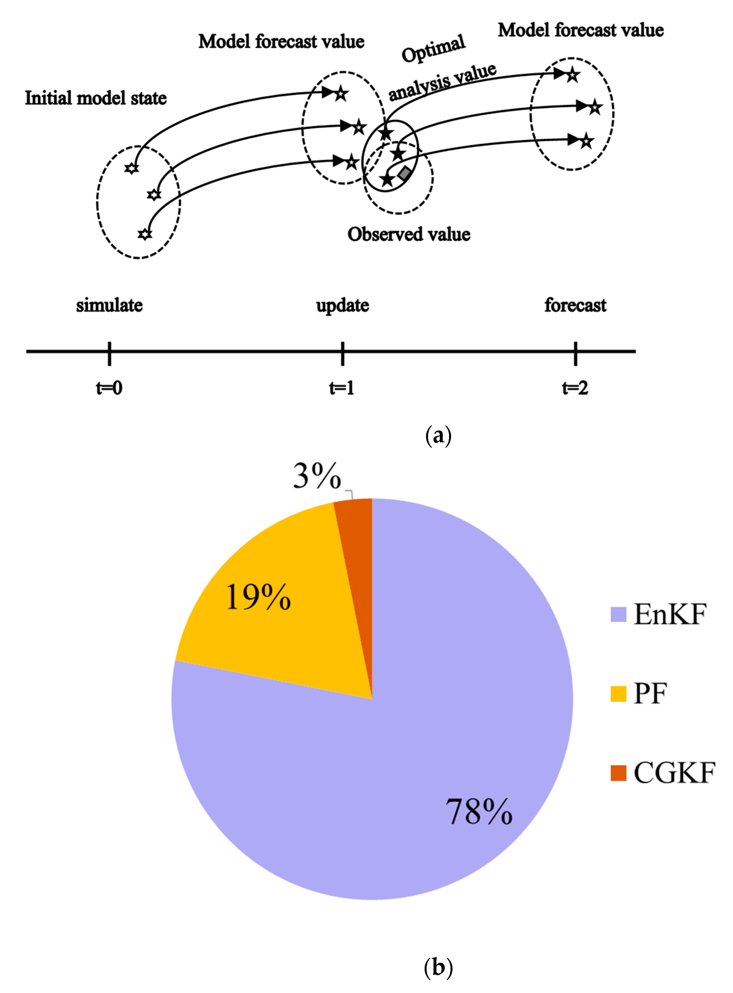
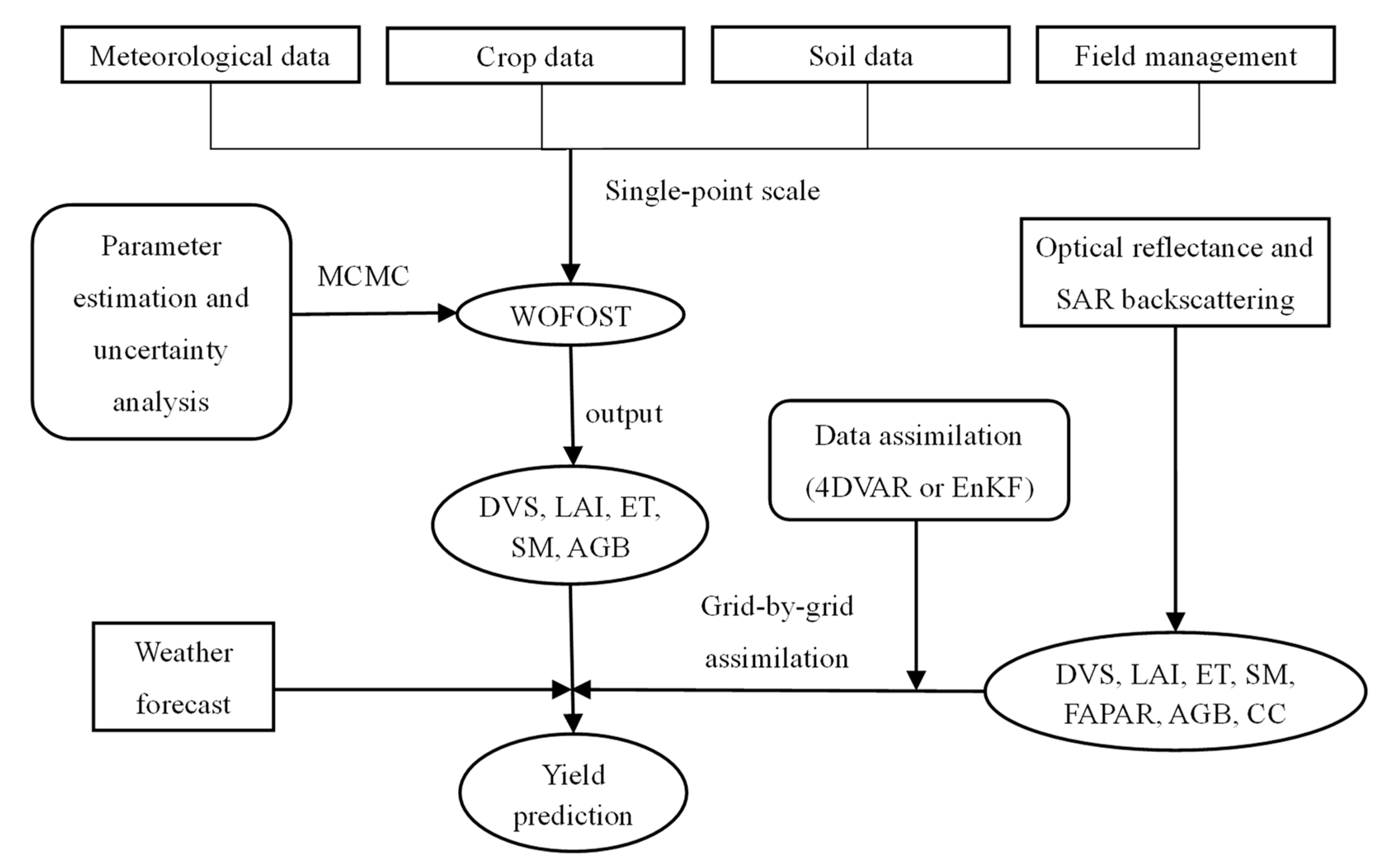
3.3. Crop Yield Simulation Based on Data Assimilation Technology

According to Section 3.1 and Section 3.2, crop yield simulations based on crop growth models and remote sensing technology have their own advantages and disadvantages. The data assimilation yields are estimated mainly by integrating remote sensing observation data and model simulations. Assimilation technology is used to calibrate model parameters to better match the observation data. In addition, remote sensing data provide a wide range of crop information that can be used for model correction. Data assimilation technology can combine the advantages of regional remote sensing and crop model simulation and is an important means to supplement remote sensing observations and improve the accuracy of regional crop yield simulations. Wu et al. compared the simulation accuracy of wheat yield before and after the application of data assimilation technology in their study and verified that data assimilation technology can effectively improve the simulation accuracy of crop yield [114]. Pazhanivelan et al. simulated regional rice yield based on remote sensing technology and data assimilation technology, and their research results showed that data assimilation technology could improve the accuracy of crop yield estimation by coupling remote sensing information with crop models [115]. The yield estimation system, which is mainly based on data assimilation, includes three parts: a data assimilation algorithm, a crop growth model, and remote sensing observation data. Figure 6 shows a typical crop yield estimation system based on data assimilation.
Figure 6 shows the WOFOST crop growth model, which includes meteorological data, crop data, soil data, and other observational data at the field scale. After localized correction, the growth and developmental processes of crops and indices such as the LAI, SM, biomass, and yield can be accurately simulated. The MCMC method is used to study the posterior distribution of the parameters and can quantify the posterior expectation and the uncertainty of the model parameters under the observed conditions. Optical and radar remote sensing can be used to quantitatively reconstruct important crop parameters, such as DVS, LAI, ET, SM, FAPAR, and AGB. By introducing the remote sensing parameters of a large region and using data assimilation technology, the state variables were optimized in each grid in the region, or a set of model parameters was optimized after several iterations to optimize the regional crop model and improve the simulation effect of the regional crop yield per unit area.
By sorting and analyzing relevant studies from the past ten years, we evaluated the assimilation algorithm, crop growth model, remote sensing observation data, and assimilation units used in regional crop yield simulations based on data assimilation technology. The relevant statistics are shown in Figure 7 and Figure 8.
Among the assimilation algorithms used in regional crop yield simulation studies based on data assimilation technology, parameter optimization algorithms based on cost functions and ensemble filtering algorithms based on estimation theory are the two most widely used assimilation algorithms.
The parameter optimization method is mainly used to adjust the parameters or initial conditions that are closely related to yield and difficult to obtain in crop growth models through multiple iterations to minimize the difference between remote sensing observed values and model simulated values to optimize the model [117,118]. The crop parameter optimization process of the parameter optimization method is based on the assimilation window. Figure 7a shows the parameter optimization process of the parameter optimization method. Parameter optimization algorithms mostly include the simplex search algorithm [119], shuffled complex evolution (SCE-UA) [120,121], Powell’s conjugate direction method (PCDM) [122,123], particle swarm optimization (PSO) [124,125,126], and simulated annealing (SA) [127,128,129]. The cost functions include the mean square error (MSE) [130,131,132,133], relative error [17,134], three-dimensional variational (3DVAR), and four-dimensional variation (4DVAR) [122,128,135] (Figure 7b).
Figure 7. Principles and main methods of the parameter optimization algorithm. (a). Parameter optimization process [136]. All observations of the data assimilation window are used to adjust the predicted values of the trajectories in the model. The cost function is constructed to show the error between the analysis field and the true value, and the minimized optimal solution of the cost function is obtained. (b). Cost function usage percentage.
Agronomy 14 01397 g007
The ensemble filtering method is also called the sequential filtering method. The principle of this method is to integrate the mechanism model and observation operator continuously, relying on external observations, by fusing remote sensing observation data of different resolutions so that the model trajectory can be automatically adjusted and the error can be reduced [137,138]. The observed values of the sequential filtering method are sequentially applied to the crop growth model, and the observation will affect only the model simulation track after the current state (Figure 8a). Common filtering algorithms include the extended Kalman filter (EKF), ensemble Kalman filter (EnKF) [139,140,141,142,143,144,145], particle filter (PF) [21,146,147,148], constant gain Kalman filter (CGKF) [149], and other assimilation algorithms (Figure 8b).
Figure 8. Principles and main methods of ensemble filtering algorithms. (a). The filter assimilation process can be divided into two main steps. First, the initial model state variables are estimated, and the forecast uncertainty is adjusted to the observed values. Then, the new state variability and prediction uncertainty estimators are continuously modeled after the model, and the observation of the next moment is updated [116]. (b). Different filtering algorithms use proportions.
Agronomy 14 01397 g008
After further sorting out the use of the assimilation algorithm, it was found that the cost function of crop yield simulation based on the parameter optimization algorithm mostly relies on the relative error, weighted sum of squared differences, etc., in the early stage, while the cost function is mainly using the variational assimilation algorithm in the late stage [18,118,119,150]. Among the sequential filtering algorithms, the EnKF algorithm is used the most. Although the accuracy of crop yield estimations based on the variational assimilation algorithm and the EnKF algorithm is greater, both algorithms have shortcomings. For example, the assimilation process of the variational algorithm requires many iterative calculations, and each iteration has a certain periodicity, which limits the computational efficiency of the assimilation algorithm. The calculation of the adjoint model will bring great uncertainty to the assimilation process [116,151]. The observations of the EnKF algorithm are sequentially applied to the crop growth model. If the observed value changes, the crop growth trend may shift, which adversely affects the assimilation accuracy [152,153]. Based on this, some scholars have explored the optimization and combination of assimilation algorithms. On the basis of fully considering the peak leaf area index in the key growth period of crops, Wu et al. [32,114,154] introduced ensemble forecast information to construct flow-dependent background errors based on the theoretical framework of four-dimensional assimilation and constructed the crop ensemble variational data assimilation techniques VW-4DEnSRF [154] and ABT-4DVAR [114]. A crop yield estimation system based on the WOFOST crop model and the above new assimilation technology was successfully constructed, and a high-precision estimation of large-scale crop yield in the main grain-producing areas was achieved at the optimal grid scale.
In view of the crop growth models, remote sensing observation data, and assimilation units used in regional crop yield simulation studies based on data assimilation technology, most of the crop growth models used are general models represented by WOFOST (Figure 9a), and the remote sensing observation data are mainly optical remote sensing data such as MODIS and Landsat series (Figure 9b). The assimilation unit is mainly based on a spatial grid of 500 m [155,156,157] and 1 km [158,159,160,161,162]. The size of the assimilation unit depends not only on the resolution of satellite remote sensing but also on the resolution of the input parameters (meteorological elements, crop and soil parameters, field management, etc.) of the crop growth models. With improvements in the spatial resolution of satellite remote sensing data, more refined assimilation units can be obtained, and the spatial variability of yield simulations will become significant. However, a reduction in the assimilation grid does not always improve the yield estimation accuracy of crop assimilations, but there exists an optimal assimilation unit that is closely related to the field plot size. However, more elaborate assimilation units will cause greater assimilation arithmetic pressure [32]. Jiang et al. [163] conducted a simulation study of winter wheat yield based on assimilation units of different sizes between 300 m and 2100 m and compared the crop yield estimation effects of different assimilation units. Their results showed that the yield simulation accuracy of the medium-sized grid was greater.

4. Problems and Prospects

4.1. Agronomic Mechanism of Crop Yield Estimation

At present, the research subjects of regional crop yield simulation are mostly wheat, corn, rice, and other staple crops, while yield estimation research on soybean, rape, and other crops is relatively limited. Compared with those of wheat, corn, rice, and other crops, the plant morphology and crop yield accumulation processes of soybean and rape are more complex. The photosynthesis of rape siliques and bean pods is very active, which is very important for rape and soybean yields [164,165]. Taking rape as an example, leaves are the main canopy components of rape from the seedling stage to the flowering stage, and most photosynthesis occurs in the rape seedling stage. After flowering, the siliques begin to grow, and the surface area of the siliques increases rapidly. At this stage, the leaves and siliques act as canopy components and carry out plant photosynthesis together. After the silique stage, the silique grows and develops into a set shape, and the number of leaves decreases. Rapeseed is mainly enriched by photosynthesis of the silique skin, and the rape silique becomes the main component of the canopy [166]. The results showed that the net photosynthetic rate, transpiration rate, and light radiation intensity in the rape silique layer were greater than those in the leaf layer [167]. Approximately 30% of rape yield comes from leaf photosynthesis, and 70% comes from silique skin photosynthesis [168]. Studies on beans have shown that the contributions of total pod weight and individual pod weight are similar to the contributions of leaves before and after the filling period [165,169].
Therefore, it is necessary to consider crop characteristics and the agronomic mechanism of yield formation when expanding crop yield simulation research, which is one of the important developmental directions for improving the precision of regional crop yield monitoring and technology development.

4.2. Collaborative Research of Multisource Remote Sensing Data

From the perspective of the remote sensing mechanism of crop yield estimation, multisource remote sensing data should be comprehensively considered in regional observation data. At present, optical remote sensing images are mainly used in crop yield estimation studies. However, optical remote sensing data have shortcomings in terms of crop parameter sensing ability and spatial coverage continuity. First, in terms of crop parameter sensing ability, the canopies of rape, soybean, and other crops contain non-leaf organs such as siliques and pods in specific growth periods. The shape, arrangement, and distribution of siliques and pods are different from those of crop leaves. The reflection characteristics obtained only by optical remote sensing can hardly support the remote sensing inversion of these organ parameters. Second, in terms of data spatial coverage continuity, it may be difficult to obtain sufficient optical remote sensing data in some crop-growing areas affected by meteorological conditions. For example, the key growth period of soybean in China is cloudy and rainy in the summer and autumn, so optical remote sensing data are easily disturbed by meteorological conditions. The major producing areas of rape are located in the hills and mountains of southern China, where it is often rainy and cloudy all year round. This easily interferes with optical remote sensing data, making it difficult to obtain optical remote sensing data during the key growth period of rapeseed.
Synthetic aperture radar (SAR) not only observes all day and weather conditions and is not affected by meteorological conditions but also, through its stereoscopic side view, is strongly sensitive to the stereostructure of rape siliques and soybean pods. In particular, C-band radar microwaves can pass through crop canopies and scatter many times between crop stems, leaves, siliques, or pods, providing crop canopy information and compensating for the shortcomings of optical remote sensing data in terms of sensing ability and coverage degree [170,171]. Therefore, combining radar stereoscopic side-view measurement technology perception, deriving parameter response relationships between crop leaves, non-leaf stereoscopic canopy organs, and remote sensing data, and then conducting regional crop yield simulations by bridging crop characteristics with remote sensing information are important developmental directions for improving regional crop yield monitoring accuracy and technology development.

4.3. Optimizing the Assimilation Algorithm

From the perspective of the combination of agronomy and remote sensing, the assimilated algorithms and yield simulation units for the spatiotemporal simulation of crop yield need to be improved. The 4DVAR and EnKF algorithms are the most widely used assimilation algorithms. However, both algorithms have some problems. The assimilation process of 4DVAR requires many iterative calculations, and the calculation of the adjoint model will bring great uncertainty to the assimilation process. The observed values of the EnKF algorithm act on the crop growth model sequentially; if the observed values change, the overall crop growth trend may shift, which adversely affects the assimilation accuracy [152]. In addition, in the determination of yield simulation units, the use of a regular yield simulation grid may confuse many background features, introduce additional errors, and affect the assimilation accuracy of the yield. Compared with the large-scale and regular planting of staple crops, some crops are planted in small fields or in hilly and mountainous areas, with complex landscape patterns and fragmented fields. Therefore, optimizing the assimilation algorithm for spatiotemporal crop yield simulations and then simulating regional crop yields based on nonregular yield simulation units of suitable sizes are important developmental directions for improving the monitoring accuracy of regional crop yield and technology development.

5. Conclusions

Timely, accurate, and large-scale monitoring of crop planting and growth is essential for guiding agricultural production, ensuring food security, and maintaining sustainable agricultural development. To better promote the development of regional crop yield simulation research, we reviewed the last ten years of regional crop yield simulation research. We reviewed the research progress on regional crop yield simulations from three perspectives: crop growth models, remote sensing technology, and data assimilation technology. In this paper, crop types, remote sensing data source selection, and model methods are summarized, and the future development trend of regional crop yield simulation is proposed to provide a new idea for high-precision, large-scale, and full-coverage regional crop yield simulations. First, from the perspective of the agronomic mechanism of crop yield estimations, simulations of crop plant characteristics and yield formation processes need to be strengthened. Crop yield simulation by fully considering the agronomic mechanism of crop plant characteristics and yield formation is an important developmental direction for improving the accuracy of regional crop yield monitoring and technology development. Second, from the perspective of the crop yield estimation remote sensing mechanism, regional observation data should be integrated with multisource remote sensing data and combined with radar stereoscopic side-view measurement technology to deduce the parameter response relationships between crop leaves, non-leaf stereoscopic canopy organs, and remote sensing data. Therefore, bridging crop characteristics, remote sensing information, and regional crop yield simulations are important developmental directions for improving the accuracy of regional crop yield monitoring and technology development. Finally, from the combination of agronomy and remote sensing, the combined algorithm and yield simulation unit for spatiotemporal simulations of crop yield need to be improved. Optimizing the assimilation algorithm for spatiotemporal crop yield simulations and then simulating regional crop yields based on nonregular yield simulation units of suitable sizes are important developmental directions for improving the accuracy and technological development of regional crop yield monitoring.

Author Contributions

Conceptualization, methodology, writing—original draft preparation, formal analysis, R.Z.; Conceptualization, methodology, writing—original draft preparation, visualization, Y.M.; Conceptualization, methodology, writing—review and editing, S.W. All authors have read and agreed to the published version of the manuscript.

Funding

This work was supported by the National Key Research and Development Program of China (grant number 2021YFD1600503), the National Natural Science Foundation of China (grant number 42271374), Fundamental Research Funds for Central Nonprofit Scientific Institutions (grant number 1610132021009), and the Youth Innovation Program of the Chinese Academy of Agricultural Sciences (grant number Y2023QC18).

Data Availability Statement

The data will be made available upon request.

Conflicts of Interest

The authors declare no conflicts of interest.

References

  1. Wu, X.; Washaya, P.; Liu, L.; Li, K.; Shao, Y.; Meng, L.; Hu, B. Rice Yield Estimation Based on Spaceborne SAR: A Review from 1988 to 2018. IEEE Access 2020, 8, 157462–157469. [Google Scholar] [CrossRef]
  2. Dhillon, M.S.; Dahms, T.; Kuebert-Flock, C.; Borg, E.; Conrad, C.; Ullmann, T. Modelling crop biomass from synthetic remote sensing time series: Example for the DEMMIN test site, Germany. Remote Sens. 2020, 12, 1819. [Google Scholar] [CrossRef]
  3. Divya, K.; Mhatre, P.H.; Venkatasalam, E.; Sudha, R. Crop simulation models as decision-supporting tools for sustainable potato production: A review. Potato Res. 2021, 64, 387–419. [Google Scholar] [CrossRef]
  4. de Wit, A.; Boogaard, H.; Fumagalli, D.; Janssen, S.; Knapen, R.; van Kraalingen, D.; Supit, I.; van der Wijngaart, R.; van Diepen, K. 25 years of the WOFOST cropping systems model. Agric. Syst. 2019, 168, 154–167. [Google Scholar] [CrossRef]
  5. Wang, Z.; Ye, L.; Jiang, J.; Fan, Y.; Zhang, X. Review of application of EPIC crop growth model. Ecol. Model. 2022, 467, 109952. [Google Scholar] [CrossRef]
  6. Alderman, P.D. A comprehensive R interface for the DSSAT Cropping Systems Model. Comput. Electron. Agric. 2020, 172, 105325. [Google Scholar] [CrossRef]
  7. Wang, Y.; Huang, D.; Zhao, L.; Shen, H.; Xing, X.; Ma, X. The distributed CERES-Maize model with crop parameters determined through data assimilation assists in regional irrigation schedule optimization. Comput. Electron. Agric. 2022, 202, 107425. [Google Scholar] [CrossRef]
  8. Li, C.; Chimimba, E.G.; Kambombe, O.; Brown, L.A.; Chibarabada, T.P.; Lu, Y.; Anghileri, D.; Ngongondo, C.; Sheffield, J.; Dash, J. Maize Yield Estimation in Intercropped Smallholder Fields Using Satellite Data in Southern Malawi. Remote Sens. 2022, 14, 2458. [Google Scholar] [CrossRef]
  9. Tang, W.C.; Tang, R.X.; Guo, T.; Wei, J.B. Remote Prediction of Oilseed Rape Yield via Gaofen-1 Images and a Crop Model. Remote Sens. 2022, 14, 2041. [Google Scholar] [CrossRef]
  10. Khaki, S.; Pham, H.; Wang, L.Z. Simultaneous corn and soybean yield prediction from remote sensing data using deep transfer learning. Sci. Rep. 2021, 11, 11132. [Google Scholar] [CrossRef]
  11. Shammi, S.A.; Meng, Q.M. Modeling crop yield using NDVI-derived VGM metrics across different climatic regions in the USA. Int. J. Biometeorol. 2023, 67, 1051–1062. [Google Scholar] [CrossRef] [PubMed]
  12. Debaeke, P.; Attia, F.; Champolivier, L.; Dejoux, J.F.; Micheneau, A.; Al Bitar, A.; Trépos, R. Forecasting sunflower grain yield using remote sensing data and statistical models. Eur. J. Agron. 2023, 142, 126677. [Google Scholar] [CrossRef]
  13. Roznik, M.; Boyd, M.; Porth, L. Improving crop yield estimation by applying higher resolution satellite NDVI imagery and high-resolution cropland masks. Remote Sens. Appl. Soc. Environ. 2022, 25, 100693. [Google Scholar] [CrossRef]
  14. Vallentin, C.; Harfenmeister, K.; Itzerott, S.; Kleinschmit, B.; Conrad, C.; Spengler, D. Suitability of satellite remote sensing data for yield estimation in northeast Germany. Precis. Agric. 2022, 23, 52–82. [Google Scholar] [CrossRef]
  15. Joshi, V.R.; Thorp, K.R.; Coulter, J.A.; Johnson, G.A.; Porter, P.M.; Strock, J.S.; Garcia y Garcia, A. Improving site-specific maize yield estimation by integrating satellite multispectral data into a crop model. Agronomy 2019, 9, 719. [Google Scholar] [CrossRef]
  16. Abebe, G.; Tadesse, T.; Gessesse, B. Assimilation of leaf Area Index from multisource earth observation data into the WOFOST model for sugarcane yield estimation. Int. J. Remote Sens. 2022, 43, 698–720. [Google Scholar] [CrossRef]
  17. Silvestro, P.C.; Pignatti, S.; Pascucci, S.; Yang, H.; Li, Z.; Yang, G.; Huang, W.; Casa, R. Estimating wheat yield in China at the field and district scale from the assimilation of satellite data into the Aquacrop and simple algorithm for yield (SAFY) models. Remote Sens. 2017, 9, 509. [Google Scholar] [CrossRef]
  18. Tian, L.; Li, Z.; Huang, J.; Wang, L.; Su, W.; Zhang, C.; Liu, J. Comparison of two optimization algorithms for estimating regional winter wheat yield by integrating MODIS leaf area index and world food studies model. Sens. Lett. 2013, 11, 1261–1268. [Google Scholar] [CrossRef]
  19. Joshi, N.; Singh, A.K.; Madramootoo, C.A. Corn yield simulation under different nitrogen loading and climate change scenarios. J. Irrig. Drain. Eng. 2015, 141, 04015013. [Google Scholar] [CrossRef]
  20. Ishaque, W.; Shelia, V.; Anothai, J.; Zaman, M.; Hoogenboom, G. Determining optimum nitrogen management as a function of planting date for spring wheat (Triticum aestivum L.) under semi-arid conditions using a modeling approach. J. Arid Environ. 2020, 182, 104256. [Google Scholar] [CrossRef]
  21. Lillo-Saavedra, M.; Espinoza-Salgado, A.; García-Pedrero, A.; Souto, C.; Holzapfel, E.; Gonzalo-Martín, C.; Somos-Valenzuela, M.; Rivera, D. Early Estimation of Tomato Yield by Decision Tree Ensembles. Agriculture 2022, 12, 1655. [Google Scholar] [CrossRef]
  22. Krupavathi, K.; Raghubabu, M.; Mani, A.; Parasad, P.; Edukondalu, L. Field-scale estimation and comparison of the sugarcane yield from remote sensing data: A machine learning approach. J. Indian Soc. Remote Sens. 2022, 50, 299–312. [Google Scholar] [CrossRef]
  23. Peng, X.; Han, W.; Ao, J.; Wang, Y. Assimilation of LAI derived from UAV multispectral data into the SAFY model to estimate maize yield. Remote Sens. 2021, 13, 1094. [Google Scholar] [CrossRef]
  24. Ma, H.; Huang, J.; Zhu, D.; Liu, J.; Su, W.; Zhang, C.; Fan, J. Estimating regional winter wheat yield by assimilation of time series of HJ-1 CCD NDVI into WOFOST–ACRM model with Ensemble Kalman Filter. Math. Comput. Model. 2013, 58, 759–770. [Google Scholar] [CrossRef]
  25. Liberati, A.; Altman, D.G.; Tetzlaff, J.; Mulrow, C.; Gotzsche, P.C.; Ioannidis, J.P.A.; Clarke, M.; Devereaux, P.J.; Kleijnen, J.; Moher, D. The PRISMA Statement for Reporting Systematic Reviews and Meta-Analyses of Studies That Evaluate Health Care Interventions: Explanation and Elaboration. PLoS Med. 2009, 6, e1000100. [Google Scholar] [CrossRef] [PubMed]
  26. Song, L.; Jin, J. Improving CERES-Maize for simulating maize growth and yield under water stress conditions. Eur. J. Agron. 2020, 117, 126072. [Google Scholar] [CrossRef]
  27. Zheng, Z.; Cai, H.; Yu, L.; Hoogenboom, G. Application of the CSM–CERES–Wheat Model for yield prediction and planting date evaluation at Guanzhong Plain in Northwest China. Agron. J. 2017, 109, 204–217. [Google Scholar] [CrossRef]
  28. Liu, K.; Zhou, Q.B.; Wu, W.B.; Xia, T.; Tang, H.J. Estimating the crop leaf area index using hyperspectral remote sensing. J. Integr. Agric. 2016, 15, 475–491. [Google Scholar] [CrossRef]
  29. Mandal, D.; Kumar, V.; McNairn, H.; Bhattacharya, A.; Rao, Y.S. Joint estimation of Plant Area Index (PAI) and wet biomass in wheat and soybean from C-band polarimetric SAR data. Int. J. Appl. Earth Obs. Geoinf. 2019, 79, 24–34. [Google Scholar] [CrossRef]
  30. Kern, A.; Barcza, Z.; Marjanović, H.; Árendás, T.; Fodor, N.; Bónis, P.; Bognár, P.; Lichtenberger, J. Statistical modelling of crop yield in Central Europe using climate data and remote sensing vegetation indices. Agric. For. Meteorol. 2018, 260, 300–320. [Google Scholar] [CrossRef]
  31. Kuri, F.; Murwira, A.; Murwira, K.S.; Masocha, M. Predicting maize yield in Zimbabwe using dry dekads derived from remotely sensed Vegetation Condition Index. Int. J. Appl. Earth Obs. Geoinf. 2014, 33, 39–46. [Google Scholar] [CrossRef]
  32. Wu, S.; Ren, J.; Chen, Z.; Yang, P.; Li, H.; Liu, J. Evaluation of winter wheat yield simulation based on assimilating LAI retrieved from networked optical and SAR remotely sensed images into the WOFOST model. IEEE Trans. Geosci. Remote Sens. 2020, 59, 9071–9085. [Google Scholar] [CrossRef]
  33. Tao, F.; Palosuo, T.; Rotter, R.P.; Diaz-Ambrona, C.G.H.; Minguez, M.I.; Semenov, M.A.; Kersebaum, K.C.; Cammarano, D.; Specka, X.; Nendel, C.; et al. Why do crop models diverge substantially in climate impact projections? A comprehensive analysis based on eight barley crop models. Agric. For. Meteorol. 2020, 281, 107851. [Google Scholar] [CrossRef]
  34. Zhang, Z.; Barlage, M.; Chen, F.; Li, Y.P.; Helgason, W.; Xu, X.Y.; Liu, X.; Li, Z.H. Joint Modeling of Crop and Irrigation in the central United States Using the Noah-MP Land Surface Model. J. Adv. Model. Earth Syst. 2020, 12, e2020MS002159. [Google Scholar] [CrossRef]
  35. Li, S.A.; Fleisher, D.; Timlin, D.; Reddy, V.R.; Wang, Z.J.; McClung, A. Evaluation of Different Crop Models for Simulating Rice Development and Yield in the U.S. Mississippi Delta. Agronomy 2020, 10, 1905. [Google Scholar] [CrossRef]
  36. Liu, D.; Mishra, A.K.; Yu, Z. Evaluation of hydroclimatic variables for maize yield estimation using crop model and remotely sensed data assimilation. Stoch. Environ. Res. Risk Assess. 2019, 33, 1283–1295. [Google Scholar] [CrossRef]
  37. Wang, J.; Li, X.; Lu, L.; Fang, F. Estimating near future regional corn yields by integrating multi-source observations into a crop growth model. Eur. J. Agron. 2013, 49, 126–140. [Google Scholar] [CrossRef]
  38. Jin, X.; Li, Z.; Feng, H.; Ren, Z.; Li, S. Estimation of maize yield by assimilating biomass and canopy cover derived from hyperspectral data into the AquaCrop model. Agric. Water Manag. 2020, 227, 105846. [Google Scholar] [CrossRef]
  39. Gohain, G.B.; Singh, K.K.; Singh, R.S.; Dakhore, K.K.; Ghosh, K. Application of CERES-sorghum crop simulation model DSSAT v4.7 for determining crop water stress in crop phenological stages. Model. Earth Syst. Environ. 2022, 8, 1963–1975. [Google Scholar] [CrossRef]
  40. Rodriguez, A.V.C.; Ober, E.S. AquaCropR: Crop Growth Model for R. Agronomy 2019, 9, 378. [Google Scholar] [CrossRef]
  41. de Wit, C.T. Photosynthesis of Leaf Canopies; Agricultural Research Report No. 663; PUDOC: Wageningen, The Netherlands, 1965. [Google Scholar]
  42. Duncan, W.; Loomis, R.; Williams, W.; Hanau, R. A model for simulating photosynthesis in plant communities. Hilgardia 1967, 38, 181–205. [Google Scholar] [CrossRef]
  43. Huang, J.; Jia, S.; Ma, H.; Hou, Y.; He, L. Dynamic simulation of growth process of winter wheat in main production areas of China based on WOFOST model. Trans. CSAE 2017, 33, 222–228. [Google Scholar] [CrossRef]
  44. Dewenam, L.E.F.; Er-Raki, S.; Ezzahar, J.; Chehbouni, A. Performance evaluation of the WOFOST model for estimating evapotranspiration, soil water content, grain yield and total above-ground biomass of winter wheat in Tensift Al Haouz (Morocco): Application to yield gap estimation. Agronomy 2021, 11, 2480. [Google Scholar] [CrossRef]
  45. Constantin, J.; Willaume, M.; Murgue, C.; Lacroix, B.; Therond, O. The soil-crop models STICS and AqYield predict yield and soil water content for irrigated crops equally well with limited data. Agric. For. Meteorol. 2015, 206, 55–68. [Google Scholar] [CrossRef]
  46. Jégo, G.; Pattey, E.; Bourgeois, G.; Drury, C.F.; Tremblay, N. Evaluation of the STICS crop growth model with maize cultivar parameters calibrated for Eastern Canada. Agron. Sustain. Dev. 2011, 31, 557–570. [Google Scholar] [CrossRef]
  47. Zhao, Y.; Li, F.; Wang, Y.; Jiang, R. Evaluating the effect of groundwater table on summer maize growth using the AquaCrop model. Environ. Model. Assess. 2020, 25, 343–353. [Google Scholar] [CrossRef]
  48. Mkhabela, M.S.; Bullock, P.R. Performance of the FAO AquaCrop model for wheat grain yield and soil moisture simulation in Western Canada. Agric. Water Manag. 2012, 110, 16–24. [Google Scholar] [CrossRef]
  49. Zhang, W.; Liu, W.; Xue, Q.; Chen, J.; Han, X. Evaluation of the AquaCrop model for simulating yield response of winter wheat to water on the southern Loess Plateau of China. Water Sci. Technol. 2013, 68, 821–828. [Google Scholar] [CrossRef]
  50. Jha, P.K.; Ines, A.V.; Singh, M.P. A multiple and ensembling approach for calibration and evaluation of genetic coefficients of CERES-maize to simulate maize phenology and yield in Michigan. Environ. Model. Softw. 2021, 135, 104901. [Google Scholar] [CrossRef]
  51. Liu, H.; Yang, J.; Drury, C.a.; Reynolds, W.; Tan, C.; Bai, Y.; He, P.; Jin, J.; Hoogenboom, G. Using the DSSAT-CERES-Maize model to simulate crop yield and nitrogen cycling in fields under long-term continuous maize production. Nutr. Cycl. Agroecosystems 2011, 89, 313–328. [Google Scholar] [CrossRef]
  52. Bhattarai, M.D.; Secchi, S.; Schoof, J. Projecting corn and soybeans yields under climate change in a Corn Belt watershed. Agric. Syst. 2017, 152, 90–99. [Google Scholar] [CrossRef]
  53. Choruma, D.J.; Balkovic, J.; Odume, O.N. Calibration and validation of the EPIC model for maize production in the Eastern Cape, South Africa. Agronomy 2019, 9, 494. [Google Scholar] [CrossRef]
  54. Luo, Y.; Wang, H.Y. Modeling the impacts of agricultural management strategies on crop yields and sediment yields using APEX in Guizhou Plateau, southwest China. Agric. Water Manag. 2019, 216, 325–338. [Google Scholar] [CrossRef]
  55. Zhang, B.B.; Feng, G.; Read, J.J.; Kong, X.B.; Ouyang, Y.; Adeli, A.; Jenkins, J.N. Simulating soybean productivity under rainfed conditions for major soil types using APEX model in East Central Mississippi. Agric. Water Manag. 2016, 177, 379–391. [Google Scholar] [CrossRef]
  56. Zhao, P.; Zhou, Y.; Li, F.; Ling, X.; Deng, N.; Peng, S.; Man, J. The adaptability of APSIM-Wheat model in the middle and lower reaches of the Yangtze River Plain of China: A case study of winter wheat in Hubei Province. Agronomy 2020, 10, 981. [Google Scholar] [CrossRef]
  57. Wu, Y.; Wang, E.; He, D.; Liu, X.; Archontoulis, S.V.; Huth, N.I.; Zhao, Z.; Gong, W.; Yang, W. Combine observational data and modelling to quantify cultivar differences of soybean. Eur. J. Agron. 2019, 111, 125940. [Google Scholar] [CrossRef]
  58. Bassu, S.; Fumagalli, D.; Toreti, A.; Ceglar, A.; Giunta, F.; Motzo, R.; Zajac, Z.; Niemeyer, S. Modelling potential maize yield with climate and crop conditions around flowering. Field Crop. Res. 2021, 271, 108226. [Google Scholar] [CrossRef]
  59. Ceglar, A.; Van der Wijngaart, R.; De Wit, A.; Lecerf, R.; Boogaard, H.; Seguini, L.; Van den Berg, M.; Toreti, A.; Zampieri, M.; Fumagalli, D. Improving WOFOST model to simulate winter wheat phenology in Europe: Evaluation and effects on yield. Agric. Syst. 2019, 168, 168–180. [Google Scholar] [CrossRef]
  60. Yang, C.; Fraga, H.; van Ieperen, W.; Trindade, H.; Santos, J.A. Effects of climate change and adaptation options on winter wheat yield under rainfed Mediterranean conditions in southern Portugal. Clim. Chang. 2019, 154, 159–178. [Google Scholar] [CrossRef]
  61. Hensawang, S.; Injan, S.; Varnakovida, P.; Humphries, U. Predicting Rice Production in Central Thailand Using the WOFOST Model with ENSO Impact. Math. Comput. Appl. 2021, 26, 72. [Google Scholar] [CrossRef]
  62. Khordadi, M.J.; Olesen, J.E.; Alizadeh, A.; Nassiri Mahallati, M.; Ansari, H.; Sanaeinejad, H. Climate change impacts and adaptation for crop management of winter wheat and maize in the semi-arid region of iran. Irrig. Drain. 2019, 68, 841–856. [Google Scholar] [CrossRef]
  63. Souza, J.L.M.d.; Rosa, S.L.K.; Piekarski, K.R.; Tsukahara, R.Y. Influence of the AquaCrop soil module on the estimation of soybean and maize crop yield in the State of Parana, Brazil. Agron. Colomb. 2020, 38, 234–241. [Google Scholar] [CrossRef]
  64. Worou, O.N.; Gaiser, T.; Saito, K.; Goldbach, H.; Ewert, F. Simulation of soil water dynamics and rice crop growth as affected by bunding and fertilizer application in inland valley systems of West Africa. Agric. Ecosyst. Environ. 2012, 162, 24–35. [Google Scholar] [CrossRef]
  65. Amiri, E.; Rezaei, M.; Rezaei, E.E.; Bannayan, M. Evaluation of Ceres-Rice, Aquacrop and Oryza2000 models in simulation of rice yield response to different irrigation and nitrogen management strategies. J. Plant Nutr. 2014, 37, 1749–1769. [Google Scholar] [CrossRef]
  66. Araya, A.; Prasad, P.; Gowda, P.; Sharda, V.; Rice, C.; Ciampitti, I. Evaluating optimal irrigation strategies for maize in Western Kansas. Agric. Water Manag. 2021, 246, 106677. [Google Scholar] [CrossRef]
  67. Singh, P.; Singh, K.; Singh, P.; Balasubramanian, R.; Baxla, A.; Kumar, B.; Gupta, A.; Rathore, L.; Kalra, N. Forecasting of wheat yield in various agro-climatic regions of Bihar by using CERES-Wheat model. J. Agrometeorol. 2017, 19, 346–349. [Google Scholar] [CrossRef]
  68. Cui, J.; Ding, J.; Deng, S.; Shao, G.; Wang, W.; Wang, X.; Nebi, Y. Wheat Breeding Strategies under Climate Change based on CERES-Wheat Model. CMC—Comput. Mater. Contin. 2022, 72, 6107–6118. [Google Scholar] [CrossRef]
  69. Ahmed, M.; Akram, M.N.; Asim, M.; Aslam, M.; Hassan, F.-U.; Higgins, S.; Stöckle, C.O.; Hoogenboom, G. Calibration and validation of APSIM-Wheat and CERES-Wheat for spring wheat under rainfed conditions: Models evaluation and application. Comput. Electron. Agric. 2016, 123, 384–401. [Google Scholar] [CrossRef]
  70. Chisanga, C.B.; Phiri, E.; Chinene, V.R.; Chabala, L.M. Projecting maize yield under local-scale climate change scenarios using crop models: Sensitivity to sowing dates, cultivar, and nitrogen fertilizer rates. Food Energy Secur. 2020, 9, e231. [Google Scholar] [CrossRef]
  71. Sharda, V.; Handyside, C.; Chaves, B.; McNider, R.T.; Hoogenboom, G. The impact of spatial soil variability on simulation of regional maize yield. Trans. ASABE 2017, 60, 2137–2148. [Google Scholar] [CrossRef]
  72. Zhou, Z.; Jin, J.; Wang, L. Modeling the effects of elevation and precipitation on Rice (Oryza sativa L.) production considering multiple planting methods and cultivars in Central China. Sci. Total Environ. 2022, 813, 152679. [Google Scholar] [CrossRef] [PubMed]
  73. Siatwiinda, S.M.; Supit, I.; van Hove, B.; Yerokun, O.; Ros, G.H.; de Vries, W. Climate change impacts on rainfed maize yields in Zambia under conventional and optimized crop management. Clim. Chang. 2021, 167, 39. [Google Scholar] [CrossRef]
  74. Biswas, R.; Banerjee, S.; Bhattacharyya, B. Impact of temperature increase on performance of kharif rice at Kalyani, West Bengal using WOFOST model. J. Agrometeorol. 2018, 20, 28–30. [Google Scholar] [CrossRef]
  75. Xu, C.-C.; Wu, W.-X.; Ge, Q.-S.; Zhou, Y.; Lin, Y.-M.; Li, Y.-M. Simulating climate change impacts and potential adaptations on rice yields in the Sichuan Basin, China. Mitig. Adapt. Strateg. Glob. Chang. 2017, 22, 565–594. [Google Scholar] [CrossRef]
  76. Deligios, P.A.; Farci, R.; Sulas, L.; Hoogenboom, G.; Ledda, L. Predicting growth and yield of winter rapeseed in a Mediterranean environment: Model adaptation at a field scale. Field Crop. Res. 2013, 144, 100–112. [Google Scholar] [CrossRef]
  77. Boogaard, H.; Wolf, J.; Supit, I.; Niemeyer, S.; van Ittersum, M. A regional implementation of WOFOST for calculating yield gaps of autumn-sown wheat across the European Union. Field Crop. Res. 2013, 143, 130–142. [Google Scholar] [CrossRef]
  78. Ahmad, S.; Ahmad, A.; Soler, C.M.T.; Ali, H.; Zia-Ul-Haq, M.; Anothai, J.; Hussain, A.; Hoogenboom, G.; Hasanuzzaman, M. Application of the CSM-CERES-Rice model for evaluation of plant density and nitrogen management of fine transplanted rice for an irrigated semiarid environment. Precis. Agric. 2012, 13, 200–218. [Google Scholar] [CrossRef]
  79. Babel, M.S.; Agarwal, A.; Swain, D.K.; Herath, S. Evaluation of climate change impacts and adaptation measures for rice cultivation in Northeast Thailand. Clim. Res. 2011, 46, 137–146. [Google Scholar] [CrossRef]
  80. Vilayvong, S.; Banterng, P.; Patanothai, A.; Pannangpetch, K. CSM-CERES-Rice model to determine management strategies for lowland rice production. Sci. Agric. 2015, 72, 229–236. [Google Scholar] [CrossRef]
  81. Sun, Q.; Zhao, Y.; Zhang, Y.; Chen, S.; Ying, Q.; Lv, Z.; Che, X.; Wang, D. Heat stress may cause a significant reduction of rice yield in China under future climate scenarios. Sci. Total Environ. 2022, 818, 151746. [Google Scholar] [CrossRef]
  82. Dong, C.; Liu, Z.; Yang, X. Effects of different grade drought on grain yield of spring maize in Northern China. Trans. CSAE 2015, 31, 157–164. [Google Scholar]
  83. Maniruzzaman, M.; Talukder, M.S.U.; Khan, M.H.; Biswas, J.C.; Nemes, A. Validation of the AquaCrop model for irrigated rice production under varied water regimes in Bangladesh. Agric. Water Manag. 2015, 159, 331–340. [Google Scholar] [CrossRef]
  84. Yang, M.J.; Wang, G.L.; Lazin, R.; Shen, X.Y.; Anagnostou, E. Impact of planting time soil moisture on cereal crop yield in the Upper Blue Nile Basin: A novel insight towards agricultural water management. Agric. Water Manag. 2021, 243, 106430. [Google Scholar] [CrossRef]
  85. Siyal, A.A.; Dempewolf, J.; Becker-Reshef, I. Rice yield estimation using Landsat ETM + Data. J. Appl. Remote Sens. 2015, 9, 095986. [Google Scholar] [CrossRef]
  86. Ren, J.; Chen, Z.; Zhou, Q.; Liu, J.; Tang, H. MODIS vegetation index data used for estimating corn yield in USA. J. Remote Sens. 2015, 19, 568–577. [Google Scholar] [CrossRef]
  87. Wang, J.; Dai, Q.; Shang, J.; Jin, X.; Sun, Q.; Zhou, G.; Dai, Q. Field-scale rice yield estimation using sentinel-1A synthetic aperture radar (SAR) data in coastal saline region of Jiangsu Province, China. Remote Sens. 2019, 11, 2274. [Google Scholar] [CrossRef]
  88. Hoang-Phi, P.; Nguyen-Kim, T.; Nguyen-Van-Anh, V.; Lam-Dao, N.; Le-Van, T.; Pham-Duy, T. Rice yield estimation in An Giang province, the Vietnamese Mekong Delta using Sentinel-1 radar remote sensing data. In Proceedings of the IOP Conference Series: Earth and Environmental Science, Ho Chi Minh City, Vietnam, 1–5 December 2021; p. 012001. [Google Scholar]
  89. Kowalik, W.; Dabrowska-Zielinska, K.; Meroni, M.; Raczka, T.U.; de Wit, A. Yield estimation using SPOT-VEGETATION products: A case study of wheat in European countries. Int. J. Appl. Earth Obs. Geoinf. 2014, 32, 228–239. [Google Scholar] [CrossRef]
  90. Son, N.; Chen, C.; Chen, C.; Minh, V.; Trung, N. A comparative analysis of multitemporal MODIS EVI and NDVI data for large-scale rice yield estimation. Agric. For. Meteorol. 2014, 197, 52–64. [Google Scholar] [CrossRef]
  91. Xin, Q.; Gong, P.; Yu, C.; Yu, L.; Broich, M.; Suyker, A.E.; Myneni, R.B. A production efficiency model-based method for satellite estimates of corn and soybean yields in the Midwestern US. Remote Sens. 2013, 5, 5926–5943. [Google Scholar] [CrossRef]
  92. Gaso, D.V.; Berger, A.G.; Ciganda, V.S. Predicting wheat grain yield and spatial variability at field scale using a simple regression or a crop model in conjunction with Landsat images. Comput. Electron. Agric. 2019, 159, 75–83. [Google Scholar] [CrossRef]
  93. Alganci, U.; Ozdogan, M.; Sertel, E.; Ormeci, C. Estimating maize and cotton yield in southeastern Turkey with integrated use of satellite images, meteorological data and digital photographs. Field Crop. Res. 2014, 157, 8–19. [Google Scholar] [CrossRef]
  94. Zhu, B.; Chen, S.; Cao, Y.; Xu, Z.; Yu, Y.; Han, C. A regional maize yield hierarchical linear model combining landsat 8 vegetative indices and meteorological data: Case study in jilin province. Remote Sens. 2021, 13, 356. [Google Scholar] [CrossRef]
  95. Zhang, P.-P.; Zhou, X.-X.; Wang, Z.-X.; Mao, W.; Li, W.-X.; Yun, F.; Guo, W.-S.; Tan, C.-W. Using HJ-CCD image and PLS algorithm to estimate the yield of field-grown winter wheat. Sci. Rep. 2020, 10, 5173. [Google Scholar] [CrossRef] [PubMed]
  96. Fernandez-Beltran, R.; Baidar, T.; Kang, J.; Pla, F. Rice-yield prediction with multi-temporal sentinel-2 data and 3D CNN: A case study in Nepal. Remote Sens. 2021, 13, 1391. [Google Scholar] [CrossRef]
  97. Sharifi, A. Yield prediction with machine learning algorithms and satellite images. J. Sci. Food Agric. 2021, 101, 891–896. [Google Scholar] [CrossRef]
  98. Crusiol, L.; Sun, L.; Sibaldelli, R.; Junior, V.F.; Furlaneti, W.; Chen, R.; Sun, Z.; Wuyun, D.; Chen, Z.; Nanni, M. Strategies for monitoring within-field soybean yield using Sentinel-2 Vis-NIR-SWIR spectral bands and machine learning regression methods. Precis. Agric. 2022, 23, 1093–1123. [Google Scholar] [CrossRef]
  99. Feng, H.; Tao, H.; Fan, Y.; Liu, Y.; Li, Z.; Yang, G.; Zhao, C. Comparison of winter wheat yield estimation based on near-surface hyperspectral and UAV hyperspectral remote sensing data. Remote Sens. 2022, 14, 4158. [Google Scholar] [CrossRef]
  100. Shi, G.; Du, X.; Du, M.; Li, Q.; Tian, X.; Ren, Y.; Zhang, Y.; Wang, H. Cotton Yield Estimation Using the Remotely Sensed Cotton Boll Index from UAV Images. Drones 2022, 6, 254. [Google Scholar] [CrossRef]
  101. Pejak, B.; Lugonja, P.; Antić, A.; Panić, M.; Pandžić, M.; Alexakis, E.; Mavrepis, P.; Zhou, N.; Marko, O.; Crnojević, V. Soya yield prediction on a within-field scale using machine learning models trained on Sentinel-2 and soil data. Remote Sens. 2022, 14, 2256. [Google Scholar] [CrossRef]
  102. Son, N.T.; Chen, C.F.; Chen, C.R.; Chang, L.Y.; Duc, H.N.; Nguyen, L.D. Prediction of rice crop yield using MODIS EVI-LAI data in the Mekong Delta, Vietnam. Int. J. Remote Sens. 2013, 34, 7275–7292. [Google Scholar] [CrossRef]
  103. Soria-Ruiz, J.; Fernández-Ordóñez, Y.; Granados-Ramírez, R. Methodology for prediction of corn yield using remote sensing satellite data in Central Mexico. Investig. Geogr. 2004, 55, 61–78. [Google Scholar] [CrossRef]
  104. Barbouchi, M.; Lhissou, R.; Abdelfattah, R.; El Alem, A.; Chokmani, K.; Ben Aissa, N.; Cheikh M’hamed, H.; Annabi, M.; Bahri, H. The Potential of Using Radarsat-2 Satellite Image for Modeling and Mapping Wheat Yield in a Semiarid Environment. Agriculture 2022, 12, 315. [Google Scholar] [CrossRef]
  105. Wang, J.; Si, H.; Gao, Z.; Shi, L. Winter wheat yield prediction using an LSTM model from MODIS LAI products. Agriculture 2022, 12, 1707. [Google Scholar] [CrossRef]
  106. Sakamoto, T.; Gitelson, A.A.; Arkebauer, T.J. Near real-time prediction of US corn yields based on time-series MODIS data. Remote Sens. Environ. 2014, 147, 219–231. [Google Scholar] [CrossRef]
  107. Ma, H.Q.; Huang, W.J.; Jing, Y.S.; Yang, C.H.; Han, L.X.; Dong, Y.Y.; Ye, H.C.; Shi, Y.; Zheng, Q.; Liu, L.Y.; et al. Integrating Growth and Environmental Parameters to Discriminate Powdery Mildew and Aphid of Winter Wheat Using Bi-Temporal Landsat-8 Imagery. Remote Sens. 2019, 11, 846. [Google Scholar] [CrossRef]
  108. Backoulou, G.F.; Elliott, N.C.; Giles, K.L.; Mirik, M. Processed multispectral imagery differentiates wheat crop stress caused by greenbug from other causes. Comput. Electron. Agric. 2015, 115, 34–39. [Google Scholar] [CrossRef]
  109. Carreno-Conde, F.; Sipols, A.E.; de Blas, C.S.; Mostaza-Colado, D. A Forecast Model Applied to Monitor Crops Dynamics Using Vegetation Indices (NDVI). Appl. Sci. 2021, 11, 1859. [Google Scholar] [CrossRef]
  110. Karthikeyan, L.; Chawla, I.; Mishra, A.K. A review of remote sensing applications in agriculture for food security: Crop growth and yield, irrigation, and crop losses. J. Hydrol. 2020, 586, 124905. [Google Scholar] [CrossRef]
  111. Fan, H.Y.; Liu, S.S.; Li, J.; Li, L.T.; Dang, L.N.; Ren, T.; Lu, J.W. Early prediction of the seed yield in winter oilseed rape based on the near-infrared reflectance of vegetation (NIRv). Comput. Electron. Agric. 2021, 186, 106166. [Google Scholar] [CrossRef]
  112. Gong, Y.; Duan, B.; Fang, S.H.; Zhu, R.S.; Wu, X.T.; Ma, Y.; Peng, Y. Remote estimation of rapeseed yield with unmanned aerial vehicle (UAV) imaging and spectral mixture analysis. Plant Methods 2018, 14, 70. [Google Scholar] [CrossRef]
  113. Ma, Y.; Fang, S.H.; Peng, Y.; Gong, Y.; Wang, D. Remote Estimation of Biomass in Winter Oilseed Rape (Brassica napus L.) Using Canopy Hyperspectral Data at Different Growth Stages. Appl. Sci. 2019, 9, 545. [Google Scholar] [CrossRef]
  114. Wu, S.; Yang, P.; Chen, Z.; Ren, J.; Li, H.; Sun, L. Estimating winter wheat yield by assimilation of remote sensing data with a four-dimensional variation algorithm considering anisotropic background error and time window. Agric. For. Meteorol. 2021, 301, 108345. [Google Scholar] [CrossRef]
  115. Pazhanivelan, S.; Geethalakshmi, V.; Tamilmounika, R.; Sudarmanian, N.; Kaliaperumal, R.; Ramalingam, K.; Sivamurugan, A.; Mrunalini, K.; Yadav, M.K.; Quicho, E.D. Spatial Rice Yield Estimation Using Multiple Linear Regression Analysis, Semi-Physical Approach and Assimilating SAR Satellite Derived Products with DSSAT Crop Simulation Model. Agronomy 2022, 12, 2008. [Google Scholar] [CrossRef]
  116. Huang, J.; Huang, H.; Ma, H.; Zhuo, W.; Huang, R.; Gao, X.; Liu, J.; Su, W.; Li, L.; Zhang, X.; et al. Review on data assimilation of remote sensing and crop growth models. Trans. CSAE 2018, 34, 144–156. [Google Scholar] [CrossRef]
  117. Jégo, G.; Pattey, E.; Mesbah, S.M.; Liu, J.; Duchesne, I. Impact of the spatial resolution of climatic data and soil physical properties on regional corn yield predictions using the STICS crop model. Int. J. Appl. Earth Obs. Geoinf. 2015, 41, 11–22. [Google Scholar] [CrossRef]
  118. Huang, J.; Ma, H.; Sedano, F.; Lewis, P.; Liang, S.; Wu, Q.; Su, W.; Zhang, X.; Zhu, D. Evaluation of regional estimates of winter wheat yield by assimilating three remotely sensed reflectance datasets into the coupled WOFOST–PROSAIL model. Eur. J. Agron. 2019, 102, 1–13. [Google Scholar] [CrossRef]
  119. Jégo, G.; Pattey, E.; Liu, J. Using Leaf Area Index, retrieved from optical imagery, in the STICS crop model for predicting yield and biomass of field crops. Field Crop. Res. 2012, 131, 63–74. [Google Scholar] [CrossRef]
  120. Huang, J.; Tian, L.; Liang, S.; Ma, H.; Becker-Reshef, I.; Huang, Y.; Su, W.; Zhang, X.; Zhu, D.; Wu, W. Improving winter wheat yield estimation by assimilation of the leaf area index from Landsat TM and MODIS data into the WOFOST model. Agric. For. Meteorol. 2015, 204, 106–121. [Google Scholar] [CrossRef]
  121. Huang, J.; Ma, H.; Su, W.; Zhang, X.; Huang, Y.; Fan, J.; Wu, W. Jointly assimilating MODIS LAI and ET products into the SWAP model for winter wheat yield estimation. IEEE J. Sel. Top. Appl. Earth Observ. Remote Sens. 2015, 8, 4060–4071. [Google Scholar] [CrossRef]
  122. He, B.; Li, X.; Quan, X.; Qiu, S. Estimating the aboveground dry biomass of grass by assimilation of retrieved LAI into a crop growth model. IEEE J. Sel. Top. Appl. Earth Observ. Remote Sens. 2014, 8, 550–561. [Google Scholar] [CrossRef]
  123. Fang, H.; Liang, S.; Hoogenboom, G. Integration of MODIS LAI and vegetation index products with the CSM–CERES–Maize model for corn yield estimation. Int. J. Remote Sens. 2011, 32, 1039–1065. [Google Scholar] [CrossRef]
  124. Hang, W.; Yan, Z.; Mengli, M. Coupling remotely sensed information with a rice growth model by combining updating and assimilation strategies. Acta Ecol. Sin. 2012, 32, 4505–4515. [Google Scholar] [CrossRef]
  125. Jin, X.; Kumar, L.; Li, Z.; Xu, X.; Yang, G.; Wang, J. Estimation of winter wheat biomass and yield by combining the aquacrop model and field hyperspectral data. Remote Sens. 2016, 8, 972. [Google Scholar] [CrossRef]
  126. Jin, X.; Li, Z.; Yang, G.; Yang, H.; Feng, H.; Xu, X.; Wang, J.; Li, X.; Luo, J. Winter wheat yield estimation based on multi-source medium resolution optical and radar imaging data and the AquaCrop model using the particle swarm optimization algorithm. ISPRS J. Photogramm. Remote Sens. 2017, 126, 24–37. [Google Scholar] [CrossRef]
  127. Jin, H.; Li, A.; Wang, J.; Bo, Y. Improvement of spatially and temporally continuous crop leaf area index by integration of CERES-Maize model and MODIS data. Eur. J. Agron. 2016, 78, 1–12. [Google Scholar] [CrossRef]
  128. Dong, Y.; Wang, J.; Li, C.; Yang, G.; Wang, Q.; Liu, F.; Zhao, J.; Wang, H.; Huang, W. Comparison and analysis of data assimilation algorithms for predicting the leaf area index of crop canopies. IEEE J. Sel. Top. Appl. Earth Observ. Remote Sens. 2012, 6, 188–201. [Google Scholar] [CrossRef]
  129. Morel, J.; Todoroff, P.; Bégué, A.; Bury, A.; Martiné, J.-F.; Petit, M. Toward a satellite-based system of sugarcane yield estimation and forecasting in smallholder farming conditions: A case study on Reunion Island. Remote Sens. 2014, 6, 6620–6635. [Google Scholar] [CrossRef]
  130. Bai, T.; Wang, S.; Meng, W.; Zhang, N.; Wang, T.; Chen, Y.; Mercatoris, B. Assimilation of remotely-sensed LAI into WOFOST model with the SUBPLEX algorithm for improving the field-scale jujube yield forecasts. Remote Sens. 2019, 11, 1945. [Google Scholar] [CrossRef]
  131. Dong, T.; Liu, J.; Qian, B.; Zhao, T.; Jing, Q.; Geng, X.; Wang, J.; Huffman, T.; Shang, J. Estimating winter wheat biomass by assimilating leaf area index derived from fusion of Landsat-8 and MODIS data. Int. J. Appl. Earth Obs. Geoinf. 2016, 49, 63–74. [Google Scholar] [CrossRef]
  132. Guo, C.; Zhang, L.; Zhou, X.; Zhu, Y.; Cao, W.; Qiu, X.; Cheng, T.; Tian, Y. Integrating remote sensing information with crop model to monitor wheat growth and yield based on simulation zone partitioning. Precis. Agric. 2018, 19, 55–78. [Google Scholar] [CrossRef]
  133. Ma, G.; Huang, J.; Wu, W.; Fan, J.; Zou, J.; Wu, S. Assimilation of MODIS-LAI into the WOFOST model for forecasting regional winter wheat yield. Math. Comput. Model. 2013, 58, 634–643. [Google Scholar] [CrossRef]
  134. Jin, N.; Tao, B.; Ren, W.; He, L.; Zhang, D.Y.; Wang, D.C.; Yu, Q. Assimilating remote sensing data into a crop model improves winter wheat yield estimation based on regional irrigation data. Agric. Water Manag. 2022, 266, 107583. [Google Scholar] [CrossRef]
  135. Bao, S.; Cao, C.; Huang, J.; Ma, H.; Tian, L.; Su, W.; Ni, X. Research on winter wheat yield estimation based on assimilation of leaf area index and evapotranspiration data. J. Geo-Inf. Sci. 2015, 17, 871–882. [Google Scholar]
  136. Dong, Y.; Zhao, C.; Yang, G.; Chen, L.; Wang, J.; Feng, H. Integrating a very fast simulated annealing optimization algorithm for crop leaf area index variational assimilation. Math. Comput. Model. 2013, 58, 877–885. [Google Scholar] [CrossRef]
  137. He, L.; Jiang, Z.-W.; Chen, Z.-X.; Ren, J.-Q.; Bin, L. Assimilation of temporal-spatial leaf area index into the CERES-Wheat model with ensemble Kalman filter and uncertainty assessment for improving winter wheat yield estimation. J. Integr. Agric. 2017, 16, 2283–2299. [Google Scholar]
  138. Huang, J.; Sedano, F.; Huang, Y.; Ma, H.; Li, X.; Liang, S.; Tian, L.; Zhang, X.; Fan, J.; Wu, W. Assimilating a synthetic Kalman filter leaf area index series into the WOFOST model to improve regional winter wheat yield estimation. Agric. For. Meteorol. 2016, 216, 188–202. [Google Scholar] [CrossRef]
  139. Liu, J.; Huang, J.; Tian, L.; Ma, H.; Su, W.; Wu, W.; Ramsankaran, R.; Zhang, X.; Zhu, D. Regional winter wheat yield prediction by integrating MODIS LAI into the WOFOST model with sequential assimilation technique. J. Food Agric. Environ. 2014, 12, 180–187. [Google Scholar]
  140. Li, Y.; Zhou, Q.; Zhou, J.; Zhang, G.; Chen, C.; Wang, J. Assimilating remote sensing information into a coupled hydrology-crop growth model to estimate regional maize yield in arid regions. Ecol. Model. 2014, 291, 15–27. [Google Scholar] [CrossRef]
  141. Zhao, Y.; Chen, S.; Shen, S. Assimilating remote sensing information with crop model using Ensemble Kalman Filter for improving LAI monitoring and yield estimation. Ecol. Model. 2013, 270, 30–42. [Google Scholar] [CrossRef]
  142. Zhuo, W.; Huang, J.; Li, L.; Zhang, X.; Ma, H.; Gao, X.; Huang, H.; Xu, B.; Xiao, X. Assimilating soil moisture retrieved from Sentinel-1 and Sentinel-2 data into WOFOST model to improve winter wheat yield estimation. Remote Sens. 2019, 11, 1618. [Google Scholar] [CrossRef]
  143. Liu, Z.-C.; Chao, W.; Bi, R.-T.; Zhu, H.-F.; Peng, H.; Jing, Y.-D.; Yang, W.-D. Winter wheat yield estimation based on assimilated Sentinel-2 images with the CERES-Wheat model. J. Integr. Agric. 2021, 20, 1958–1968. [Google Scholar] [CrossRef]
  144. Pan, H.; Chen, Z.; de Wit, A.; Ren, J. Joint assimilation of leaf area index and soil moisture from sentinel-1 and sentinel-2 data into the WOFOST model for winter wheat yield estimation. Sensors 2019, 19, 3161. [Google Scholar] [CrossRef] [PubMed]
  145. Zhang, Y.; Walker, J.P.; Pauwels, V.R.; Sadeh, Y. Assimilation of Wheat and Soil States into the APSIM-Wheat Crop Model: A Case Study. Remote Sens. 2021, 14, 65. [Google Scholar] [CrossRef]
  146. Li, H.; Chen, Z.; Liu, G.; Jiang, Z.; Huang, C. Improving winter wheat yield estimation from the CERES-wheat model to assimilate leaf area index with different assimilation methods and spatio-temporal scales. Remote Sens. 2017, 9, 190. [Google Scholar] [CrossRef]
  147. Xie, Y.; Wang, P.; Sun, H.; Zhang, S.; Li, L. Assimilation of leaf area index and surface soil moisture with the CERES-wheat model for winter wheat yield estimation using a particle filter algorithm. IEEE J. Sel. Top. Appl. Earth Observ. Remote Sens. 2016, 10, 1303–1316. [Google Scholar] [CrossRef]
  148. Machwitz, M.; Giustarini, L.; Bossung, C.; Frantz, D.; Schlerf, M.; Lilienthal, H.; Wandera, L.; Matgen, P.; Hoffmann, L.; Udelhoven, T. Enhanced biomass prediction by assimilating satellite data into a crop growth model. Environ. Model. Softw. 2014, 62, 437–453. [Google Scholar] [CrossRef]
  149. Chen, Y.; Zhang, Z.; Tao, F. Improving regional winter wheat yield estimation through assimilation of phenology and leaf area index from remote sensing data. Eur. J. Agron. 2018, 101, 163–173. [Google Scholar] [CrossRef]
  150. Li, Z.; Wang, J.; Xu, X.; Zhao, C.; Jin, X.; Yang, G.; Feng, H. Assimilation of two variables derived from hyperspectral data into the DSSAT-CERES model for grain yield and quality estimation. Remote Sens. 2015, 7, 12400–12418. [Google Scholar] [CrossRef]
  151. Jin, X.; Kumar, L.; Li, Z.; Feng, H.; Xu, X.; Yang, G.; Wang, J. A review of data assimilation of remote sensing and crop models. Eur. J. Agron. 2018, 92, 141–152. [Google Scholar] [CrossRef]
  152. Tewes, A.; Hoffmann, H.; Krauss, G.; Schäfer, F.; Kerkhoff, C.; Gaiser, T. New approaches for the assimilation of LAI measurements into a crop model ensemble to improve wheat biomass estimations. Agronomy 2020, 10, 446. [Google Scholar] [CrossRef]
  153. Xie, Y.; Wang, P.; Liu, J.; Li, L. Winter wheat yield estimation based on assimilation method combined with 4DVAR and EnKF. Trans. CSAE 2015, 31, 187–195. [Google Scholar]
  154. Wu, S.; Yang, P.; Ren, J.; Chen, Z.; Li, H. Regional winter wheat yield estimation based on the WOFOST model and a novel VW-4DEnSRF assimilation algorithm. Remote Sens. Environ. 2021, 255, 112276. [Google Scholar] [CrossRef]
  155. Cui, Y.; Liu, S.; Li, X.; Geng, H.; Xie, Y.; He, Y. Estimating Maize Yield in the Black Soil Region of Northeast China Using Land Surface Data Assimilation: Integrating a Crop Model and Remote Sensing. Front. Plant Sci. 2022, 13, 915109. [Google Scholar] [CrossRef] [PubMed]
  156. Zhuo, W.; Fang, S.; Wu, D.; Wang, L.; Li, M.; Zhang, J.; Gao, X. Integrating remotely sensed water stress factor with a crop growth model for winter wheat yield estimation in the North China Plain during 2008–2018. Crop J. 2022, 10, 1470–1482. [Google Scholar] [CrossRef]
  157. Zhuo, W.; Huang, J.; Xiao, X.; Huang, H.; Bajgain, R.; Wu, X.; Gao, X.; Wang, J.; Li, X.; Wagle, P. Assimilating remote sensing-based VPM GPP into the WOFOST model for improving regional winter wheat yield estimation. Eur. J. Agron. 2022, 139, 126556. [Google Scholar] [CrossRef]
  158. Huang, J.; Wu, S.; Liu, X.; Ma, G.; Ma, H.; Wu, W.; Zou, J. Regional winter wheat yield forecasting based on assimilation of remote sensing data and crop growth model with Ensemble Kalman method. Trans. CSAE 2012, 28, 142–148. [Google Scholar]
  159. Ines, A.V.; Das, N.N.; Hansen, J.W.; Njoku, E.G. Assimilation of remotely sensed soil moisture and vegetation with a crop simulation model for maize yield prediction. Remote Sens. Environ. 2013, 138, 149–164. [Google Scholar] [CrossRef]
  160. Chakrabarti, S.; Bongiovanni, T.; Judge, J.; Zotarelli, L.; Bayer, C. Assimilation of SMOS soil moisture for quantifying drought impacts on crop yield in agricultural regions. IEEE J. Sel. Top. Appl. Earth Observ. Remote Sens. 2014, 7, 3867–3879. [Google Scholar] [CrossRef]
  161. Xie, Y.; Wang, P.; Bai, X.; Khan, J.; Zhang, S.; Li, L.; Wang, L. Assimilation of the leaf area index and vegetation temperature condition index for winter wheat yield estimation using Landsat imagery and the CERES-Wheat model. Agric. For. Meteorol. 2017, 246, 194–206. [Google Scholar] [CrossRef]
  162. Liu, J.; Huang, J.; Tian, L.; Su, W. Particle filter-based assimilation algorithm for improving regional winter wheat yield estimation. Sens. Lett. 2014, 12, 763–769. [Google Scholar] [CrossRef]
  163. Jiang, Z.; Chen, Z.; Chen, J.; Liu, J.; Ren, J.; Li, Z.; Sun, L.; Li, H. Application of crop model data assimilation with a particle filter for estimating regional winter wheat yields. IEEE J. Sel. Top. Appl. Earth Observ. Remote Sens. 2014, 7, 4422–4431. [Google Scholar] [CrossRef]
  164. Hua, W.; Li, R.J.; Zhan, G.M.; Liu, J.; Li, J.; Wang, X.F.; Liu, G.H.; Wang, H.Z. Maternal control of seed oil content in Brassica napus: The role of silique wall photosynthesis. Plant J. 2012, 69, 432–444. [Google Scholar] [CrossRef] [PubMed]
  165. Bennett, E.J.; Roberts, J.A.; Wagstaff, C. The role of the pod in seed development: Strategies for manipulating yield. New Phytol. 2011, 190, 838–853. [Google Scholar] [CrossRef] [PubMed]
  166. Wang, C.L.; Hai, J.B.; Yang, J.L.; Tian, J.H.; Chen, W.J.; Chen, T.; Luo, H.B.; Wang, H. Influence of leaf and silique photosynthesis on seeds yield and seeds oil quality of oilseed rape (Brassica napus L.). Eur. J. Agron. 2016, 74, 112–118. [Google Scholar] [CrossRef]
  167. Ma, N.; Yuan, J.Z.; Li, M.; Li, J.; Zhang, L.Y.; Liu, L.X.; Naeem, M.S.; Zhang, C.L. Ideotype Population Exploration: Growth, Photosynthesis, and Yield Components at Different Planting Densities in Winter Oilseed Rape (Brassica napus L.). PLoS ONE 2014, 9, e114232. [Google Scholar] [CrossRef] [PubMed]
  168. Wang, C.; Yang, J.; Chen, W.; Zhao, X.; Wang, Z. Contribution of the leaf and silique photosynthesis to the seeds yield and quality of oilseed rape (Brassica napus L.) in reproductive stage. Sci. Rep. 2023, 13, 4721. [Google Scholar] [CrossRef] [PubMed]
  169. Bianculli, M.L.; Aguirrezabal, L.A.N.; Irujo, G.A.P.; Echarte, M.M. Contribution of incident solar radiation on leaves and pods to soybean seed weight and composition. Eur. J. Agron. 2016, 77, 1–9. [Google Scholar] [CrossRef]
  170. McNairn, H.; Shang, J.L.; Jiao, X.F.; Champagne, C. The Contribution of ALOS PALSAR Multipolarization and Polarimetric Data to Crop Classification. IEEE Trans. Geosci. Remote Sens. 2009, 47, 3981–3992. [Google Scholar] [CrossRef]
  171. Steele-Dunne, S.C.; McNairn, H.; Monsivais-Huertero, A.; Judge, J.; Liu, P.W.; Papathanassiou, K. Radar Remote Sensing of Agricultural Canopies: A Review. IEEE J. Sel. Top. Appl. Earth Observ. Remote Sens. 2017, 10, 2249–2273. [Google Scholar] [CrossRef]
Figure 1. Literature search and screening flowchart.
Agronomy 14 01397 g001
Figure 2. Initial search results on the number of published papers related to the application of remote sensing technology in the agricultural monitoring field.
Agronomy 14 01397 g002
Figure 3. Final search results. A graph of the annual trends of relevant papers in the field of agricultural monitoring.
Agronomy 14 01397 g003
Figure 4. Visualization of features of papers related to crop yield simulation based on crop growth models. (a) Distribution of relevant studies by model type. (b) Overview of different crop studies and the use of crop yield models corresponding to different crops. (c) Study area distribution of relevant papers.
Agronomy 14 01397 g004aAgronomy 14 01397 g004b
Figure 5. Visualization of the features of papers related to regional yield estimation based on remote sensing technology. Notes: LR: linear regression; MLR: multiple linear regression; HLM: hierarchical linear model; SVR: support vector regression; KNN: K-nearest neighbor; ANN: artificial neutral network; CART: classification and regression tree; DTE: decision tree ensemble; RF: random forest; GPR: Gaussian process regression; GBR: gradient boosting regression. (a). Distribution of relevant studies on models for estimating yield. (b). Distribution of relevant studies using remote sensing data for yield estimation.
Agronomy 14 01397 g005
Figure 6. A schematic diagram of the WOFOST crop growth model [116]. Notes: MCMC, Markov chain Monte Carlo; SAR, synthetic aperture radar; DVS, development stage; ET, evapotranspiration; SM, soil moisture; AGB, aboveground biomass; FAPAR, fraction of absorbed photosynthetically active radiation; CC, canopy cover. The same applies below.
Agronomy 14 01397 g006
Figure 9. The use of the assimilation model and remote sensing data. (a) Distribution of relevant studies on assimilation model usage. (b) Distribution of relevant studies using remote sensing data for assimilation models.
Agronomy 14 01397 g009aAgronomy 14 01397 g009b
Disclaimer/Publisher’s Note: The statements, opinions and data contained in all publications are solely those of the individual author(s) and contributor(s) and not of MDPI and/or the editor(s). MDPI and/or the editor(s) disclaim responsibility for any injury to people or property resulting from any ideas, methods, instructions or products referred to in the content.

