Article

Tropical Cyclone Temperature Profiles and Cloud Macro-/Micro-Physical Properties Based on AIRS Data

1
College of Environmental Science and Engineering, Donghua University, Shanghai 201620, China
2
State Key Laboratory of Severe Weather, Chinese Academy of Meteorological Sciences, Beijing 100081, China
3
Shanghai Typhoon Institute, China Meteorological Administration, Shanghai 200030, China
*
Authors to whom correspondence should be addressed.
The authors have the same contribution.
Atmosphere 2020, 11(11), 1181; https://doi.org/10.3390/atmos11111181
Submission received: 9 October 2020 / Revised: 23 October 2020 / Accepted: 29 October 2020 / Published: 2 November 2020
(This article belongs to the Section Meteorology)

Abstract

:
We used the observations from Atmospheric Infrared Sounder (AIRS) onboard Aqua over the northwest Pacific Ocean from 2006–2015 to study the relationships between (i) tropical cyclone (TC) temperature structure and intensity and (ii) cloud macro-/micro-physical properties and TC intensity. TC intensity had a positive correlation with warm-core strength (correlation coefficient of 0.8556). The warm-core strength increased gradually from 1 K for tropical depression (TD) to >15 K for super typhoon (Super TY). The vertical areas affected by the warm core expanded as TC intensity increased. The positive correlation between TC intensity and warm-core height was slightly weaker. The warm-core heights for TD, tropical storm (TS), and severe tropical storm (STS) were concentrated between 300 and 500 hPa, while those for typhoon (TY), severe typhoon (STY), and Super TY varied from 200 to 350 hPa. Analyses of the cloud macro-/micro-physical properties showed that the top of TC cloud systems mainly consisted of ice clouds. For TCs of all intensities, areas near the TC center showed lower cloud-top pressures and lower cloud-top temperatures, more cloud fractions, and larger ice-cloud effective diameters. With the increase in TC intensity, the levels of ice clouds around the TC center became higher and the spiral cloud-rain bands became larger. When a TC developed into a TY, STY, or Super TY, the convection in the clouds was stronger, releasing more heat, thus forming a much warmer warm core.

1. Introduction

A tropical cyclone (TC) is a strong cyclonic vortex with a warm-core structure formed on the tropical ocean surface [1]. Since the 1970s, some achievements have been made in studying TCs; especially with the development of satellite technology, people have a new understanding of the origin, development process, and internal structure of TCs [2,3,4,5,6,7,8,9,10,11,12,13,14]. Chen et al. [15] suggested that the triggering mechanisms of TC extreme rainfall events were not only determined by the characteristics of the TCs, but also restricted by factors such as topography, interactions between multi-scale circulation systems, and the formation and propagation of vortex Rossby waves and gravity inertia waves. Brand [16] found that two or more TCs could interact when they existed concurrently at a distance less than approximately 1450 km, while in recent years, the ongoing development of observational techniques (especially the application of satellite and remote sensing technology) has allowed meteorologists to develop a more in-depth understanding of variations in the structure and intensity of TCs. For example, Stern and Zhang [17] used dropsondes deployed by the DC-8 as part of the Genesis and Rapid Intensification Processes (GRIP) throughout the lifetime of Hurricane Earl to investigate the evolution of the inner-core temperature structure and whether or not any relationship existed between the height and intensity evolution of the maximum disturbance temperature. Besides, the Advanced Microwave Sounding Unit (AMSU) has long been used to analyze the TC warm-core structure, estimate TC intensity, and determine TC center position and size, in combination with Joint Geostationary Satellite [1,3,18,19,20,21,22,23].
The warm-core structure is important for monitoring TC intensity, studying TC inner-core dynamics, and constructing the initial vortex for a TC simulation [24,25,26,27,28]. The two most common variables used to characterize the warm core were strength (the magnitude of the maximum temperature anomaly) and height (the altitude where the maximum anomaly is located) [29]. In this context, previous research found that TC intensity was positively correlated with the warm-core strength [30,31]. Meanwhile, a TC had a stronger warm core, the density contrast between the eye (the center of the cyclone with the lowest surface atmospheric pressure) and the outside of the TC was greater [32]. Velden et al. [33] suggested that the warm-core height decreased with the weakened TC and the strongest TC warm core usually appeared at 250 hPa. Wang and Jiang [34] reported that typical warm-core height was at the upper level around 300–400 hPa for all TCs and increased with TC intensity using AIRS data. TC intensity showed a robust positive correlation with the warm-core strength and had a weaker positive correlation with the warm-core height due to the scattered warm-core heights of weak TCs [35]. In contrast, Zhu and Weng [36] believed that the warm-core height was regulated by the environmental conditions in which a storm was embedded and it did not have a strong correlation with the storm intensity. For example, the height of Sandy’s warm-core was located around the 400 hPa level, which was much lower than that of a typical TC.
The TC cloud system is also a key factor in the atmospheric water circulation and Earth’s radiative energy balance [37,38,39,40,41]. Wu et al. [42] used CloudSat and other A-Train satellite data to show that the size of ice particles and the content of ice water in the cloud system near the TC eyewalls gradually decreased with increasing height; their results were consistent with those of Black et al. [43,44]. Zhao and Zhou [45] used Fengyun-2C (FY-2C), Tropical Rainfall Measuring Mission (TRMM), and Cloudsat satellite data to analyze the evolution of Typhoon Ewiniar as well as the mesoscale and microscale structural characteristics of the typhoon’s eye area. Similarly, Mitrescu et al. [46] used Cloud Profiling Radar (CPR), Moderate Resolution Imaging Spectroradiometer (MODIS), and Cloud-Aerosol Lidar with Orthogonal Polarization (CALIOP) data to quantitatively study the macroscopic and microscopic physical parameters of clouds inside TCs, while also analyzing the vertical distribution of the radar reflectivity, microphysical parameters of ice clouds in the eyewall, and stratified cloud precipitation area. Zhou et al. [47] reported a new perspective of optical properties of TC cloud systems over the years from 2010 to 2014 for the 35 TCs in East Asia by using TRMM and MODIS measurements. On the other hand, the impact of radiation on the warm-core development remains an open question. Cloud-radiative forcing can enhance convective activity in the TC’s outer core, leading to a wider eye, a broader tangential wind field, and a stronger secondary circulation [48]. It also can lead directly to stronger upper-tropospheric radial outflow as well as a slow, yet sustained, ascent throughout the outer core [49]. The development of a double warm core in intense TCs was accompanied by a thin inflow layer above the typical upper outflow layer, which was associated with an inward pressure gradient force induced by cooling at the cloud top [50].
Due to the importance of clouds in warm-core formation, we not only focus on TC temperature profiles but also on cloud macro-/micro-physical properties for different TC intensities in this study. Specifically, we will address the following questions: (1) What is the relationship between warm-core strength and TC intensity? (2) Is warm-core height related to TC intensity, and if so, to what degree? (3) What are the macro-/micro-physical properties of clouds for TCs of different intensities? Section 2 defines the time span and methods applied in this study; Section 3 considers the TC temperature structure, cloud macro-/micro-physical characteristics, and their relationships to TC intensity; Section 4 presents the conclusions.

2. Experiments

2.1. Data

2.1.1. AIRS Data

AIRS, an infrared spectrometer, launched in 2002, with 2378 spectral channels and a 12.5-km footprint at nadir, is currently the most advanced instrument system for detecting atmospheric vertical profiles from infrared to microwave bands, providing more accurate multi-spectral and high-resolution infrared spectral data from the land, ocean, and atmosphere. These data have been widely used in global climate research and weather forecasting to detect atmospheric temperature and humidity as well as clouds, surfaces, and ozone. AIRS is capable of producing retrievals of temperature and water vapor with high accuracy under clear and partly cloudy (cloud fraction up to 80%) conditions [51]. Wang and Jiang [34] found that the biases and root-mean-square errors (RMSEs) for the AIRS best group data between 200- and 700-hPa levels (where warm-cores were typically located) were within 60.5 K and less than 1 K.
Therefore, the data named AIRS/Aqua L2 Support Retrieval (AIRS + AMSU) V006 (AIRX2SUP) used in this study were to obtain the relationship between (i) TC temperature structure and intensity and (ii) cloud macro-/micro-physical properties and TC intensity over the northwestern Pacific from 2006 to 2015. The AIRS data were downloaded from the Goddard Earth Science Data and Information Services Center (GES DISC; http://disc.gsfc.nasa.gov). The spatial resolution is 50 km × 50 km. We extracted atmospheric temperature data with 100 layers from 0.01 to 1100 hPa and cloud macro-/micro-physical properties data, including cloud fraction, cloud-top temperature, cloud-top pressure, and effective particle diameter of cirrus. All data were selected with good quality control (the product quality flag is equal to 0 or 1; Table 1).
The estimated errors of AIRS average temperature profiles were calculated by the inversion estimation errors of the temperature data. As shown in Figure 1, the higher error levels were near 0 hPa and below 700 hPa, which were mainly affected by the precipitation clouds based on satellite observations. We assessed the TC thermal structure by the temperature data from 83.23 to 1013.94 hPa. The error range of the selected data was <1.4 K, especially from 200 to 700 hPa. The average error of the temperature data was <1 K, sufficiently accurate to describe the TC temperature structure.

2.1.2. TC Best Track Data

In this paper, the TC best track data were obtained from the tropical cyclone dataset of the China Meteorological Administration [52], which can be downloaded from the website: http://tcdata.typhoon.org.cn/zjljsjj_zlhq.html; these included the longitude, latitude, maximum wind speed, and the lowest pressure of the TC center at 00:00, 06:00, 12:00, and 18:00 (Greenwich mean time).

2.2. Methods

2.2.1. Data Matching

TC intensity is represented by the maximum sustained wind speed near the TC center and the minimum sea-level pressure. The greater the wind speed near the ground and the lower the central pressure, the stronger the TC. The China Meteorological Administration classifies TCs as tropical depression (TD), tropical storm (TS), severe tropical storm (STS), typhoon (TY), severe typhoon (STY), and super typhoon (Super TY). The maximum wind speed near the center of each TC class is level 6–7 (10.8–17.1 m/s), 8–9 (17.2–24.4 m/s), 10–11 (24.5–32.6 m/s), 12–13 (32.7–41.4 m/s), 14–15 (41.5–50.8 m/s), and >16 (>50.8 m/s), respectively.
Not all TCs can be well-observed by the AIRS. Therefore, in order to study the variabilities of TC temperature profiles and cloud macro-/micro-physical properties, we need to select the TC cases captured by AIRS. According to the TC best track data, in terms of temporal scale, the AIRS overpassed the TC center within ±2 h and we considered that the TC was captured by AIRS and selected the AIRS data. Then, in terms of spatial scale, the AIRS data within a window size of 10° × 10° centered on the TC center were chosen. A total of 1027 TC samples (excluding tropical disturbances and degeneration) from 2006 to 2015 were identified based on these criteria, as shown in Table 2.

2.2.2. Warm-Core Calculation

The warm core was defined as the maximum temperature anomaly near the TC center. The temperature anomaly area of each layer was within a 10° × 10° range around the center. This was calculated as follows:
T ( i , j ) = T ( i ,   j ) T m e a n
where ∆T is the temperature anomaly of the ith row and jth column of the current layer, T is the lattice temperature of the same row and column, and Tmean is the average temperature within the range. This allowed the maximum temperature anomaly in all layers and grid points that were taken to be determined.

2.2.3. Synthetic Method

The synthetic method is a common statistical approach used in the study of climate diagnosis and analysis [53]. To analyze changes in the environmental field around TCs, we adopted this method for dynamic circulation. Compared with simple arithmetic means, synthetic analysis has a significant difference in its physical meaning; it reduces the mutual canceling effect of the average physical quantity of the samples so that the TC structure remains relatively intact and its relative position with the surrounding circulation system remains fairly constant [53].

2.2.4. Lattice Processing

To avoid mismatches in the data volume between different satellite scanning areas during the synthetic analysis, we standardized the research region. The survey region of 10° × 10° around the TC center was divided into 50 × 50 grid points, each point having a range of 0.2° × 0.2°. The longitude and latitude of the central region were defined as the longitude and latitude of the grid point and the average value of the elements in the grid point was the element value of the grid point.

3. Results and Discussion

3.1. Relationship Between Warm-Core Strength and TC Intensity

There is abundant water vapor in the updraft flowing toward the center of a TC, which can release large amounts of latent heat when it condenses. This updraft also produces outflow after reaching a certain height, causing the eye area to sink and warm. Therefore, mature TCs generally have a warm-core structure; the stronger the TC, the more obvious the warm core [54,55].
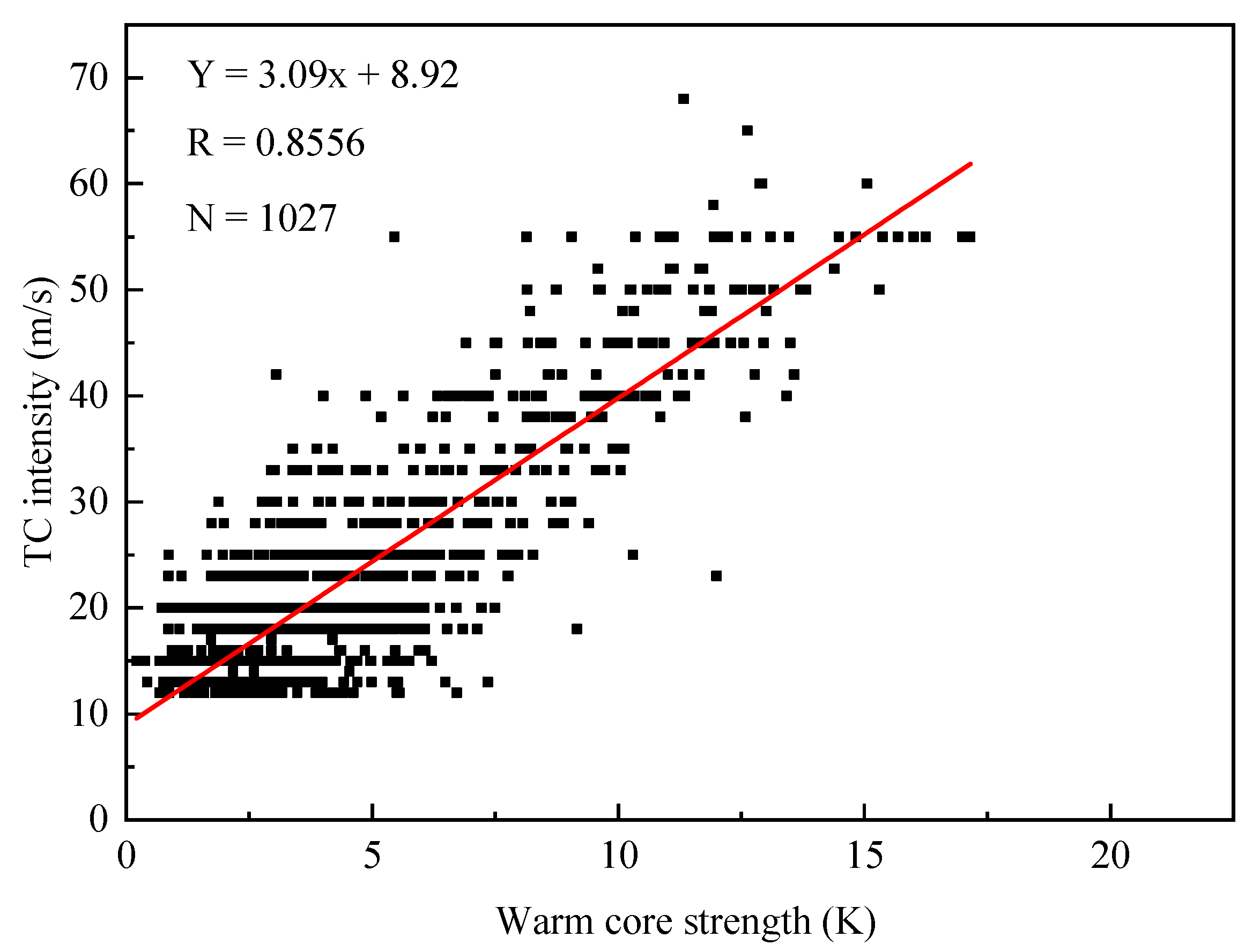
To reveal the relationship between warm-core strength and TC intensity, we developed a scatter plot of all samples and performed a linear fit to calculate the correlation coefficient between them (Figure 2). TC intensity was positively correlated with warm-core strength, with an R-value of 0.8556 and a fitting line slope of 3.09; this matches the results of Zhao [54].
In order to understand the relationship between warm-core intensity and wind speed for the same TC intensity, we calculated the correlation coefficients for six TC intensity classes (Table 3). For TD, the correlation coefficient between the warm core strength and TC intensity was 0.064 and the p-value was 0.21 (>0.01), meaning that the F test was not passed and these data were irrelevant. Because the development of convection around the TC center was not strong enough, the nearby sinking and warming effect and latent heat heating were weak, such that the temperature anomalies between the center and the surrounding area differed only slightly. Inversion errors in AIRS temperature data may also have erased weak warm cores. The correlation coefficient was 0.185 for TS and STS, 0.469 for TY, and 0.334 for STY. Their p-values were all less than 0.01, indicating that they were correlated under this intensity. However, Super TY had a correlation coefficient of only 0.073, and the F test result did not pass the 0.01 reliability test. When the TC intensity and the convection are both strong, the sinking warming effect and the latent heat heating reach their apex, such that further internal temperature increases become small and re-intensification of the TC becomes difficult.

3.2. Warm Core Height Distribution

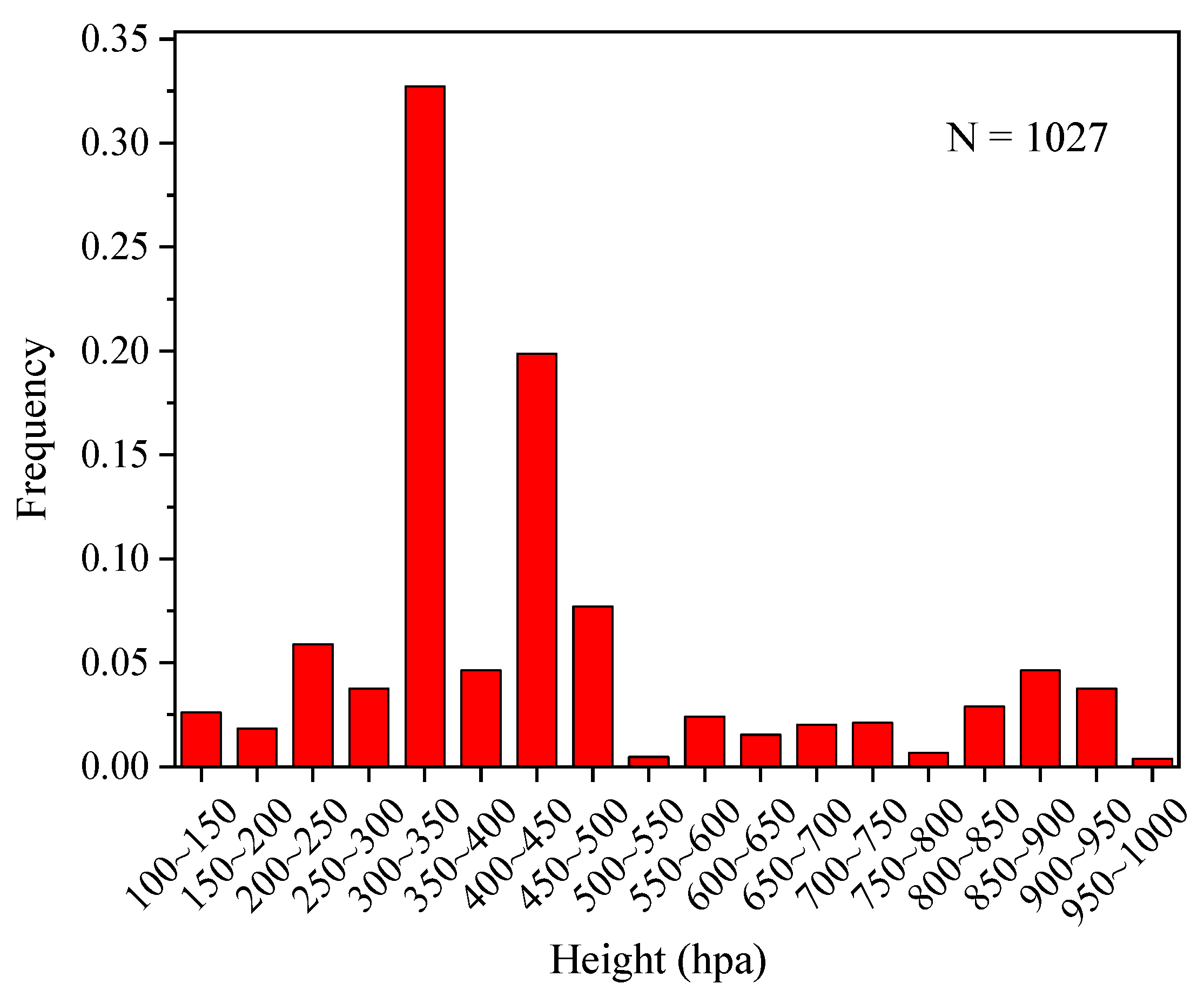
Figure 3 shows the altitude distribution of the warm core in all 1027 samples, which was mainly concentrated from 200 to 500 hPa (76.1% of all samples), consistent with previous results [34,54]. The highest individual ranges were 300–350 hPa (33% of tall samples) and 400–450 hPa (19% of all samples), while all others were <10%.
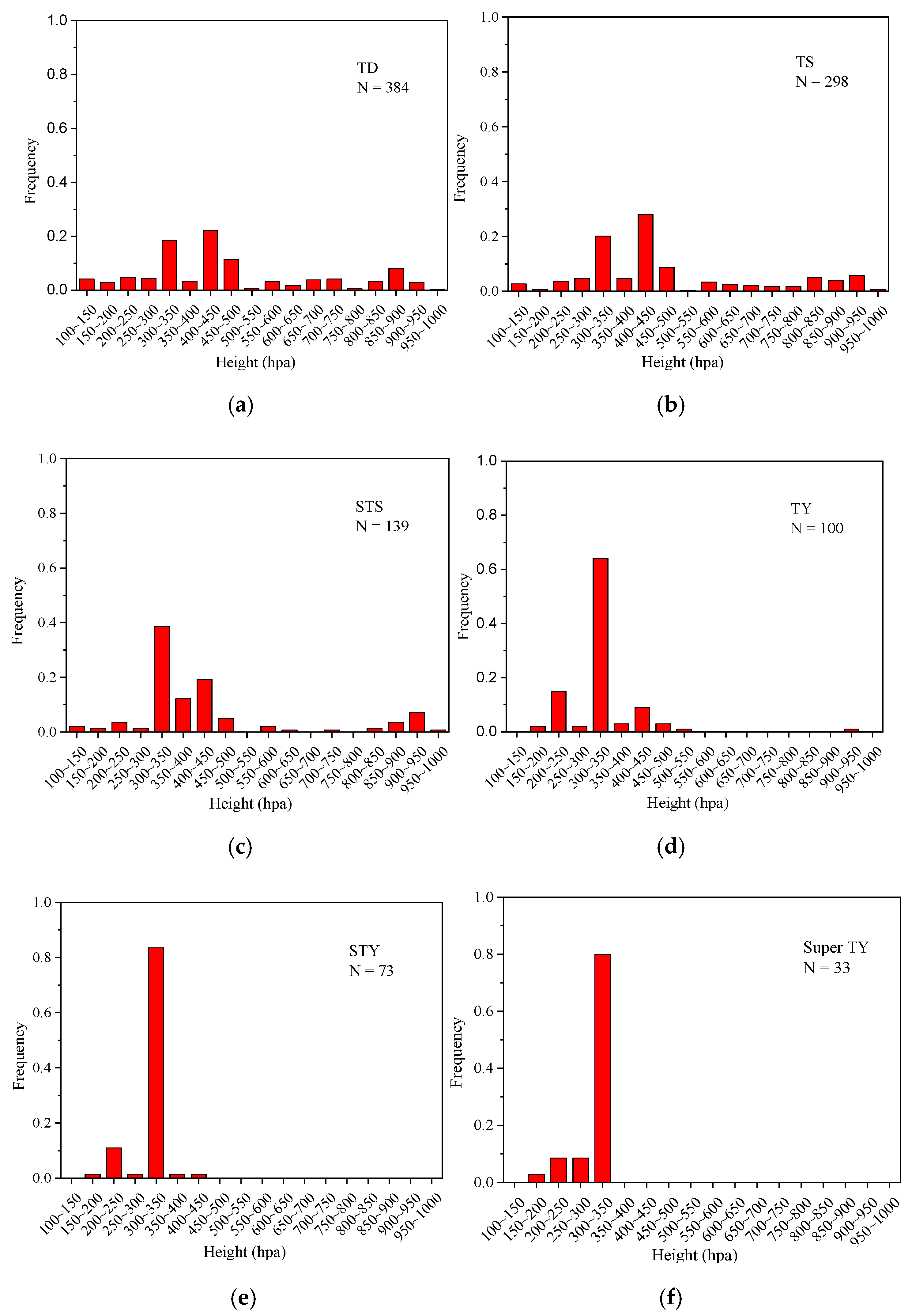
The distribution of the warm core height for different TC intensities was quite variable (Figure 4). For TD, the strongest warm core was distributed throughout the layers but was mainly concentrated from 300 to 500 hPa. The largest height was from 400 to 450 hPa (25%), followed by 300–350 hPa (16%) and 450–500 hPa (12%). The warm core height distribution was similar for TS, for which all the heights were again represented but mainly concentrated from 300 to 500 hPa. The warm core height in the range of 400–450 hPa was the largest, accounting for 27%. For STS, the dominant range of warm core height was 300–450 hPa, with the maximum from 300 to 350 hPa (36%), followed by 400–450 hPa (20%).
For TY, 64% of samples were concentrated from 300 to 350 hPa, 15% from 200 to 250 hPa, and the rest from 150 to 200 hPa, 250 to 300 hPa, 350 to 550 hPa, and 900 to 950 hPa. No warm core occurred from 550 to 900 hPa and 950 to 1000 hPa. For STY, almost all warm cores were distributed from 300 to 350 hPa (>80%). For Super TY, all warm core heights occurred above 350 hPa.
In summary, for TD, TS, and STS, the warm core heights were mainly distributed from 300 to 500 hPa, while those for TY, STY, and Super TY were concentrated from 200 to 350 hPa, indicating that the warm core height increased with TC intensity [34]. There were two main reasons why a certain number of samples were distributed below 700 hPa when the TC was classified at or below STS. First, the rising movement of water vapor could be too weak to form a warm core in the upper layer. Second, the AIRS temperature data had larger errors at this level.

3.3. Analysis of Warm Core Structure with Different TC Intensities

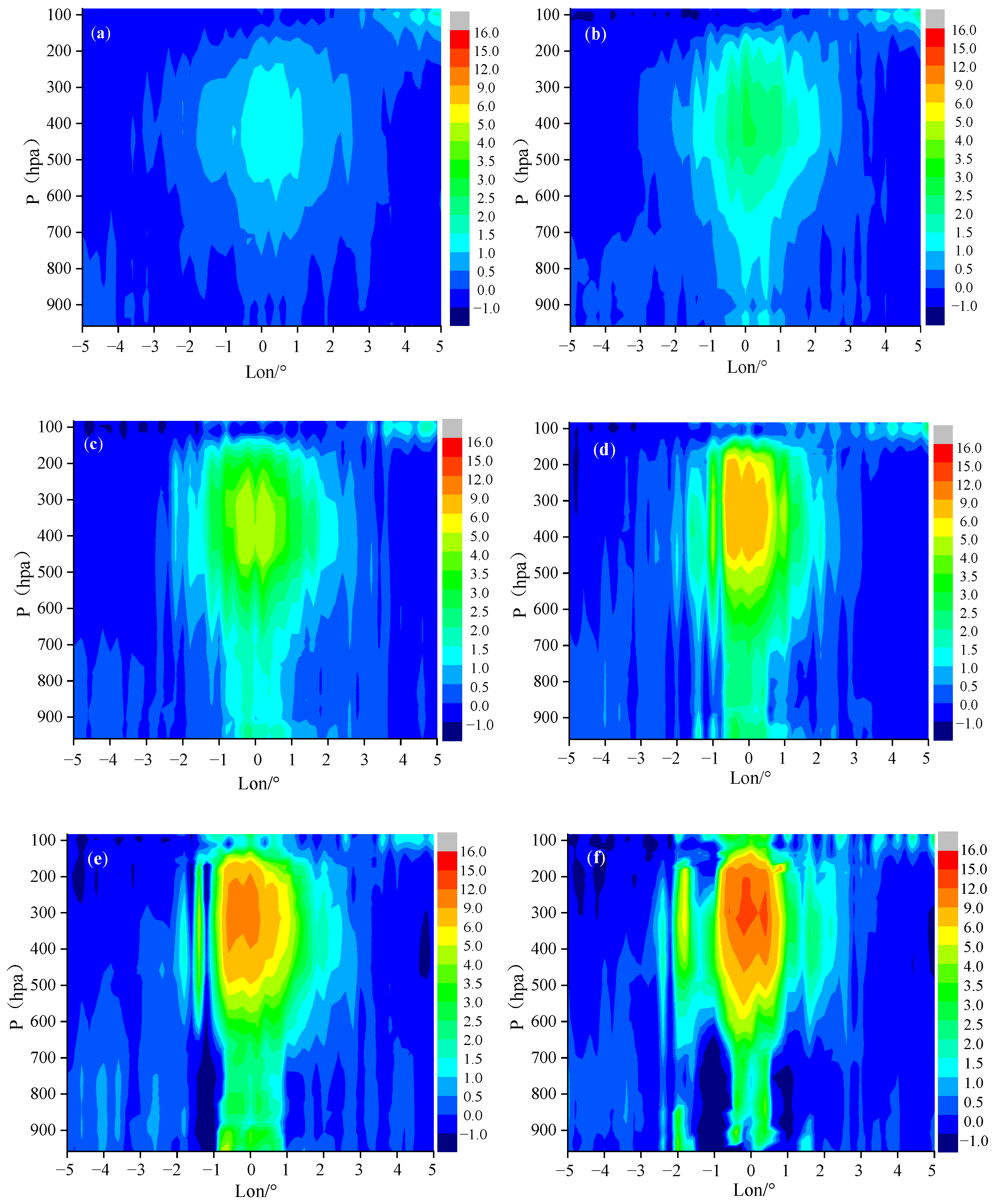
The vertical temperature anomaly distributions of all 1027 samples were analyzed synthetically with the TC center as the axis. Figure 5 shows vertical profiles of the temperature anomaly for each TC class after synthesis (transect along the center of the TC latitude from east to west), where point 0 of the X-axis is the TC center. At different TC intensities, the shape of the warm core structure in the TC’s upper layer changed significantly. For TD, the shape of the warm core was approximately elliptical, with a long axis in the vertical direction, the warm core height extending up to 200 hPa, and the warm core strength ranging from 1 to 1.5 K. For TS, the warm core extended up to 160 hPa and down to 900 hPa, while its strength increased to 3.5–4 K. For STS, the warm core strength continued to increase, reaching 5–6 K and then extending upward from 150 to 950 hPa. For TY, STY, and Super TY, the warm cores all extended up to 100 hPa and their strengths increased to 6–9 K, 9–12 K, and >15 K, respectively.
When TC intensity reached TS, the shape of the warm core became uneven, with a relatively broad warm core in the upper layer, while the middle and lower layers concentrated in a relatively narrow range near the TC center. This was similar to the results from TC case studies published by Li and Luo [56]. The warm core height gradually increased with increasing TC intensity, different from conclusions in Zhang [57]. This is due to the synthetic analysis of large samples in our study, which provides a more comprehensive overview of the warm core structures under different environmental conditions and different intensity levels; this approach is bound to produce results different from individual diagnosis analyses using different data.

3.4. Analyses of Macro-/Micro- Physical Properties of TC Cloud Systems by Intensity

Cloud type varies with differing TC intensity. Based on cloud-top temperature, clouds were divided into three categories: ice clouds (cloud-top temperature <260 K), water clouds (cloud-top temperature >273.15 K) and ice-water mixed clouds (cloud-top temperature 260–273.15 K) [58]. The proportions of different cloud types on the top of TC cloud system for all six TC intensity classes then were counted (Table 4). For TD, TS, and STS, ice clouds accounted for ~95% of the total, and water clouds for ~1.6%. For TY, STY, and Super TY, ice clouds accounted for ~98%, ice-water mixed clouds for 1.02–1.49%, and water clouds for 0.15–0.34%. In general, on the top of TC cloud system, ice clouds accounted for >90% of the total, regardless of TC intensity, far more than the other types. The proportion of ice-water mixed clouds was slightly higher than that of water clouds, with the other two combined accounting for <6%. Therefore, we primarily focused on the macro-/micro- physical properties of ice clouds in TCs of different intensities.
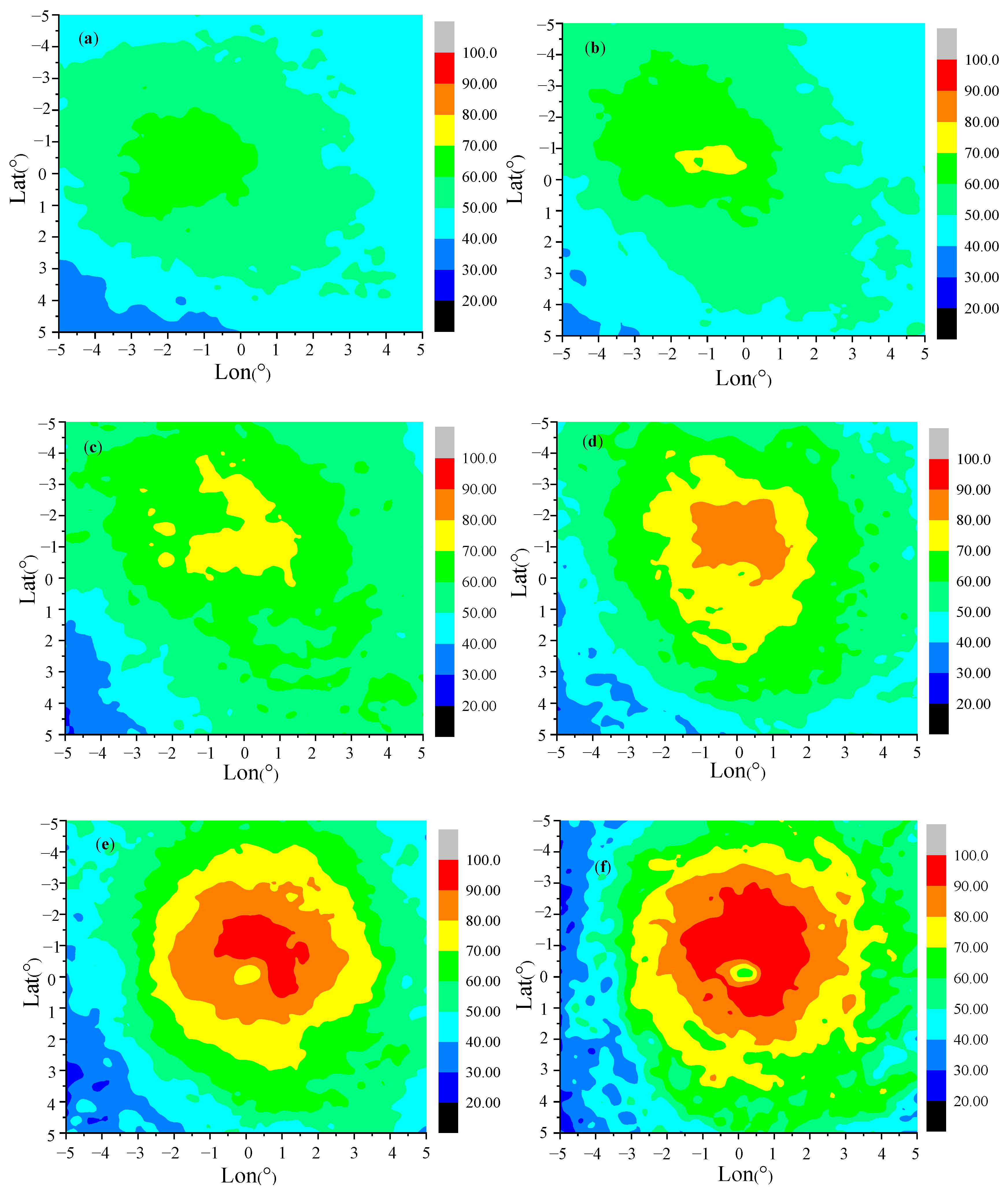
Figure 6 shows the spatial distribution of ice cloud fraction for all TC intensity classes. When TC intensity increased, the ice cloud fraction near the TC center increased while decreasing outward from the center. For TD, the high-value (0.6–0.7) area of ice cloud fraction was located northwest of the TC center with an irregular shape. For TS, the high-value increased to 0.7–0.8. For STS and TY, the high-value area of ice cloud fraction was located north of the TC center, with maximum values of 0.7–0.8 and 0.8–0.9, respectively. For STY and Super TY, the maximum of ice cloud fraction reached 0.9–1.0. Because TC spiral cloud-rain band was relatively complete and symmetrical, the high-value area of ice cloud fraction tended to be symmetrically distributed around the TC center and most TC would form a clear typhoon eye, where there was little or no cloud coverage. Stronger TCs generally had a clearer typhoon eye, especially for Super TY. The existences of clouds could decrease solar radiation reaching the earth surface and increase longwave radiation absorbed by the whole atmosphere in TC inner core [59], therefore, the contribution of the vertical heat transport by clouds to the warm core strength was significant.
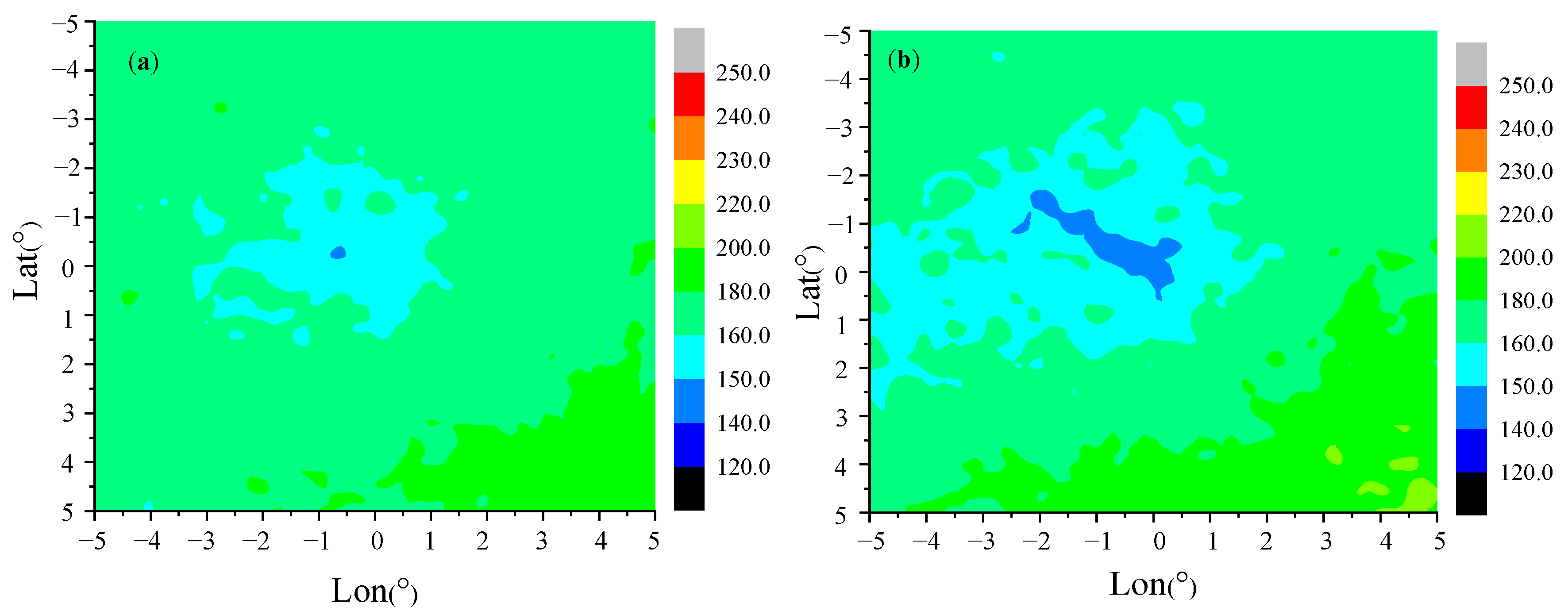
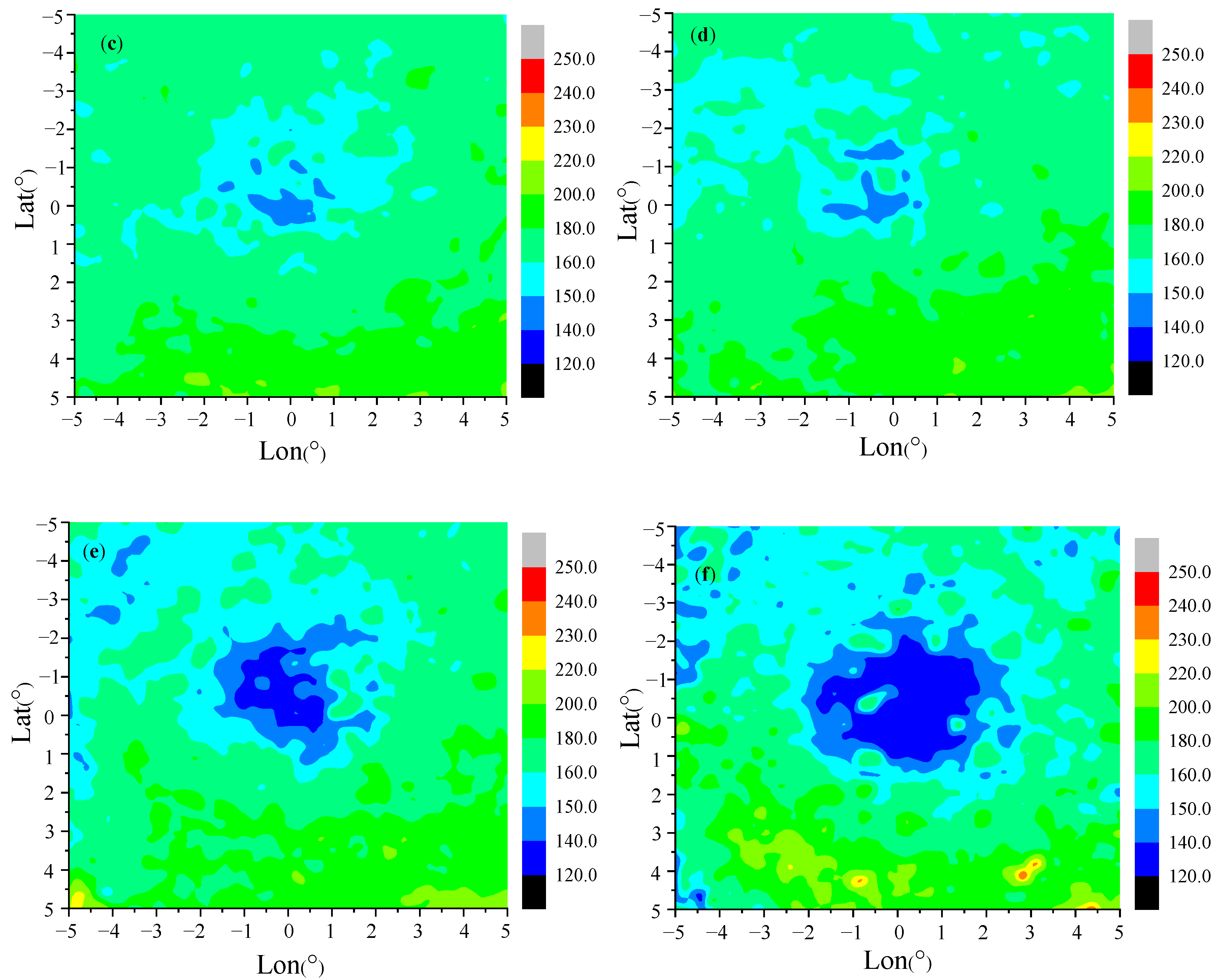
Figure 7 shows the spatial distribution of cloud-top pressure for different TC intensity classes. The distribution and numerical range varied, but all low-value areas appeared near the TC center, where the clouds reach their highest altitude [46]. Stronger TCs generally had larger regions of low cloud-top pressure near the center. For TD, TS, STS, and TY, the lowest value range of ice cloud-top pressure was 140–150 hPa, with an extremely irregular shape. The low-value zone in the TS cloud-top pressure formed a narrow strip, while those of STS and TY were mainly distributed near the TC center. For STY and Super TY, the cloud-top pressure reached the range of 120–150 hPa and the high clouds were much nearer to the TC center.
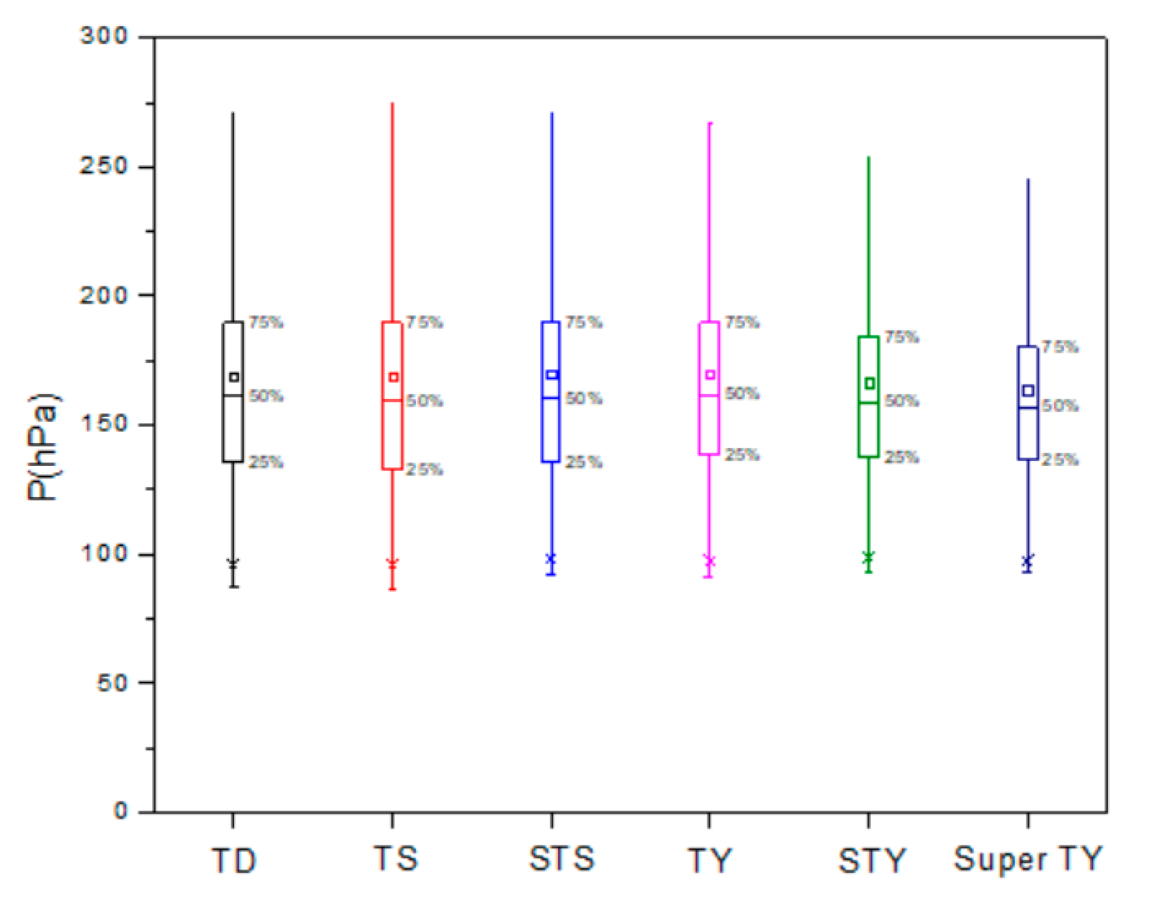
In order to effectively and intuitively identify sample data characteristics and outliers as well as determinations of dispersion degree and bias, the characteristics of ice cloud-top pressure by different TC intensity were counted as shown in Figure 8. Regardless of TC intensity, 75% were found at <200 hPa. The ice cloud-top pressure samples for different TC intensity classes were evenly distributed and the mean values for all classes were larger than the median values. With increasing TC intensity, the box length tended to be shorter, indicating that high clouds increased, especially for Super TY.
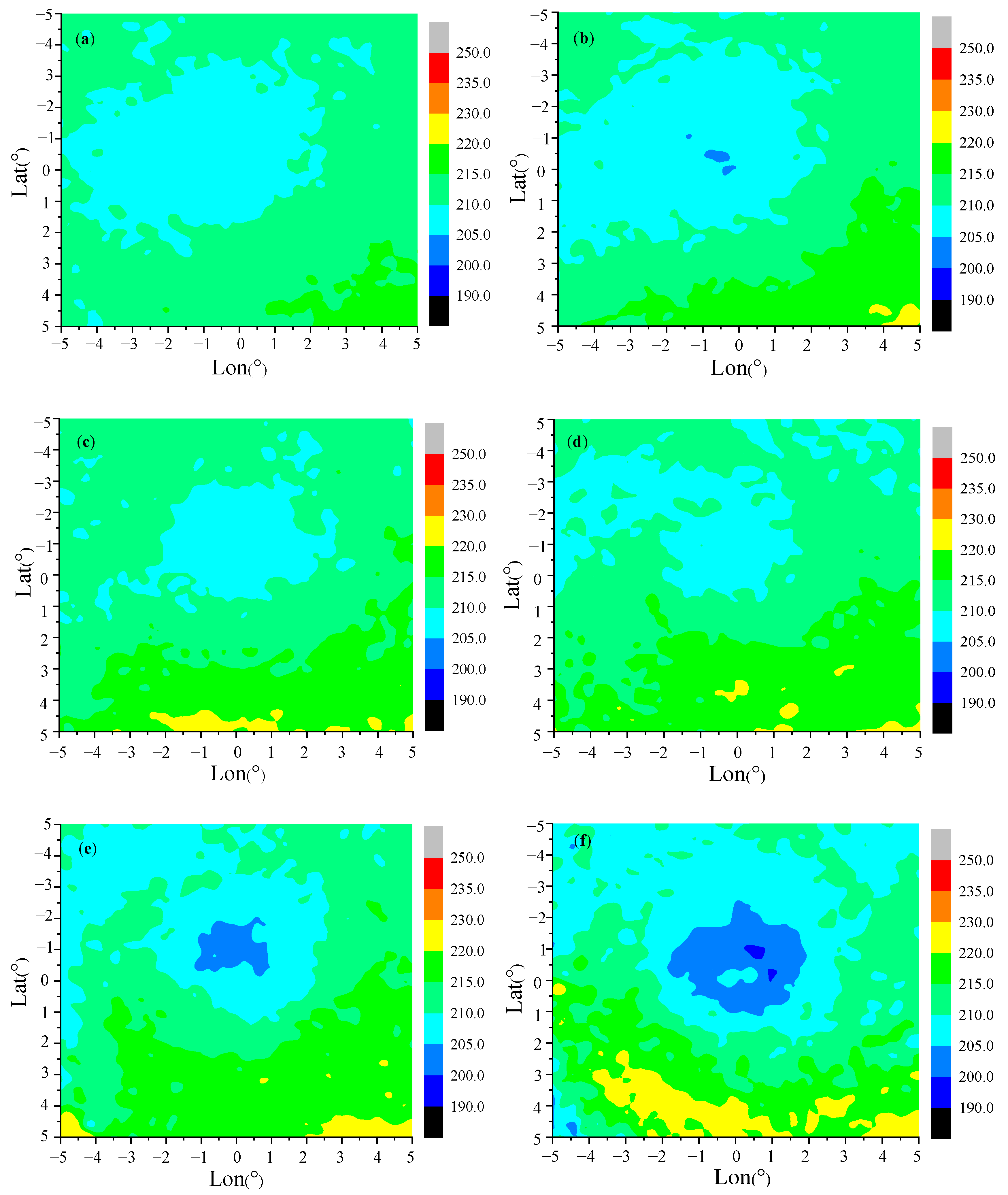
Figure 9 shows the spatial distribution of ice cloud-top temperature by TC intensity. Stronger TCs had larger regions of low cloud-top temperature near the center and high cloud-top temperature far from the center. For TD, STS, and TY, the cloud-top temperatures ranged from 205 to 220 K and the low-value areas were mainly located near the TC center. For TS, the ice cloud had larger cloud-top temperature areas with a lower value ranging from 200 to 205 K near the TC center. For STY, the cloud-top temperature near the TC center decreased further with increasing cloud-top height. For Super TY, the lower-temperature areas near the TC center were further increased but a small area with slightly higher temperature (~5 K) occurred near the center, which might be affected by the warm core.
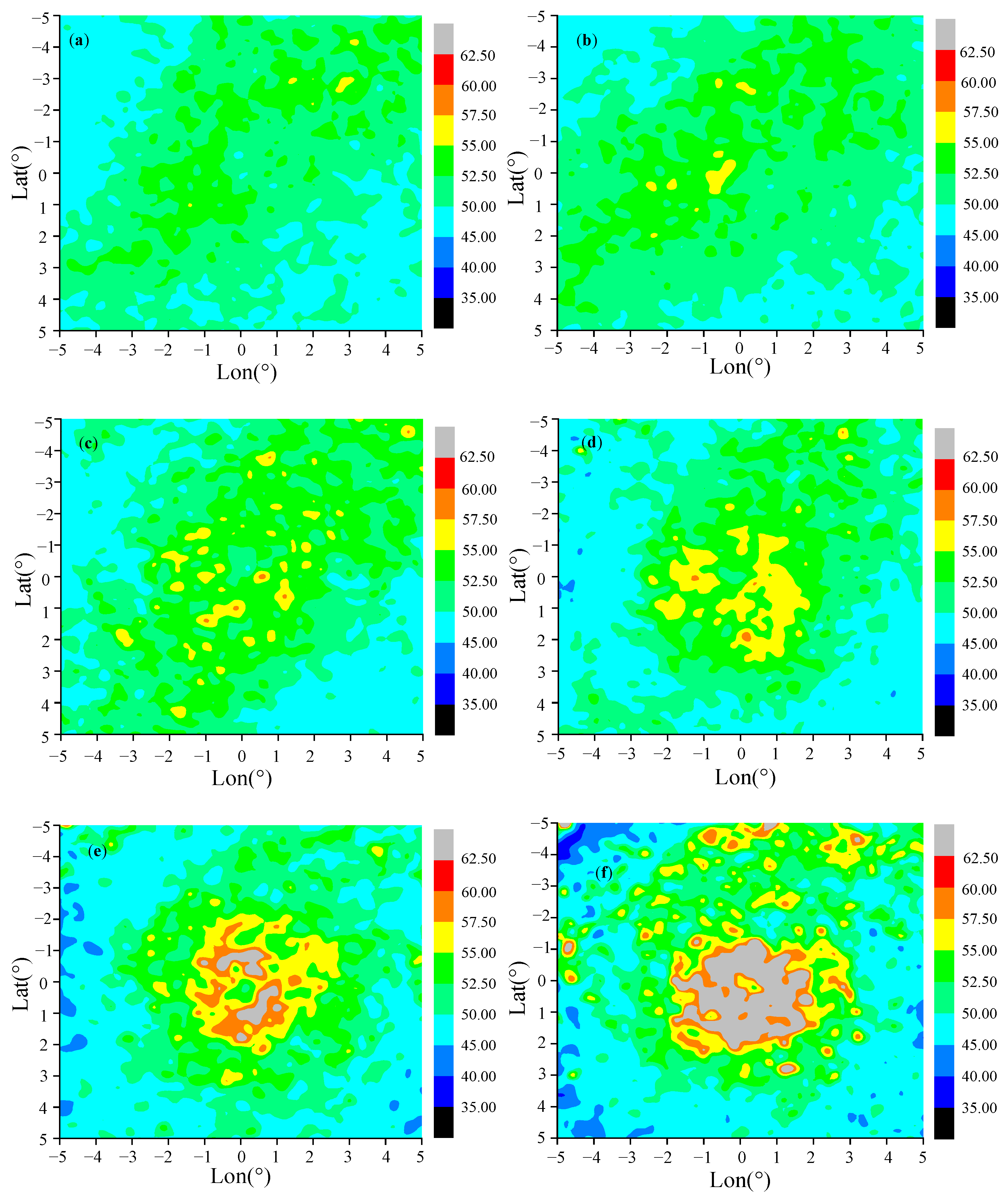
Figure 10 shows the spatial distribution of the cirrus effective diameter by TC intensity. Cirrus was mainly concentrated in the upper layers of the TC cloud system [60], so the cirrus effective diameter in this study only stood for the ice particles on the top of the TC cloud system. For TD, the high-value range was 50–52.5 μm, mainly distributed in a strip from southwest to northeast; this area also contained a small number of 52.5–57.5 μm. The spatial distribution for TS was consistent with that for TD. For STS and TY, a small number of ice particles with an effective diameter of 57.5–60 μm appeared dispersedly in the high-value areas and the areas with ice particles effective diameter ranging from 55 to 57.5 μm increased. For TY, the high-value areas tended to gather near the TC center. For STY, the diameters of cloud ice particles ranged from 52.5 to 55 μm and 55 to 60 μm around the TC center. For Super TY, the distribution was similar to that for STY but the low-value area near the TC center was smaller. The maximum diameter of ice particles near the TC center was greater than 60 μm and the high-value areas were much larger. Some large particles of cirrus could still be found far from the TC center, indicating there was an outflow of cirrus for Super TY [60].

4. Conclusions

We used AIRS data to analyze the temperature profiles for different TC intensity classes as well as the macro-/micro-physical properties of clouds with the following conclusions:
(1)
There was a positive correlation between TC intensity and warm core strength (correlation coefficient is 0.8556). Correlation coefficients varied by intensity class, with the highest value (0.496) for TY. The linear fitting results also showed that TC intensity increased with increasing warm core strength. However, warm core strength and TC intensity were not correlated for TD because the convection around the TC center was not strong enough, weakening the nearby sinking warming and latent heat heating effects; the temperature anomalies between the TC center and the surrounding area were slightly different. In addition, inversion errors within the AIRS temperature data might also have erased the weak warm cores.
(2)
Vertical distributions of warm core height varied with TC intensity and warm core height slightly increased as TC intensity increased. For TD and TS, warm core heights were mainly distributed from 300 to 500 hPa, the range of STS was from 300 to 450 hPa, and that of TY and Super TY from 300 to 350 hPa. The vertical distribution of temperature structure showed that the warm core strength increased gradually from 1 K for TD to >15 K for Super TY. The vertical areas affected by warm core strength grew with increasing TC intensity.
(3)
The tops of TC cloud systems mainly consisted of ice clouds, which accounted for more than 90% of all samples regardless of the TC intensity. As TC intensity increased, cloud fraction and effective diameter of ice particles near the TC center gradually increased, while cloud-top pressure and temperature gradually decreased. With the increase in TC intensity, the vertical convection was stronger and the vertical heat transport by clouds was more significant, contributing to a warmer warm core.

Author Contributions

Conceptualization, Y.C. and B.Z.; methodology, H.W. and B.Z.; validation, Q.L. and X.L.; formal analysis, H.W.; investigation, W.J. and H.Z.; writing—original draft preparation, H.W. and W.J.; writing—review and editing, Q.L.; project administration, Y.C. and B.Z.; funding acquisition, Y.C. and Q.L. All authors have read and agreed to the published version of the manuscript.

Funding

This research was funded by the Chinese Ministry of Science and Technology (grant number 2018YFC1506305) and the 2018 Open Research Program of the State Key Laboratory of Severe Weather (grant number 2018LASW-B11).

Acknowledgments

The AIRS data were obtained from the NASA Goddard Earth Sciences Data Information and Services Center (GES DISC). We thank three anonymous reviewers and the editors for their helpful comments.

Conflicts of Interest

The authors declare no conflict of interest.

References

  1. Liu, Q.; Weng, F. Detecting the warm core of a hurricane from the Special Sensor Microwave Imager Sounder. Geophys. Res. Lett. 2006, 33, L06817. [Google Scholar] [CrossRef]
  2. Zhang, H.; Chou, J.; Qiu, C. Assimilation analysis of Rammasun typhoon structure over Northwest Pacific using satellite data. Chin. Sci. Bull. 2004, 49, 389–395. [Google Scholar] [CrossRef]
  3. Wei, Y.; Xu, J.; Zhou, X. Application of NOAA-AMSU microwave soundings to Typhoon Dujuan. J. Trop. Meteorol. 2005, 21, 359–367. (In Chinese) [Google Scholar]
  4. Zhu, X.; Yu, H.; Yin, Q.; Mao, Z. Satellite-based analysis of concentric eyewall replacement cycles with super Typhoon Muifa (1109). J. Trop. Meteorol. 2014, 30, 34–44. (In Chinese) [Google Scholar]
  5. Ritchie, E.A.; Wood, K.M.; Rodríguez-Herrera, O.G.; Piñeros, M.F.; Tyo, J.S. Satellite-Derived Tropical Cyclone Intensity in the North Pacific Ocean Using the Deviation-Angle Variance Technique. Wea. Forecast. 2014, 29, 505–516. [Google Scholar] [CrossRef] [Green Version]
  6. Wang, X.; Ren, Y.; Li, X. The warm-core structure of Super Typhoon Rammasun derived by FY-3C microwave temperature sounder measurements. Atmos. Sci. Let. 2016, 17, 432–436. [Google Scholar] [CrossRef] [Green Version]
  7. Yan, L.; Zhou, Y.; Liu, X. Dynamic and thermodynamic structure analysis of Typhoon Matmo (1410) and associated moisture characteristics before and after its landfall. Chin. J. Atmos. Sci. 2017, 41, 289–301. (In Chinese) [Google Scholar]
  8. Yu, Z.; Wang, Y.; Xu, H.; Davidson, N.; Chen, Y.; Chen, Y.; Yu, H. On the Relationship between Intensity and Rainfall Distribution in Tropical Cyclones Making Landfall over China. J. Appl. Meteorol. Clim. 2017, 56, 2883–2901. [Google Scholar] [CrossRef]
  9. Zhang, W.; Rutledge, S.A.; Xu, W.; Xu, W.; Zhang, Y. Inner-core lightning outbreaks and convective evolution in Super Typhoon Haiyan (2013). Atmos. Res. 2019, 219, 123–139. [Google Scholar] [CrossRef]
  10. Chane Ming, F.; Jolivet, S.; Liou, Y.-A.; Jégou, F.; Mekies, D.; Hong, J.-S. Elliptical structures of gravity waves produced by Typhoon Soudelor in 2015 near Taiwan. Atmosphere 2019, 10, 260. [Google Scholar] [CrossRef] [Green Version]
  11. Chen, B.-F.; Chen, B.; Lin, H.-T.; Elsberry, R.L. Estimating Tropical Cyclone Intensity by Satellite Imagery Utilizing Convolutional Neural Networks. Weather Forecast. 2019, 34, 447–465. [Google Scholar] [CrossRef]
  12. Jiang, H.; Tao, C.; Pei, Y. Estimation of Tropical Cyclone Intensity in the North Atlantic and Northeastern Pacific Basins Using TRMM Satellite Passive Microwave Observations. J. Appl. Meteorol. Clim. 2019, 58, 185–197. [Google Scholar] [CrossRef] [Green Version]
  13. Wang, J.; Zhang, L.; Guan, J.; Zhang, M. Comparison of assimilating all-sky and clear-sky satellite radiance for Typhoon Chan-Hom and Nangka forecasts. Atmosphere 2020, 11, 599. [Google Scholar] [CrossRef]
  14. Velden, C.S.; Herndon, D. A Consensus Approach for Estimating Tropical Cyclone Intensity from Meteorological Satellites: SATCON. Weather Forecast. 2020, 35, 1645–1662. [Google Scholar] [CrossRef]
  15. Chen, L.; Xu, X.; Luo, Z.; Wang, J. Introduction to Tropical Cyclone Dynamics; China Meteorological Press: Beijing, China, 2002; p. 317. (In Chinese) [Google Scholar]
  16. Brand, S. Interaction of binary tropical cyclones of the western North Pacific Ocean. J. Appl. Meterol. 1970, 09, 433–441. [Google Scholar] [CrossRef]
  17. Stern, D.P.; Zhang, F. The warm-core structure of Hurricane Earl (2010). J. Atmos. Sci. 2016, 73, 3305–3328. [Google Scholar] [CrossRef]
  18. Kidder, S.Q.; Goldberg, M.D.; Zehr, R.M.; DeMaria, M.; Purdom, J.F.W.; Velden, C.S.; Grody, N.C.; Kusselson, S.J. Tropical Cyclone Analysis using AMSU Data. In Proceedings of the AMS 10th Conference on Satellite Meteorology and Oceanography, Long Beach, CA, USA, 14–18 January 2020; pp. 185–188. [Google Scholar]
  19. Kidder, S.Q.; Goldberg, M.D.; Zehr, R.M.; DeMaria, M.; Purdom, J.F.W.; Velden, C.S.; Grody, N.C.; Kusselson, S.J. Satellite analysis of tropical cyclones using the Advanced Microwave Sounding Unit (AMSU). Bull. Amer. Meteorol. Soc. 2000, 81, 1241–1259. [Google Scholar] [CrossRef] [Green Version]
  20. Liu, Z.; Li, W.; Han, Z.; Yao, Z.; Zhang, F.; Zhu, Y. Estimating the intensity of tropical cyclone in Western North Pacific basin with AMSU-A brightness temperature. Chin. J. Geophys. -Chin. Ed. 2008, 51, 51–57. [Google Scholar] [CrossRef]
  21. Zhong, Y.; Xu, M.; Wang, Y. Thermal structure characteristics of the extratropical transition of Tropical Cyclone Chaba (0417). J. Appl. Meteorol. Sci. 2008, 19, 588–594. [Google Scholar]
  22. Wang, Y.; Zhang, H.; Wang, B.; Han, Y.; Cheng, X. Reconstruct the Mesoscale Information of Typhoon with BDA Method Combined with AMSU-A Data Assimilation Method. Adv. Meteorol. 2010, 2010, 346516. [Google Scholar] [CrossRef]
  23. Tian, X.; Zou, X. Capturing size and intensity changes of hurricanes Irma and Maria (2017) from Polar-Orbiting Satellite Microwave Radiometers. J. Atmos. Sci. 2018, 75, 2509–2522. [Google Scholar] [CrossRef]
  24. Zhang, Z.; Wang, Y.; Zhang, W.; Xu, J. Coastal ocean response and its feedback to typhoon Hato (2017) over the South China Sea: A Numerical Study. J. Geophys. Res. -Atmos. 2019, 124, 13731–13749. [Google Scholar] [CrossRef]
  25. Tang, X.; Ping, F.; Yang, S.; Li, M.; Peng, J. On the rapid intensification for Typhoon Meranti (2016): Convection, warm core, and heating budget. Front. Earth Sci. 2019, 13, 791–807. [Google Scholar] [CrossRef]
  26. Shin, J.H. Vortex spinup process in the extratropical transition of Hurricane Sandy (2012). J. Atmos. Sci. 2019, 76, 3589–3610. [Google Scholar] [CrossRef]
  27. Deng, L.; Gao, W.; Duan, Y.; Wang, Y. Microphysical properties of rainwater in Typhoon Usagi (2013): A numerical modeling study. Adv. Atmos. Sci. 2019, 36, 510–526. [Google Scholar] [CrossRef]
  28. Oyama, R.; Wada, A. The relationship between convective bursts and warm-Core intensification in a nonhydrostatic simulation of Typhoon Lionrock (2016). Mon. Weather Rev. 2019, 147, 1557–1579. [Google Scholar] [CrossRef]
  29. Stern, D.P.; Nolan, D.S. On the Height of the Warm Core in Tropical Cyclones. J. Atmos. Sci. 2012, 69, 1657–1680. [Google Scholar] [CrossRef]
  30. Durden, S.L. Observed Tropical Cyclone Eye Thermal Anomaly Profiles Extending above 300hPa. Mon. Weather Rev. 2013, 141, 4256–4268. [Google Scholar] [CrossRef]
  31. Zhang, D.; Chen, H. Importance of the upper-level warm core in the rapid intensification of a tropical cyclone. Geophys. Res. Lett. 2012, 39, L02806. [Google Scholar] [CrossRef] [Green Version]
  32. Fei, J. Stability of off-stage wind disturbance under approximate actual wind field conditions. Acta Trop. Meteorol. Sin. 1996, 12, 18–24. [Google Scholar]
  33. Velden, C.S.; Smith, W.L. Monitoring Tropical Cyclone Evolution with NOAA Satellite Microwave Observations. J. Clim. Appl. Meteorol. 1983, 22, 714–724. [Google Scholar] [CrossRef] [Green Version]
  34. Wang, X.; Jiang, H. A 13-year global climatology of tropical cyclone warm-core structures from AIRS data. Mon. Weather Rev. 2019, 147, 773–790. [Google Scholar] [CrossRef]
  35. Gao, S.; Chen, B.; Li, T.; Wu, N.; Deng, W. AIRS-observed warm core structures of tropical cyclones over the western North Pacific. Dyn. Atmos. Ocean. 2017, 77, 100–106. [Google Scholar] [CrossRef]
  36. Zhu, T.; Weng, F. Hurricane Sandy warm-core structure observed from advanced technology microwave sounder. Geophys. Res. Lett. 2013, 40, 3325–3330. [Google Scholar] [CrossRef]
  37. Knight, D.B.; Davis, R.E. Contribution of tropical cyclones to extreme rainfall events in the southeastern United States. J. Geophys. Res. 2009, 114, D23102. [Google Scholar] [CrossRef] [Green Version]
  38. Jiang, H.; Zipser, E.J. Contribution of Tropical Cyclones to the Global Precipitation from Eight Seasons of TRMM Data: Regional, Seasonal, and Interannual Variations. J. Clim. 2010, 23, 1526–1543. [Google Scholar] [CrossRef]
  39. Bagtasa, G. Contribution of Tropical Cyclones to Rainfall in the Philippines. J. Clim. 2017, 30, 3621–3633. [Google Scholar] [CrossRef]
  40. Mei, W.; Primeau, F.; McWilliams, J.C.; Pasquero, C. Sea surface height evidence for long-term warming effects of tropical cyclones on the ocean. Proc. Natl. Acad. Sci. USA 2013, 110, 15207–15210. [Google Scholar] [CrossRef] [Green Version]
  41. Fu, Y.; Xian, T.; Lu, D.; Liu, G.; Heng, Z.; Sun, L.; Liu, Q.; Wang, Y. Ozone vertical variations during a typhoon derived from the OMI observations and reanalysis data. Chin. Sci. Bull. 2013, 58, 3890–3894. [Google Scholar] [CrossRef] [Green Version]
  42. Wu, D.L.; Austin, R.T.; Deng, M.; Durden, S.L.; Heymsfield, A.J.; Jiang, J.H.; Lambert, A.; Li, J.-L.; Livesey, N.J.; McFarquhar, G.M.; et al. Comparisons of global cloud ice from MLS, CloudSat, and correlative data sets. J. Geophys. Res. 2009, 114, D00A24. [Google Scholar] [CrossRef] [Green Version]
  43. Black, R.A.; Hallett, J. Observations of the distribution of ice in hurricanes. J. Atmos. Sci. 1986, 43, 802–822. [Google Scholar] [CrossRef] [Green Version]
  44. Black, R.A.; Hallett, J. Electrification of the hurricane. J. Atmos. Sci. 1999, 56, 2004–2028. [Google Scholar] [CrossRef]
  45. Zhao, S.; Zhou, Y. Using various satellites to study typhoons Ewiniar macro and micro physical characteristics. Plateau Meteorol. 2010, 29, 1254–1260. (In Chinese) [Google Scholar]
  46. Mitrescu, C.; Miller, S.; Hawkins, J. Near-Real-Times applications of CloudSat data. J. Appl. Phys. 2008, 47, 1982–1994. [Google Scholar] [CrossRef]
  47. Zhou, Y.; Han, Y.; Wu, Y.; Wang, T.; Tang, X.; Wang, Y. Optical properties and spatial variation of tropical cyclone cloud systems from TRMM and MODIS in the East Asia region: 2010–2014. J. Geophys. Res. Atmos. 2018, 123, 9542–9558. [Google Scholar] [CrossRef]
  48. Bu, Y.P.; Fovell, R.G.; Corbosiero, K.L. Influence of Cloud–Radiative Forcing on Tropical Cyclone Structure. J. Atmos. Sci. 2014, 71, 1644–1662. [Google Scholar] [CrossRef] [Green Version]
  49. Fovell, R.G.; Bu, Y.P.; Corbosiero, K.L.; Tung, W.; Cao, Y.; Kuo, H.; Hsu, L.; Su, H. Influence of Cloud Microphysics and Radiation on Tropical Cyclone Structure and Motion. Meteorol. Monogr. 2016, 56, 11.1–11.27. [Google Scholar] [CrossRef]
  50. Kieu, C.; Tallapragada, V.; Zhang, D.; Almon, Z. On the development of double warm-core structures in intense tropical cyclones. J. Atmos. Sci. 2016, 73, 4487–4506. [Google Scholar] [CrossRef]
  51. Tobin, D.C.; Revercomb, H.E.; Knuteson, R.O.; Lesht, B.M.; Strow, L.L.; Hannon, S.E.; Feltz, W.F.; Moy, L.A.; Fetzer, E.J.; Cress, T.S. Atmospheric Radiation Measurement site atmospheric state best estimates for Atmospheric Infrared Sounder temperature and water vapor retrieval validation. J. Geophys. Res. 2006, 111, D09S14. [Google Scholar] [CrossRef] [Green Version]
  52. Ying, M.; Zhang, W.; Yu, H.; Lu, X.; Feng, J.; Fan, Y.; Zhu, Y.; Chen, D. An overview of the China Meteorological Administration tropical cyclone database. J. Atmos. Ocean. Technol. 2014, 31, 287–301. [Google Scholar] [CrossRef] [Green Version]
  53. Li, Y. A Study on the Sustaining Mechanism of Landfalling Tropical Cyclones; Chinese Academy of Meteorological Sciences: Beijing, China, 2004; pp. 34–35. (In Chinese) [Google Scholar]
  54. Zhao, L. Application of NOAA/AMSU Data in the Study of Typhoon in the Western Pacific. Master’s Thesis, Ocean University of China, Qingdao, China, 2009. (In Chinese). [Google Scholar]
  55. Niu, X. Tropical Cyclone Dynamics; China Meteorological Press: Beijing, China, 1992; p. 3. [Google Scholar]
  56. Li, Y.; Luo, Z. A case study on the formation of warm core structure of typhoon in the South China Sea. China Sci. Technol. Inf. 2008, 17, 29–32. (In Chinese) [Google Scholar]
  57. Zhang, Z. Application of NOAA/AMSU Temperature Data in the Study of Typhoon Structure and Path. Master’s Thesis, Ocean University of China, Qingdao, China, 2012. (In Chinese). [Google Scholar]
  58. Chen, Y.; Huang, J.; Wang, T.; Jin, H.; Ge, J. The temporal and spatial distribution of different types of clouds and their relationship with precipitation in Northwest China. J. Appl. Meteorol. Sci. 2005, 16, 718–726. (In Chinese) [Google Scholar]
  59. Yan, Y.; Tan, J.; Cui, L.; Yu, W.; Hu, Y. Asymmetry of Cloud Vertical Structures and Associated Radiative Effects in Typhoon over the Northwest Pacific Based on CloudSat Tropical Cyclone Dataset. Asia-Pac. J. Atmos. Sci. 2020, 56, 515–532. [Google Scholar] [CrossRef]
  60. Gao, Y.; Fang, X. Analyses on vertical structure and microphysical features of typhoon cloud in the Western Pacific based on CloudSat satellite data. Meteorol. Mon. 2018, 44, 597–611. (In Chinese) [Google Scholar]
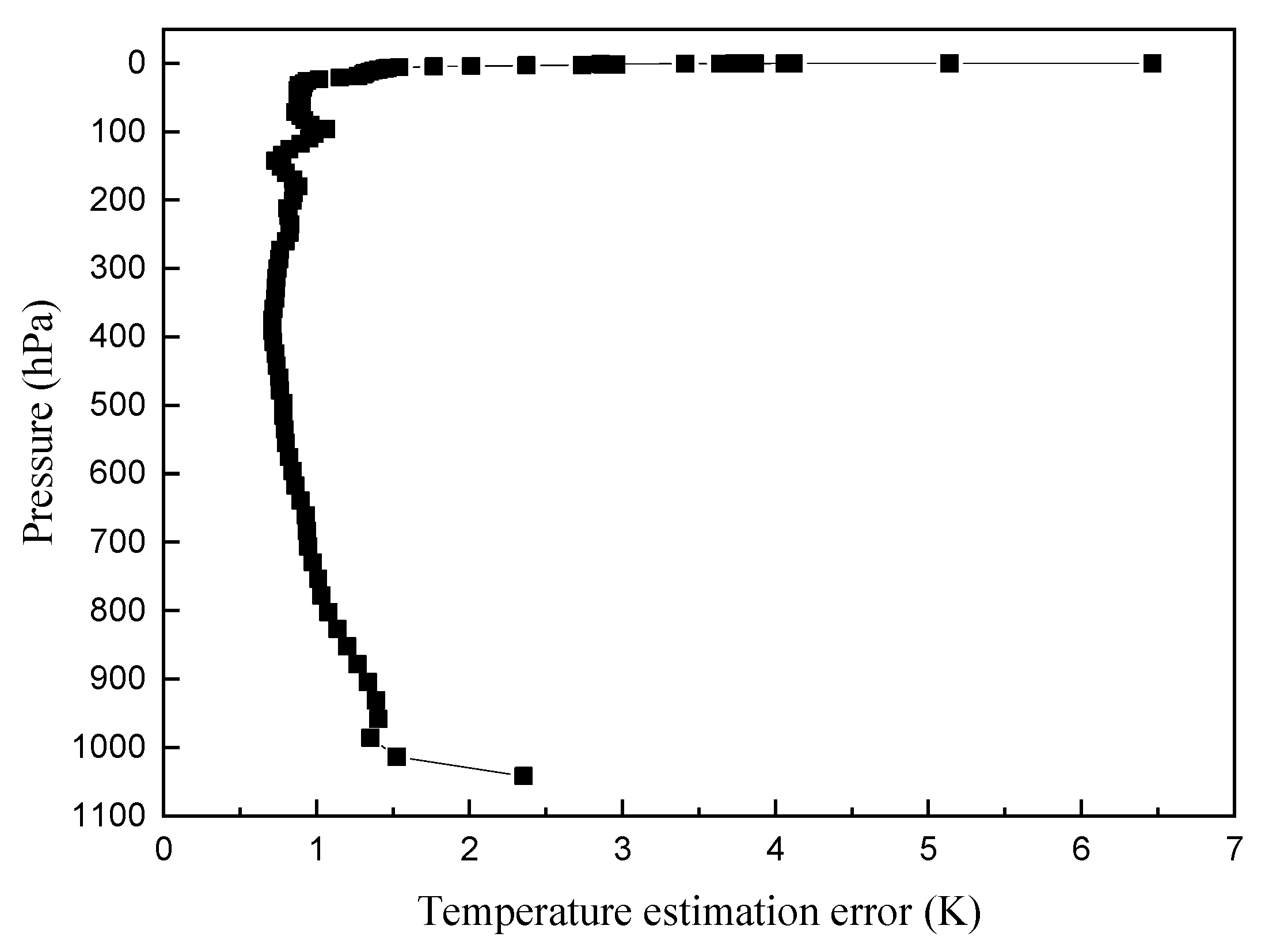
Figure 1. Estimation error profile of AIRS temperature data.
Atmosphere 11 01181 g001
Figure 2. Scatter plot of warm core strength and TC intensity with linear fit (red line).
Atmosphere 11 01181 g002
Figure 3. Warm core height distribution.
Atmosphere 11 01181 g003
Figure 4. Warm-core height for different TC intensities: (a) TD, (b) TS, (c) STS, (d) TY, (e) STY, and (f) Super TY.
Atmosphere 11 01181 g004
Figure 5. Temperature anomaly (K) vertical profiles by TC intensity: (a) TD, (b) TS, (c) STS, (d) TY, (e) STY, and (f) Super TY.
Atmosphere 11 01181 g005
Figure 6. Spatial distribution of ice cloud fraction (%) in different TC intensity: (a) TD, (b) TS, (c) STS, (d) TY, (e) STY, and (f) Super TY.
Atmosphere 11 01181 g006
Figure 7. Spatial distribution of ice cloud top pressure by different TC intensity: (a) TD, (b) TS, (c) STS, (d) TY, (e) STY, and (f) Super TY.
Atmosphere 11 01181 g007aAtmosphere 11 01181 g007b
Figure 8. Statistics of ice cloud top pressure by different TC intensity.
Atmosphere 11 01181 g008
Figure 9. Spatial distribution of ice cloud-top temperature (K) by TC intensity: (a) TD, (b) TS, (c) STS, (d) TY, (e) STY, and (f) Super TY.
Atmosphere 11 01181 g009
Figure 10. Spatial distribution of cirrus effective diameter (μm) by TC intensity: (a) TD, (b) TS, (c) STS, (d) TY, (e) STY, and (f) Super TY.
Atmosphere 11 01181 g010
Table 1. Quality control (QC) for AIRS temperature products.
QCQuality Flag
0Best
1Good
2Do not use
Table 2. Number of tropical cyclone (TC) samples by intensity. Tropical depression (TD), tropical storm (TS), severe tropical storm (STS), typhoon (TY), severe typhoon (STY).
Sample NumberTDTSSTSTYSTYSuper TY
1027384299139997333
Table 3. Correlation between warm core strength and wind speed for the same TC intensity.
TC ClassSample NumberCorrelation Coefficientp-Value(F Test)
TD3840.0640.210
TS2990.1850.001
STS1400.1850.003
TY990.4698.719 × 10−7
STY730.3340.003
Super TY330.0730.6834
Table 4. Cloud type on the top of TC cloud system by different TC intensity.
Top of the TC Cloud SystemTDTSSTSTYSTYSuper TY
Ice cloud (%)94.5895.4695.4598.5998.6798.36
Water cloud (%)1.811.491.710.340.310.15
Ice water mixing cloud (%)3.613.052.841.071.021.49
Publisher’s Note: MDPI stays neutral with regard to jurisdictional claims in published maps and institutional affiliations.