Article

Frequency of Italian Record-Breaking Floods over the Last Century (1911–2020)

by
Attilio Castellarin
1,
Andrea Magnini
1,*,
Kay Khaing Kyaw
1,
Filippo Ciavaglia
1,
Miriam Bertola
2,
Gunter Blöschl
2,
Elena Volpi
3,
Pierluigi Claps
4,
Alberto Viglione
4,
Alberto Marinelli
1 and
Richard M. Vogel
5
1
Department of Civil, Environmental, Chemical and Materials Engineering (DICAM), University of Bologna, 40126 Bologna, Italy
2
Institute of Hydraulic Engineering and Water Resources Management, Vienna University of Technology, 1040 Vienna, Austria
3
Engineering Department, University of Roma Tre, 00154 Rome, Italy
4
Department of Environment, Land and Infrastructure Engineering, Polytechnic University of Turin, 10129 Turin, Italy
5
Department of Civil and Environmental Engineering, Tufts University, Medford, MA 02155, USA
*
Author to whom correspondence should be addressed.
Atmosphere 2024, 15(7), 865; https://doi.org/10.3390/atmos15070865
Submission received: 29 May 2024 / Revised: 16 July 2024 / Accepted: 18 July 2024 / Published: 22 July 2024
(This article belongs to the Special Issue Impacts of Climate Change on Basin Hydrology)

Abstract

:
This study provides an in-depth analysis of the frequency of extreme streamflow in Italy, adopting the innovative perspective of the theory of records, and focusing on record-breaking floods. (i.e., annual maximum series, AMS) observed in Italy between 1911 and 2020. Our research employs an extensive dataset of 522 annual maximum series (AMS) of streamflow observed across Italy between 1911 and 2020. We consider three time intervals (1911–2020, 1911–1970, and 1971–2020), and we define pooling-groups of AMSs based on (a) hydrological (e.g., catchment size, mean annual precipitation, etc.) and (b) spatial proximities of the gauged sites. First, within each group and for each time period, we compute the regional average number of record-breaking events (NRbins). Second, with a series of resampling experiments that preserve the spatial correlation among the AMSs, we test the hypothesis that NRbins result from a group of stationary sequences. Our results show spatially coherent patterns of an increasing number of record-breaking floods in central and in northeastern Italy over the last 50 years. In the same time interval, significant deviations in the regional number of record-breaking events from what would be expected for stationary flood sequences seem to be more common in drier climates or at higher altitudes, while the catchment size does not seem to be a meaningful descriptor.

1. Introduction

The economic losses and social consequences caused by floods have been steadily increasing over the last five decades worldwide [1,2]. Detecting changes in flood frequency is a topical research issue, and the scientific community calls for a common effort to better understand recent flood dynamics and their spatiotemporal evolution.
An increasing number of studies investigate the presence of non-stationarities in the frequency and magnitude of observed and projected peak flows at both the global [3,4] and continental scale [5,6,7]. With specific reference to Europe, recent studies show a complex system of changes in frequency and magnitude of observed floods over the last six decades [8,9,10]. In particular, Ref. [11] observes that in the last five decades, floods dynamics have changed dramatically across Europe. Regional patterns are particularly evident in some areas, e.g., Southern Europe, yet sub-regional patterns (e.g., specific areas of specific regions) may be masked by the filtering criteria (e.g., minimum sample length) adopted in these studies. Several studies investigate the presence of non-stationary patterns at a smaller scale (i.e., national [12,13,14] or regional [15,16]), considering local morpho-climatic effects and uncertainty due to data scarcity, inaccuracy, or fragmentation ([17,18]).
A considerable number of publications adopt a non-stationary framework for modeling flood statistics [19,20]. Some of these focus on particular elements of flood dynamics in single river catchments [21], while others compare different models for frequency analysis of annual maxima in small-to-medium regions [22].
Generally, the theoretical frameworks adopted for this type of analysis are the extreme value [23] and time series analysis [24] theories. These aim to define the best-fit probability distribution that describes the occurrence of extreme values (e.g., streamflow and precipitation [19,25]) and to provide non-parametric tests to detect non-stationarity in the mean or other statistics of the variables of interest (e.g., the Mann–Kendall test, see [26]). However, the extreme value theory is very sensitive to the length of the time series and the possible presence of outliers, which may negatively affect the reliability of the fitted probability distribution [27,28].
The theory of records, or of record-breaking events, is still underutilized in this research area, despite its relevance and potential [29]. This theory investigates the statistical properties of the occurrence and magnitude of those events that exceed (upper records) or are exceeded (lower records) by any other formerly observed events (herein referred to as +records and −records, respectively). This theory offers a framework for analyzing the frequency of extreme events which is nearly independent of the probability distribution of the original variable—in our case, annual maximum discharge [30,31]—and which does not require the probability distribution to be fit to the observed data, thus being less sensitive to the length of the time series than standard flood frequency analyses. For these reasons, it has been widely and successfully applied for assessing the possible presence of non-stationarity in time sequences of several variables, such as temperature [32], monthly and daily precipitation [33,34], and earthquake magnitudes [35], and in a variety of research fields (e.g., sports [36], biology [37], etc., see e.g., [38]). It is worth mentioning that the analysis of non-stationarity in the extremes, based on record-breaking events, recently inspired a software tool for statistical testing [39]. Thus, the application of the theory of records to annual maximum flood sequences can be very useful to improve our knowledge about flood frequency for events of high and very high magnitude [40].
Our study contributes to this research field with an in-depth analysis of the frequency regime of record-breaking floods in Italy. In particular, we focus on an extensive dataset of flood sequences (i.e., annual maximum series, AMS) observed at 522 stream gauges in Italy between 1911 and 2020 and we consider the entire observation period, as well as two consecutive time intervals: 1911–1970 and 1971–2020. We look at two different kinds of record-breaking events in a time series, that is the events with the maximum (+record) or minimum (−record) intensity up to that year, and we focus on the average number of record-breaking events in a region (i.e., in a pooling-group of AMSs), and in the three time-intervals of interest. By performing a series of resampling experiments that preserve the spatial correlation among the AMSs of the pooling group, we test the hypothesis that the observed regional average number of record-breaking events results from a group of stationary sequences. We identify the pooling group of sites by referring to (a) hydrological and (b) spatial proximity. In the first case, we group catchments that are similar in terms of size, mean annual precipitation, mean annual snow depth, elevation, or latitude; in the second case, we use a moving square pooling window of 90 × 90 km2.
Our research questions are as follows: (1) Does the number of record-breaking floods in Italy deviate from what is expected under the iid hypothesis? If so, (2) are recent deviations larger or more frequent than those in the past? (3) Are larger deviations associated with specific sub-regions, or morphological and climatic characteristics?
The main aim of the study is to assess and understand the presence of non-stationarities in the frequency of occurrence of record-breaking events in Italy. Our study is complementary (for the Italian territory) to the work carried out in Ref. [8], as it uses a different perspective and theoretical framework (i.e., analysis of the frequency of record-breaking events instead of the analysis of the magnitude of extreme values) and a much finer spatial resolution (i.e., more sequences of annual maximum floods). These latter features are elements of novelty relative to those employed in previously published studies, combined with the original and general framework adopted for the analyses, which we present in the following paragraph.

2. Data and Methods

2.1. Study Area

Our analysis focuses on 522 annual maximum series (AMS) of flood flows collected across Italy [41] between 1911 and 2020. Beside the total time period (i.e., 1911–2020), the 1911–1970 and 1971–2020 sub-intervals are also considered and studied in the present research. These have been selected based on the findings of Refs. [11,42], who clearly demonstrate that the dynamics of flood events have experienced a dramatic change across Europe over the last five decades. Table 1 illustrates the variability of the AMS record length over the three different time intervals considered in the study. Figure 1a depicts the geographical distribution of the study stream gauges, their drainage areas, and the availability of the observed annual maxima in the three time intervals considered.
A number of catchment descriptors are retrieved. These include the basin’s size (A), mean annual precipitation (MAP), mean annual snow water equivalent (SWE), minimum elevation (ME), and latitude of catchment centroid (LC). All morphological descriptors (i.e., A, ME, LC) were computed from the 90 m Multi Error Removed Improved Terrain Data Elevation Model (MERIT DEM, [43,44]), while catchment scale climatic indices (i.e., MAP and SWE) were computed from the 1 km gridded datasets available from the BIGBANG project (Italian GIS-based national water balance, see [45]). These static (i.e., time-invariant) catchment descriptors are selected based on the methods of previous relevant studies [46,47,48].
Figure 2 reports the elevation, mean annual precipitation, and mean annual snow water equivalent for the Italian territory for a better characterization of the study area. The main mountain chains are the Alps in the north, with the highest elevation, and the Apennines, which cross all the peninsula (Figure 2a). The MAP decreases from north to south, and generally increases where the elevation is higher (Figure 2b). The SWE is basically different from zero only in mountain areas and in the north (Figure 2c).

2.2. Number of Record-Breaking Events in Independent and Identically Distributed (iid) Series

A record-breaking event, or record event, is defined as an event whose magnitude either exceeds (+record) or is exceeded (−record) by all previously observed events [29,49]; the first observation in a sequence is generally counted as a (trivial) record. Let us consider a sequence of independent and identically distributed (iid) random variables of length n; then, the number of records in the series R is a random variable, whose probability distribution is totally independent of the probability distribution of the original variable (e.g., annual maximum floods in a given cross-section) with mean, μ R , and variance, σ R 2 , defined as:
μ R = i = 1 n 1 / i
σ R 2 = i = 1 n 1 / i i = 1 n 1 / i 2
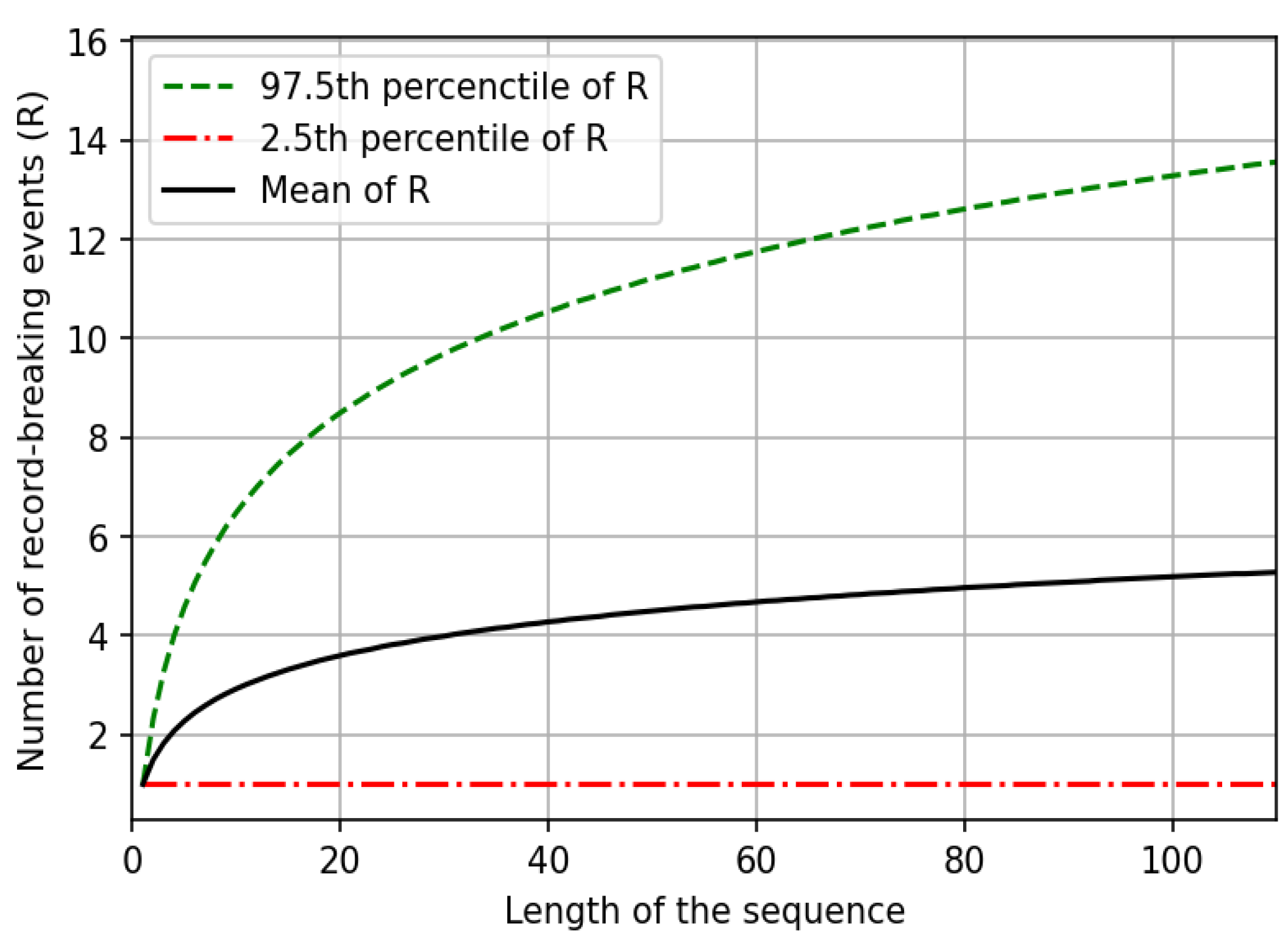
Figure 3 illustrates the progression of μ R (black line) with n, together with the 2.5th and 97.5th percentiles of R. It is interesting to note the rather limited expected number of records for an iid sequence with a length of 100 elements. This characteristic renders the number of record-breaking events an interesting variable for detecting possible changes in the frequency distribution of the variable of interest (e.g., annual maximum flooding). Indeed, significant deviations in the number of record-breaking events in an observed time series relative to what is expected under the iid hypothesis indicate non-stationary time series [30].

2.3. Testing the Statistical Significance of the Deviation in the Average Number of Records in Pooling-Groups of AMS of Flood Flows Relative to What Is Expected under the iid Hypothesis

In this study, we focus on the average number of record-breaking events of pooling-groups of AMS of flood flows. We refer to three different historical time periods, namely 1911–2020, 1911–1970, and 1971–2020. We pool together the annual sequences of maximum floods according to two criteria, i.e., hydrological similarity and spatial proximity of the catchments. Both criteria will be better described in Section 2.4.
The main objective of the study is to assess whether the number of record-breaking events observed in a given pooling-group of AMS is compatible with the iid hypothesis (i.e., the AMS of flood flows in the pooling-group may be regarded as a stationary series relative to the frequency of record-breaking events).
First, we compute the number of record-breaking events (for both +record and −record events) in each AMS of the pooling-group. Suppose we have a total of m series in the group; it is worth noting here that each AMS i, with i = 1, 2, …, m, has its own number of records ni. Then, we compute the mean number of records in the pooling-group. Finally, we assess the deviation of this mean value from what would be expected for the same group of AMS (i.e., the group counts m AMS in total) under the iid hypothesis (i.e., each AMS consists of ni realizations of independent and identically distributed random variables, with i = 1, 2, …, m). This is achieved by comparing the average number of records observed in the pooling-group with the distribution of the average number of records in synthetic pooling-groups of iid series having the same sample length of the original series, which we obtained through a bootstrap resampling experiment [50]. In particular, we design the resampling experiments to preserve the existing spatial correlation between annual maximum floods observed in the same year at different stream-gauges, which cannot be neglected when testing the statistical significance of a null hypothesis at a regional scale (on the possible impact of spatial correlation of time series on statistical testing at regional scale see also [30,51,52]). We randomly shuffle 10,000 times the group of AMS year-wise, so that the sequence of data in each time series differs from the original series, yet the distribution of observations among the various AMS in any given year is preserved, together with the AMS length ni, with i = 1, 2, …, m. For each synthetic (i.e., reshuffled) dataset, we compute the regional average number of records as described above for the original pooling-group of AMS. Then, we compare the empirical regional average number of record events with the distribution of 10,000 synthetic regional means obtained through the bootstrap resampling experiments, to test the statistical significance of the observed deviations.

2.4. Criteria for Pooling-Groups Definition

First, we analyzed hydrologically homogeneous pooling-groups of catchments, grouping the dataset according to the five catchment descriptors mentioned in Section 2.1: size (A), mean annual precipitation (MAP), mean annual snow water equivalent (SWE), minimum catchment elevation (ME), and latitude of the catchment centroid (LC). The objective of these experiments is to group hydrologically similar catchments and to verify whether the frequency of record-breaking events at the national scale shows non-stationarity; if so, the non-stationary behavior depends on the catchment descriptors.
We grouped the study catchments into a total of 36 classes by combining the size of the catchments (three classes) with one of the four remaining catchment descriptors (three classes each). For each of the 36 classes, we calculated the regional mean number of record events (+records and −records) by referring to the three time periods, namely 1911–2020, 1911–1970, and 1971–2020. The regional mean number of records (NRbin) was then compared with 10,000 synthetic mean regional records obtained from the bootstrap experiment described above, and the deviation of the empirical value from what is expected under the iid hypothesis assessed at a 10% significance level. The 36 classes of this assessment are presented in Figure 4 for the four combinations (i.e., A-MAP, A-SWE, A-ME, A-LC) and the three different time intervals considered in our study (i.e., 1911–2020, 1911–1970, 1971–2020).
The second part of the study aims to detect the spatial pattern of changes in the frequency of record-breaking events. This is performed by grouping catchments based on spatial proximity. We consider a discretization of Italy into square grid cells of 30 km × 30 km in size, and we pool AMS observed at stream gauges located in any given cell, as well as in the eight surrounding ones (i.e., overall size of the pooling-group: 90 km × 90 km). This spatial subdivision can be visualized in Figure 1c. Specifically, only 90 km × 90 km tiles containing at least five stream gauges are considered when plotting the results so that the outcomes for any tile are never associated with at-site, or local, conditions and are therefore, more robust.
Analogously to what has been described for the hydrological grouping criterion, for each pooling-group of AMS, we compute the regional average number of records (both for +record and −record events) and compare it with the empirical values with the 10,000 synthetic bootstrap regional number of records, focusing on the previously mentioned three time periods.
In summary, in the present study, the possible presence of non-stationarity in annual maximum flood sequences is assessed through the theory of records, and statistical hypothesis testing is performed on pooling-groups of the catchments. Thus, the proposed framework assesses the statistical significance of the results at a regional level, instead of locally, by looking at single time series. According to several recent studies [17,18,53,54], most statistical approaches used for detecting trends or non-stationarity would require very protracted observed time series to perform optimally; these are seldom available, and are very sparse in regards to space. Moreover, time series are often affected by measurement errors and fragmentation. The aggregation of time series into pooling-groups (i.e., regional analysis) helps in reducing the uncertainty and increasing the robustness of these types of analyses.

3. Results

3.1. Pooling-Groups of Hydrologically Similar Catchments

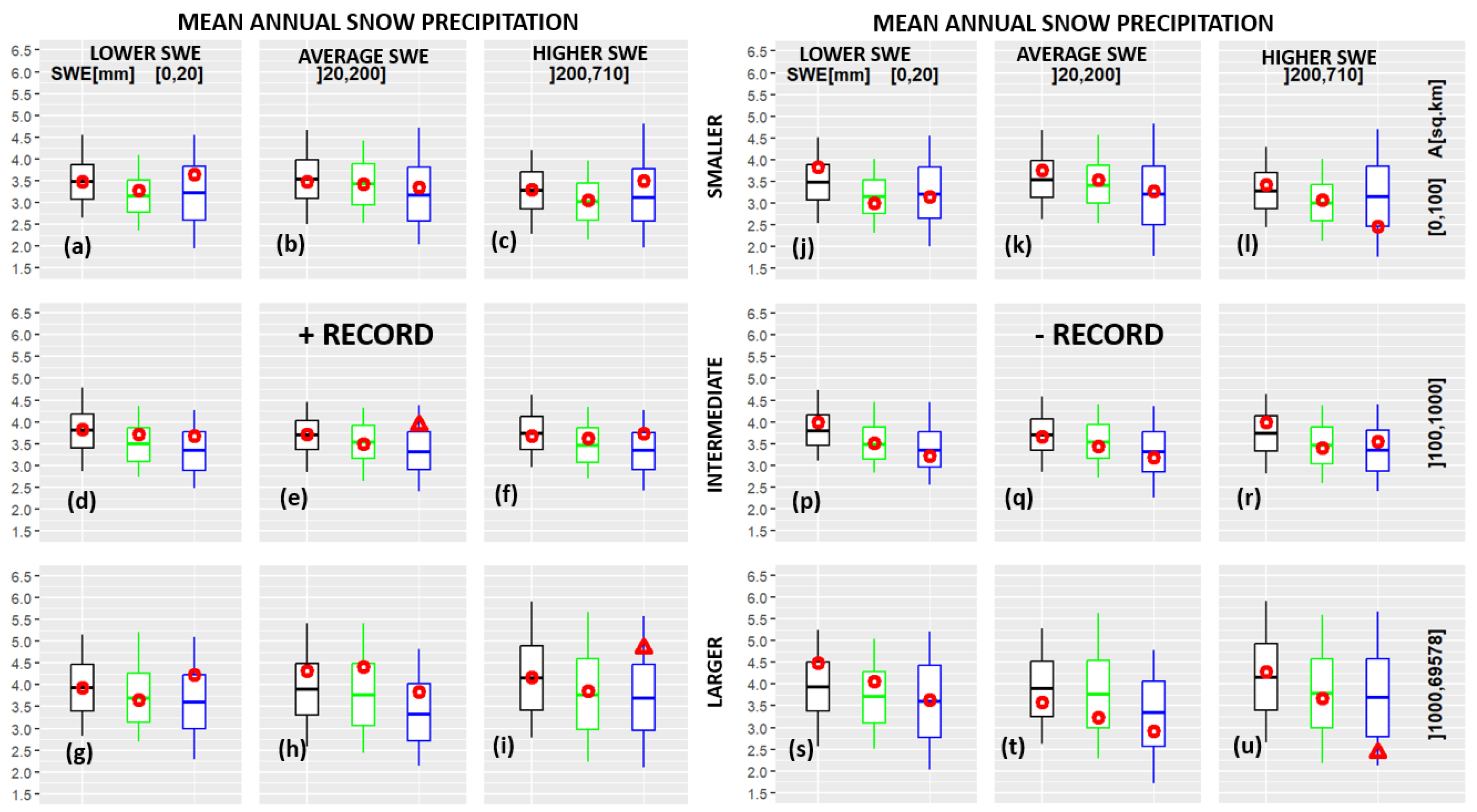
For each single pooling-group, the distribution of NRbin is computed using a bootstrap method, as described in Section 2.3. This distribution essentially reproduces the natural variability of the NRbin in the iid sequences, and is represented via boxplots in Figure 5, Figure 6, Figure 7 and Figure 8. The NRbin computed using the original time series is represented as a red circle for each pooling-group and each time interval. In cases where NRbin falls outside the confidence interval for iid sequences, a red triangle is adopted.
The number of records is significantly different from that in the iid hypothesis (i.e., red dots outside the confidence interval of 5–95% of the boxplot) in several cases. Regarding the first hydrological criterion (i.e., catchment area and mean annual precipitation), six cases are evident. The number of higher records shows an increase during the 1971–2020 time interval for intermediate- and large-sized catchments with low (Figure 5d,g) and intermediate MAP (Figure 5e,h). The lower records show an increase for the whole 1911–2020 time interval in drier intermediate catchments (Figure 5p), and a decrease for the 1971–2020 time interval in smaller catchments with intermediate MAP (Figure 5k).
Regarding the second criterion (i.e., catchment area and mean annual snow precipitation), three cases of significant non-stationarity are observed. The higher records exhibit an increase during the 1971–2020 time interval for intermediate-sized catchments with average snow precipitation (Figure 6e) and larger-sized catchments with higher SWE (Figure 6i). In the same time interval, larger-sized catchments with higher SWE also show a significant decrease in the occurrence of lower records (Figure 6u).
Regarding the third hydrological criterion (i.e., catchment area and outlet elevation), four cases of significant non-stationarity are observed. The +records show an increase during the 1971–2020 time interval in intermediate sized catchments with lower (Figure 7d) and higher (Figure 7f) ME, as well as in large catchments with average ME (Figure 7h).
Regarding the fourth hydrological criterion (i.e., catchment area and centroid’s latitude), higher records exhibit an increase in non-stationary occurrence for all catchments with central latitude (Figure 8b,e,h).

3.2. Pooling-Groups of Spatially Close Catchments

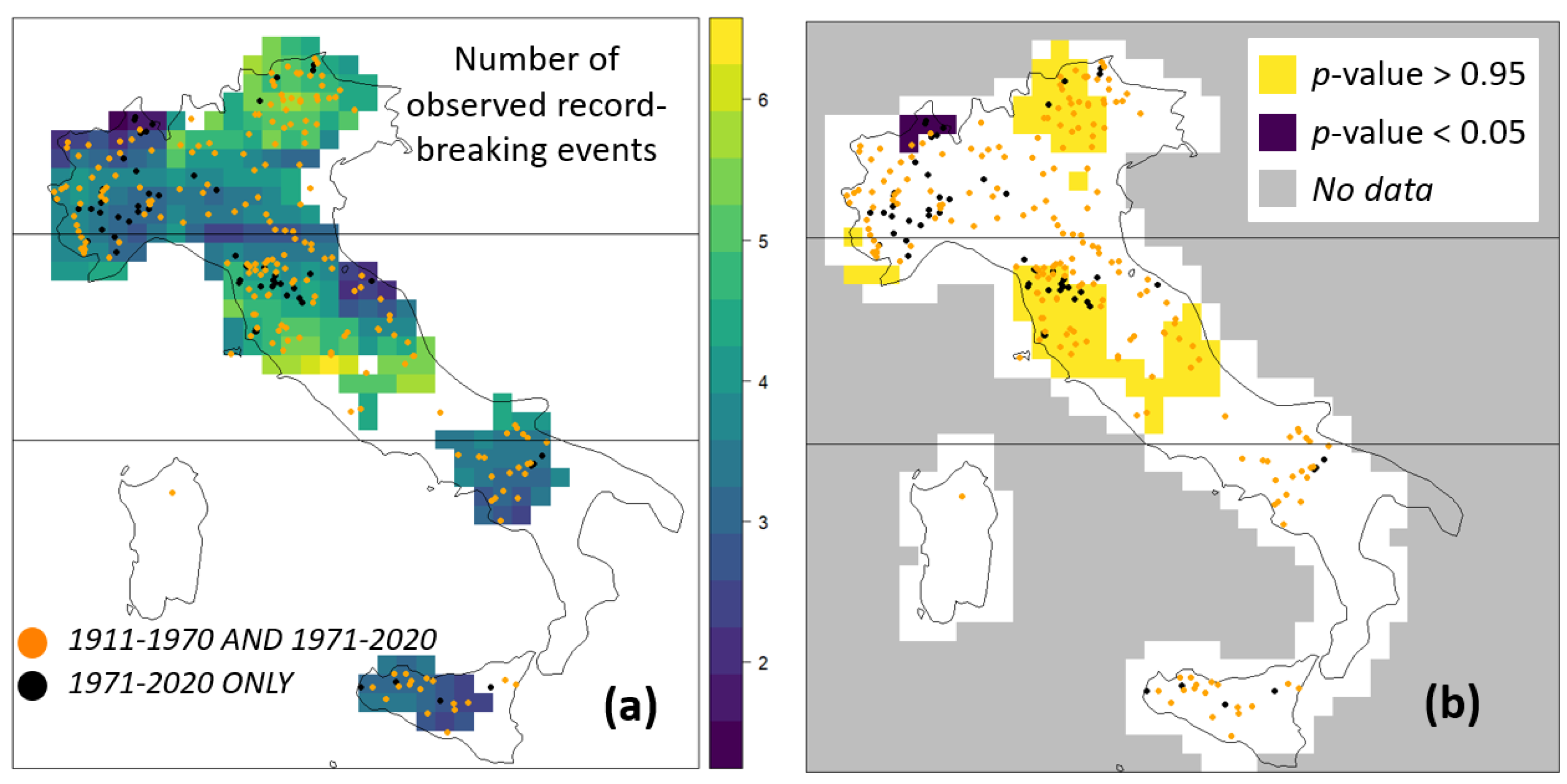
Figure 9 and Figure 10 show the average number of records and the statistical significance of the deviation from what would be expected under the iid hypothesis for +records and -records, respectively, with a 90 × 90 km spatial discretization of the study area (see Section 2.3). They refer to the empirical p-value, i.e., empirical non-exceedance probability of the average number of record events in each tile relative to the distribution of the synthetic average number of records resulting from the 10,000 bootstrap realizations. Specifically, only tiles containing at least five stations are showed. Figure 9 and Figure 10 refer to the last 50 years, while the results we obtained relative to the time periods 1911–2020 and 1911–1970 (not shown here for the sake of brevity) show statistically significant deviations from the iid hypothesis regarding the regional number of +record or −record events only in small areas and isolated pixels, if any.
Clear and spatially coherent geographical patterns are visible. For example, we detect an intensification in the frequency of record-breaking flood events in central and north-eastern (i.e., Triveneto) Italy (Figure 9). In these areas, +record events are significantly more frequent than what is expected under the iid hypothesis, while −records are less frequent than expected for iid sequences (Figure 10). Also, -record events show a higher frequency than for iid sequences in southern Italy, particularly for stream basins with river mouths originating in the Adriatic Sea.

4. Discussion

The presented results show that if we consider the entire available period (1911–2020) or the period of 1911–1970, the empirical average numbers of record events (both +record and −record) do not show significant deviations from the iid hypothesis, with a few exceptions. In particular, regional numbers of −record events present few, but consistent, significant deviations in the time period of 1911–2020 in smaller and intermediate catchments (Figure 5p, Figure 7k and Figure 8j), which may be linked to a decrease in the magnitude of flood events over time.
Differently, in the last 50 years, statistically significant deviations from what would be expected under the iid hypothesis have been found for pooling-groups of catchments. Specifically, when considering pooling-groups that are identified based on hydrological similarity, +records show a larger number of deviations (Figure 5d,e,g,h, Figure 6e,i, Figure 7d,f,h and Figure 8b,e,h) relative to those of the −records (Figure 5k and Figure 6u). It is interesting to note that the behavior observed for +record events is in agreement with that of -record events (e.g., an increase in time of the frequency of +record events is coupled with a decrease in the frequency of -record events; the overall magnitude of annual maximum floods is increasing in time) in two cases. This happens for larger catchments with high SWE (see Figure 6i,u, for +records and −records, respectively) and for pooling-groups of sites (i.e., tiles) in northeastern Italy (see Figure 9b and Figure 10b).
Regarding the hydrological subdivision of the available catchments, the alterations we detected vary among homogeneous groups, as in some classes, we observe an increase in the number of record-breaking floods, while a statistically significant decrease can be observed in others.
Interestingly, the catchment area does not show a direct and interpretable link with the alterations. Other descriptors appear to have a more structured influence on the number of records. As an example, during the last 50 years, catchments with lower MAP (mostly located in the central southern Italy, see Figure 2b) tend to show more statistically significant deviations in the frequency of record-breaking events relative to what would be expected for a stationary annual maximum series (Figure 5). This may be due to the fact that basins with higher MAP, located in the north and at high elevations in the central Italy, can exhibit opposite non-stationarities (see Figure 9 and Figure 10); thus, aggregating by means of MAP only can hide local signals. Differently, larger catchments with high SWE, which could describe the northeast basins, exhibit significant non-stationarity (Figure 6, Figure 9 and Figure 10).
Notably, these observations are in line with the work of Ref. [9]; this study detected a flood-rich period in northern Italy over the last decades. Positive trends of flood quantiles showed in Ref. [55] are in agreement with the increase in +record occurrence in the northeast (Figure 10b). The increase in −records in the south (Figure 10b) seems to be related to the negative trends observed over all of southern Europe [8,11,55]. However, the findings in Figure 9 and Figure 10 suggest that, when considering regional/national scales, more complex non-stationary patterns may arise with respect to continental scale studies that ignore smaller basins or shorter series. An interesting example is the non-stationarity signals in central Italy. This area was not marked as a flood change hot-spot in recent continental scale studies, most likely because of the lack of relevant information in such studies. Instead, the analysis framework we propose allows us to consider short time series, therefore increasing the spatial resolution of data coverage in the study area. Also, still concerning differences between our outcomes and those of existing studies, it is very important to underline once more the specific and novel perspective of our study, referring to the frequency of record-breaking events, which is markedly different from the approaches of most of the existing literature. Anomalies in the frequency of +records/−records are related to changes in very large/very small floods rather than to changes in the mean of flood frequency curves, which is usually considered with regression-based trend analyses.
It should be mentioned that a limitation of the present approach consists in the quality and quantity of the input data adopted within the study. In fact, the length and completeness of the time series employed for these analyses can strongly affect the recognition of spatial patterns and non-stationarity [53]. This is evident when looking at the availability of flood measurements for the 1971–2020 time interval in our study area (Figure 1a, Figure 9a and Figure 10a), which is concentrated in specific areas, mostly in central and northern Italy. A possible solution to this problem could be time series reconstruction [54,56,57]. However, the statistical properties of a synthetic time series would introduce strong and unreliable assumptions.
Nevertheless, studying the behavior of the number of records within the pooling-groups of catchments allows us to simultaneously consider a higher number of measured time series with a variable length, which increases the robustness of the results [17]. It is positive that significant alterations from the stationary case are not present wherever observations for 1971–2020 time interval are available, but only in specific areas (e.g., compare Figure 9a with Figure 9b and Figure 10a with Figure 10b). In fact, while all of northern and part of central Italy express a rather uniform data coverage over the last 50 years, statistically significant deviations are detected only for some sub-regions. Indeed, where data for the 1971–2020 time interval are sparse, the absence of statistically significant non-stationarity signals could be an artifact of data scarcity (see southern Italy, Figure 9 and Figure 10).
Generally, our findings are consistent across different pooling strategies (see the discussion above), and their agreement with those of previous studies can be taken as proof of their reliability. Future studies could investigate the drivers of floods and their temporal evolution, such as the presence of non-stationary behaviors in time sequences of extreme rainfall and frequencies of record-breaking rainstorms.

5. Conclusions

A large number of studies investigate the presence of non-stationary behaviors in the frequency and magnitude of peak flows at global [3,4] and continental scale [5,6,7]. Usually, the theory of extreme values and trend analysis is adopted. Differently, our work relates to the theory of records [29], and in particular, to the frequency of record-breaking events, which is a complementary perspective that might be very useful to improve our understanding regarding the frequency of extraordinarily intense events [30,40]. In particular, our study aims to assess the temporal and spatial evolution of the frequency of record-breaking flood events observed in Italy over the last century.
In our study, we define record-breaking events as the annual maximum floods that exceed, or are exceeded, by all other maxima that were previously observed for the same river cross-section. Our analysis considers 522 annual maximum series (AMS) of flood flows and based on the outcomes of some recent continental analysis of flood changes, refers to three distinct time intervals: 1911–2020, 1911–1971, and 1971–2020. For these three time periods, we compute the mean value of the number of record-breaking events in the pooling-groups of AMS identify based on hydrological affinity (expressed in terms of geomorphological and climatic descriptors) or geographical proximity of the corresponding catchments. Then, we compare the empirical values of the regional mean number of records with the average number of record events expected for groupings of iid AMS exhibiting the same characteristics, in terms of the number of available observations.
Our results show evident and statistically significant deviations in the frequency of record-breaking floods relative to what is expected under iid hypothesis. Stronger signals are associated with the last 50 years of observations, as observed in Ref. [11]. In particular, dryer catchments show an intensification in the magnitude of annual maximum floods in the last five decades, and hot spots of such an intensification can be found in Central and northeastern Italy. These outcomes are partially in agreement with the findings in recent studies at larger scales [8,9,11], but they also highlight the presence of previously unobserved patterns and hotspots of non-stationarity in flood frequency due to the finer scale and higher data coverage of our analyses. We believe that these concerning outcomes call for further investigations, particularly under the most sensitive climatic conditions and in the geographical areas identified in the study, as well as under similar morphological and climatic conditions found in the Alps, as well as in the Mediterranean Basin, to better assess the degree and extent of flood hazard intensification.

Author Contributions

Conceptualization, A.C. and F.C.; methodology, F.C., A.C. and R.M.V.; software, F.C.; validation, A.M. (Andrea Magnini), M.B., A.V., E.V. and G.B.; formal analysis, A.C.; investigation, F.C.; writing—original draft preparation, A.M. (Andrea Magnini) and A.C.; writing—review and editing, A.M. (Andrea Magnini), A.C., E.V., A.V., K.K.K., G.B., R.M.V., P.C. and A.M. (Alberto Marinelli); visualization, A.C., F.C. and A.M. (Andrea Magnini); supervision, A.C. All authors have read and agreed to the published version of the manuscript.

Funding

This research received no external funding.

Institutional Review Board Statement

Not applicable.

Informed Consent Statement

Not applicable.

Data Availability Statement

The flood date data used in this paper can be downloaded at https://github.com/tuwhydro/europe_floods (accessed on 17 July 2024). The DEM adopted for retrieving the descriptors (i.e., MERIT DEM, see [43]) can be downloaded free of charge at http://hydro.iis.u-tokyo.ac.jp/~yamadai/MERIT_DEM/ (accessed on 17 July 2024). The raster files representing the mean cumulate annual liquid and snow precipitation are freely provided by the Italian Institute for Environmental Protection and Research (ISPRA, see [45]) at the website https://www.isprambiente.gov.it/pre_meteo/idro/BIGBANG_ISPRA.html (accessed on 17 July 2024).

Acknowledgments

The reviewers’ comments and suggestions associated with our original submission are thankfully acknowledged.

Conflicts of Interest

The authors declare no conflicts of interest.

References

  1. Jongman, B.; Koks, E.E.; Husby, T.G.; Ward, P.J. Increasing Flood Exposure in the Netherlands: Implications for Risk Financing. Nat. Hazards Earth Syst. Sci. 2014, 14, 1245–1255. [Google Scholar] [CrossRef]
  2. Guha-Sapir, D.; Hoyois, P.; Wallemacq, P.; Below, R. Annual Disaster Statistical Review 2016: The Numbers and Trends; Centre for Research on the Epidemiology of Disasters: Brussels, Belgium, 2016. [Google Scholar]
  3. Hirabayashi, Y.; Mahendran, R.; Koirala, S.; Konoshima, L.; Yamazaki, D.; Watanabe, S.; Kim, H.; Kanae, S. Global Flood Risk under Climate Change. Nat. Clim. Chang. 2013, 3, 816–821. [Google Scholar] [CrossRef]
  4. Do, H.X.; Westra, S.; Leonard, M. A Global-Scale Investigation of Trends in Annual Maximum Streamflow. J. Hydrol. 2017, 552, 28–43. [Google Scholar] [CrossRef]
  5. Alfieri, L.; Burek, P.; Feyen, L.; Forzieri, G. Global Warming Increases the Frequency of River Floods in Europe. Hydrol. Earth Syst. Sci. 2015, 19, 2247–2260. [Google Scholar] [CrossRef]
  6. Mediero, L.; Kjeldsen, T.R.; Macdonald, N.; Kohnova, S.; Merz, B.; Vorogushyn, S.; Wilson, D.; Alburquerque, T.; Blöschl, G.; Bogdanowicz, E.; et al. Identification of Coherent Flood Regions across Europe by Using the Longest Streamflow Records. J. Hydrol. 2015, 528, 341–360. [Google Scholar] [CrossRef]
  7. Berghuijs, W.R.; Aalbers, E.E.; Larsen, J.R.; Trancoso, R.; Woods, R.A. Recent Changes in Extreme Floods across Multiple Continents. Environ. Res. Lett. 2017, 12, 114035. [Google Scholar] [CrossRef]
  8. Bertola, M.; Viglione, A.; Vorogushyn, S.; Lun, D.; Merz, B.; Blöschl, G. Do Small and Large Floods Have the Same Drivers of Change? A Regional Attribution Analysis in Europe. Hydrol. Earth Syst. Sci. 2021, 25, 1347–1364. [Google Scholar] [CrossRef]
  9. Blöschl, G.; Kiss, A.; Viglione, A.; Barriendos, M.; Böhm, O.; Brázdil, R.; Coeur, D.; Demarée, G.; Llasat, M.C.; Macdonald, N.; et al. Current European Flood-Rich Period Exceptional Compared with Past 500 Years. Nature 2020, 583, 560–566. [Google Scholar] [CrossRef] [PubMed]
  10. Blöschl, G.; Hall, J.; Parajka, J.; Perdigão, R.A.P.; Merz, B.; Arheimer, B.; Aronica, G.T.; Bilibashi, A.; Bonacci, O.; Borga, M.; et al. Changing Climate Shifts Timing of European Floods. Science 2017, 357, 588–590. [Google Scholar] [CrossRef]
  11. Blöschl, G.; Hall, J.; Viglione, A.; Perdigão, R.A.P.; Parajka, J.; Merz, B.; Lun, D.; Arheimer, B.; Aronica, G.T.; Bilibashi, A.; et al. Changing Climate Both Increases and Decreases European River Floods. Nature 2019, 573, 108–111. [Google Scholar] [CrossRef]
  12. Venegas-Cordero, N.; Kundzewicz, Z.W.; Jamro, S.; Piniewski, M. Detection of Trends in Observed River Floods in Poland. J. Hydrol. Reg. Stud. 2022, 41, 101098. [Google Scholar] [CrossRef]
  13. Lintunen, K.; Kasvi, E.; Uvo, C.B.; Alho, P. Changes in the Discharge Regime of Finnish Rivers. J. Hydrol. Reg. Stud. 2024, 53, 101749. [Google Scholar] [CrossRef]
  14. Slater, L.J.; Villarini, G. Recent Trends in U.S. Flood Risk. Geophys. Res. Lett. 2016, 43, 12428–12436. [Google Scholar] [CrossRef]
  15. Tramblay, Y.; Mimeau, L.; Neppel, L.; Vinet, F.; Sauquet, E. Detection and Attribution of Flood Trends in Mediterranean Basins. Hydrol. Earth Syst. Sci. 2019, 23, 4419–4431. [Google Scholar] [CrossRef]
  16. Kay, A.L.; Crooks, S.M.; Davies, H.N.; Prudhomme, C.; Reynard, N.S. Probabilistic Impacts of Climate Change on Flood Frequency Using Response Surfaces I: England and Wales. Reg. Environ. Chang. 2014, 14, 1215–1227. [Google Scholar] [CrossRef]
  17. Prosdocimi, I.; Dupont, E.; Augustin, N.H.; Kjeldsen, T.R.; Simpson, D.P.; Smith, T.R. Areal Models for Spatially Coherent Trend Detection: The Case of British Peak River Flows. Geophys. Res. Lett. 2019, 46, 13054–13061. [Google Scholar] [CrossRef]
  18. Renard, B.; Lang, M.; Bois, P.; Dupeyrat, A.; Mestre, O.; Niel, H.; Sauquet, E.; Prudhomme, C.; Parey, S.; Paquet, E.; et al. Regional Methods for Trend Detection: Assessing Field Significance and Regional Consistency. Water Resour. Res. 2008, 44, 2007WR006268. [Google Scholar] [CrossRef]
  19. Nerantzaki, S.D.; Papalexiou, S.M. Assessing Extremes in Hydroclimatology: A Review on Probabilistic Methods. J. Hydrol. 2022, 605, 127302. [Google Scholar] [CrossRef]
  20. Ouarda, T.B.M.J.; Charron, C. Changes in the Distribution of Hydro-Climatic Extremes in a Non-Stationary Framework. Sci. Rep. 2019, 9, 8104. [Google Scholar] [CrossRef]
  21. Fischer, S.; Schumann, A.; Bühler, P. Timescale-Based Flood Typing to Estimate Temporal Changes in Flood Frequencies. Hydrol. Sci. J. 2019, 64, 1867–1892. [Google Scholar] [CrossRef]
  22. Hesarkazzazi, S.; Arabzadeh, R.; Hajibabaei, M.; Rauch, W.; Kjeldsen, T.R.; Prosdocimi, I.; Castellarin, A.; Sitzenfrei, R. Stationary vs. Non-Stationary Modelling of Flood Frequency Distribution across Northwest England. Hydrol. Sci. J. 2021, 66, 729–744. [Google Scholar] [CrossRef]
  23. Coles, S. An Introduction to Statistical Modeling of Extreme Values; Springer series in statistics; Springer: London, UK; New York, NY, USA, 2001; ISBN 978-1-85233-459-8. [Google Scholar]
  24. Wei, W.W.S. Time Series Analysis: Univariate and Multivariate Methods, 2nd ed.; Pearson Addison Wesley: Boston, MA, USA, 2006; ISBN 978-0-321-32216-6. [Google Scholar]
  25. Dalrymple, T. Flood-Frequency Analyses, Manual of Hydrology: Part 3; U.S. Geological Survey Water Supply Paper; United States Government Printing Office: Washington, DC, USA, 1960. [Google Scholar]
  26. Kendall, M.; Gibbons, J.D. Rank Correlation Methods: A Charles Griffin Title, 5th ed.; E. Arnold: London, UK; Melbourne, Australia; Auckland, New Zealand, 1990; ISBN 978-0-85264-305-1. [Google Scholar]
  27. Koutsoyiannis, D. Statistics of Extremes and Estimation of Extreme Rainfall: II. Empirical Investigation of Long Rainfall Records/Statistiques de Valeurs Extrêmes et Estimation de Précipitations Extrêmes: II. Recherche Empirique Sur de Longues Séries de Précipitations. Hydrol. Sci. J. 2004, 49, 4. [Google Scholar] [CrossRef]
  28. Papalexiou, S.M.; Koutsoyiannis, D. Battle of Extreme Value Distributions: A Global Survey on Extreme Daily Rainfall. Water Resour. Res. 2013, 49, 187–201. [Google Scholar] [CrossRef]
  29. Arnold, B.C.; Balakrishnan, N.; Nagaraja, H.N. Records, 1st ed.; Wiley Series in Probability and Statistics; Wiley: Hoboken, NJ, USA, 1998; ISBN 978-0-471-08108-1. [Google Scholar]
  30. Vogel, R.M.; Zafirakou-Koulouris, A.; Matalas, N.C. Frequency of Record-breaking Floods in the United States. Water Resour. Res. 2001, 37, 1723–1731. [Google Scholar] [CrossRef]
  31. Vogel, R.M.; Matalas, N.C.; Castellarin, A.; England, J.F. Hydrologic Record Events. In Statistical Analysis of Hydrologic Variables: Methods and Applications; American Society of Civil Engineers: Reston, VG, USA, 2019; ISBN 9780784415177. [Google Scholar]
  32. Sena, E.T.; Koren, I.; Altaratz, O.; Kostinski, A.B. Record-Breaking Statistics Detect Islands of Cooling in a Sea of Warming. Atmos. Chem. Phys. 2022, 22, 16111–16122. [Google Scholar] [CrossRef]
  33. Belleri, L.; Ciarlo, J.M.; Maugeri, M.; Ranzi, R.; Giorgi, F. Continental-scale Trends of Daily Precipitation Records in Late 20th Century Decades and 21st Century Projections: An Analysis of Observations, Reanalyses and CORDEX-CORE Projections. Int. J. Climatol. 2023, 43, 7003–7017. [Google Scholar] [CrossRef]
  34. Serinaldi, F.; Kilsby, C.G. Unsurprising Surprises: The Frequency of Record-breaking and Overthreshold Hydrological Extremes Under Spatial and Temporal Dependence. Water Resour. Res. 2018, 54, 6460–6487. [Google Scholar] [CrossRef]
  35. Van Aalsburg, J.; Newman, W.I.; Turcotte, D.L.; Rundle, J.B. Record-Breaking Earthquakes. Bull. Seismol. Soc. Am. 2010, 100, 1800–1805. [Google Scholar] [CrossRef]
  36. Gembris, D.; Taylor, J.G.; Suter, D. Evolution of Athletic Records: Statistical Effects versus Real Improvements. J. Appl. Stat. 2007, 34, 529–545. [Google Scholar] [CrossRef]
  37. Orr, H.A. The Genetic Theory of Adaptation: A Brief History. Nat. Rev. Genet. 2005, 6, 119–127. [Google Scholar] [CrossRef]
  38. Wergen, G. Records in Stochastic Processes—Theory and Applications. J. Phys. A Math. Theor. 2013, 46, 223001. [Google Scholar] [CrossRef]
  39. Castillo-Mateo, J.; Cebrián, A.C.; Asín, J. Record Test: An R Package to Analyze Non-Stationarity in the Extremes Based on Record-Breaking Events. J. Stat. Soft. 2023, 106, 1–28. [Google Scholar] [CrossRef]
  40. St. George, S.; Mudelsee, M. The Weight of the Flood-of-record in Flood Frequency Analysis. J. Flood Risk Manag. 2019, 12, e12512. [Google Scholar] [CrossRef]
  41. Claps, P.; Evangelista, G.; Ganora, D.; Mazzoglio, P.; Monforte, I. FOCA: A new quality-controlled database of floods and catchment descriptors in Italy. Earth Syst. Sci. Data 2024, 16, 1503–1522. [Google Scholar]
  42. Lun, D.; Fischer, S.; Viglione, A.; Blöschl, G. Detecting Flood-Rich and Flood-Poor Periods in Annual Peak Discharges Across Europe. Water Resour. Res. 2020, 56, e2019WR026575. [Google Scholar] [CrossRef] [PubMed]
  43. Yamazaki, D.; Ikeshima, D.; Tawatari, R.; Yamaguchi, T.; O’Loughlin, F.; Neal, J.C.; Sampson, C.C.; Kanae, S.; Bates, P.D. A High-Accuracy Map of Global Terrain Elevations: Accurate Global Terrain Elevation Map. Geophys. Res. Lett. 2017, 44, 5844–5853. [Google Scholar] [CrossRef]
  44. Yamazaki, D.; Ikeshima, D.; Sosa, J.; Bates, P.D.; Allen, G.H.; Pavelsky, T.M. MERIT Hydro: A High-Resolution Global Hydrography Map Based on Latest Topography Dataset. Water Resour. Res. 2019, 55, 5053–5073. [Google Scholar] [CrossRef]
  45. Braca, G.; Bussettini, M.; Lastoria, B.; Mariani, S.; Piva, F. Il Modello Di Bilancio Idrologico Nazionale 395 BIGBANG: Sviluppo e Applicazioni Operative. La Disponibilità Della Risorsa Idrica Naturale in Italia Dal 1951 al 396 2020/The BIGBANG National Water Balance Model: Development and Operational Applications. The 397 Availability of Renewable Freshwater Resources in Italy from 1951 to 2020. L’Acqua 2022, 2, 13. [Google Scholar]
  46. Merz, R.; Tarasova, L.; Basso, S. The Flood Cooking Book: Ingredients and Regional Flavors of Floods across Germany. Environ. Res. Lett. 2020, 15, 114024. [Google Scholar] [CrossRef]
  47. Ssegane, H.; Tollner, E.W.; Mohamoud, Y.M.; Rasmussen, T.C.; Dowd, J.F. Advances in Variable Selection Methods I: Causal Selection Methods versus Stepwise Regression and Principal Component Analysis on Data of Known and Unknown Functional Relationships. J. Hydrol. 2012, 438–439, 16–25. [Google Scholar] [CrossRef]
  48. Tarasova, L.; Gnann, S.; Yang, S.; Hartmann, A.; Wagener, T. Catchment Characterization: Current Descriptors, Knowledge Gaps and Future Opportunities. Earth-Sci. Rev. 2024, 252, 104739. [Google Scholar] [CrossRef]
  49. Castellarin, A.; Vogel, R.M.; Matalas, N.C. Probabilistic Behavior of a Regional Envelope Curve. Water Resour. Res. 2005, 41, 2004WR003042. [Google Scholar] [CrossRef]
  50. Efron, B.; Tibshirani, R.J. An Introduction to the Bootstrap, 1st ed.; Chapman and Hall/CRC: Boca Raton, FL, USA, 1994; ISBN 978-0-429-24659-3. [Google Scholar]
  51. Castellarin, A. Probabilistic Envelope Curves for Design Flood Estimation at Ungauged Sites. Water Resour. Res. 2007, 43, 2005WR004384. [Google Scholar] [CrossRef]
  52. Castellarin, A.; Burn, D.H.; Brath, A. Homogeneity Testing: How Homogeneous Do Heterogeneous Cross-Correlated Regions Seem? J. Hydrol. 2008, 360, 67–76. [Google Scholar] [CrossRef]
  53. Libertino, A.; Ganora, D.; Claps, P. Evidence for Increasing Rainfall Extremes Remains Elusive at Large Spatial Scales: The Case of Italy. Geophys. Res. Lett. 2019, 46, 7437–7446. [Google Scholar] [CrossRef]
  54. Libertino, A.; Allamano, P.; Laio, F.; Claps, P. Regional-Scale Analysis of Extreme Precipitation from Short and Fragmented Records. Adv. Water Resour. 2018, 112, 147–159. [Google Scholar] [CrossRef]
  55. Bertola, M.; Viglione, A.; Lun, D.; Hall, J.; Blöschl, G. Flood Trends in Europe: Are Changes in Small and Big Floods Different? Hydrol. Earth Syst. Sci. 2020, 24, 1805–1822. [Google Scholar] [CrossRef]
  56. Chapon, A.; Ouarda, T.B.M.J.; Hamdi, Y. Imputation of Missing Values in Environmental Time Series by D-Vine Copulas. Weather. Clim. Extrem. 2023, 41, 100591. [Google Scholar] [CrossRef]
  57. Wang, L.-P.; Dai, T.-Y.; He, Y.-T.; Chou, C.-C.; Onof, C. pyBL: An Open Source Python Package for Stochastic High-Resolution Rainfall Modelling Based upon a Bartlett Lewis Rectangular Pulse Model 2021. In Proceedings of the EGU General Assembly 2021, Online, 19–30 April 2021. [Google Scholar]
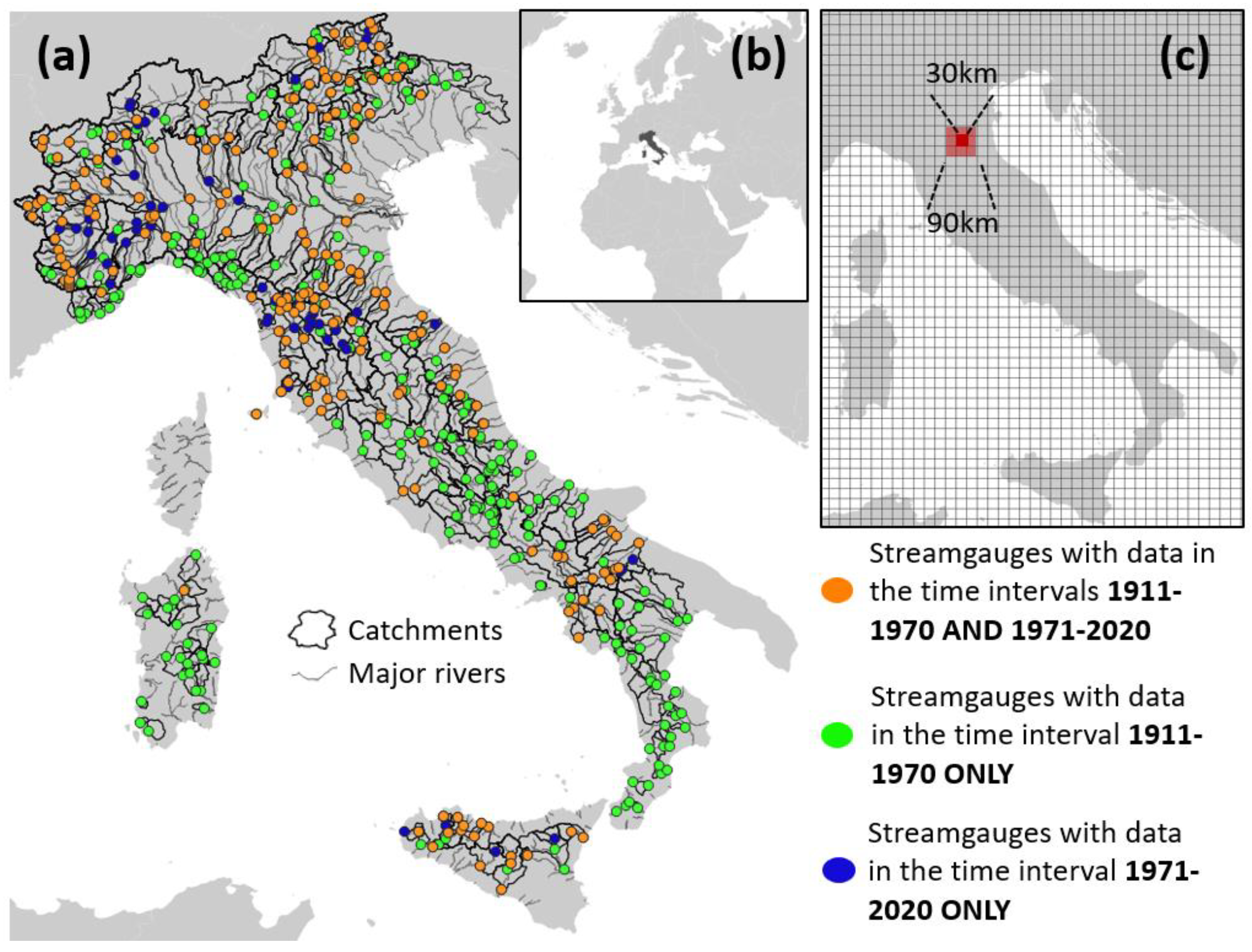
Figure 1. Study area and basins (a); location of study area (b); discretization of the study area into 90 × 90 km and 30 × 30 km tiles (c).
Atmosphere 15 00865 g001
Figure 2. Elevation (DEM, panel (a)), mean annual total precipitation (MAP, (b)), and mean annual snow water equivalent (SWE, (c)) in the study area. In red, the catchments considered in the study.
Atmosphere 15 00865 g002
Figure 3. Expected number of record-breaking events (R) in an iid series of given length (with 2.5th and 97.5th percentiles). The mean is obtained from Equation (1). Percentiles are obtained from Monte Carlo simulations by generating 1000 synthetic iid sequences.
Atmosphere 15 00865 g003
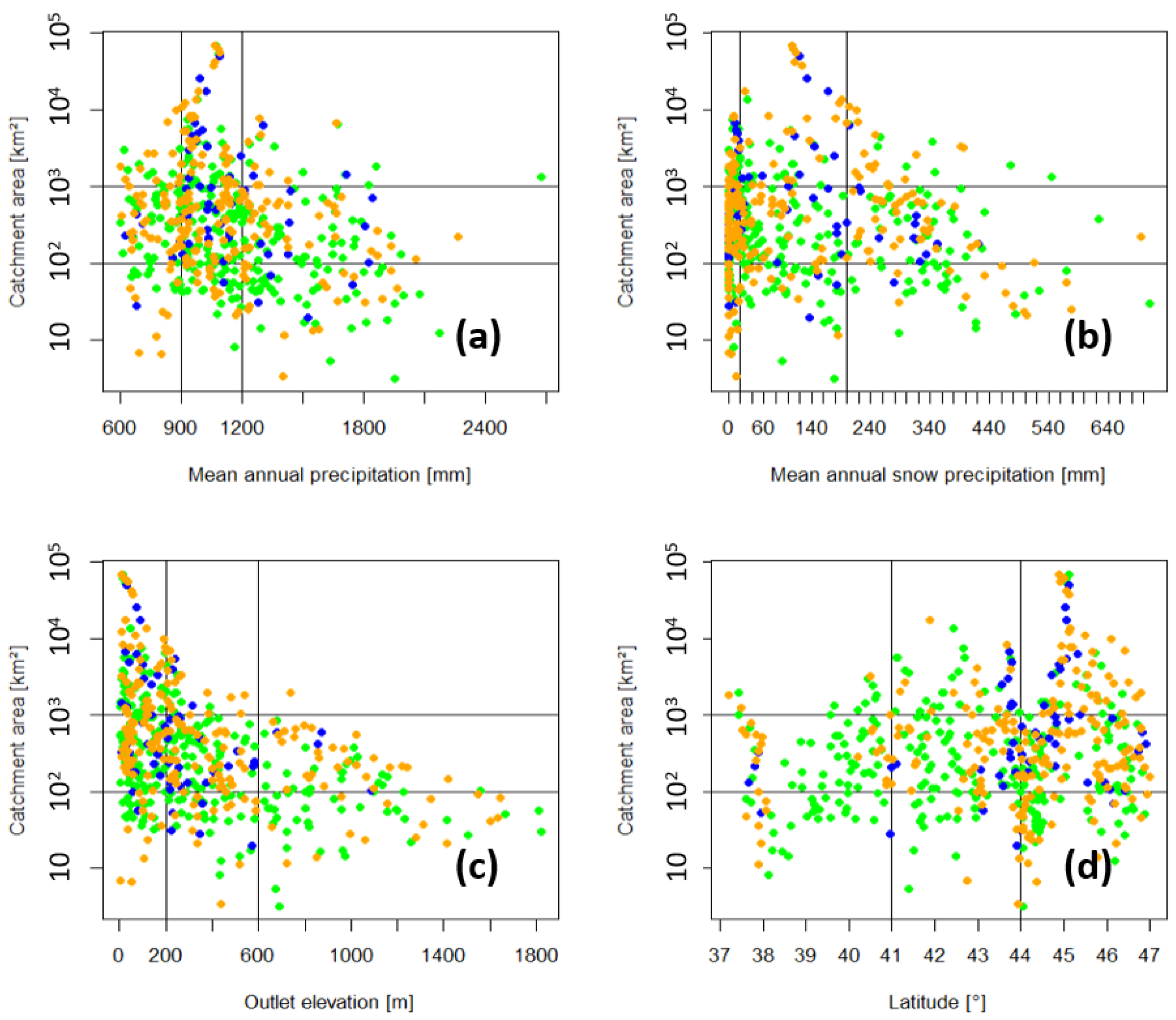
Figure 4. Size (y axis) and other descriptors (x axis) of the study area: mean annual precipitation (a), mean annual snow precipitation (b), outlet elevation (c), latitude of catchment centroid (d). Colors of the dots follows the legend of Figure 1.
Atmosphere 15 00865 g004
Figure 5. Average number of +(panels (ai)) and −(panels (jl,pu)) records for hydrologically similar catchments. The pooling descriptors include catchment area (y axis) and mean annual precipitation (MAP, x axis). Values for the boxplots are obtained through bootstrap experiments; a red circle represents the average number of records for each pooling-group. Average numbers of records falling outside the confidence interval are marked with red triangles.
Atmosphere 15 00865 g005
Figure 6. Average number of +(panels (ai)) and −(panels (jl,pu)) records for hydrologically similar catchments. The pooling descriptors include catchment area (y axis) and mean annual snow water equivalent (SWE, x axis). Values for the boxplots are obtained through bootstrap experiments; red circles represent the average number of records for each pooling-group. Average numbers of records falling outside the confidence interval are marked with red triangles. Also see the legend in Figure 5.
Atmosphere 15 00865 g006
Figure 7. Average number of +(panels (ai)) and −(panels (jl,pu)) records for hydrologically similar catchments. The pooling descriptors include catchment area (y axis) and minimum elevation (ME, or outlet elevation, x axis). Values for the boxplots are obtained through bootstrap experiments; red circles represent the average number of records for each pooling-group. Average numbers of records falling outside the confidence interval are marked with red triangles. Also see the legend in Figure 5.
Atmosphere 15 00865 g007
Figure 8. Average number of +(panels (ai)) and −(panels (jl,pu)) records for hydrologically similar catchments. The pooling descriptors include catchment area (y axis) and latitude of the catchment’s centroid (LC, x axis). Values for the boxplots are obtained through bootstrap experiments; red dots represent the average number of records for each pooling-group. Average numbers of records falling outside the confidence interval are marked with red triangles. Also see the legend in Figure 5.
Atmosphere 15 00865 g008
Figure 9. Spatial analysis of the average number of +record events and its statistical significance (10% significance level) relative to pooling-groups of iid series having the same length and spatial correlation as the original sample: (a) average number of +records (see color scale); (b) tiles for which the average number of record events is associated with p-values > 0.95 or <0.05 under the iid hypothesis.
Atmosphere 15 00865 g009
Figure 10. Spatial analysis of the regional average number of −record events and its statistical significance (10% significance level) relative to pooling-groups of iid series having the same length and spatial correlation as the original sample: (a) average number of −records (see color scale); (b) tiles for which the average number of record events is associated with p-values > 0.95 or <0.05 under the iid hypothesis.
Atmosphere 15 00865 g010
Table 1. Record length statistics for the annual maximum series (AMS) of the study for the flood flows in the three different time intervals considered the analyses.
1971–20201911–19701911–2020Time Interval
263464522AMS
19.421.528.9Average record length (years)
181923Median record length (years)
495359Maximum record length (years)
Disclaimer/Publisher’s Note: The statements, opinions and data contained in all publications are solely those of the individual author(s) and contributor(s) and not of MDPI and/or the editor(s). MDPI and/or the editor(s) disclaim responsibility for any injury to people or property resulting from any ideas, methods, instructions or products referred to in the content.