Abstract
The impact of antecedent soil moisture content on soil erosion has been a contradictory issue in erosion research, as well as process-based soil loss estimation models. The objective of this study was to investigate the impact of antecedent soil moisture content on the loss of clay soil through two-year runoff plot experiments under natural rainfall. Volumetric soil moisture sensors were used to monitor soil moisture changes, and readings were used along with rainfall records to quantify the antecedent soil moisture conditions. The results of this study show that the impact of antecedent soil moisture on interrill erosion is conditional, and the impact only exists in erosion events with a low Rainfall–Runoff Erosivity Index. The coefficient of determination between antecedent soil moisture content and soil loss per the Rainfall–Runoff Erosivity Index (Soil Loss/EI30) varies from 0.222 to 0.758, depending on the rainfall duration and Rainfall–Runoff Erosivity. The results of this study also suggest that accumulative rainfall within 48 h (Pp48) prior to an effective erosion event is strongly correlated with Soil Loss/EI30, particularly when the duration of an effective erosion event is either 3~7 h or 10~30 h. Hence, Pp48 can be considered as a replacement for antecedent soil moisture in process-based soil loss simulation models.
1. Introduction
Soil erosion is one of the natural processes that shape the landscape through the action of water and wind. It causes environmental impacts such as (1) non-point source pollution resulting from eroded soil carrying pollutants from hillslopes, (2) a reduction in soil fertility that affects crop yield, and (3) sedimentation in rivers and water bodies [1,2,3,4,5]. Hence, the quantification of soil loss has received much research attention, and the techniques for soil loss estimation have changed from parametrized estimations such as USLE [6,7] and RUSLE [8] to processes-based simulations, for instance, CREAMS [9], AgNPS [10], WEPP [11,12], and SWAT [13]. Regardless of the simplicity or complexity of models, soil loss estimation is still based on the existing understanding of soil erosion processes.
The physical and chemical properties of soil are determined during its formation through weathering, transport, deposition, and consolidation, among other geological processes [14]. However, soil improvement and human interventions, namely, land grading, cover and crop management, and soil conservation, can alter soil erodibility [5,15]. Putting this into Universal Soil Loss Equation (USLE) terminology, these interventions are parameterized as the slope length factor (L), slope steepness factor (S), cover and management factor (C), and conservation factor (P), respectively, among which, the C factor is probably the most complicated parameter.
The C factor has gone through development and revision for almost half a century. It has advanced from the original concept of USLE, namely, C = Cc × Cs, which considers the contributions from the vegetation canopy and surface mulch, to RSUEL Version 2 (USDA-ARS, 2013), namely, C = Cc × gc × Sr × rh × Sb × Sc × Pp × am, which considers the effects of the canopy and ground cover, random and artificial surface roughness, soil biomass, soil consolidation, ponding, and antecedent soil moisture content.
The soil moisture content changes soil physical properties such as shear strength and cohesion, thereby altering soil resistance to erosion [16,17]. A positive correlation has been found between soil moisture content and surface runoff [18,19,20,21]. Fortesa et al. (2020) [22] analyzed 5-year soil moisture and flow data at the Es Fangar catchment in Mallorca, Spain (Western Mediterranean Sea), and they found that 76% of flood events occurred under wet soil conditions. Massari et al. (2023) [23] analyzed data from the Global Runoff Data Center (GRDC) and the European Space Agency’s Climate Change Initiative (CCI), and they found that antecedent precipitation, soil moisture at the surface and in the root zone, pre-storm river discharge, and pre-storm total water storage all affect the scale of flood events significantly.
Jadidoleslam et al. (2019) [24] applied Soil Moisture Active/Passive (SMAP) to estimate the surface soil layer’s water contents for 38 watersheds (area ranged from 80 to 1000 km2) and correlated soil water content with runoff coefficients. They found that the runoff coefficients increased with an increase in the antecedent soil moisture content. In addition, the runoff coefficients changed significantly under humid conditions. Schoener et al. (2019) [25] observed surface runoff from watersheds at different scales (2.8 m2 and 2.8 km2), and the results also showed a positive correlation between the antecedent soil moisture content and runoff coefficient, regardless of the scale of the watershed. They also noted that antecedent soil moisture content affected surface runoff during small rainfall events but had less of an impact during heavy rainfall events.
While a positive correlation between antecedent soil moisture and soil erosion or runoff has been reported [26,27], there are studies that have suggested otherwise. For instance, Castillo et al. (2003) [28] conducted a field study using time-domain reflectometry (TDR) in three small semi-arid watersheds in eastern Spain with different vegetation characteristics. Numerical simulations were also carried out to study the correlation between antecedent soil moisture and surface runoff. They found that the impact of antecedent soil moisture on surface runoff depended on rainfall intensity and soil permeability. They concluded that surface runoff was not dependent on antecedent soil moisture content in the case of high-intensity rainfall or low-permeability soil; however, if low-intensity rainfall occurred on higher-permeability soil, surface runoff was controlled by the initial soil moisture content.
Truman and Bradford (1990) [29] conducted a series of experiments using a rainfall simulator to test the splash erosion rates on air-dried and prewetted soils, and the results indicated that a rise in soil moisture reduced the splash erosion rate, which might have been related to the promotion of soil sealing and aggregation stability [18,30]. Auerswald (1993) [31] indicated that increasing soil moisture from 10% to 30% reduced soil loss by 80%. Ma et al. (2014) [32] found a transition in the splash erosion rate during a rise in soil moisture content. The splash erosion rate initially decreased and then increased at a volumetric moisture threshold content of 15%.
Because of the contradictions in research results on the impact of antecedent soil moisture content on runoff and soil erosion, RUSLE2 includes the antecedent soil moisture content subfactor (am) in its C factor calculation as an option to reflect the impact of antecedent soil moisture content on erosion for dryland cropping in the Northwestern Wheat and Range Region (NWRR) and similar areas, where the amount of soil moisture from a prior crop affects erosion during the present crop. RUSLE2 also suggests ignoring the moisture depletion rate when implementing the model outside of the NWRR in the US.
If antecedent soil moisture content led to different opinions during the development of the RUSLE2 model and possibly other models, similar concerns will equally be raised at the users’ end. Therefore, the objectives of this study are (1) to investigate the correlation and possible explanations for the contradictions between antecedent soil moisture and interrill erosion and (2) to explore the feasibility of using rainfall parameters as alternatives to replace the impact of antecedent soil moisture to interrill erosion if impact from antecedent soil moisture content deserves consideration in soil loss estimation and modeling.
2. Materials and Methods
2.1. Experiment Site and Preparation
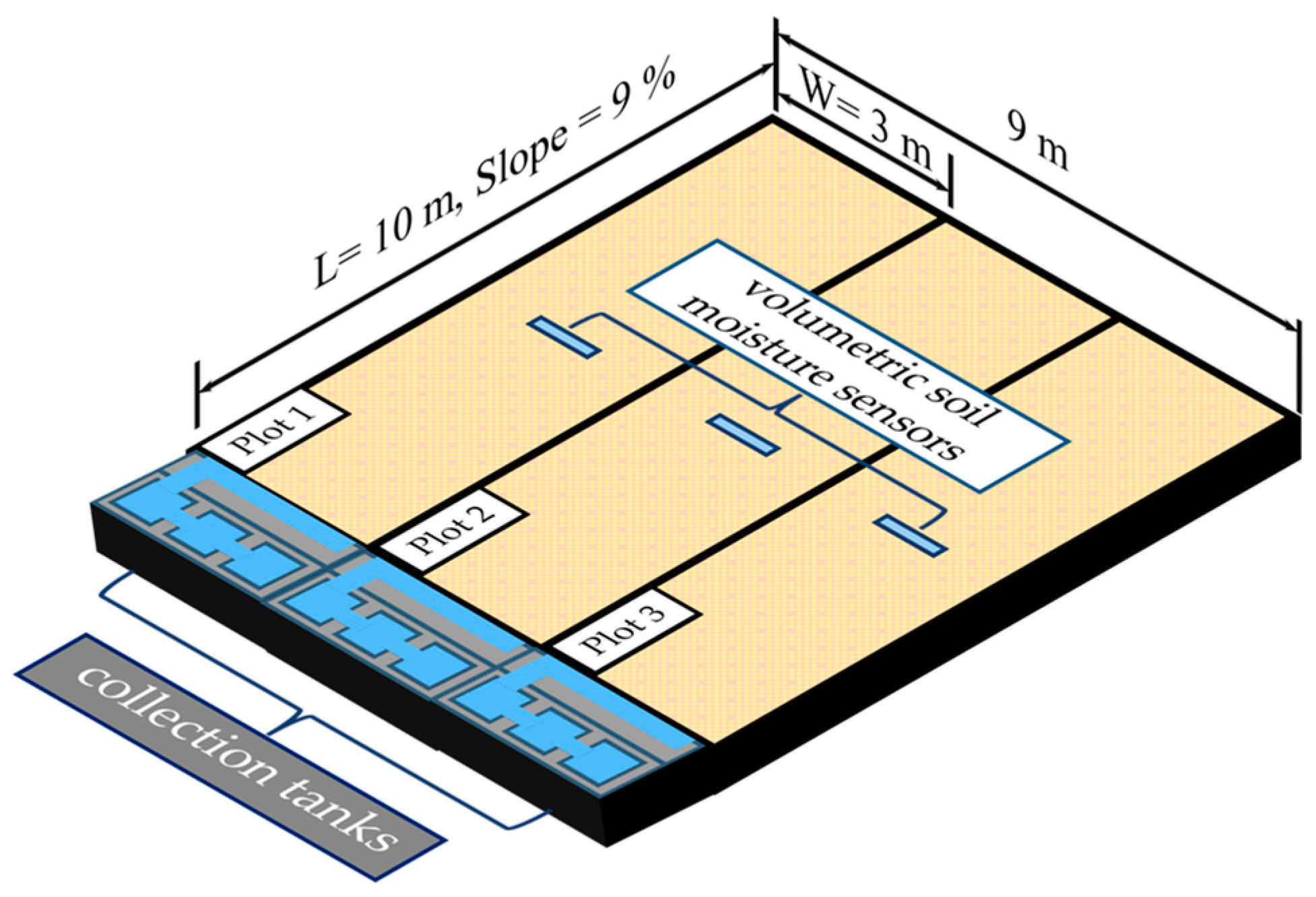
The experiment site is in a tropical climate zone at 22°38′41″ N and 120°36′23″ E (Soil Erosion Experiment Site at the National Pingtung University of Science and Technology). The average annual rainfall is about 2500~3000 mm. The rainy season usually begins in early May and lasts until late September. The soil at the experiment site was first plowed and disked to a depth of about 35 cm at least three times earlier in the year. Residue, including roots and ground vegetation, was manually removed. The soil was also mixed along the slope, as well as between the plots, to achieve soil consistency. Due to plowing and disking, a plow sole was formed at a depth of about 35~40 cm. Soil samples were taken randomly along the slope and within the plow layer prior to plot preparation for analyses of soil physical properties. The soil at the experiment site consists of 18.84% sand, 31.73% silt, and 49.71% clay, and it is classified as clay according to the United States Department of Agriculture (USDA) soil texture classification. The average organic matter content is 1.65%.
A total of three runoff plots were prepared, and all runoff plots remained bare throughout the rainy season. Based on past experiences, rills seldom occur under natural rainfall conditions when the slope length is shorter than 10 m; therefore, each runoff plot was set up with a length of 10 m and a width of 3 m, and the plot surface was leveled to the desired gradient of 9%. Cemented brick walls were installed along the periphery of the runoff plot to a depth of 1 m to prevent additional water sources from entering the plot, as well as lateral infiltration between adjacent plots.
The field study started in early 2019 and ended in late 2020, covering two consecutive rainy seasons. Due to plot availability, only one runoff plot was used in 2020; hence, the three runoff plots that were used in 2019 for this study were considered three replications. Disking was performed at the end of the rainy season to break any surface crust, and soil was randomly exchanged and mixed between plots prior to leveling for the incoming year’s experiment.
Before this study, we tested the installation of EC-5 volumetric soil moisture sensors (Onset, Bourne, MA, USA) at different depths (5 cm and 10 cm) and at various distances (2.5 m, 5 m, and 7.5 m) from the top of the runoff plot using the same field plot setup to understand how the locations of the soil moisture sensors affected the sensors’ readings. After two years of testing, we found that the soil moisture data from different locations along the slope were almost synchronous. Therefore, an EC-5 volumetric soil moisture sensor was installed 10 cm below the ground surface at the mid-length of each runoff plot to monitor soil moisture content. The volumetric soil moisture content was automatically logged (Onset, Bourne, MA, USA) every 5 min throughout the entire study period. A schematic drawing of the setup of the runoff plots, rain gauge, and locations of the soil moisture sensors and collection tanks is illustrated in Figure 1.
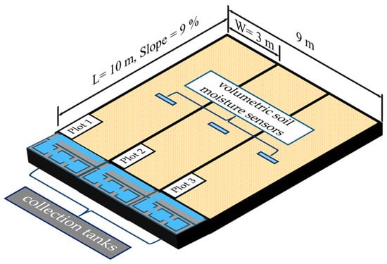
Figure 1.
Schematic drawing of field experiment setup.
2.2. Data Collection and Analysis
2.2.1. Rainfall
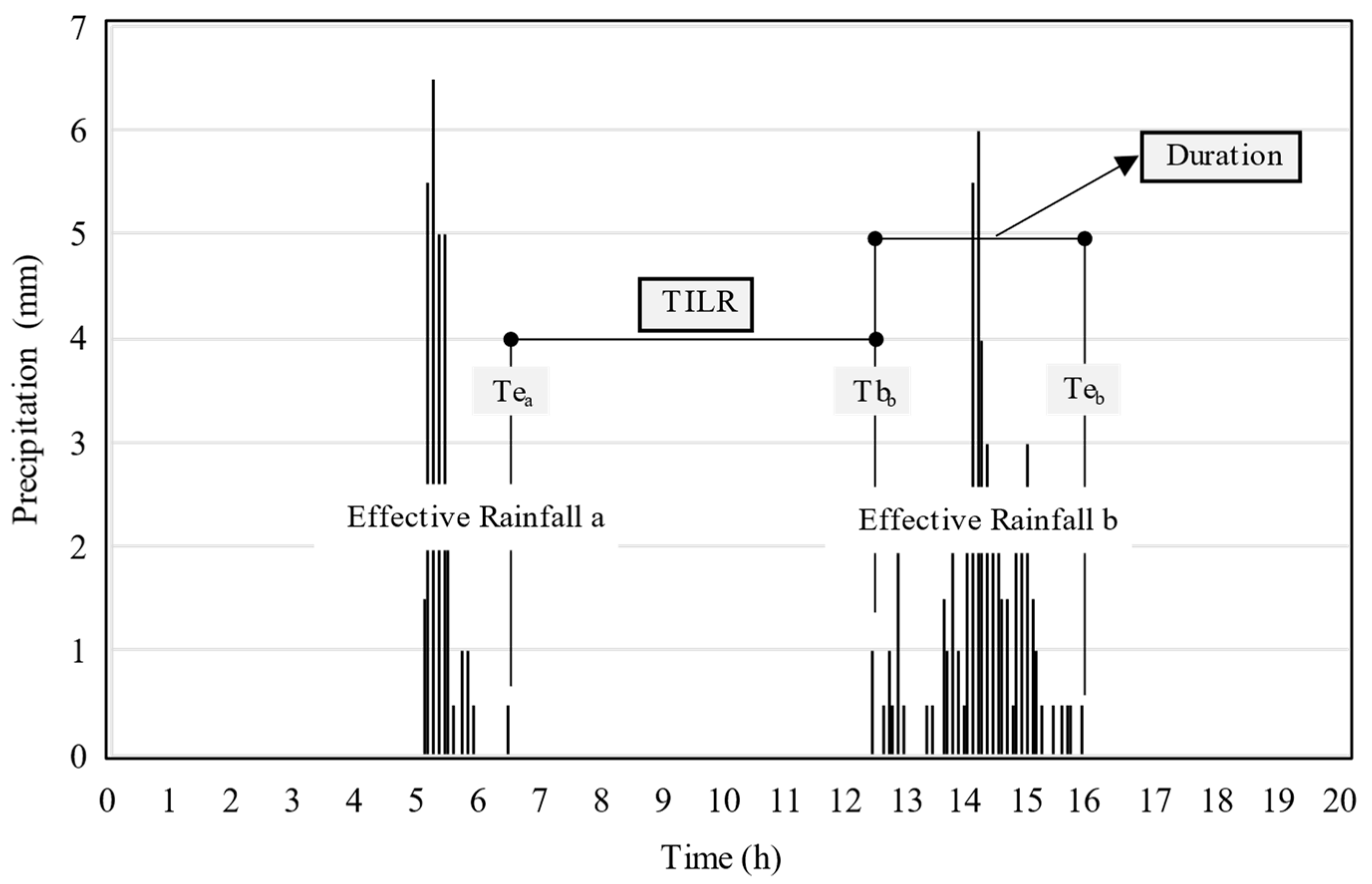
A 0.5 mm tipping-bucket rain gauge (Takeda Instruments Co., Ltd., Tokyo, Japan) attached to a data logger (HOBO Pendant Event Data Logger, Onset, Bourne, MA, USA) was used to log the rainfall records, and the records were used to extract the rainfall characteristics, including total precipitation (P, mm), maximum 30 min rain intensity (I30max, mm/h), event duration (duration, h), the time interval between two adjacent effective erosion events (TILR, h), and total precipitation within the past x hours prior to an effective erosion event (Ppx, mm).
Effective erosion events were delineated from the rainfall records based on the effective rainfall event definition given by Wischmeier and Smith (1978) [6]. An effective rainfall event is defined as when a rainfall event satisfies the following two criteria: (1) the accumulated rainfall of an event exceeds 12.7 mm or more than 6.35 mm rain falls within 15 min and (2) the time interval between the current event and preceding event exceeds 6 h.
Based on 7 yr field observations prior to 2019, we found that surface runoff often occurred at the experiment site when the accumulated rainfall exceeded 19.0 mm. The 19 mm threshold value can result either from long-duration events or short but heavy storms, and this threshold decreases when one storm occurs after another in two to three days. Therefore, the 19 mm rainfall threshold seems to be an appropriate indicator for field erosion studies at our site. Our past field observations generally support Wischmeier and Smith’s definition of an effective rainfall event. Therefore, we followed the same definition to extract the effective rainfall events (hereafter termed an effective erosion event) from our rainfall records for data analysis.
The end time (Tea) and begin time (Tbb) were used to extract the time interval between two adjacent effective erosion events (TILR) (Figure 2). The TILR reflects the opportunity for soil to be exposed to natural drying, a similar idea to the 6 h break between storms in Wischmeier and Smith’s effective rainfall event definition. The longer the TILR, the lower the antecedent soil moisture becomes. During the process of extracting the TILR, some rain events that did not meet the criteria of an effective rainfall event were excluded.
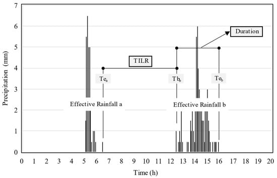
Figure 2.
Delineation of effective erosion events, TILR, and duration.
Different climate regions produce different rainfall characteristics. We often experience downpours resulting from convectional rain, frontal rain, and typhoons during summer, but continuous drizzle seldom occurs at the experiment site. Due to the rare occurrence of continuous drizzle, we found from the volumetric soil moisture sensor data that the impact of light drizzle on surface soil moisture content was minimal, and the surface soil moisture quickly returned to the stage prior to the rain. Furthermore, from the onsite rainfall records, it was found that a total of 20 mm of discrete light drizzle occurred in 2019 and in 2020, only accounting for 0.89% of the 2239.5 mm of the total rainfall and 0.99% of the 2016 mm of the total rainfall, respectively. Therefore, we chose to exclude these ineffective events by assuming that these events had no impact on antecedent soil moisture content. The two-year field soil moisture logging and rainfall records justified our assumption.
“Duration” is the length of time (in hours) that an effective erosion event lasts, and it is the time span between Tbb and Tbe (Figure 2). Natural rainfall records may include rain-free intervals, and these intervals vary in length. Therefore, effective erosion events with a longer duration may include a higher portion of rain-free periods; conversely, events with a shorter duration typically have less chance or a lower portion of rain-free periods.
“Ppx” is defined as the accumulated rainfall (in mm) within x hours prior to the beginning of an effective erosion event. The estimation of Ppx involves tracing backward in time from Tb by a specific “x hours” time range and summing up the rainfall amounts within, as illustrated in Figure 3. Five different time ranges, namely 12, 24, 48, 72, and 120 h, were used in this study. Ppx reflects the amount of rain that soil receives before the occurrence of an effective erosion event. If the number of “x hours” selected is too low, influential antecedent rainfall may be overlooked. Conversely, if it is too high, it may include non-influential antecedent rainfall.
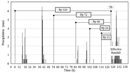
Figure 3.
Determination of Ppx with different x–h time ranges.
Lastly, the Rainfall–Runoff Erosivity Index (EI30) was calculated based on the USLE definition proposed by Wischmeier and Smith (1978) [6]. This index is the product of the total kinetic energy and maximum 30 min rainfall intensity (I30max) of an effective erosion event. Wu and Wang (1996) [33] conducted a 3 yr field study on raindrop distributions and rainfall kinetic energy at the experiment site, and they found that their rainfall kinetic energy formula deviated from Wischmeier and Smith’s formula when the rainfall intensity was less than 4.0 mm/h. For the sake of simplicity in the calculation, Wischmeier and Smooth’s rainfall kinetic energy formula was used in this study to calculate the total kinetic energy of an effective erosion event. The I30max of an effective erosion event was extracted from the rainfall records.
2.2.2. Runoff and Soil Loss
A collection tank was installed downstream of the runoff plot to collect surface runoff and soil loss. To accommodate a large runoff volume exceeding the tank design volume, two partition walls were arranged inside the collection tank, which resulted in a tank with three separate pools. A blade consisting of five 60° sharp-crested triangular weirs and a blade with single sharp-crested triangular weirs were installed at the rim of each partition wall. These two weir blades were carefully installed so that the notches were at the same elevation to ensure the evenness of runoff splitting. The excess runoff overflowing from the five-weir blade was discarded, and that from the single-weir blade overflew to the next pool. The second pool was also equipped with the same weir blades. Therefore, the second pool collected 1/6 of the runoff overflown from the first pool, and the third pool collected 1/6 of the runoff overflown from the second pool, which was 1/36 of the overflown runoff from the first pool. Hence, when runoff accumulated in both the second and third pools, the runoff volume in the second pool was multiplied by 6, and the runoff volume in the third pool was multiplied by 36; then, they were added to the runoff volume collected in the first pool, finally yielding the total runoff volume of the event. When runoff only accumulated in the first and second pools, the runoff volume in the second pool was multiplied by 6 and then added to the runoff volume in the first pool to yield the total runoff volume. Figure 4 illustrates a three-pool collection tank.
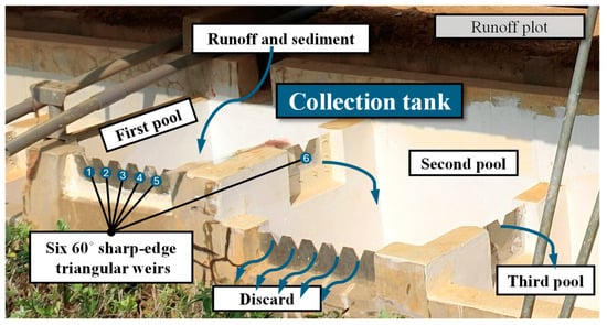
Figure 4.
The collection tank.
Soil loss was calculated from grab samples of detained sediment in the first pool and added to grab samples of suspended sediment collected from each pool. Grab samples of suspended load were also taken from each pool. They were oven-dried, back-calculated using the grab sample and detained sediment volume ratios, and then added together to obtain the total soil loss. Runoff and soil loss collection was carried out on a storm-by-storm basis.
2.2.3. Antecedent Soil Moisture Content
To eliminate the effect of soil texture differences between runoff plots, the volumetric soil moisture data were first normalized as follows:
where NVSMCi is the normalized volumetric soil moisture content at time Ti, VSMCi is the volumetric soil moisture content at time Ti, and VSMCmin and VSMCmax are the minimum and maximum volumetric soil moisture contents detected during the rainy season, respectively.
Ti is the key point for analyzing the normalized antecedent volumetric soil moisture content (NAVSMC), and it must accurately represent the time right before the start of a rain event. It is slightly earlier than the beginning of a rain event (Tb). In this study, Ti is set approximately 5 to 10 min prior to the Tb based on the soil moisture contents logged throughout the study period.
3. Results and Discussion
Table 1 summarizes the 2-year field experiment data, as well as the results extracted from the rainfall, runoff, and soil loss data. Events 1~37 in Table 1 were replications; therefore, they shared the same rainfall parameters. The abbreviations in Table 1 are defined as follows: Precp. is the total precipitation of an effective erosion event, EI30 is the Rainfall–Runoff Erosivity Index, C is the runoff coefficient, NAVSMC is the normalized antecedent volumetric soil moisture content, Ppi is the accumulated rainfall within i hours (i = 1, 24, 48, 72, and 120) prior to the beginning of an effective erosion event, and TILR is the time interval between two adjacent effective erosion events. Unit area soil loss (kg/m2) and unit area runoff volume (mm3/mm2) are the total soil loss and total runoff volume collected from an effective erosion event divided by the runoff plot area, respectively.

Table 1.
Summary of field experiment results.
No rills were found in the 10 m long runoff plots during the field experiment periods. Within the scope of this study, surface runoff was mainly responsible for transporting the eroded soil that was generated by splash and sheet erosion, also known as interrill erosion. A positive correlation that fits a power function of Y = 0.0248X0.8055 exists between the unit area runoff volume (X; mm3/mm2) and unit area soil loss (Y; kg/m2), with a coefficient of determination of R2 = 0.82, despite greater variabilities in natural rain settings.
A Pearson correlation analysis (Microsoft EXCEL 2021) was also conducted between the unit area soil loss; unit area runoff volume; and selected rainfall parameters, namely, NAVSMC (the normalized antecedent volumetric soil moisture content), duration, Ppx (the accumulated rainfall within x hours prior to the beginning of an erosion event), and TILR (time interval between two adjacent events). A correlation with a coefficient greater than 0.75 is classified as a strong correlation, a coefficient between 0.5 and 0.75 is classified as a moderate correlation, and a coefficient between 0.25 and 0.5 is interpreted as a weak correlation. The results of the Pearson correlation coefficients are summarized in Table 2, in which the data cells shaded with a gray background have p values greater than 0.05, and the other cells without a gray background have p values less than 0.05. The results in Table 2 indicate that the unit area soil loss is strongly positively correlated with the unit area runoff volume, precipitation, duration, and Pp48. It is moderately positively correlated with Pp24 and Pp72, and it is weakly positively correlated with Pp12 and Pp120. However, it is negatively correlated with TILR. A weak and negative correlation was found between the unit area soil loss and NAVSMC.
Table 2.
Summary of Pearson correlation coefficients of field experiment results.
The time range x chosen to calculate the accumulated rainfall (Ppx) prior to an erosion event affects the Pearson correlation coefficients. The effective erosion events collected in this study seldom had any rain within the 12 h time range before their occurrence. Hence, most of the erosion events have zero rainfall in the Pp12 column shown in Table 1. However, Pp120 includes rainfall events that may not be effective enough to initiate erosion, resulting in a higher amount of rainfall but not the equivalent soil loss. If a 72 h time range were chosen, the number of ineffective rainfall events included would be less, so the correlation would change from weakly positive to moderately positive, whereas Pp24 excluded the soil weakening or soil recovery effects of storms occurring 24 to 36 h prior to the current effective storm on the soil, which depended on the nature of the storm and how far apart two adjacent storms were. We found that Pp48 is the best parameter capable of including the antecedent storms at the experiment site and achieves the best performance in the correlation analysis.
The effect of the time interval between two adjacent events (TILR) on the antecedent soil moisture content is somewhat similar to that of the accumulated rainfall prior to an erosion event (Ppx). The shorter the TILR, the lower the chance that the soil dries naturally. In general, any ineffective rainfall such as drizzle prior to an effective erosion event may alter the soil wetness. However, the negative weak correlation between the TILR and unit area soil loss (Table 2) indicates that all storm events collected in this study fail to support TILR’s contribution to soil erosion.
Duration is another rainfall characteristic considered in this study, and the correlation analysis shows that it is strongly positively correlated with unit area soil loss (Table 2) as expected. However, the duration of a rainfall event masks the contribution of the antecedent soil moisture content.
The amount of soil loss is also affected by the Rainfall–Runoff Erosivity Index (EI30), which is a known fact, and EI30 is the foundation for describing the rainfall and runoff erosivity for most soil loss estimation models. It is relatively easy to run replicate experiments and obtain similar results using a rainfall simulator in a laboratory setting, in which the rainfall intensity, soil moisture content, and duration of recess between experiments can be controlled. However, the variables controlling rainfall characteristics and soil properties are constantly changing in field experiments under natural rainfall. Therefore, we divide the unit area soil loss by the storm’s Rainfall–Runoff Erosivity Index (EI30), which is denoted as Soil Loss/EI30 hereafter. Soil Loss/EI30 is the unit area soil loss per Rainfall–Runoff Erosivity. It quantifies how erodible soil becomes, which is also known as soil erodibility.
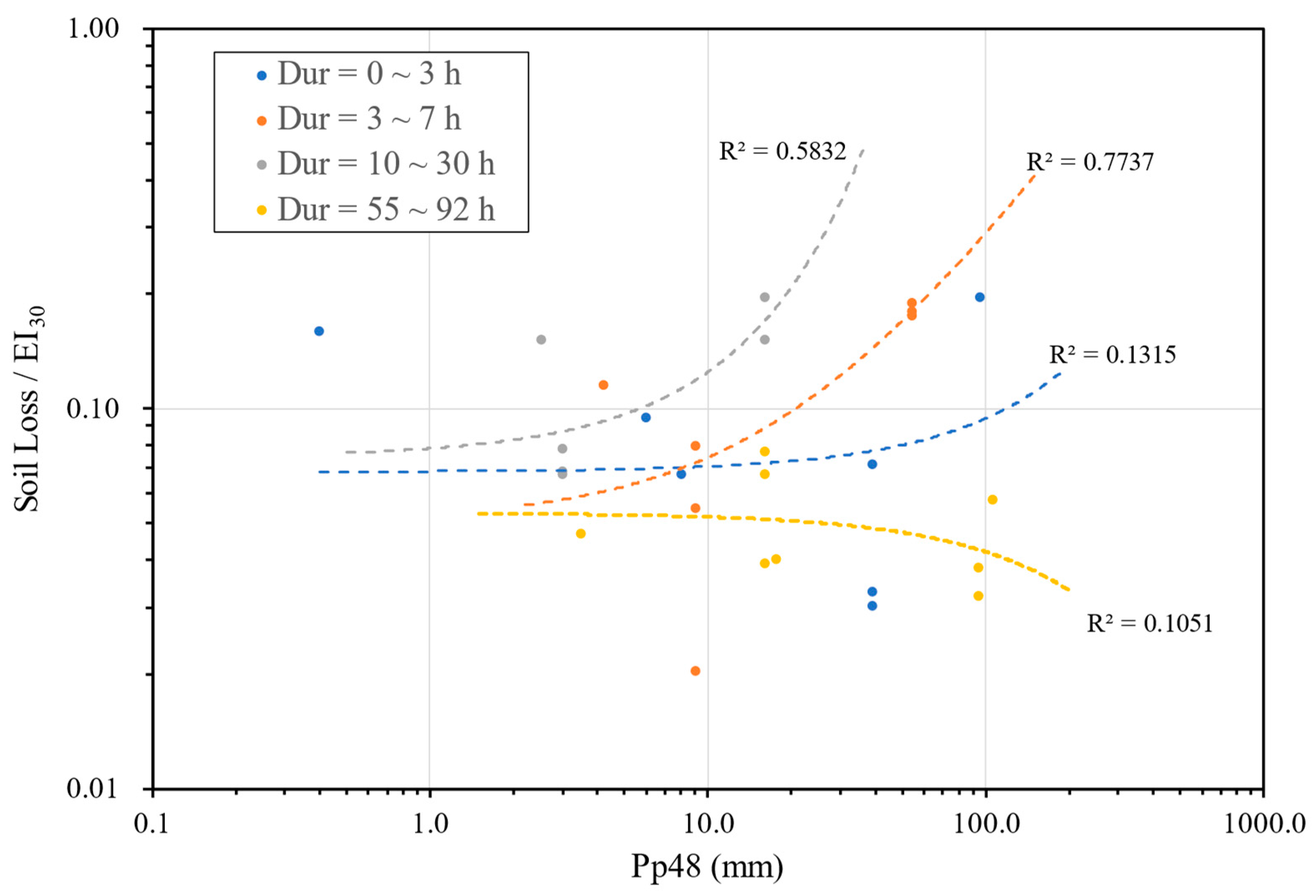
We plot Soil Loss/EI30 with respect to Pp48 but exclude data where Pp48 equals zero, i.e., where no rainfall occurred 48 h before the erosion event. The resultant plot that grouped four durations (Dur) is shown in Figure 5. The rationale for grouping data by rainfall event duration is that event duration affects the total soil loss, as well as EI30. The effect of event durations cannot be determined in laboratory rainfall simulation studies with constant rainfall intensities and durations.
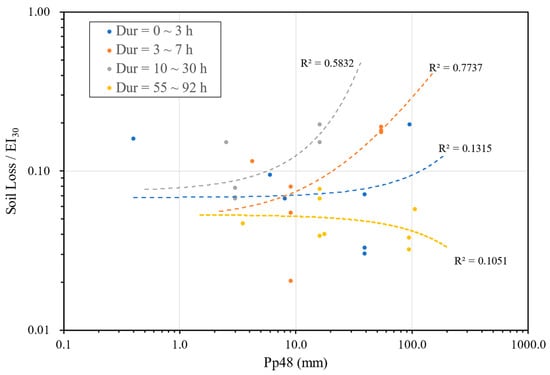
Figure 5.
Trends in unit area soil loss per EI30 with respect to Pp48, grouped by rainfall durations.
Grouping data by event duration makes the data appear scattered. Fitting trends to each data group helps visualize the general trend that a field experiment under natural rainfall conditions tends to present. The trends shown in Figure 5 indicate that the total rainfall that occurs 48 h (Pp48) prior to an effective erosion event has the lowest coefficient of determination (R2 = 0.1051) when the duration of an effective erosion event exceeds 55 h. When the duration of an effective erosion event is either 3~7 h or 10~30 h, R2 becomes 0.7737 or 0.5832, respectively. Both trends follow a similar pattern.
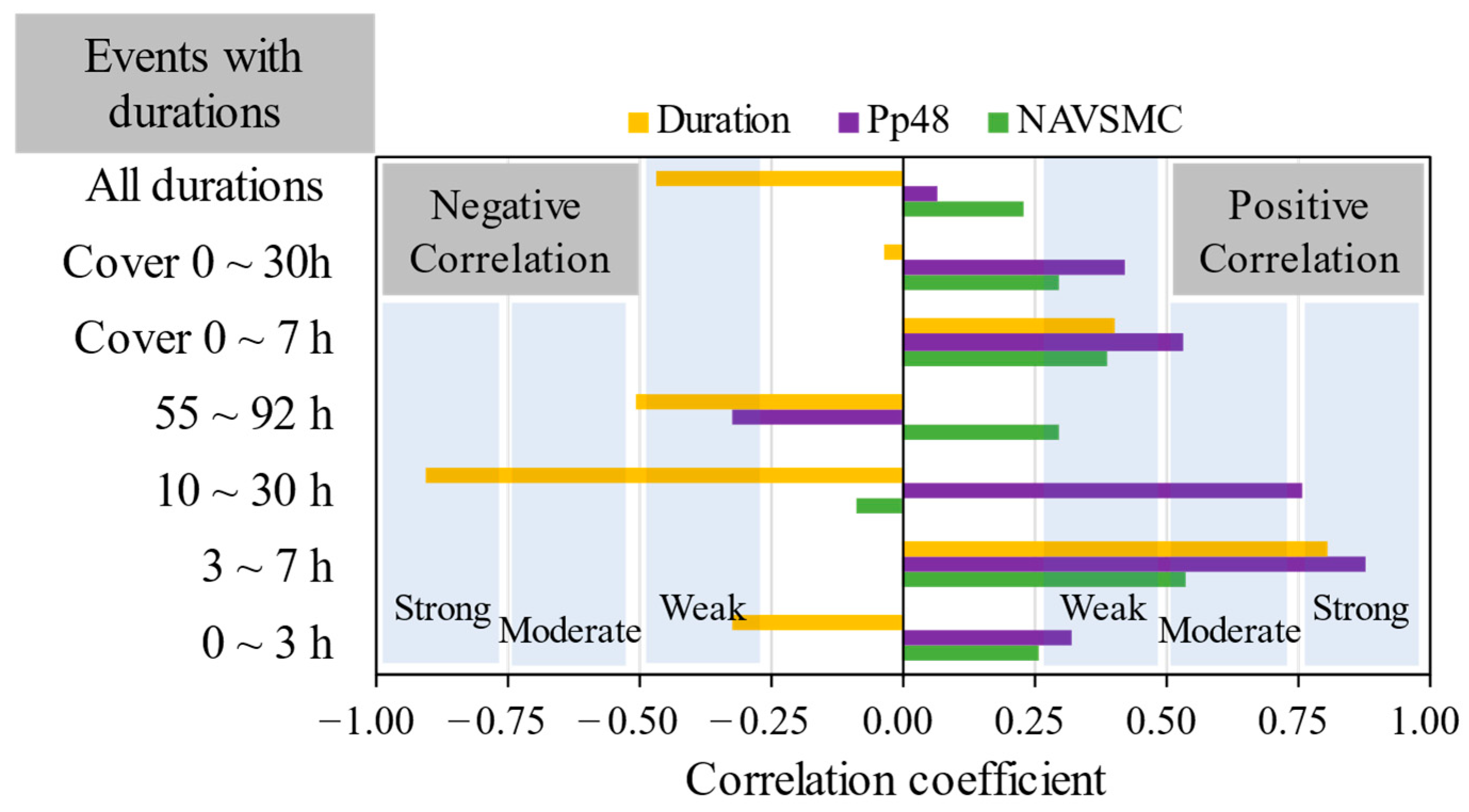
We further conduct a Pearson correlation analysis on Soil Loss/EI30 with respect to the normalized antecedent volumetric soil moisture content (NAVSMC), Pp48, and rainfall duration by first excluding cases where Pp48 equal zero, and the results are shown in Table 3 and Figure 6. Through a two-tailed test, it was found that all the correlation coefficients listed in Table 3 have a p-value of less than 0.05.
Table 3.
Pearson correlation coefficients with respect to Soil Loss/EI30.
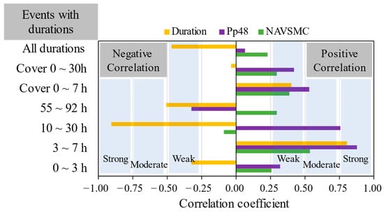
Figure 6.
Pearson correlation coefficients with respect to Soil Loss/EI30.
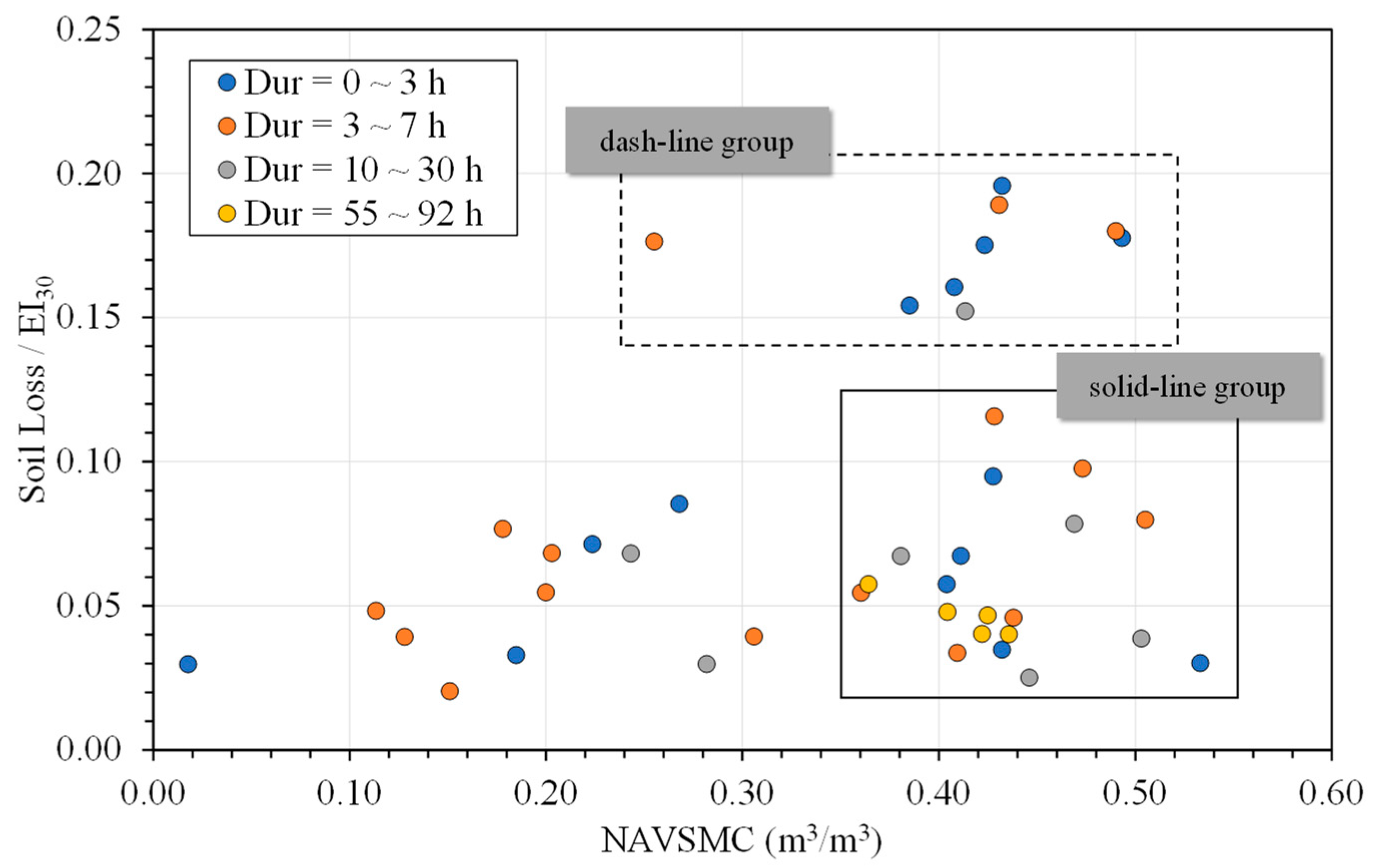
From Table 3 and Figure 6, we find that the normalized antecedent volumetric soil moisture content (NAVSMC) is moderately correlated with Soil Loss/EI30 when the duration of an effective erosion event is within 3 to 7 h, whereas Pp48 and rainfall duration are strongly correlated with Soil Loss/EI30. In order to identify the conditions under which the antecedent volumetric soil moisture content affects Soil Loss/EI30, we only selected data with Pp12 ≠ 0 to eliminate the effect of the accumulated rainfall prior to the erosion event and generated a scatter plot on Soil Loss/EI30 against the NAVSMC; the result is shown in Figure 7.
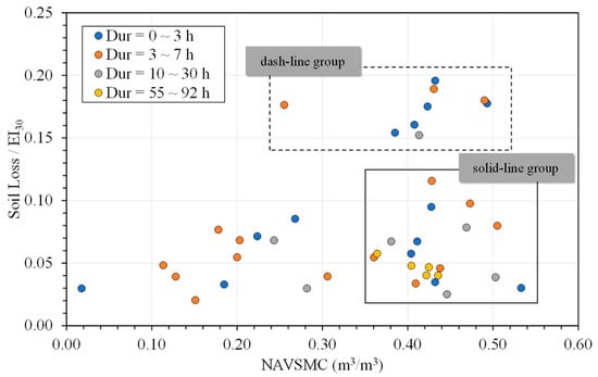
Figure 7.
Soil Loss/EI30 vs. normalized antecedent volumetric soil moisture content (NAVSMC).
Regardless of the dispersion of the data in Figure 7, we found that the data points were segregated into three distinct clusters: a solid-line cluster, a dashed-line cluster, and an ungrouped cluster. We chose to delineate our data because each cluster possessed different characteristics in the identification process used to identify the common characteristics of the data points.
The ungrouped cluster had two characteristics: (1) NAVSMC < 0.35 and (2) Soil Loss/EI30 < 0.1. The remaining data were further delineated into solid- and dashed-line groups because both groups had an NAVSMC of > 0.30 but considerably different results in terms of Soil Loss/EI30. In addition, the solid- and dashed-line groups demonstrated different soil erodibility under a high antecedent soil moisture content, while the ungrouped data points demonstrated a generally low soil erodibility under a low antecedent soil moisture content. Through further analysis, we found that the rainfall conditions between the solid- and dashed-line groups were noticeably different, and these rainfall conditions suggested that we had to exclude the ungrouped data from the solid-line group.
The data points in the dashed-line group in Figure 7 are Events # 26, 27, 28, 30, 31, 41, 43, 45, and 50, and the data points in the solid-line group are Events # 3, 6, 9, 18, 19, 21, 22, 24, 25, 34, 36, 37, 38, 39, 40, 42, 46, 47, 48, and 49 (Table 1). We found that the dashed-line group shared the common characteristics of a short duration, a short TILR, a low rainfall amount, a low average rain intensity, and a low EI30 value. The solid-line group exhibited opposite characteristics to the dashed-line group.
We further found that rainfall events with an NAVSMC greater than 0.36 in Figure 7 (data of the solid-line group) were associated with the common characteristics of stronger storms. The average rainfall duration was 22.0 h, approximately 3.5 time longer than that of the dashed-line group (6.23 h). The average rainfall amount was 103.1 mm, almost five times higher than that of the dashed-line group (19.75 mm), and the average EI30 was 1570.14 MJ-mm/ha-h, 20 times higher than that of the dashed-line group (78.7 MJ-mm/ha-h).
Furthermore, the average NAVSMC of these events was 0.41, slightly higher than the overall average of 0.35, while the average time interval between two adjacent events (TILR) was about 40.5 h, roughly one-third of the overall average of 104.33 h, and the average rain intensity was about 8.3 mm/h. According to the rain intensity classification of the World Meteorological Organization (2018) [34], these events fell in the lower boundary of the heavy rain category, with an average intensity between 7.6 and 50 mm/h.
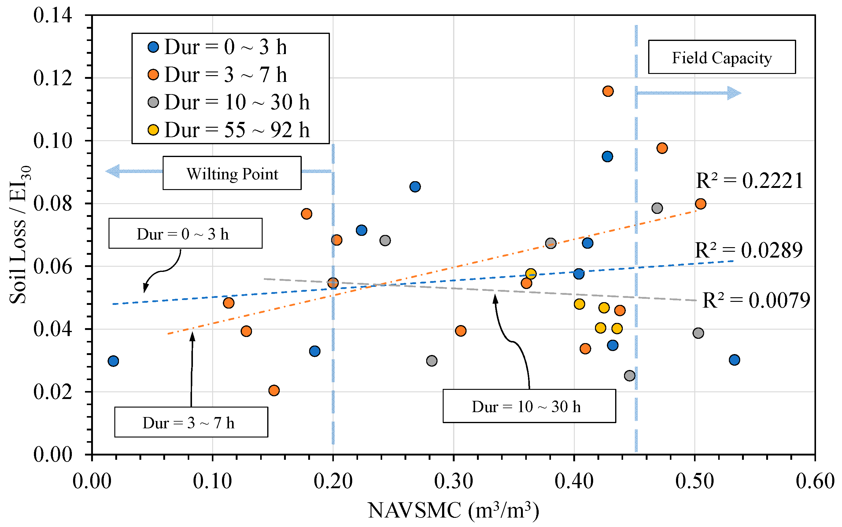
Two scatter plots were subsequently drawn, as shown in Figure 8 and Figure 9. Rainfall events with Soil Loss/EI30 greater than 0.15, i.e., the dashed-line group in Figure 7, were excluded from the plot in Figure 8, whereas the solid-line group in Figure 7 was excluded from the plot in Figure 9. The rationale for constructing these two figures was that the data of the solid-line group were associated with stronger storms, as previously stated, and the data of the dashed-line group were not.
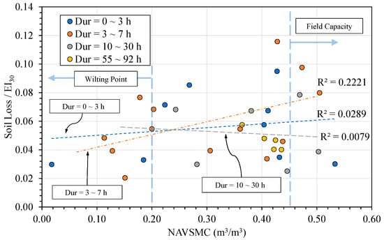
Figure 8.
Soil Loss/EI30 vs. NAVSMC (excluding dashed-line group in Figure 7).

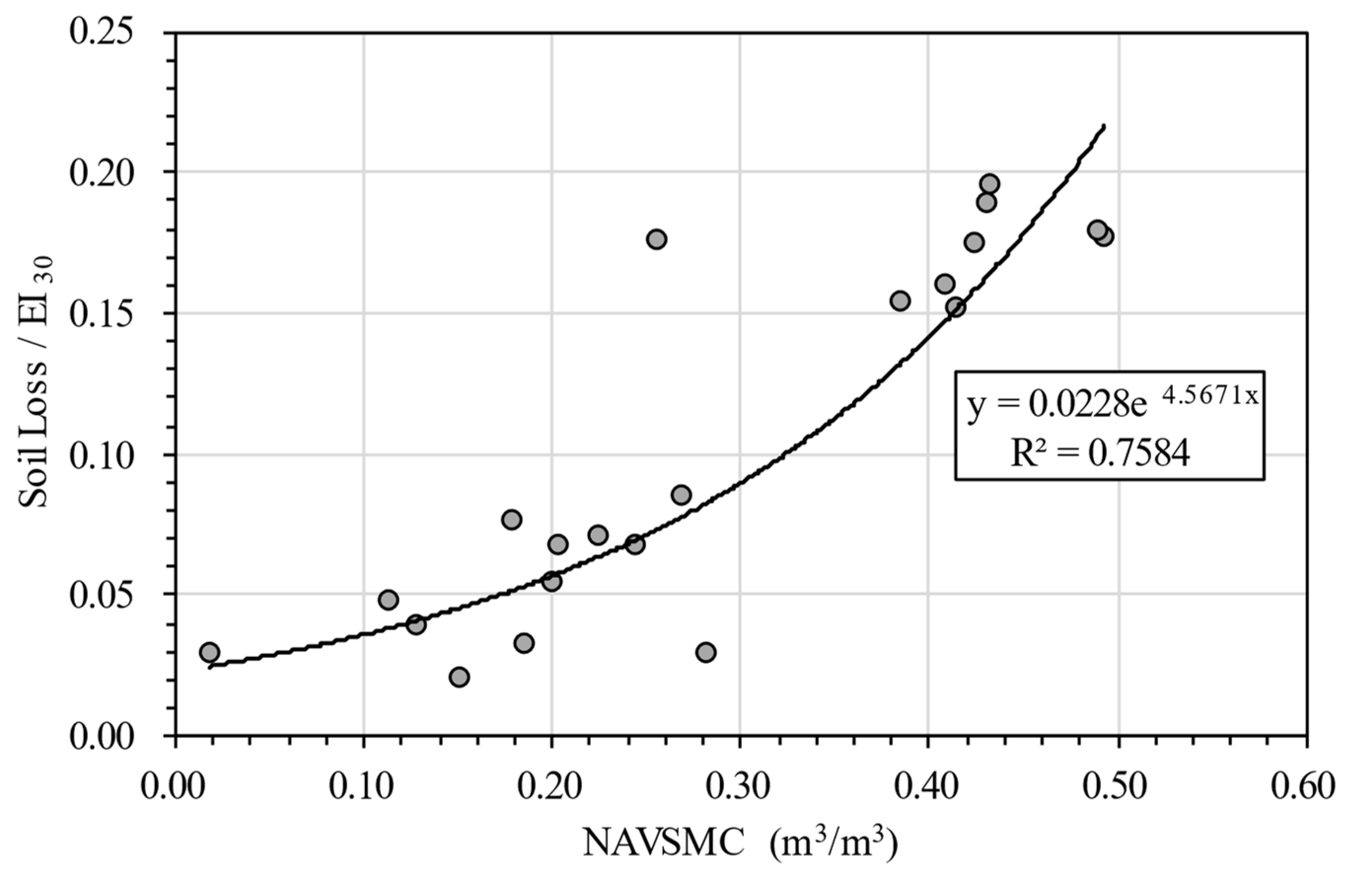
Figure 9.
Soil Loss/EI30 vs. NAVSMC (excluding solid-line group in Figure 7).
The reasons for fitting the linear regression lines through the three duration groups in Figure 8 are as follows: (1) it is easy to see the general trends, even if the coefficients of determination are low, and (2) it is difficult to isolate the nonlinear effects of NAVSMC, if any, on soil vulnerability to erosion or soil erodibility, as this study was conducted under natural rain conditions. From Figure 8, we found that 66.7% of the events occurred with NAVSMCs within the wilting point and field capacity. The dispersion of the soil erodibility data expanded and covered a wider range when the NAVSMC exceeded 0.36, which is clearly illustrated in both Figure 7 and Figure 8.
The best-fit curve shown in Figure 9, which excludes the solid-line group associated with stronger storms in Figure 7, exhibits a high coefficient of determination with an R2 = 0.7584, from which we conclude that (1) the impact of antecedent soil moisture content on soil erosion is conditional and (2) the impact of antecedent soil moisture content on soil erosion must be considered for rainfall events with a short duration, short TILR, lower average rain intensity, and low EI30.
To verify our conclusion, a Pearson correlation analysis was again conducted. The correlation coefficients on Soil Loss/EI30 with respect to the NAVSMC and other parameters associated with the antecedent rainfall amount (Ppx), event duration, and time interval between two adjacent events (TILR) are summarized in Table 4. In Table 4, the data cells shaded with a gray background have a p-value greater than 0.05, and all data cells without a gray background have a p-value of less than 0.05.
Table 4.
Pearson correlation coefficients of Soil Loss/EI30 with respect to NAVSMC and other rainfall parameters.
The results in Table 4 indicate that the best correlation between Soil Loss/EI30 and NAVSMC falls in the 0~4 h rainfall duration range. In contrast, events with a duration exceeding 10 h exhibit relatively lower correlations for most of the considered parameters. Therefore, we suggest that the impact of antecedent soil moisture content on soil erosion can be ignored for events with a duration exceeding 10 h.
4. Conclusions
This study was conducted under natural rainfall for two consecutive seasons at the plot scale to investigate the impact of the antecedent soil moisture content on the interrill erosion of clay soil. This study provides evidence that addresses the contradictory or inconclusive conclusions in previous studies on the antecedent soil moisture issue. The key points of the findings are summarized as follows:
- Antecedent soil moisture content has an effect on unit area soil loss per EI30 (Soil Loss/EI30) in rainfall events with short durations, low rainfall amounts, and low Rainfall–Runoff Erosivity. When the average rainfall intensity is between 7.6 and 50 mm/h, which is classified into the heavy rain category by the World Meteorological Organization (2018), the impact of antecedent volumetric soil moisture content is negligible.
- There is a positive correlation between antecedent soil moisture content and unit area soil loss per EI30 (Soil Loss/EI30) for rainfall events with a 0~4 h duration. When the event duration exceeds 10 h, the impact of antecedent soil moisture on soil erosion can be ignored.
- The results of this field study on clay soil suggest that accumulative rain falling within 48 h (Pp48) prior to an effective erosion event is strongly correlated with unit area soil loss per Rainfall–Runoff Erosivity (Soil Loss/EI30). When the duration of an effective erosion event is less than 10 h, Pp48 makes a noticeable contribution to soil loss. However, when Pp48 is less than 20 mm, it does not affect soil loss in events with a 0~3 h duration.
Additional effort is required to continuously log the changes in antecedent soil moisture content. However, Pp48 can be extracted from rainfall records without much difficulty. In addition, to obtain representative values, soil moisture logging often requires additional post-processes that may overwhelm process-based soil loss simulation users. Hence, replacing the antecedent soil moisture content parameter with Pp48 seems to be a suitable alternative approach. Future studies are still needed, particularly on less clayey soils, to fully grasp the impact of antecedent soil moisture content on soil erosion.
Author Contributions
Conceptualization, Y.-D.C. and C.-C.W.; methodology, C.-C.W.; validation, Y.-D.C. and C.-C.W.; formal analysis, Y.-D.C. and C.-C.W.; investigation, Y.-D.C.; resources, C.-C.W.; data curation, Y.-D.C. and C.-C.W.; writing—original draft preparation, Y.-D.C.; writing—review and editing, C.-C.W.; visualization, Y.-D.C. and C.-C.W.; supervision, C.-C.W. All authors have read and agreed to the published version of the manuscript.
Funding
This study was self-funded without any external financial support.
Data Availability Statement
The original contributions presented in the study are included in the article, and further inquiries can be directed to the corresponding authors.
Acknowledgments
The authors wish to express their gratitude to those who helped prepare the field plots and assisted in collecting data.
Conflicts of Interest
The authors declare no conflicts of interest.
References
- Bennett, H.H. Soil Conservation, 1st ed.; McGraw-Hill Book Company: New York, NY, USA, 1939. [Google Scholar]
- Kirkby, M.J.; Morgan, R.P.C. (Eds.) Soil Erosion; Wiley: Chichester, UK; New York, NY, USA, 1980; ISBN 978-0-471-27802-3. [Google Scholar]
- Wang, Y.; Liu, G.; Zhao, Z.; Wu, C.; Yu, B. Using Soil Erosion to Locate Nonpoint Source Pollution Risks in Coastal Zones: A Case Study in the Yellow River Delta, China. Environ. Pollut. 2021, 283, 117117. [Google Scholar] [CrossRef] [PubMed]
- Borah, D.K.; Bera, M. Watershed-Scale Hydrologic and Nonpoint-Source Pollution Models: Review of Mathematical Bases. Trans. Am. Soc. Agric. Eng. 2003, 46, 1553–1566. [Google Scholar] [CrossRef]
- An, J.; Zheng, F.L.; Han, Y. Effects of Rainstorm Patterns on Runoff and Sediment Yield Processes. Soil Sci. 2014, 179, 293–303. [Google Scholar] [CrossRef]
- Wischmeier, W.H.; Smith, D.D. Predicting Rainfall Erosion Losses: A Guide to Conservation Planning; Department of Agriculture, Science and Education Administration: Washington, DC, USA, 1978.
- Alewell, C.; Borrelli, P.; Meusburger, K.; Panagos, P. Using the USLE: Chances, Challenges and Limitations of Soil Erosion Modelling. Int. Soil Water Conserv. Res. 2019, 7, 203–225. [Google Scholar] [CrossRef]
- Renard, K.G.; Foster, G.R.; Weesies, G.A.; McCool, D.K.; Yoder, D.C. (Eds.) Predicting Soil Erosion by Water: A Guide to Conservation Planning with the Revised Universal Soil Loss Equation (RUSLE); Agricultural Handbook; USDA, Agricultural Research Service: Washington, DC, USA, 1997; ISBN 978-0-16-048938-9.
- Knisel, W.G. CREAMS: A Field Scale Model for Chemicals, Runoff, and Erosion from Agricultural Management Systems; Conservation Research Report; Department of Agriculture, Science and Education Administration: Washington, DC, USA, 1980.
- Young, R.; Onstad, C.; Bosch, D.; Anderson, W. AGNPS: A Non-Point-Source Pollution Model for Evaluating Agricultural Watersheds. J. Soil Water Conserv. 1989, 44, 168–173. [Google Scholar]
- Laflen, J.M.; Elliot, W.J.; Flanagan, D.C.; Meyer, C.R.; Nearing, M.A. WEPP-Predicting Water Erosion Using a Process-Based Model. J. Soil Water Conserv. 1997, 52, 96–102. [Google Scholar]
- Flanagan, D.; Gilley, J.; Franti, T. Water Erosion Prediction Project (WEPP): Development History, Model Capabilities, and Future Enhancements. Trans. ASABE 2007, 50, 1603–1612. [Google Scholar] [CrossRef]
- Arnold, J.G.; Fohrer, N. SWAT2000: Current Capabilities and Research Opportunities in Applied Watershed Modelling. Hydrol. Process. 2005, 19, 563–572. [Google Scholar] [CrossRef]
- Wischmeier, W.H.; Johnson, C.B.; Cross, B. Soil Erodibility Nomograph for Farmland and Construction Sites. J. Soil Water Conserv. 1971, 26, 5189. [Google Scholar]
- Knapen, A.; Poesen, J.; Govers, G.; Gyssels, G.; Nachtergaele, J. Resistance of Soils to Concentrated Flow Erosion: A Review. Earth Sci. Rev. 2007, 80, 75–109. [Google Scholar] [CrossRef]
- Kemper, W.D.; Rosenau, R.C. Soil Cohesion as Affected by Time and Water Content. Soil Sci. Soc. Am. J. 1984, 48, 1001–1006. [Google Scholar] [CrossRef]
- Shainberg, I.; Goldstein, D.; Levy, G.J. Rill Erosion Dependence on Soil Water Content, Aging, and Temperature. Soil Sci. Soc. Am. J. 1996, 60, 916–922. [Google Scholar] [CrossRef]
- Le Bissonnais, Y.; Bruand, A.; Jamagne, M. Laboratory Experimental Study of Soil Crusting: Relation between Aggregate Breakdown Mechanisms and Crust Structure. Catena 1989, 16, 377–392. [Google Scholar] [CrossRef]
- Holz, D.J.; Williard, K.W.J.; Edwards, P.J.; Schoonover, J.E. Soil Erosion in Humid Regions: A Review. J. Contemp. Water Res. Educ. 2015, 154, 48–59. [Google Scholar] [CrossRef]
- Wei, L.; Zhang, B.; Wang, M. Effects of Antecedent Soil Moisture on Runoff and Soil Erosion in Alley Cropping Systems. Agric. Water Manag. 2007, 94, 54–62. [Google Scholar] [CrossRef]
- Auerswald, K.; Mutchler, C.K.; McGregor, K.C. The Influence of Tillage-Induced Differences in Surface Moisture Content on Soil Erosion. Soil Tillage Res. 1994, 32, 41–50. [Google Scholar] [CrossRef]
- Fortesa, J.; Latron, J.; García-Comendador, J.; Company, J.; Estrany, J. Runoff and Soil Moisture as Driving Factors in Suspended Sediment Transport of a Small Mid-Mountain Mediterranean Catchment. Geomorphology 2020, 368, 107349. [Google Scholar] [CrossRef]
- Massari, C.; Pellet, V.; Tramblay, Y.; Crow, W.T.; Gründemann, G.J.; Hascoetf, T.; Penna, D.; Modanesi, S.; Brocca, L.; Camici, S.; et al. On the Relation between Antecedent Basin Conditions and Runoff Coefficient for European Floods. J. Hydrol. 2023, 625, 130012. [Google Scholar] [CrossRef]
- Jadidoleslam, N.; Hornbuckle, B.; Krajewski, W.; Mantilla, R.; Cosh, M. Analyzing Effects of Crops on SMAP Satellite-Based Soil Moisture Using a Rainfall-Runoff Model in the U.S. Corn Belt. IEEE J. Sel. Top. Appl. Earth Obs. Remote Sens. 2021, 15, 247–260. [Google Scholar] [CrossRef]
- Schoener, G.; Stone, M.C.; Thomas, C. Comparison of Seven Simple Loss Models for Runoff Prediction at the Plot, Hillslope and Catchment Scale in the Semiarid Southwestern U.S. J. Hydrol. 2021, 598, 126490. [Google Scholar] [CrossRef]
- Luk, S.-H.; Hamilton, H. Experimental Effects of Antecedent Moisture and Soil Strength on Rainwash Erosion of Two Luvisols, Ontario. Geoderma 1986, 37, 29–43. [Google Scholar] [CrossRef]
- Wang, L.; Zheng, F.; Hu, W.; Zhang, X.J.; Shi, H. Interactive Effects of Rainfall Intensity, Kinetic Energy and Antecedent Soil Moisture Regime on Splash Erosion in the Ultisol Region of South China. Catena 2023, 222, 106863. [Google Scholar] [CrossRef]
- Castillo, V.; Gomezplaza, A.; Martinezmena, M. The Role of Antecedent Soil Water Content in the Runoff Response of Semiarid Catchments: A Simulation Approach. J. Hydrol. 2003, 284, 114–130. [Google Scholar] [CrossRef]
- Truman, C.C.; Bradford, J.M.; Ferris, J.E. Antecedent Water Content and Rainfall Energy Influence on Soil Aggregate Breakdown. Soil Sci. Soc. Am. J. 1990, 54, 1385–1392. [Google Scholar] [CrossRef]
- Armenise, E.; Simmons, R.W.; Ahn, S.; Garbout, A.; Doerr, S.H.; Mooney, S.J.; Sturrock, C.J.; Ritz, K. Soil Seal Development under Simulated Rainfall: Structural, Physical and Hydrological Dynamics. J. Hydrol. 2018, 556, 211–219. [Google Scholar] [CrossRef] [PubMed]
- Auerswald, K. Influence of Initial Moisture and Time since Tillage on Surface Structure Breakdown and Erosion of a Loessial Soil. Catena Suppl. 1993, 24, 93–101. [Google Scholar]
- Ma, R.-M.; Li, Z.-X.; Cai, C.-F.; Wang, J.-G. The Dynamic Response of Splash Erosion to Aggregate Mechanical Breakdown through Rainfall Simulation Events in Ultisols (Subtropical China). Catena 2014, 121, 279–287. [Google Scholar] [CrossRef]
- Wu, C.-C.; Wang, A.-B. Drop Size Characteristics and Erosive Kinetic Energy of Natural Rainstorms in Pingtung Laopi Area. Chin. Soil Water Conserv. 1996, 27, 151–165. (In Chinese) [Google Scholar]
- Secretariat of the World Meteorological Organization. Guide to Meteorological Instruments and Methods of Observation; Secretariat of the World Meteorological Organization: Geneva, Switzerland, 2018; ISBN 978-92-63-16008-9. [Google Scholar]


Disclaimer/Publisher’s Note: The statements, opinions and data contained in all publications are solely those of the individual author(s) and contributor(s) and not of MDPI and/or the editor(s). MDPI and/or the editor(s) disclaim responsibility for any injury to people or property resulting from any ideas, methods, instructions or products referred to in the content. |
© 2024 by the authors. Licensee MDPI, Basel, Switzerland. This article is an open access article distributed under the terms and conditions of the Creative Commons Attribution (CC BY) license (https://creativecommons.org/licenses/by/4.0/).