Abstract
Today, population growth, high urbanization rates, and global agenda issues have led to the intensive use of land and air and water spaces, and cadastral systems that manage the people–land relationship have evolved into a multi-purpose form that supports various land-based activities. This situation has necessitated the modernization of traditional land administration and cadastral systems to manage the people–land relationship effectively. This study conducts a literature review on current cadastral trends emerging from the perspective of modern land administration systems (LASs). A total of 367 studies published in the Web of Science (WoS) database in the last decade on 3D cadastre, technical infrastructure cadastre, maritime cadastre, public law restriction (PLR) cadastre, fit-for-purpose land management, and disaster-sensitive cadastral trends are analyzed. The study aims to analyze the interest of the land administration community in current cadastral trends and present the results. The analysis results show that the most researched trend is 3D cadastre, and the least researched trends are PLRs cadastre and disaster-responsive cadastre. LADM stands out as a widely used framework across the studies.
1. Introduction
For centuries, because land resources are finite and vital, there has been an ongoing competition among land stakeholders for access to and the use of land for ethnic, economic, cultural, and many other reasons [,]. Land is essential for economic development, agriculture production, environmental management, urban planning, social equity, food security, etc. For these reasons, the importance of the complete identification and sound management of land and land-related information is more critical than ever before. Today, the structure that contains, manages, and provides all information about the land is called a land administration system (LAS). Land administration is a broad field concerned with defining and managing interests in land (including water, air, and space), ranging from creating and securing rights for individual rights holders to administrating those rights in the public’s interest []. According to [], land administration (LA) is “the process of identifying, recording, and disseminating information on the ownership, value, and use of land and related resources”. LASs aim to facilitate an operative property market and efficient property management. An LAS is necessary to support decision-making and activities related to the planning and implementing of policies related to land and property []. It forms the backbone of a strong economy within capitalist systems and promotes sustainable development [].
The cadastre is the basis for LASs []. In jurisdictions with a parcel-based LAS, the cadastre holds various data on land parcels necessary for the tasks that the LASs must perform []. Cadastres have existed for centuries all over the world. However, due to the dynamic pressure on land from human–land relationships, the scope of cadastres has shifted to respond to national and global developments []. With the intensive use of land (below, in, and above land and water), ownership and other rights and interests have become more physically and legally complex to administer. Moreover, while the first formal European/Western cadastral systems were created to collect land taxes, they now provide information that helps address global crises including public health, natural resource conservation, climate change, food security, and social equity, as well as economic, social, and environmental sustainability []. In this context, the increasing demand for land information and the emergence of new land-related assets and interests have challenged the traditional understanding of LASs and cadastres. Considering current parameters, these conditions require the conventional understanding of LASs and cadastres to be appropriately modernized.
The modernization of LAS and cadastres is a topic of ongoing interest to international organizations, land administration authorities, and researchers. The United Nations, the International Federation of Surveyors (FIG), and the World Bank have discussed the need for modern LASs in various documents and conferences []. In this context, different organizations and researchers propose several frameworks and models for improved LASs and cadastres [,,,,,,,,,,,,,]. These documents mostly recommend which parameters a modern LAS design should have to meet today’s requirements.
An effective LAS is only possible with cadastral records that contain well-defined information on rights, restrictions, and responsibilities (RRRs). The modern LAS perspective and multi-purpose cadastral approach have required the development of thematic cadastral approaches to effectively record and represent the various dimensions of land and property. A cadastre has become an important information infrastructure that records information regarding technical infrastructure, airspace, marine areas, public constraints, etc. Moreover, a modern and efficient LAS containing information about land parcels is essential for countries to achieve sustainable development goals [], manage disasters, and achieve resilience []. This paper examines studies published on current cadastral trends that contribute to the foundation of modern LASs. The current trends specific to this article are the 3D cadastre, technical infrastructure cadastre, marine cadastre, and public law restrictions cadastre. These trends aim to enrich cadastral systems with domain-specific data or new thematic registers. However, we found it appropriate to add disaster-sensitive cadastre and fit-for-purpose land administration themes to this review since these have become popular in the scholarly literature, especially in the context of sustainable development. In recent decades, there have been significant developments in remote sensing and artificial intelligence technologies. In this way, applications such as cadastral data generation through image processing and automatic/semi-automatic boundary extraction from aerial images with artificial intelligence tools are possible in some areas [,]. However, reviews of these new techniques and methods used in cadastral work are not included in this paper.
To highlight the importance and necessity of the cadastral trends explored in this research, it is worth noting that the 3D cadastre plays a critical role in managing and modelling multi-layered RRRs on the land [], while technical infrastructure cadastres carry out the modelling and efficient management of the complex layers of ownership of the space underneath the land []. With disasters becoming more frequent globally, access to land and property information in disaster-responsive cadastral registers is vital at different stages of the disaster management process, from pre-disaster preparedness to post-disaster recovery []. The cadastre of public law restrictions (PLRs) involves implementing and managing public law restrictions to conserve and sustainably use restricted areas in the public’s interest []. The marine cadastre deals with the use of coastal and marine areas, the management of property rights, and the prevention of disputes []. Each cadastral trend mentioned so far may require the establishment of separate thematic registers within a land administration system or public inventories associated with land administration registers. These registries include steps such as data collection, storage, maintenance, and updating. Therefore, they require labour, time, and cost. The fit-for-purpose land administration (FFPLA) approach offers rapid and cost-effective solutions with fewer procedures. Nowadays, there is much international research and debate on advanced cadastral techniques for LA functions. For instance, Paasch and Paulsson [] identified some new trends in the 3D cadastre based on a review of the literature published between 2012 and 2021. Dželalija and Roić [] conducted a bibliometric analysis on the research topic of the registration of public utilities. Zamzuri and Hassan [] reviewed the possibilities of integrating the marine cadastre into LA. However, to the best of the authors’ knowledge, a review covering all of the above-mentioned cadastral trends in a holistic manner has not yet been carried out.
The study aims to present the status of current cadastral trends and approaches by analyzing articles published in the WoS database between 2014 and 2024 (including 2024). In this context, it seeks to identify developments and gaps in the field of LA and cadastres and to provide recommendations for future studies. The scope of this study includes academic articles, technical reports, national and international projects, conference proceedings, and book chapters related to the above current cadastral trends published in the WoS database in the last decade. It aims to contribute to the body of knowledge on cadastres and LA by providing a valuable resource for the LA community. It should be noted that this study does not propose a new model for the modern LASs or current cadastral trends.
The remainder of this paper is structured as follows: Section 2 describes the methodology used for the systematic literature review. Section 3 presents the results of this review and the emerging findings for each cadastral trend identified. This is followed by a discussion of the interpretation of the findings in Section 4. Section 5 presents concluding remarks.
2. Materials and Methods
A systematic literature review (SLR) was conducted to understand current cadastral trends and the international agenda’s approach to them. It was performed based on the Preferred Reporting Items for Systematic Reviews and Meta-Analysis (PRISMA [] guidelines).
This study employed an eight-step methodology, illustrated in Figure 1, to determine the relevance of international agendas to site-specific cadastral trends.
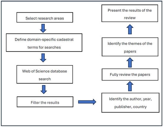
Figure 1.
The eight-step methodology used for this systematic review.
The cadastral trends selected for this study, including 3D cadastre, technical infrastructure cadastre, disaster-responsive cadastre, marine cadastre, public law restrictions cadastre, and fit-for-purpose land administration, are described in the introduction. Theme-specific keywords were used for each trend. These keywords are present in the relevant sections. The WoS search engine searched for theme-specific publications by title, abstract, and keywords. The keywords “cadastre”, “cadastral”, “cadastral system”, and “land administration” were used for all trends. Theme-specific terms are also included and explained detailed in the relevant sections on each trend. The keywords searched for relating to each trend may produce results that are irrelevant to cadastres and LA. For example, the keyword “public law restriction” may produce results from the field of law, the keyword “fit for purpose” may produce results from various fields of science, and the keyword “disaster” may produce results from the field of geosciences. Therefore, the common search terms mentioned above were used for every trend analysis. Nevertheless, there may be results unrelated to cadastres or LA. For this reason, not all of the search results are directly included in this review, and a manual selection was also carried out. The search results were restricted to 2014–2024 (including 2024). Manual elimination was performed by first reviewing the relevance of the results to the search topic and then reviewing the titles and abstracts of the studies. The global agenda is rapidly changing due to various triggers, such as population growth and technological advances. Therefore, papers published in the last decade were selected to capture and reflect the current state of trends in LA. This study is limited to English language publications and is considered more accessible to the international research community. Although a systematic literature analysis was conducted in this study, no coding or analysis models were applied to interpret thematic patterns. The study aims to identify general trends, current developments, and key findings in the literature rather than specific themes and patterns. Although the thematic coding method is particularly useful for a detailed analysis of large and diverse data, given the aims of this study, a descriptive and analytical approach was preferred. Therefore, it was deemed unnecessary to apply the thematic coding method within the scope of the study, and this literature review has been structured based on the content of the available sources. Based on the relevant search criteria, 367 articles were chosen to be analyzed in this article. Out of these, 185 were about 3D cadastres, 58 articles were about marine cadastres, 57 articles were about FFPLA, 33 articles were about technical infrastructure cadastres, 8 articles were about the cadastre of public law restrictions, and 26 articles were about disaster-responsive cadastres.
3. Current Cadastral Trends
3.1. Three-Dimensional Cadastres
Over the last few decades, urbanization and land use changes caused by economic developments and population growth across the world have increased the pressure on the limited urban land resources. The land surface has become insufficient to meet the needs of the urbanizing population, and land use dynamics have changed. The urban population built multi-storey and multi-purpose buildings and started to use the land’s surface and the land below and above it. The intensive physical use of land in the vertical direction has created complex legal relationships between different spatial units (e.g., land surface, air, marine, underground parcel, and infrastructure objects) []. This has resulted in overlapping rights in the vertical dimensions of land where different users have rights. As urban landscapes have developed horizontally and vertically and become physically and legally complex, identifying and registering property rights have become more important. Traditional LASs are 2D and only record and contain data on RRRs at the 2D parcel level [,]. These systems need to be improved for the seamless registration, protection, and management of the complex and overlapping rights in the modern world []. As a result of these requirements, the issue of 3D cadastres has become increasingly important.
Although the foundation of research and ideas on 3D cadastre was the Cadastre 2014 document published in 1998, studies gained momentum in the early 2000s []. In 2001, the FIG Commission 7–Cadastre and Land Management organized the first international workshop, the International FIG Workshop on 3D Cadastres, to promote research and realize 3D cadastral goals. A 3D cadastre can be defined as a tool for LASs to better manage and register multi-layered property RRRs in 3D space []. A 3D cadastre records and represents rights and restrictions not only on 2D parcels but also on 3D property units []. The basic building block of a 3D cadastre is the 3D parcel, which can be defined as the volume of the area on, above, or below ground that defines and represents specific RRRs. RRRs can be the property rights of a condominium unit, an easement right, or a right of superficies. A 3D cadastre represents the spatial extension of ownership boundaries in 3D property layers, facilitates the registration of RRRs, supports land development processes, provides reliable information, and can be used as data infrastructure for 3D urban models [].
A total of 185 publications containing the keywords “3D” or “three dimensions” or “3D property” or “3D real property” or “three dimensional” and “cadastre” or “cadastral” or “land administration” or “cadastral system” or “3D cadastre” or “3D cadastral” or “3D cadastral system” in their titles, abstracts, or keywords were selected for this study. This literature review is inspired by the classification system developed by [], which divides the reviewed articles into four categories: legal, technical, registration, and organizational. The technical dimension covers database management, data infrastructure, data models, geographical information systems (GISs), geometry, topology, and visualization. The legal dimension includes RRRs, easements, tenure security, subdivision, legislation, and condominium issues related to the 3D parcel. The organizational dimension is about how 3D real estate is managed and organized. The registration dimension includes 3D real estate data content, storage, structure, and maintenance []. In the field of 3D LA, there is a strong interest in issues related to standardization, 3D modelling technologies, and the preparation of 3D data infrastructure. However, visualization is one aspect that stands out and is important.
This section classifies the articles according to their main categories and topics. The topics highlighted in most of the articles and used in this review are visualization, the Land Administration Domain Model (LADM) as an international standard for land administration, and BIM and CityGML as 3D physical modelling tools.
There is an intense interest in 3D cadastral studies. In the last decade, most studies were published in 2020 (29 times). The authors who contributed the most to the articles were Rajabifard (30 times), Kalantari (23 times), van Oosterom (21 times), Atazadeh (17 times), Shojaei (13 times), and Olfat (10 times). These authors are qualified experts carrying out research into 3D LA and GISs. In particular, Kalantari, Atazadeh, and Shojaei are researchers of Building Information Modelling (BIM) as a 3D modelling tool. These experts continue their studies at various academic organizations in Australia, which has advanced technologies in the field of GISs. It is also worth noting that, if we look at the articles that deal with a country example rather than a global model proposal, we see that 3D cadastral studies are carried out much more often in Australia than in other countries (see Figure 2).
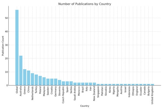
Figure 2.
The distribution of 3D cadastre publications by country.
The majority of the articles reviewed were published in leading scholarly journals in the domain, including Land Use Policy (36 articles), ISPRS International Journal of Geo-Information (32 articles), Land (15 articles), The International Archives of the Photogrammetry, Remote Sensing and Spatial Information Sciences (15 articles), ISPRS Annals of the Photogrammetry, Remote Sensing and Spatial Information Sciences (10 articles), and Survey Review (9 articles). This underscores the credibility and academic rigour of the reviewed literature.
The review shows that 167 articles addressed the technical dimension, 43 focused on the legal dimension, 17 explored the organizational dimension, and 15 examined the registration dimension of the 3D cadastre. Additionally, eight articles provided literature reviews on 3D cadastres [,,,,,,,,]. The total number of publications in these categories exceeds the total number of articles on the 3D cadastre analyzed because some articles appeared in multiple categories simultaneously.
The analyzed studies mostly focus on visualization issues and 3D data models. Some examples also combine technical and legal, organizational, or registration dimensions. Countries are trying to establish 3D cadastral systems to better manage the physical and legal 3D cadastral objects in complex urban environments. Some studies provide design recommendations for establishing 3D cadastral systems in different jurisdictions [,,,,]. Visualization is one of the essential components of an accurate and understandable representation of the legal and physical status of 3D cadastral units. It can be seen that 87 articles were about visualization. For instance, Višnjevac and Šoškić [] developed a 3D cadastral prototype based on an NoSQL database and JavaScript visualization applications. Khawte et al. [] and La Guardia and Koeva [] used Digital Twin technology for visualization applications, which is relatively new in the field of 3D cadastres. Drobež et al. [] and Campoverde et al. [] used remote sensing data, while Giannaka et al. [] and Roschlaub and Batscheider [] used LIDAR data. Moreover, airborne laser scanning data were investigated in [].
An effective and efficient 3D cadastral system is possible with a well-prepared 3D cadastral data infrastructure and data model. The 3D cadastral data model must cover legal and technical aspects, including spatial, non-spatial, and multidimensional data []. The findings or research on the 3D cadastral models may be summarized as follows: Shahidinejad et al. [] analyze 3D cadastral databases developed for storing and managing 3D cadastral data. Aien et al. [] compare existing data models (The Core Cadastral Model, FGDC Cadastral Data Content, ArcGIS Parcel Data Model, The Legal Property Object Model, ePLan and LADM). It can also be seen that 51 articles have handled LADM-related issues. Some articles presented jurisdiction-specific 3D cadastral data model prototypes based on LADM [,,,,,,]. Moreover, the LADM-based valuation information models [,,] demonstrate that LADM applies to 3D real estate valuation and taxation studies. Moreover, Kara et al. [] discuss a second edition of LADM that supports 3D elements. They indicate that integrating LADM with physical data models (e.g., CityGML, BIM, GIS, etc.) can provide a data model that supports all of the functions of any 3D LAS.
Building Information Modelling (BIM) and CityGML were found to be widely used in the reviewed research. BIM is used for the management of 3D property rights [,,,,,,,], the modelling of condominium units [], and the identification and extraction of 3D property boundaries [,], and for providing resources for legal domains [], supporting building subdivision workflows [], managing disputes in 3D properties [], visualizing 3D units [,,], and the modelling of the indoor environment []. CityGML, on the other hand, was used in 18 articles, which is lower than the number of articles that applied BIM. The analysis shows that CityGML is preferred for visualization in most articles [,,,,,,,].
The BIM and CityGML modelling tools focus more on the technical dimension of 3D spatial objects []. Researchers are developing LADM-integrated models to represent the RRRs components of these objects. The articles reviewed focus on LADM-BIM integration to support 3D LA [,], the mapping of private, shared, and private common areas in buildings [], the preparation of 3D digital cadastral models in multi-storey buildings [], 3D crowdsourced cadastral surveys [], the registration of property rights in multi-storey buildings [], standardization supporting smart cities [], and the management of easement rights []. On the other hand, the LADM-CityGML combination is used to integrate the legal and physical dimensions of the urban environment [], to model indoor legal elements by defining indoor spaces with IndoorGML-LADM integration [,], and to model the ownership structure of condominium units in 3D buildings []. Zlatanova et al. [] and Alattas et al. [] used IndoorGML, published by the Open Geospatial Consortium (OGC) in 2014, for the first time for indoor modelling in 3D cadastral studies. Unlike the others, El-Mekawy et al. [] tested both LADM-BIM and LADM-CityGML combinations to integrate the legal component into 3D cadastral systems. The study highlights the significant contribution of BIM, CityGML, and LADM standards to developing a 3D cadastre. It also emphasizes that the LADM best represents the legal characteristics and that other models should be developed in this regard.
While creating cadastral models that include the legal and physical components of 3D immovable properties, of course, the legal dimension (property data), registration dimension (registration of cadastral data in the registry), and organizational dimension (the process of creating the 3D cadastral model) should be considered. However, only some studies focus on purely the legal (two articles), registration (two articles), and organizational (four articles) dimensions without considering the technical dimension. For instance, Kitsakis and Dimopoulou [] investigate the Common Law and Civil Law provisions that may support 3D cadastres and find out that Civil Law principles support the creation of 3D property units. In contrast, Common Law principles fail to link the surface parcel with the 3D property unit. Ho et al. [] examine the social and cultural environment supporting 3D LA. Atazadeh et al. [] propose using BIM by focusing on managing the 3D environment. Stoter et al. [] present a methodology for registering property rights in multi-layered property in the case of the Netherlands. Similarly, Mika and Jurkiewicz [] investigate the legal and technological barriers to creating a 3D cadastre for Poland. In the organizational dimension category, Velastegui-Cáceres et al. [] investigate the suitability of the existing cadastral conditions of eight regions in Ecuador to create a 3D cadastre. Atazadeh et al. [] handled the registration dimension of a 3D cadastre and investigated the storage of cadastral survey data in the BIM environment. Paasch and Paulsson [] reviewed developments in 3D cadastral research between 2012 and 2020, focusing on the legal perspective on 3D property.
The results of the analysis show that there is more interest in the technical dimension of 3D cadastral studies. In the last 20 years, technologies for collecting, storing, modelling, and visualization of 3D data have evolved significantly. The articles are characterized by data modelling and visualization efforts using LADM, BIM, and CityGML standards in this context. In particular, the LADM has been commonly used to design 3D cadastral profiles of countries. However, the legal dimension and the planned land use information about the property should be further be explored in the future.
Three-dimensional properties are composed of complex condominium units covering private and communal areas. Therefore, rights and interests should be more clearly represented and managed within the internal structure of the property []. In this respect, modelling and representing RRRs are as important as modelling and representing legal spaces in a 3D LAS. On the other hand, the registration dimension, which includes the storage of 3D cadastral data and the maintenance of the system, and the organizational dimension, which consists of the management of the process, people, and institutions, can also be further considered by researchers looking at the 3D LA domain in the future. The registration and organizational dimensions are less covered in the reviewed articles than some other dimensions.
3.2. Marine and Coastal Cadastre
Marine areas cover about two-thirds of the Earth’s surface, and large populations live in coastal areas. So far, efforts and resources have been spent on effective land management. However, less attention has been paid to marine areas []. Marine and coastal areas provide significant resources for meeting the needs of the world’s growing population. Fishing and farming for food, the logistics of the transportation of people, mining, energy production, and oil and gas exploration for the economy all lead to the intensive use of marine areas. In addition, the tourism activities of countries and the construction of urbanized marine and coastal areas can also be considered as important activities conducted in marine and coastal areas. Furthermore, marine and coastal areas involve stakeholders such as the public and private sectors and citizens. These situations make marine and coastal areas important for countries’ economic, social, and environmental well-being.
Using marine and coastal areas for different purposes increases the amount of pressure on and competition in these areas. Historically, the use of marine areas concerned transportation and fishing. Today, however, the increasing diversity of activities and users creates a stratified space in marine areas, with many parties, legal relationships between the parties, and overlaps in the spatial extents of these legal relationships []. The effective planning of physical development in marine areas and the understanding and efficient management of the interaction between legal situations are complex problems []. Accurate, reliable, and comprehensive information is needed to effectively manage RRRs and their spatial extent in marine areas and to avoid conflicts. A marine cadastre is a tool that fulfils this requirement as a system that records and spatially manages rights and interests in marine areas []. The function of a marine cadastre is to record the rights of organizations and individuals, manage rights regarding marine resources and parcels, and prevent and resolve disputes []. Although the marine cadastre is a relatively new topic in international research, several studies have been published in the FIG’s proceedings [,,]. However, research on the marine cadastre as a tool for managing marine areas still needs to be improved, especially for developing countries.
A total of 58 publications containing the keywords “marine” or “coastal” or “offshore” or “water” or “marine” and “marine cadastre” or “cadastre” or “cadastral” or “marine administration” or “cadastral system” or “marine spatial data” or “land administration” in their titles, abstracts, or keywords were selected for this research.
According to the results, research on marine areas attracts great interest. The fact that many authors have contributed to this research indicates this interest. In addition, since many countries have marine areas, the research is not concentrated on specific countries. In this context, it is not possible to classify papers reviewed at the author and country scales. Most reviewed articles appear in Ocean and Coastal Management (twelve) and Marine Policy (eight). These are the leading scholarly journals in the marine domain. Countries bordering the marine zone are interested in marine and coastal cadastres. In this respect, the distribution of papers by country also varies (see Figure 3).
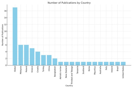
Figure 3.
The distribution of marine and coastal cadastre publications by country.
The need for food, energy, and resources has increased significantly due to rapidly growing populations, technological developments, and consumer demands. Limited and decreasing land resources, as well as the desirability of coastal areas, are increasing the use of marine and coastal areas to meet growing demands []. According to the current evidence, the unplanned use of coastal and marine areas and the ever-increasing human activities in coastal and marine areas are causing irreversible damage to marine ecosystems and biodiversity []. This threatens coastal and marine resources and the marine ecosystem’s ability to meet society’s needs []. Accordingly, national and international organizations are turning to marine spatial planning (MSP) to protect and effectively manage marine and coastal areas []. MSP is concerned with managing human activities in coastal and marine areas to ensure marine areas’ ecological, economic, and social sustainability. In the last 20 years, MSP has evolved from a concept to a practical approach []. The results of the analysis also support the importance of MSP. The common theme in the majority of papers is MSP. MSP strategies are discussed in terms of data visualization [,,,], mapping [,], and MSP approaches to development [,,,]. However, the common goal in all of the relevant articles is the conservation and sustainable use of marine and coastal areas.
Another theme discussed in the articles is marine spatial data, including data infrastructure, data models, and information systems. Marine spatial data are a key component in enabling the growth of the marine economy [] and the sustainable use of marine and coastal areas. Marine and coastal data support activities such as navigation, coastal zone management, environmental protection, and the effective use and management of marine and coastal resources []. The dynamic and multidimensional nature of the marine and coastal environment makes collecting and updating data challenging []. The marine spatial data infrastructure (MSDI), as the marine component of the national spatial data infrastructure, provides access to marine spatial data []. MSDIs are of great importance for the preparation of marine spatial plans. A broad marine data infrastructure is increasingly being developed and used to provide the data required for decision-makers in marine areas. A well-developed MSDI is directly related to effectively managing marine and coastal areas through data accessibility, interoperability, and high-quality data content [].
Marine and coastal areas display overlapping rights on the surface, in coastal waters, seabed, on the coastline, seashore and littoral area, and in coastal water bodies such as estuaries []. Marine spatial data reflect the physical extensions and nature of these rights. Marine cadastres and marine cadastral data models are used as tools for the accurate representation of these rights. Like the traditional cadastral approach, marine cadastres record legal and spatial data on the rights and interests in marine and coastal areas and define their boundaries. A marine cadastre is the primary basis for preparing marine spatial plans and MSDIs. According to the results of the analysis, only some studies directly discuss marine cadastres and marine cadastral data models. Athanasiou et al. [], Flego et al. [], Zamzuri et al. [], and Hussaini Atulukwu et al. [] discuss the development of a marine cadastral model based on the LADM. These studies also consider the tenure dimension for marine and coastal environments. Dawidowicz et al. [] discuss marine ecosystem management in the context of a marine cadastre. Michalak [] uses a marine cadastre as a tool for conflict management in energy facilities in marine areas. Dawidowicz and Kulawiak [] consider the marine cadastre as the basic infrastructure for marine geographic information systems and visualization activities.
It has been observed that the majority of the articles reviewed in this section discuss the themes of MSP and MSDI. Marine cadastres are crucial for protecting rights and interests in marine areas, reducing conflicts over overlapping rights and interests, creating legal certainty, providing revenue to governments through the taxation of the use of marine resources, and the legally binding nature of marine spatial plans []. In addition, a clear and accurate determination of the tenure rights in coastal and marine areas supports the protection and sustainable use of the marine ecosystem. In this respect, it seems necessary to evaluate legal and technical data in coastal and marine spaces as a whole and to develop a cadastral model, especially for coastal areas. It can also be stated that there is a need for further research focusing on the valuation functions of LA in marine areas.
3.3. Fit-for-Purpose Land Administration
Documenting the people–land relationship is important for societies. It is also on the agenda of international organizations such as the United Nations (UN) and the Food and Agriculture Organization (FAO). The World Bank also emphasizes the development of appropriate systems to achieve economic growth, social cohesion, and environmental sustainability []. Moreover, 11 of the 17 Sustainable Development Goals (SDGs) are land-related, and these goals will only be achieved with a well-organized LAS []. An LAS [] which contains land-related data and enables economic, social, and environmental sustainability through efficient land management can fulfil this expectation. The main focus of LASs is identifying, managing, publishing [], and protecting [] land-related RRRs.
Most developed countries have a well-established LAS with strong institutions and legal arrangements to provide individuals with secure access to land and protect land rights []. However, around 70% of the world’s population needs access to a formal LAS to protect their land rights []. A lack of formal and secure land tenure causes severe social and economic instability for poor communities, who face the threat of eviction from the land they live on [], and prevents the creation of efficient land markets. Therefore, practical approaches to address land issues in developing countries are needed. These requirements have recently led LASs to evolve to take into account the different types of land rights. This evolution has also been supported by the SDGs on land rights protection and the availability of up-to-date measurement and recording technologies such as drones, satellite imagery, handheld Global Navigation Satellite Systems (GNSSs), and cell phones [].
Intensive efforts in the search for an innovative approach to registering land tenure were conceptualized in 2014 with the introduction of FFPLA. FFPLA principles have recently been used in many countries to register and secure land rights on a large scale, in a short time, and cost-effectively []. The focus of this approach is to formally define land rights and interests, especially in developing countries, by registering or recording them with rapid and cost-effective solutions. It also supports the realization of poverty alleviation, food security, and good governance for vulnerable groups (e.g., women, the poor, older people) []. This section reviews recent research on FFPLA. A total of 57 publications containing the keywords “automatic” or “semi-automatic” or “boundary extraction” or “fit for purpose” or “fit-for-purpose” and “fit-for-purpose land administration” or “FFPLA” or “cadastre” or “land administration” or “cadastral” or “cadastral system” or “land management” in their titles, abstracts, or keywords were selected for this research.
There has been an increasing interest in FFPLA-related studies in recent years. Most studies were conducted in 2021. The reason for this is that the Land journal published a Special Issue on FFPLA in 2021. The motivation for this Special Issue was to promote the use of the FFPLA approach and share research that aims to provide fit-for-purpose solutions to land-related problems []. The authors who contributed to most of the articles were Bennett (13 times), Koeva (10 times), Zevenbergen (8 times), and Lemmen (6 times). These authors are qualified experts who generally conduct their research in the LA domain.
The articles reviewed mostly have been published in Land (twenty-nine articles), Land Use Policy (eight articles), Survey Review (five articles), and Remote Sensing (four articles), which are the leading scholarly journals in the domain. The majority of the articles (29) are related to African countries. This is followed by America (seven articles), Asia (seven articles), and Europe (five articles) (see Figure 4). The most common issues handled in the reviewed articles are cadastral data production (nine times), land registration (seven times), land tenure security (five times), and the implementation of FFPLA (five times).
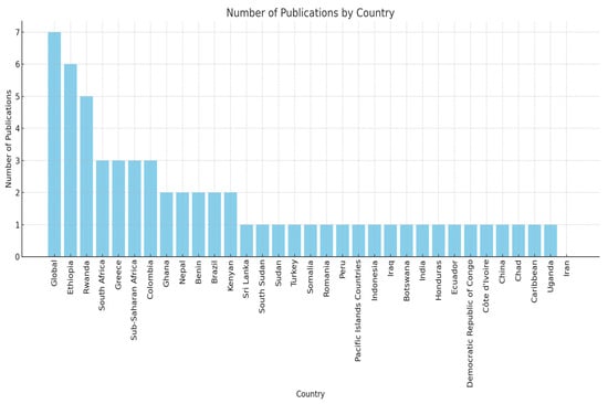
Figure 4.
The distribution of FFPLA publications by country.
FFPLA includes a set of principles for solving land-related problems within a local context. These are spatial principles (sufficient accuracy and practical techniques), legal arrangements (flexible, support for all formal and informal rights, continuity of land rights), and good governance (accessibility and simplified procedures) []. In this respect, the continuum of land rights [], the responsible governance of tenure [], and the social tenure domain model (STDM) [] should be mentioned to support the foundation of FFPLA. FFPLA refers to an approach that is flexible, inclusive, participatory, cost-effective, safe, accessible, and improvable []. The principle of fitness for purpose ensures that cadastral works focus on problem-oriented solutions and deliver rapid results. The principle of flexibility allows cadastral systems to be effectively adapted to local conditions. The principles of inclusiveness and sustainability create a robust cadastral framework that secures property rights, particularly in developing countries. Finally, the principle of improvability enables the continuous improvement and updating of cadastral systems as new opportunities arise. It has been used frequently in recent years in developing countries to register or record land rights by creating a cost-effective LAS in a short time.
While the focus of FFPLA is initially on land registration and tenure security, its use has been more expansive than these issues. In principle, this approach aims to provide fast, cost-effective, and practical solutions to existing problems. However, it is seen that FFPLA has exceeded its initial focus and has been used for different purposes. Kelm et al. [] tested the applicability of the fit-for-purpose approach for different LA functions such as land valuation, housing resilience, and waste management. In this context, innovative technologies such as drones and information extraction from street-level imagery are explored to create a cadastral dataset that can be captured once and used jointly for urban land management activities. The paper suggests that the FFPLA approach could be adopted for a broader range of LA activities and provide a common dataset. Thus, it is argued that FFPLA can provide important socio-economic benefits for cadastral activities. Gkeli et al. [] developed and tested an open-source mobile application to register crowdsourced 3D cadastral data and a 3D visualization of property units. This approach aims to save time and costs related to collecting cadastral data to prepare a visual model and design a modern, fit-for-purpose solution. The model is argued to be adjustable and applicable to developed and developing countries. The FFPLA approach also contributes to the realization of SDGs. Bennett and Alemie [] evaluate cadastral activities such as urban area studies, compensation for land acquisition for road construction, and land consolidation in the case of Ethiopia, showing that fit-for-purpose solutions support cadastral designs. This also suggests that such a design can benefit poverty alleviation, food security, and good governance in the context of sustainable development. Some articles provide recommendations based on FFPLA for LASs’ maintenance, improvement, and renewal [,,,,]. Bennett et al. [] emphasize that emerging FFPLA solutions are valuable in LA maintenance. Ercan [] proposes a fit-for-purpose model to measure the need for cadastral renewal by examining cadastral records for rural areas in the case of Türkiye. FFPLA is also used in studies involving land value and the land use functions of LA. Khezri et al. [] examine a fit-for-purpose approach to obtaining climate change and land use data; Asiama et al. [] test the use of FFPLA tools for land consolidation studies; and Reydon et al. [] use FFPLA for forest land protection studies. Koeva et al. [] utilize FFPLA solutions in tax-oriented assessment studies. In addition to these, FFPLA offers effective and efficient solutions for mapping studies [], increasing resilience against climate change and epidemics [], and thus can also support disaster-responsive cadastral activities, dealing with social conflicts and resolving land disputes [,].
Effective cadastral systems have reached their state in developed countries after long historical processes. On the other hand, many developing countries do not yet have such systems. In developing countries, much effort is put into establishing cadastral systems, yet more attention should be given to the maintenance, improvement, and updating of these systems. Thus, changes that occur over time after the initial registration are not fully and simultaneously reflected in the system. This may lead to wasted efforts in system establishment and maintenance and may not result in achieving the intended long-term benefits []. In both cases, a simple solution that is fast, cost-effective, flexible, participatory, and inclusive of all forms of land conservation is needed. In this context, the FFPLA offers innovative and pragmatic solutions. Moreover, the FFPLA approach provides a system that evolves and matures over time to deliver multi-purpose services related to land use planning, taxation, and development activities []. While the results obtained from the articles support the usefulness of FFPLA for these purposes, they also show that FFPLA can be used in a wide range of land management functions (e.g., land consolidation, climate change, forest land protection, combating epidemics, preventing social conflicts, valuation). The results obtained from the reviewed articles support the effectiveness of the FFPLA approach in realizing global agenda issues and SDGs, including social equity.
3.4. Technical Infrastructure Cadastre
The primary purpose of cadastral systems is to define, record, and secure the RRRs of land and people. Cadastral systems mostly address this relationship at the land surface level. However, rapid urbanization and intensive population growth have increased land use, especially in urban areas, and necessitated optimum land use. Therefore, using the space under the land surface has gained importance. For many decades, public utilities such as electricity, water, sewerage, gas, and communication infrastructure, which are essential components of urban life, have been located under the land surface. However, with the drivers mentioned above, underground spaces have been used to install more complex infrastructure facilities such as subways, shopping malls, and parking lots.
With the intensive use of underground spaces, the need for information on the location of facilities below the surface and where new facilities will be built has become important. Information on public utilities is rarely, or often not, recorded. However, the lack of data and information on the physical size of these facilities leads to significant accidents and damages []. For example, the United States Pipeline and Hazardous Materials Safety Administration reported approximately USD 12 billion in damages over a 20-year period []. There are complex property rights, restrictions, and liability gaps underground. In terms of the LAS, the planning and management of underground facilities requires the accurate and reliable identification of information on legal rights and interests. Rajabifard et al. [] argue that the reliable and precise identification of legal areas can reduce unnecessary project costs and prevent delays and disruptions. The effective management of underground spaces is also needed as an essential component ensuring the sustainable development of urban areas []. A technical infrastructure cadastre or utility cadastre is an essential tool for identifying, recording, and presenting physical and legal information about underground spaces. The main registry records the RRRs related to underground spaces and the basic physical information about public utilities [].
A total of 33 publications containing the keywords “utility network” or “infrastructure” or “underground” or “gas” or “pipeline” or “road” or “transport” or “telecommunication” and “cadastre” or “cadastral” or “cadastral system” or “land administration in their titles, abstracts, or keywords were selected for this research.
According to the results of the analysis, most studies were conducted in 2023 (five articles), 2022 (four articles), and 2021 (four articles). The authors who mostly contributed to the articles were Atazadeh (eight articles), Rajabifard (seven articles), Saeidian (six articles), and Kalantari (six articles). Although these authors have different countries of origin, all of them carry out their academic work in Australia. They are experts in the domain of LA and spatial data infrastructure. Most of the articles reviewed have been published in Land Use Policy (seven articles), Land (four articles), and Tunnelling and Underground Space Technology (four articles), which are the leading scholarly journals in the domain. Australia is analyzed six times in the articles, while five papers refer to jurisdiction-independent context. In addtion, China and South Korea are analyzed four and three times, respectively (see Figure 5).
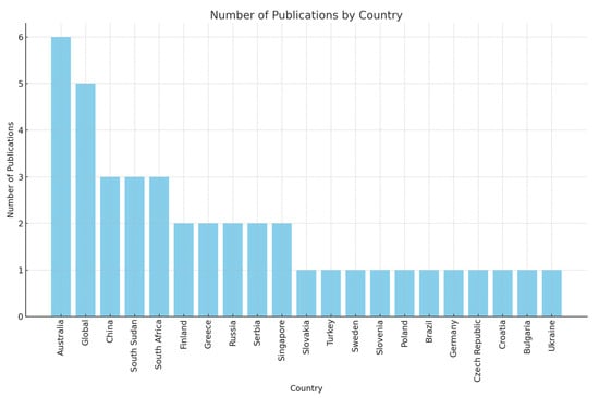
Figure 5.
The distribution of technical infrastructure cadastre publications by country.
The conclusions drawn from the reviewed articles can be explained as follows: A common use of infrastructure space is for the provision of public utilities. In some jurisdictions, these utilities are the sole responsibility of the public sector, while in others, they are provided jointly by public and private organizations. The responsible organization also records spatial data associated with the utilities. In this respect, there are uncertainties and inadequacies in developing a common cadastral model for infrastructure. Nowadays, underground spaces are also used for purposes other than public utilities (e.g., shopping malls, car parking, subways, etc.). This leads to a complex physical configuration underground. The definition and recording of the legal status of underground objects is mostly carried out in the form of easements []. However, the definition of an easement needs to be revised when it comes to underground real estate or parcels. Therefore, there is a need for clear, accurate, and reliable identification and registration efforts for all underground property. According to the results of the analyses, the number of articles dealing with the legal aspects of infrastructure facilities is less than the number of articles dealing with the technical and physical aspects. Today, when we look at the use of underground space in cities, there is a significant level of tenure conflict. Each time a physical facility is constructed, a new legal set of RRRs arises. In this respect, the legal aspects of infrastructure facilities should be given due consideration.
Underground spaces and the immovable properties of these spaces are 3D and cannot always be represented on a 2D plane. Underground, as in the air space, there is a layered structure, and as a result, layers of tenure are formed. However, existing 2D cadastral systems mostly represent the subsurface with 2D plans. However, 2D plans lead to various problems such as legal (e.g., boundary disputes), economic (e.g., accidents and damages in infrastructure works, delays in projects, financial losses), and planning (e.g., urban planning) problems []. In this respect, there is a need for a 3D infrastructure cadastral model to record underground cadastral data and ensure the security of tenures accurately. However, a 3D cadastral data model covering all underground utilities has not yet been developed []. Evaluating infrastructure facilities in terms of 3D technologies is a relatively new phenomenon. The results of the analysis also support this. Indeed, many of the analyzed articles (especially those published in the last few years) associate infrastructure cadastres with 3D cadastres and 3D modelling tools (e.g., CityGML, BIM, LADM). In particular, the primary authors (e.g., Atazadeh, Kalantari, Rajabifard), who are experts in 3D cadastres, have made significant efforts to produce 3D infrastructure LA models using CityGML, BIM, and LADM.
Some underground facilities may also be subject to property taxation and, hence, require valuation. They may also need evaluating for risk assessment processes, insurance, etc. Therefore, the determination of the value of these facilities is also important. When the articles are analyzed in this respect, it can be seen that very few articles [,,] focus on the fiscal or economic aspects of infrastructure facilities. Moreover, it should be emphasized that legal regulations need to be made to effectively manage facilities and immovable properties underground. Looking at the reviewed papers, only [] propose legal regulations addressing the infrastructure facilities’ legal aspects. The articles are more interested in the transportation category (e.g., metro) of public technical infrastructure facilities [,,,,]. Other facilities such as electricity, water, and telecommunications are considered as a whole within the volumetric underground space.
In conclusion, it should be noted that utility or technical infrastructure cadastres are generally evaluated in terms of their technical and physical aspects in the reviewed articles. It is possible that advances in 3D modelling, standardization, and GIS technologies have had a significant impact on these studies in the field of LA. However, it was found that there are few papers evaluating the legal aspects. in addition, it is can be seen that the value aspect is the least discussed LA component in the reviewed articles. In this respect, it is expected that future studies may also focus on addressing the legal and value dimension of the utility or technical infrastructure cadastre.
3.5. The Cadastre of Public Law Restrictions
In recent decades, human activities have greatly affected urban and natural areas. Population growth, the intensive exploitation of land, and the expansion of the built environment have led to the development of multi-layered, overlapping, and interconnected physical spaces and complex property rights and constraints. RRRs related to property are important components of LASs. Provisions related to the legal elements of property are regulated by national legislation []. The use of property rights can be restricted in the interests of public or private stakeholders []. Restrictions have an important place in terms of the disposal of property rights and the use of properties at individual and societal scales. Property rights and restrictions are regulated under private and public law []. Private law aims to regulate land use and property relations to prevent conflicts between owners []. Private law restrictions on property include easements, mortgages, leaseholds, and superficies [] and are related to both rights holders and obligors []. Public law is the norm that restricts the use of property in the public’s interest within the framework of public interventions and measures related to the protection of land and natural resources []. It supports expanding the national economy and social policies and aims to protect the public’s interests, health, and safety []. Public law covers significant applications such as mining, cultural heritage, environmental and natural resource protection, urban planning, public services, and easements [] and concerns all persons in the public domain [].
Administrative authorities aim to protect the public’s interests in intensive land use, property development, and the formation of property rights. In this context, they impose a series of administrative restrictions and regulations on property rights and interests, so-called PLRs, based on the principle that public interests are above personal interests. In today’s societies, PLRs in various fields are increasing and becoming more complex, putting pressure on LASs []. This necessitates developing and integrating domain-specific cadastral models, such as a PLRs cadastre, into LASs to record and model PLRs effectively. There are initiatives in many European countries (e.g., Switzerland, Spain, Slovenia) to record and manage PLRs for various purposes such as archeological site preservation, environmental conservation, groundwater protection, pollution, and waste site recording and management. Switzerland is one of the pioneers in this field, developing the cadastre of PLRs [], while Spain is adding some PLRs as parcel attribute information and using them in valuation studies []. Slovenia registers PLRs in a separate registry [].
A total of eight publications containing the keywords “public law” or “public law restriction” and “cadastre” or “cadastral” or “cadastral system” or “land administration” in their titles, abstracts, or keywords were selected for this review.
In particular, the Greek scholar Kitsakis has made significant contributions to the cadastre of PLRs. The common theme of these studies is to reveal all or a specific part of the PLRs that are effective on properties according to the relevant legal regulations. Most PLRs have 3D features and are assessed in a 3D environment []. Kitsakis and Dimopoulou [] also investigate PLRs applied in 3D space and their management in the context of 3D cadastres. Kitsakis et al. [] investigates the contribution of 3D modelling to the management and implementation of PLRs and present the advantages and disadvantages of BIM/IFC and CityGML 3D modelling tools in managing 3D PLRs. According to this, BIM/IFC effectively models restrictions based on buildings and structures, whereas CityGML is more effective in managing restrictions that apply at the urban scale and concern physical entities. Kitsakis and Dimopoulou [] identify 3D PLRs in the Trans Adriatic Pipeline (TAP) project and reveal the characteristics of 3D PLRs defined in Environmental Impact Assessment (ESIA) studies. Kitsakis et al. [] provide an overview of the legal and technical aspects of PLRs in the context of 3D LASs, discussing their characteristics, classification, modelling, management, integration into LASs, their 3D scope, and how they are addressed and regulated according to the legal family to which they belong. Paasch et al. [] provide an extension of the LADM to a more detailed classification of the LA_RRR package. Yıldız [] presents a model based on the LADM for the restrictions on the sale of agricultural land in Türkiye. Aydinoglu and Bovkir [] identify the restrictions applied in urban areas of Türkiye and propose a PLR model integrated into the Turkish National Geographic Information System. Petrakovska et al. [] also aim to ensure the legal component of land rights and social welfare by identifying the factors that influence the size of the land use restrictions zone. The distribution of the papers by country is shown in Figure 6. A common conclusion that can be drawn from the reviewed studies is the need for a detailed identification of PLRs and the establishment of a PLR registry integrated into LASs.
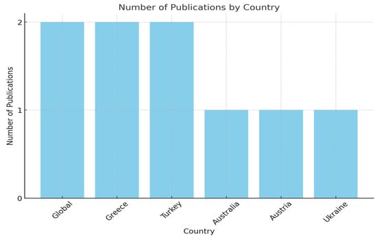
Figure 6.
The distribution of PLR cadastre publications by country.
PLRs are diverse and varied. Since PLRs are regulated and managed by different institutions, their management is complex. In this respect, PLRs are not easy to identify and model. Furthermore, the high-priority of studying national land management systems also influence researchers’ interest in studying PLRs. These are likely the reasons why there are few studies in the field of PLR cadastres.
3.6. Disaster-Responsive Cadastre
Over the last century, the world has faced, and continues to face, significant challenges. These include energy shortages, climate change, food shortages, urban growth, environmental degradation, and disasters []. Disasters are events that significantly affect the functioning of society by causing extensive human, material, economic, or environmental losses, and the affected area is unable to cope with its resources alone []. The FIG [] divides disasters into natural disasters (e.g., earthquakes, mass movements, hurricanes, floods, droughts, tsunamis, etc.) and technological disasters (e.g., industrial pollution, nuclear activities, industrial or technological accidents, etc.). A total of 4212 disasters between 1980 and 1999 affected 3.25 billion people, killed 1.19 million people, and caused USD 1.63 trillion in economic damage. A total of 7348 disasters between 2000 and 2019 affected 4.03 billion people, causing 1.23 million deaths and 2.97 trillion dollars in economic damage []. Earthquakes and floods are the most common disasters, followed by landslides, hurricanes, tsunamis, and fires [].
National governments and international organizations and institutions have increased their interest in Disaster Risk Management (DRM) studies in order to evaluate all aspects of disasters []. The purpose of DRM is to develop policies and actions to reduce risk factors and to manage the immediate response in the case of a disaster. DRM consists of three phases: pre-disaster (risk assessment and resilience building), during the disaster (rescue and emergency relief), and post-disaster (damage assessment and reconstruction) []. DRM is a challenging field that requires effective methods and techniques to address conditions related to different types of disasters.
Disasters are directly related to properties. A disaster–property relationship includes the impacts of disasters on property attributes and the efficient management of these impacts. Therefore, DRM includes a property component and needs disaster-specific spatial and non-spatial information on the properties at all stages. LA and its core element, the cadastre, includes information on land tenure, land use and control, the property market and property values, property development, and environmental management within the framework of the human–rights–land relationship [].
The National Risk Index Technical Documentation published by the Federal Emergency Management Agency (FEMA) includes 18 different disaster types (coastal floods, cold waves, drought, earthquakes, hail, heat wave, hurricane, ice storm, landslide, lightning, river floods, high wind, tornado, tsunami, volcanic, activity, wildfire, and winter weather) [].
A total of 26 publications containing the keywords “hazard” or “disaster” or “risk” or “responsive” and “land administration” or “cadastral” or “cadastre” or “cadastral system” in their titles, abstracts, or keywords were selected for this research.
The themes of the articles are classified as LA for disaster management and resilience, LADM in disaster management, climate change and social resilience, GISs, databases, and digital cadastres for DRM, urban development and sustainability, and policy and planning themes. Moreover, the disaster–cadastral relationship presented in the articles is evaluated according to the components of LA (i.e., ownership, land use, value, and land development).
According to the results of the analysis, most of the studies were conducted in 2017. The authors who contributed the most to the articles were Bennett (six times), Unger (four times), and Zevenbergen (four times). The countries of origin of the corresponding authors are Australia and the Netherlands, respectively. Australia is a country where natural disasters are common, and it can be said that this situation may be an incentive for the author to be interested in disaster-related studies. Both countries also have well-developed LASs.
The articles reviewed are published in Land Use Policy (seven articles), Land (four articles), and Remote Sensing (two articles). The distribution of the countries related to the articles in alphabetical order is Australia (one), the Caribbean (one), Croatia (two), Haiti (one), India (one), Malaysia (one), Nepal (one), the Netherlands (one), New Zealand (one), the Philippines (one), Poland (two), Romania (one), Serbia (one), South Korea (one), Spain (one), and the United States (one) (see Figure 7). The countries mentioned here are either in disaster-prone districts or have experienced significant disasters. Therefore, these countries need effective DRM mechanisms integrated into the cadastral systems. This need is also evident from the themes of the articles. Indeed, LA in disaster management and resilience is the most frequently mentioned theme, with 23 articles. The use of the LADM in disaster management (five articles), climate change and social resilience (three articles), GIS, databases, and digital cadastre for DRM (six articles), urban development and sustainability (four articles), and policy and planning (two articles) are also mentioned. While DRM systems are well served in developed countries (e.g., The Netherlands, Australia, the United States, etc.), this differs in developing countries (e.g., Nepal, Haiti, the Philippines, Romania, etc.). This may be dependent on the level of development of the LAS of a country. DRM can only be expected to succeed in jurisdictions with an effective cadastral system or LAS and adequate property information.
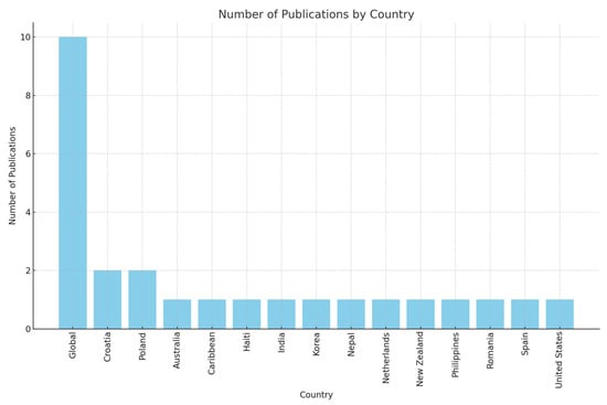
Figure 7.
The distribution of disaster-responsive cadastre publications by country.
The most frequent type of cadastral data mentioned in these articles are land use data, which are mentioned 22 times. This is followed by ownership data, which are the subject of 14 studies, land development data, 11 times, and value data, 4 times. Land use information is mainly used to create a disaster-resilient environment and is also needed in other stages of a disaster. A risk assessment based on cadastral data enables informed land use planning to mitigate potential hazards by identifying risky areas []. These can be said to be the reasons why land use data are used the most in the articles. According to the reviewed articles, the ownership data provided by the cadastre are also critical in disaster studies. The FAO [] also supports this by stating that cadastres are significant inventories of official property rights documents before disasters. The reviewed articles also emphasize that informal tenure is vulnerable to disaster [,]. This is often the case in countries that need a well-functioning cadastral system. Therefore, FFPLA is proposed [,]. Other LA data, such as value information and land development information, are presented in four and eleven articles, respectively. The material impact of disasters is considerable. In this respect, land development information to increase resilience to minimize material damage and value information for post-disaster damage assessment and possible compensations are crucial.
We can evaluate some of the cadastral information used in DRM in three stages within the framework of the disaster–cadastral relationship. Information on land use and physical characteristics of a property can support the identification of physical and environmental components in a risk assessment processes [,]. Accurate and reliable information is also needed during a disaster. At this stage, cadastral data facilitate emergency disaster responses []. Finally, in the post-disaster phase, a cadastral data infrastructure is needed for property value data to determine economic damage [,], land use data are needed for the construction of new settlements, and ownership data are required to resolve possible border disputes []. In this respect, a conceptual relationship between LA and DRM is feasible through the human–land–disaster and exposure–damage–hazard frameworks []. A disaster-responsive cadastral registry in the context of DRM-LA integration can support the realization of successful DRM and the mitigation of disaster impacts. The data infrastructure required for such a registry can also be established through the LADM [,].
Most articles evaluate the disaster–property relationship at the LA scale [,,,,]. The reason for this may be that DRM includes not only data but also policy and decision-making processes, and in this respect, integration at the cadastral scale would not be appropriate. However, the cadastre provides the basic property unit, and cadastral data are needed for effective DRM. Therefore, the role of cadastral systems and cadastral data in LA-DRM integration is critical. The results of the studies highlight the importance of LA in the realization of successful DRM. However, although cadastral data are important for both systems, they need to be given more attention. In this context, it may be recommended that future studies investigate the cadastral data required for specific disasters and DRM phases in detail and give more importance to the creation of a disaster-sensitive cadastral registry associated with value and land development information.
4. Discussion
Among the trends analyzed, most publications are in the field of 3D cadastres. This is followed by marine and coastal cadastres, FFPLA, technical infrastructure cadastres, disaster-responsive cadastres, and PLRs cadastres, respectively. These studies mostly focus on technical aspects (e.g., data modelling, management, visualization). It is also observed that the ISO LADM is more widely used than international standards such as BIM/IFC and OGC CityGML. The results emphasize the importance of 3D cadastres and the LADM for the LA community.
Global factors such as sustainable development, climate change, globalization, technological advances, and economic reform are changing the human–land relationship []. New people–land interaction patterns require the modernization of existing LASs and cadastral infrastructures to meet changing needs. In response to this demand, the United Nations Committee of Experts on Global Geospatial Information Management (UN-GGIM) published the Framework for Effective Land Administration (FELA) in 2020 as a comprehensive guideline. The FELA is a reference framework for developing, strengthening, reforming, and modernizing the LASs, considering national priorities and circumstances. The FELA’s guiding principles are based on the 2030 Agenda for Sustainable Development with its people, planet, prosperity, peace, and partnership components and the four key components of LA (land tenure, land use, land value, and land development) []. In this respect, the FELA considers modern LASs broadly, including a wide range of dimensions (i.e., economic, social, environmental, organizational, etc.). This is different from the general theme of this study, which focuses on modern LASs in terms of current cadastral trends and developments. In other words, this article reviews the state of the literature on current cadastral trends and presents the orientation of the international cadastral community in light of modern LA.
The thematic literature was searched separately for each cadastral technique identified in the article. With the 3D nature of the earth and the inability of 2D cadastres to manage the intensive use of the space above, in, and below the land and in the marine environment, the need for 3D information and the developments in 3D modelling technology have increased the interest in 3D cadastre. Since the early 2000s, 3D cadastres have attracted much attention from the international land administration community and across numerous contexts. The FIG has addressed this interest and has organized multiple workshops and Special Issues in various journals dedicated explicitly to the 3D cadastre. In this respect, it is not surprising that 3D cadastres have the highest number of papers among the different cadastral trends.
The results indicate that the 3D cadastre trend is closely linked to other emerging trends, emphasizing its critical role and the need to transition from traditional 2D cadastral approaches to 3D cadastres. Among these, technical infrastructure cadastres and PLRs cadastres are the most frequently associated with 3D cadastre, based on the proportion of relevant articles. However, the existing 2D LASs in most jurisdictions hinder the registration of infrastructure facilities and obstruct the effective management of ownership dimensions for these facilities [,]. The articles reviewed suggest that a 3D representation of the subsurface environment helps resolve the legal and physical complexities of infrastructure facilities, reducing conflicts and making these relationships more explicit. Similarly, PLRs are often implemented in 3D environments and should be evaluated in 3D to better understand their impact on properties []. Despite its importance, the cadastre of PLRs has the fewest number of studies in the past decade. The growing number and complexity of PLRs and overlapping responsibilities of different legislations and institutions (e.g., environmental protection, cultural heritage, urban planning, and public service construction) present significant challenges. Furthermore, PLRs involve both geometric and non-geometric definitions, complicating research efforts []. The varying priorities of national LA institutions also influence the limited focus on PLRs []. These factors likely account for the small number of studies on PLR cadastres in the reviewed literature.
Three-dimensional cadastres are also linked to trends such as marine cadastres, disaster-responsive cadastres, and FFPLA. However, these associations are less prominent than the technical infrastructure and PLR cadastre trends. The reviewed articles suggest that the concept of a cadastre for marine and coastal areas still needs to be fully developed. Most studies focus on spatial planning approaches and building a spatial data infrastructure for managing marine areas. The successful execution of marine spatial planning processes depends heavily on understanding and using appropriate tools to collect relevant data. Despite this, marine and coastal cadastres and cadastral data are often overlooked in planning and data infrastructure-related research. As the foundational layer for the effective management and planning of marine and coastal areas, the cadastral structure is essential for establishing spatial data infrastructure. A marine and coastal cadastre plays a vital role in protecting rights and interests in marine areas, mitigating conflicts over overlapping rights, ensuring legal certainty, generating government revenue through resource valuation and taxation, and creating legally binding marine spatial plans [].
Disaster management from an LA perspective is a relatively new area of study, which explains the limited number of articles published on the topic. Most of the reviewed studies examine the relationship between disasters and property at the LA scale. This may be because disaster risk management (DRM) encompasses not only data but also policy and decision-making processes, making its integration at the cadastral scale challenging. However, access to property and RRRs information, such as cadastral data, is critical at all stages of the disaster management process, from pre-disaster preparedness to post-disaster recovery []. Integrating the cadastre into the disaster management process can offer substantial benefits.
FFPLA is also prominent among the trends examined. FFPLA has emerged to address issues related to land registration and mapping. Moreover, the studied articles have shown that FFPLA has also been used in different LA activities such as valuation and waste management [], poverty alleviation, food security, and effective land governance [], forest area conservation [], increasing societal resilience to climate change and pandemics [], disaster management [,], and real estate valuation for taxation purposes []. These findings demonstrate FFPLA’s adaptability to diverse land-related issues and growing importance in LA. Maintaining and updating existing cadastral systems poses a significant financial burden for many economies. FFPLA methods, such as automatic and semi-automatic information extraction from imagery, offer practical and efficient solutions for sustainably maintaining and updating cadastral infrastructures in specific contexts []. However, few studies have explored FFPLA solutions for maintaining and updating existing cadastral systems. Given current global economic challenges, the FFPLA approach presents a valuable opportunity with affordable and cost-effective solutions. FFPLA shares key characteristics with the FELA approach but serves different purposes. While FFPLA focuses on providing short-term, rapid, low-cost, and flexible solutions for priority LA issues in developing countries, the FELA offers long-term, systematic solutions applicable to all jurisdictions. FFPLA and FELA approaches can complement each other, delivering effective results; however, the FELA is generally more comprehensive and large-scale. Notably, the FELA approach is not mentioned in the reviewed FFPLA papers.
The results of the analysis show that there have been significant efforts in the modelling and standardization of cadastral data. For this reason, there is a growing interest in internationally popular modelling standards. In total, 143 articles mention the ISO LADM (73 times), ISO BIM/IFC (44 times), OGC CityGML (25 times), OGC IndoorGML (4 times), and OGC LandInfra (1 time) data standards. The LADM and BIM-IFC are widely used in the field of 3D cadastres. BIM provides semantically rich and detailed modelling for 3D buildings [], while the LADM offers an advanced mechanism for representing and managing RRRs []. In addition, 3D BIMs can contribute to PLRs data management in the field of PLR cadastres by enabling the establishment of spatial relationships and queries []. The LADM can make managing the legal components of PLRs more convenient through its administrative package. However, [] states that there are various PLRs in different jurisdictions, so standardization on an international scale is challenging. It would be more appropriate to manage PLRs with the LA_Restriction class. The LADM has also been involved in a few studies in the field of marine cadastres. To manage and model various RRRs in marine areas, the LADM-based marine cadastre can support RRRs and include stakeholder information in the marine environment [,]. In addition, the S-100 Universal Hydrographic Data Model [] and the S-121 Maritime Limits and Boundaries (MLBs) Standard [] published by the International Hydrographic Organization (IHO) provide a comprehensive modelling approach to support the establishment of a marine cadastre [] and facilitate interoperability in the marine domain []. However, only 2 out of 58 articles mention a marine data model and marine cadastre based on IHO standards. It is noteworthy that ISO 19152-1:2024, the first published standard within the LADM Edition II, stated that land includes water, air, and space. Furthermore, ISO 19152-3 Marine Georegulation, which was published as an international standard in July 2024, addresses the information structures related to the management of legal spaces (such as the international maritime limits and boundaries, marine living and non-living resources management areas, marine conservation areas, etc.) and their related rights and obligations []. In fact, the IHO S-121 is built upon ISO 19152:2012, and ISO 19152-3 is a derivation developed under a cooperative agreement with the IHO, based on S-121 []. On the other hand, CityGML is one of the standards used in studies for the development of physical building models. Although it is less widely used than BIM in general, it is commonly used in the field of technical infrastructure cadastre. While BIM offers detailed modelling for a single building, CityGML is seen as a better choice for modelling structures such as public services and tunnels at the city scale []. The Land and Infrastructure Conceptual Model (LandInfra) and the Model for Underground Data Definition and Integration (MUDDI) conceptual models published by the OGC as international standards also deal with infrastructure data management. LandInfra includes the physical components of underground facilities but also considers the ownership elements related to land and buildings []. MUDDI defines the data structure and data models for infrastructure information []. However, LandInfra and MUDDI conceptual models are not included in articles on technical infrastructure cadastre in the spanned years.
The value function of LA is noticeably underrepresented in the analyzed papers, with only 5 out of 367 studies addressing the value component and real estate valuations. However, this aspect is critical in key areas such as establishing a controllable property market, preventing tax losses, fostering a fair and equitable taxation system, and achieving economically sustainable development goals. In this context, property value is a critical component of LA []. The value issue has recently garnered attention from the 3D Cadastre and LADM working groups. The LADM is currently undergoing revisions, with efforts focused on developing a valuation extension. Once ISO 19152-4 Valuation information is published as an international standard, it is anticipated that interest in valuation may grow, leading to more studies on the development of LADM-based country valuation profiles [].
5. Conclusions
LASs are designed to address the evolving needs of society. The dynamic demands and shifting priorities of modern societies have given rise to various land-based activities. Consequently, LASs are being modernized to incorporate cadastral trends to manage these diverse land-based activities. This study provides a detailed analysis of the literature on current cadastral trends from a modern land administration perspective, focusing on publications from 2014 to 2024 (inclusive) in the Web of Science (WoS) database. The research is driven by the need to present the current state of knowledge in cadastral trends. It aims to explore the interests of the LA community and examine the issues addressed in existing research. However, the study does not propose a new model for developing modern LASs.
This study analysis the trends of 3D cadastres, technical infrastructure cadastres, marine cadastres, PLRs cadastres, FFPLA, and disaster-responsive cadastres. Over the last ten years, 367 articles have been published in the WoS database, with the largest number of articles being in the field of 3D cadastres (185 articles). This is followed by the marine and coastal cadastres (58 articles), FFPLA (57 articles), technical infrastructure cadastres (33 articles), disaster-responsive cadastres (26 articles), and public law restrictions cadastres (8 articles) (see Figure 8). The authors who contributed the most publications are Rajabifard (39 times), Kalantari (30 times), Atazadeh (26 times), van Oosterom (22 times), Bennett (19 times), and Shojaei (13 times). The articles are mostly published in Land Use Policy (62 times), Land (42 times), ISPRS International Journal of Geo-Information (33 times), The International Archives of the Photogrammetry, Remote Sensing and Spatial Information Sciences (16 times), Ocean and Coastal Management (12 times), ISPRS Annals of the Photogrammetry, Remote Sensing and Spatial Information Sciences (11 times), and Remote Sensing (6 times). Among these statistics, it is noteworthy that none of the authors listed above have been involved in articles published on marine and coastal cadastres. Within the last 10 years, most of the studies were published in 2021 (70 articles) and the lowest number of studies was published in 2014 (14 articles) (see Figure 9). Looking at the country distribution of the publications, Australia is the most frequently evaluated country (31 times), followed by Greece (24 times), China (18 times), Poland (16 times), Turkey (16 times), Croatia, and Malaysia (12 times each) (see Figure 10).
Figure 8.
Distribution of total papers related to cadastral trends in the analyzed literature.
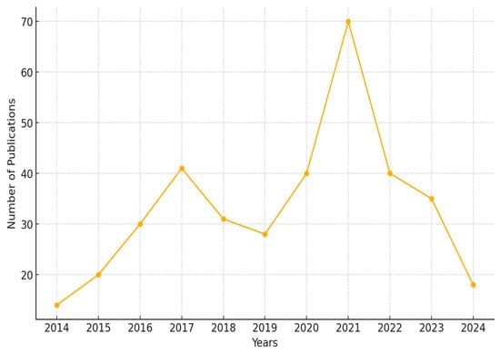
Figure 9.
Publications per year.
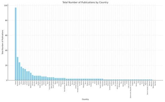
Figure 10.
The country distribution of the publications.
Three-dimensional cadastral research started in the early 2000s and continues intensively today with the support of international organizations such as FIG. This is an expected result, as it is difficult to efficiently carry out cadastral surveys with 2D LASs in environments with overlapping rights and complex physical structures. The PLR cadastre is the least researched trend among those studied. This is due to the large number of restrictions specific to different jurisdictions and the difficulty of modelling these areas. The 3D cadastre is found to be strongly associated with other cadastral trends. In particular, the 3D cadastre is widely used in the technical infrastructure cadastre and the PLR cadastre. Although the 3D cadastre is used in other trends, the number of such studies is relatively small compared to the total number of studies published on those trends. It can be assessed that the development of associated data models for each cadastral trend and the realization of interoperable and effective data management can contribute to cadastral studies within the jurisdiction and across jurisdictions, as standards are used seriously in the studies analyzed. This is evidenced by the use of BIM/IFC and CityGML, and, in particular, LADM, in many of the studies reviewed. As LADM Edition II is expected to include all of the functions of LA, it can be assumed that the LADM can provide a holistic framework for land ownership, value, use, and development.
The literature analysis shows that the LADM and 3D cadastres are important for the LA community. While the 3D cadastre is necessary for property registration and efficient management, the LADM can provide an important basis for subsequent land-based studies by ensuring the standardization of LA. From the perspective of Cadastre 2014, the main subject of a cadastre is the legal components of property management []. A categorization according to legal, technical, organizational, and registration dimensions was only carried out for the 3D cadastre out of the trends reviewed. Such a categorization can also be considered for other trends specific to the Conclusions section. In the marine cadastre trend, Athanasiou et al. [] and Yavuz Ozalp and Akıncı [] address legal aspects, Flego et al. [] address registration aspects, and Baser and Bıyık [] and Conti et al. [] address organizational aspects. In contrast, other studies address technical aspects such as developing a marine spatial data infrastructure, marine spatial planning, visualization, and GISs. Flego and Roić [] consider registration and legal aspects, and Chang et al. [] consider legal, registration, and organizational aspects together. In a categorization of the FFPLA trend, it can be seen that the technical dimension is most often discussed (twenty-one articles); as for the other dimensions, the legal and registration dimensions are discussed in six articles, the organizational dimension in nine articles, and the legal-registration dimensions together in two articles. In the case of the trend of technical infrastructure cadastres, it can be seen that studies pay attention to other dimensions along with the technical dimension. Dželalija and Roić [], Buda et al. [], and Kim and Heo [] address the registration dimension; Zhang et al. [], Karabin et al. [], and Zhang et al. [] address the legal dimension; and Vähäaho [] and Peng et al. [] address the organizational dimension. In addition, refs. [,,,,,] evaluate legal and technical dimensions, ref. [] evaluates legal and registration dimensions, and refs. [,] evaluate the legal, technical, and organizational dimensions together. Other studies focus on the technical dimension. The PLRs cadastres trend naturally focuses on the legal restriction dimension. There are few studies related to this trend. These studies address both the technical and legal aspects by combining PLRs with a 3D cadastre or LADM. The studies on the trend of disaster-responsive cadastres also focus more on the organizational dimension in the context of integrating LA with disaster risk management efforts. This context is associated with technical dimensions such as 3D cadastres and LADM, and various proposals are presented for the disaster management process. In addition, Griffith-Charles [] addresses the registration dimension by proposing an FFPLA-oriented registration approach for post-disaster recovery. Usamah et al. [] emphasize the importance of tenure in high-disaster-risk areas, while Mitchell et al. [] address the ownership component for a climate change-resilient urban environment. These studies address the legal dimension.
The analyzed studies mostly address the technical dimension. In this context, it may be expected that in future studies on the cadastral trends, in addition to the technical dimension of the cadastres, the legal ownership and value components may be further investigated. It should also be kept in mind that disasters are an increasingly significant threat on a global scale today. Developing a disaster-responsive cadastre registry is essential to cope with this threat and minimize the damage it causes. It may be indicated that there is a gap in the literature in this area. Furthermore, PLRs are as crucial as private law restrictions and have a significant effect on ownership as a component of property restrictions. However, according to the literature analyzed, there is also very little research in this area. Based on this, future studies can be expected to take this into account and further investigate the relationships between disasters and cadastres and public law restrictions and cadastres. Finally, this study is based on the WoS database only, in order not to increase the volume of research. In future work, the Scopus database could be used to extend the research, which may lead to a more holistic review. In addition, non-English publications may also be considered in future work in order to eliminate the geographical bias of this review.
Author Contributions
Conceptualization, B.U., V.Ç. and A.K.; methodology, B.U.; formal analysis, B.U. and A.K.; investigation, B.U.; resources, B.U.; writing—original draft preparation, B.U.; writing—review and editing, B.U., V.Ç. and A.K.; visualization, B.U.; project administration, B.U., V.Ç. and A.K. All authors have read and agreed to the published version of the manuscript.
Funding
This research received no external funding.
Data Availability Statement
The original contributions presented in the study are included in the article, further inquiries can be directed to the corresponding author.
Acknowledgments
The authors would like to acknowledge that this paper is submitted in partial fulfilment of the requirements of the first author’s PhD degree at Yildiz Technical University.
Conflicts of Interest
The authors declare no conflicts of interest.
References
- Bell, C.K. Good Governance in Land Administration and Management. In Proceedings of the FIG Working Week, Hong Kong, China, 13–17 May 2007. [Google Scholar]
- Palmer, D.; Fricska, S.; Wehrmann, B. Towards Improved Land Governance; FAO: Rome, Italy; UN-HABITAT: Nairobi, Kenya, 2009; Available online: https://openknowledge.fao.org/items/d2ec8fc0-999e-41df-bf2b-87eeb7fccea7 (accessed on 10 July 2024).
- Paulsson, J.; Paasch, J.M. The Land Administration Domain Model—A literature survey. Land Use Policy 2015, 49, 546–551. [Google Scholar] [CrossRef]
- United Nations Economic Commission for Europe (UNECE). Land Administration Guidelines: With Special Reference to Countries in Transition; Economic Commission for Europe, United Nations: New York, NY, USA; Geneva, Switzerland, 1996; Available online: https://unece.org/housing-and-land-management/publications/land-administration-guidelines-special-reference-countries (accessed on 19 June 2024).
- Drobež, P.; Fras, M.K.; Ferlan, M.; Lisec, A. Transition from 2D to 3D Real Property Cadastre: The Case of the Slovenian Cadastre. Comput. Environ. Urban Syst. 2017, 62, 125–135. [Google Scholar] [CrossRef]
- Enemark, S. Global Trends in Land Administration. In Proceedings of the First International Conference of the Arab Union of Surveyors, Beirut, Lebanon, 29 June–1 July 2009. [Google Scholar]
- Grzelka, K.; Bydłosz, J.; Bieda, A. Is More Always Better? Perceptions of Property Data Visualization in 2D and 3D, in the Context of Smart Communities and Smart Governance Development. In Proceedings of the 11th International FIG LADM/3D Land Administration Workshop, Gävle, Sweden, 11–13 October 2023. [Google Scholar]
- Navratil, G.; Frank, A.U. Processes in Cadastre. Comput. Environ. Urban Syst. 2004, 28, 471–486. [Google Scholar] [CrossRef]
- Ting, L.; Williamson, I. Land Administration and Cadastral Trends: The Impact of the Changing Humankind-Land Relationship and Major Global Drivers. In Proceedings of the UN-FIG Conference on Land Tenure and Cadastral Infrastructures for Sustainable Development, Melbourne, Australia, 24–27 October 1999. [Google Scholar]
- Williamson, I.; Enemark, S.; Wallace, J.; Rajabifard, A. Land Administration for Sustainable Development; ESRI Press: Redlands, CA, USA, 2010. [Google Scholar]
- Jahani Chehrehbargh, F.; Rajabifard, A.; Atazadeh, B.; Steudler, D. Identifying global parameters for advancing Land Administration Systems. Land Use Policy 2024, 136, 106973. [Google Scholar] [CrossRef]
- International Federation of Surveyors (FIG). Statement of the Cadastre; FIG Publication No 11; FIG: Copenhagen, Denmark, 1995; Available online: https://www.fig.net/resources/publications/figpub/pub11/figpub11.asp (accessed on 22 June 2024).
- Kaufmann, J.; Steudler, D. Cadastre 2014 Vision. International Federation of Surveyors (FIG), 1998. Available online: https://www.fig.net/resources/publications/figpub/pub11/FIG%20Statement%20on%20the%20Cadastre.pdf (accessed on 22 June 2024).
- Williamson, I.; Ting, L. Land Administration and Cadastral Trends—A Framework for Re-Engineering. Comput. Environ. Urban Syst. 2001, 25, 339–366. [Google Scholar] [CrossRef]
- Enemark, S.; Williamson, I.; Wallace, J.; Rajabifard, A. Building Modern Land Administration Systems in Developed Economies. J. Spat. Sci. 2005, 50, 51–68. [Google Scholar] [CrossRef]
- United Nations Economic Commission for Europe (UNECE). Land Administration in the UNECE Region: Development Trends and Main Principles; Economic Commission for Europe, United Nations: New York, NY, USA; Geneva, Switzerland, 2005; Available online: https://unece.org/fileadmin/DAM/hlm/documents/Publications/landadmin.devt.trends.e.pdf (accessed on 20 June 2024).
- Food and Agriculture Organisation (FAO). Voluntary Guidelines on the Responsible Governance of Tenure of Land, Fisheries, and Forests in the Context of National Food Security; CFS: Rome, Italy, 2012; Available online: https://www.fao.org/4/i3016e/i3016e.pdf (accessed on 30 June 2024).
- Lemmen, C. Domain Model for Land Administration. Ph.D. Thesis, University of Twente, Enschede, The Netherlands, 2012. [Google Scholar]
- Intergovernmental Committee on Surveying and Mapping (ICSM). Cadastre 2034 Powering Land & Real Property: Cadastral Reform and Innovation for Australia—A National Strategy. Canberra, Australia, 2020. Available online: https://www.icsm.gov.au/cadastre-2034 (accessed on 13 July 2024).
- United Nations Committee of Experts on Global Geospatial Information Management (UN-GGIM). Framework for Effective Land Administration; United Nations: New York, NY, USA, 2020; Available online: https://ggim.un.org/meetings/GGIM-committee/10th-Session/documents/E-C.20-2020-29-Add_2-Framework-for-Effective-Land-Administration.pdf (accessed on 5 September 2024).
- United Nations Economic Commission for Europe (UNECE). Scenario Study on Future Land Administration in the UNECE Region; United Nations: New York, NY, USA; Geneva, Switzerland, 2021; Available online: https://unece.org/housing-and-land-management/publications/scenario-study-future-land-administration-unece-region (accessed on 20 July 2024).
- Jahani Chehrehbargh, F.; Rajabifard, A.; Kalantari Soltanieh, M.; Steudler, D. Advancing Land Administration System—Implications of Recent International Trends. In Proceedings of the FIG Congress: Volunteering for the Future-Geospatial Excellence for a Better Living, Warsaw, Poland, 11–15 September 2022. [Google Scholar]
- Luo, X.; Bennett, R.M.; Koeva, M.; Lemmen, C. Investigating Semi-Automated Cadastral Boundaries Extraction from Airborne Laser Scanned Data. Land 2017, 6, 60. [Google Scholar] [CrossRef]
- Wassie, Y.A.; Koeva, M.N.; Bennett, R.M.; Lemmen, C.H.J. A Procedure for Semi-Automated Cadastral Boundary Feature Extraction from High-Resolution Satellite Imagery. J. Spat. Sci. 2017, 63, 75–92. [Google Scholar] [CrossRef]
- Aien, A.; Kalantari, M.; Rajabifard, A.; Williamson, I.; Bennett, R. Utilising Data Modelling to Understand the Structure of 3D Cadastres. J. Spat. Sci. 2013, 58, 215–234. [Google Scholar] [CrossRef]
- Radulović, A.; Sladić, D.; Govedarica, M.; Ristić, A.; Jovanović, D. Towards 3D Utility Network Cadastre: Extended Serbian LADM Country Profile. In Proceedings of the 6th International FIG Workshop on 3D Cadastres, Delft, The Netherlands, 2–4 October 2018. [Google Scholar]
- Mansourian, A.; Rajabifard, A.; Valadan Zoej, M.J.; Williamson, I. Facilitating Disaster Management Using SDI. J. Geospat. Eng. 2004, 6, 29–44. [Google Scholar]
- Kitsakis, D.; Kalogianni, E.; Dimopoulou, E.; van Oosterom, P. Requirements for Standardized Representation of Public Law Restrictions based on LADM. In Proceedings of the FIG Commission 3 Workshop and Annual Meeting- Spatial Information in the Era of Data Science: Challenges and Practical Solutions, Naples, Italy, 3–6 December 2018. [Google Scholar]
- Zamzuri, A.; Hassan, M.I. 3D Marine Cadastre within Land Administration. IOP Conf. Series: Earth Environ. Sci. 2021, 767, 012039. [Google Scholar] [CrossRef]
- Paasch, J.M.; Paulsson, J. Trends in 3D Cadastre—A Literature Survey. Land Use Policy 2023, 131, 106716. [Google Scholar] [CrossRef]
- Dželalija, G.; Roić, M. Bibliometrics on Public Utilities Registration Research. Land 2023, 12, 1097. [Google Scholar] [CrossRef]
- Page, M.J.; McKenzie, J.E.; Bossuyt, P.M.; Boutron, I.; Hoffmann, T.C.; Mulrow, C.D.; Shamseer, L.; Tetzlaff, J.M.; Akl, E.A.; Brennan, S.E.; et al. The PRISMA 2020 Statement: An Updated Guideline for Reporting Systematic Reviews. BMJ 2021, 372. [Google Scholar] [CrossRef]
- Kitsakis, D.; Kalogianni, E.; Dimopoulou, E.; Zevenbergen, J.; van Oosterom, P. Modelling 3D Legal Spaces of Public Law Restrictions within the Context of LADM Revision. In Proceedings of the 7th International FIG 3D Cadastre Workshop, New York, NY, USA, 11–13 October 2021. [Google Scholar]
- Stoter, J.E. 3D Cadastre. Ph.D. Thesis, Delft University of Technology, Delft, The Netherlands, 2004. [Google Scholar]
- Shnaidman, A.; van Oosterom, P.; Lemmen, C.; Ploeger, H.; Karki, S.; Abdul Rahman, A. Analysis of the Third FIG 3D Cadastres Questionnaire: Status in 2018 and Expectations for 2022. In Proceedings of the FIG Working Week: Geospatial Information for a Smarter Life and Environmental Resilience, Hanoi, Vietnam, 23–25 April 2019. [Google Scholar]
- Tekavec, J.; Ferlan, M.; Lisec, A. A Review of Research on 3D Real Property Cadastre. Geodestki. Vestn. 2018, 62, 249–278. [Google Scholar] [CrossRef]
- Aien, A. 3D Cadastral Data Modelling. Ph.D. Thesis, Department of Infrastructure Engineering, The University of Melbourne, Victoria, Australia, 2013. [Google Scholar]
- Biljecki, F.; Stoter, J.; Ledoux, H.; Zlatanova, S.; Çöltekin, A. Applications of 3D City Models: State of the Art Review. ISPRS Int. J. Geo-Inf. 2015, 4, 2842–2889. [Google Scholar] [CrossRef]
- van Oosterom, P.; Bennett, R.; Koeva, M.; Lemmen, C. 3D Land Administration for 3D Land Uses. Land Use Policy 2020, 98, 104665. [Google Scholar] [CrossRef]
- Döner, F. Analysis of Literature on 3D Cadastre. Int. J. Eng. Geosci. 2021, 6, 90–97. [Google Scholar] [CrossRef]
- Paasch, J.M.; Paulsson, J. 3D Property Research from a Legal Perspective Revisited. Land 2021, 10, 494. [Google Scholar] [CrossRef]
- Paasch, J.M.; Paulsson, J. New Trends in 3D Cadastre Research: A Literature Survey. In Proceedings of the 7th International FIG 3D Cadastre Workshop, New York, NY, USA, 11–13 October 2021. [Google Scholar]
- Güler, D.; Yomralıoğlu, T. Reviewing the Literature on the Tripartite Cycle Containing Digital Building Permit, 3D City Modeling, and 3D Property Ownership. Land Use Policy 2022, 121, 106337. [Google Scholar] [CrossRef]
- Shahidinejad, J.; Kalantari, M.; Rajabifard, A. 3D Cadastral Database Systems—A Systematic Literature Review. ISPRS Int. J. Geo-Inf. 2024, 13, 30. [Google Scholar] [CrossRef]
- Janečka, K.; Souček, P. A Country Profile of the Czech Republic Based on an LADM for the Development of a 3D Cadastre. ISPRS Int. J. Geo-Inf. 2017, 6, 143. [Google Scholar] [CrossRef]
- Radulović, A.; Sladić, D.; Govedarica, M. Towards 3D Cadastre in Serbia: Development of Serbian Cadastral Domain Model. ISPRS Int. J. Geo-Inf. 2017, 6, 312. [Google Scholar] [CrossRef]
- Wu, C.; Ding, Y.; Zhou, X. Three-dimensional data modeling of real estate objects in China. J. Geogr. Syst. 2019, 21, 433–450. [Google Scholar] [CrossRef]
- Raškovič, V.; Muchová, Z.; Petrovič, F. A New Approach to the Registration of Buildings Towards 3D Land and Property Management in Slovakia. Sustainability 2019, 11, 4652. [Google Scholar] [CrossRef]
- Döner, F.; Şirin, S. 3D Digital Representation of Cadastral Data in Turkey—Apartments Case. Land 2020, 9, 179. [Google Scholar] [CrossRef]
- Višnjevac, N.; Šoškić, M.; Mihajlović, R. Towards Quality Management Procedures in 3D Cadastre. ISPRS Int. J. Geo-Inf. 2024, 13, 160. [Google Scholar] [CrossRef]
- Khawte, S.S.; Koeva, M.; Gevaert, C.M.; Oude Elberink, S.; Pedro, A.A. Digital Twin Creation for Slums in Brazil Based on UAV Data. Int. Arch. Photogramm. Remote Sens. Spatial Inf. Sci. 2022, XLVIII-4/W4-2022, 75–81. [Google Scholar] [CrossRef]
- La Guardia, M.; Koeva, M. Towards Digital Twinning on the Web: Heterogeneous 3D Data Fusion Based on Open-Source Structure. Remote Sens. 2023, 15, 721. [Google Scholar] [CrossRef]
- Drobež, P.; Grigillo, D.; Lisec, A.; Fras, M.K. Remote Sensing Data as a Potential Source for Establishment of the 3D Cadastre in Slovenia. Geodetski Vestn. 2016, 60, 392–422. [Google Scholar] [CrossRef]
- Campoverde, C.; Koeva, M.; Persello, C.; Maslov, K.; Jiao, W.; Petrova-Antonova, D. Automatic Building Roof Plane Extraction in Urban Environments for 3D City Modelling Using Remote Sensing Data. Remote Sens. 2024, 16, 1386. [Google Scholar] [CrossRef]
- Giannaka, O.; Dimopoulou, E.; Georgopoulos, A. Investigation on the Contribution of LiDAR Data in 3D Cadastre. In Proceedings of the Second International Conference on Remote Sensing and Geoinformation of the Environment (RSCy2014), Paphos, Cyprus, 7–10 April 2014; Volume 9229, p. 922905. [Google Scholar] [CrossRef]
- Roschlaub, R.; Batscheider, J. An Inspire-Konform 3D Building Model of Bavaria Using Cadastre Information, Lidar and Image Matching. Int. Arch. Photogramm. Remote Sens. Spatial Inf. Sci. 2016, XLI-B4, 747–753. [Google Scholar] [CrossRef]
- Goebbels, S. 3D Reconstruction of Bridges from Airborne Laser Scanning Data and Cadastral Footprints. J. Geovis. Spat. Anal. 2021, 5, 10. [Google Scholar] [CrossRef]
- Aien, A.; Rajabifard, A.; Kalantari, M.; Williamson, I. Review and Assessment of Current Cadastral Data Models for 3D Cadastral Applications. In Advances in 3D Geoinformation; Abdul-Rahman, A., Ed.; Springer: Cham, Switzerland, 2017; pp. 429–452. [Google Scholar] [CrossRef]
- Lee, B.; Kim, T.; Kwak, B.; Lee, Y.; Choi, J. Improvement of the Korean LADM Country Profile to Build a 3D Cadastre Model. Land Use Policy 2015, 49, 660–667. [Google Scholar] [CrossRef]
- Alkan, M.; Gürsoy Sürmeneli, H.; Polat, Z.A. Design and Development of 3D RRR Model for Turkish Cadastral System Using International Standards. Surv. Rev. 2020, 53, 312–324. [Google Scholar] [CrossRef]
- Bydłosz, J.; Bieda, A. Developing a UML Model for the 3D Cadastre in Poland. Land 2020, 9, 466. [Google Scholar] [CrossRef]
- Zulkifli, N.A.; Rahman, A.A.; Bernad, S.C. Design and Implementation of 3D Strata Objects Registration Based on LADM—A Case Study in Malaysia. Land Use Policy 2021, 108, 105497. [Google Scholar] [CrossRef]
- Rajabifard, A.; Atazadeh, B.; Kalantari, M.; Olfat, H.; Shojaei, D.; Badiee, F. Design & Development of an LADM-driven 3D Land Administration System: Lessons Learned in Malaysia. Land Use Policy 2021, 102, 105252. [Google Scholar] [CrossRef]
- Buuveibaatar, M.; Lee, K.; Lee, W. Implementation of the LADM-Based Cadastral Model for Mongolia Towards Transition to a 3D Cadastre. Land 2022, 11, 2014. [Google Scholar] [CrossRef]
- Ahsan, M.S.; Hussain, E.; Lemmen, C.; Chipofya, M.C.; Zevenbergen, J.; Atif, S.; Morales, J.; Koeva, M.; Ali, Z. Applying the Land Administration Domain Model (LADM) for Integrated, Standardized, and Sustainable Development of Cadastre Country Profile for Pakistan. Land 2024, 13, 883. [Google Scholar] [CrossRef]
- Kara, A.; van Oosterom, P.; Çağdaş, V.; Işıkdağ, Ü.; Lemmen, C. 3-Dimensional Data Research for Property Valuation in the Context of the LADM Valuation Information Model. Land Use Policy 2020, 98, 104179. [Google Scholar] [CrossRef]
- Buuveibaatar, M.; Lee, K.; Lee, W. Developing an LADM Valuation Information Model for Mongolia. Land 2023, 12, 893. [Google Scholar] [CrossRef]
- Kara, A.; van Oosterom, P.; Kathmann, R.; Lemmen, C. Visualization and Dissemination of 3D Valuation Units and Groups—An LADM Valuation Information Compliant Prototype. Land Use Policy 2023, 132, 106829. [Google Scholar] [CrossRef]
- Kara, A.; Lemmen, C.; van Oosterom, P.; Kalogianni, E.; Alattas, A.; Indrajit, A. Design of the New Structure and Capabilities of LADM Edition II Including 3D Aspects. Land Use Policy 2024, 137, 107003. [Google Scholar] [CrossRef]
- Ho, S.; Rajabifard, A. Towards 3D-Enabled Urban Land Administration: Strategic Lessons from the BIM Initiative in Singapore. Land Use Policy 2016, 57, 30–40. [Google Scholar] [CrossRef]
- Atazadeh, B.; Kalantari, M.; Rajabifard, A.; Ho, S.; Ngo, T.D. Building Information Modelling for High-Rise Land Administration. Trans. GIS 2017, 21, 91–113. [Google Scholar] [CrossRef]
- Atazadeh, B.; Rajabifard, A.; Kalantari, M. Assessing Performance of Three BIM-Based Views of Buildings for Communication and Management of Vertically Stratified Legal Interests. ISPRS Int. J. Geo-Inf. 2017, 6, 198. [Google Scholar] [CrossRef]
- Stoter, J.; Ploeger, H.; Roes, R.; van der Riet, E.; Biljecki, F.; Ledoux, H.; Kok, D.; Kim, S. Registration of Multi-Level Property Rights in 3D in The Netherlands: Two Cases and Next Steps in Further Implementation. ISPRS Int. J. Geo-Inf. 2017, 6, 158. [Google Scholar] [CrossRef]
- Atazadeh, B.; Rajabifard, A.; Zhang, Y.; Barzegar, M. Querying 3D Cadastral Information from BIM Models. ISPRS Int. J. Geo-Inf. 2019, 8, 329. [Google Scholar] [CrossRef]
- Einali, M.; Alesheikh, A.A.; Atazadeh, B. Developing a Building Information Modelling Approach for 3D Urban Land Administration in Iran: A Case Study in the City of Tehran. Geocarto Int. 2022, 37, 12669–12688. [Google Scholar] [CrossRef]
- Xie, Y.; Atazadeh, B.; Rajabifard, A.; Olfat, H. Automatic Modelling of Property Ownership in BIM. ISPRS Ann. Photogramm. Remote Sens. Spatial Inf. Sci. 2022, X-4/W2-2022, 297–304. [Google Scholar] [CrossRef]
- Asghari, A.; Kalantari, M.; Rajabifard, A.; Shin, J. Developing an Integrated Approach to Validate 3D Ownership Spaces in Complex Multistorey Buildings. Int. J. Geogr. Inf. Sci. 2022, 37, 215–242. [Google Scholar] [CrossRef]
- Liu, C.; Zhu, H.; Li, L.; Ma, J.; Li, F. BIM/IFC-Based 3D Spatial Model for Condominium Ownership: A Case Study of China. Geo-Spat. Inf. Sci. 2023, 27, 1638–1656. [Google Scholar] [CrossRef]
- Barzegar, M.; Rajabifard, A.; Kalantari, M.; Atazadeh, B. 3D BIM-Enabled Spatial Query for Retrieving Property Boundaries: A Case Study in Victoria, Australia. Int. J. Geogr. Inf. Sci. 2019, 34, 251–271. [Google Scholar] [CrossRef]
- Barzegar, M.; Rajabifard, A.; Kalantari, M.; Atazadeh, B. Identification of Property Boundaries Using an IFC-Based Cadastral Database. Land 2021, 10, 300. [Google Scholar] [CrossRef]
- Oldfield, J.; van Oosterom, P.; Beetz, J.; Krijnen, T.F. Working with Open BIM Standards to Source Legal Spaces for a 3D Cadastre. ISPRS Int. J. Geo-Inf. 2017, 6, 351. [Google Scholar] [CrossRef]
- Olfat, H.; Atazadeh, B.; Shojaei, D.; Rajabifard, A. The Feasibility of a BIM-Driven Approach to Support Building Subdivision Workflows—Case Study of Victoria, Australia. ISPRS Int. J. Geo-Inf. 2019, 8, 499. [Google Scholar] [CrossRef]
- Shin, J.; Rajabifard, A.; Kalantari, M.; Atazadeh, B. Applying BIM to Support Dispute Avoidance in Managing Multi-Owned Buildings. J. Comput. Des. Eng. 2020, 7, 788–802. [Google Scholar] [CrossRef]
- Dimopoulou, E.; Kitsakis, D.; Tsiliakou, E. Investigating Correlation between Legal and Physical Property: Possibilities and Constraints. In Proceedings of the 3rd International Conference on Remote Sensing and Geoinformation of the Environment, Paphos, Cyprus, 16–19 March 2015. [Google Scholar]
- Sun, J.; Mi, S.; Olsson, P.-O.; Paulsson, J.; Harrie, L. Utilizing BIM and GIS for Representation and Visualization of 3D Cadastre. ISPRS Int. J. Geo-Inf. 2019, 8, 503. [Google Scholar] [CrossRef]
- Sun, J.; Paasch, J.M.; Paulsson, J.; Tarandi, V.; Harrie, L. A BIM-Based Approach to Design and Development of the 3D Property Formation Process: A Swedish Case. Land Use Policy 2023, 131, 106712. [Google Scholar] [CrossRef]
- Kalantari, M.; Nechifor, M. Accuracy and Utility of the Structure Sensor for Collecting 3D Indoor Information. Geo-Spatial Info. Sci. 2016, 19, 202–209. [Google Scholar] [CrossRef]
- Li, L.; Duan, X.Q.; Zhu, H.H.; Guo, R.Z.; Ying, S. Semantic Volume Texture for Virtual City Building Model Visualization. Comput. Environ. Urban Syst. 2015, 54, 95–107. [Google Scholar] [CrossRef]
- Ying, S.; Guo, R.; Yang, J.; He, B.; Zhao, Z.; Jin, F. 3D Space Shift from CityGML LoD3-Based Multiple Building Elements to a 3D Volumetric Object. ISPRS Int. J. Geo-Inf. 2017, 6, 17. [Google Scholar] [CrossRef]
- Halim, N.Z.A.; Karim, H.; Bernad, S.C.; Lim, C.K.; Mohamed, A. Enhancing SmartKADASTER 3D City Model with Stratified Information in Supporting Smart City Enablement. In Sustainable Smart Cities and Territories; Lecture Notes in Networks and Systems; Corchado, J.M., Trabelsi, S., Eds.; Springer: Cham, Switzerland, 2022; Volume 253, pp. 202–214. [Google Scholar] [CrossRef]
- Liamis, T.; Mimis, A. Establishing Semantic 3D City Models by GRextADE: The Case of Greece. J. Geovis. Spat. Anal. 2022, 6, 15. [Google Scholar] [CrossRef]
- Nega, A.; Coors, V. The Use of CityGML 3.0 in 3D Cadastre System: The Case of Addis Ababa City. Int. Arch. Photogramm. Remote Sens. Spatial Inf. Sci. 2022, XLVIII-4/W4-2022, 109–116. [Google Scholar] [CrossRef]
- Ródenas-López, M.A.; García-León, J.; Jimenez-Vicario, P.M. Three-dimensional Urban Models in Complex Rural Environments. Proposal for Automation in the Historical Centre of Cehegín. DISEGNARECON 2023, 16, 14.1–14.12. [Google Scholar] [CrossRef]
- El-Mekawy, M.S.A.; Paasch, J.M.; Paulsson, J. Integration of legal aspects in 3D cadastral systems. Int. J. E-Plan. Res. 2015, 4, 47–71. [Google Scholar] [CrossRef]
- Kalogianni, E.; van Oosterom, P.; Dimopoulou, E.; Lemmen, C. 3D Land Administration: A Review and a Future Vision in the Context of the Spatial Development Lifecycle. ISPRS Int. J. Geo-Inf. 2020, 9, 107. [Google Scholar] [CrossRef]
- Petronijević, M.; Višnjevac, N.; Praščević, N.; Bajat, B. The Extension of IFC For Supporting 3D Cadastre LADM Geometry. ISPRS Int. J. Geo-Inf. 2021, 10, 297. [Google Scholar] [CrossRef]
- Alattas, A.; Kalogianni, E.; Alzahrani, T.; Zlatanova, S.; van Oosterom, P. Mapping private, common, and exclusive common spaces in buildings from BIM/IFC to LADM. A case study from Saudi Arabia. Land Use Policy 2021, 104, 105355, ISSN 0264-8377. [Google Scholar] [CrossRef]
- Atazadeh, B.; Olfat, H.; Rajabifard, A.; Kalantari, M.; Shojaei, D.; Marjani, A.M. Linking Land Administration Domain Model and BIM Environment for 3D Digital Cadastre in Multi-Storey Buildings. Land Use Policy 2021, 104, 105367. [Google Scholar] [CrossRef]
- Gkeli, M.; Potsiou, C.; Soile, S.; Vathiotis, G.; Cravariti, M.-E. A BIM-IFC Technical Solution for 3D Crowdsourced Cadastral Surveys Based on LADM. Earth 2021, 2, 605–621. [Google Scholar] [CrossRef]
- Güler, D.; van Oosterom, P.; Yomralıoğlu, T. How to exploit BIM/IFC for 3D registration of ownership rights in multi-storey buildings: An evidence from Turkey. Geocarto Int. 2022, 37, 18418–18447. [Google Scholar] [CrossRef]
- Janečka, K. Standardization Supporting Future Smart Cities: A Case of BIM/GIS and 3D Cadastre. GeoScape 2019, 13, 106–113. [Google Scholar] [CrossRef]
- Ying, S.; Xu, Y.; Li, C.; Guo, R.; Li, L. Easement Spatialization with Two Cases Based on LADM and BIM. Land Use Policy 2021, 109, 105641. [Google Scholar] [CrossRef]
- Aien, A.; Rajabifard, A.; Kalantari, M.; Shojaei, D. Integrating Legal and Physical Dimensions of Urban Environments. ISPRS Int. J. Geo-Inf. 2015, 4, 1442–1479. [Google Scholar] [CrossRef]
- Zlatanova, S.; Van Oosterom, P.; Lee, J.; Li, K.-J.; Lemmen, C. LADM and IndoorGML For Support of Indoor Space Identification, ISPRS Ann. Photogramm. Remote Sens. Spatial Inf. Sci 2016, IV-2/W1, 257–263. [Google Scholar] [CrossRef]
- Alattas, A.; Zlatanova, S.; Van Oosterom, P.; Chatzinikolaou, E.; Lemmen, C.; Li, K.-J. Supporting Indoor Navigation Using Access Rights to Spaces Based on Combined Use of IndoorGML and LADM Models. ISPRS Int. J. Geo-Inf. 2017, 6, 384. [Google Scholar] [CrossRef]
- Li, L.; Wu, J.; Zhu, H.; Duan, X.; Luo, F. 3D modeling of the ownership structure of condominium units. Comput. Environ. Urban Syst. 2016, 59, 50–63. [Google Scholar] [CrossRef]
- Kitsakis, D.; Dimopoulou, E. 3D cadastres: Legal approaches and necessary reforms. Survey Rev. 2014, 46, 322–332. [Google Scholar] [CrossRef]
- Ho, S.; Rajabifard, A.; Kalantari, M. Invisible Constraints on 3D Innovation in Land Administration: A Case Study on the City of Melbourne. Land Use Policy 2015, 42, 412–425. [Google Scholar] [CrossRef]
- Mika, M.; Jurkiewicz, M. Legal and technological obstacles on the road to creating the 3d cadastre in Poland. Acta Sci. Pol. Form. Circumiectus 2018, 17, 135–143. [Google Scholar] [CrossRef]
- Velastegui-Cáceres, J.; Rodríguez-Espinosa, V.M.; Padilla-Almeida, O. Urban Cadastral Situation in Ecuador: Analysis to Determine the Degree of Proximity of the Cadastral Systems to the 3D Cadastral Model. Land 2020, 9, 357. [Google Scholar] [CrossRef]
- Atazadeh, B.; Halalkhor Mirkalaei, L.; Olfat, H.; Rajabifard, A.; Shojaei, D. Integration of cadastral survey data into building information models. Geo-Spat. Inf. Sci. 2021, 24, 387–402. [Google Scholar] [CrossRef]
- Balla, E.; Wouters, R.I.K. Marine cadastre in Europe: State of play (NR 355). In Proceedings of the 18th Annual World Bank Conference on Land and Poverty, Washington, DC, USA, 20–24 March 2017. [Google Scholar]
- Flego, V.; Roić, M.; Benasic, I. LADM extensions to maritime domain in multi-register environment—Case study Croatia. Land Use Policy 2021, 102, 105247. [Google Scholar] [CrossRef]
- Collier, P.; Leahy, F.; Williamson, I. Defining a Marine Cadastre for Australia. In Proceedings of the Institute of Australian Surveyors Annual Conference, Brisbane, Australia, 25–28 September 2001. [Google Scholar]
- Robertson, B.; Benwell, G.; Hoogsteden, C. The Marine Resource: Administration Infrastructure Requirements. In Proceedings of the UN-FIG Conference on Land Tenure and Cadastral Infrastructures for Sustainable Development, Melbourne, Australia, 24–27 October 1999. [Google Scholar]
- Binns, A.; Rajabifard, A.; Collier, P.A.; Williamson, I. Issues in Defining the Concept of a Marine Cadastre for Australia. In Proceedings of the FIG and University of New Brunswick Meeting on Marine Cadastre Issues, Fredericton, NB, Canada, 15–16 September 2003. [Google Scholar]
- Rajabifard, A.; Collier, P.A.; Williamson, I. Australian Marine Cadastre Research and Activities. In Proceedings of the FIG and University of New Brunswick Meeting on Marine Cadastre Issues, Fredericton, NB, Canada, 15–16 September 2003. [Google Scholar]
- Abdullah, A.; Omar, A.H.; Chan, K.T.; Mat Arof, Z.; Jamil, H.; Teng, C.H. The Development of Marine Cadastre Conceptual Model for Malaysia. In Proceedings of the FIG Congress: Engaging the Challenges-Enhancing the Relevance, Kuala Lumpur, Malaysia, 16–21 June 2014. [Google Scholar]
- Douvere, F. The importance of marine spatial planning in advancing ecosystem-based sea use management. Marine Policy 2008, 32, 762–771. [Google Scholar] [CrossRef]
- Smith, H.D.; Maes, F.; Stojanovic, T.A.; Ballinger, R.C. The integration of land and marine spatial planning. J. Coast Conserv. 2011, 15, 291–303. [Google Scholar] [CrossRef]
- Gilliland, P.M.; Laffoley, D. Key elements and steps in the process of developing ecosystem-based marine spatial planning. Marine Policy 2008, 32, 787–796. [Google Scholar] [CrossRef]
- Papageorgiou, M. Marine spatial planning and the Greek experience. Marine Policy 2016, 74, 18–24. [Google Scholar] [CrossRef]
- Ehler, C.N. Two decades of progress in Marine Spatial Planning. Marine Policy 2021, 132, 104134. [Google Scholar] [CrossRef]
- Guo, X.; Jiang, Y. Application of Data Visualization in Marine Data Platform. In Proceedings of the International Conference on Information Sciences, Machinery, Materials and Energy, Chongqing, China, 11–13 April 2015. [Google Scholar]
- Fiorini, M.; Capata, A.; Bloisi, D.D. AIS Data Visualization for Maritime Spatial Planning (MSP). Int. J. e-Navig. Marit. Econ. 2016, 5, 045–060. [Google Scholar] [CrossRef]
- Haitao, Y. Research on Visualization of Marine Data. In Proceedings of the 5th International Conference on Frontiers of Manufacturing Science and Measuring Technology, Taiyuan, China, 24–25 June 2017. [Google Scholar]
- Zhang, F.; Mao, R.; Du, Z.; Liu, R. Spatial and Temporal Processes Visualization for Marine Environmental Data Using Particle System. Comput. Geosci. 2019, 127, 53–64. [Google Scholar] [CrossRef]
- Shucksmith, R.J.; Kelly, C. Data collection and mapping—Principles, processes and application in marine spatial planning. Marine Policy 2014, 50, 27–33. [Google Scholar] [CrossRef]
- Shucksmith, R.; Gray, L.; Kelly, C.; Tweddle, J.F. Regional marine spatial planning—The data collection and mapping process. Marine Policy 2014, 50, 1–9. [Google Scholar] [CrossRef]
- Bieda, A.; Adamczyk, T.; Parzych, P. Maritime Spatial Planning in the European Union on the Example of the Polish Part of the Baltic Sea. Water 2019, 11, 555. [Google Scholar] [CrossRef]
- Contarinis, S.; Nakos, B.; Pallikaris, A. Introducing Smart Marine Ecosystem-Based Planning (SMEP)—How SMEP Can Drive Marine Spatial Planning Strategy and Its Implementation in Greece. Geomatics 2022, 2, 197–220. [Google Scholar] [CrossRef]
- Ramieri, E.; Bocci, M.; Brigolin, D.; Campostrini, P.; Carella, F.; Fadini, A.; Farella, G.; Gissi, E.; Madeddu, F.; Menegon, S.; et al. Designing and Implementing a Multi-Scalar Approach to Maritime Spatial Planning: The Case Study of Italy. Marine Policy 2024, 159, 105911. [Google Scholar] [CrossRef]
- Griffin, E.; Coote, A.; Crompvoets, J. A Marine Spatial Data Infrastructure in New Zealand: A Systematic Review on the Cost-Benefits. J. Spat. Sci. 2019, 64, 33–47. [Google Scholar] [CrossRef]
- International Hydrographic Organization (IHO). The Need for National Hydrographic Services; IHO Publication M-2: Monaco, France, 2011; Available online: https://www.hydro-international.com/content/article/the-need-for-national-hydrographic-services (accessed on 28 August 2024).
- Strain, L.; Rajabifard, A.; Williamson, I. Marine Administration and Spatial Data Infrastructure. Marine Policy 2006, 30, 431–441. [Google Scholar] [CrossRef]
- Tavra, M.; Jajac, N.; Cetl, V. Marine Spatial Data Infrastructure Development Framework: Croatia Case Study. Int. J. Geogr. Inf. Sci. 2017, 6, 117. [Google Scholar] [CrossRef]
- Zamzuri, A.; Hassan, I.; Abdul Rahman, A. Development of 3D Marine Cadastre Data Model Based on Land Administration Domain Model. Int. Arch. Photogramm. Remote Sens. Spatial Inf. Sci. 2021, XLVI-4/W3-2021, 337–345. [Google Scholar] [CrossRef]
- Athanasiou, A.; Pispidikis, I.; Dimopoulou, E. 3D Marine Administration System Based on LADM. In Advances 3D Geoinformation; Springer: Berlin/Heidelberg, Germany, 2017; pp. 385–407. [Google Scholar] [CrossRef]
- Hussaini Atulukwu, Y.; Imzan Hassan, M.; Abdul Rahman, A. Developing 4D Malaysian Marine Cadastre Data Model Based on Ladm—Prelimnary Works. Int. Arch. Photogramm. Remote Sens. Spatial Inf. Sci. 2024, XLVIII-4/W9-2024, 237–248. [Google Scholar] [CrossRef]
- Dawidowicz, A.; Kulawiak, M.; Bruniecki, K.; Ogryzek, M. Automatic Detection and Monitoring of Cyanobacterial Blooms in the Context of the Marine Cadastre. In Dynamics in GIscience; Ivan, I., Horák, J., Inspektor, T., Eds.; Lecture Notes in Geoinformation and Cartography; Springer: Cham, Switzerland, 2018; pp. 1–10. [Google Scholar] [CrossRef]
- Michalak, S. A Multipurpose Marine Cadastre to Manage Conflict Use with Marine Renewable Energy. In Trends and Challenges in Maritime Energy Management; Ölçer, A., Kitada, M., Dalaklis, D., Ballini, F., Eds.; WMU Studies in Maritime Affairs; Springer: Cham, Switzerland, 2018; Volume 6, pp. 447–462. [Google Scholar] [CrossRef]
- Dawidowicz, A.; Kulawiak, M. The Potential of Web-GIS and Geovisual Analytics in the Context of Marine Cadastre. Survey Rev. 2018, 50, 501–512. [Google Scholar] [CrossRef]
- Musinguzi, M.; Enemark, S. A Fit-For-Purpose Approach to Land Administration in Africa—Supporting the 2030 Global Agenda. Int. J. Technoscience Dev. 2019, 4, 69–89. [Google Scholar]
- Enemark, S. Building Land Information Policies. In Proceedings of the Special Forum on Building Land Information Policies in the Americas, Aguascalientes, Mexico, 26–27 October 2004. [Google Scholar]
- Rahmatizadeh, S.; Rajabifard, A.; Kalantari, M.; Ho, S. A framework for selecting a fit-for-purpose data collection method in land administration. Land Use Policy 2018, 70, 162–171. [Google Scholar] [CrossRef]
- Metaferia, M.T.; Bennett, R.M.; Alemie, B.K.; Koeva, M. Fit-for-Purpose Land Administration and the Framework for Effective Land Administration: Synthesis of Contemporary Experiences. Land 2023, 12, 58. [Google Scholar] [CrossRef]
- Enemark, S.; McLaren, R.; Lemmen, C. Fit-for-Purpose Land Administration—Providing Secure Land Rights at Scale. Land 2021, 10, 972. [Google Scholar] [CrossRef]
- United Nations Human Settlements Programme (UN-HABITAT). FIT-FOR-PURPOSE LAND ADMINISTRATION—Guiding Principles for Country Implementation; Human Settlements Programme, United Nations: Nairobi, Kenya, 2016; Available online: https://unhabitat.org/sites/default/files/download-manager-files/Fit-For-Purpose%20Land%20Administration.pdf (accessed on 24 July 2024).
- Enemark, S.; Bell, K.C.; Lemmen, C.; McLaren, R. Fit-for-Purpose Land Administration; FIG Publication No 60. Joint Publication; International Federation of Surveyors (FIG), World Bank: Copenhagen, Denmark, 2014; Available online: https://www.fig.net/resources/publications/figpub/pub60/Figpub60.pdf (accessed on 4 July 2024).
- Bennett, R.; Alemie, B.K. Fit-for-purpose land administration: Lessons from urban and rural Ethiopia. Survey Rev. 2016, 48, 11–20. [Google Scholar] [CrossRef]
- United Nations Human Settlements Programme (UN-HABITAT). Secure Land Rights for All. Human Settlements Programme; United Nations: Nairobi, Kenya, 2008; Available online: https://unhabitat.org/sites/default/files/download-manager-files/Secure%20Land%20Rights%20for%20All.pdf (accessed on 20 June 2024).
- Lemmen, C.; Augustinus, C.; van Oosterom, P.; van der Molen, P. The social tenure domain model: Design of a first draft model. In Proceedings of the FIG Working Week: Strategic Integration of Surveying Services, Hong Kong, China, 13–17 May 2007. [Google Scholar]
- Kelm, K.; Antos, S.; McLaren, R. Applying the FFP approach to wider land management functions. Land 2021, 10, 723. [Google Scholar] [CrossRef]
- Gkeli, M.; Potsiou, C.; Ioannidis, C. Crowdsourced 3D cadastral surveys: Looking towards the next 10 years. J. Geogr. Syst. 2019, 21, 61–87. [Google Scholar] [CrossRef]
- Moreri, K.; Fairbairn, D.; James, P. Volunteered geographic information quality assessment using trust and reputation modelling in land administration systems in developing countries. Int. J. Geogr. Inf. Sci. 2018, 32, 931–959. [Google Scholar] [CrossRef]
- Bennett, R.; Unger, E.-M.; Lemmen, C.; Dijkstra, P. Land Administration Maintenance: A Review of the Persistent Problem and Emerging Fit-for-Purpose Solutions. Land 2021, 10, 509. [Google Scholar] [CrossRef]
- Hull, S.; Whittal, J. Do Design Science Research and Design Thinking Processes Improve the ‘Fit’ of the Fit-For-Purpose Approach to Securing Land Tenure for All in South Africa? Land 2021, 10, 484. [Google Scholar] [CrossRef]
- Ercan, O. Evolution of the cadastre renewal understanding in Türkiye: A fit-for-purpose renewal model proposal. Land Use Policy 2023, 131, 106755. [Google Scholar] [CrossRef]
- Metaferia, M.T.; Bennett, R.; Alemie, B.K.; Koeva, M. The peri-urban cadastre of Addis Ababa: Status, challenges, and fit-for-purpose prospects. Land Use Policy 2023, 125, 106477. [Google Scholar] [CrossRef]
- Khezri, A.; Bennett, R.; Zevenbergen, J. Evaluating a Fit-For-Purpose Integrated Service-Oriented Land and Climate Change Information System for Mountain Community Adaptation. ISPRS Int. J. Geo-Inf. 2018, 7, 343. [Google Scholar] [CrossRef]
- Asiama, K.; Bennett, R.; Zevenbergen, J. Participatory Land Administration on Customary Lands: A Practical VGI Experiment in Nanton, Ghana. ISPRS Int. J. Geo-Inf. 2017, 6, 186. [Google Scholar] [CrossRef]
- Reydon, B.; Molendijk, M.; Porras, N.; Siqueira, G. The Amazon Forest Preservation by Clarifying Property Rights and Potential Conflicts: How Experiments Using Fit-for-Purpose Can Help. Land 2021, 10, 225. [Google Scholar] [CrossRef]
- Koeva, M.; Gasuku, O.; Lengoiboni, M.; Asiama, K.; Bennett, R.M.; Potel, J.; Zevenbergen, J. Remote Sensing for Property Valuation: A Data Source Comparison in Support of Fair Land Taxation in Rwanda. Remote Sens. 2021, 13, 3563. [Google Scholar] [CrossRef]
- Tareke, B.; Koeva, M.; Persello, C. Extracting Polygons of Visible Cadastral Boundaries Using Deep Learning. In Proceedings of the IEEE International Geoscience and Remote Sensing Symposium (IGARSS 2023), Pasadena, CA, USA, 16–21 July 2023. [Google Scholar]
- Mitchell, D.; Barth, B.; Ho, S.; Sait, M.S.; McEvoy, D. The Benefits of Fit-for-Purpose Land Administration for Urban Community Resilience in a Time of Climate Change and COVID-19 Pandemic. Land 2021, 10, 563. [Google Scholar] [CrossRef]
- Augustinus, C.; Tempra, O. Fit-for-Purpose Land Administration in Violent Conflict Settings. Land 2021, 10, 139. [Google Scholar] [CrossRef]
- Becerra, L.; Molendijk, M.; Porras, N.; Spijkers, P.; Reydon, B.; Morales, J. Fit-For-Purpose Applications in Colombia: Defining Land Boundary Conflicts between Indigenous Sikuani and Neighbouring Settler Farmers. Land 2021, 10, 382. [Google Scholar] [CrossRef]
- Pipeline and Hazardous Materials Safety Administration (PMHSA). Available online: https://www.transportation.gov/sites/dot.gov/files/2021-08/AMRP%20FY2021-22%20PHMSA%20Enacted_0.pdf (accessed on 15 August 2024).
- Rajabifard, A.; Atazadeh, B.; Kalantari, M. BIM and Urban Land Administration; CRC Press: Boca Raton, FL, USA, 2019. [Google Scholar]
- Saeidian, B.; Rajabifard, A.; Atazadeh, B.; Kalantari, M. Underground Land Administration from 2D to 3D: Critical Challenges and Future Research Directions. Land 2021, 10, 1101. [Google Scholar] [CrossRef]
- Dželalija, G.; Roić, M. Utilities Data in Land Administration Systems. In Proceedings of the 7th International FIG 3D Cadastre Workshop, New York, NY, USA, 11–13 October 2021. [Google Scholar]
- Saeidian, B.; Rajabifard, A.; Atazadeh, B.; Kalantari, M. A semantic 3D city model for underground land administration: Development and implementation of an ADE for CityGML 3.0. Tunn. Underground Space Technol. 2023, 140, 105267. [Google Scholar] [CrossRef]
- Malashevskyi, M.; Kuzin, N.; Sidorenko, V.; Palamar, P.; Malanchuk, M. Studying the ways of effective taxation of objects of underground commercial space. Geodesy Cartogr. 2018, 67, 71–85. [Google Scholar] [CrossRef]
- Qiao, Y.K.; Peng, F.L.; Luan, Y.P.; Wu, X.L. Rethinking underground land value and pricing: A sustainability perspective. Tunn. Underground Space Technol. 2022, 127, 104573. [Google Scholar] [CrossRef]
- Wu, Y.; Wen, H.; Fu, M. A Review of Research on the Value Evaluation of Urban Underground Space. Land 2024, 13, 474. [Google Scholar] [CrossRef]
- Zhang, Z.; Paulsson, J.; Gong, J.; Huan, J. Legal Framework of Urban Underground Space in China. Sustainability 2020, 12, 8297. [Google Scholar] [CrossRef]
- Kim, S.; Kim, J.; Jung, J.; Heo, J. Development of a 3D Underground Cadastral System with Indoor Mapping for As-Built BIM: The Case Study of Gangnam Subway Station in Korea. Sensors 2015, 15, 30870–30893. [Google Scholar] [CrossRef]
- Romanovich, M.; Simankina, T. Urban Planning of Underground Space: The development of Approaches to the Formation of Underground Complexes—Metro Stations as Independent Real Estate Objects. Procedia Eng. 2016, 165, 1587–1594. [Google Scholar] [CrossRef]
- Budarova, V.; Martynova, N.; Budarov, V. Application of geospatial technologies for analysis and development of transport infrastructure and cadastral activities in urban areas. IOP Conf. Ser. Mater. Sci. Eng. 2018, 451, 012140. [Google Scholar] [CrossRef]
- Karabin, M.; Kitsakis, D.; Koeva, M.; Navratil, G.; Paasch, J.M.; Paulsson, J.; Vucic, N.; Janecka, K.; Lisec, A. Layer approach to ownership in 3D cadastre in the case of underground tunnels. Land Use Policy 2020, 98, 104464. [Google Scholar] [CrossRef]
- Perperidou, D.-G.; Sigizis, K.; Chotza, A. 3D Underground Property Rights of Transportation Infrastructures: Case Study of Piraeus Metro Station, Greece. Sustainability 2021, 13, 13162. [Google Scholar] [CrossRef]
- Paasch, J.M.; van Oosterom, P.; Lemmen, C.; Paulsson, J. Further modelling of LADM’s rights, restrictions and responsibilities (RRRs). Land Use Policy 2015, 49, 680–689. [Google Scholar] [CrossRef]
- Paasch, J.M. Standardization of Real Property Rights and Public Regulations: The Legal Cadastral Domain Model. Ph.D. Thesis, KTH Royal Institute of Technology, Stockholm, Sweden, 2012. [Google Scholar]
- Navratil, G. Combining 3D Cadastre and Public Law—An Austrian Perspective. In Proceedings of the 3rd International Workshop on 3D Cadastres: Developments and Practices, Shenzhen, China, 25–26 October 2012. [Google Scholar]
- Kitsakis, D.; Kalogianni, E.; Dimopoulou, E. Public Law Restrictions in the Context of 3D Land Administration—Review on Legal and Technical Approaches. Land 2022, 11, 88. [Google Scholar] [CrossRef]
- Kitsakis, D. Legal Requirements for Real Property Stratification. Ph.D. Thesis, Department of Topography—Cadastre, National Technical University of Athens, Athens, Greece, 2019. [Google Scholar]
- Besse, M. The Cadastre of Public-law Restrictions on landownership (PLR Cadastre) in Switzerland. In Proceedings of the FIG e-Working Week: Smart Surveyors for Land and Water Management- Challenges in a New Reality, Virtually in The Netherlands, 21–25 June 2021. [Google Scholar]
- Velasco Martin-Varés, A. Public restrictions and Spanish cadastral valuation. In Proceedings of the Workshop on the Documentation of Public Law Restrictions, Brussels, Belgium, 11–12 November 2015. [Google Scholar]
- Kitsakis, D.; Kalantari, M.; Rajabifard, A.; Atazadeh, B.; Dimopoulou, E. Exploring the 3rd dimension within public law restrictions: A case study of Victoria, Australia. Land Use Policy 2019, 85, 195–206. [Google Scholar] [CrossRef]
- Kitsakis, D.; Dimopoulou, E. Possibilities of Integrating Public Law Restrictions to 3D Cadastres. In Proceedings of the 5th International FIG 3D Cadastre Workshop, Athens, Greece, 18–20 October 2016. [Google Scholar]
- Kitsakis, D.; Dimopoulou, E. Addressing Public Law Restrictions within a 3D Cadastral Context. ISPRS Int. J. Geo-Inf. 2017, 6, 182. [Google Scholar] [CrossRef]
- Kitsakis, D.; Dimopoulou, E. Assessing the Environmental Impact of 3D Public Law Restrictions. Land Use Policy 2020, 98, 104151. [Google Scholar] [CrossRef]
- Yıldız, O. Object-based modeling of restrictions on the sale of agricultural land. Land Use Policy 2019, 82, 538–549. [Google Scholar] [CrossRef]
- Aydinoglu, A.C.; Bovkir, R.; Il, S. Modelling and Integrating Public-Law Restrictions on Urban Areas for Future Cadastral System of Turkey. Survey Rev. 2023, 55, 95–113. [Google Scholar] [CrossRef]
- Petrakovska, O.; Trehub, M.; Trehub, Y.; Yankin, O. Determining and determinable factors influencing the size of zone of land-use restriction. Min. Miner. Depos. 2020, 14, 107–111. [Google Scholar] [CrossRef]
- Enemark, S. Sustainable Land Administration Infrastructures to Support Natural Disaster Prevention and Management. In Proceedings of the UN Regional Cartographic Conference for the Americas, New York, NY, USA, 10–14 August 2009b. [Google Scholar]
- United Nations International Strategy for Disaster Reduction (UNISDR). UNISDR Terminology on Disaster Risk Reduction; United Nations: Geneva, Switzerland, 2009; Available online: https://www.undrr.org/publication/2009-unisdr-terminology-disaster-risk-reduction (accessed on 14 June 2024).
- International Federation of Surveyors (FIG). The Contribution of the Surveying Profession to Disaster Risk Management; FIG Publication No 38; FIG: Copenhagen, Denmark, 2006; Available online: https://www.fig.net/resources/publications/figpub/pub38/figpub38.asp (accessed on 14 July 2024).
- United Nations Office for Disaster Risk Reduction (UNDRR). Human Cost of Disasters: An Overview of the Last 20 Years; United Nations: Geneva, Switzerland, 2020; Available online: https://www.undrr.org/publication/human-cost-disasters-overview-last-20-years-2000-2019 (accessed on 13 July 2024).
- Vucic, N.; Cetl, V.; Šantek, D.; Mader, M. Importance of Official Geodata in Disaster Risk Management—Case Study of Croatia. Earth 2021, 2, 943–959. [Google Scholar] [CrossRef]
- Unıted Nations Offıce for Outer Space Affairs (UNOOSA). Annual Report; United Nations: Vienna, Austuria, 2021; Available online: https://www.unoosa.org/documents/pdf/annualreport/UNOOSA_Annual_Report_2021.pdf (accessed on 13 July 2024).
- Food and Agriculture Organisation (FAO). Assessing and Responding to Land Tenure Issues in Disaster Risk Management; Land Tenure Manuals 3; FAO: Rome, Italy, 2011; Available online: https://openknowledge.fao.org/server/api/core/bitstreams/fa9c9c00-abc0-44e1-af9f-2f690c923003/content (accessed on 10 July 2024).
- Federal Emergency Management Agency (FEMA). National Preparedness Report, 2023. Available online: https://www.fema.gov/sites/default/files/documents/fema_2023-npr.pdf (accessed on 20 August 2024).
- Burby, R.J.; Deyle, R.E.; Godschalk, D.R.; Olshansky, R.B. Creating Hazard Resilient Communities Through Land-Use Planning. Natural Hazards 2000, 1, 99–106. [Google Scholar] [CrossRef]
- Mitchell, D.; Grant, D.; Roberge, D.; Prasad Bhatta, G.; Caceres, C. An evaluation framework for earthquake-responsive land administration. Land Use Policy 2017, 67, 239–252. [Google Scholar] [CrossRef]
- Unger, E.-M.; Zevenbergen, J.; Bennett, R.; Lemmen, C. Application of LADM for disaster prone areas and communities. Land Use Policy 2019, 80, 118–126. [Google Scholar] [CrossRef]
- Griffith-Charles, C. Application of FFPLA to Achieve Economically Beneficial Outcomes Post Disaster in the Caribbean. Land 2021, 10, 475. [Google Scholar] [CrossRef]
- Ghawana, T.; Zlatanova, S. Disaster Management: An Integral Part of Science & Technology System and Land Administration-Management System. ISPRS Ann. Photogramm. Remote Sens. Spatial Inf. Sci. 2016, III-8, 13–18. [Google Scholar] [CrossRef]
- Potts, K.E.; Rajabifard, A.; Bennett, R.M. Supporting the risk management process with land information: A case study of Australia. Disasters 2017, 41, 352–364. [Google Scholar] [CrossRef]
- Park, J.H.; Park, S.H.; Kim, K.A. Disaster management and land administration in South Korea: Earthquakes and the real estate market. Land Use Policy 2019, 85, 52–62. [Google Scholar] [CrossRef]
- Syahid, H.L. Land Administration and Disaster Risk Management: Case of Earthquake in Indonesia. Master’s Thesis, Faculty of Geo-Information Science and Earth Observation, University of Twente, Enschede, The Netherlands, 2011. [Google Scholar]
- Unger, E.-M.; Zevenbergen, J.; Bennett, R. On the need for propoor land administration in disaster risk management. Survey Rev. 2017, 49, 437–448. [Google Scholar] [CrossRef]
- Unger, E.-M.; Bennett, R.; Lemmen, C.; de Zeeuw, K.; Zevenbergen, J.; Teo, C.; Crompvoets, J. Global policy transfer for land administration and disaster risk management. Land Use Policy 2020, 99, 104834. [Google Scholar] [CrossRef]
- Ramlakhan, R.; Kalogianni, E.; van Oosterom, P.; Atazadeh, B. Modelling the legal spaces of 3D underground objects in 3D land administration systems. Land Use Policy 2023, 127, 106537. [Google Scholar] [CrossRef]
- Roić, M.; Dželalija, G. Registration of the Legal Status of Public Utilities. Land 2024, 13, 209. [Google Scholar] [CrossRef]
- Kalogianni, E.; Kara, A.; Anthony, B.; Paasch, J.M.; Zevenbergen, J.; Dimopoulou, E.; Kitsakis, D.; van Oosterom, P.; Lemmen, C. Refining the legal land administration-related aspects in LADM. In Proceedings of the 10th FIG Workshop on the Land Administration Domain Model, Dubrovnik, Croatian, 31 March–2 April 2022. [Google Scholar]
- International Hydrographic Organization (IHO). S-100-Universal Hydrographic Data Model-Edition 1.0.0; International Hydrographic Bureau: Monaco, France, 2010; Available online: https://iho.int/uploads/user/pubs/standards/s-100/S-100_Version_1.0.0.pdf (accessed on 11 August 2024).
- International Hydrographic Organization (IHO). S-121-Maritime Limits and Boundaries Product Specification-Edition 1.0.0; International Hydrographic Bureau: Monaco, France, 2019; Available online: http://registry.iho.int/productspec/view.do?idx=177&product_ID=S-121&statusS=5&domainS=20&category=product_ID&searchValue= (accessed on 11 August 2024).
- Contarinis, S.; Pallikaris, A.; Nakos, B. The Value of Marine Spatial Open Data Infrastructures—Potentials of IHO S-100 Standard tο Become the Universal Marine Data Model. J. Mar. Sci. Eng. 2020, 8, 564. [Google Scholar] [CrossRef]
- ISO 19152-3:2024 (EN); Geographic Information-Land Administration Domain Model (LADM)-Part 3: Marine Georegulation. International Organisation for Standardisation: Geneva, Switzerland, 2024. Available online: https://www.iso.org/standard/81265.html (accessed on 10 September 2024).
- Open Geospatial Consortium (OGC). Model for Underground Data Definition and Integration (MUDDI), Part 1: Conceptual Model, Publication Date: 2021-07-05, Edited by Alan Leidner, Andrew Hughes, Carsten Roensdorf, Neil Brammall, Liesbeth Rombouts, Joshua Lieberman. Available online: https://docs.ogc.org/is/23-024/23-024.html (accessed on 12 September 2024).
- Karki, S. 3D Cadastre Implementation Issues in Australia. Master’s Thesis, Department of Natural Resource and Mines, University of Southern Queensland, Toowoomba, Australia, 2013. [Google Scholar]
- Yavuz Ozalp, A.; Akıncı, H. Development and management of private property rights on coastal areas. G Coast. Manag. 2016, 121, 107–115. [Google Scholar] [CrossRef]
- Baser, V.; Biyik, C. The problems and resolution approaches to land management in the coastal and maritime zones of Turkey. Ocean Coast. Manag. 2016, 119, 30–37. [Google Scholar] [CrossRef]
- Conti, L.A.; Filho, H.F.; Turra, A.; Amaral, A.C.Z. Building a local spatial data infrastructure (SDI) to collect, manage and deliver coastal information. Ocean Coast. Manag. 2018, 16, 136–146. [Google Scholar] [CrossRef]
- Flego, V.; Roić, M. Land tenure registration on the marine areas in Croatia. Ocean Coast. Manag. 2018, 166, 72–81. [Google Scholar] [CrossRef]
- Chang, Y.C.; Liu, X.; Liu, S. Legal issues regarding the establishment of an offshore data collection system—A practice from China. Marine Policy 2022, 140, 105077. [Google Scholar] [CrossRef]
- Buda, A.S.; Frent, A.P.; Nistor, S.; Suba, N.-S. Possibilities of Registering Natural Underground Cavities into the National Integrated Information System of Cadastre and Land Registry. J. Appl. Eng. Sci. 2023, 13, 53–56. [Google Scholar] [CrossRef]
- Kim, S.; Heo, J. Registration of 3D underground parcel in Korean cadastral system. Cities 2019, 89, 105–119. [Google Scholar] [CrossRef]
- Zhang, Z.; Tang, W.; Gong, J.; Huan, J. Property rights of urban underground space in China: A public good perspective. Land Use Policy 2017, 65, 224–237. [Google Scholar] [CrossRef]
- Vähäaho, I. Underground space planning in Helsinki. J. Rock Mech. Geotech. Eng. 2014, 6, 387–398. [Google Scholar] [CrossRef]
- Peng, F.-L.; Qiao, Y.-K.; Sabri, S.; Atazadeh, B.; Rajabifard, A. A collaborative approach for urban underground space development toward sustainable development goals: Critical dimensions and future directions. Front. Struct. Civ. Eng. 2021, 15, 20–45. [Google Scholar] [CrossRef]
- Yan, J.; Van Son, R.; Kean, H. From underground utility survey to land administration: An underground utility 3D data model. Land Use Policy 2021, 102, 105267. [Google Scholar] [CrossRef]
- Saeidian, B.; Rajabifard, A.; Atazadeh, B.; Kalantari, M. Managing underground legal boundaries in 3D-extending the CityGML standard. Underground Space 2024, 14, 239–262. [Google Scholar] [CrossRef]
- Kim, S.; Heo, J. Development of 3D underground cadastral data model in Korea: Based on land administration domain model. Land Use Policy 2017, 60, 123–138. [Google Scholar] [CrossRef]
- Usamah, M.; Hnadmer, J.; Mitchell, D.; Ahmed, I. Can the vulnerable be resilient? Co-existence of vulnerability and disaster resilience: Informal settlements in the Philippines. Int. J. Disaster Risk Reduct. 2014, 10, 178–189. [Google Scholar] [CrossRef]
- Mitchell, D.; Enemark, S.; van der Molen, P. Climate resilient urban development: Why responsible land governance is important. Land Use Policy 2015, 48, 190–198. [Google Scholar] [CrossRef]
Disclaimer/Publisher’s Note: The statements, opinions and data contained in all publications are solely those of the individual author(s) and contributor(s) and not of MDPI and/or the editor(s). MDPI and/or the editor(s) disclaim responsibility for any injury to people or property resulting from any ideas, methods, instructions or products referred to in the content. |
© 2024 by the authors. Licensee MDPI, Basel, Switzerland. This article is an open access article distributed under the terms and conditions of the Creative Commons Attribution (CC BY) license (https://creativecommons.org/licenses/by/4.0/).