

Encoded Landscapes: A Link between Inka Wall Orientations and Andean Geomorphology

 ,
, 
Abstract
1. Introduction
2. Materials and Methods
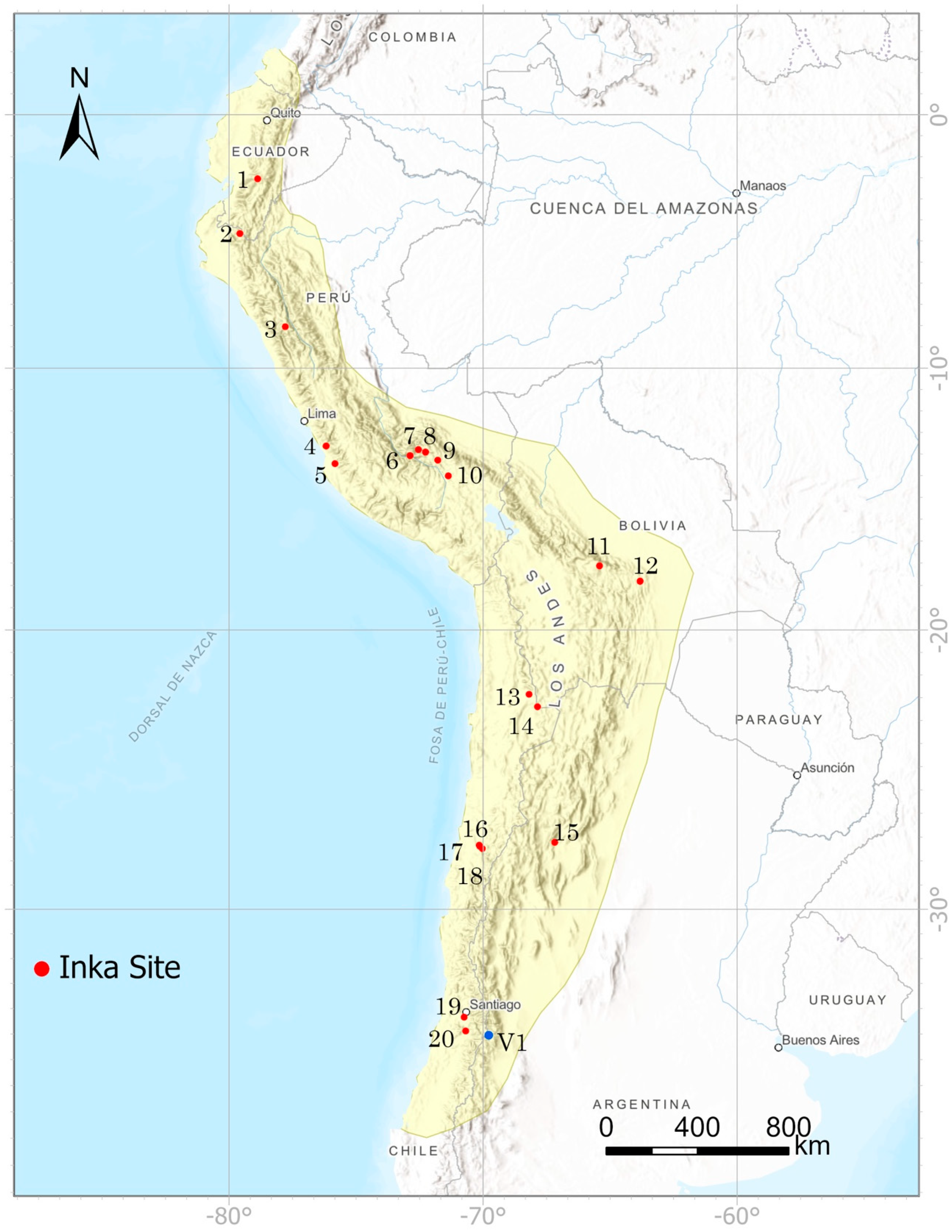
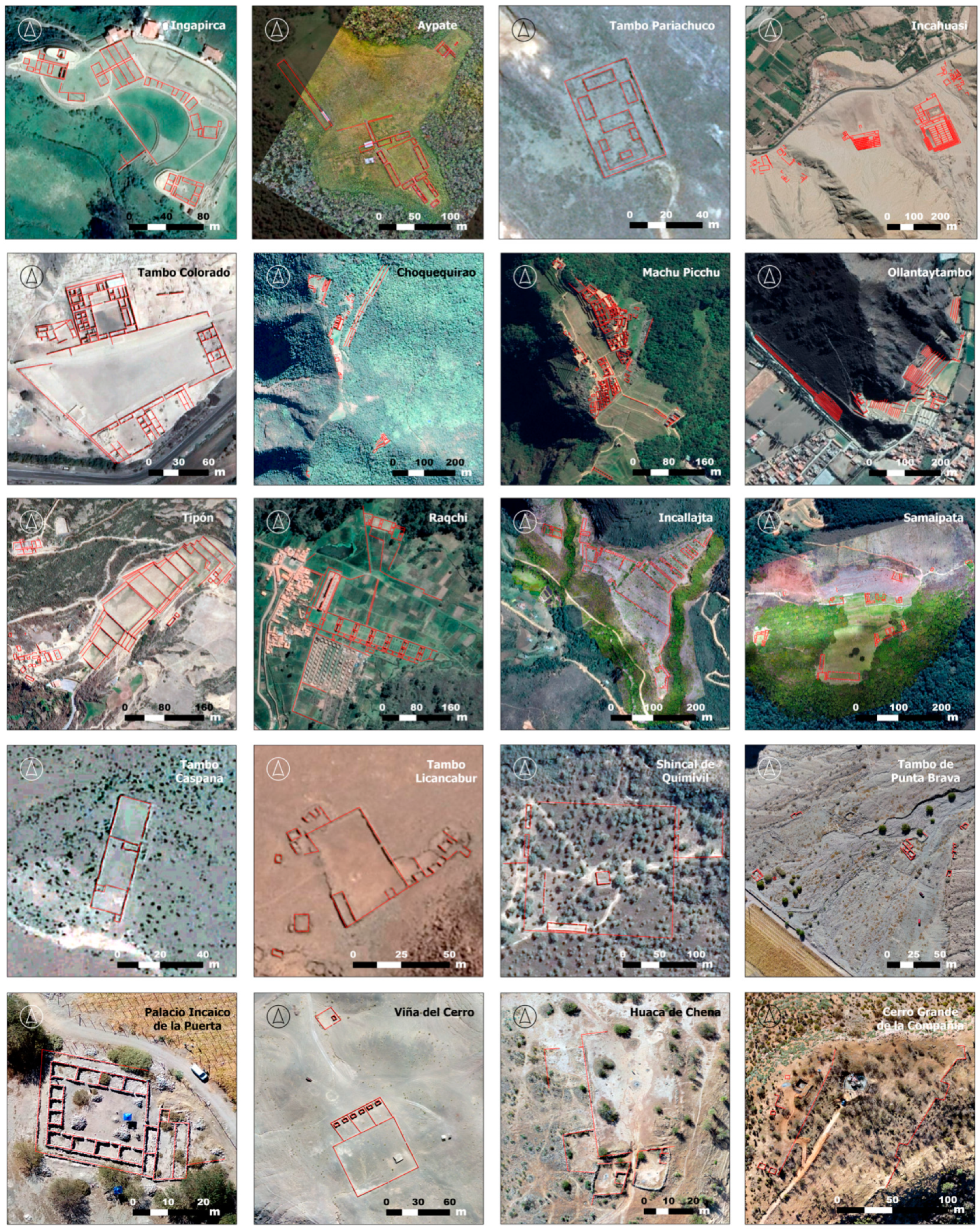
2.1. Inka Site Selection
- Geographic Distribution across Tawantinsuyu: We sought to include sites from across the vast expanse of the Inka empire, spread over various South American countries.
- Reported Site Function: Sites were chosen to represent all types of Inka constructions—religious, residential, administrative, and agricultural. This diversity allows for a multifaceted view of Inka society and its various functional spaces.
- Evidence from Prior Archaeological Studies: We selected sites with confirmed Inka origins, based on previous archaeological research. This criterion lends historical accuracy and validation to the selected Inka architecture.
- State of Preservation: The preservation state of each site was considered, preferring sites with well-preserved features as they provide more reliable data and insights into original Inka architecture.
- Availability of Photogrammetric Survey Data or High-Quality Orthorectified Satellite Imagery: The presence of detailed survey data or clear satellite images is crucial for accurate remote assessments of the sites and a detailed analysis of their walls. Good orthorectification ensures correctly aligned images representing the true surface geometry, which is necessary for correct measurements and analyses.
- Absence of Obstructive Vegetation: Sites with less vegetation cover offer unobstructed views, which are crucial for the architectural study.
2.2. Inka Architecture Analysis
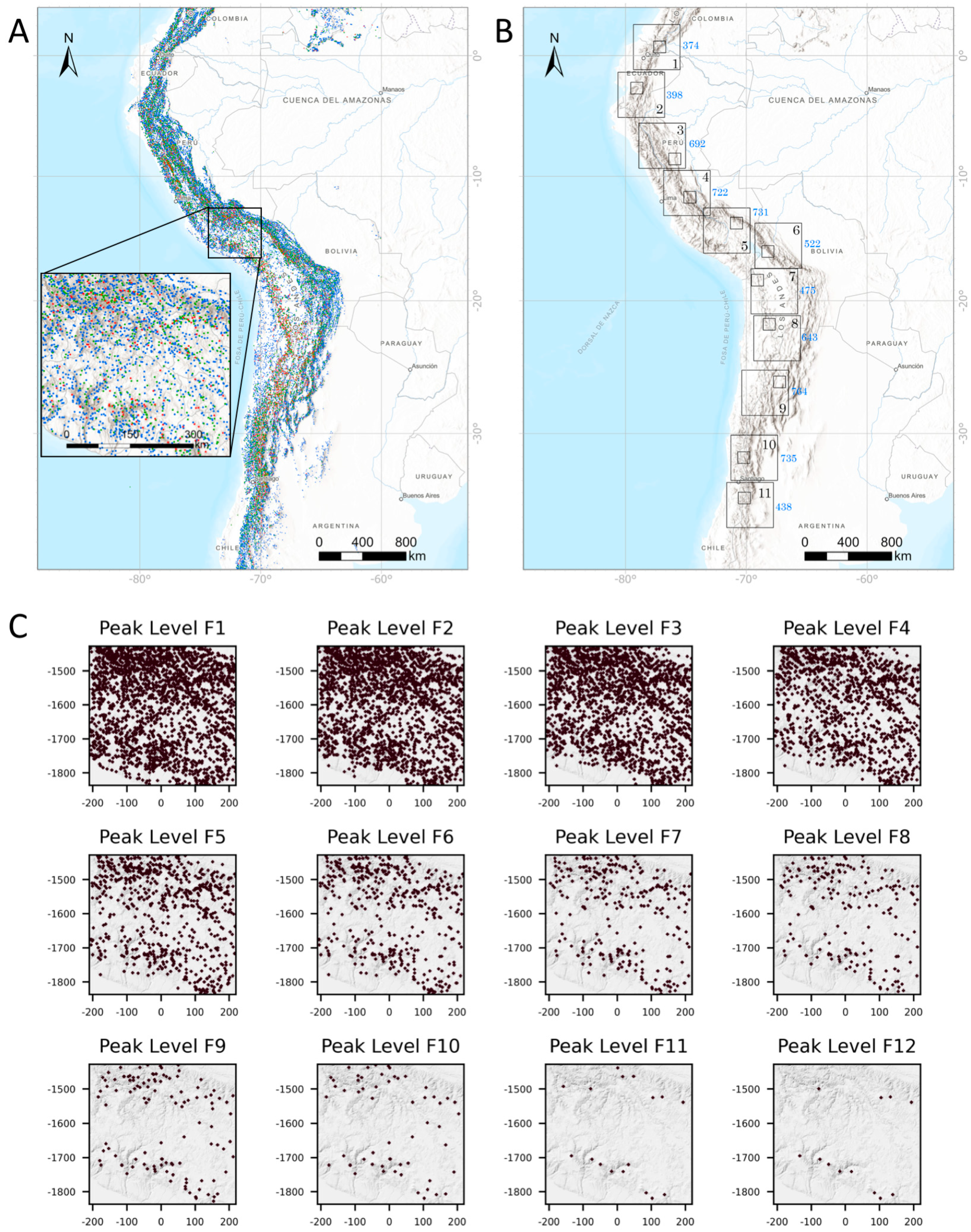
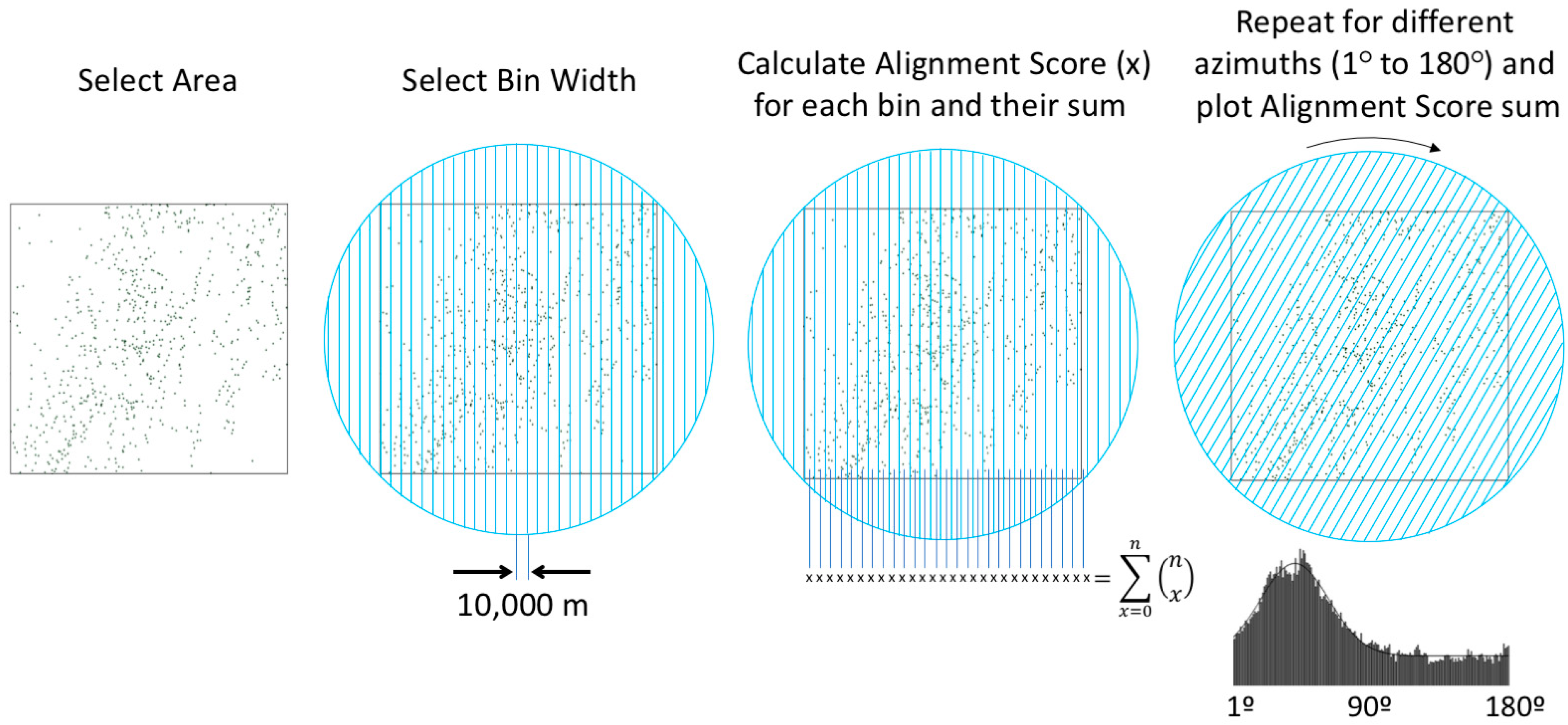
2.3. Mountain-Peak Detection and Filtering
2.4. Mountain-Peak Alignments
2.5. Statistical Analysis
3. Results
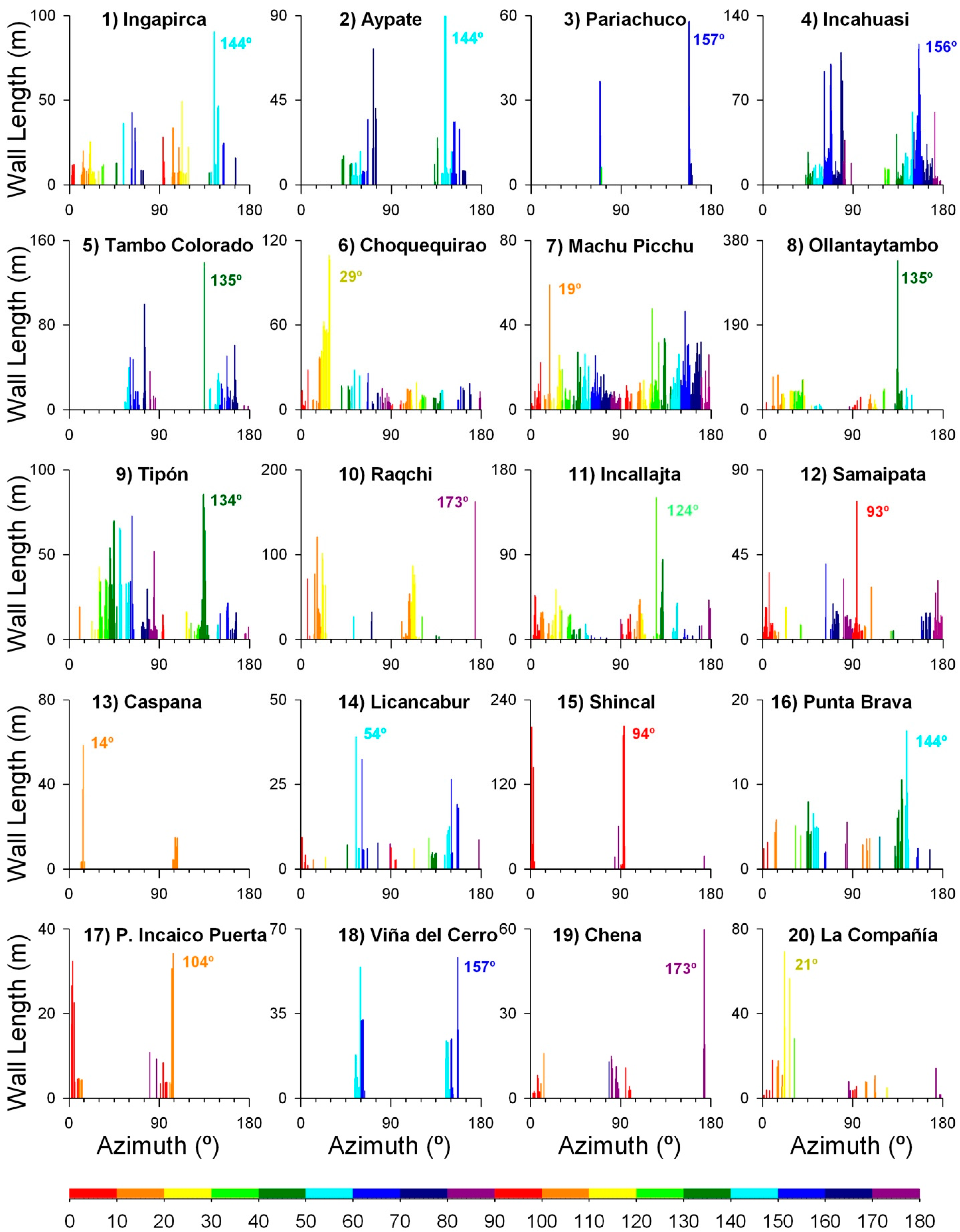
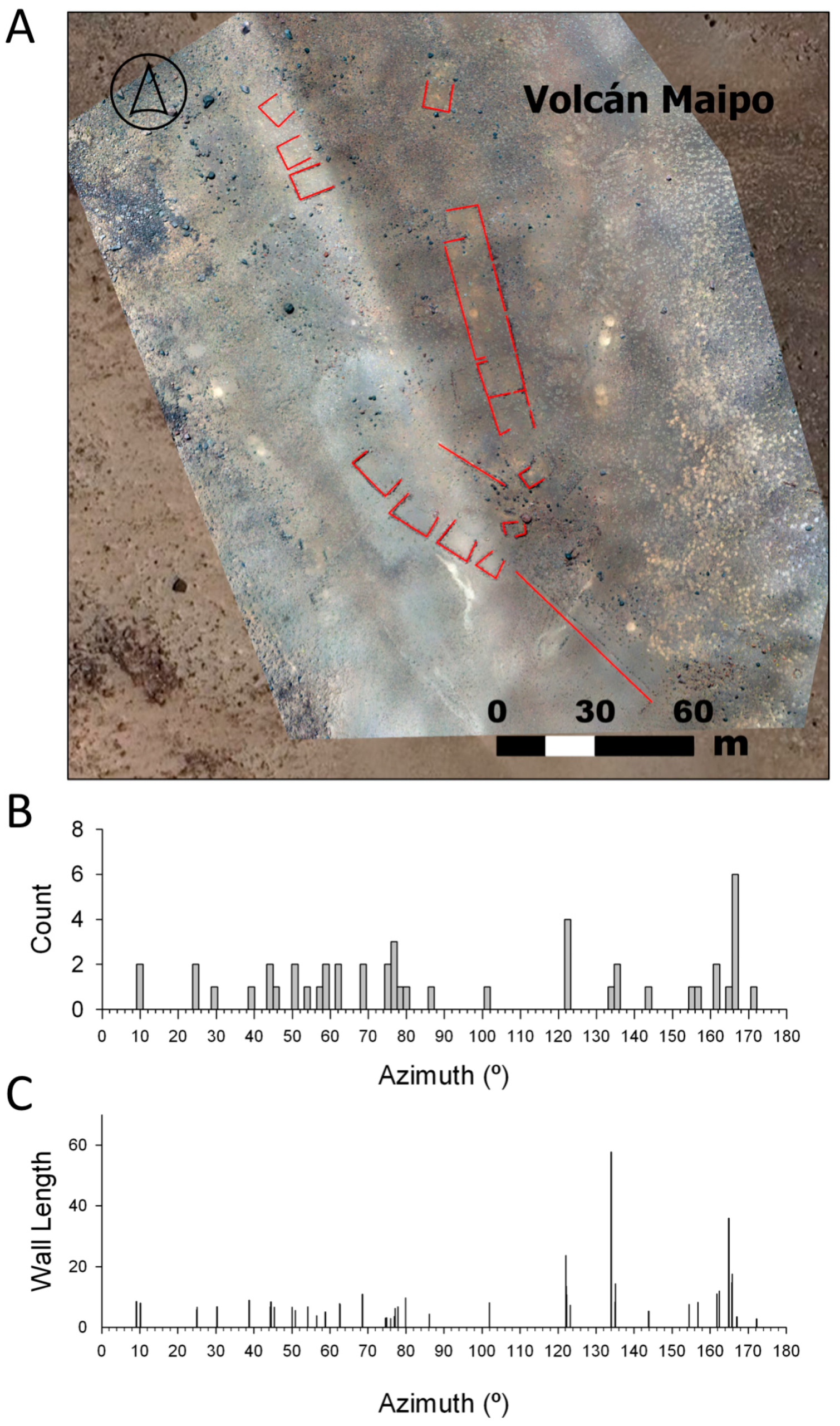
3.1. Inka Site Selection and Wall-Orientation Analysis
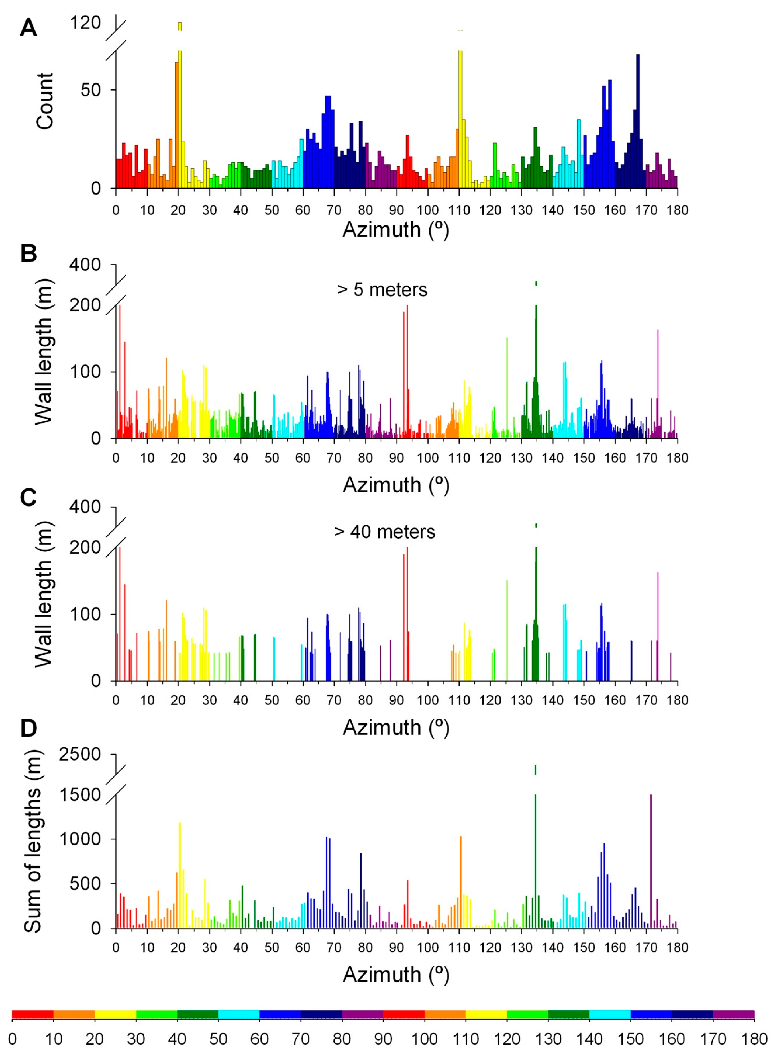
3.2. Inka Wall Database Analysis
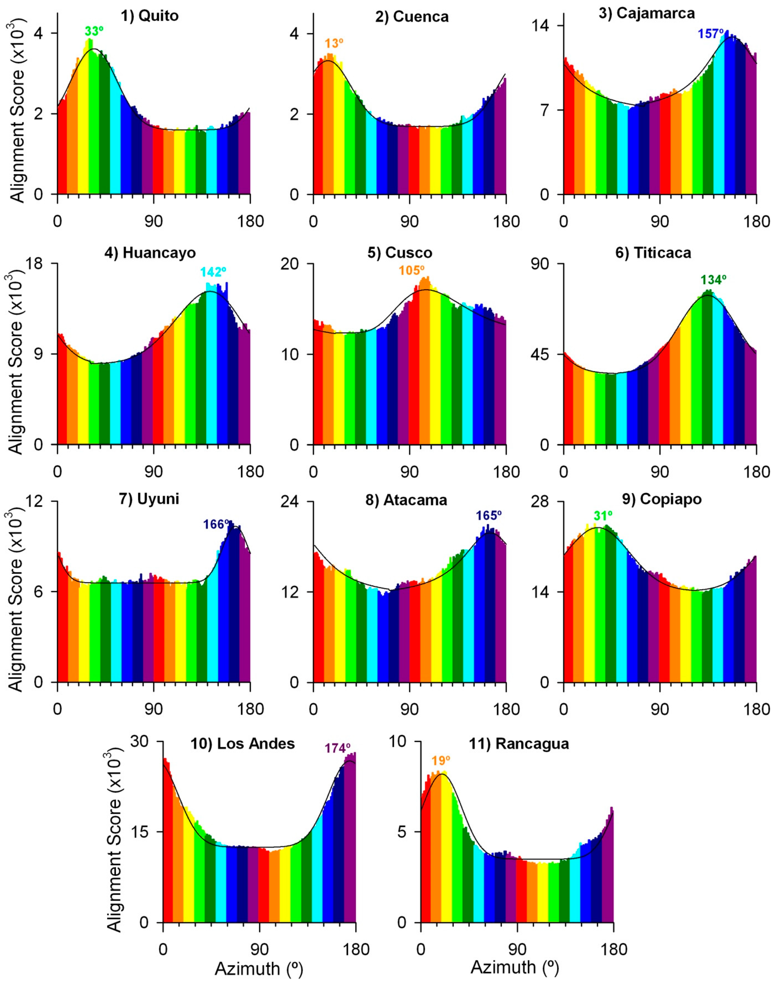
3.3. Geomorphological Analysis of Andes Mountain Range
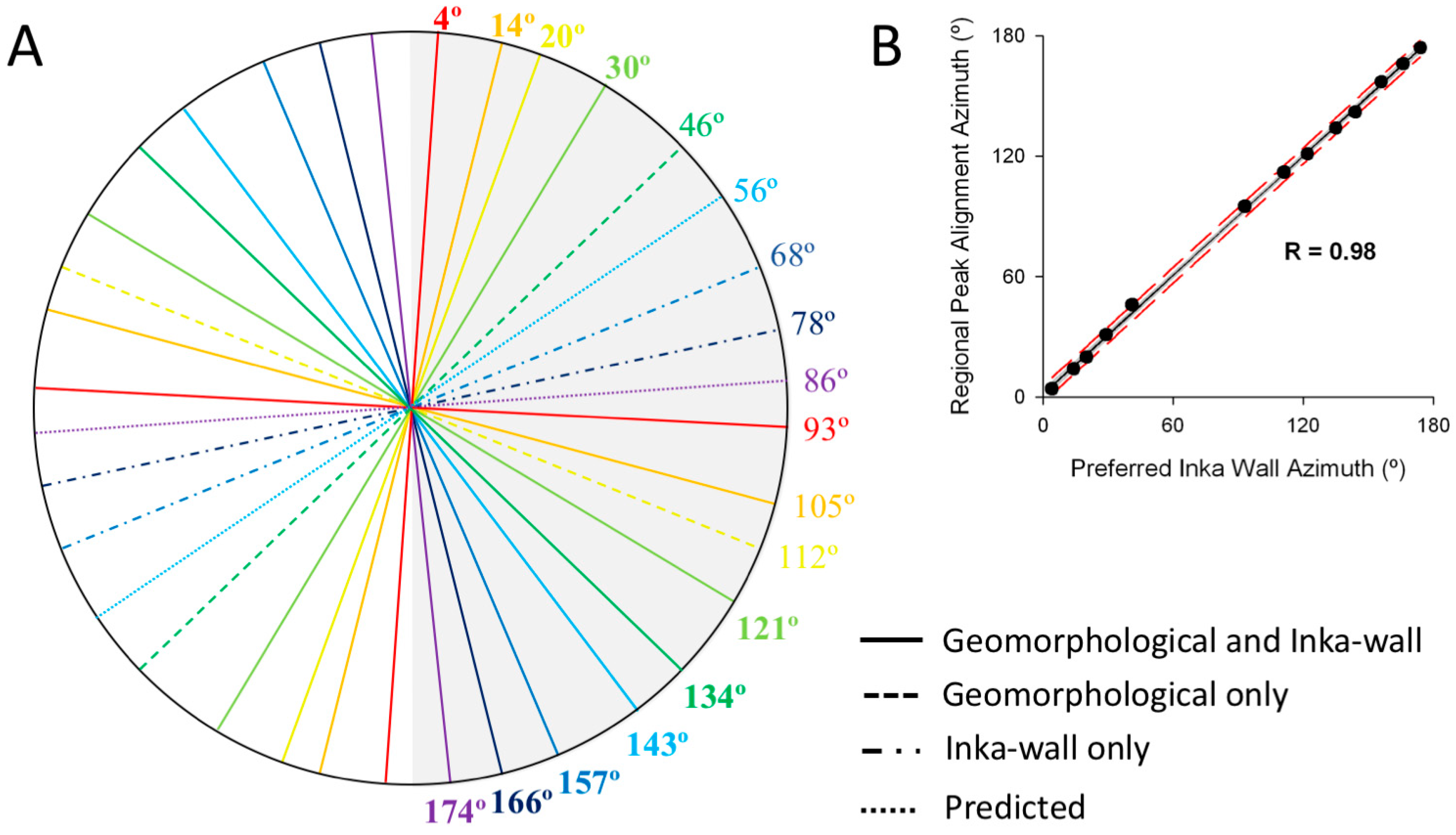
3.4. Correlation Analysis between Inka Wall Orientations and Mountain-Peak Alignments
3.5. Employing Azimuth Analysis to Determine Potential Inka Heritage
4. Discussion
5. Conclusions
Supplementary Materials
Author Contributions
Funding
Data Availability Statement
Acknowledgments
Conflicts of Interest
Appendix A
References
- Gasparini, G.; Margolies, L. Inca Architecture; Indiana University Press: Bloomington, IN, USA, 1980. [Google Scholar]
- Hyslop, J. Inka Settlement Planning; University of Texas Press: Austin, TX, USA, 1990. [Google Scholar]
- Reinhard, J.; Ceruti, C. Sacred Mountains, Ceremonial Sites, and Human Sacrifice Among the Incas. Archaeoastronomy 2005, XIX, 1–43. [Google Scholar]
- Pinasco Carella, A. Pachacámac. Templos, Montañas, Astros y Agua; Universidad Ricardo Palma: Santiago de Surco, Peru, 2019. [Google Scholar]
- Moore, J. Architecture & Power in the Ancient Andes. The Archeology of Public Buildings; Cambridge University Press: Cambridge, UK, 1996. [Google Scholar]
- Gullberg, S.R. The Cosmology of Inca Huacas. Ph.D. Thesis, James Cook University, Townsville, Australia, 2009. [Google Scholar]
- Gonzalez Godoy, C. Comentarios Arqueológicos Sobre La Problemática Inca En Chile Central: Primera Parte. Bol. Soc. Chil. Arqueol. 2000, 29, 39–50. [Google Scholar]
- Zuidema, R.T. The Ceque System of Cuzco: The Social Organization of the Capital of the Inca. Int. Arch. Etnography 1964, 265, 780–785. [Google Scholar]
- Bauer, B.S. The Sacred Lansdcape of the Inca: The Cuzco Ceque System; University of Texas Press: Austin, TX, USA, 1998. [Google Scholar]
- Sepúlveda, S.; Giambiagi, L.B.; Moreiras, S.M.; Pinto, L.; Tunik, M.; Hoke, G.D.; Farías, M. Geodynamic Processes in the Andes of Central Chile and Argentina: An Introduction. Geol. Soc. Lond. 2015, 399, 1–12. [Google Scholar] [CrossRef]
- Turcotte, D.L. Fractals in Geology and Geophysics. Pure Appl. Geophys. 1989, 131, 171–196. [Google Scholar] [CrossRef]
- Robbins, S.J. The Fractal Nature of Planetary Landforms and Implications to Geologic Mapping. Earth Sp. Sci. 2018, 5, 211–220. [Google Scholar] [CrossRef] [PubMed]
- Brown, C.T.; Witschey, W.R.T. The Fractal Geometry of Ancient Maya Settlement. J. Archaeol. Sci. 2003, 30, 1619–1632. [Google Scholar] [CrossRef]
- Sardar, D.; Kulkarni, S.Y. Role of Fractal Geometry in Indian Hindu Temple Architecture. Int. J. Eng. Res. Technol. 2015, 4, 532–537. [Google Scholar]
- Vartholomaios, A. A Geospatial Analysis of the Influence of Landscape and Climate on the Location of Greek Vernacular Settlements Using GIS. Appl. Geomat. 2019, 11, 197–213. [Google Scholar] [CrossRef]
- Aucelli, P.P.C.; Valente, E.; Di Paola, G.; Amato, V.; Cesarano, M.; Cozzolino, M.; Pappone, G.; Scorpio, V.; Rosskopf, C.M. The Influence of the Geological–Geomorphological Setting on Human Settlements and Historical Urban Development: The Case Study of Isernia (Southern Italy). J. Maps 2021, 17, 141–150. [Google Scholar] [CrossRef]
- Rodríguez-Antón, A.; Belmonte, J.A.; González-García, A.C. Romans in the near East: The Orientation of Roman Settlements in Present-Day Jordan. Mediterr. Archaeol. Archaeom. 2016, 16, 153–160. [Google Scholar] [CrossRef]
- Dean, C.J. A Culture of Stone. Inka Perspectives on Rock; Duke University Press: Durham, NC, USA, 2010; ISBN 978-0-8223-4807-8. [Google Scholar]
- Garrido, F.; Plaza, M.T. Provincial Inca Metallurgy in Northern Chile: New Data for the Viña Del Cerro Smelting Site. J. Archaeol. Sci. Rep. 2020, 33, 102556. [Google Scholar] [CrossRef]
- Guédron, S.; Tolu, J.; Delaere, C.; Sabatier, P.; Barre, J.; Heredia, C.; Brisset, E.; Campillo, S.; Bindler, R.; Fritz, S.C.; et al. Reconstructing Two Millennia of Copper and Silver Metallurgy in the Lake Titicaca Region (Bolivia/Peru) Using Trace Metals and Lead Isotopic Composition. Anthropocene 2021, 34, 100288. [Google Scholar] [CrossRef]
- Vitry, C. Caminos Rituales y Montañas Sagradas. Estudio de La Vialidad Inka En El Nevado de Chañi, Argentina. Boletín Del Mus. Chil. Arte Precolomb. 2007, 12, 69–84. [Google Scholar]
- Cruz, P.; Crubézy, E.; Gérard, P. Los Adoratorios de Altura Inkaicos. Una Mirada Desde El Cerro Cuzco, Departamento de Potosí, Bolivia. Mem. Am. 2013, 21, 93–120. [Google Scholar]
- Palacios-Prado, N.; Corominas Sustach, F. Geomorfología Fractal de Los Andes y Su Relación Con El Trazado Urbano y Diseño Arquitectónico de La Cultura Inca. In Proceedings of the 87th Annual Meeting for the Society for American Archaeology, Chicago, IL, USA, 30 March 2022; p. 224. [Google Scholar]
- Verdugo, D. Codigoandino/Encoded-Landscapes: Peak Alignment Release (v0.1.0). Zenodo 2024. [Google Scholar] [CrossRef]
- Engel, F. Early Sites in the Pisco Valley of Peru: Tambo Colorado. Am. Antiq. 1957, 23, 34–45. [Google Scholar] [CrossRef]
- Le Paige, G. El Santuario Incaico Del Licancabur. An. Arqueol. Etnol. 1966, 21, 49–50. [Google Scholar]
- Leonor Adán, A.; Mauricio Uribe, R. El Dominio Inca En La Localidad de Caspana: Un Acercamiento al Pensamiento Político Andino (Río Loa, Norte de Chile). Estudios Atacameños 2005, 29, 41–66. [Google Scholar]
- Alcina Franch, J. Ingapirca: Arquitectura y Áreas de Asentamiento. Rev. Española Antropol. Am. 1978, 127–146. Available online: https://revistas.ucm.es/index.php/REAA/article/view/REAA7878110127A/25357 (accessed on 3 April 2023).
- Planella, M.T.; Stehberg, R.; Tagle, B.; Niemeyer, H.; Del Rio, C. La Fortaleza Indígena Del Cerro Grande de La Compañía y Su Relación Con El Proceso Expansivo Meridional Incaico. In Proceedings of the Actas del XII Congreso Nacional de Arqueología Chilena; Sociedad Chilena de Arqueologías: Temuco, Chile, 1991; pp. 403–421. [Google Scholar]
- Sillar, B. Caminando a Traves Del Tiempo: Geografias Sagradas En Cacha/Raqchi, Departamento Del Cuzco (Peru). Rev. Andin. 2002, 35, 221–246. [Google Scholar]
- Astuhuamán Gonzáles, C.W. Pariacaca: Un Oráculo Imperial Andino. In Volume 2 of Ensayos en Ciencias Sociales; Joffré, G.R., Ed.; Fondo Editorial de la Facultad de Ciencias Sociales, Universidad Nacional Mayor de San Marcos: Lima, Peru, 2004; pp. 15–54. ISBN 9972981274. [Google Scholar]
- Coben, L.S. Incallajta, Performance Center of the Inkas: A Digital Reconstruction and Virtual Reality Analysis. BAR Int. Ser. 2006, 1568, 401–405. [Google Scholar]
- Raffino, R.A.; Moralejo, R.A.; Gobbo, J.D. El Dominio Inka En La Sierra de Zapata (NOA). Investig. Ens. 2007, 309–332. [Google Scholar]
- Echevarría López, G.T.; Valencia García, Z. Choquequirao, Un Asentamiento Imperial Cusqueño Del Siglo XV En La Amazonía Andina. Rev. Haucaypata Investig. Arqueol. Tahuantinsuyo 2011, 1, 32–43. [Google Scholar]
- Bray, T.L. Water, Ritual, and Power in the Inca Empire. Lat. Am. Antiq. 2013, 24, 164–190. [Google Scholar] [CrossRef]
- Giovannetti, M.; Cochero, G.; Spina, J.; Corrado, G.; Valderrama, M.; Aljanati, L.; Ferraris, E. El Shincal de Quimivil, La Capital Ceremonial Inka Del Noroeste Argentino; Quire-Quire: La Plata, Argentina, 2013. [Google Scholar]
- Meyers, A. El Fuerte de Samaipata. Estudios Arqueológicos; Biblioteca del Museo de Historia/UAGRM: Santa Cruz de la Sierra, Bolivia, 2015. [Google Scholar]
- Chu, A. La Plaza y El Ushnu Mayor de Incahuasi, Cañete. Cuad. Del Qhapaq Ñan. Año 3 Nº3 2015, 92–110. Available online: https://qhapaqnan.cultura.pe/sites/default/files/mi/archivo/05%20La%20plaza%20y%20el%20ushnu%20mayor%20de%20Incahuasi-Ca%C3%B1ete-Alejandro%20Chu.pdf (accessed on 3 April 2023).
- Stehberg, R.; Sotomayor, G.; Gatica, C. El Paisaje Ritualizado Del Pukara de Chena. In Proceedings of the Actas del XIX Congreso Nacional de Arqueología Chilena; Sociedad Chilena de Arqueología: Arica, Chile, 2012; pp. 141–147. [Google Scholar]
- Bastante Abuhadba, J.M. Investigaciones Interdisciplinarias En La Llaqta de Machupicchu. Arqueol. Soc. 2016, 32, 267–276. [Google Scholar] [CrossRef]
- Morán-Jorquera, J. Aproximaciones Al Proceso de Patrimonialización Del Territorio: Caso Del Sitio Arqueológico Aypate (2012–2016). Espiral Rev. Geogr. Cienc. Soc. 2020, 2, 107–118. [Google Scholar] [CrossRef]
- García Bengoechea, P. Patrimonio Arqueológico, Puesta En Valor y Restauración En Ollantaytambo. Anthropologica 2022, 40, 255–285. [Google Scholar] [CrossRef]
- Podobnikar, T. Detecting Mountain Peaks and Delineating Their Shapes Using Digital Elevation Models, Remote Sensing and Geographic Information Systems Using Autometric Methodological Procedures. Remote Sens. 2012, 4, 784–809. [Google Scholar] [CrossRef]
- Ritter, J. An Efficient Bounding Sphere. In Graphics Gems; Glassner, A.S., Ed.; Academic Press Professional, Inc.: San Diego, CA, USA, 1990; Volume 1, pp. 301–303. ISBN 0-12-286166-3. [Google Scholar]
- Kruhl, J.H. Fractal-Geometry Techniques in the Quantification of Complex Rock Structures: A Special View on Scaling Regimes, Inhomogeneity and Anisotropy. J. Struct. Geol. 2013, 46, 2–21. [Google Scholar] [CrossRef]
- Corrado, G.; Giménez Benítez, S. The Orientation of the Ushnu of “El Shincal Del Quimivil” (Catamarca, Argentina). Comechingonia. Rev. Arqueol. 2019, 22, 251–263. [Google Scholar] [CrossRef]
- Nielsen, A.E.; Berenguer, J.; Sanhueza, C. El Qhapaqñan Entre Atacama y Lípez. Intersecc. Antropol. 2006, 7, 217–234. [Google Scholar]
- Planella, M.T.; Stehberg, R. Etnohistoria y Arqueologia En El Estudio de La Fortaleza Indigena de Cerro Grande de La Compañia. Chungara 1994, 26, 65–78. [Google Scholar]


| Site # | Name | Number of Walls | Min. Length (m) | Max. Length (m) | Sum of Lengths (m) | Pref. Azimuth (°) | Longest Wall Azimuth (°) |
|---|---|---|---|---|---|---|---|
| 1 | Ingapirca | 110 | 2.8 | 90.4 | 1486 | 12; 102; 112 | 144 |
| 2 | Aypate | 95 | 1.5 | 115 | 1285 | 59; 144 | 144 |
| 3 | Pariachuco | 32 | 3.3 | 58 | 468 | 69; 158 | 157 |
| 4 | Incahuasi | 523 | 1.4 | 116 | 8386 | 69; 157; 166 | 156 |
| 5 | Tambo Colorado | 140 | 2.8 | 139 | 2230 | 75; 166 | 135 |
| 6 | Choquequirao | 147 | 2.4 | 109.6 | 2281 | 20; 108 | 29 |
| 7 | Machu Pichu | 592 | 1.7 | 71 | 3871 | 65; 157 | 19 |
| 8 | Ollantaytambo | 132 | 3.1 | 335 | 4691 | 19; 135 | 135 |
| 9 | Tipón | 210 | 1.9 | 89.6 | 3644 | 41; 135;166 | 134 |
| 10 | Raqchi | 346 | 1.2 | 162 | 4528 | 20;111 | 173 |
| 11 | Incallajta | 136 | 1.5 | 150 | 2470 | 112; 128 | 125 |
| 12 | Samaipata | 193 | 1 | 73 | 1494 | 3; 93 | 93 |
| 13 | Caspana | 15 | 2.7 | 58 | 202 | 14; 105 | 14 |
| 14 | Licancabur | 46 | 2 | 39 | 374 | 132; 149 | 54 |
| 15 | Shinkal | 35 | 4.8 | 202 | 1368 | 3; 93 | 3 |
| 16 | Punta Brava | 49 | 1.4 | 16 | 219 | 14; 144 | 144 |
| 17 | P. Incaico de la P. | 39 | 2.6 | 34 | 408 | 3; 103 | 104 |
| 18 | Viña del Cerro | 54 | 1.4 | 58 | 562 | 60; 145 | 157 |
| 19 | Huaca de Chena | 26 | 1.7 | 60 | 251 | 8; 85 | 173 |
| 20 | La Compañía | 38 | 1.3 | 69 | 450 | 20; 112 | 21 |
| V1 | Volcán Maipo | 48 | 2.7 | 58 | 471 | 122; 166 | 134 |
| Area # | Name | Upper Right x | Upper Right y | Lower Left y | Lower Left y | Min–Max Elev. | # Peaks (F1) | # Peaks (F5) | # Peaks (F8) | Highest Align. Azimuth |
|---|---|---|---|---|---|---|---|---|---|---|
| 1 | Quito | −8403033 | 286740 | −8833084 | −129744 | 743–5862 | 1552 | 374 | 81 | 33° |
| s1 | Quito | −8534724 | 134229 | −8646157 | 26254 | 869–4176 | 179 | 47 | 9 | 46° |
| 2 | Cuenca | −8545303 | −153031 | −8975354 | −569524 | 720–6239 | 1716 | 398 | 77 | 13° |
| s2 | Cuenca | −8745950 | −245057 | −8857382 | −353032 | 981–4471 | 184 | 54 | 10 | 96° |
| 3 | Cajamarca | −8352630 | −622010 | −8782681 | −1038541 | 754–6525 | 2562 | 692 | 133 | 157° |
| s3 | Cajamarca | −8395975 | −897819 | −8507408 | −1005794 | 816–2499 | 147 | 22 | 1 | 158° |
| 4 | Huancayo | −8124806 | −1057264 | −8554857 | −1473856 | 757–5803 | 2470 | 722 | 124 | 142° |
| s4 | Huancayo | −8256265 | −1250819 | −8367698 | −1358794 | 943–5448 | 299 | 105 | 21 | 134° |
| 5 | Cusco | −7757108 | −1403640 | −8187159 | −1820305 | 792–6407 | 2297 | 731 | 173 | 105° |
| s5 | Cusco | −7827370 | −1489011 | −7938803 | −1596986 | 998–6275 | 195 | 89 | 17 | 121° |
| 6 | Titicaca | −7282930 | −1542982 | −7712981 | −1959688 | 794–6325 | 1895 | 522 | 93 | 134° |
| s6 | Titicaca | −7537615 | −1750833 | −7649047 | −1858808 | 1237–6275 | 235 | 97 | 24 | 136° |
| 7 | Uyuni | −7319541 | −1962979 | −7749592 | −2379788 | 1035–6524 | 1397 | 475 | 127 | 166° |
| s7 | Uyuni | −7634115 | −2014900 | −7745548 | −2122875 | 3274–6524 | 125 | 61 | 19 | 29° |
| 8 | Atacama | −6983905 | −2384989 | −7413956 | −2801892 | 1121–6184 | 1504 | 643 | 218 | 165° |
| s8 | Atacama | −7525474 | −2421368 | −7636906 | −2529343 | 3201–6082 | 142 | 100 | 36 | 136° |
| 9 | Copiapo | −7403977 | −2898592 | −7834028 | −3315652 | 894–6870 | 1924 | 764 | 222 | 31° |
| s9 | Copiapo | −7430858 | −2952249 | −7542290 | −3060224 | 3244–5964 | 113 | 48 | 14 | 14° |
| 10 | Los Andes | −7504407 | −3496853 | −7934458 | −3914109 | 676–6880 | 1978 | 735 | 168 | 174° |
| s10 | Los Andes | −7759889 | −3649963 | −7871321 | −3757938 | 1771–6635 | 260 | 114 | 35 | 165° |
| 11 | Rancagua | −7542634 | −3933173 | −7972685 | −4350576 | 613–6049 | 1499 | 438 | 108 | 19° |
| s11 | Rancagua | −7754822 | −4022352 | −7866255 | −4130327 | 1001–5228 | 258 | 94 | 28 | 14° |
Disclaimer/Publisher’s Note: The statements, opinions and data contained in all publications are solely those of the individual author(s) and contributor(s) and not of MDPI and/or the editor(s). MDPI and/or the editor(s) disclaim responsibility for any injury to people or property resulting from any ideas, methods, instructions or products referred to in the content. |
© 2024 by the authors. Licensee MDPI, Basel, Switzerland. This article is an open access article distributed under the terms and conditions of the Creative Commons Attribution (CC BY) license (https://creativecommons.org/licenses/by/4.0/).
Share and Cite
Palacios-Prado, N.; Corominas-Sustach, F.; Pérez, A.; Verdugo, D.; Podobnikar, T. Encoded Landscapes: A Link between Inka Wall Orientations and Andean Geomorphology. Land 2024, 13, 463. https://doi.org/10.3390/land13040463
Palacios-Prado N, Corominas-Sustach F, Pérez A, Verdugo D, Podobnikar T. Encoded Landscapes: A Link between Inka Wall Orientations and Andean Geomorphology. Land. 2024; 13(4):463. https://doi.org/10.3390/land13040463
Chicago/Turabian StylePalacios-Prado, Nicolás, Fabiola Corominas-Sustach, Andrés Pérez, Danilo Verdugo, and Tomaž Podobnikar. 2024. "Encoded Landscapes: A Link between Inka Wall Orientations and Andean Geomorphology" Land 13, no. 4: 463. https://doi.org/10.3390/land13040463
APA StylePalacios-Prado, N., Corominas-Sustach, F., Pérez, A., Verdugo, D., & Podobnikar, T. (2024). Encoded Landscapes: A Link between Inka Wall Orientations and Andean Geomorphology. Land, 13(4), 463. https://doi.org/10.3390/land13040463