Article

Identifying Potential National Park Locations Based on Landscape Aesthetic Quality in the Hengduan Mountains, China

1
State Key Laboratory of Ecological Safety and Sustainable Development in Arid Lands, Xinjiang Institute of Ecology and Geography, Chinese Academy of Sciences, Urumqi 830011, China
2
University of Chinese Academy of Sciences, Beijing 100049, China
*
Author to whom correspondence should be addressed.
Land 2024, 13(8), 1278; https://doi.org/10.3390/land13081278
Submission received: 6 July 2024 / Revised: 6 August 2024 / Accepted: 10 August 2024 / Published: 13 August 2024

Abstract

:
Landscape aesthetic quality (LAQ) evaluation is vital in territorial spatial planning. It helps to achieve the rational development and protection of territorial space and ensures the harmonious coexistence of developments and the ecological environment. Based on mapping and quantification, this paper took LAQ evaluation as the object, established a methodological framework for large-scale natural LAQ evaluation, excavated and identified key areas with outstanding landscape aesthetics service supply capabilities, and supported regional landscape planning and protection management. This paper took the Hengduan Mountains in China as an example to evaluate and identify the spatial distribution of the LAQ in mountainous areas. The results showed that the high-value LAQ areas are located east and south of the Hengduan Mountains, where high-quality natural landscapes are concentrated and have significant potential for establishing national parks. The evaluation results of the LAQ can provide a good reference for the spatial identification of future national parks in the Hengduan Mountains. Moreover, our research can provide a scientific basis for large-scale landscape spatial planning and decision-making for the classified protection and rational utilization of landscape resources and other mountain ecosystems.

1. Introduction

Landscape aesthetic services are defined as essential ecosystem services that positively impact human health and well-being [1]. Landscape aesthetic quality (LAQ) evaluation can identify and define areas with important aesthetic value, providing decision support for these areas’ protection and rational utilization [2]. Globally, LAQ evaluation, as a policy tool, has attracted increasing attention from academia and decision-making management departments. Hermes et al. (2018) developed a method for a spatially explicit national assessment of the LAQ that adopted landscape diversity, naturalness, and uniqueness as established indicators of landscape attractiveness and spatially evaluated and mapped each of them [3]. The results demonstrated that the LAQ varies substantially across Germany. Areas of high LAQ were located in the German mountain ranges, riverine landscapes, coast, and islands, whereas particularly low LAQ scores were found in urban agglomerations and intensively used open agrarian landscapes. Kalinauskas et al. (2021) adapted Geographic Information Systems modeling and spatial statistics analysis to map and assess the LAQ in Lithuania on the national scale [4]. The results revealed that agricultural and urban areas had the lowest LAQ, while areas with high ruggedness, forests, protected areas, natural monuments, and heritage sites had the highest LAQ scores. Mapping and assessing the LAQ at the large regional level can provide valuable insights to policymakers about the general condition of ecosystem services.
Although significant progress has been made in mapping and quantifying the LAQ, mapping and evaluating it is still challenging because it has focused on common aesthetic needs; was based on key elements that are objective, operable, and targeted; and is reliably applicable in a wider geographical area [5]. Landscape diversity was the most frequently used item in various LAQ evaluation systems, which was recognized as one of the most critical determinants and was widely applied in landscape aesthetics service supply evaluation. In the USDA Forest Management system’s earliest LAQ evaluation, the types and diversity of landscape elements such as the vegetation, form, and color were most relevant [6]. Several authors defined naturalness and landscape diversity as assessment criteria and selected Shannon’s Diversity Index (SHDI), the Shape Index (SHAPE), and Patch Density (PD) as indicators to form an objective, landscape metrics-based assessment approach [3,7]. Landscape naturalness or authenticity was also highly selected in the LAQ evaluation. Many studies found that naturalness was key in describing landscape aesthetic characteristics. Seasonality was often overlooked, even though it was a typical quality of landscapes in temperate regions, and Schüpbach et al. (2016) incorporated aesthetic evaluation and seasonality into a diversity index as a proxy for quality [8]. In addition, land use/land cover change was also an essential factor affecting the aesthetic value of mountain landscapes and was very important for decision-making and landscape planning [9]. Schirpke et al. (2021) created a regression model based on GIS and found that the areas above the tree line in the Central Alps had the highest scenic beauty [10]. Many studies showed that species richness, functional richness, and landscape heterogeneity significantly affected the aesthetic value [2]. People generally connected their aesthetic perception of landscapes with their ecological quality. Since aesthetic experience induces a social motivation for ecological protection, the results of evaluating the LAQ are significant to the biodiversity conservation action plan.
The core purpose of LAQ evaluation and mapping is to spatially assess the supply capacity of landscape aesthetics services and explore land space potential areas with high supply capacity. Therefore, the question to be solved is: What factors affect the quality of landscape aesthetics? What kind of space has high aesthetic quality? We mainly conducted the following research: (1) establish a methodology for evaluating the aesthetic quality of large-scale natural landscapes; (2) take the Hengduan Mountains in China as an example to evaluate the aesthetic quality of large-scale landscapes; and (3) identify the concentrated distribution locations of large-scale natural landscape clusters with outstanding LAQ. This paper established the mapping relationship between the physical characteristics of natural landscape beauty and service functions, providing a decision-making basis for the classification, protection, and rational utilization of mountain ecosystem landscape resources. The findings can provide valuable insights into landscape planning and decision-making to develop management strategies that maintain landscape values.

2. Materials and Methodology
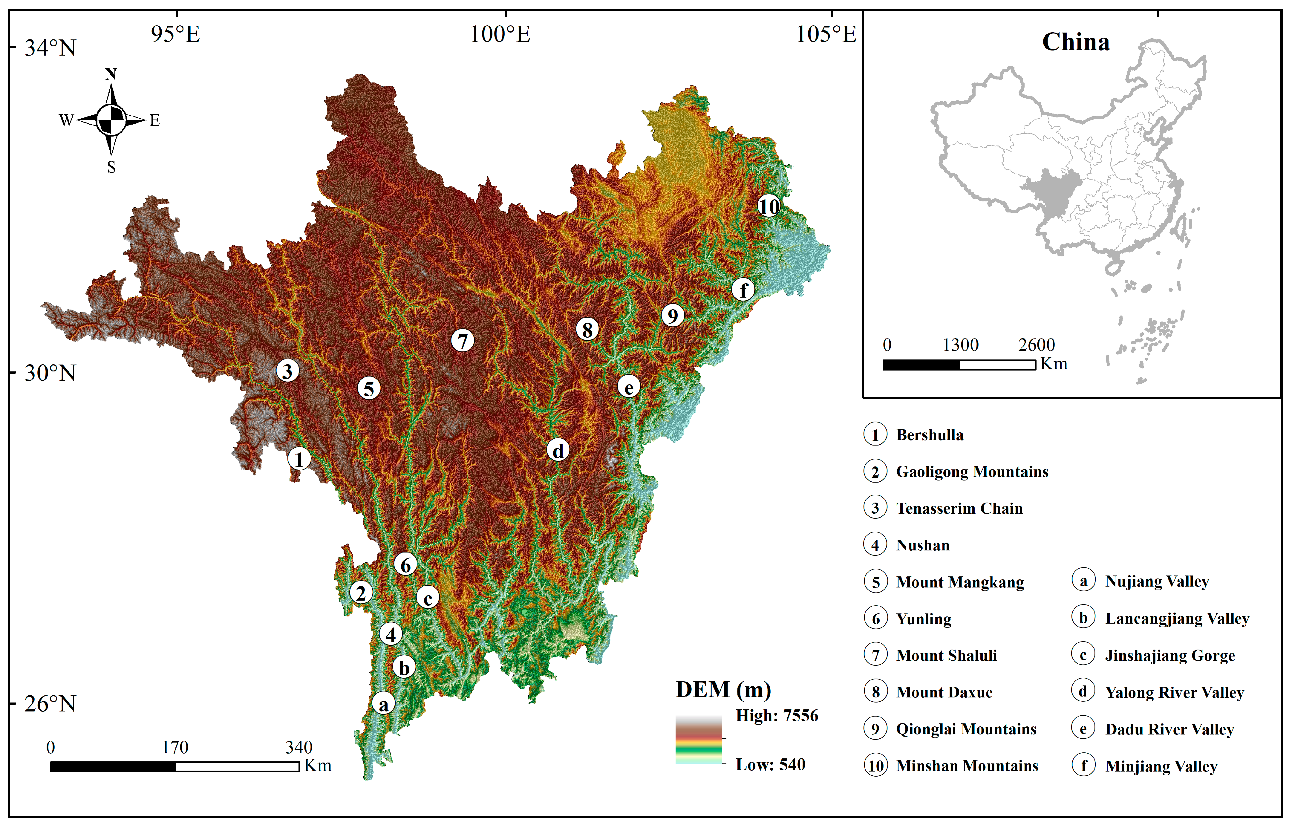
2.1. Study Area

The Hengduan Mountains are located in southwest China (93°35′−104°59′ E, 25°32′−34°19′ N). The administrative areas are about 434,030.8 km2. The climate of the Hengduan Mountains is affected by the high-altitude westerly circulation and the Indian and Pacific monsoon circulations, which have dry winters and rainy summers, and the dry and wet seasons are apparent [11]. The geological characteristics of the Hengduan Mountains are unique, and their formation is closely related to the violent collision and compression between the Eurasian and Indian Ocean plates [12]. Since the Hengduan Mountains span multiple climate zones, the soil types range from tropical to cold zones and contain red, brown, dark brown, and subalpine meadows [13].
Because of the above reasons, the densest river networks, the most complex terrains, and the most concentrated mountain valleys here were formed in China [14]. The strong deep-cutting of the north–south rivers and valleys shaped a series of north–south parallel mountains. From west to east, there are the Bershulla–Gaoligong Mountains, Tenasserim Chain–Nushan, Mount Mangkang–Yunling, Mount Shaluli, Mount Daxue, Qionglai Mountains, and Minshan Mountains, between which are the Nujiang, Lancangjiang, Jinshajiang, Yalong River, Dadu River, Minjiang, and their tributaries (Figure 1). The mountains and rivers from north to south form a typical “parallel ridge valley”, which gathers mountains, valleys, snow peaks, glaciers, forests, meadows, wetlands, lakes, waterfalls, and other rich and diverse natural landscapes [15]. Jiuzhaigou, Huanglong, Giant Panda Habitat, and Three Parallel Rivers exist here (Figure 2). Owing to the global outstanding aesthetic value, they align with the criteria (vii) of the World Heritage List and were included on it. In addition, Chinese National Geography rated Tiger Leaping Gorge in Jinshajiang, Nujiang Grand Canyon, and Meili Grand Canyon in Lancangjiang as China’s most beautiful canyons.

2.2. Data Sources and Preparation

This study used the land cover data from Copernicus Global Land Service, which contains 19 land cover types (Figure 3) with a spatial resolution of 100 m (https://land.copernicus.eu/, accessed on 01 August 2022). The digital elevation model (DEM) was from Geospatial Data Cloud with a spatial resolution of 30 m (http://www.gscloud.cn/, accessed on 1 August 2022). Both were in a grid format, and the year was 2019. Data processing and mapping were based on Fragstats 4.2.1 and ArcGIS 10.2 software, and the projection adopted Asia Lambert Conformal Conic. Except for the relief degree of land surface (RDLS), a 10 km × 10 km grid was used as the evaluation unit for calculating the rest of the landscape indexes. The overlays of each index were uniformly resampled to 100 m × 100 m grids.

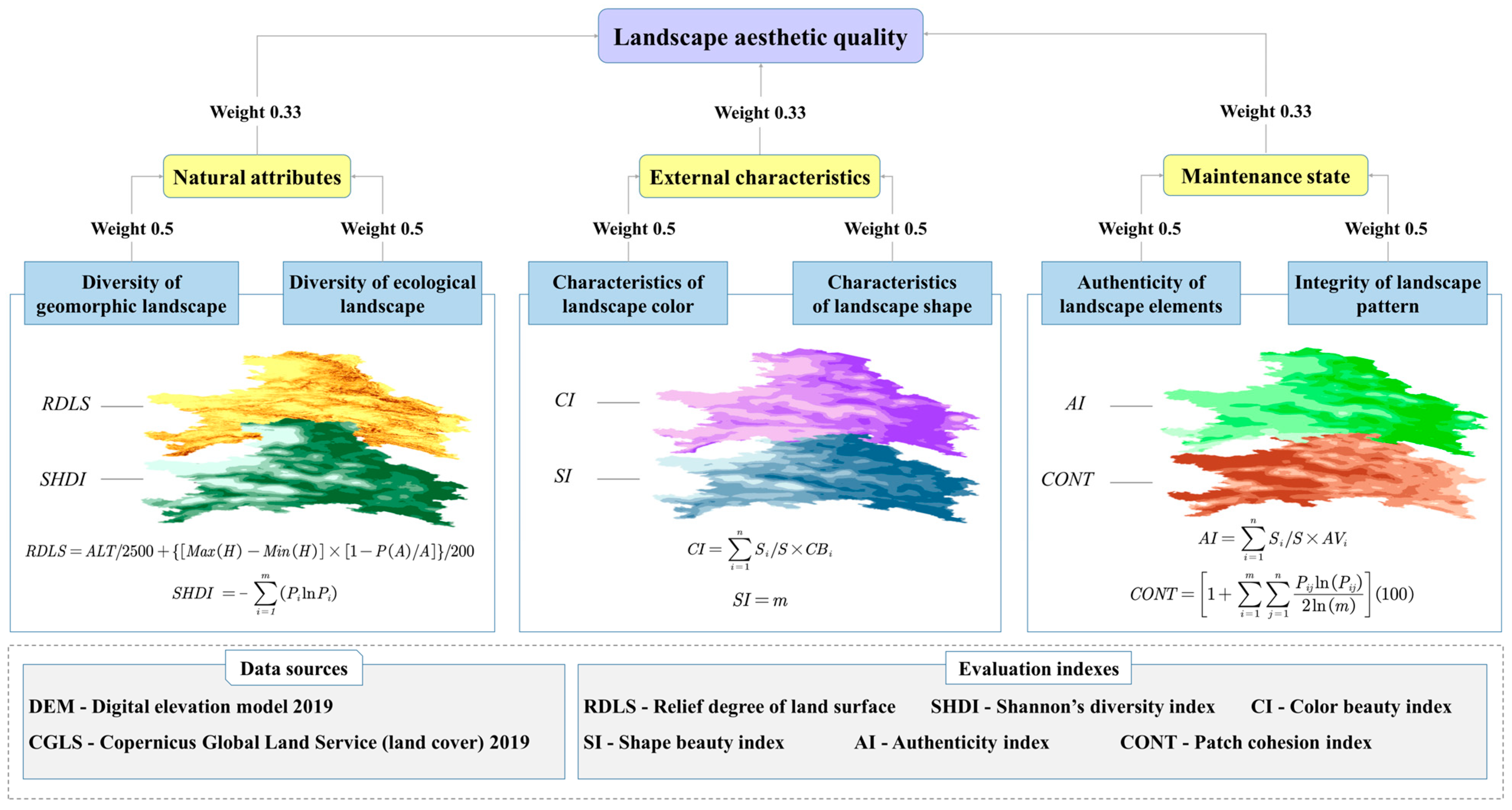
2.3. Methodological Approach to Landscape Aesthetic Quality

This paper constructed the evaluation framework (based on the methodology proposed by Hermes et al. (2018)) of the aesthetic quality of large-scale mountain natural landscapes from natural attributes, external characteristics, and maintenance state. In order to facilitate the overlay of various indicators, we adopted Fuzzy Membership for normalization. To avoid the difference in results caused by the weight size, we assigned weights in equal proportions (the weight of a single indicator is 0.5, and the weight of each aspect is 0.33) and applied the raster calculator. Further, the results were divided into five grades based on the natural breaks (Jenks) method. Figure 4 shows the relation and weight of the indicators in the three aspects.

2.4. Methodology for Assessing the Main Attributes of LAQ Analysis

2.4.1. Natural Attributes of LAQ

The mountains are composed of many hills and valleys, with peaks and valleys interspersed, and the terrain is remarkably rugged. At a mountain region scale, as a whole, the geomorphic diversity correlates with ecological diversity [16,17], which forms a rich landscape pattern manifested as landscape diversity. Therefore, based on the inherent natural properties of the LAQ, this paper uses the RDLS to evaluate the diversity of the large-scale geomorphological landscape of mountains and SHDI to evaluate the diversity of the large-scale ecological landscapes of mountains. The higher the diversity of the landscape, the higher is the LAQ.
(1) Diversity of geomorphic landscape
The RDLS effectively represents the characteristics of mountain profiles and surface relief in specific areas. We referred to the calculation of the RDLS proposed by Feng et al. (2020) [18], building the model according to the average altitude, the relative height difference of the optimal window (rectangular neighborhood of 41 × 41 pixels), and the proportion of flat land. The larger the value is, the more complex and diverse the geomorphic landscape. Formula (1) shows the calculation of the RDLS:
R D L S = A L T / 2500 + { [ M a x ( H ) M i n ( H ) ] × [ 1 P ( A ) / A ] } / 200
where ALT refers to the average elevation of a specific area centered on a grid cell (m); Max (H) and Min (H) refer to the highest and lowest elevations (m); P (A) refers to the flat land area (km2), where the relative height difference under the optimal window is less than 30 m; A refers to the total area of the study area (km2).
(2) Diversity of ecological landscape
SHDI is widely used to measure the diversity of ecological landscapes [7]. Landscape diversity refers to the richness of landscape ecosystem types in specific spatial–temporal ranges and the diversity and complexity of each landscape ecosystem’s different elements in the spatial structure. When there was only one patch type in the landscape, SHDI = 0; when the patch types increased, or their proportions tended to be similar, the value also increased accordingly [19]. This paper merges the cultivated and managed vegetation/agriculture (cropland), urban/build up, snow and ice, and permanent water bodies into a separate type (others). The SHDI values were calculated using different vegetation types to express the diversity of ecological landscapes. Formula (2) shows the calculation of SHDI:
S H D I = i = 1 m   ( P i l n P i )
where m is the number of vegetation types, and Pi is the proportion of area covered by vegetation type i.

2.4.2. External Characteristics of LAQ

Aesthetic features refer to the external beauty of large-scale natural landscapes in terms of color, shape, dynamic, and seasonal equality. Mountains form a rich vertical natural landscape zone due to their elevation differences. There are abundant vegetation landscapes, including evergreen broad-leaved forests, mixed deciduous broad-leaved and evergreen broad-leaved forests, temperate coniferous forests, shrubland grassland, and meadows [20]. Different vegetation landscapes showed different seasonal characteristics with the change in season, and landscape groups showed different morphological characteristics with the change in altitude. The CI and SI were used to evaluate and identify the aesthetic characteristics of the large-scale natural landscape in the mountains.
(1) Characteristics of landscape color
Color beauty is one of the important characteristics of landscape aesthetics [21]. Landscapes with rich colors stand out easier from space and are more highly recognized. Thus, we divided it into five grades from high to low, and the values were assigned as 5, 4, 3, 2, and 1. The higher the value is, the more beautiful the landscape. The color beauty index (CI) is quantified as in Formula (3):
C I = i = 1 n   S i / S × C B i
where n refers to the number of landscape types in the evaluation unit, S refers to the unit’s total area, Si refers to the area of landscape type i in the unit, and CBi refers to the color beauty value corresponding to landscape type i.
The study area of this paper, the Hengduan Mountains, has diverse marine glaciers, where glaciers blend with forests to form magnificent landscapes. In spring and summer, the alpine flowers (such as rhododendrons, which belong to shrubs) compete in beauty; in autumn, the primary forests are colorful, creating rich and multi-layered landscapes. Meanwhile, forest landscape elements present different colors and diverse scenes with seasonal changes in the year. Therefore, the color beauty value of snow mountains, glaciers, deciduous broad-leaved mixed forests, coniferous broad-leaved mixed forests, and shrubs was assigned the highest value. Furthermore, this paper mainly evaluated the aesthetic quality of natural landscapes and emphasized the original, so the artificial landscape value was assigned the lowest value. It should be noted that closed forest refers to tree canopy > 70%, while open forest refers to top layer-trees 15–70% and second layer-mixed shrubs and grassland; since closed forest (unknown) and open forest (unknown) refer to forests that do not match the other definitions, their value is relatively low. We classified landscape types into five levels based on their aesthetic and color change during one season and multiple seasons of the year. Table 1 shows the levels.
(2) Characteristics of landscape shape
Shape beauty is another essential feature of landscape aesthetics. Different vegetation landscapes are interlaced. The stronger the sense of hierarchy and the richer the combination, the higher is the aesthetic value [22]. For this reason, this paper selected spatial patterns of the combination of vegetation-interlaced zones to reflect the beauty of the landscape shape. The non-vegetation landscapes (such as cropland, urban/built up, snow and ice, and permanent water bodies) were merged into one type, while the vegetation landscapes (such as forests, shrubs, herbaceous vegetation, herbaceous wetland, moss and lichen, and bare/sparse vegetation) were separated. The shape beauty index (SI) assesses the number of landscape types in each evaluation unit.

2.4.3. Maintenance State of LAQ

The components of the natural landscapes embody the aesthetic value to varying degrees. The higher the value of landscape aesthetics, the higher is the protection value of the natural landscapes. The LAQ can be fully displayed only when the essence of natural beauty is preserved completely, and the interference of human activities is slight. This paper characterized the degree of “maintenance state” of natural landscape aesthetics by quantifying the authenticity and integrity.
(1) Authenticity of landscape elements
For natural landscapes, authenticity represented that the degree of human interference was strictly controlled, and the natural scenery was close to its original state [23]. In the Hengduan Mountains, Closed forests are denser and older than Open forests, with fewer traces of human interference. Shrubs (such as rhododendrons) show the purity of nature. Herbaceous vegetation forms a wild and lush landscape. Snow and ice show the purity and magnificence of nature. Herbaceous wetland maintains the structure and function of natural wetland ecosystems. Moss and lichens show the tranquility and beauty of nature. Permanent water bodies maintain the cleanliness of nature. Bare/sparse vegetation presents the wilderness landscape of nature. Cultivated and managed vegetation/agriculture (cropland) and Urban/built up are the areas with the highest degree of human development and the lowest authenticity. The landscape types were divided into seven grades according to the degree of interference by human activities, which were assigned as 7, 6, 5, 4, 3, 2, and 1, respectively. The higher the values are, the less the landscapes were disturbed and the closer to the original state. Landscape classification and the authenticity value (referred to by Kerebel et al. (2019), Walz et al. (2014), Sowifska-fwierkosz (2016), and Chang Chien et al. (2020)) [9,24,25,26] are shown in Table 2. The authenticity index (AI) is quantified as Formula (4):
A I = i = 1 n   S i / S × A V i
where n refers to the number of landscape types in the evaluation unit, S refers to the unit’s total area, Si refers to the area of landscape type i in the unit, and AVi refers to the authenticity value corresponding to landscape type i.
(2) Integrity of landscape pattern
The aggregate distributions of large-area natural landscape patches are an important characteristic of the integrity of landscape patterns [27]. This paper focused on considering the spatial coherence and continuity of natural landscapes. For this reason, this paper selected CONT to evaluate the integrity of landscape patterns in the Hengduan Mountains, which reflected the aggregation degree of the same patch types. Since the aim was to evaluate the aesthetic quality of the natural landscapes, we merged two artificial landscapes, cultivated and managed vegetation/agriculture (cropland) and urban/build up, into a separate type (others). The rest were single natural landscape types. The patch cohesion index (CONT) is quantified as Formula (5):
C O N T = 1 + i = 1 m   j = 1 n   P i j l n P i j 2 l n ( m ) ( 100 )
where m refers to the total number of patch types in the evaluation unit, and Pij refers to the probability that two adjacent grid cells randomly selected belong to types i and j.

3. Results and Analysis

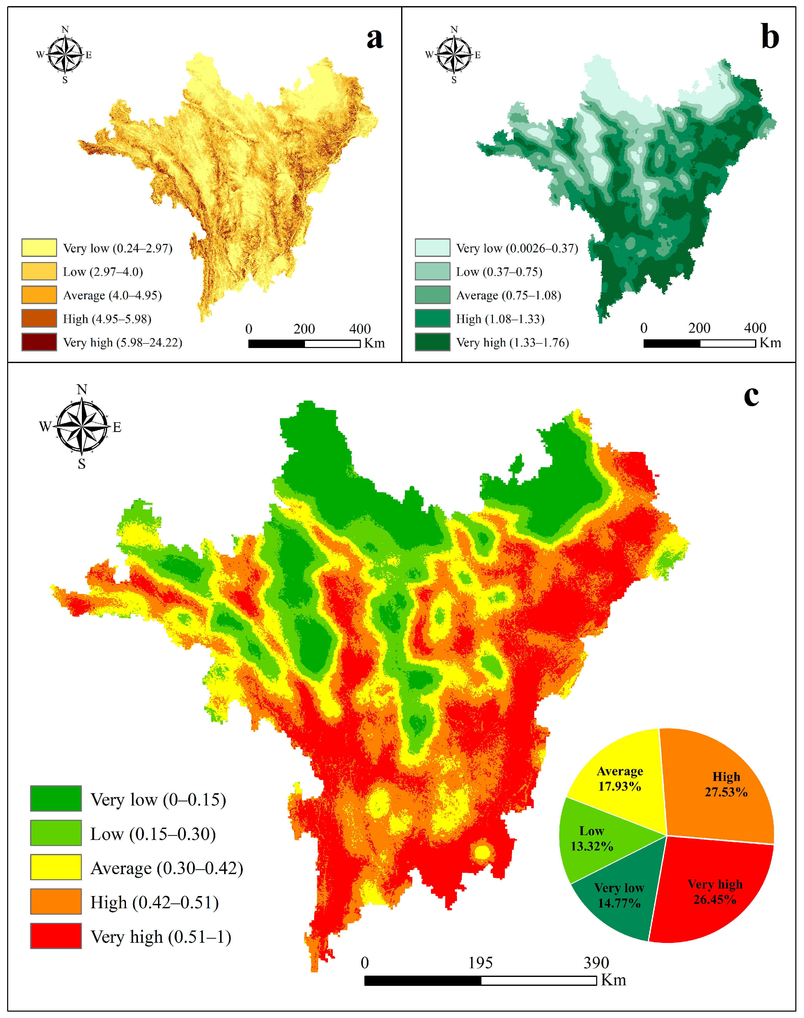
3.1. Attributes of LAQ

Figure 5a reveals the spatial pattern of geomorphic diversity characteristics in the Hengduan Mountains by evaluating the RDLS. The values of the RDLS range between 0.24 and 24.22, divided into five grades by the Jenks, and the break values are 2.97, 4.0, 4.95, and 5.98, respectively. Firstly, the study area’s RDLS (values) range between 5.98 and 24.22 (Very high) for about 9493.27 km2 (2.16%) and range between 4.95 and 5.98 (High) for about 36,495.33 km2 (8.31%). The areas (RDLS > 4.95) distributed along the Bershulla–Gaoligong Mountains, Nujiang Valley, Lancangjiang Valley, Jinshajiang Gorge, Yalong River Valley, Mount Daxue, the Dadu River Valley, the Qionglai Mountains, and Minjiang Valley in a north–south direction, where there are highly undulating alpine-valley landforms, world-rare deep valley landscapes, and alpine snow peak landscapes. The rich and varied landscape types are the reason for its relatively high LAQ. Secondly, the areas that range between 4.0 and 4.95 (Average, about 20.39%) are where plateau valleys are developing, cut shallowly, and multistage terraces are forming. Finally, low-value areas (RDLS < 4.0, about 69.13%) have high and medium mountain landforms with forming planation surfaces at the mountains’ top or have hilly plateau surfaces, broad valleys, and basins. The relatively gentle terrains are the reason why the RDLS is relatively low.
Figure 5b reveals the diverse characteristics of the ecological landscape patterns and landscape types of the Hengduan Mountains by evaluating SHDI. The values range between 0.0026 and 1.76. Overall, showing a high trend in the southeast and a low trend in the northwest, we divided them into five grades by the Jenks, with the break values of 0.37, 0.75, 1.08, and 1.33, respectively. Firstly, the study area’s SHDI (values) range between 1.33 and 1.76 (Very high) for about 115,957.61 km2 (26.74%) and range between 1.08 and 1.33 (High) for about 122,583.64 km2 (28.26%). The high-value areas (SHDI > 1.08) are distributed in the southern part of Bershulla, the Gaoligong Mountains, the southern part of Nujiang Valley, the southern part of Tenasserim Chain, Nushan, the southern part of Lancangjiang Valley, Yunling, the southern part of Jinshajiang Gorge, the middle-south part of Yalong River Valley, the Dadu River Valley, the Qionglai Mountains, Minjiang Valley, and the Minshan Mountains. There are concentrated distribution areas of forest landscapes such as evergreen needle leaf, evergreen broad leaf, deciduous broad leaf, mixed forest, or the transition zones between forest and meadow landscapes. The altitudinal belts of the natural landscapes are significant, with rich vegetation types and diverse landscape combinations, where the aesthetic value of the ecological landscapes is relatively high. While the low-value areas (SHDI < 0.75, about 27.87%) are consistent with the locations of herbaceous vegetation, where alpine meadows are spreading connectedly, the ecological landscape type is relatively singular.
Evaluating the attributes of the LAQ is based on the spatial overlay of the geomorphic and ecological landscape diversity (Figure 5c). After normalization, adopting the Jenks divided them into five grades, with break values of 0.15, 0.30, 0.42, and 0.51, respectively. The study area’s natural attributes (values) range between 0.51 and 1 (Very high) for about 114,411.22 km2 (26.45%). They are mainly distributed in the Gaoligong Mountains, the southern part of Nujiang Valley, Nushan, the middle-south part of Lancangjiang Valley, the middle part of Jinshajiang Gorge, the southern part of Yalong River Valley, the Dadu River Valley, the Qionglai Mountains, and Minjiang Valley, which have interlaced mountains and rivers, towering snow peaks, deep valleys, rich forest hierarchies, and diverse vegetation types. In general, the LAQ is relatively high.

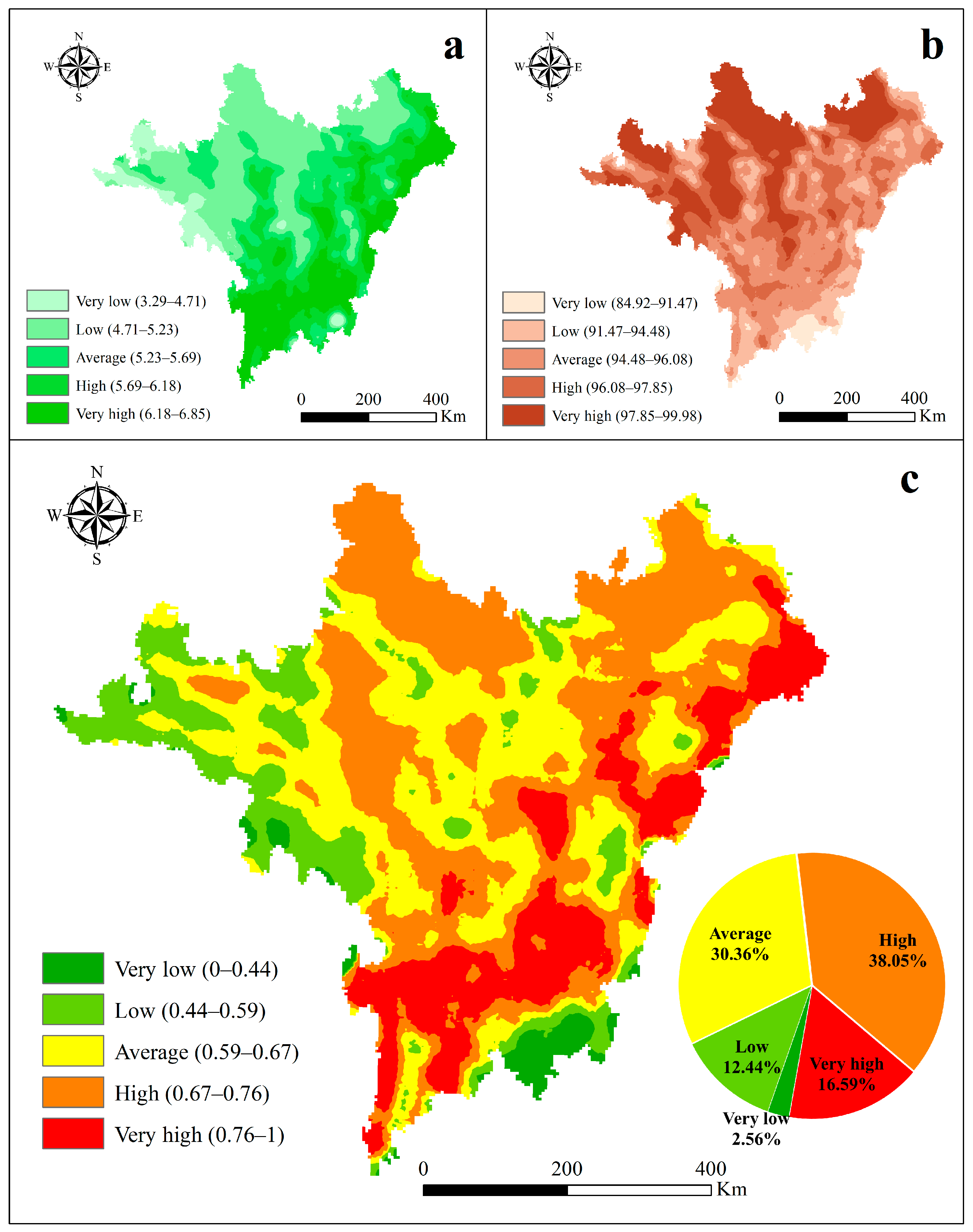
3.2. Characteristics of LAQ

The CI (values) range between 1.53 and 4.22, divided into five grades by the Jenks, with the break values being 2.12, 2.37, 2.61, and 3.12, respectively. Firstly, Figure 6a displays that only about 1206.57 km2 (0.28%) of the study area has CI (values) that range between 3.12 and 4.22 (Very high), distributed in the mountain ice/snow regions in the west Hengduan Mountains. Secondly, the study area’s CI (values) range between 2.61 and 3.12 (High) in about 92,111.53 km2 (21.24%). These areas are distributed in the Gaoligong Mountains, the southern part of Nujiang Valley, Nushan, the southern part of Lancangjiang Valley, Yunling, the middle-south part of Jinshajiang Gorge, the southern part of Yalong River Valley, the Dadu River Valley, Minjiang Valley, and the Minshan Mountains. There are towering snow peaks and glaciers, deciduous broad-leaved mixed forests, and coniferous broad-leaved mixed forests, which produce red maple forests, golden birch forests, verdurous spruce forests, and abundant alpine wildflowers. With seasonal changes, the diverse mixed forests form different color patterns. The higher the richness is of colored leaf species, the more fragmented and evenly distributed the color patches, and the higher the LAQ.
Figure 6b shows the spatial patterns of the vegetation interlaced zone’s combination to reflect the beauty of the landscape shape. The SI (values) range between 1.49 and 12.47, divided into five grades by the Jenks, with break values of 4.63, 6.61, 8.33, and 9.71, respectively. The study area’s SI (values) range between 9.71 and 12.47 (Very high) for about 104,310.64 km2 (24.05%) and range between 8.33 and 9.71 (High) for about 110,138.28 km2 (25.40%). These high-value areas account for approximately 50% of the study area. They are mainly distributed in the Gaoligong Mountains, the southern part of Nujiang Valley, Nushan, the southern part of Lancangjiang Valley, Yunling, the middle-south part of Jinshajiang Gorge, middle-south part of Yalong River Valley, the southern part of Mount Daxue, the Dadu River Valley, the Qionglai Mountains, Minjiang Valley, and the Minshan Mountains, where evergreen needle leaves, evergreen broad leaves, deciduous broad leaves, and mixed forests exist [28]. The interlaced distributions of rich forest landscapes, or forests and meadows, form different patch shape combinations in vertical and horizontal compositions. Here, the more complex the landscape interlaced zones and patch shapes are, the higher the spatial heterogeneities and the higher the LAQ.
Evaluating the value characteristics is performed in the light of the spatial overlay of the color and shape beauty (Figure 6c). After normalization, adopting the Jenks divided them into five grades, with the break values of 0.25, 0.43, 0.60, and 0.76, respectively. Here, the external characteristics (values) range between 0.76 and 1 (Very high) for about 117,366.49 km2 (27.06%). These high-value areas are distributed in the Gaoligong Mountains, the southern part of Nujiang Valley, Nushan, the southern part of Lancangjiang Valley, Yunling, the southern part of Jinshajiang Gorge, the southern part of Mount Shaluli, the southern part of Yalong River Valley, the Dadu River Valley, the southern part of Minjiang Valley, and the Minshan Mountains. The rich forests cause the value to be relatively high, regardless of whether there are seasonal color variations or vegetation interlaced zones with visual hierarchies. However, in the high-altitude areas in the central–northern and west Hengduan Mountains, the landscape is relatively singular in terms of shapes, colors, dynamics, and seasonal aspects.

3.3. Maintenance of LAQ

The AI (values) range between 3.29 and 6.85. The paper divided them into five grades by the Jenks, with break values of 4.71, 5.23, 5.69, and 6.18, respectively (Figure 7a). There, the study area’s AI (values) range between 6.18 and 6.85 (Very high) for about 87,545.96 km2 (20.19%) and range between 5.69 and 6.18 (High) for about 87,283.58 km2 (20.13%). These high-value areas (AI > 5.69) are distributed in the southern and eastern Hengduan Mountains, including the Gaoligong Mountains, the southern part of Nujiang Valley, Nushan, the southern part of Lancangjiang Valley, Yunling, the middle-south part of Jinshajiang Gorge, the southern part of Yalong River Valley, the Dadu River Valley, Minjiang Valley, and Minshan Mountains. The north–south valleys of the Hengduan Mountains are important water vapor channels. The warm moist airflows of the Indian Ocean provide abundant rainwater, which breeds dense primary forests in the eastern and southern Hengduan Mountains, and the authenticity of the nature-ecology landscapes is maintained well.
The CONT (values) range between 84.92 and 99.98, divided into five grades by the Jenks, and the break values are 91.47, 94.48, 96.08, and 97.85, respectively (Figure 7b). There, the study area’s CONT (values) range between 97.85 and 99.98 (Very high) for about 117,790.23 km2 (27.16%) and range between 96.08 and 97.85 (High) for about 100,335.90 km2 (23.13%). The high-value areas are distributed in the northwest Hengduan Mountains, including Bershulla, Tenasserim Chain, Mount Mangkang, the hilly plateau in northwest Sichuan, the middle-north part of Mount Shaluli, the northern part of Mount Daxue, and the Songpan plateau. The hills and mountain plains are rolling, and the landscape patches of herbaceous vegetation show a continuous distribution, presenting the vast beauty of the QTP.
Evaluating the maintenance state is performed in light of the spatial overlay of the authenticity and integrity (Figure 7c). After normalization, adopting the Jenks divided them into five grades, with break values of 0.44, 0.59, 0.67, and 0.76, respectively. Firstly, the study area’s maintenance state (values) range between 0.76 and 1 (Very high) for about 71,962.58 km2 (16.59%). They are distributed in the east and south Hengduan Mountains, including the Gaoligong Mountains, the southern part of Nujiang Valley, Nushan, the southern part of Lancangjiang Valley, Yunling, the southern part of Yalong River Valley, the Dadu River Valley, the southern part of the Qionglai Mountains, and the Minshan Mountains. There are thick primary forests, where alpine ecosystems and ecological landscapes are well preserved. Secondly, the study area’s maintenance state (values) ranges between 0.67 and 0.76 (High) for about 165,005.61 km2 (38.05%). These areas are distributed in the plateau in northwest Sichuan, where the alpine meadow ecosystems and ecological landscapes are relatively well preserved. It should be noted that the authenticity and integrity of the natural landscapes are opposite in the landscape aspects, and the Hengduan Mountains retained relatively integral and original natural ecosystems in general.

3.4. Comprehensive Evaluation of LAQ

The LAQ of the Hengduan Mountains is the comprehensive spatial overlays from the attributes, characteristics, and maintenance of landscape aesthetics (Figure 8). After normalization, adopting the Jenks divided them into five grades, with break values of 0.29, 0.44, 0.58, and 0.71, respectively. Here, the study area’s LAQ (values) range between 0.71 and 1 (Very high) for about 114,543.80 km2 (26.48%) and range between 0.58 and 0.71 (High) for about 82,904.73 km2 (19.16%). The high-value areas are distributed in the east and south Hengduan Mountains, including the southern part of Nujiang Valley, the southern part of Lancangjiang Valley, the middle-south part of Jinshajiang Gorge, the Gaoligong Mountains, Nushan, Yunling, the southern part of Yalong River Valley, the Dadu River Valley, the Qionglai Mountains, the southern part of Minjiang Valley, and the Minshan Mountains. Firstly, highly undulating mountain–valley landforms and complex vertical natural landscape zones exist here. The diversity indexes of geomorphic and ecological landscapes are relatively high, so the value attributes index is relatively high. Secondly, since there are rich vegetation types, the landscapes have relatively more seasonal color variations and apparent interlaced distributions, and the value characteristics index is relatively high. Thirdly, the thick primary forests remain, so the AI is relatively high. However, the integrity index is relatively low, with diverse landscape types and relatively small aggregation. Despite all of that, the comprehensive value maintenance index overlayed by the two is generally high.
In contrast, the study area’s LAQ (values) are lower than 0.58 for about 89,184.49 km2 (Average, 20.61%), 77,841.53 km2 (Low, 17.99%), and 68,145.05 km2 (Very low, 15.75%). These low-value areas are distributed in the middle–north and western Hengduan Mountains, including Bershulla, the Tenasserim Chain, Mount Mangkang, the plateau in northwest Sichuan, the northern part of Mount Shaluli, the northern part of Mount Daxue, and the Songpan plateau. The landscape types here are relatively singular, so the LAQ is relatively low.

4. Discussion

4.1. An Evaluation Framework of LAQ

This study attempted to establish an evaluation framework for the aesthetic quality of mountain natural landscapes by comprehensively evaluating the natural attributes, external characteristics, and maintenance state on a large scale. The LAQ was closely related to typical geomorphological features and rich ecosystem types. In this paper, evaluating the aesthetic quality of natural landscapes focused on the aesthetic object’s essential characteristics and natural attributes. Moreover, we considered the colors, shapes, seasonal aspects, dynamics, and other aesthetic characteristics of geomorphic and ecological elements and the landscape structure’s richness, combinations, and differences. The conclusion is that the high-value areas of landscape aesthetics are mainly distributed in the east and south Hengduan Mountains. These areas have towering snow peaks, magnificent glaciers, interlaced mountains and rivers, deep valleys, and complex and diverse landforms, which provide rich and colorful vegetation landscapes [29].

4.2. A Contribution to the Identification of National Parks

National parks are part of the most representative natural ecosystems, unique natural landscapes, essential natural heritages, and the wealthiest biodiversities in China [30]. China’s Natural Protected Areas System emphasizes the inclusion of “the most beautiful land” into national parks, where natural essence landscapes should exist with national and even global significance [31]. In this paper, the evaluated methodology of the aesthetic quality of natural landscapes can provide a meaningful reference for identifying national parks. From 2020 to 2023, we used unmanned aerial vehicles and cameras to take pictures and record the longitude and latitude from June to November for four consecutive years and validated them with the results of this study. Moreover, we found that the high-value areas correspond to China’s Giant Panda National Park spatially [32], confirming the methodology’s validity. In addition, we suggest that other protected areas of Jiuzhaigou [33], Huanglong [32], Gongga Mountain [34], Daocheng Yading [35], Pudatsuo in Shangri-La [36], Baima Snow Mountain [37], Yulong Snow Mountain, and the Gaoligong Mountains [38] should be considered as potential areas for National Parks (Figure 9). National Parks are excellent places to develop natural education, widespread science propaganda, and ecological experience. Interpreting and disseminating the scientific connotation of the aesthetic quality of natural landscapes in the Hengduan Mountains will strengthen the public’s awareness of ecological conservation and effectively promote the harmonious coexistence of humans and nature.

4.3. Limitations and Future Research

We want to explain that this paper evaluated and identified the aesthetic quality of natural landscapes in large-scale spaces. On the one hand, the input layers only contained land cover and DEM maps; the ranking of landscape types was based on expert evaluation and scientific visits, considering the audience’s perception and conducting questionnaires in later research; the fewer input layers led to the spatial correlation between indicators (both positive and negative). On the other hand, the grid of cropped images was 10 km × 10 km; the interpolation method of landscape indexes was Kriging; the overlayed results used the equal weight method.
However, the evaluated methodology of the LAQ can serve as a comprehensive reference for identifying spaces for future national parks’ essence landscapes in the Hengduan Mountains. Moreover, on this basis, we will carry out a more high-accuracy identification of LAQ spaces for an individual national park at medium-small scales in the next step (the grid is 1 km × 1 km).
The second explanation is that this paper mainly evaluated the aesthetic quality of natural landscapes, emphasizing originality and naturalness. Next, we can conduct evaluation research on the aesthetic quality of ecological villages and rural scenery. Meanwhile, the evaluation was concerned with the landscape pattern for the year 2019. In the future, we will explore the dynamic development and causal mechanism of landscape aesthetics in a long-term time series.

5. Conclusions

This paper mapped the relationship between natural landscape beauty’s physical characteristics and service functions. Considering the LAQ’s natural attributes, external characteristics, and maintenance state, a methodology for evaluating the aesthetic quality of large-scale natural landscapes was built. Firstly, landscape diversity formed by geomorphic diversity and ecological diversity is a natural property of the large-scale LAQ. The high LAQ area of the Hengduan Mountains is characterized by highly undulating alpine canyon landforms, prominent vertical bands of natural landscapes, rich vegetation types, and diverse landscape combinations. The rich and diverse landscape types are the reason for its high LAQ. Secondly, color and shape are the external aesthetic characteristics of large-scale natural landscapes. The high LAQ area of the Hengduan Mountains is rich in colorful leaf species, and the forest and meadow are staggered, forming different patch-like combinations. Different vegetation landscapes showed different seasonal characteristics with the change in season, and landscape groups showed different morphological characteristics with the change in altitude. Thirdly, the authenticity of natural elements and the integrity of landscape patterns reflected the maintenance state of the aesthetic quality of natural landscapes. Finally, the key areas of the natural essence landscapes of the Hengduan Mountains were identified by spatially overlaying the above three aspects. They are mainly distributed in the east and south Hengduan Mountains, including the southern part of Nujiang Valley, the southern part of Lancangjiang Valley, the middle-south part of Jinshajiang Gorge, Gaoligong Mountains, Nushan, Yunling, the southern part of Yalong River Valley, Dadu River Valley, Qionglai Mountains, the southern part of Minjiang Valley, and Minshan Mountains. Here, the vegetation landscapes are diverse, and the forest landscape hierarchies are rich, forming vertical differentiation, horizontal change, and colorful natural ecological landscapes, which are highly ornamental. The grading evaluation of the LAQ can provide decision support for classified protection and rational utilization of landscape resources. This paper proposed that the scientific connotation of the aesthetic quality of mountain natural landscapes should be interpreted and spread through nature education and the popularization of science and ecological experience to establish the public’s awareness of ecological protection and promote the harmonious coexistence of man and nature.

Author Contributions

Conceptualization, S.D. and Z.Y.; methodology, S.D.; software, S.D. and F.H.; formal analysis, S.D. and F.H.; writing–original draft, S.D.; resources, Z.Y.; writing—review and editing, F.H.; supervision, F.H.; funding acquisition, F.H. All authors have read and agreed to the published version of the manuscript.

Funding

This work was supported by the Second Tibetan Plateau Scientific Expedition and Research Program (STEP, Grant No. 2019QZKK0401) and the “Tianshan Talents” training program (No. 2023TSYCCX0088).

Data Availability Statement

Data will be made available on request. Please contact [email protected] (S.D.).

Conflicts of Interest

The authors declare no conflicts of interest.

References

  1. Gobster, P.H.; Nassauer, J.I.; Daniel, T.C.; Fry, G. The Shared Landscape: What Does Aesthetics Have to Do with Ecology? Landsc. Ecol. 2007, 22, 959–972. [Google Scholar] [CrossRef]
  2. Schirpke, U.; Tasser, E.; Tappeiner, U. Predicting Scenic Beauty of Mountain Regions. Landsc. Urban Plan. 2013, 111, 1–12. [Google Scholar] [CrossRef]
  3. Hermes, J.; Albert, C.; von Haaren, C. Assessing the Aesthetic Quality of Landscapes in Germany. Ecosyst. Serv. 2018, 31, 296–307. [Google Scholar] [CrossRef]
  4. Kalinauskas, M.; Mikša, K.; Inácio, M.; Gomes, E.; Pereira, P. Mapping and Assessment of Landscape Aesthetic Quality in Lithuania. J. Environ. Manag. 2021, 286, 112239. [Google Scholar] [CrossRef] [PubMed]
  5. Swanwick, C. Landscape Character Assessment: Guidance for England and Scotland; Prepared on Behalf of the Countryside Agency and Scottish Natural Heritage. 2002. Available online: https://digital.nls.uk/pubs/e-monographs/2020/216649977.23.pdf (accessed on 1 August 2024).
  6. Seekamp, E.; Cerveny, L.K.; McCreary, A. Institutional, Individual, and Socio-Cultural Domains of Partnerships: A Typology of USDA Forest Service Recreation Partners. Environ. Manag. 2011, 48, 615–630. [Google Scholar] [CrossRef] [PubMed]
  7. Frank, S.; Fürst, C.; Koschke, L.; Witt, A.; Makeschin, F. Assessment of Landscape Aesthetics—Validation of a Landscape Metrics-Based Assessment by Visual Estimation of the Scenic Beauty. Ecol. Indic. 2013, 32, 222–231. [Google Scholar] [CrossRef]
  8. Schüpbach, B.; Junge, X.; Lindemann-Matthies, P.; Walter, T. Seasonality, Diversity and Aesthetic Valuation of Landscape Plots: An Integrative Approach to Assess Landscape Quality on Different Scales. Land Use Policy 2016, 53, 27–35. [Google Scholar] [CrossRef]
  9. Kerebel, A.; Gélinas, N.; Déry, S.; Voigt, B.; Munson, A. Landscape Aesthetic Modelling Using Bayesian Networks: Conceptual Framework and Participatory Indicator Weighting. Landsc. Urban Plan. 2019, 185, 258–271. [Google Scholar] [CrossRef]
  10. Schirpke, U.; Zoderer, B.M.; Tappeiner, U.; Tasser, E. Effects of Past Landscape Changes on Aesthetic Landscape Values in the European Alps. Landsc. Urban Plan. 2021, 212, 104109. [Google Scholar] [CrossRef]
  11. Zongxing, L.; He, Y.; Wang, P.; Theakstone, W.H.; An, W.; Wang, X.; Lu, A.; Zhang, W.; Cao, W. Changes of Daily Climate Extremes in Southwestern China during 1961–2008. Glob. Planet. Chang. 2012, 80–81, 255–272. [Google Scholar] [CrossRef]
  12. Chang, C.-F.; Pan, Y.-S.; Sun, Y.-Y. The Tectonic Evolution of Qinghai-Tibet Plateau: A Review. In Tectonic Evolution of the Tethyan Region; Şengör, A.M.C., Ed.; Springer: Dordrecht, The Netherlands, 1989; pp. 415–476. ISBN 978-94-009-2253-2. [Google Scholar]
  13. Sun, D.-L.; Yao, B.-M.; Yang, G.; Sun, G.-X. Climate and Soil Properties Regulate the Vertical Heterogeneity of Minor and Trace Elements in the Alpine Topsoil of the Hengduan Mountains. Sci. Total Environ. 2023, 899, 165653. [Google Scholar] [CrossRef] [PubMed]
  14. Dai, E.; Wang, Y. Attribution Analysis for Water Yield Service Based on the Geographical Detector Method: A Case Study of the Hengduan Mountain Region. J. Geogr. Sci. 2020, 30, 1005–1020. [Google Scholar] [CrossRef]
  15. Sun, H.; Zhang, J.; Deng, T.; Boufford, D.E. Origins and Evolution of Plant Diversity in the Hengduan Mountains, China. Plant Divers 2017, 39, 161–166. [Google Scholar] [CrossRef]
  16. Leser, H.; Nagel, P. Landscape Diversity—A Holistic Approach. In Biodiversity: A Challenge for Development Research and Policy; Barthlott, W., Winiger, M., Biedinger, N., Eds.; Springer: Berlin/Heidelberg, Germany, 2001; pp. 129–143. ISBN 978-3-662-06071-1. [Google Scholar]
  17. Ren, Y.; Lü, Y.; Hu, J.; Yin, L. Geodiversity Underpins Biodiversity but the Relations Can Be Complex: Implications from Two Biodiversity Proxies. Glob. Ecol. Conserv. 2021, 31, e01830. [Google Scholar] [CrossRef]
  18. Feng, Z.M.; Li, W.J.; Li, P.; Xiao, C.W. Relief Degree of Land Surface and Its Geographical Meanings in the Qinghai-Tibet Plateau, China. Acta Geogr. Sin 2020, 75, 1359–1372. [Google Scholar]
  19. Hietala-Koivu, R.; Lankoski, J.; Tarmi, S. Loss of Biodiversity and Its Social Cost in an Agricultural Landscape. Agric. Ecosyst. Environ. 2004, 103, 75–83. [Google Scholar] [CrossRef]
  20. Yin, L.; Dai, E.; Zheng, D.; Wang, Y.; Ma, L.; Tong, M. What Drives the Vegetation Dynamics in the Hengduan Mountain Region, Southwest China: Climate Change or Human Activity? Ecol. Indic. 2020, 112, 106013. [Google Scholar] [CrossRef]
  21. Wang, Z.; Li, M.; Zhang, X.; Song, L. Modeling the Scenic Beauty of Autumnal Tree Color at the Landscape Scale: A Case Study of Purple Mountain, Nanjing, China. Urban For. Urban Green. 2020, 47, 126526. [Google Scholar] [CrossRef]
  22. Brielmann, A.A.; Dayan, P. A Computational Model of Aesthetic Value. Psychol. Rev. 2022, 129, 1319–1337. [Google Scholar] [CrossRef] [PubMed]
  23. Pott, R. Effects of Human Interference on the Landscape with Special Reference to the Role of Grazing Livestock. In Grazing and Conservation Management; WallisDeVries, M.F., Van Wieren, S.E., Bakker, J.P., Eds.; Conservation Biology Series; Springer: Dordrecht, The Netherlands, 1998; pp. 107–134. ISBN 978-94-011-4391-2. [Google Scholar]
  24. Walz, U.; Stein, C. Indicators of Hemeroby for the Monitoring of Landscapes in Germany. J. Nat. Conserv. 2014, 22, 279–289. [Google Scholar] [CrossRef]
  25. Sowifska-fwierkosz, B. Index of Landscape Disharmony (ILDH) as a New Tool Combining the Aesthetic and Ecological Approach to Landscape Assessment. Ecol. Indic. 2016, 70, 166–180. [Google Scholar] [CrossRef]
  26. Chang Chien, Y.-M.; Carver, S.; Comber, A. Using Geographically Weighted Models to Explore How Crowdsourced Landscape Perceptions Relate to Landscape Physical Characteristics. Landsc. Urban Plan. 2020, 203, 103904. [Google Scholar] [CrossRef]
  27. Zou, L.; Wang, J.; Bai, M. Assessing Spatial–Temporal Heterogeneity of China’s Landscape Fragmentation in 1980–2020. Ecol. Indic. 2022, 136, 108654. [Google Scholar] [CrossRef]
  28. Yao, Y.; Zhang, B.; Han, F.; Pang, Y. Diversity and Geographical Pattern of Altitudinal Belts in the Hengduan Mountains in China. J. Mt. Sci. 2010, 7, 123–132. [Google Scholar] [CrossRef]
  29. Wang, J.; Liang, S.; Shi, P. Topography and Landforms. In The Geography of Contemporary China; Wang, J., Liang, S., Shi, P., Eds.; Springer International Publishing: Cham, Switzerland, 2022; pp. 63–84. ISBN 978-3-031-04158-7. [Google Scholar]
  30. Du, A.; Xu, W.; Xiao, Y.; Cui, T.; Song, T.; Ouyang, Z. Evaluation of Prioritized Natural Landscape Conservation Areas for National Park Planning in China. Sustainability 2020, 12, 1840. [Google Scholar] [CrossRef]
  31. Li, J.; Wang, W.; Axmacher, J.C.; Zhang, Y.; Zhu, Y. Streamlining China’s Protected Areas. Science 2016, 351, 1160. [Google Scholar] [CrossRef] [PubMed]
  32. Huang, Q.; Fei, Y.; Yang, H.; Gu, X.; Songer, M. Giant Panda National Park, a Step towards Streamlining Protected Areas and Cohesive Conservation Management in China. Glob. Ecol. Conserv. 2020, 22, e00947. [Google Scholar] [CrossRef]
  33. Wang, L.; Pan, Y.; Cao, Y.; Li, B.; Wang, Q.; Wang, B.; Pang, W.; Zhang, J.; Zhu, Z.; Deng, G. Detecting Early Signs of Environmental Degradation in Protected Areas: An Example of Jiuzhaigou Nature Reserve, China. Ecol. Indic. 2018, 91, 287–298. [Google Scholar] [CrossRef]
  34. Qiao, J.; Jia, G.; Zhou, H.; Gong, L.; Jiang, Y.; Xiao, N.; Gao, X.; Wen, A.; Wang, J. Mammal and Bird Diversity Recorded with Camera Traps in Gongga Mountain National Nature Reserve, Sichuan, China. Biodivers. Sci. 2022, 30, 20395. [Google Scholar] [CrossRef]
  35. Chen, D.; Zhong, L.; Fan, J.; Yu, H.; Yang, D.; Zeng, Y. Evaluation and Structural Analysis of the Functions of the Tibetan Plateau National Park Cluster. J. Geogr. Sci. 2022, 32, 957–980. [Google Scholar] [CrossRef]
  36. Zhou, D.Q.; Edward Grumbine, R. National Parks in China: Experiments with Protecting Nature and Human Livelihoods in Yunnan Province, Peoples’ Republic of China (PRC). Biol. Conserv. 2011, 144, 1314–1321. [Google Scholar] [CrossRef]
  37. Yang, Y.; Shen, Z.; Han, J.; Zhongyong, C. Plant Diversity along the Eastern and Western Slopes of Baima Snow Mountain, China. Forests 2016, 7, 89. [Google Scholar] [CrossRef]
  38. Li, Q.; Li, X.-Y.; Hu, W.-Q.; Song, W.-Y.; He, S.-W.; Wang, H.-J.; Hu, Z.-C.; Li, M.-C.; Onditi, K.O.; Chen, Z.-Z.; et al. The Mammals of Gaoligong Mountain in China: Diversity, Distribution, and Conservation. Zool. Res. Divers. Conserv. 2024, 1, 3–19. [Google Scholar] [CrossRef]
Figure 1. Location and mountain valleys of the Hengduan Mountains region, Southwest China. The map is from the Chinese Standard Map (http://bzdt.ch.mnr.gov.cn/GS(2020)4619), (accessed on 1 August 2022).
Land 13 01278 g001
Figure 2. Typical natural landscapes of the Hengduan Mountains region.
Land 13 01278 g002
Figure 3. Land cover types in the Hengduan Mountains region.
Land 13 01278 g003
Figure 4. Methodological framework for LAQ evaluation.
Land 13 01278 g004
Figure 5. Evaluation results of landscape natural attributes, (a) diversity of geomorphic landscape, (b) diversity of ecological landscape, (c) natural attributes of LAQ.
Land 13 01278 g005
Figure 6. Evaluation results of landscape external characteristics, (a) beauty of landscape color, (b) beauty of landscape shape, (c) external characteristics of LAQ.
Land 13 01278 g006
Figure 7. Evaluation results of landscape maintenance state, (a) authenticity of landscape elements, (b) integrity of landscape pattern, (c) maintenance state of LAQ.
Land 13 01278 g007
Figure 8. Spatial distribution of LAQ.
Land 13 01278 g008
Figure 9. Construction of potential areas of national parks.
Land 13 01278 g009
Table 1. Color beauty value of landscape types.
Landscape TypeCBi
Snow and ice; Permanent water bodies; Closed forest, deciduous broad leaf; Closed forest, mixed; Open forest, deciduous broad leaf; Open forest, mixed5
Shrubs4
Closed forest, evergreen needle leaf; Closed forest, evergreen broad leaf; Open forest, evergreen needle leaf; Open forest, evergreen broad leaf3
Herbaceous vegetation; Herbaceous wetland; Moss and lichen; Closed forest, unknown; Open forest, unknown2
Cultivated and managed vegetation/agriculture (cropland); Urban/built up; Bare/sparse vegetation1
Table 2. Authenticity value of landscape types.
Landscape TypeAVi
Closed forest, evergreen needle leaf; Closed forest, evergreen broad leaf; Closed forest, deciduous broad leaf; Closed forest, mixed; Closed forest, unknown7
Open forest, evergreen needle leaf; Open forest, evergreen broad leaf; Open forest, deciduous broad leaf; Open forest, mixed; Open forest, unknown6
Shrubs; Herbaceous vegetation; Snow and ice; Herbaceous wetland; Moss and lichen5
Permanent water bodies4
Bare/sparse vegetation3
Cultivated and managed vegetation/agriculture (cropland)2
Urban/built up1
Disclaimer/Publisher’s Note: The statements, opinions and data contained in all publications are solely those of the individual author(s) and contributor(s) and not of MDPI and/or the editor(s). MDPI and/or the editor(s) disclaim responsibility for any injury to people or property resulting from any ideas, methods, instructions or products referred to in the content.

