
Geochemical Behavior of Rare Earth Elements in Tidal Flat Sediments from Qidong Cape, Yangtze River Estuary: Implications for the Study of Sedimentary Environmental Change


Abstract
:1. Introduction
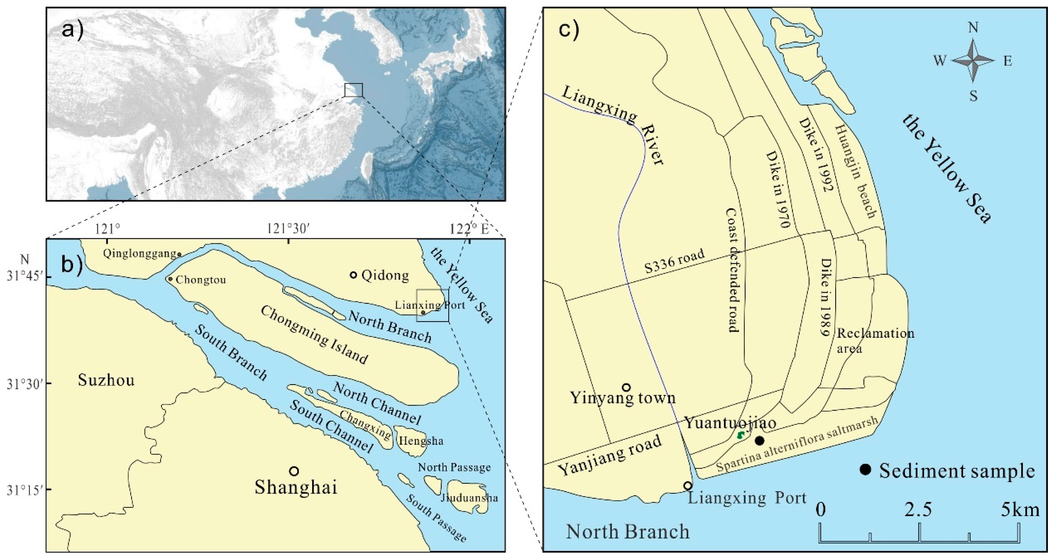
2. Study Area
3. Materials and Methods
3.1. Sampling
3.2. Laboratory Analyses
3.3. Data Processing
4. Results
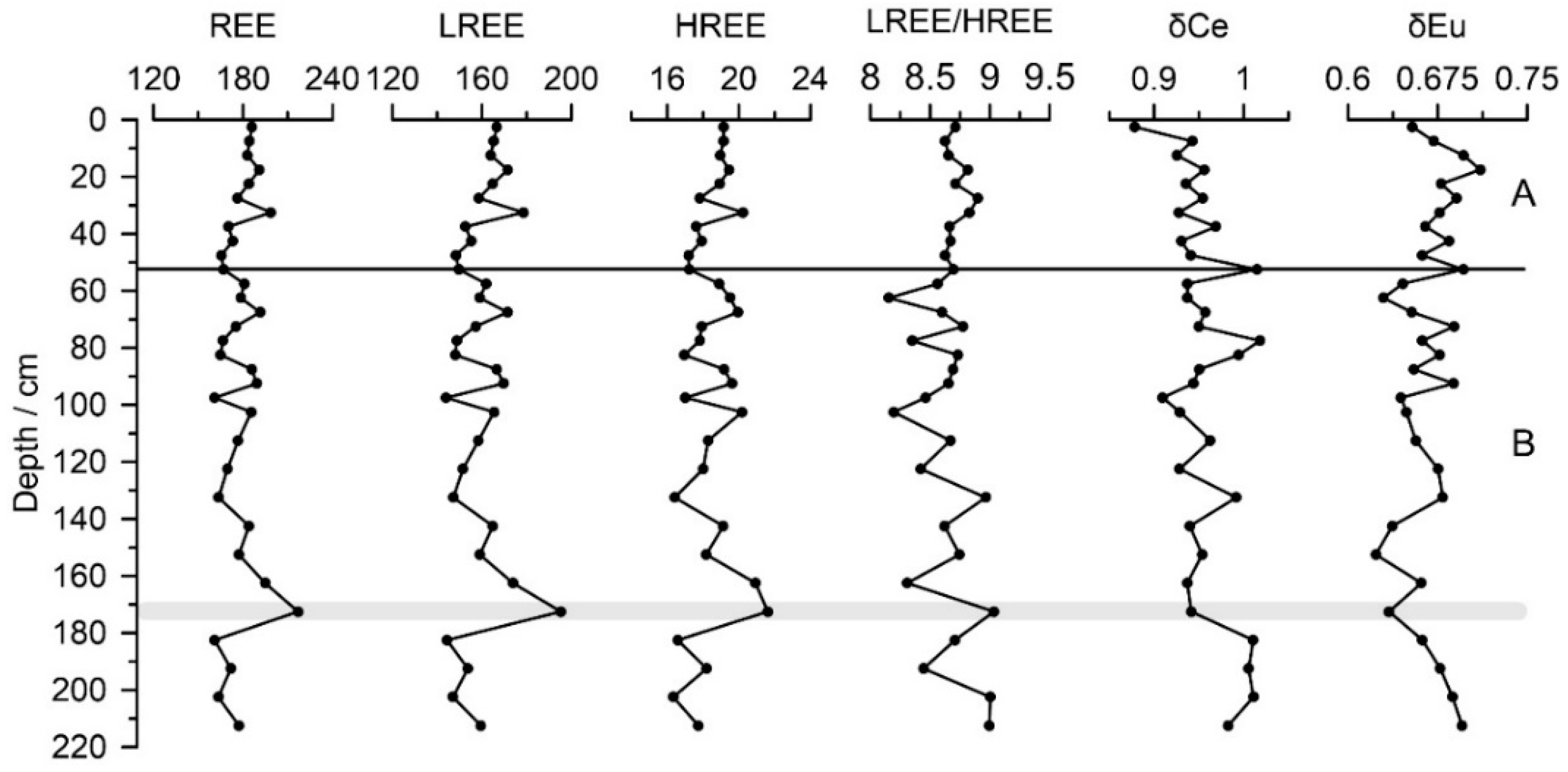
4.1. REE Concentration
4.2. REE-Normalized Patterns
5. Discussion
5.1. Anomalies of Ce and Eu
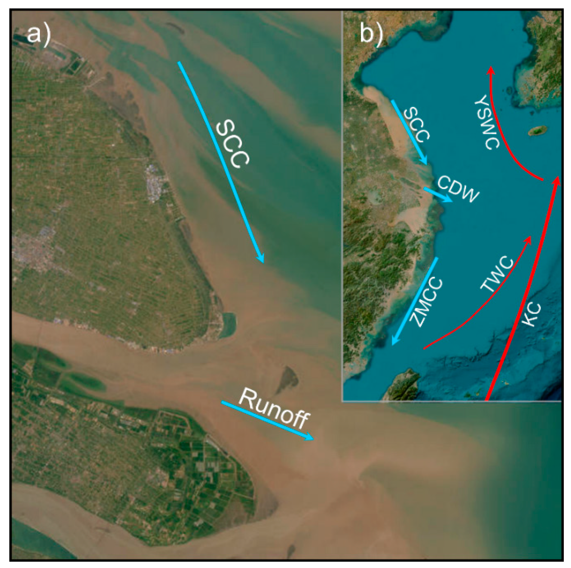
5.2. Discrimination of Sediment Source
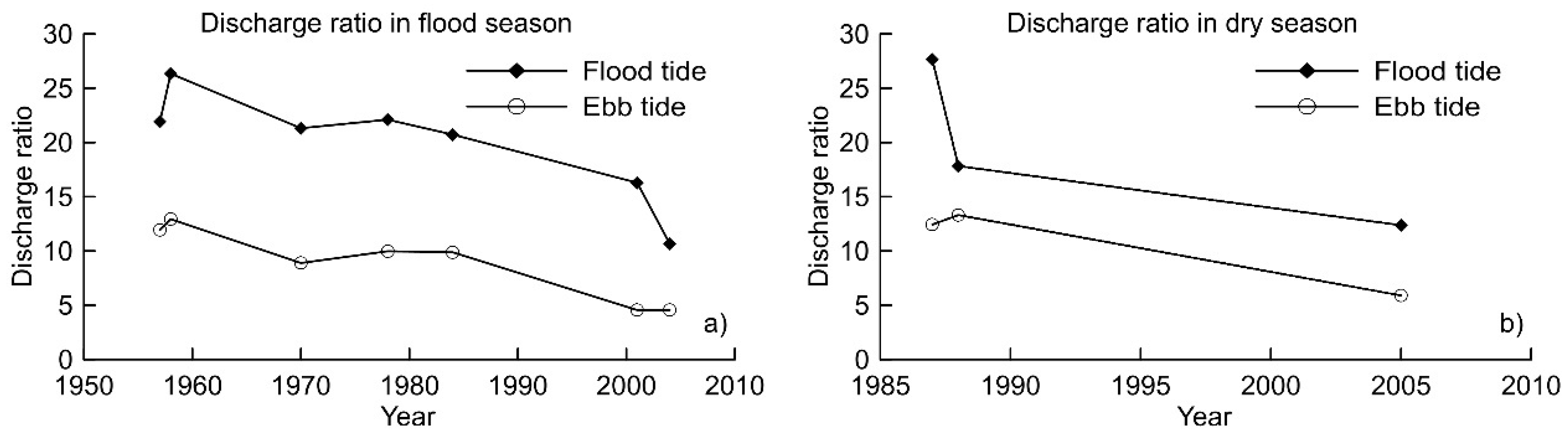
5.3. Change in Sedimentary Dynamic
6. Conclusions
Author Contributions
Funding
Data Availability Statement
Acknowledgments
Conflicts of Interest
References
- Walling, D.E.; Fang, D. Recent trends in the suspended sediment loads of the world’s rivers. Glob. Planet. Change 2003, 39, 111–126. [Google Scholar] [CrossRef]
- Walling, D.E. Human impact on land-ocean sediment transfer by the world’s rivers. Geomorphology 2006, 79, 192–216. [Google Scholar] [CrossRef]
- Vörösmarty, C.J.; Meybeck, M.; Fekete, B.; Sharma, K.; Green, P.; Syvitski, J.P.M. Anthropogenic sediment retention: Major global impact from registered river impoundments. Glob. Planet. Chang. 2003, 39, 169–190. [Google Scholar] [CrossRef]
- Syvitski, J.P.M.; Vörösmarty, C.J.; Kettner, A.J.; Green, P. Impact of humans on the flux of terrestrial sediment to the global coastal ocean. Science 2005, 308, 376–380. [Google Scholar] [PubMed]
- Syvitski, J.P.M. Supply and flux of sediment along hydrological pathways: Research for the 21st century. Glob. Planet. Chang. 2003, 39, 1–11. [Google Scholar] [CrossRef]
- Abd-El Monsef, H.; Smith, S.E.; Darwish, K. Impacts of the Aswan High Dam after 50 years. Water. Resour. Manag. 2015, 29, 1873–1885. [Google Scholar] [CrossRef]
- Ghoneim, E.; Mashaly, J.; Gamble, D.; Halls, J.; Abu-Bakr, M. Nile Delta exhibited a spatial reversal in the rates of shoreline retreat on the Rosetta promontory comparing pre-and post-beach protection. Geomorphology 2015, 228, 1–14. [Google Scholar] [CrossRef]
- Liu, F.; Yang, Q.S.; Chen, S.L.; Luo, Z.F.; Yuan, F.; Wang, R.T. Temporal and spatial variability of sediment flux into the sea from the three largest rivers in China. J. Asian. Earth. Sci. 2014, 87, 102–115. [Google Scholar]
- Dai, S.B.; Lu, X.X. Sediment load change in the Yangtze River (Changjiang): A review. Geomorphology 2014, 215, 60–73. [Google Scholar] [CrossRef]
- Dai, Z.J.; Chu, A.; Stive, M.; Du, J.Z.; Li, J.F. Is the Three Georges Dam the cause behind the 2006 extreme low suspended sediment discharge into the Yangtze (Changjiang) estuary? Hydrolog. Sci. J. 2011, 56, 1280–1288. [Google Scholar] [CrossRef]
- Dai, Z.J.; Liu, J.T. Impacts of large dams on downstream fluvial sedimentation: An example of the Three Gorges Dam (TGD) on the Changjiang (Yangtze River). J. Hydrol. 2013, 480, 10–18. [Google Scholar] [CrossRef]
- Yang, S.L.; Belkin, I.M.; Belkina, A.I.; Zhao, Q.Y.; Zhu, J.; Ding, P.X. Delta response to decline in sediment supply from the Yangtze River: Evidence of the recent four decades and expectations for the next half century. Estuar. Coast. Shelf. S 2003, 57, 689–699. [Google Scholar] [CrossRef]
- Yang, S.L.; Milliman, J.D.; Li, P.; Xu, K. 50,000 Dams later: Erosion of the Yangtze River and its delta. Glob. Planet. Chang. 2011, 75, 14–20. [Google Scholar] [CrossRef]
- Yang, H.F.; Yang, S.L.; Xu, K.H.; Milliman, J.D.; Wang, H.; Yang, Z.; Chen, Z.; Zhang, C.Y. Human impacts on sediment in the Yangtze River: A review and new perspectives. Glob. Planet. Chang. 2018, 162, 8–17. [Google Scholar]
- Wan, Y.Y.; Gu, F.F.; Wu, H.L.; Roelvink, D. Hydrodynamic evolutions at the Yangtze Estuary from 1998 to 2009. Appl. Ocean. Res 2014, 47, 291–302. [Google Scholar] [CrossRef]
- Zhou, J.Y.; Chen, Z.B.; Hu, D.C.; Jiang, L.; Zeng, X. Measures for mitigating the shrinking of the North Branch of Changjiang Estuary. E3S Web Conf. 2023, 393, 02027. [Google Scholar] [CrossRef]
- Yu, S.P.; Yang, J.S.; Liu, G.M. Impact assessment of Three Gorges Dam’s impoundment on river dynamics in the north branch of Yangtze River estuary, China. Environ. Earth. Sci. 2014, 74, 499–509. [Google Scholar]
- Zhang, Y.F.; Zhang, Z.K.; Liu, Y.Q.; Zhang, H.B.; Chen, Y.Y. Sediment dynamic processes in North Branch of Yangtze River Estuary and response to human activities. Yangtze River 2019, 50, 24–29. (In Chinese) [Google Scholar]
- Xu, F.J.; Li, A.C.; Li, T.G.; Xu, K.H.; Chen, S.Y.; Qiu, L.W.; Cao, Y.C. Rare earth element geochemistry in the inner shelf of the East China Sea and its implication to sediment provenances. J. Rare Earths 2011, 29, 702–709. [Google Scholar] [CrossRef]
- Hannigan, R.; Dorval, E.; Jones, C. The rare earth element chemistry of estuarine surface sediments in the Chesapeake Bay. Chem. Geol. 2010, 272, 20–30. [Google Scholar]
- Kim, I.; Kim, G. Submarine groundwater discharge as a main source of rare earth elements in coastal waters. Mar. Chem. 2014, 160, 11–17. [Google Scholar] [CrossRef]
- Fiket, Ž.; Mikac, N.; Kniewald, G. Influence of the geological setting on the REE geochemistry of estuarine sediments: A case study of the Zrmanja River estuary (eastern Adriatic coast). J. Geochem. Explor. 2017, 182, 70–79. [Google Scholar] [CrossRef]
- Brito, P.; Prego, R.; Mil-Homens, M.; Caçador, I.; Caetano, M. Sources and distribution of yttrium and rare earth elements in surface sediments from Tagus estuary, Portugal. Sci. Total Environ. 2018, 621, 317–325. [Google Scholar] [PubMed]
- Almenningen, S.; Roy, S.; Hussain, A.; Seland, J.G.; Ersland, G. Effect of mineral composition on transverse relaxation time distributions and MR imaging of tight rocks from offshore Ireland. Minerals 2020, 10, 232. [Google Scholar] [CrossRef]
- Astakhova, N.V.; Sattarova, V.V. The REE species and their distribution in ferromanganese crusts in the Sea of Japan. Russ. Geol. Geophys. 2012, 53, 649–656. [Google Scholar] [CrossRef]
- kwon Um, I.; Choi, M.S.; Bahk, J.J.; Song, Y.H. Discrimination of sediment provenance using rare earth elements in the Ulleung Basin, East/Japan Sea. Mar. Geol. 2013, 346, 208–219. [Google Scholar]
- Lim, D.; Jung, H.S.; Choi, J.Y. REE partitioning in riverine sediments around the Yellow Sea and its importance in shelf sediment provenance. Mar. Geol. 2014, 357, 12–24. [Google Scholar] [CrossRef]
- Silva, M.M.V.G.; Lopes, S.P.; Gomes, E.C. Geochemistry and behavior of REE in stream sediments close to an old Sn-W mine, Ribeira, Northeast Portugal. Geochemistry 2014, 74, 545–555. [Google Scholar] [CrossRef]
- Xu, N.; Morgan, B.; Rate, A.W. From source to sink: Rare-earth elements trace the legacy of sulfuric dredge spoils on estuarine sediments. Sci. Total Environ. 2018, 637–638, 1537–1549. [Google Scholar]
- Zhang, Y.H.; Huang, G.M.; Wang, W.Q.; Chen, L.Z.; Lin, G.H. Interactions between mangroves and exotic Spartina in an anthropogenically disturbed estuary in southern China. Ecology 2012, 93, 588–597. [Google Scholar]
- Zhang, Z.K.; Xie, L.; Cong, N.; Li, Y.; Wang, X.N.; He, H.C. Recent morphological changes of tidal flat at Yuantuojiao Point, estuary of the north branch of the Yangtze River. Geogr. Res. 2010, 29, 909–916. (In Chinese) [Google Scholar]
- Gao, Y.; Zhang, L.Z.; Zhang, T.T.; Liu, J.Y.; Song, C.; Zhuang, P. The status of wetland conservation and management, the existing problems and solution ways in the Yangtze Estuary. Wetl. Sci. 2017, 15, 302–308. (In Chinese) [Google Scholar]
- Zhang, Z.K.; Li, Y.M.; Meng, H.M.; Wang, W.F.; He, H.C.; Jiang, S.L. Grain size and its environmental significance of the core from the tidal flat at Yuantuojiao point, Jiangsu Province. Quat. Sci. 2008, 28, 690–694. (In Chinese) [Google Scholar]
- Zhang, Y.F.; Zhang, Z.K.; Ding, H.Y.; Chen, Y.Y. The sensitive grain-size components of core sediments and environmental significance at tidal flat around Qidong cape, Jiangsu province. Mar. Environ. Sci. 2021, 40, 81–86. (In Chinese) [Google Scholar]
- Zhang, Y.F.; Zhang, Z.K.; Ren, H.; Chen, Y.Y. The sedimentation rates of tidal flat and environmental significance at Qidong foreland of the Yangtze Estuary. T. Oceanol. Limnol. 2018, 40, 36–43. (In Chinese) [Google Scholar]
- Xie, L.; Zhang, Z.K.; Zhang, Y.F.; Wang, Y.P.; Huang, X.J. Sedimentation and morphological changes at Yuantuojiao Point, estuary of the North Branch, Changjiang River. Acta Oceanol. Sin. 2013, 32, 24–34. [Google Scholar] [CrossRef]
- Zhang, Y.F.; Zhang, Z.K.; He, H.C.; Chen, Y.Y.; Jiang, S.L.; Ren, H. Processes of small-scale tidal flat accretion and salt marsh changes on the plain coast of Jiangsu Province, China. Acta Oceanol. Sin. 2017, 36, 80–86. [Google Scholar] [CrossRef]
- Hussain, A.; Morris, E.A.; Al-Ramadan, K.; Shannon, P.M.; Haughton, P.D. Hybrid event beds (HEBs) and the ‘greywacke problem’ revisited. Earth-Sci. Rev. 2023, 237, 104297. [Google Scholar]
- Gao, J.F.; Lu, J.J.; Lai, M.Y.; Lin, Y.P.; Pu, W. Analysis of trace elements in rock samples using HROICPMS. J. Nanjing Univ. (Nat. Sci.) 2003, 39, 844–850. (In Chinese) [Google Scholar]
- Leybourne, M.I.; Johannesson, K.H. Rare earth elements (REE) and yttrium in stream waters, stream sediments, and Fe-Mn oxyhydroxides: Fractionation, speciation, and controls over REE + Y patterns in the surface environment. Geochim. Cosmochim. Acta 2008, 72, 5962–5983. [Google Scholar]
- Boynton, W.V. Chapter 3—Cosmochemistry of the rare earth elements: Meteorite studies. Dev. Geochem. 1984, 2, 63–114. [Google Scholar]
- Minai, Y.; Matsumoto, R.; Watanabe, Y.; Tominaga, T. Geochemistry of rare earths and other trace elements in sediments from sites 798 and 799, Japan sea. Proc. Ocean. Drill. Prog. Sci. Results 1992, 127–128, 719–737. [Google Scholar]
- Xu, G.; Liu, J.; Kong, X.H.; Zhang, J.Q.; Qiu, J.D. Rare earth elements in surface sediments of western south yellow sea and their provenance implications. Mar. Geol. Quat. Geol. 2012, 32, 11–17. (In Chinese) [Google Scholar] [CrossRef]
- Yang, S.Y.; Jung, H.S.; Choi, M.S.; Li, C.X. The rare earth element compositions of the Changjiang (Yangtze) and Huanghe (Yellow) river sediments. Earth Planet. Sci. Lett. 2002, 201, 407–419. [Google Scholar] [CrossRef]
- Alfaro, M.R.; do Nascimento, C.W.A.; Biondi, C.M.; da Silvab, Y.J.A.B.; da Silvab, Y.J.A.B.; de Aguiar Accioly, A.M.; Montero, A.; Ugartea, O.M.; Esteveze, J. Rare-earth-element geochemistry in soils developed in different geological settings of Cuba. Catena 2018, 162, 317–324. [Google Scholar] [CrossRef]
- Zhang, L.; Liu, J.Q.; Qin, X.G. The environmental effects and mechanism of the Yellow River flooding into the Huaibei Plain during Quaternary: A brief review. Quat. Sci. 2018, 38, 441–453. (In Chinese) [Google Scholar]
- Taylor, S.R.; McLennan, S.M. The geochemical evolution of the continental crust. Rev. Geophys. 1995, 33, 241–265. [Google Scholar] [CrossRef]
- Jin, B.F.; Lin, Z.H.; Ji, F.W. Interpretation of element geochemical records of marine sedimentary environment and provenance. Adv. Mar. Sci. 2003, 21, 99–106. (In Chinese) [Google Scholar]
- Feng, X.W.; Shi, X.F.; Huang, Y.X.; Xu, D.; Zhang, W.Y. Distributions and main controlling factors of rare earth elements in core sediments from the Changjiang Estuary mud area over the last 100 years. Geochimica 2011, 40, 464–472. (In Chinese) [Google Scholar]
- Rudnick, R.L.; Gao, S. 3.01-Composition of the Continental Crust. Treatise Geochem. 2003, 3, 1–64. [Google Scholar]
- Kong, X.H.; Liu, J.; Li, W.R.; Zhang, X.J.; Liang, Y. Geochemistry of REE and provenance of surface sediments in the littoral area of the northeastern Shandong peninsula. Mar. Geol. Quat. Geol. 2007, 27, 51–59. (In Chinese) [Google Scholar]
- Lin, Z.J.; Chen, D.F.; Liu, Q. Geochemical indices for redox conditions of marine sediments. Bull. Mineral. Petrol. Geochem. 2008, 27, 72–80. (In Chinese) [Google Scholar]
- Li, D.J.; Zhang, J.; Huang, D.J.; Wu, Y.; Liang, J. Oxygen depletion off the Changjiang (Yangtze River) estuary. Sci. China Ser. D Earth Sci. 2002, 45, 1137–1146. [Google Scholar] [CrossRef]
- Yan, M.C.; Chi, Q.H.; Gu, T.X.; Wang, C.S. Chemical composition of upper crust in eastern China. Sci. China Ser. D Earth Sci. 1997, 40, 530–539. [Google Scholar] [CrossRef]
- Dai, Z.J.; Fagherazzi, S.; Mei, X.; Gao, J. Decline in suspended sediment concentration delivered by the Changjiang (Yangtze) River into the East China Sea between 1956 and 2013. Geomorphology 2016, 268, 123–132. [Google Scholar] [CrossRef]
- Mikhailov, V.N.; Korotaev, V.N.; Mikhailova, M.V.; Li, C.X.; Liu, S.G. Hydrological regime and morphodynamics of the Yangtze River mouth area. Water Resour. 2001, 28, 351–363. [Google Scholar] [CrossRef]
- Du, J.L.; Yang, S.L.; Feng, H. Recent human impacts on the morphological evolution of the Yangtze River delta foreland: A review and new perspectives. Estuar. Coast. Shelf. S 2016, 181, 160–169. [Google Scholar] [CrossRef]
- Li, S.R.; Sun, G.Y.; Mao, C.P.; Rao, W.B. The provenance analysis of Radial Sand Ridges off the Jiangsu Coast, East China-Evidence from the heavy mineral compositions and zircon geochronology. Acta Sedimentol. Sin. 2022, 40, 931–943. (In Chinese) [Google Scholar]
- Hu, J.; Chen, S.L.; Gu, G.C. An Approach to water and sediment diversion ratios and transports in the Changjiang River Estuary Area. Coast. Eng. 2007, 26, 1–10. (In Chinese) [Google Scholar]
- Feng, L.X.; Li, J.F.; Dai, Z.J.; Yan, H.; Zhao, J.C. Analysis of the river channel stability and the characteristics of suspended sediment and water in the North Branch of the Changjiang River Estuary in recent years. J. Mar. Sci. 2009, 27, 40–47. (In Chinese) [Google Scholar]
- Men, K.P. Ordered network structure and its prediction for the big floods in the Changjiang River Basin. J. Nanjing Univ. Inform. Sci. Technol. 2014, 6, 175–181. (In Chinese) [Google Scholar] [CrossRef]
- Zhang, W.Y.; Zhang, X.Y.; Jin, H.Y.; Feng, X.W.; Yao, X.Y.; Gao, W.L.; Zhang, F.Y.; Dao, A.G. Dynamic sedimentary environment and the provenance characteristics in Yangtze River Estuary-Hangzhou Bay and its adjacent waters. Acta Geogr. Sin. 2013, 68, 640–650. (In Chinese) [Google Scholar]
- Chen, K.F.; Lu, P.D.; Wang, Y.H.; Yu, G.H. Hydrodynamic mechanism of evolvement trends in radial sandbank of South Yellow Sea, China. Adv. Water Sci. 2010, 21, 267–273. (In Chinese) [Google Scholar]


| Parameter | Value |
|---|---|
| Plasma power | 1280 W |
| Reflected power | <2 W |
| Cooling gas | 14.5 L/min |
| Auxiliary gas | 0.8 L/min |
| Sampling gas | 0.85/min |
| Points per peak | 15 |
| Resolution | 300, 4000, 10,000 |
| Parameters | REE/(μg/g) | LREE/(μg/g) | HREE/(μg/g) | LREE/HREE | Data Source |
|---|---|---|---|---|---|
| Min | 160.99 | 143.98 | 16.34 | 8.15 | This paper |
| Max | 216.84 | 195.23 | 21.61 | 9.03 | This paper |
| Average | 178.57 | 160.07 | 18.50 | 8.66 | This paper |
| the Yangtze River | 211.10 | 193.19 | 17.91 | 10.79 | [44] |
| the Yellow River | 131.56 | 120.00 | 11.56 | 10.38 | [44] |
| the South Yellow Sea | 170.22 | 152.87 | 17.35 | 8.81 | [43] |
| The Type of Tide | Flux | Lianxing Port Station | ||
|---|---|---|---|---|
| Flood Tide | Ebb Tide | Net Load | ||
| Spring tide | Flow/108 m3 | 19.59 | 18.09 | −1.50 |
| Sediment/104 t | 293.7 | 221.20 | −72.50 | |
| Medium tide | Flow/108 m3 | 14.81 | 13.23 | −1.58 |
| Sediment/104 t | 165.00 | 107.00 | 58.00 | |
| Neap tide | Flow/108 m3 | 8.64 | 6.84 | 1.80 |
| Sediment/104 t | 29.27 | 15.45 | −13.82 | |
Disclaimer/Publisher’s Note: The statements, opinions and data contained in all publications are solely those of the individual author(s) and contributor(s) and not of MDPI and/or the editor(s). MDPI and/or the editor(s) disclaim responsibility for any injury to people or property resulting from any ideas, methods, instructions or products referred to in the content. |
© 2024 by the authors. Licensee MDPI, Basel, Switzerland. This article is an open access article distributed under the terms and conditions of the Creative Commons Attribution (CC BY) license (https://creativecommons.org/licenses/by/4.0/).
Share and Cite
Zhang, Y.; Zhang, Z.; Stephenson, W.; Chen, Y. Geochemical Behavior of Rare Earth Elements in Tidal Flat Sediments from Qidong Cape, Yangtze River Estuary: Implications for the Study of Sedimentary Environmental Change. Land 2024, 13, 1425. https://doi.org/10.3390/land13091425
Zhang Y, Zhang Z, Stephenson W, Chen Y. Geochemical Behavior of Rare Earth Elements in Tidal Flat Sediments from Qidong Cape, Yangtze River Estuary: Implications for the Study of Sedimentary Environmental Change. Land. 2024; 13(9):1425. https://doi.org/10.3390/land13091425
Chicago/Turabian StyleZhang, Yunfeng, Zhenke Zhang, Wayne Stephenson, and Yingying Chen. 2024. "Geochemical Behavior of Rare Earth Elements in Tidal Flat Sediments from Qidong Cape, Yangtze River Estuary: Implications for the Study of Sedimentary Environmental Change" Land 13, no. 9: 1425. https://doi.org/10.3390/land13091425