Article

Building Information Modeling and Geographic Information System: Integrated Framework in Support of Facility Management (FM)

Department of Civil Environmental Engineering and Architecture (DICAAR), University of Cagliari, 09124 Cagliari, Italy
*
Author to whom correspondence should be addressed.
Buildings 2024, 14(3), 610; https://doi.org/10.3390/buildings14030610
Submission received: 21 November 2023 / Revised: 23 December 2023 / Accepted: 20 February 2024 / Published: 26 February 2024
(This article belongs to the Section Construction Management, and Computers & Digitization)

Abstract

:
Currently, the management of public real estate stocks is one of the most challenging activities. In this case, facility management emerges as a strategic but complex discipline that requires a great amount of integrated and structured data and information of heterogeneous origin and nature. Starting from this premise, this paper focuses on how FM discipline can be supported by Building Information Modeling (BIM) and Geographic Information System (GIS) integrated methodologies and tools achieving high levels of effectiveness and efficiency in public building stock management. This led to the definition and development of a framework that mainly takes advantage of open-source tools (e.g., Quantum Geographic Information System—QGIS, and Dynamo) and non-proprietary data exchange formats like the COBie (Construction Operations Building Information Exchange) international standard. This methodological framework is capable of integrating different but strongly complementary tools, data, information, and expert knowledge for a multiscale approach. The methodology presented in this paper does not provide for an integral transfer of BIM data to the GIS platform but leads instead to an effective bidirectional integration between the two informative systems, by properly relating them and allowing for an easy switch from one system database to the other. The findings of experimental applications of the methodological approach to the former Macciotta pediatric hospital, a healthcare building owned by the University of Cagliari, are presented and discussed. Finally, the analysis about potentials and criticalities of the developed methodological framework aims to trigger the widest future development and dissemination of this research.

1. Introduction

Italian public real estate represents a poorly known building stock, which needs strategies to improve its management currently based on an emergency mode. The lack of documentation on the actual constructive layers of existing buildings with outdated layouts (in terms of components, plants, etc.) associated with the poor activity in surveying their current status, related to space use (comfort, human wellbeing, health, energy behavior, actual consumptions, spaces, etc.) and maintenance (conservation status, compliance with current regulations, etc.), generates a first relevant issue which can produce ineffective management activities. The situation is worse in the case of buildings of particular historical, artistic, and architectural value, so frequent within Italian public real estate. In this situation, it has become a common standard to carry out maintenance work only when actual emergencies occur. This causes an increase in maintenance costs and a risk of elevated damage and loss of life in the worst cases [1]. According to the ISO 41011:2017 [2], FM is the “organizational function which integrates people, place and process within the built environment to improve the quality of life of people and the productivity of the core business”. FM, which is defined by the International Facility Management Association (IFMA) as “a profession that encompasses multiple disciplines to ensure the functionality of the built environment by integrating people, place, process, and technology” [3] to improve the quality of life of people and the productivity of the core business, in the public building stock management has strategic importance but requires integration with other tools and methodologies. In this case, the FM discipline involves a large amount of data and information of heterogeneous origin and nature. FM emerges as a multiscale discipline: it could be applied on an urban scale, for example, to purpose a coordinated and effective management of a diffuse real estate stock, but also on the scale of each component of a building. Starting from the above-mentioned concepts, the FM discipline can find great support in BIM and GIS methodologies and tools achieving high levels of effectiveness and efficiency in public building stock management. This requires the definition and development of a framework capable of integrating different but strongly complementary tools, data, information, and expert knowledge for a multiscale approach. This paper shows the first results of an ongoing research project focused on the development of a methodological framework integrating BIM and GIS environments by mainly taking advantage of open-source tools (e.g., QGIS and Dynamo) and non-proprietary data exchange formats like the Construction Operations Building Information Exchange (COBie) international standard. The methodology presented in this paper shows a novel approach because, unlike what has been mainly proposed in the literature concerning BIM–GIS integration so far [4], it does not provide for an integral transfer of BIM data to the GIS platform. The work led instead to develop an effective bidirectional integration between the two informative systems, by properly relating them and allowing for an easy switch from one system database to the other. This integrated framework is intended to enable facility managers to easily visualize in the GIS platform, through queryable 2D and 3D maps, some relevant information from BIM. At the same time, this hybrid informative system allows BIM practitioners to access and manage more detailed information stored in Building Information Models. Moreover, while the literature concerning BIM–GIS integration has mainly proposed the use of closed and very expensive proprietary software, the presented methodology shows a novel contribution involving open-source tools and non-proprietary data exchange formats. The findings of experimental applications of the proposed methodological approach to real case uses are finally discussed. The paper is organized as follows. Section 2, Background, presents an overview of the literature references about the topic defined above. Section 3, Methods and Tools, presents the methodology and the tools employed to integrate BIM and GIS systems. Moreover, Section 4 presents the case study on which the proposed framework is tested. The case study selected belongs to the diffuse building stock of the University of Cagliari, rich in historic and architectonic value. Finally, the discussion, conclusions, and future work are presented in Section 5.

2. Literature Review

2.1. Facility Management and BIM

FM is a complex discipline that requires a great amount of integrated and structured data and information to deal with many different management activities. In recent years, the tools that have supported FM have been Computerized Maintenance Management System (CMMS) and Computer-Aided Facility Management (CAFM). However, both of these have some important limits. First of all, they have limited visualization capabilities, because floor plans and utility drawings are usually maintained in CAD 2D [5]. This causes longer times for the facility manager to identify the exact location of maintenance and the actual configuration of building spaces and components [6]. The above-mentioned tools are characterized by a low integration among CAD 2D drawings and the other documents the facility manager needs (equipment lists, product data sheets, warranties, spare part lists, preventive maintenance schedules, etc.). Moreover, the CAFM and CMMS tools are often affected by poor coherence among CAD 2D detailed drawings and plants [7]. In this regard, the BIM model could be a useful tool to interact with the FM as a source of data and information recorded in an object-oriented manner with great benefit in terms of integration, improved decision making in complex facilities, reduced time and costs, job site safety, enhanced collaboration, documentation, data management, and visualizations [8]. The idea that the integration of BIM with FM in existing buildings management might also affect sustainability issues is spreading to the point of coining the term sustainable facility management [9]. The strategic impact of BIM in the FM discipline is certified also by the ISO 19650-3 [10].
BIM can be intended as a new IT-based methodology, involving several tasks, enabling the construction of a digital parametric 3D model of a building to collect the whole information asset concerning its life cycle. The acceptance of Building Information Management refers instead to a broader collaborative process of governance of the building life cycle, from its construction to its use and disassembly, by taking advantage of BIM-based models as information repositories. Building Information Modeling and Management (BIMM) was conceived to drive digital transformation in the Architecture, Engineering, Construction, Operation, and Facility Management (AECO/FM) industry.
Panteli et al. [11] presented a comprehensive overview of the state of the art of BIM applications in the pre-, during-, and post-construction stages of buildings. However, the operational phase has the main impact on the cost of the building considering its whole lifecycle [12]. Salzano et al. [1] propose a method to support the decision making for facility managers in maintenance activities through Building Condition Assessment (BCA) processes integrated with BIM systems. The main goal is the development of a support system able to identify maintenance intervention priorities in a practical, simple, and automated way optimizing maintenance procedures and costs. To demonstrate its large validity, the method proposed in [1] has been applied to two very different case studies: the first, a historical cultural building, the Cloister del Brunelleschi, in the monumental complex of Santa Croce, Florence (FI), and the second, a road viaduct. Becerik-Gerber et al. [13] conducted research on the potential areas in which BIM can be useful in FM practices. They stated that real-time data and their visualization, maintainability, data collection, energy consumption monitoring, space management, retrofitting, and emergency management are the areas in which BIM and FM can be integrated.
As far as the post-construction applications of BIM are concerned, the current research trends focused on the integration of BIM and IoT (Internet of Things) mainly aimed at real-time energy inspections and energy performance simulations of buildings based on real consumption data [11]. The use of BIM-oriented methodologies and tools for Operation and Facility Management (O&FM) in post-construction stages is also an emerging research trend. In particular, the adoption of BIM is attracting interest from public administrations and other owners of large building stocks to better manage building use and maintenance [14]. In this regard, the work of Carbonari et al. [14] deals with the development of a BIM-based decision support tool based on the use of Bayesian Networks (BNs) for the evaluation of building stock compliance with technical requirements.
Alavi et al. [15] present the potential benefits of BIM implementation for maintenance activities to identify and solve the root cause of HVAC problems. A user-centric BIM-based framework was developed to optimize positive interactions between occupants and buildings. Fialho et al. [16] propose the integration of BIM and sensor technologies to develop a smart lighting maintenance system for university facilities, which is scalable to other building systems. Arowoiya et al. [17] show a growing number of applications on thermal comfort monitoring, energy management, prediction, and optimization for existing buildings. Many efforts have been made in visualization and tracking to understand the comfort of people in indoor environments [18] and building energy efficiency [19].
Despite the several benefits that BIM offers, the literature has reported many barriers that contribute to the deficiency of BIM being applied for FM. One of the major problems is that BIM is only likely to be used for the FM phase if it has already been applied to the project during design and construction. This is due to the large up-front cost associated with implementing BIM [20]. Another important obstacle to the implementation of BIM for FM refers to the BIM information set which is not compliant with the requirements of the O&M phase [21,22]. Furthermore, despite the evident connections between FM and BIM and the growing research in this field, full integration of the data produced by BIM and FM data is still difficult [23,24]. A lack of technical infrastructure prevents efficient and seamless data transfer between BIM and FM [22], due to a scarcity of relevant workable solutions [25,26]. For these issues, the BIM standards have established a framework for supporting FM that is based on the COBie and IFC architecture [27]. Using classification systems to ensure unambiguous standardization of information helps to avoid ambiguity and enables all the stakeholders to collaborate more effectively.
COBie provides a standardized non-graphical format for the exchange of information about building components, systems, and equipment, which is organized according to a specific set of data fields, including information about the manufacturer, model number, warranty, and maintenance requirements of each component. The UK National Annex to BS EN ISO 19650-2 [28] stated that non-geometric data exchanges in open data formats should be structured using the COBie standards, detailed in the report in January 2019 [29]. COBie is a non-proprietary and non-graphical data format conceived to facilitate the transfer of information about a building’s design, construction, and operation throughout its lifecycle. COBie can also be defined as an IFC Model View Definition (MVD) approved by Building SMART International. It is a subset of IFC including only essential information for FM [30]. However, COBie datasheets should not be only considered as an FM handover requirement but also as a valuable source of information concerning the progress of a project which can help the involved stakeholders [31]. Various extensions and plug-ins allow the automatic generation of COBie-compliant spreadsheets [26]. Not all COBie data are required, and it may vary from one project to another depending on the project requirement. Furthermore, to provide a suitable COBie deliverable, the facility owners, designers, engineers, contractors, and facility operators during the pre-design phase define their COBie data handover requirements and criteria [32]. COBie’s interoperability extends beyond its fixed structure and format. The COBie format is increasingly incorporated into several CMMS and CAFM programs, and its schema is designed to support the bidirectional data exchange between different FM systems. In contrast, Excel spreadsheets often require reformatting to be imported into FM systems [33]. In terms of data volume, COBie is suitable for delivering large amounts of FM data for complex buildings, while Excel does not have a fixed structure and format, resulting in data that can vary from one spreadsheet to another. As noted by the authors of “BIM Handbook” [34], using COBie allows for consistency and interoperability across different projects.

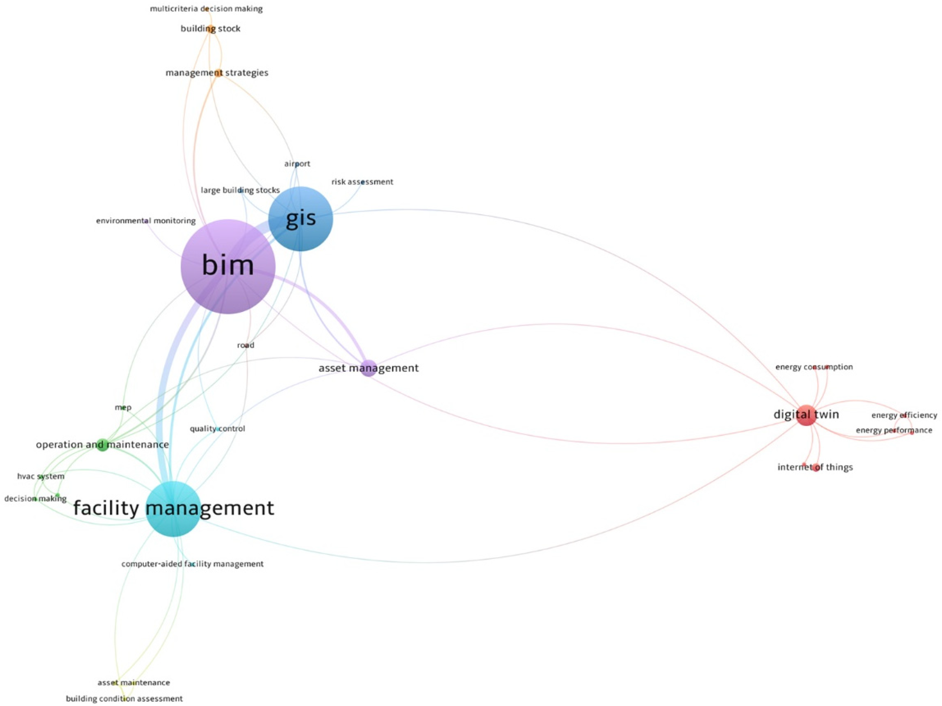
2.2. BIM–GIS Integrated Systems

Geospatial data in building planning and management play a very important role both because of their ability to integrate objects in a spatial context and because they simplify all those operations that manage a huge amount of information and data related to objects and to the territory in which these objects are located [35].
Geospatial data can contain information of the following types:
-
Spatial (geographic coordinates, primitive type: point, polyline, polygon);
-
Alphanumeric (descriptive type such as acquisition date, object type, thickness, temperature, etc.);
-
Temporal (dates of a particular activity, etc.).
Among geospatial data tools, Geographic Information Systems (GISs) play an important role, mainly due to their ability to perform spatial analysis and complex queries [36]. There are so many fields in which GISs can be successfully applied. However, we can say that the main fields of application are those in which it is essential to work with geo-referenced data, such as land use planning, transportation, resource management, utilities, security and the military, environment, archaeology, etc. Yildiz [37] reports an interesting application for calculating the number of wind turbines and their placement using an algorithm based on regulation, wind, and land cover. Maniatis et al. [38] present a fire risk estimation model that takes into account changes in land cover. Gacu et al. [39] report on the application of a GIS for the creation of a risk map indicating the building hazard index correlated with the structural information of each building. This result is extremely important for reducing the vulnerability of buildings in case of natural disaster events.
In all cases where a GIS has involved buildings, the main problem to be faced has been to manage the huge amount of data and information that a building brings with itself. The data are related to the structure, the facilities, the type of interventions over the years, and much more. In the management of such data, a significant contribution has been made by BIM–GIS integration, which has made up for the limited capacity of BIMs in spatial analysis and georeferencing of objects [40] and likewise has enabled GIS to integrate the amount of alphanumeric data from BIMs within it. Many research works have made the two systems interact together [41,42,43], investigating how to link and exchange information and data [44].
BIM–GIS integration generally involves the extraction and transformation of information required by each stakeholder involved in the specific project. GIS and BIM are similar because they both model spatial information (at different scales) and have common use cases, such as queries and location-based facility information management. Achieving integration requires effective interoperability between the two systems, which needs an appropriate platform [45]. In this regard, Moretti et al. [46] explore the combination of BIM and GIS and propose a GeoBIM approach intended to improve digital Asset Management (AM) by especially focusing on outdoor and indoor condition assessment of the built environment. More specifically, Moretti et al. present a GeoBIM model of the university Leonardo Campus of the Politecnico di Milano (Milan, Italy) by importing IFC models into a GIS environment in a 3D spatial data format by taking advantage of a specific commercial tool. Similarly, Sammartano et al. [47] worked on a 3D city model of Turin, Italy, with the aim of coming close to developing a digital twin of the city by taking advantage of a BIM–GIS integration through commercial tools.
Recently, FM research has been involving integrated BIM–GIS systems. FM is increasingly focused on finding solutions and tools to work at different scales, from component, room, or building scale to spatial, regional, or national [48]. The FM has identified the potential of GIS methodology and tools aimed at surveying, interpreting, and visualizing data from different perspectives to support facility manager decision making. In addition, the ability of GIS tools to perform analysis in the planning field or to simulate incidents and impacts that may occur during the life of a building facilitates the work of the facility manager [45,49]. By way of example, Kang and Hong [45] advance a proposal of a software architecture based on an effective BIM–GIS integration using IFC and CityGML schemas to specifically support FM. The research presented by Hu et al. [50] focuses instead on developing an advanced BIM-based O&M management framework for MEP (Mechanical Electrical Plumbing) systems by further including an algorithm intended to transfer BIM information into a GIS map.
Several research works have covered these integrations and developments in different fields of engineering: from public and private building management to infrastructure with the only purpose of better management and continuous monitoring. Vach et al. [51] present an integrated GIS–BIM–FM system for the management of public real estate in the city of Prague, Czech Republic. Vacca et al. [52] show the results of research about the integration between BIM and 3D GIS, applied to a housing project in the city of Cagliari, Italy. Mangia et al. [53] provide a comprehensive study, based on the analysis of the literature, concerning BIM–GIS integrated systems for managing large building stocks.
Other interesting applications of BIM–GIS integration systems refer to the management of infrastructure such as highways [54], airports [55], sewage systems [56], hydroelectric projects [57], or railways [58]. By way of example, the work of Cepa et al. [59] is centered on the development of a multi-scale BIM–GIS model, specifically intended to support the facility management (FM) of linear infrastructures (e.g., roads, highways, etc.) by making use of specific commercial tools to transfer IFC BIM models to a GIS platform.
In conclusion, the latest research trends concerning new tools and methodologies for FM of large and diffuse building stocks are oriented towards BIM–GIS effective integrations (also known as GeoBIM), even though several interoperability issues between the two systems need to be still fixed.
In the end, the summary map in Figure 1 provides a keyword co-occurrence network based on the literature review presented in this paper. The map consists of a distance-based network where the node size is directly proportional to the number of documents mentioning that keyword, whereas the space between nodes is representative of the relationship strength between the keywords. The map below therefore shows, on the one hand, how strong the relationship is between BIM and GIS that emerged from the literature review herein discussed and, on the other hand, how the research on BIM and GIS is also increasingly oriented to facility management services.

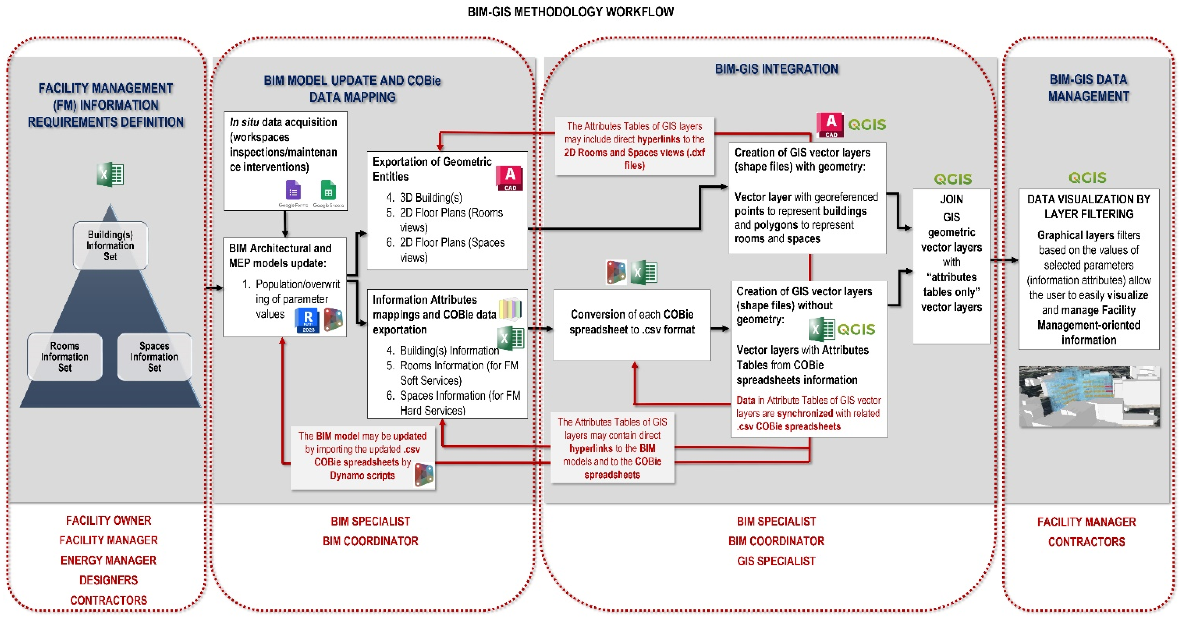
3. Methods and Tools

The development of a BIM–GIS methodological framework to support FM for building assets (e.g., aimed at easing the management of large public building stocks) is the main objective of the present work. This framework is not directed at transferring the whole information asset of BIM models into a GIS environment but rather it is aimed at implementing an effective bidirectional integration between the two informative systems, by properly relating them and allowing for an easy switch from one system database to the other. As shown in Figure 2, the proposed methodological framework is divided into five main tasks: FM information requirements definition; BIM model updating; COBie data mapping and management; BIM–GIS integration; BIM–GIS visualization and management.

3.1. Information Requirements Definition for FM

Any BIM-oriented process needs to start from an essential preliminary “cognitive phase” aimed at defining and organizing the information requirements, according to the specific purpose of the information model.
Optimizing FM-oriented processes for building stocks starts with gathering general information about the main use, construction year, construction permit details, cadastral data, retrofit interventions, etc., of the building(s). FM professionals collect this kind of general information asking for the support of the owner, the energy manager, and the designers. In the second phase, it is necessary to gather information to support two main categories of FM tasks: hard services and soft services. Hard services are tasks more strictly directed at managing physical aspects of facilities (gas, plumbing, HVAC systems, lighting, electrical, mechanical, fire safety systems, and building maintenance works), while soft services are tasks mostly aimed at making the building usage comfortable and safe (cleaning and custody services, waste management, catering, car parking services, maintenance works of outdoor areas, and workspace management). For gathering this second and more detailed information set, FM professionals need support not only from the owner, the energy manager, and the designers but also from the contractors involved in the management activities of the buildings. As shown in Figure 2, all the information and data gathered in the preliminary cognitive phase are then structured according to the following three categories, the building information set, the “Rooms” information set, and the “Spaces” information set.
In this perspective, except for general information regarding buildings of a diffused stock, the residual information asset oriented to FM has been distinguished into “Rooms” and “Spaces” information sets, assuming the former as “storage units” for soft service information and the latter for hard service information. This semantic distinction was also inspired by the differentiation between “Rooms” and “Spaces” inside the adopted BIM tool Autodesk Revit as “Rooms” are architectural components used to maintain information about occupied areas, whereas “Spaces” are exclusively used for the MEP (Mechanical Electrical Plumbing) disciplines [60]. Therefore, information requirements concerning the building use, occupancy, and conditions were included in the “Rooms” information set, whereas information requirements regarding the maintenance of MEP equipment were considered in the “Spaces” information set. As far as the building(s) information set is concerned, the adopted BIM authoring Revit stores this parameter category in the “Project Information” dialog box.

3.2. Building Information Model (BIM) Update

FM systems intended for widespread building stocks require a multi-scale approach, involving architectural and urban data assets at once. For this purpose, BIM is integrated into the proposed methodology with a crucial role in effectively storing and handling FM-related information referring to the building scale. As shown in Figure 2, architectural, structural, and MEP informative models are required to properly collect and structure encoded information related to all maintainable assets involved in both soft and hard FM services. It is widely reported in the literature how efficiently BIM can support FM activities such as workspace management, energy monitoring, maintenance of facility components and equipment, safety management, and so on [7]. BIM models are intended to support decision making across the whole life cycle of a building, from design to construction, use, maintenance, and demolition. BIM models are therefore conventionally implemented during the pre-construction phase, but they then need to be progressively and properly adapted for supporting the following phases, like construction and Operations and Maintenance (O&M). The proposed methodology considers a two-step update of the BIM model: a first update step consisting of a proper adaptation of the informative model to make it suitable to support FM and a second update level consisting instead of keeping the values of the involved parameters updated by making use of the proposed workflow in FM use cases.
The BIM model arrived from the design stage and provided an “as built” configuration with verified architectural features, dimensions, and position of components. It needs a Level of Development LOD500 in compliance with the American BIM protocol form [61]. The model must be equipped with encoded “Rooms” and “Spaces” items, which are strategic in the future perspective of collecting relevant information related to soft and hard service management. Starting from this configuration, the informative model has been modified to make it suitable to support an FM system. For this crucial activity, the facility manager needs to designate a BIM specialist and a BIM coordinator. To properly adapt a BIM model, originally conceived for supporting data storage and management at a design stage, to be subsequently adopted for assisting FM activities, first, accurate sets of shared parameters to hold useful information related to both soft and hard FM need to be created and associated to specific facility components to manage. Shared parameters to gather information related to workspace capacity, occupancy, state of use, and conditions are essential to support soft services in FM. Moreover, MEP components to maintain, equipped with specific shared parameters aimed at collecting information concerning scheduling and outcomes of preventive and predictive maintenance interventions, are fundamental to effectively support BIM-based FM hard services. Among all available commercial BIM-oriented software, Autodesk Revit 2023 is deemed the most suitable to achieve the goals of the present work, especially for its integration with the Dynamo add-on [62], as well as for the possibility of being integrated with the open-source “BIM Interoperability Tools” including a “COBie extension” toolset [63]. Dynamo is an open-source software platform, available as both integrated into Revit and a stand-alone tool (i.e., Dynamo Sandbox), for computational design and BIM [64], allowing through a friendly visual interface the construction of logic routines to smooth and automate workflows. Moreover, Dynamo is equipped with a player (called “Dynamo Player”) which further allows unskilled technicians to simply run Dynamo graphs in Revit without editing them if unauthorized.
As mentioned above, the BIM authoring tool Revit allows the users to make use of two distinct “spatial units”, i.e., the so-called “Rooms” and “Spaces”, both essential in a BIM-based FM framework. “Rooms” entities are more suitable to store information related to soft services (especially to workspace management), whereas “Spaces”, conceived to gather technical information related to MEP, are fitting to store supplementary data for computer-aiding hard FM. So, if the available pre-construction BIM model only provides “Rooms”, “Spaces” items also need to be placed in the model. As anticipated above, the “Project information”, “Rooms”, and “Spaces” Revit categories then need to be equipped with new shared parameters to store essential information about the building in supporting soft and hard FM services. To automate this process, after arranging in an Excel spreadsheet the new parameters with encoded names and types, a specific Dynamo script enables automatically writing a “.txt” file including the required three “Groups” of shared parameters and then directly associating them to the “Project information”, “Rooms”, and “Spaces” categories. Making use of this Dynamo script, all information models of the asset to be managed can be automatically upgraded with the new sets of shared parameters by further preventing the risk of forgetting any parameters or making some errors in setting them up. Once the pre-existing pre-construction BIM model is properly adapted to make it suitable for assisting FM operations (first update step), the informative model could be easily updated (second step) by executing specific Dynamo scripts enabling values of shared parameters to be correctly populated or overwritten in compliance with their data types (e.g., numerical, textual, Boolean, etc.). Dynamo scripts also allow the “constrained parameters” to be populated or updated to calculate, whose values depend on other parameters or specific conditions. It is also worth underlining that Dynamo scripts allow the users to read and extract data from external “.csv” or “.xlsx” files, as well as from Google Sheets in cloud-stored data by making use of a specific open-source Dynamo package called “BIMOne”. As it will be more clearly shown and explained through the operational applications to real case studies, the proposed methodology considers the use of tailored Google Forms to collect all required information during in situ scheduled inspections of workspaces and systems. Since Google Forms can be linked to Google Sheets to store “Form Responses” once submitted by the designated technician, Dynamo scrips enhanced with BIMOne components (see Figure 3) enable “Form Responses” data to be automatically extracted and the respective parameter values to be properly populated or overwritten in the BIM model (see Figure 4). Moreover, Google Sheets keeps in memory all history data from Form Responses deriving from in situ workspace inspections and maintenance interventions, thus supplying a chronological database of all in situ-acquired data.

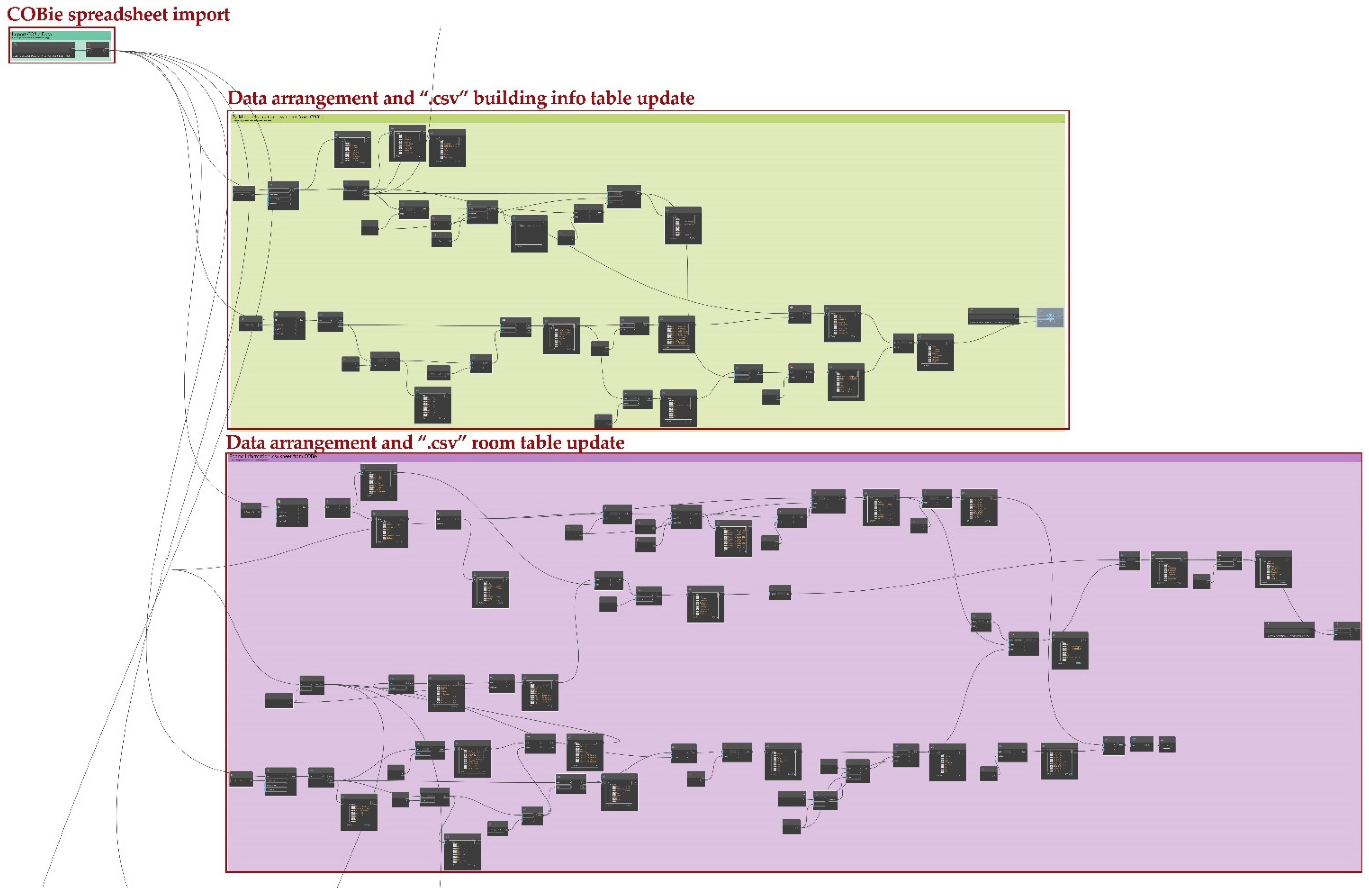
3.3. COBie Data Mapping and Management

As anticipated in the present work, the COBie schema has been chosen as the main data exchange vehicle between BIM and GIS environments. COBie relies on a non-proprietary format, and it was specifically implemented for managing information related to the maintainable assets of facilities. The National BIM Standard-United States® (NBIMS-67 US™) COBie is indeed a non-graphic data format and process standard supporting BIM-oriented processes aimed at managing facility assets [64]. One COBie file shall be provided for each facility as a subset of a BIM model [65]. In design and construction projects, the ultimate purpose of COBie is to deliver information about assets in a facility to the next owner/manager at the end of a phase in the project lifecycle, but it can also be applied to intermediate handovers (i.e., the so-called “data drops”) between consultants during the design and construction process [64]. A COBie deliverable can be represented in a digital spreadsheet format, which is typically structured into multiple tables (or worksheets). Each table includes a standardized set of data fields, with required ones that may be prerequisites to using other tables [64]. The aforementioned “COBie extension” add-on, part of “BIM Interoperability Tools” for Revit, allows users to set up BIM models, to properly populate COBie parameters, and to export data to a COBie-compliant spreadsheet [63]. It relies on specific shared parameters to hold the COBie data in the model, which can be customized using the “Parameter Mapping” feature, included in the “Setup Project” dialog box. The “COBie extension” also provides a “Contacts” dialog, which allows users to add, edit, or delete COBie contacts [63]. The “Setup Project” dialog box is the most crucial of the “COBie extension” tools as it allows users to choose default values for COBie fields and generate the required COBie parameters in the Revit model, as well as to import schedules and other necessary contents [63].
The “Setup Project” button opens a new window incorporating several dialog boxes, which enables users to define COBie settings for spaces, types, components, systems, attributes, coordinates, and schedules. Among all the settings just mentioned, the “Spaces” dialog box permits to configure whether Revit elements should be referred to the room or the space in which they are located. The “Attributes” setting window (in Figure 5) gives the users the fundamental ability to select additional (with respect to COBie standard parameters) “Type” and/or “Instance Parameters” from Revit families to be exported to the “Attribute worksheet” in the COBie spreadsheet [63]. The use of this additional feature is strongly encouraged in the proposed methodology to include within the COBie deliverable some supplementary information (i.e., not included yet in the COBie standard data asset) deemed relevant for FM, stored in tailored shared parameters. Once all COBie standard and supplementary customized parameters are populated through the “Update” dialog box, the “Create Spreadsheet” feature allows the users to properly export the previously set up and selected data to a COBie-compliant spreadsheet as a Microsoft Excel document [63].
At this stage of the herein proposed methodology, the skills of the BIM coordinator are needed. He/she has to make use of specific Dynamo visual scripts [62] for properly automatically arranging data from “Facility” (including “Project Information” parameters), “Space”, and “Attribute” COBie sheets before exporting the related data to “.csv” tables (see Figure 6). That information needs to be reorganized in new specific tables. In fact, the “Attribute” COBie sheet holds together all additional (i.e., which are not considered among COBie standard fields) tailored parameters selected for exportation, mined from any Revit categories, whereas the “Space” sheet stores together COBie-required data deriving from both “Spaces” and “Rooms” Revit entities. In the end, the Dynamo visual programming scripts in Figure 6 also allow the automation of a proper transcription of the selected data from the COBie spreadsheets into “.csv” tables intended for being imported and integrated into the GIS environment.

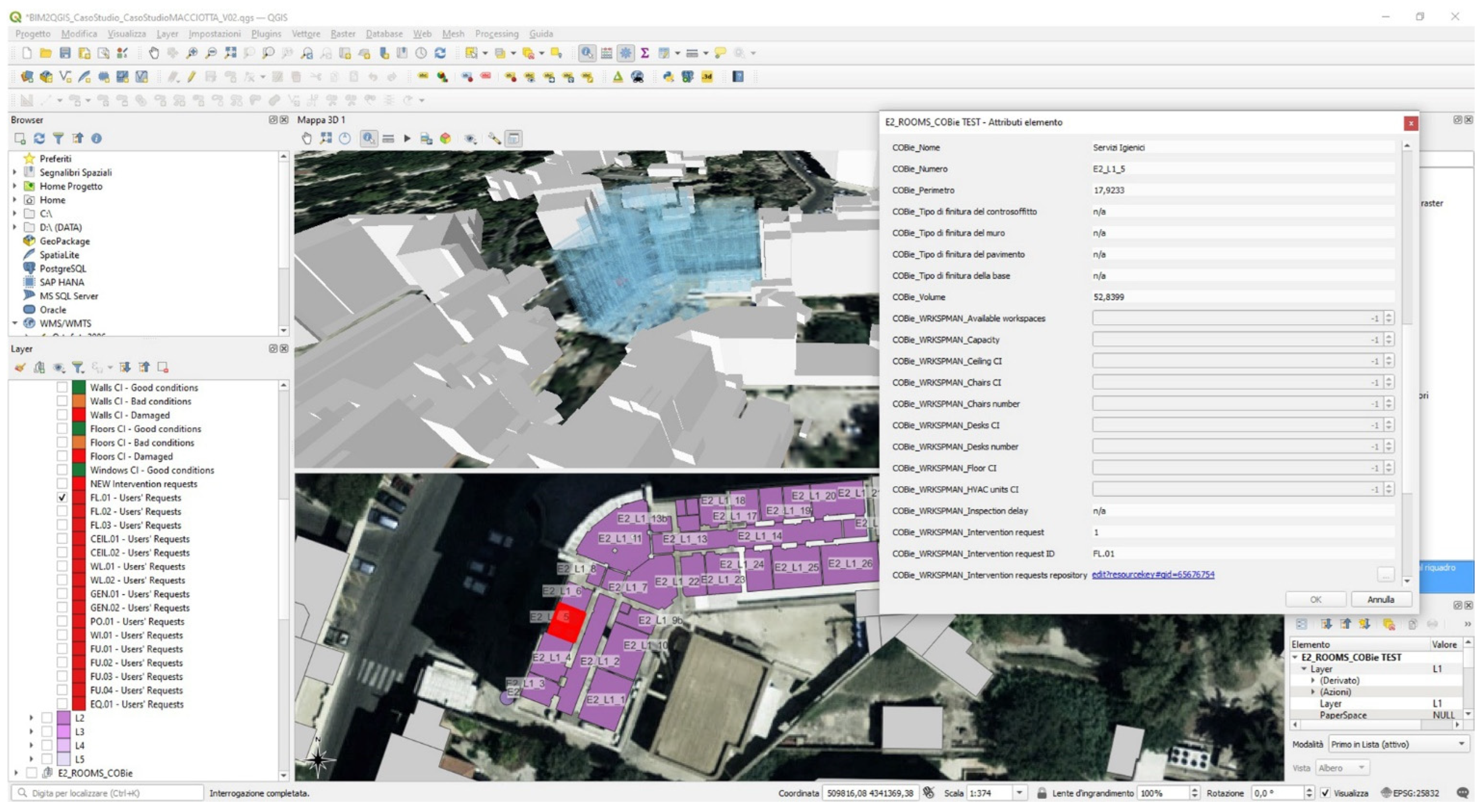
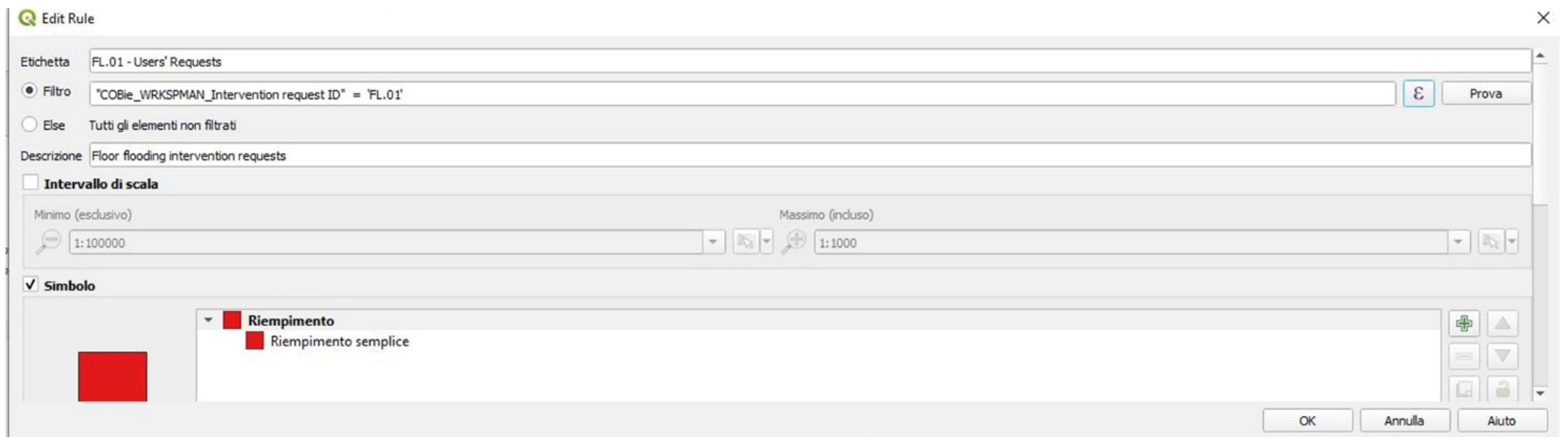
3.4. BIM–GIS Integration

As anticipated above, importing integral BIM models into a GIS environment is not among the purposes of the present work. For this reason, this stage of the methodology requires a closed and constant activity between the BIM coordinator and the GIS specialist. Indeed, some existing commercial tools already enable IFC geometry and information to be imported and read through CityGML (City Geographic Markup Language) data models [52,66,67,68]. The herein presented alternative framework has been implemented by integrating the two informative systems by taking advantage of the COBie exchange schema, as well as by properly selecting geometrical entities and essential information to be synchronized with the GIS-based environment (with QGIS 3.28 open-source tool [69]).
The open tool QGIS enabled the creation of georeferenced 2D and 3D maps, based on overlapping raster and vector layers (all available from open databases), including the following:
  • DTM (Digital Terrain Model) raster layer adopted as DEM (Digital Elevation Model) source for the terrain elevation (freely available for Sardinia Italian region [70]);
  • Orthophoto of the area (GSD 20 cm, freely available for Sardinia Italian region [71]);
  • Vector shape file of volumetric units of buildings from a geo-topographic database 1:2000 (freely available for Sardinia Italian region [72]).
The aforementioned 2D and 3D queryable maps provide a suitable GIS-based environment to be efficiently integrated and linked with external geometric entities and respective information extracted from BIM models of a widespread building stock (e.g., such a university stock) to be managed.
It is worth highlighting that the proposed BIM–GIS integration required a clear distinction between geometric items and respective semantic attributes to be exported from BIM models for being transferred to the GIS environment. This clear separation is made necessary by the need to export geometric items through the “.dxf” format, which is suitable for being converted into GIS shape files but which, at the same time, involves the loss of the information associated with the exported objects. Therefore, the COBie standard format has been adopted as the main vehicle for semantic data exchange, by taking advantage of the “COBie extension” included in “BIM Interoperability Tools” for Revit to properly arrange and export some selected essential information through “.xlsx” and “.csv” formats. In particular, it was noticed that “.csv” files are more appropriate than “.xlsx” for being assumed as a data source for GIS shape files, only incorporating attribute tables (see Figure 2). It is also worth highlighting that once a geometryless GIS vector layer is created from a “.csv” data source, information included in the attribute table of the GIS layer will stay constantly synchronized with the respective data source. As shown in the workflow in Figure 2, semantic alphanumeric information needs to be properly linked to the respective geometric objects in the GIS environment, without losing synchronization with the data source files. This operation is made possible by the QGIS “Joins” layer tab [69], allowing the user to associate geometric features of the current layer (called “Target layer”) to alphanumeric attributes from a geometryless layer (i.e., the “Join layer”) including a COBie table. The “join” operation is based on an attribute (called “Join field”) that is shared by the layers [69]. In this context, since the BIM coding system uniquely identifies each item, the related attribute could provide a suitable “Join field” to properly associate semantic information to the respective geometric entities in the proposed BIM–GIS integrated system. As far as it concerns geometric entities, to meet the information requirements previously defined in Section 3.1 paragraph, rooms and spaces items have been considered essential to be exported as “polygons” to “.dxf” from BIM models of facilities to manage and imported into the GIS-based 2D–3D map. Moreover, vector layers with georeferenced points were included in the proposed BIM–GIS integrated framework to represent the buildings to manage and allocate into the related attribute tables the most relevant general information. To be able to distinguish more easily in the 3D GIS map the buildings to be managed from those of the urban context (i.e., the unit volumes of geo-topographic databases modeled as simple extruded polygons), three-dimensional representations of the considered buildings can be exported to “.obj” from BIM models and made visible through “3D View Properties” of georeferenced points in QGIS.
A further purpose of the proposed methodological approach consists of ensuring a bidirectional integration between BIM and GIS environments. To achieve this goal, building attribute tables must also include URL fields to hold direct hyperlinks to BIM models, COBie spreadsheets, CAD drawings, or any other additional documentation deemed crucial to support the facility manager’s work (as shown in Figure 2). Moreover, proper Dynamo scripts (see Figures S4 and S5 in Supplementary Materials) allow the BIM model parameters to be automatically updated whenever information in “.csv” files is updated from the GIS platform.

3.5. BIM–GIS Data Visualization and Management

The presented workflow leads to the development of a GeoBIM model, mainly manageable within QGIS by the facility manager but constantly synchronized with BIM data sources. Once all relevant spatial, architectural geometric, and semantic information related to FM assets (i.e., building general information, rooms and spaces information, and equipment information) are made available into the QGIS interactive 2D–3D map by keeping data synchronization with external data sources, filter rules can be effectively set up. Arranging proper filter options allows users to easily display, through proper color scales, relevant features for FM such as workspace occupancy rates and conservation and functionality status of spaces, systems, and equipment, etc.
The present workflow thus proposes the use of a “Rule-based renderer” option available for both 2D and 3D “Symbology properties” of layers [69] to ease the visualization and management of information by focusing on FM needs. Rule-based render options allow the discrimination of features of a layer according to their attributes by assigning them specific rendering settings. Filter rules can be set up by taking advantage of a powerful SQL (Structured Query Language)-based “Query builder” dialog. In this regard, it is worth highlighting the importance of setting up equally named filters, based on the same rules, in both 2D and 3D display properties of layers, to ensure a perfect correspondence between 2D and 3D visualization of the GIS map (see Figure 7). Unfortunately, QGIS does not enable 2D and 3D render filters that are based on the same rules to be activated concurrently. Users must therefore pay attention to activate 2D and 3D render options properly.

4. Experimental Phase

The present section of the paper is aimed at validating the methodology shown in Section 3 by simulating two different operational case uses, both concerning workspace management services, addressed to a real building, which is part of the large stock owned by the University of Cagliari.

4.1. The Case Study: The Former Macciotta Pediatric Hospital

The former Macciotta hospital (in Figure 8), owned by the University of Cagliari and currently the object of renovation and conversion activities in terms of its final use, housed a pediatric clinic for more than half a century, representing an important case of healthcare building made in the decade between 1950 and 1960.
It consists of two four-story parallelepiped volumes connected by a central building block. The two volumes, symmetrically arranged with respect to the main entrance, have different lengths but a similar construction technique based on traditional brick and local stone masonry and concrete floors. The elevations are characterized by essential and repetitive openings behind which the double line of hospital rooms separated by a central corridor is clearly visible. The central block of the building, which houses the entrance lobby and the monumental staircase, is marked by a completely different construction technique and design. The reinforced concrete frame alternates with full-height openings made of very thin iron-window profiles. In this building body, the floors are made of concrete. The complex is currently at the center of a conservation, rehabilitation, and reuse intervention that is part of the larger program of reorganization of Cagliari’s historic urban university campus. In fact, contemporary clinical practices have made the original configuration of containers designed for medicine in the mid-20th century progressively inefficient, and they have been progressively transferred to the new suburban university center. The empty and large medical building will be converted into a system of study rooms, small rooms for research work and discussion, and technical administrative offices.

4.2. Applications of the Proposed BIM–GIS Workflow to Workspace Management Case Studies

Given the importance of efficiently managing spaces with varied intended uses in public buildings, the present work was focused on testing the proposed BIM–GIS methodology on two different operational use cases both related to workspace management services.
More specifically, the following use cases have been dealt with:
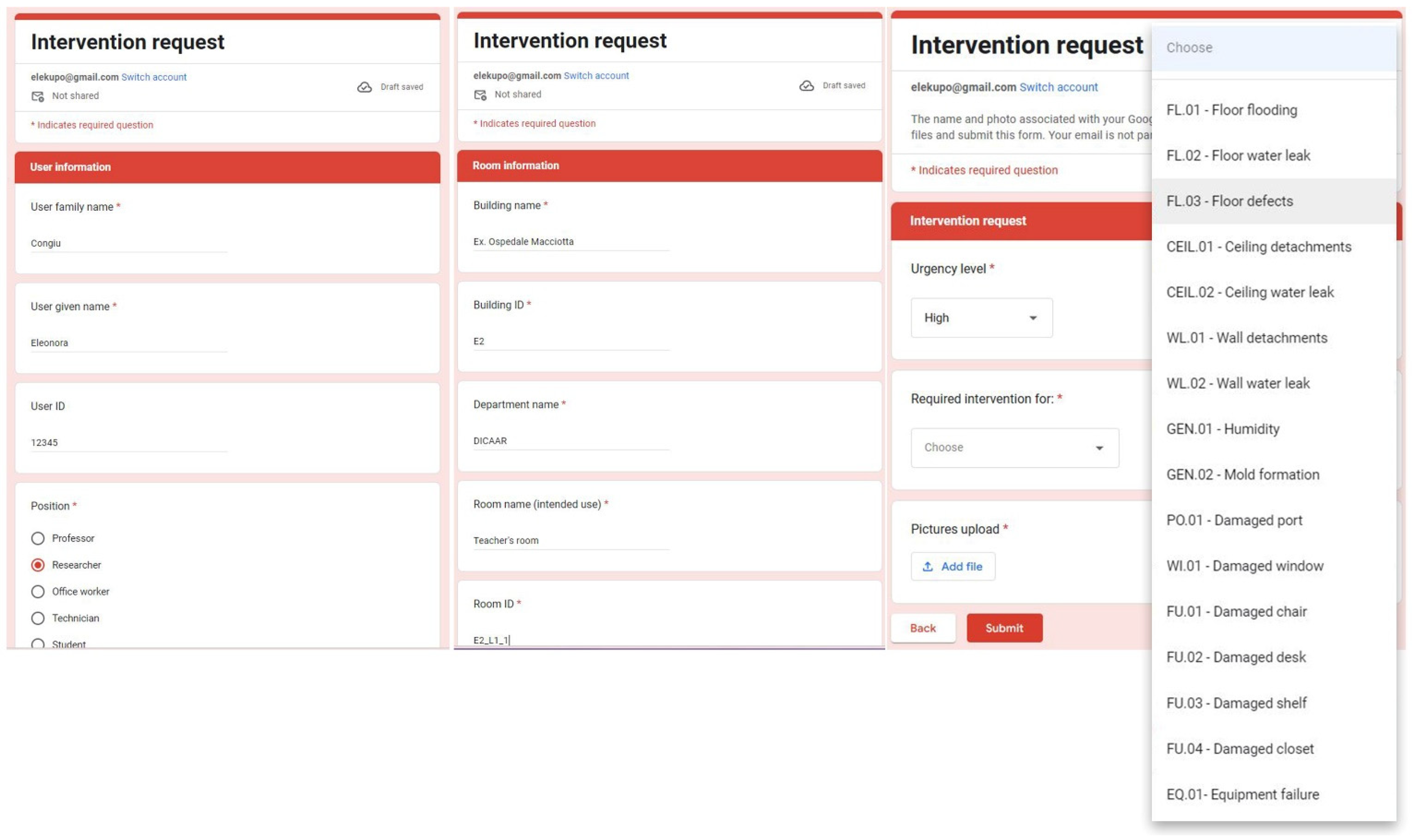
  • An urgent intervention request sent by a generic user (e.g., a student, a professor, a researcher, or an office worker) to solve critical issues that make a workspace uncomfortable and/or unusable (e.g., floor flooding, water leaks, humidity and/or mold formation, equipment failures, etc.);
  • Scheduled mandatory inspections carried out by a qualified physician (or by another responsible person designated by the facility manager) to regularly assess workspaces healthiness, compliance with safety standards, ergonomics, and functionality.
To effectively validate the proposed BIM/GIS-based methodology by simulating the operational use cases mentioned above, a BIM model of the considered case study described in the previous section, deriving from the design stage, has been properly adapted to make it suitable to support an FM system.
The BIM model (Figure 9) of the former Macciotta hospital, created for supporting the design stage related to the aforementioned retrofitting and reuse scheduled interventions, provided an “as built” model, referable to a Level of Development LOD500 in compliance with the American BIM protocol form [61] with verified architectural features, dimensions, and position of components. The model was originally equipped with encoded “Rooms”, but it was also integrated by placing “Spaces” items, in the future perspective of collecting relevant information related to maintainable components (e.g., system elements and equipment). To ensure a perfect correspondence between “Rooms” and “Spaces”, the latter names have been properly encoded in accordance with the following rule:
<Room tag>.SPACE
where the “Room tag” encoding was, in turn, based on the following rule:
<Building ID>_<Floor ID>_<Room number>.
As stated above, the present work mainly focuses on workspace management services. To avoid the risk of over-modeling, it was decided to not model rooms’ furniture or equipment, but rather to enrich “Rooms” items with specific shared parameters deemed essential to gathering exhaustive information about room conditions, state of use, healthiness, and functionality. It is worth underlining that the choice of resorting to shared parameters brings the great advantage of enabling the set of parameters to be reused in multiple projects since shared parameters are stored in an independent file. Therefore, in the perspective of making the proposed methodology truly effective in supporting FM of a large building stock (e.g., a university campus), adding the same set of shared parameters to all BIM models of the large asset to be managed could be extremely beneficial indeed.
To make additional shared parameters easily identifiable, the ones related to workspace management have been properly encoded in accordance with the following rule:
WRKSPMAN_<Parameter semantic name>
by therefore assuming “WRKSPMAN_” as a prefix for easily recognizing these parameters.
In this regard, in Table 1, all considered shared parameters added for supporting workspace management tasks are listed. It can be noticed that three parameters among all listed above (Table 1) refer to room occupancy, five parameters store instead quantitative information about rooms’ equipment and furniture, whereas a further eight parameters have been set up to collect integer values from 0 to 5 referring to a condition indicator (CI) for walls, floors, ceilings, windows, HVAC (Heating Ventilation Air-Conditioning) units, furniture, and equipment. Furthermore, other nine parameters have been added to collect relevant information concerning scheduled inspections dates and delays, as well as users’ interventions requests, including some URL input values to enable an easy access to intervention requests, inspections reports, and picture repositories. Some other distinctions among the considered shared parameters have to be made:
  • Most of the parameters have been conceived to be populated and updated with values acquired during user-required or scheduled inspections (e.g., CI parameters and quantitative parameters related to equipment and furniture);
  • The values of some crucial parameters are constrained by some specific conditions and/or mathematical functions. These parameters therefore should not be manually edited, but rather they have to be automatically overwritten by executing specific Dynamo scripts (see Figures S2 and S3 in Supplementary Materials) that take into account constraint conditions and functions (e.g., room available workspace parameter, inspection delay, and new intervention request parameters).
As far as parameter types are concerned, those (in Table 1) collecting quantitative information about rooms’ furniture and equipment, as well as the ones storing CI measures, require “Integer” input. Alphanumeric information is assumed to be stored in “Text”-type parameters, also including date and time information as Revit parameters do not support date-type data. Luckily date and time data can be easily managed by specific Dynamo components, of which an application case will be shown in the next section. Moreover, some “Yes/No” parameters have been introduced to provide some relevant alerts (e.g., about scheduled inspections delays or new intervention requests by users).
In the end, it can be noted that most parameters have been set up to also be synchronized with the GIS-based platform since keeping the two informative systems (i.e., BIM and GIS) well-distinct is one of the main goals of this work.

4.3. Use Case 1: Intervention Request from Users

The present section focuses on illustrating a first operational use case of workspace management to validate the effectiveness of the proposed BIM/GIS-based methodology. The workflow in Figure 10 shows schematically all steps, tasks, and people in charge, which could be involved once an urgent intervention request is submitted by a user.

4.3.1. Intervention Request by Google Form

As shown in Figure 10, it was assumed that any potential user (i.e., a university member) could present an intervention request through a specific Google Form, an example of which is provided in Figure 11. The proposed Google Form sample is subdivided into the following four different sections: 1—request date; 2—user’s information; 3—room information; 4—intervention request details. Keeping track of request dates is fundamental to efficiently monitoring response times of the FM system to constantly assess its efficiency. The second section simply stores information about the applicant. The required information in the third section of the form sample is addressed to uniquely identify the room affected by the issue object of the intervention request. The last section of the proposed Google Form sample is intended to gather relevant but concise information about the intervention request. The user can assign an urgency level to their request, based on their personal perception, but the form also requires uploading compulsorily at least a picture of the problem reported, to allow the facility manager to assign an objective urgency level. The last section of the form further provides a dropdown menu enabling the user to select an option among several common intervention requests with assigned IDs.
Once a user submits the form, responses automatically fill the last non-empty row in a specific Google Sheet, where it will be kept track of all users’ requests (see Figure 12).

4.3.2. Data Storage: BIM and GIS Models Update through COBie

As anticipated in Section 3, a specific Dynamo script, enhanced with BIMOne components, has been implemented to enable a BIM practitioner to extract data easily and automatically from a Google Sheet and properly populate (or update) the related parameter values in the BIM model. Figure 13 shows how a Dynamo script could be executed through the Dynamo player (integrated with Revit) without opening the code and thus preventing the risk of editing it wrongly.
Once the BIM specialist or coordinator in charge runs the Dynamo code, the Yes/No parameter “WRKSPMAN_Intervention request” will be activated (i.e., set to Yes) for each “Room” a new intervention request (in the last seven days) is detected in the Google Sheet repository. At the same time, the parameter “WRKSPMAN_Ticket open” will be also set to Yes, whereas the parameter “WRKSPMAN_Intervention request ID” will be properly populated with the related requests IDs (see Figure 13). The parameter “WRKSPMAN_Ticket open” plays a crucial role in the described workflow as it will be kept activated until the issue, the object of the user request, is faced. Moreover, the request ID parameter will keep its value until the request ticket stays open. In fact, only once the open ticket parameter is set to No will the corresponding request ID be deleted automatically by the Dynamo algorithm. In order for the proposed system to work efficiently, the aforementioned Dynamo script must be executed every seven days, or, alternatively, a different time span for detecting new intervention requests must be set up in the code.
Once the Building Information Model is properly updated (Figure 14), the related COBie spreadsheet must also be arranged and exported, by making use of the aforementioned “COBie extension add-on” for Revit. As previously shown in Section 3.3, before exporting the COBie spreadsheet, the additional shared parameters added to the BIM model and set up for being also exported to the GIS system (which are identified in Table 1) need to be selected to be included in the COBie “Attribute” sheet (see Figure 15). After having set up and updated the COBie parameters, a COBie-compliant deliverable can be created as a Microsoft Excel file (or updated if the file was already appended). Then, as previously explained in the methodological section, by simply executing a specific Dynamo script (already described in Section 3.3), selected data from the “Space” and “Attribute” COBie worksheets overwrite the “.csv” table integrated into the GIS environment as the “Rooms” attribute table. Whenever the “.csv” is updated, the related information is also automatically updated in the GIS platform.
As far as the involved information set is concerned, “Rooms” attributes deemed crucial in supporting workspace management tasks have been shared between BIM and GIS databases including the following: room name (referring to its intended use), room encoded tag, room area, room usable height, room volume, and the tailored shared parameters (see Table 1) added for better supporting workspace management of a university building (like the considered case study).

4.3.3. Data Visualization and Management Based on Graphical Alerts

Once the BIM and GIS databases are properly updated, the facility manager could easily see whether any room was affected by a new user intervention request in the last seven days, by simply activating the specific filter “NEW Intervention requests” (among render options in Figure 16), made available for both the 2D and the 3D GIS map. Moreover, to support the facility manager’s work, specific 2D and 3D display filters based on values of the attribute “COBie_WRKSPMAN_Intervention request ID” have been set up to make the identification by type of new or still unsolved issues easier.
By way of example, in Figure 16, the activation of an alert for new (or still unsolved) user intervention requests for a floor flooding issue (intervention ID: FL.01) in a toilet, highlighted in red, is shown concurrently in both the 2D and 3D map views. Note that Figure 17 shows instead how the rendering rule was configured properly.
Similarly, in Figure 18, two teachers’ rooms, still highlighted in red, report new (or still open) warnings for a damaged desk to be replaced (intervention ID: FU.02).
It can be noted that in both cases (shown in Figure 16 and Figure 18), rooms are provided with a peculiar attribute, the “COBie_WRKSPMAN_Intervention requests repository”, which contains a clickable hyperlink to directly access the users’ request repository, thus enabling the facility manager to inspect all requests details and the related picture gallery.
It is worth underlining how the concurrent use of 2D and 3D views turned out to be extremely difficult for the following reasons: first, because users must pay attention to manually activate 2D and 3D display filters based on the same rules; moreover, the 3D view is affected by some annoying display and selection bugs, which make it difficult to correctly query the 3D map.
In light of the above issues, even though the 3D visualization could be advantageous to allow the facility manager to more easily identify which levels of a building and which buildings within a widespread asset are affected by some critical issues, the 2D map view turned out to be more easily accessible, queryable, and manageable.

4.3.4. Issue Solution and Informative Systems Update

After having taken note of the latest user requests to manage, the facility manager in charge can assign an objective urgency level to each request, based on pictures compulsorily uploaded by the applicant from the university, in order to schedule the required interventions accurately.
Once the facility manager receives a notice about the solution to the problem, certified by a report uploaded by the designated specialist, the parameter “WRKSPMAN_Ticket open” can be set to No. Then, updating the BIM model by executing a Dynamo code, all alerts for intervention requests that have been solved will be turned off in the herein presented BIM–GIS integrated system. The proposed workflow will work efficiently provided that every time one of the two involved informative systems (the BIM model or the GIS-based interactive map) is updated, the other system must be also kept updated by properly executing the specific Dynamo scripts that ensure an effective bidirectional connection between the coupled systems.

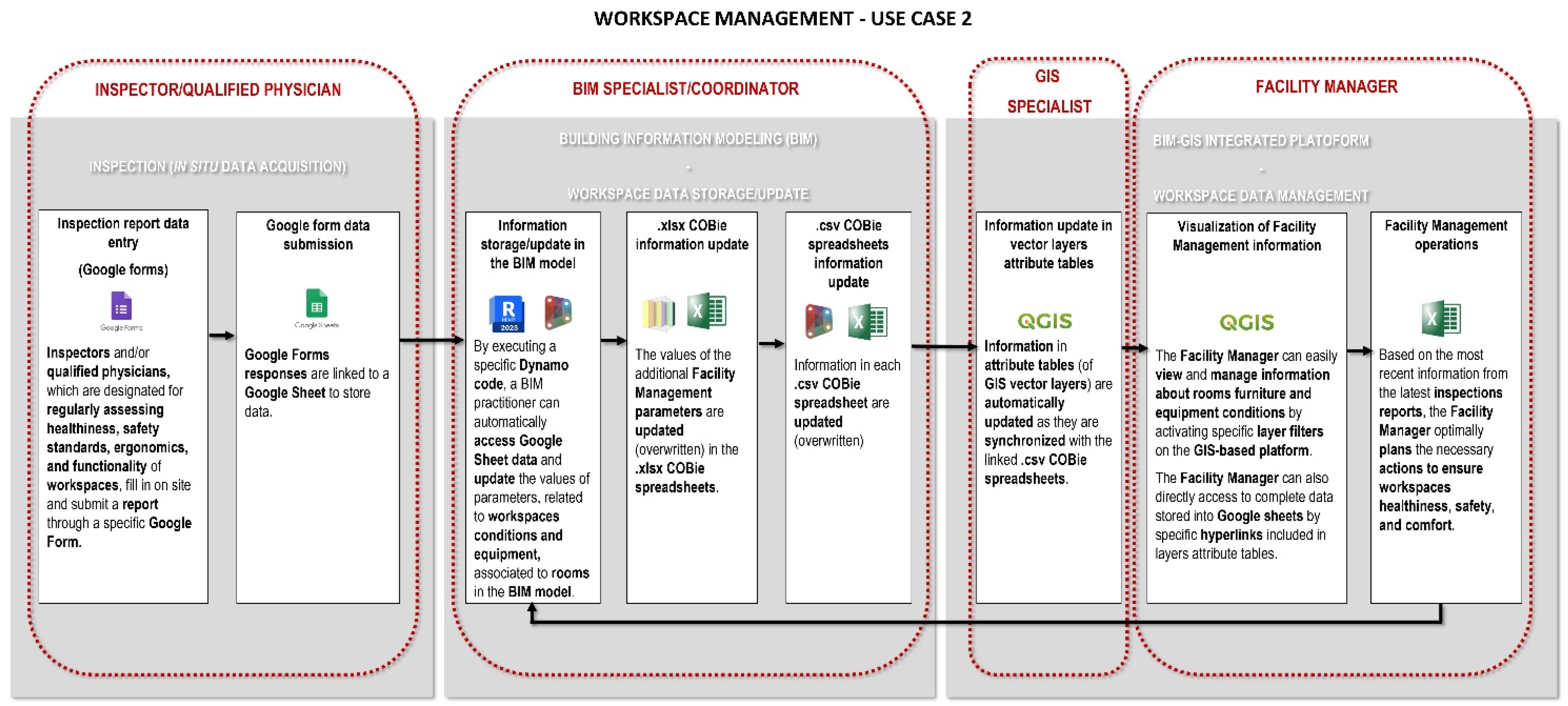
4.4. Use Case 2: Scheduled Annual Inspections by a Qualified Physician

The present section describes a potential use case of the proposed methodology aimed at proving its effectiveness in supporting efficient management of scheduled mandatory inspections to ensure healthiness, compliance with safety standards, ergonomics, and functionality of workspaces. In this regard, all steps, tasks, and people in charge involved in the process are schematically represented in the flowchart below (in Figure 19).

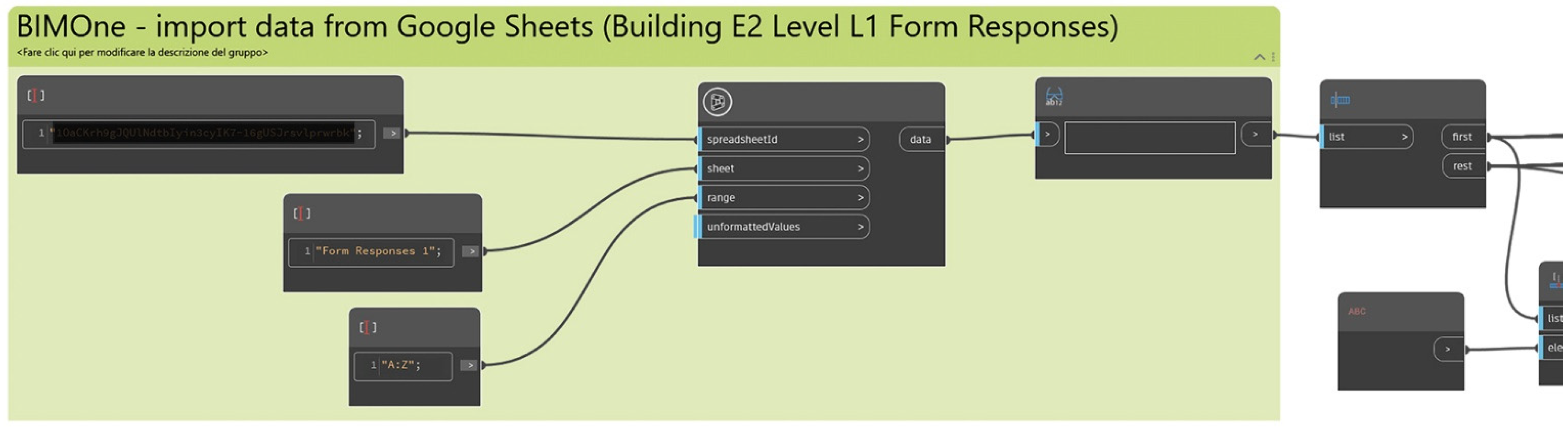
4.4.1. In Situ Data Acquisition by Google Form

By way of example, the present section reports a Google Form sample (see Figure 20) for supporting in situ data acquisition to be accomplished by a qualified physician or by another designated inspector through mandatory scheduled inspections of workspaces.
The proposed sample is structured into three distinct sections: 1—general information (concerning the inspector’s personal information and the building identification); 2—room identification (i.e., room ID, intended use, and capacity); 3—room state of use and condition assessment.
As shown in Figure 20, the proposed Google Form example is specifically conceived for each single level of the considered building to allow an easy identification of the room to be inspected on site thanks to a 2D floor map with the encoded room tags. It is also worth noting that the condition assessment of room walls, floors, ceilings, window fixtures, equipment, and furniture is made handy by making use of “linear scale questions” based on a scale range between 0 (corresponding to a damaged component to be urgently repaired or replaced) and 5 (corresponding to a very good status). At the end of the form, a mandatory question for uploading from 1 to 10 pictures is also supplied.
Analogously to use case 1, once the qualified physician/inspector submits the form, responses automatically fill the last non-empty row in a specific Google Sheet, where all inspection reports will be kept track of.

4.4.2. Data Storage: BIM and GIS Models Update through COBie

As previously shown in Section 4.3.2, once a Google Form is submitted, the BIM model is updated by simply executing a specific Dynamo code, which enables the data collected in a specific Google Sheet during the latest inspection to be directly extracted and the values of the related parameters (e.g., the parameters intended for storing Condition Indexes associated to rooms, the URL parameter including the direct link to room pictures from surveys, etc.) to be properly populated (or overwritten). Moreover, when the Dynamo code is executed, the parameter “WRKSPMAN_Inspection delay” is set to “Yes” if any delay in scheduled inspections is detected. Once the COBie deliverable is updated by making use of the “COBie extension add-on” for Revit as before, the “.csv” table integrated into the GIS environment as “Rooms” attribute table is properly overwritten by simply executing the specific Dynamo script described in Section 3.3.

4.4.3. Data Visualization and Management Based on Graphical Alerts

Consistent with the proposed methodological workflow, 2D and 3D rule-based render filters have been specifically set up based on values of peculiar attributes, as main data visualization and management tools. To avoid redundancy, since it has been already described in detail in Section 3.5 and Section 4.3.3 how 2D and 3D display filters for vector layers can be set up and work in the proposed BIM–GIS integrated system, it is simply worth highlighting here that three specific rules have been configured for each category (see Figure 21) to allow the facility manager to intuitively detect good conditions (displayed in green), bad conditions (displayed in orange), and damaged (displayed in red) room components (e.g., walls, floors, ceilings, and window fixtures), equipment (e.g., computer displays, printers, lighting, HVAC units, etc.), and furniture (e.g., desks, chairs, shelves, etc.).
Furthermore, as shown in Figure 21, a specific filter, based on the value of the Yes/No parameter “WRKSPMAN_Inspection delay”, allows the facility manager to effortlessly detect any possible delay in scheduled inspections.

4.4.4. Issue Solution and Informative Systems Update

The concurrent display (in both 2D and 3D map views) of which rooms in a building and which buildings in a widespread building stock are affected by any kind of issues, enabled by the filter-based visualization system previously shown, can support the facility manager in more efficiently scheduling urgent surveys, interventions, and restock orders to keep workspaces healthy, safe, comfortable, and functional.
Moreover, thanks to a direct hyperlink made available among the room attributes in the proposed BIM–GIS integrated system, the facility manager can effortlessly access cloud storage for pictures uploaded during the last survey pertaining to each room.
In the end, provided that both coupled informative databases (i.e., BIM and GIS) are constantly and properly kept updated, the proposed system can actually support the facility manager in more efficiently planning mandatory inspections and managing the related information by easily accessing reports and picture repositories.

5. Discussion

The experimental phase allows the authors to highlight the strengths and weaknesses of the methodological framework developed. One of the strengths of it focuses on the prevalent use of open-source tools. It is worth highlighting how this aspect is strictly bound with the important issues of interoperability, customization, verifiability, optimization, and low costs. As mentioned in the literature review section of this paper, the literature concerning BIM–GIS integration has mainly proposed the use of closed and very expensive proprietary software to manage both geographic and building information sets. The proposed methodology instead shows a novel contribution because it aims to involve open-source tools and non-proprietary data exchange formats. Apart from Autodesk Revit (v. 2023), which is a proprietary program used to develop the informative model of a building, the proposed framework involves Dynamo, an open-source visual programming program adopted to carry out specific operations automatically; QGIS (v. 3.28), an open-source program that allows users to manage geospatial information; and COBie [73] as the main information vehicle between the BIM and GIS databases. We have chosen COBie because in the field of FM, it is recognized as the international standard for interchange of non-graphical information model data. Currently, it shows widespread use, and, in some countries, it has become mandatory. However, some critical issues inherent in the use of COBie have been found. As mentioned above, a COBie deliverable can be represented in a digital spreadsheet format, which is typically structured into multiple tables with standardized sets of data fields. The aforementioned “COBie extension” add-on, part of “BIM Interoperability Tools” for Revit, allows users to set up BIM models, to properly populate COBie parameters, and export data to a COBie-compliant spreadsheet. However, as COBie does not hold in the standard parameter sets much supplementary information deemed relevant for FM, it is necessary to define tailored shared parameters in order to store additional data and information. Unfortunately, as COBie holds together (in the “Attribute” sheet) all supplementary parameters, it is necessary to reorganize them, making use of specific Dynamo scrips, in new tables before exporting the related data to “.csv” tables.
Another strength which also represents the novelty of the proposed methodology is the simultaneous use of BIM and GIS databases. As mentioned above, many research works cope with the BIM–GIS integration focusing on the integral transposition of the BIM data set to the GIS platform [52,66,67,68]. Our work led instead to the development of a multiscale approach based on a bidirectional integration between the two informative systems by properly relating them and allowing for an easy switch from one system database to the other.
Despite the benefits that BIM offers to the proposed workflow, it is worth highlighting its potential issues. Currently, the informative model is mandatory only for public interventions: new building construction or refurbishment actions on the existing buildings. In all the other cases, the informative model is a volunteer choice of who really knows the great benefit of the BIM methodology to manage the specific building process. For all of these reasons, the informative model of a building is not always available during the O&M phase. In other cases, it is developed to support the design or the construction phase with an information and data set that is not compliant with the needs of the O&M phase. In these cases, hard preliminary work may be needed to adapt and integrate the informative model of the building.
Another important weakness focuses on the several steps and exchange format files involved in the overall workflow. Moreover, it is important to point out the difficulties in handling many different data types (e.g., date–time data, strings, numerical, and Boolean parameters) within the framework. These features can drastically increase the probability of mistakes.
Finally, it is worth underlining the difficulties in data management and visualization through QGIS filters. Users must pay attention to manually activate both 2D and 3D display filters that are not synchronized, although they are based on the same rules. Moreover, as shown by the experimental phase, the 3D view is affected by some annoying display and selection bugs, which make it difficult to correctly query the 3D map.
Even if the 2D map view turned out to be more easily accessible, queryable, and manageable, the 3D visualization could be advantageous to allow the facility manager to easily identify which levels of a building and which buildings within a widespread asset are affected by some critical issues.

6. Conclusions

Currently, the management of public real estate stocks is one of the most challenging activities as it gathers many aspects and deals with many heterogeneous issues. Ensuring the functionality of the built environment, in terms of spaces or technical components, to improve the quality of life of people and the productivity of the core business cannot be considered without environmental and economic issues. From these premises, FM figures it out as a complex discipline that requires a great amount of integrated and structured data and information of heterogeneous origin and nature. The situation becomes more complicated when we deal with diffuse real estate stocks. In this case, FM emerges as a multiscale discipline: it could be applied on an urban scale, but also on the scale of each component of a building. As shown by the literature, the FM discipline can find great support in BIM and GIS methodologies and tools achieving high levels of effectiveness and efficiency in building stock management. Starting from these premises, this paper proposes a framework capable of integrating different but strongly complementary tools, data, information, and expert knowledge for a multiscale approach.
The experimental phase reported in the final part of the paper focuses on the former Macciotta pediatric hospital, a healthcare building owned by the University of Cagliari, and currently the object of renovation and conversion activities in terms of its final use. This phase focuses on the validation process of the methodology developed by applying the proposed framework to two different operational case uses: an urgent intervention request sent by a generic user (e.g., a student, a professor, a researcher, or an office worker) to solve critical issues that make a workspace uncomfortable and/or unusable and a scheduled mandatory inspection carried out by a qualified physician (or by another responsible person designated by the facility manager) to regularly assess workspace healthiness, compliance with safety standards, ergonomics, and functionality.
Future work development will focus on the issues shown above in the discussion section. In particular, it will try to reduce the several steps and format files involved in the proposed framework in order to improve the fluency of the methodology and reduce the probability of mistakes. Furthermore, future research work will focus on hard service management in order to fit and validate the developed methodology to their instances and issues. Finally, future developments of this work will test the possibility to replace the Autodesk Revit BIM authoring tool with an open BIM platform.

Supplementary Materials

The following supporting information can be downloaded at: https://www.mdpi.com/article/10.3390/buildings14030610/s1, Figure S1: Dynamo script—COBie data import, arrangement and export to “.csv”; Figure S2: Dynamo script—intervention requests data import from a Google Sheet and parameter population in the BIM model; Figure S3: Dynamo script—inspection data import from a Google Sheet and parameter population in the BIM model; Figure S4: Dynamo script—update of “Project Information” parameters in the BIM model through “.csv” data; Figure S5: Dynamo script—update of “Rooms” parameters in the BIM model through “.csv” data.

Author Contributions

Conceptualization, E.Q., E.C. and G.R.; methodology, E.Q., E.C. and G.R.; validation, E.Q., E.C., G.R. and G.V.; data curation, E.C. and G.R.; writing—original draft preparation, E.Q., E.C., G.R. and G.V.; writing—review and editing, E.Q., E.C., G.R. and G.V.; supervision, E.Q. and G.V. All authors have read and agreed to the published version of the manuscript.

Funding

This research received no external funding.

Data Availability Statement

The data presented in this study are available in supplementary materials [Figures S1–S5].

Conflicts of Interest

The authors declare no conflicts of interest.

References

  1. Salzano, A.; Parisi, C.M.; Acampa, G.; Nicolella, M. Existing Assets Maintenance Management: Optimizing Maintenance Procedures and Costs through BIM Tools. Autom. Constr. 2023, 149, 104788. [Google Scholar] [CrossRef]
  2. ISO 41011-2017; Facility Management-Vocabulary. International Organization for Standardization: Geneva, Switzerland, 2017. Available online: https://www.iso.org/standard/68167.html (accessed on 22 July 2023).
  3. van Sprang, H.; Drion, B. What Is Facility Management? Available online: https://www.ifma.org/about/what-is-fm/ (accessed on 5 July 2023).
  4. Celeste, G.; Lazoi, M.; Mangia, M.; Mangialardi, G. Innovating the Construction Life Cycle through BIM/GIS Integration: A Review. Sustainability 2022, 14, 766. [Google Scholar] [CrossRef]
  5. Demirdöğen, G.; Işık, Z.; Arayici, Y. BIM-Based Big Data Analytic System for Healthcare Facility Management. J. Build. Eng. 2023, 64, 105713. [Google Scholar] [CrossRef]
  6. Kassem, M.; Kelly, G.; Dawood, N.; Serginson, M.; Lockley, S. BIM in Facilities Management Applications: A Case Study of a Large University Complex. Built Environ. Proj. Asset Manag. 2015, 5, 261–277. [Google Scholar] [CrossRef]
  7. Matarneh, S.T.; Danso-Amoako, M.; Al-Bizri, S.; Gaterell, M.; Matarneh, R.T. BIM for FM: Developing Information Requirements to Support Facilities Management Systems. Facilities 2020, 38, 378–394. [Google Scholar] [CrossRef]
  8. Volk, R.; Stengel, J.; Schultmann, F. Building Information Modeling (BIM) for Existing Buildings-Literature Review and Future Needs. Autom. Constr. 2014, 38, 109–127. [Google Scholar] [CrossRef]
  9. Teicholz, P.M. IFMA Foundation. BIM for Facility Managers; John Wiley & Sons: Hoboken, NJ, USA, 2013. [Google Scholar]
  10. ISO 19650-3; Organization and Digitization of Information about Buildings and Civil Engineering Works, Including Building Information Modelling (BIM)—Information Management Using Building Information Modelling Part 3: Operational Phase of the Assets. International Organization for Standardization (ISO): Geneva, Switzerland, 2020; pp. 1–46.
  11. Panteli, C.; Kylili, A.; Fokaides, P.A. Building Information Modelling Applications in Smart Buildings: From Design to Commissioning and beyond A Critical Review. J. Clean. Prod. 2020, 265, 121766. [Google Scholar] [CrossRef]
  12. Kassem, M.; Kelly, G.; Serginson, M.; Lockley, S.; Dawood, N. BIM for Facility Management: A Review and a Case Study Investigating the Value and Challenges. In Proceedings of the 13th International Conference on Construction Applications of Virtual Reality, London, UK, 31 October 2013; pp. 30–31. [Google Scholar]
  13. Becerik-Gerber, B.; Jazizadeh, F.; Li, N.; Calis, G. Application Areas and Data Requirements for BIM-Enabled Facilities Management. J. Constr. Eng. Manag. 2012, 138, 431–442. [Google Scholar] [CrossRef]
  14. Carbonari, A.; Corneli, A.; Di Giuda, G.; Ridolfi, L.; Villa, V. Bim-Based Decision Support System for the Management of Large Building Stocks. In Proceedings of the ISARC 2018-35th International Symposium on Automation and Robotics in Construction and International AEC/FM Hackathon: The Future of Building Things, Berlin, Germany, 20–25 July 2018; Curran Associates, Inc.: Berlin, Germany, 2018; pp. 340–347. [Google Scholar]
  15. Alavi, H.; Forcada, N. User-Centric BIM-Based Framework for HVAC Root-Cause Detection. Energies 2022, 15, 3674. [Google Scholar] [CrossRef]
  16. Fialho, B.C.; Codinhoto, R.; Fabricio, M.M.; Estrella, J.C.; Neves Ribeiro, C.M.; Dos Santos Bueno, J.M.; Doimo Torrezan, J.P. Development of a BIM and IoT-Based Smart Lighting Maintenance System Prototype for Universities’ FM Sector. Buildings 2022, 12, 99. [Google Scholar] [CrossRef]
  17. Arowoiya, V.A.; Moehler, R.C.; Fang, Y. Digital Twin Technology for Thermal Comfort and Energy Efficiency in Buildings: A State-of-the-Art and Future Directions. Energy Built Environ. 2023. [Google Scholar] [CrossRef]
  18. Zaballos, A.; Briones, A.; Massa, A.; Centelles, P.; Caballero, V. A Smart Campus’ Digital Twin for Sustainable Comfort Monitoring. Sustainability 2020, 12, 9196. [Google Scholar] [CrossRef]
  19. Bortolini, R.; Rodrigues, R.; Alavi, H.; Vecchia, L.F.D.; Forcada, N. Digital Twins’ Applications for Building Energy Efficiency: A Review. Energies 2022, 15, 7002. [Google Scholar] [CrossRef]
  20. Durdyev, S.; Ashour, M.; Connelly, S.; Mahdiyar, A. Barriers to the Implementation of Building Information Modelling (BIM) for Facility Management. J. Build. Eng. 2022, 46, 103736. [Google Scholar] [CrossRef]
  21. Leygonie, R.; Motamedi, A.; Iordanova, I. Development of Quality Improvement Procedures and Tools for Facility Management BIM. Dev. Built Environ. 2022, 11, 100075. [Google Scholar] [CrossRef]
  22. Matarneh, S.T.; Danso-Amoako, M.; Al-Bizri, S.; Gaterell, M.; Matarneh, R. Building Information Modeling for Facilities Management: A Literature Review and Future Research Directions. J. Build. Eng. 2019, 24, 100755. [Google Scholar] [CrossRef]
  23. Edirisinghe, R.; London, K.A.; Kalutara, P.; Aranda-Mena, G. Building Information Modelling for Facility Management: Are We There Yet? Eng. Constr. Archit. Manag. 2017, 24, 1119–1154. [Google Scholar] [CrossRef]
  24. Pishdad-Bozorgi, P. Future Smart Facilities: State-of-the-Art BIM-Enabled Facility Management. J. Constr. Eng. Manag. 2017, 143. [Google Scholar] [CrossRef]
  25. Olanrewaju, O.I.; Kineber, A.F.; Chileshe, N.; Edwards, D.J. Modelling the Impact of Building Information Modelling (BIM) Implementation Drivers and Awareness on Project Lifecycle. Sustainability 2021, 13, 8887. [Google Scholar] [CrossRef]
  26. Pärn, E.A.; Edwards, D.J. Conceptualising the FinDD API Plug-in: A Study of BIM-FM Integration. Autom. Constr. 2017, 80, 11–21. [Google Scholar] [CrossRef]
  27. Patacas, J.; Dawood, N.; Kassem, M. BIM for Facilities Management: A Framework and a Common Data Environment Using Open Standards. Autom. Constr. 2020, 120, 103366. [Google Scholar] [CrossRef]
  28. BS EN ISO 19650-2:2018; Organization of Information about Construction Works—Information Management Using Building Information Modelling—Part 2: Delivery Phase of the Assets. British Standards Institution: London, UK, 2021.
  29. Hamil, S. What Is COBie?|NBS. Available online: https://www.thenbs.com/knowledge/what-is-cobie (accessed on 30 April 2023).
  30. East, B. Using COBie. BIM Facil. Manag. 2018, 107–143. [Google Scholar] [CrossRef]
  31. Kumar, V.; Lin, E.T.A. Conceptualizing “COBieEvaluator”: A Rule Based System for Tracking Asset Changes Using COBie Datasheets. Eng. Constr. Arch. Manag. 2020, 27, 1093–1118. [Google Scholar] [CrossRef]
  32. NBIMS National BIM Standard Purpose. Available online: http://www.nibs.org/BIM/NBIMS_Purpose.pdf%5Cnhttp://www.wbdg.org/pdfs/NBIMSv1_p1.pdf (accessed on 30 April 2023).
  33. Khosrowshahi, F.; Arayici, Y. Roadmap for Implementation of BIM in the UK Construction Industry. Eng. Constr. Arch. Manag. 2012, 19, 610–635. [Google Scholar] [CrossRef]
  34. Wang, X. BIM Handbook: A Guide to Building Information Modeling for Owners, Managers, Designers, Engineers and Contractors; John Wiley & Sons: Hoboken, NJ, USA, 2012; Volume 12, ISBN 9780470185285. [Google Scholar]
  35. Béjar, R.; Latre, M.Á.; Nogueras-Iso, J.; Muro-Medrano, P.R.; Zarazaga-Soria, F.J. An RM-ODP Enterprise View for Spatial Data Infrastructures. Comput. Stand. Interfaces 2012, 34, 263–272. [Google Scholar] [CrossRef]
  36. Satria, R.; Castro, M. GIS Tools for Analyzing Accidents and Road Design: A Review. In Proceedings of the Transportation Research Procedia; Elsevier B.V.: Amsterdam, The Netherlands, 2016; Volume 18, pp. 242–247. [Google Scholar]
  37. Yildiz, S.S. Determining Wind Energy Potential Using Geographic Information System Functions: A Case Study in Balıkesir, Turkey. Appl. Sci. 2023, 13, 9183. [Google Scholar] [CrossRef]
  38. Maniatis, Y.; Doganis, A.; Chatzigeorgiadis, M. Fire Risk Probability Mapping Using Machine Learning Tools and Multi-Criteria Decision Analysis in the GIS Environment: A Case Study in the National Park Forest Dadia-Lefkimi-Soufli, Greece. Appl. Sci. 2022, 12, 2938. [Google Scholar] [CrossRef]
  39. Gacu, J.G.; Monjardin, C.E.F.; de Jesus, K.L.M.; Senoro, D.B. GIS-Based Risk Assessment of Structure Attributes in Flood Zones of Odiongan, Romblon, Philippines. Buildings 2023, 13, 506. [Google Scholar] [CrossRef]
  40. Mignard, C.; Nicolle, C. Merging BIM and GIS Using Ontologies Application to Urban Facility Management in ACTIVe3D. Comput. Ind. 2014, 65, 1276–1290. [Google Scholar] [CrossRef]
  41. Zhang, X.; Arayici, Y.; Wu, S.; Abbott, C.; Aouad, G. Integrating Building Information Modelling and Geographic Information Systems for Large-Scale Facilities Asset Management: A Critical Review. In Proceedings of the Twelfth International Conference on Civil, Structural and Environmental Engineering Computing, Funchal, Madeira, Portugal, 1–4 September 2009; Topping, B.H.V., Costa Neves, L.F., Barros, R.C., Eds.; Civil-Comp Press: Stirlingshire, UK, 2009. [Google Scholar]
  42. Hijazi, I.; Zurich, E.; Ehlers, M.; Zlatanova, S. IFC to CityGML Transformation Framework for Geo-Analysis: A Water Utility Network Case. In Proceedings of the 4th International Workshop on 3D Geo-Information, (3DGeoInfo), Ghent, Belgium, 4–5 November 2009; Ghent University: Ghent, Belgium, 2009. [Google Scholar]
  43. Liu, X.; Wang, X.; Wright, G.; Cheng, J.C.P.; Li, X.; Liu, R. A State-of-the-Art Review on the Integration of Building Information Modeling (BIM) and Geographic Information System (GIS). ISPRS Int. J. Geoinf. 2017, 6, 53. [Google Scholar] [CrossRef]
  44. Karan, E.P.; Irizarry, J.; Haymaker, J. BIM and GIS Integration and Interoperability Based on Semantic Web Technology. J. Comput. Civ. Eng. 2016, 30. [Google Scholar] [CrossRef]
  45. Kang, T.W.; Hong, C.H. A Study on Software Architecture for Effective BIM/GIS-Based Facility Management Data Integration. Autom. Constr. 2015, 54, 25–38. [Google Scholar] [CrossRef]
  46. Moretti, N.; Ellul, C.; Re Cecconi, F.; Papapesios, N.; Dejaco, M.C. GeoBIM for Built Environment Condition Assessment Supporting Asset Management Decision Making. Autom. Constr. 2021, 130, 103859. [Google Scholar] [CrossRef]
  47. Sammartano, G.; Avena, M.; Cappellazzo, M.; Spanò, A. Hybrid GIS-BIM Approach for the Torino Digital-Twin: The Implementation of a Floor-Level 3D City Geodatabase. Int. Arch. Photogramm. Remote Sens. Spat. Inf. Sci.-ISPRS Arch. 2021, 43, 423–430. [Google Scholar] [CrossRef]
  48. Vankova, L.; Krejza, Z.; Kocourkova, G.; Laciga, J. Geographic Information System Usage Options in Facility Management. In Proceedings of the Procedia Computer Science; Elsevier B.V.: Amsterdam, The Netherlands, 2021; Volume 196, pp. 708–716. [Google Scholar]
  49. El-Gamily, H.I.; Al-Rasheed, K. Deploying an Interactive GIS System for Facility and Asset Management: Case Study-Ministry of Education, Kuwait. J. Geogr. Inf. Syst. 2015, 7, 191–201. [Google Scholar] [CrossRef]
  50. Hu, Z.Z.; Tian, P.L.; Li, S.W.; Zhang, J.P. BIM-Based Integrated Delivery Technologies for Intelligent MEP Management in the Operation and Maintenance Phase. Adv. Eng. Softw. 2018, 115, 1–16. [Google Scholar] [CrossRef]
  51. Vach, K.; Holubec, P.; Dlesk, A. New Trends in GIS and BIM for Facility Management in the Czech Republic. Int. Arch. Photogramm. Remote Sens. Spat. Inf. Sci.-ISPRS Arch. 2018, 42, 135–138. [Google Scholar] [CrossRef]
  52. Vacca, G.; Quaquero, E.; Pili, D.; Brandolini, M. Integrating BIM and GIS Data to Support the Management of Large Building Stocks. Int. Arch. Photogramm. Remote Sens. Spat. Inf. Sci.-ISPRS Arch. 2018, 42, 717–724. [Google Scholar] [CrossRef]
  53. Mangia, M.; Lazoi, M.; Mangialardi, G. Digital Management of Large Building Stocks: BIM and GIS Integration-Based Systems. In IFIP Advances in Information and Communication Technology; Canciglieri Junior, O., Noël, F., Rivest, L., Bouras, A., Eds.; Springer: Cham, Switzerland, 2022; Volume 639, pp. 133–150. ISBN 9783030943349. [Google Scholar]
  54. Zhao, L.; Liu, Z.; Mbachu, J. Highway Alignment Optimization: An Integrated BIM and GIS Approach. ISPRS Int. J. Geoinf. 2019, 8, 172. [Google Scholar] [CrossRef]
  55. D’Amico, F.; Calvi, A.; Schiattarella, E.; Di Prete, M.; Veraldi, V. BIM and GIS Data Integration: A Novel Approach of Technical/Environmental Decision-Making Process in Transport Infrastructure Design. In Proceedings of the Transportation Research Procedia; Elsevier B.V.: Amsterdam, The Netherlands, 2020; Volume 45, pp. 803–810. [Google Scholar]
  56. Sharafat, A.; Khan, M.S.; Latif, K.; Tanoli, W.A.; Park, W.; Seo, J. BIM-GIS-Based Integrated Framework for Underground Utility Management System for Earthwork Operations. Appl. Sci. 2021, 11, 5721. [Google Scholar] [CrossRef]
  57. Zhang, S.; Hou, D.; Wang, C.; Pan, F.; Yan, L. Integrating and Managing BIM in 3D Web-Based GIS for Hydraulic and Hydropower Engineering Projects. Autom. Constr. 2020, 112, 103114. [Google Scholar] [CrossRef]
  58. Aziz, Z.; Riaz, Z.; Arslan, M. Leveraging BIM and Big Data to Deliver Well Maintained Highways. Facilities 2017, 35, 818–832. [Google Scholar] [CrossRef]
  59. Cepa, J.J.; Pavón, R.M.; Alberti, M.G.; Caramés, P. Towards BIM-GIS Integration for Road Intelligent Management System. J. Civ. Eng. Manag. 2023, 29, 621–638. [Google Scholar] [CrossRef]
  60. Pozzoli, S.; Bonazza, M.; Villa, W.S. Revit 2021 per l’Architettura. Guida Completa per La Progettazione BIM; Tecniche Nuove, Ed.; Autodesk Authorized Publisher: Milano, Italy, 2020. [Google Scholar]
  61. AIA (American Institute of Architects). AIA Document G202-2013. Project Building Information Modeling Protocol Form. 2013. Available online: https://www.aiacontracts.org/contract-documents/19016-project-bim-protocol (accessed on 20 October 2023).
  62. Dynamo. Available online: https://dynamobim.org/ (accessed on 11 July 2023).
  63. Autodesk Autodesk COBie Extension for Revit. Available online: https://interoperability.autodesk.com/cobieextensionrevit.php (accessed on 31 August 2023).
  64. National Institute of Building Sciences (NIBS). COBie v3 Construction to Operations Building Information Exchange Standard; National Institute of Building Sciences (NIBS): Washington, DC, USA, 2023. [Google Scholar]
  65. National Institute of Building Sciences (NIBS); Whole Building Design Guide (WBDG). Construction-Operations Building Information Exchange (COBie). Available online: https://www.wbdg.org/bim/cobie (accessed on 31 August 2023).
  66. Zhu, J.; Tan, Y.; Wang, X.; Wu, P. BIM/GIS Integration for Web GIS-Based Bridge Management. Ann. GIS 2021, 27, 99–109. [Google Scholar] [CrossRef]
  67. Meschini, S.; Pellegrini, L.; Locatelli, M.; Accardo, D.; Tagliabue, L.C.; Di Giuda, G.M.; Avena, M. Toward Cognitive Digital Twins Using a BIM-GIS Asset Management System for a Diffused University. Front. Built Environ. 2022, 8. [Google Scholar] [CrossRef]
  68. Meschini, S.; Accardo, D.; Avena, M.; Seghezzi, E.; Tagliabue, L.C.; Di Giuda, G.M. Data Integration through a Bim-Gis Web Platform for the Management of Diffused University Assets. In Proceedings of the 2022 European Conference on Computing in Construction, Rhodes, Greece, 24–26 July 2022; Tagliabue, L.C., Chassiakos, A., Hall, D.M., Nikolic, D., Eds.; University of Turin: Rhodes, Greece, 2022; Volume 3. [Google Scholar]
  69. QGIS. Available online: https://www.qgis.org/it/site/ (accessed on 7 July 2023).
  70. SardegnaGeoportale-Modelli Digitali Del Tereno e Delle Superfici. Available online: https://www.sardegnageoportale.it/areetematiche/modellidigitalidielevazione/ (accessed on 7 July 2023).
  71. SardegnaGeoportale-Web Map Service. Available online: https://webgis.regione.sardegna.it/geoserverraster/ows?service=WMS&request=GetCapabilities (accessed on 7 July 2023).
  72. SardegnaGeoportale-Database Geotopografico (DBGT). Available online: https://www.sardegnageoportale.it/areetematiche/databasegeotopografico/ (accessed on 7 July 2023).
  73. BSI. Specification for Collaborative Sharing and Use of Structured Health and Safety Information Using BIM; British Standards Institution: London, UK, 2018; pp. 1–66. [Google Scholar]
Figure 1. Keyword co-occurrence network (image generated through VOSviewer 1.6.20).
Buildings 14 00610 g001
Figure 2. BIM–GIS framework for FM—methodological workflow and toolsets.
Buildings 14 00610 g002
Figure 3. BIM model update: Dynamo visual script portion with “BIMOne” components enabling data reading from a Google Sheet (see the extended script in Figure S3).
Buildings 14 00610 g003
Figure 4. BIM model update: Dynamo visual script portion enabling to update parameter values (see the extended script in Figure S3).
Buildings 14 00610 g004
Figure 5. COBie project set up through the COBie extension for Revit: selection of additional Revit parameters to export to the COBie “Attributes” spreadsheet.
Buildings 14 00610 g005
Figure 6. Dynamo visual script portion for COBie spreadsheet data import and arrangement, as well as for an automated update of the “.csv” building and rooms tables (see the extended script in Figure S1).
Buildings 14 00610 g006
Figure 7. GIS-based data visualization and management system: QGIS 2D and 3D nested layer filters.
Buildings 14 00610 g007
Figure 8. The case study: the former Macciotta pediatric hospital.
Buildings 14 00610 g008
Figure 9. BIM model of the case study.
Buildings 14 00610 g009
Figure 10. Use case 1: user-required intervention workflow.
Buildings 14 00610 g010
Figure 11. User request form (Google Form).
Buildings 14 00610 g011
Figure 12. Users’ request repository (Google Sheet).
Buildings 14 00610 g012
Figure 13. BIM model update: access to Google Sheet data concerning the latest users’ intervention requests and update of the BIM model by executing a Dynamo code through the Dynamo player.
Buildings 14 00610 g013
Figure 14. BIM model update: populated shared parameters concerning users’ intervention requests and related open tickets.
Buildings 14 00610 g014
Figure 15. COBie spreadsheet update through the COBie Extension add-on for Revit.
Buildings 14 00610 g015
Figure 16. Alerts for new or unsolved users’ intervention requests for “floor flooding” (intervention ID: FL.01).
Buildings 14 00610 g016
Figure 17. FL.01 (floor flooding) alert: layer filter rule.
Buildings 14 00610 g017
Figure 18. Alerts for new users’ intervention requests for a “damaged desk” (intervention ID: FU.02).
Buildings 14 00610 g018
Figure 19. Use case 2: scheduled inspections workflow.
Buildings 14 00610 g019
Figure 20. Scheduled inspection form (Google Form).
Buildings 14 00610 g020
Figure 21. Rule-based render filters related to potential rooms inspection delays and elements Conditions Indexes (CIs).
Buildings 14 00610 g021
Table 1. Additional shared parameters for workspace management.
Parameter NameParameter DescriptionTypeExported to GIS
WRKSPMAN_CapacityRoom capacity (workspace/workstation number)IntegerYes
WRKSPMAN_OccupantsRoom occupants: occupied workspaces (number)IntegerYes
WRKSPMAN_Available workspacesRoom available workspaces (number)IntegerYes
WRKSPMAN_Desks numberNumber of desks in the roomIntegerYes
WRKSPMAN_Chais numberNumber of chairs in the roomIntegerYes
WRKSPMAN_Monitors numberNumber of computer displays in the roomIntegerYes
WRKSPMAN_Printers numberNumber of printers in the roomIntegerYes
WRKSPMAN_Sockets numberNumber of sockets in the roomIntegerYes
WRKSPMAN_Floor CIFloor Condition Index (CI) between 0 and 5IntegerYes
WRKSPMAN_Ceiling CICeiling Condition Index (CI) between 0 and 5IntegerYes
WRKSPMAN_Walls CIWall Condition Index (CI) between 0 and 5IntegerYes
WRKSPMAN_Windows CIWindow Condition Index (CI) between 0 and 5IntegerYes
WRKSPMAN_Desks CIDesk Condition Index (CI) between 0 and 5IntegerYes
WRKSPMAN_Chairs CIChair Condition Index (CI) between 0 and 5IntegerYes
WRKSPMAN_HVAC units CIHVAC unit Condition Index (CI) between 0 and 5IntegerYes
WRKSPMAN_Lighting and switches CILighting and switches Condition Index (CI) between 0 and 5IntegerYes
WRKSPMAN_Last inspection (date)Date and time of the latest room inspectionTextYes
WRKSPMAN_Last inspection (pictures)Link to pictures about the latest room inspectionURLYes
WRKSPMAN_Next inspection (date)Date and time of the next scheduled room inspectionTextYes
WRKSPMAN_Inspection delayAlert for delay in scheduled inspectionsYes/NoYes
WRKSPMAN_Intervention requestAlert for a new intervention requestYes/NoYes
WRKSPMAN_Intervention request IDID of the intervention requestTextYes
WRKSPMAN_Intervention requests repositoryLink to the repository of intervention requestURLYes
WRKSPMAN_Reports repositoryLink to the repository of inspection reportsURLNo
WRKSPMAN_Ticket openAlert for open tickets about user requestsYes/NoNo
Disclaimer/Publisher’s Note: The statements, opinions and data contained in all publications are solely those of the individual author(s) and contributor(s) and not of MDPI and/or the editor(s). MDPI and/or the editor(s) disclaim responsibility for any injury to people or property resulting from any ideas, methods, instructions or products referred to in the content.

