
Protection and Utilization of Historical Sites Using Digital Twins

Abstract
1. Introduction
2. Methods
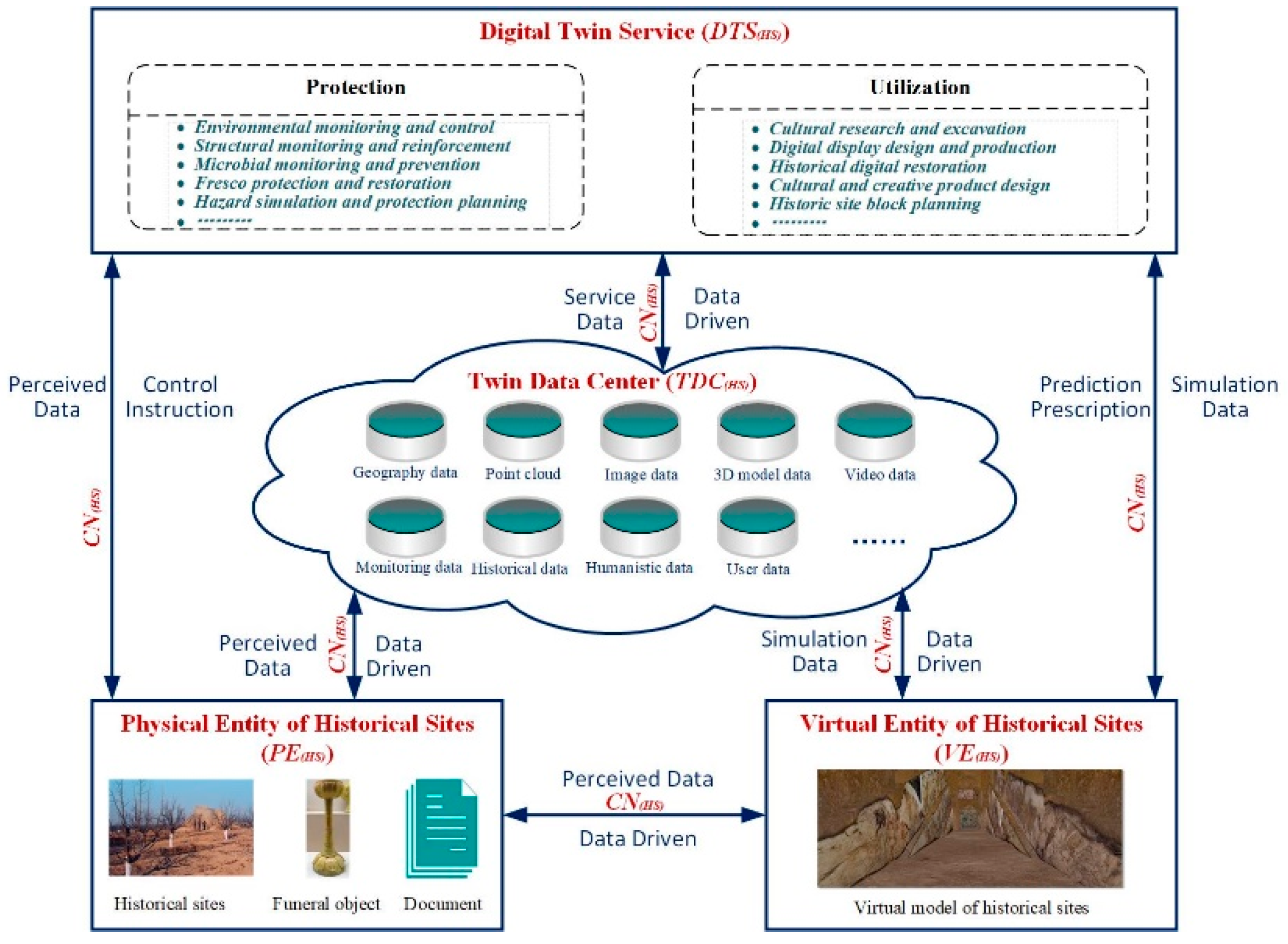
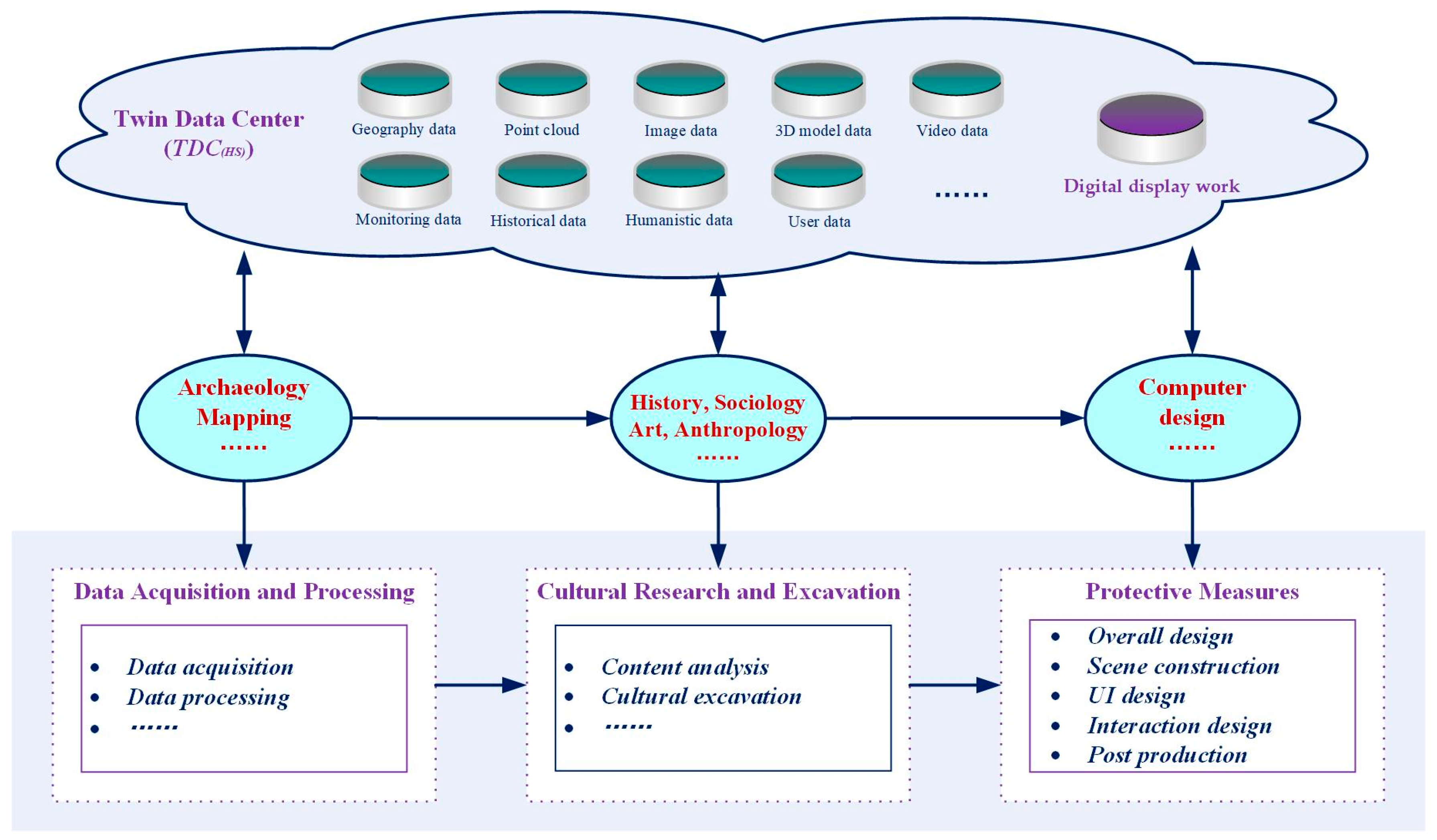
2.1. Digital Twin Model
2.1.1. Physical Entity
2.1.2. Virtual Entity
2.1.3. Digital Twin Service
2.1.4. Twin Data Center
2.1.5. Connection
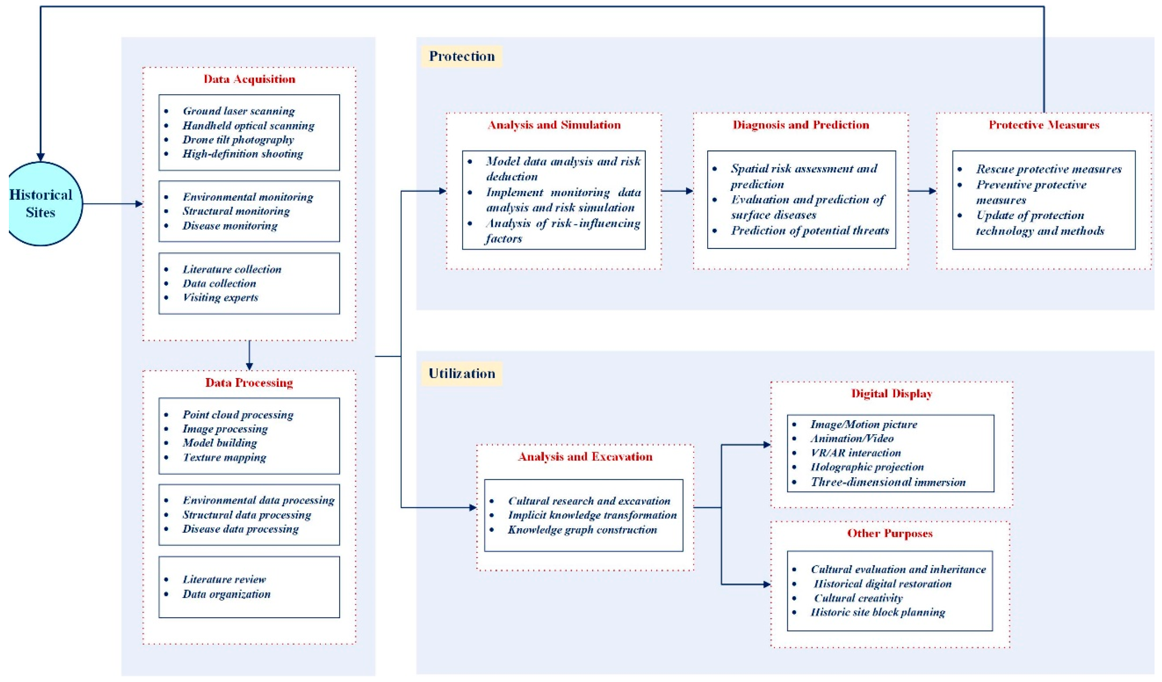
2.2. Technical Process
2.2.1. Basic Work
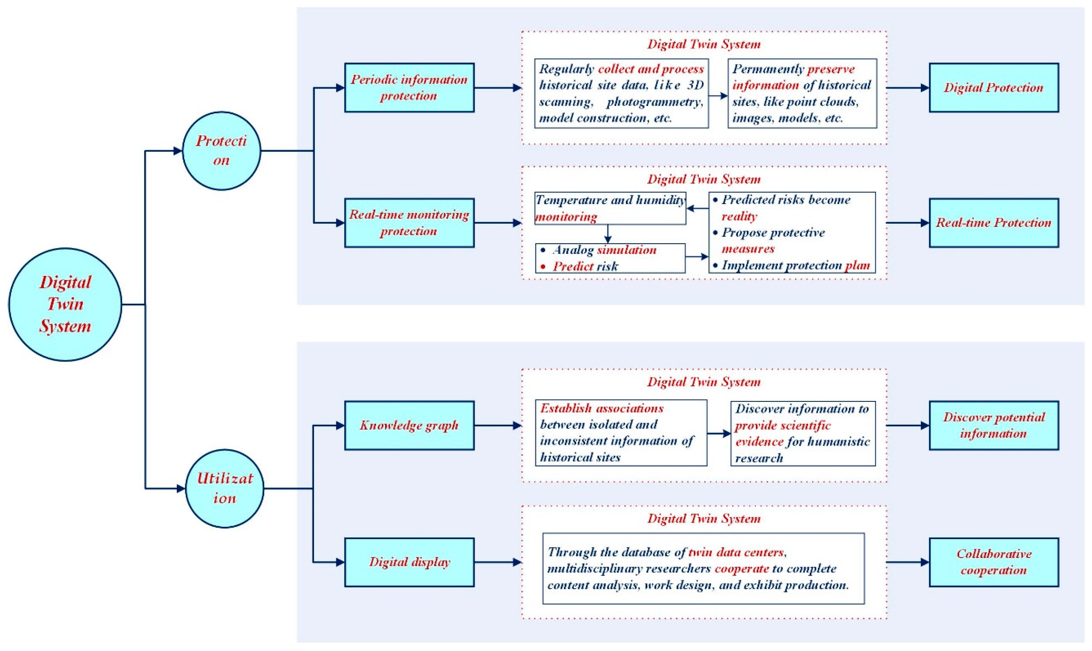
2.2.2. Protection
2.2.3. Utilization
2.3. Method Validation
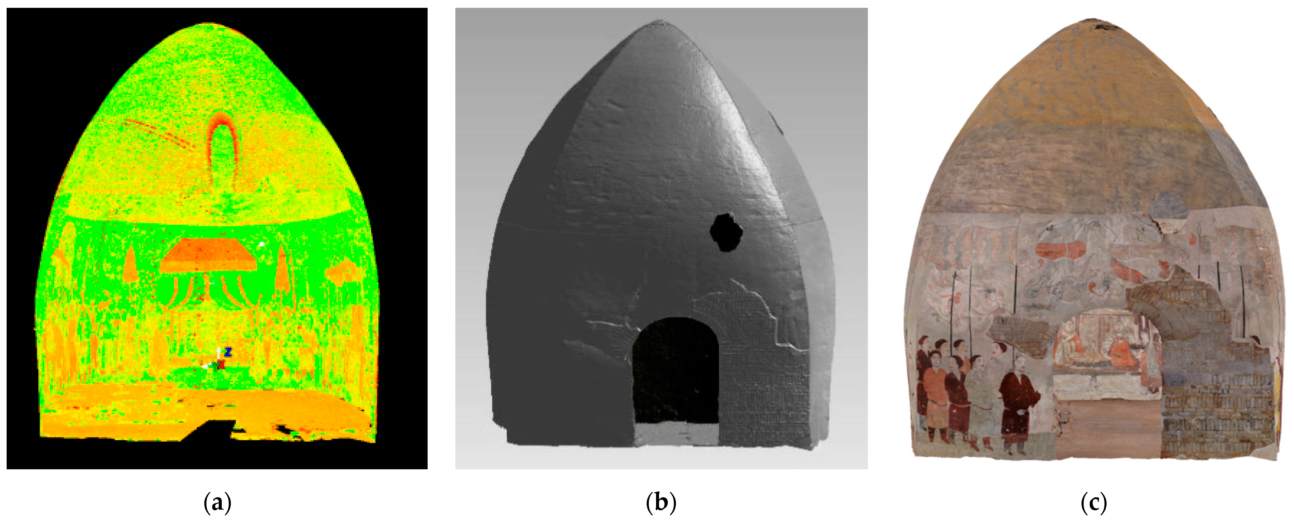
2.3.1. Protection
2.3.2. Utilization
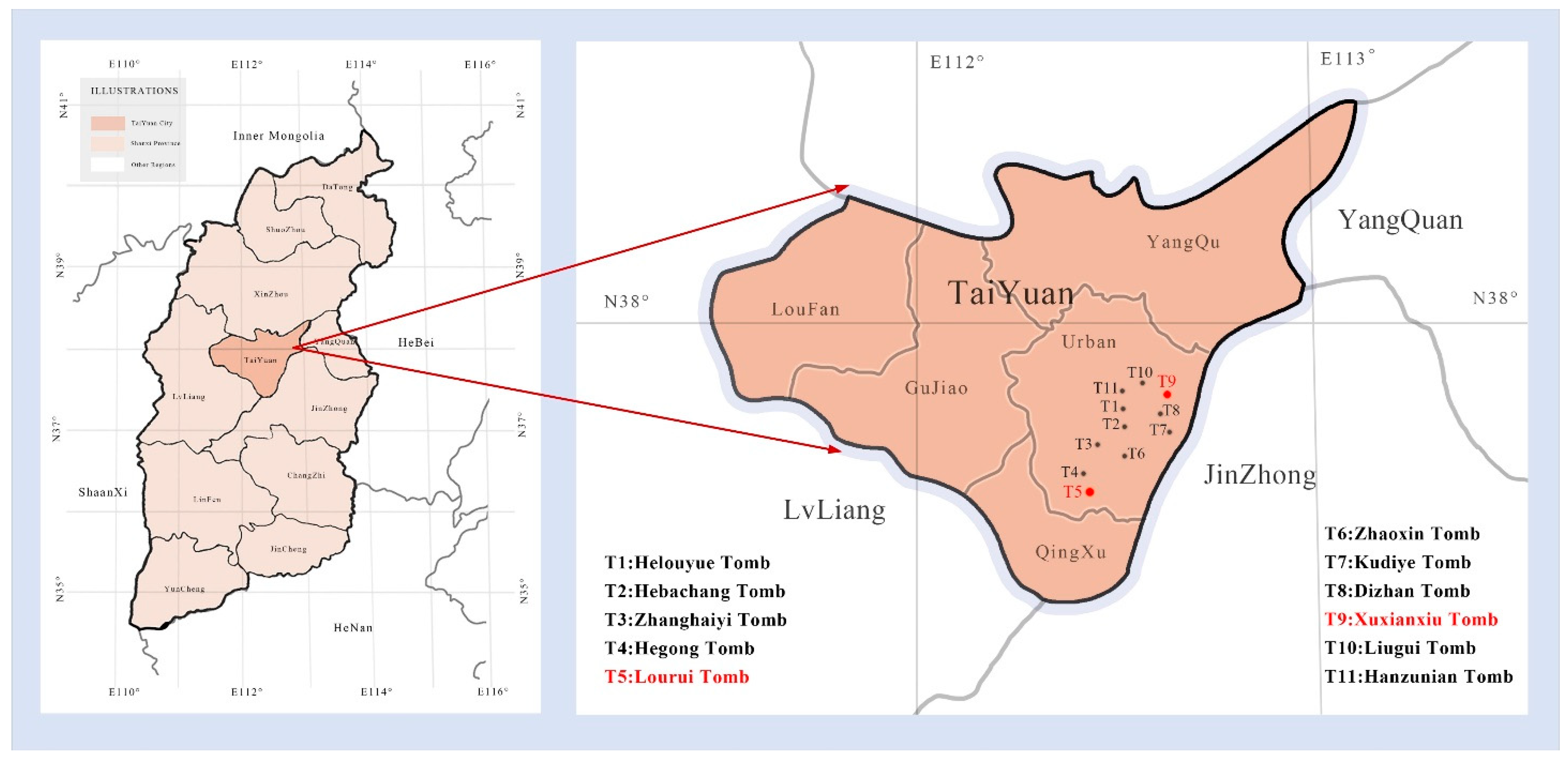
3. Case Study Introduction
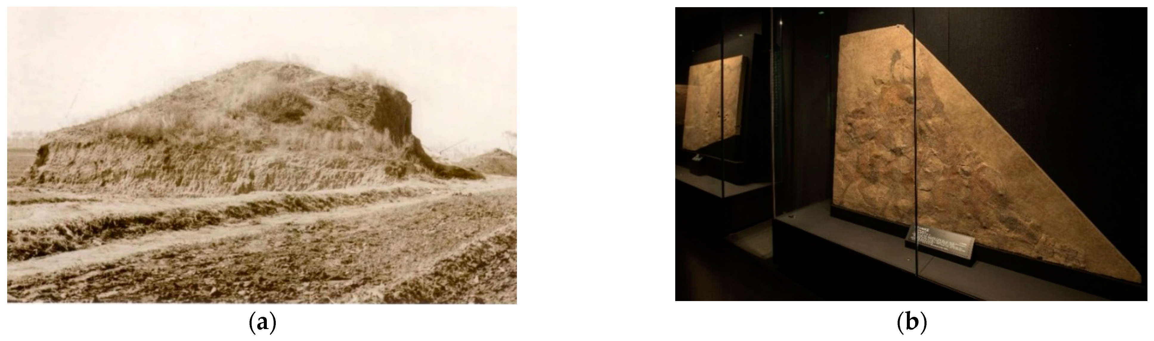
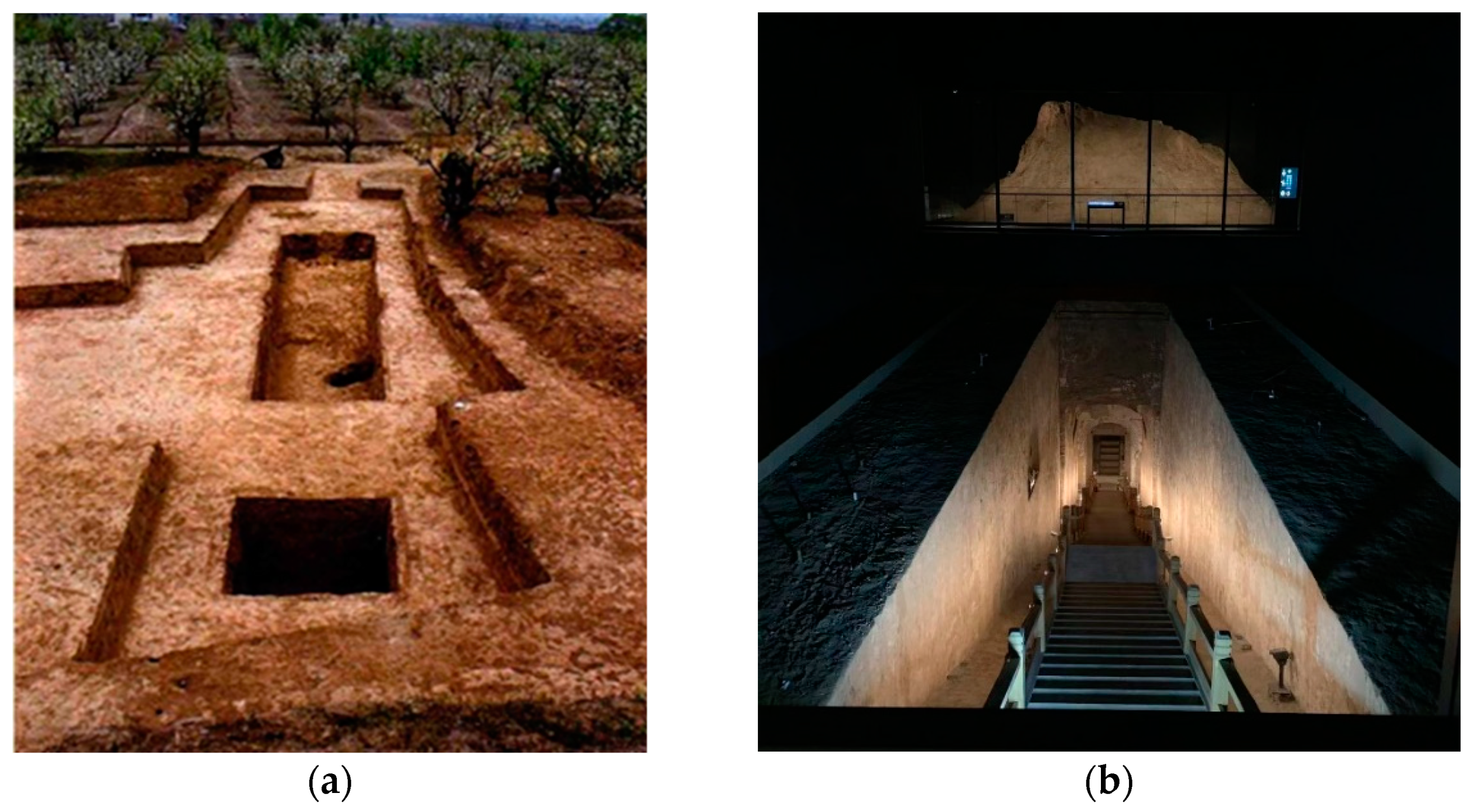
3.1. Xuxianxiu Tomb
3.2. Lourui Tomb
4. Results
4.1. Basic Work
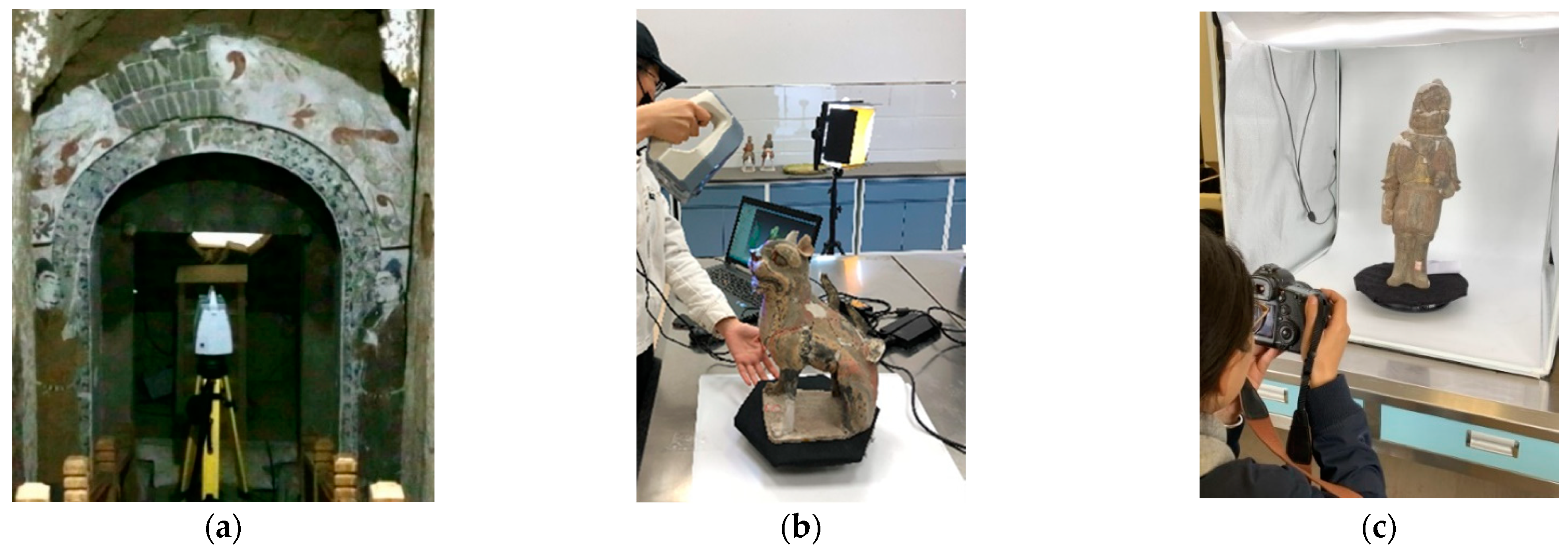
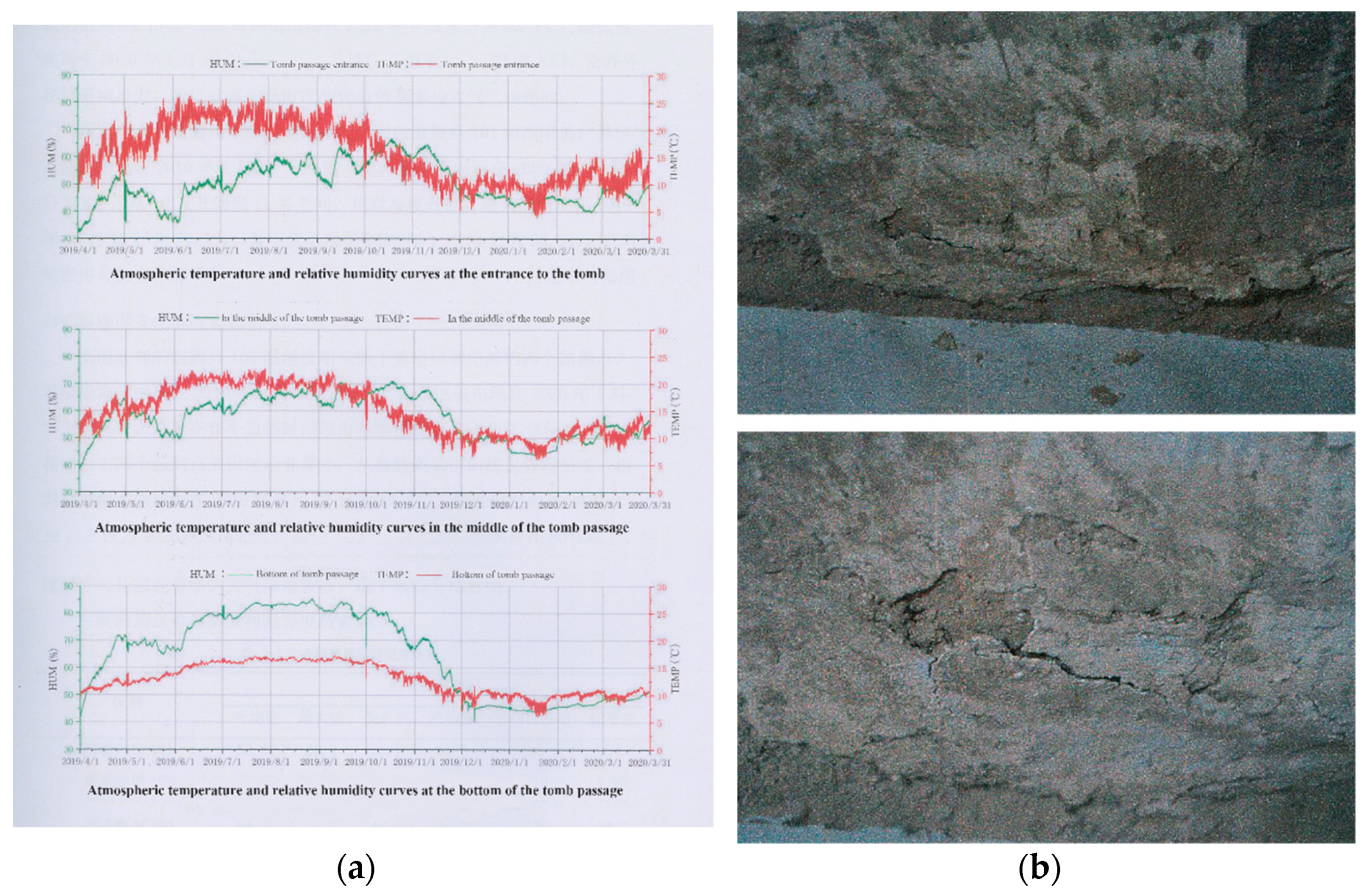
4.1.1. Data Acquisition
4.1.2. Data Processing
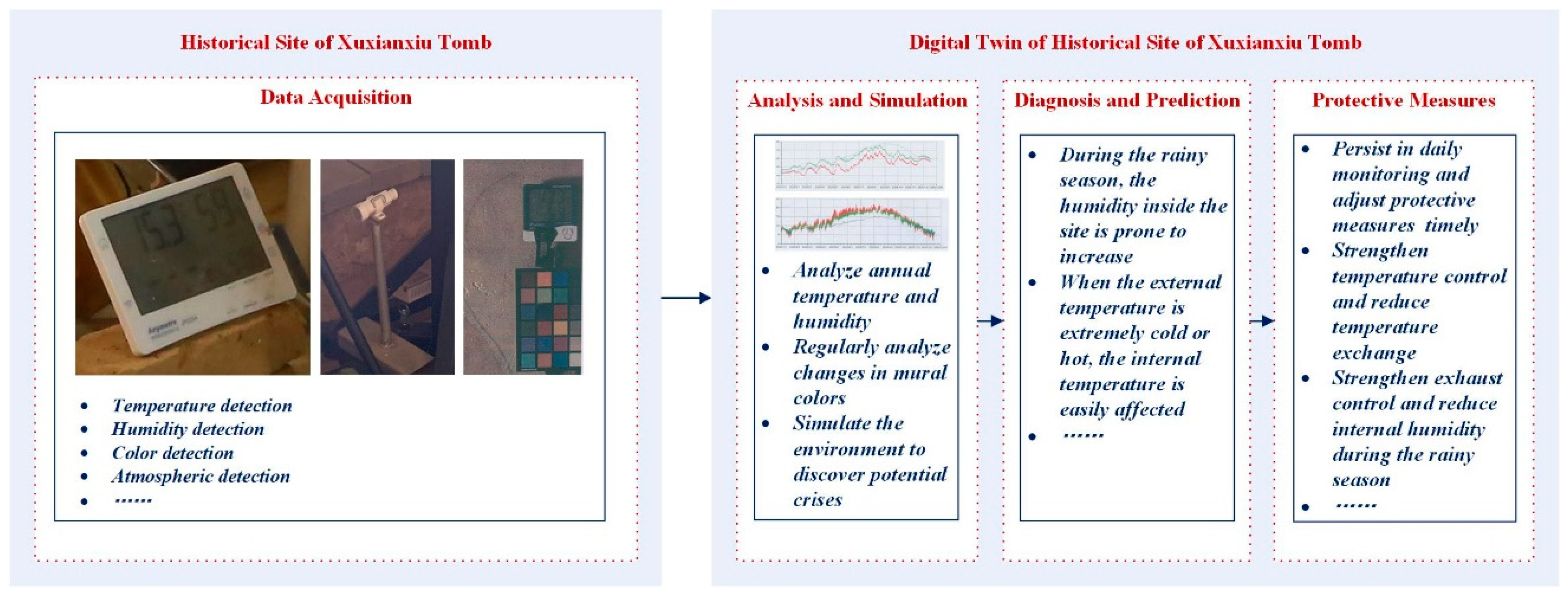
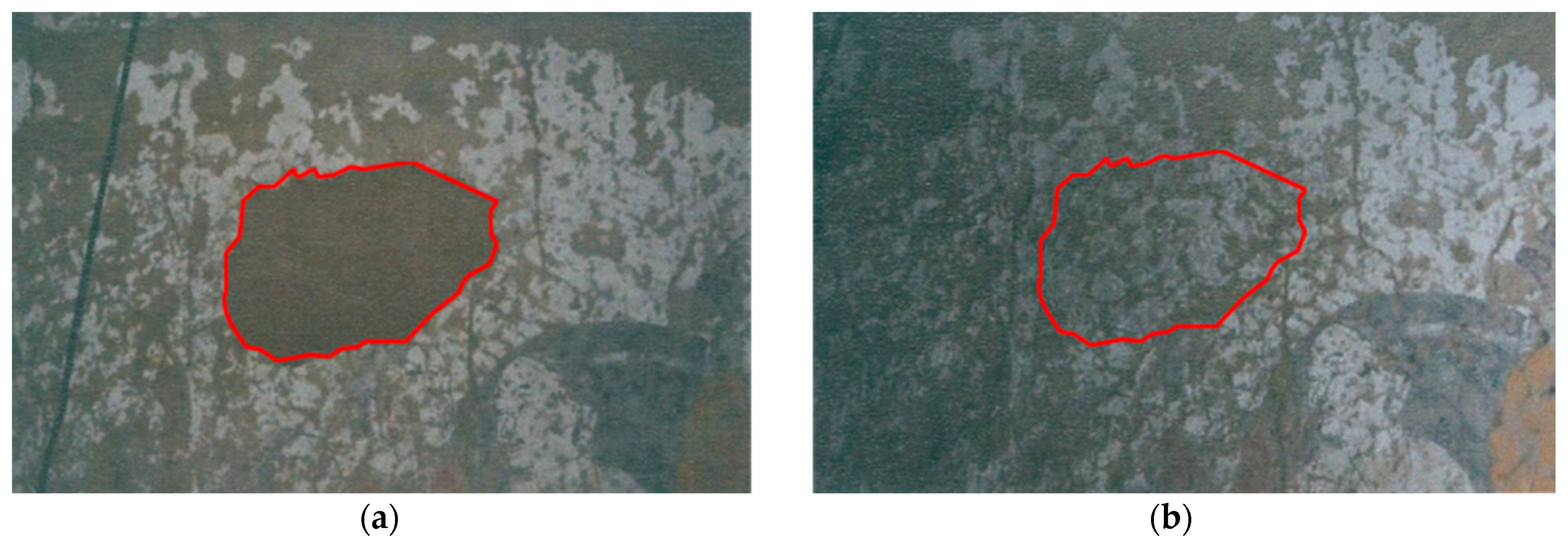
4.2. Protection
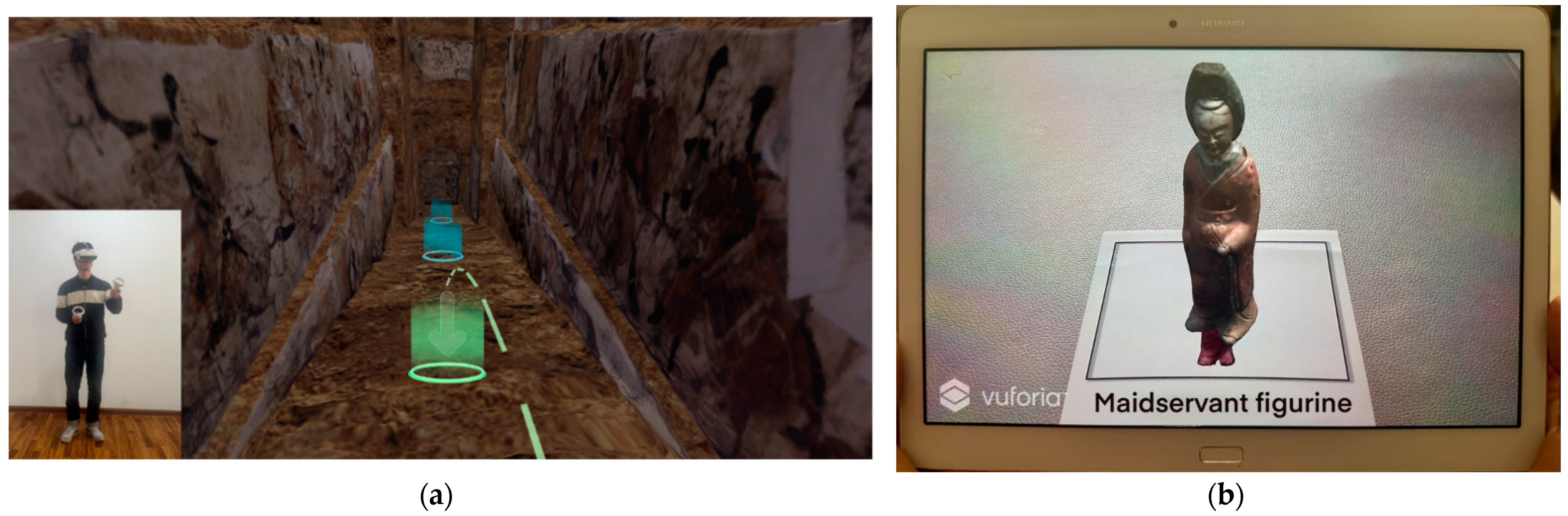
4.3. Utilization
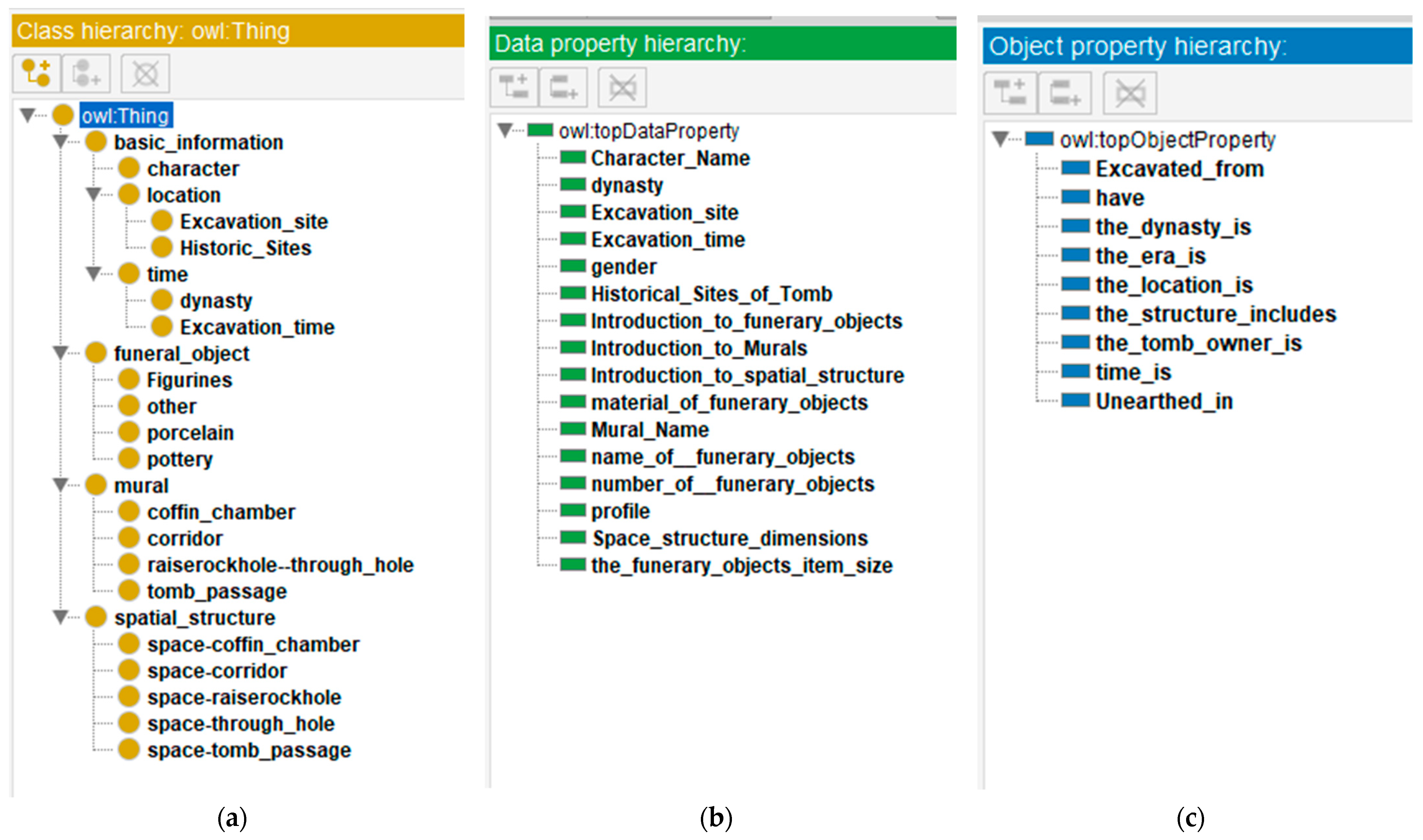
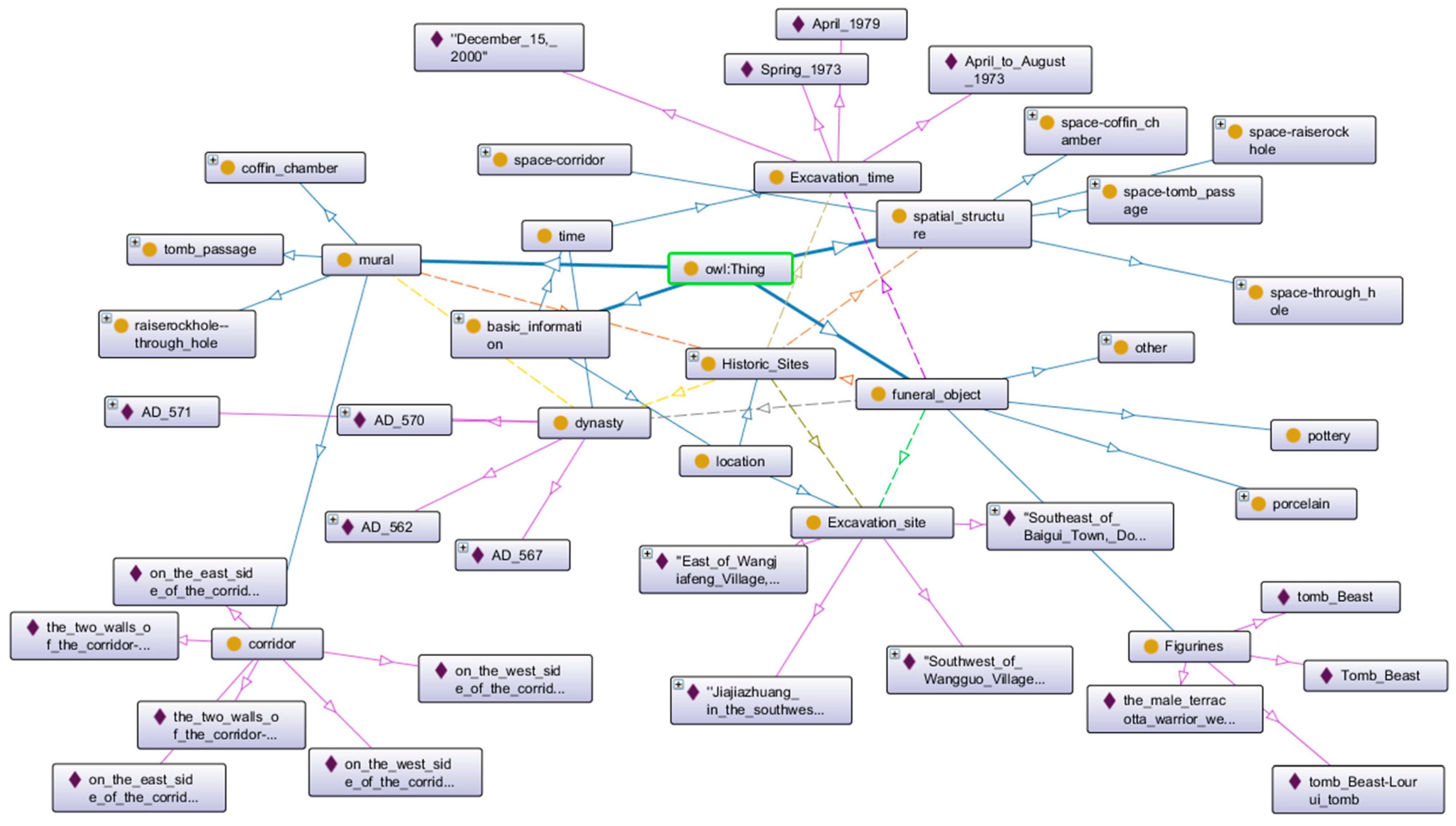
4.3.1. Knowledge Graph
4.3.2. Digital Display
5. Discussion
6. Conclusions
Author Contributions
Funding
Data Availability Statement
Acknowledgments
Conflicts of Interest
References
- UNESCO. Convention concerning the protection of the world cultural and natural heritage. Mus. Int. 1973, 25, 120. [Google Scholar] [CrossRef]
- Ji, G.L. Inheritance and sharing: The dual ethical dimension of cultural heritage protection. Southeast Cult. 2016, 4, 11–16. [Google Scholar]
- Dang, A.; Wang, F. Information Technology Methods for Locality Preservation and Inheritance of Settlement Cultural Landscape. Indoor Built Environ. 2021, 30, 437–441. [Google Scholar] [CrossRef]
- Di Giulio, R.; Boeri, A.; Longo, D.; Gianfrate, V.; Boulanger, S.O.M.; Mariotti, C. ICTs for Accessing, Understanding and Safeguarding Cultural Heritage: The Experience of Inception and Rock H2020 Projects. Int. J. Arch. Herit. 2021, 15, 825–843. [Google Scholar] [CrossRef]
- Van Balen, K. Challenges that preventive conservation poses to the cultural heritage documentation field. Int. Arch. Photogramm. Remote Sens. Spat. Inf. Sci. 2017, 42, 713–717. [Google Scholar] [CrossRef]
- Acke, L.; Vis, K.D.; Verwulgen, S.; Verlindenet, J. Survey and literature study to provide insights on the application of 3D technologies in objects conservation and restoration. J. Cult. Herit. 2021, 49, 279–288. [Google Scholar] [CrossRef]
- Creed, C.; Al-Kalbani, M.; Theil, A.; Sarcar, S.; Williams, I. Inclusive AR/VR: Accessibility barriers for immersive technologies. Univers. Access Inf. Soc. 2023, 23, 59–73 . [Google Scholar] [CrossRef]
- Geng, G.H.; He, X.L.; Wang, M.L.; Kang, L.; He, X. Research progress of key technologies for cultural heritage activation. Chin. J. Image Graph. 2022, 27, 1988–2007. [Google Scholar]
- Grieves, M.W. Product lifecycle management: The new paradigm for enterprises. Int. J. Prod. Dev. 2005, 2, 71–84. [Google Scholar] [CrossRef]
- Shafto, M.; Conroy, M.; Doyle, R.; Glaessgen, E.; Kemp, C.; LeMoigne, J.; Wang, L. Modeling, Simulation, Information Technology and Processing Roadmap; NASA: Washingtong, DC, USA, 2010. Available online: https://www.researchgate.net/publication/280310295 (accessed on 1 May 2010).
- Grieves, M. Digital Twin: Manufacturing Excellence through Virtual Factory Replication; White Paper; Dassault Systèmes: Vélizy-Villacoublay, France, 2015; pp. 1–7. Available online: https://www.researchgate.net/publication/275211047 (accessed on 1 March 2015).
- Themistocleous, K.; Evagorou, E.; Mettas, C.; Hadjimitsis, D. The Use of Digital Twin Models to Document Cultural Heritage Monuments. In Proceedings of the Earth Resources and Environmental Remote Sensing/GIS Applications XIII; SPIE: Bellingham, WA, USA, 2022; Volume 12268, p. 122680. [Google Scholar] [CrossRef]
- Shabani, A.; Skamantzari, M.; Tapinaki, S.; Georgopoulos, A.; Plevris, V.; Kioumarsi, M. 3D simulation models for developing digital twins of heritage structures: Challenges and strategies. In Proceedings of the 4th International Conference on Structural Integrity (ICSI 2021), Online, 30 August–2 September 2021; Volume 37, pp. 314–320. [Google Scholar] [CrossRef]
- Jouan, P.; Hallot, P. Digital Twin: Research Framework to Support Preventive Conservation Policies. ISPRS Int. J. Geo-Inf. 2020, 9, 228. [Google Scholar] [CrossRef]
- Massafra, A.; Predari, G.; Gulli, R. Towards Digital Twin Driven Cultural Heritage management: A HBIM-Based Workflow for Energy Improvement of Modern Buildings. Int. Arch. Photogramm. Remote Sens. Spat. Inf. Sci. 2022, 46, 149–157. [Google Scholar] [CrossRef]
- Zhang, Z.; Dang, A.R.; Hou, D.X.; Wang, Z.N.; Zhang, Z.W.; Xin, T.Q. Information technology methodology of the protection and utilization of the Great Wall Cultural Heritage System. Natl. Remote Sens. Bull. 2021, 25, 2339–2350. [Google Scholar] [CrossRef]
- Jia, H.M.; Yan, J. Construction of Heritage Digital Resource Platform Based on Digital Twin Technology. Math. Probl. Eng. 2022, 8, 4361135. [Google Scholar] [CrossRef]
- Zhao, J.; Guo, L.; Li, Y.Q. Application of Digital Twin Combined with Artificial Intelligence and 5G Technology in the Art Design of Digital Museums. Wirel. Commun. Mob. Comput. 2022, 12, 8214514. [Google Scholar] [CrossRef]
- Cruz Franco, P.A.; Rueda Márquez de la Plata, A.; Gómez Bernal, E. Protocols for the Graphic and Constructive Diffusion of Digital Twins of the Architectural Heritage That Guarantee Universal Accessibility through AR and VR. Appl. Sci. 2022, 12, 8785. [Google Scholar] [CrossRef]
- Fabbrocino, G. Combining Integrated Informative System and Historical Digital Twin for Maintenance and Preservation of Artistic Assets. Sensors 2021, 21, 5956. [Google Scholar] [CrossRef]
- Brumana, R.; Quilici, S.; Oliva, L.; Previtali, M.; Gabriele, M.; Stanga, C. Multi-Sensor HR Mass Data Models toward Multi-Temporal-Layered Digital Twins: Maintenance, Design and XR Informed Tour of the Multi-Stratified Appian Way (PAAA). Sensors 2023, 23, 8556. [Google Scholar] [CrossRef]
- Grieves, M.; Vickers, J. Digital Twin: Mitigating Unpredictable, Undesirable Emergent Behavior in Complex Systems. In Transdisciplinary Perspectives on Complex Systems: New Findings and Approaches; Springer International Publishing: Cham, Switzerland, 2017; pp. 85–113. ISBN 978-3-319-38756-7. [Google Scholar]
- Tao, F.; Liu, W.; Liu, J.; Liu, X.; Liu, Q.; Qu, T.; Hu, T.; Zhang, Z.; Xiang, F.; Xu, W. Digital twin and its potential application exploration. Comput. Integr. Manuf. Syst. 2018, 24, 1–18. [Google Scholar] [CrossRef]
- Huang, H.; Ge, W.; Liu, W.W.; Rongrong, Q.; Jie, L. Building change detection using tilted image reconstruction point cloud. Bull. Surv. Mapp. 2023, 5, 125–129. [Google Scholar] [CrossRef]
- Zhang, X.; Zhi, Y.; Xu, J.; Han, L. Digital Protection and Utilization of Architectural Heritage Using Knowledge Visualization. Buildings 2022, 12, 1604. [Google Scholar] [CrossRef]
- Feng, Q. Research on Knowledge Graph Construction Technology for Cultural Relics Collections. Master’s Thesis, Northwest University, Xi’an, China, 2023. [Google Scholar]
- Jia, J.; He, Y.; Gao, M. Exploring the Scenery of the Old Summer Palace from Multiple Perspectives. Decoration 2015, 12, 4. [Google Scholar] [CrossRef]
- Li, S.J.; Cui, Y.H. Economic and cultural exchanges between Jinyang in Northern Qi and Eurasia. Res. China Econ. Hist. 2009, 2, 82–88. [Google Scholar]
- Zhang, Q.J. The Historical Position of Shanxi in the Northern Dynasties--An Introduction to the Silk Road and the Northern Dynasties’ Pingcheng Jinyang. J. Hist. Chorography 2015, 1, 14–19. [Google Scholar] [CrossRef]
- Taiyuan Institute of Cultural Relics and Archaeology. The Xuxianxiu Tomb of Northern Qi Dynasty; Cultural Relics Publishing House: Beijing, China, 2005; ISBN 978-7-5010-1783-6. [Google Scholar]
- Wang, W.F. Study on the Conservation and Restoration of Mural Paintings in the Xuxianxiu Tomb of Northern Qi Dynasty; Cultural Relics Publishing House: Beijing, China, 2016; ISBN 978-7-5010-4412-2. [Google Scholar]
- Chang, Y.M.; Pei, J.R.; Wang, P.J. Briefing on the excavation of Xuxianxiu Tomb in Northern Qi Dynasty, Taiyuan. Cult. Relics 2003, 10, 18. [Google Scholar]
- Shanxi Institute of Cultural Relics and Archaeology; Taiyuan Institute of Cultural Relics and Archaeology. The Lourui Tomb of Northern Qi Dynasty; Cultural Relics Publishing House: Beijing, China, 2006; ISBN 978-7-5010-1887-1. [Google Scholar]
- Wu, Z.R. Mural paintings from the tomb of Dongan King of Northern Qi Dynasty. Cult. Relics 1983, 10, 24. [Google Scholar]
- Tao, Z.G. Mural paintings and sculptures from the Lourui Tomb of Dongan King of Northern Qi Dynasty. Art Res. 1984, 1, 44–48+54–64. [Google Scholar]
- Gennari, J.H.; Musen, M.A.; Fergerson, R.W.; Grosso, W.E.; Crubézy, M.; Eriksson, H.; Noy, N.F.; Tu, S.W. The Evolution of Protégé: An Environment for Knowledge-Based Systems Development. Int. J. Hum. Comput. Stud. 2003, 58, 89–123. [Google Scholar] [CrossRef]
- Baudrillard, J. The System of Objects; Verso: London, UK, 1996; ISBN 978-1-8598-4068-9. [Google Scholar]


Disclaimer/Publisher’s Note: The statements, opinions and data contained in all publications are solely those of the individual author(s) and contributor(s) and not of MDPI and/or the editor(s). MDPI and/or the editor(s) disclaim responsibility for any injury to people or property resulting from any ideas, methods, instructions or products referred to in the content. |
© 2024 by the authors. Licensee MDPI, Basel, Switzerland. This article is an open access article distributed under the terms and conditions of the Creative Commons Attribution (CC BY) license (https://creativecommons.org/licenses/by/4.0/).
Share and Cite
Liu, Z.; Wang, J. Protection and Utilization of Historical Sites Using Digital Twins. Buildings 2024, 14, 1019. https://doi.org/10.3390/buildings14041019
Liu Z, Wang J. Protection and Utilization of Historical Sites Using Digital Twins. Buildings. 2024; 14(4):1019. https://doi.org/10.3390/buildings14041019
Chicago/Turabian StyleLiu, Zherong, and Jiang Wang. 2024. "Protection and Utilization of Historical Sites Using Digital Twins" Buildings 14, no. 4: 1019. https://doi.org/10.3390/buildings14041019
APA StyleLiu, Z., & Wang, J. (2024). Protection and Utilization of Historical Sites Using Digital Twins. Buildings, 14(4), 1019. https://doi.org/10.3390/buildings14041019