Article

Enhancing Risk Management in Road Infrastructure Facing Flash Floods through Epistemological Approaches

by
Victor Andre Ariza Flores
1,*,
Fernanda Oliveira de Sousa
2 and
Sandra Oda
2
1
Escuela de Posgrado, Universidad Tecnológica del Perú, Lima 15046, Peru
2
Transport Engineering Program—PET/COPPE, Federal University of Rio de Janeiro, Rio de Janeiro 21941-598, Brazil
*
Author to whom correspondence should be addressed.
Buildings 2024, 14(7), 1931; https://doi.org/10.3390/buildings14071931
Submission received: 30 April 2024 / Revised: 2 June 2024 / Accepted: 13 June 2024 / Published: 25 June 2024
(This article belongs to the Special Issue Built Environments and Environmental Buildings)

Abstract

:
This study examines the integration of epistemological principles into road infrastructure risk management, emphasizing the need for adaptive strategies in the face of inherent climate uncertainties, particularly flash floods. A systematic review of peer-reviewed articles, industry reports, and case studies from the past two decades was conducted, focusing on the application of epistemological approaches within the infrastructure sector. The research employs a mixed methods approach. Quantitatively, the risk of pavement failure is measured by analyzing the relationship between pavement serviceability rates and Intensity–Duration–Frequency (IDF) data in areas frequently affected by flash floods. For example, rainfall intensities during flood events on the BR-324 highway in Brazil were significantly higher than monthly averages, with maximum values reaching 235.73 mm for a 5 min duration over a 50-year return period. These intensities showed an increase of approximately 15% over 5 to 10 years and 8% over 50 to 75 years. Qualitatively, traditional risk management methods are combined with epistemological concepts. This integrated approach fosters reflective practice, encourages the use of both quantitative and qualitative data, promotes a dynamic management environment, and supports sustainable development goals by aligning risk management with environmental and social sustainability. This study finds that incorporating epistemological insights can lead to more fluid and continuously improving risk management practices in construction, design, and maintenance. It concludes with a call for future research to explore the integration of emerging technologies such as artificial intelligence to further refine these approaches and more effectively manage complexity and uncertainty.

1. Introduction

Due to climate changes, the occurrence of natural disasters such as heat waves, floods, landslides, and erosion has become increasingly frequent, significantly impacting the economy, society, and transportation infrastructures. In response, numerous studies on risk and disaster management have been conducted in recent years to establish metrics for assessing the impacts of these events across various industries. Particularly in the pavement sector, risk management involves defining key assets, rates of deterioration, and potential failures, considering the implications of multiple strategic or financial circumstances [1].
The road infrastructure sector is highly susceptible to risk, with factors such as cost, time, and quality influencing project success. Despite this, risk management techniques are underutilized due to a lack of knowledge and skepticism about their suitability [2,3]. However, the importance of risk management in construction is widely recognized, focusing on risk identification, assessment, response, and control [4]. Despite this recognition, risk management is not implemented consistently, affecting project success [5]. The field of risk management in construction is rapidly evolving, with a growing body of literature emphasizing practical applications. Research highlights the importance of accurately identifying and responding to risks in construction companies [6,7] and the need for strategic risk management in small construction companies, which can help them transition to medium-sized companies [8]. Future research trends include the development of digital management platforms and decision-making systems [9].
Epistemology, as a branch of philosophy concerned with the study of knowledge and justification, offers a theoretical framework for understanding and addressing uncertainty in risk management. The intersection between epistemology and risk management is a critical area of research [10], emphasizing the need for rigorous validation of risk measures and highlighting the potential unreliability of current methods, particularly in economics, finance, and insurance. Further exploration of the ethical dimensions of risk management, especially in financial markets and organizations, underscores the significance of this approach [11]. Studies delve into the epistemology of risk, calling for a re-examination of risk in relation to language and logic, and discussing the production of knowledge about risks, particularly in the context of new technologies [12,13].
The study of epistemology can foster further reflection and learning in the road sector, leading to improvements in professional practice and the effectiveness of risk management. This study aims to integrate epistemological principles into road infrastructure risk management, promoting adaptive strategies amidst inherent climate uncertainties. By combining traditional risk management methods with epistemological concepts, this research advocates for more fluid and continuously improving practices in construction, design, and maintenance. The study also suggests future research should explore the integration of emerging technologies, such as artificial intelligence, to further refine these approaches and manage complexity and uncertainty more effectively.
The study hypothesizes that integrating epistemological principles into road infrastructure risk management enhances the adaptability and effectiveness of risk management practices, leading to improved resilience against climate-induced uncertainties. To explore this, the research seeks to answer the following questions: How can epistemological principles be effectively integrated into traditional risk management frameworks for road infrastructure? What are the impacts of this integration on the identification, assessment, and mitigation of risks in the context of pavement failures due to climate events? How can emerging technologies, such as artificial intelligence, be leveraged to support the integration of epistemological approaches in risk management?

2. Literature Review

2.1. Uncertainty in Risk Management

Uncertainty in projects can stem from various sources and can be classified into several types, each contributing differently to the risk landscape. The term “uncertainty” can have different meanings depending on the philosophy you adopt; some see the universe as random, while others believe in determination and attribute uncertainty to a lack of knowledge. Uncertainty can also be caused by erroneous assumptions or events that contradict widely accepted knowledge, which are not usually part of a standard risk assessment process in a project [14]. Understanding these types of uncertainty is crucial for effective risk management, particularly in road infrastructure projects facing climate-induced challenges.
Aleatoric uncertainty is inherent to the variability of the environment and is measured through relative frequencies, such as the occurrence of an event in repeated experiments. Aleatoric uncertainty is objective and independent of the observer, often expressed through probabilities derived from empirical data [15,16]. A probability is a relative frequency pushed to the limit according to the following mathematical expression:
p i = lim n f i = lim n n i N
Risk and uncertainty are closely related in a project, as uncertainty can lead to risks [17,18]. Epistemic uncertainty arises from a lack of knowledge about a phenomenon and highlights the limitations of our understanding. It is not based on relative frequencies, as it pertains to events that may occur infrequently or only once [19,20]. Epistemic uncertainty can make decision-making challenging [21] but also opens opportunities for innovation [22]. Managers and engineers often deal with this by using subjective probabilities to account for the unknown factors [23].
Agnostic uncertainty involves a mix of frequentist and epistemic perspectives and includes volitional uncertainty, which is influenced by human judgment and potential biases. Volitional uncertainty reflects the potential for the manipulation of probabilities to benefit specific interests, requiring consideration of feedback, psychology, and game theory in predictions [24,25,26].
Ontological uncertainty refers to the fundamental uncertainty about the nature of reality or the system being studied, such as the feasibility of a new design. In project management, ontological uncertainty challenges the basic assumptions and technical foundations of a project [27,28]. In the realm of engineering, epistemology is not merely an abstract exploration of knowledge but a practical tool that enhances the effectiveness and ethical grounding of risk management [29,30]. A robust approach to managing aleatory and epistemic uncertainties through the use of gradients and surrogate models demonstrates how advanced optimization techniques can significantly improve decision-making in risk management [31,32,33].
Understanding and managing these uncertainties is crucial for the risk management of road infrastructure projects. Effective risk assessment involves identifying how these uncertainties translate into potential risks and developing strategies to mitigate them. This approach aligns with the goal of integrating epistemological principles to enhance decision-making and resilience in infrastructure projects facing climate uncertainties.

2.2. Theoretical Approach in Risk Management and Risk Assessment

Risk is defined by [34] as the effect of uncertainty on objectives. Generally, risk analysis comprises two main concepts: risk management and risk assessment.
Risk management is a systematic and ongoing process that seeks to identify, evaluate, and control factors that may adversely affect an organization, project, or initiative. It includes identifying risks, assessing their potential impact, and selecting strategies to mitigate or avoid risks. Risk management can also involve the constant monitoring and review of risks and the steps taken to address them [35,36,37].
The goal of risk management is to minimize the likelihood and negative impact of uncertain events and help the organization achieve its goals more effectively and efficiently. This is achieved by implementing preventive measures and preparing to respond to unforeseen events effectively [38]. Risk management helps organizations become more resilient and prepared to face unforeseen challenges and events.
On the other hand, risk assessment consists of evaluating, identifying and measuring risk. The concept of risk can be understood and measured in either qualitative or quantitative terms. Qualitative employs narratives, color coding, and risk matrices to evaluate potential hazards, while quantitative analysis utilizes probabilistic frameworks that incorporate assessments of both hazards and subsequent outcomes [34,39]. Within the realm of qualitative risk appraisal, the risk matrix is a prevalent tool; it is occasionally referred to as a pseudo-quantitative technique due to its incorporation of numerical values in the absence of a formal mathematical framework. This approach allocates numerical scores to the probability and ramifications associated with a risk, with the aggregate of hazard likelihood and impact categories culminating in an assigned risk level. Table 1 illustrates an example of a risk matrix.
Climate change is not a risk in itself. However, in road infrastructure, risks result from the interaction of climate-related risks (floods, erosion, collapse, landslides, etc.) with the exposure and vulnerability of infrastructure. Thus, assessing infrastructure risks is essential, especially when they are located in areas susceptible to extreme weather events such as flooding [40].
Summarizing, the theory of decision is not enough to build a complete analysis of the notion of risk [41,42]. Because of that, it is compulsory to manage an integrative approach to addressing uncertainty.

2.3. Flood Risk Assessment

Floods impact a greater number of individuals globally than any other type of natural disaster. Typically, floods occur when intense or persistent rainfall overwhelms the soil’s ability to absorb water and surpasses the carrying capability of waterways and coastal regions. Several phenomena can trigger flooding, including severe thunderstorms, twisters, hurricanes, rainy seasons. Among all flooding types, flash floods—which can arise abruptly—are particularly dangerous [43].
In case of flash floods, one of the main aspects of designing effective risk plans is understanding the behavior of rainfall. It is common to use Intensity–Duration–Frequency (IDF) and Depth–Duration–Frequency (DDF) curves for rainfall pattern studies. IDF curves describe the relationship between rainfall intensity, for various return periods and different durations. usually ranging from 5 min to 24 h. IDF is expressed mathematically as follows in Equation (2).
i =     K × T a ( t + b ) c
where
i —is the maximum average intensity (mm/h);
t—is the rainfall duration (hour);
T—is the return period (year);
K, a, b, c—are adjustment parameters of the IDF relationship.
The parameters K, a, b and c are adjusted considering the rainfall intensity of each region. Generally, in Brazil, the parameters available in the database of the free software Plúvio 2.1 [44] are used to calculate the IDF. DDF is similar to the IDF procedure, but the Depth–Duration–Frequency curve uses rainfall depths instead of intensities and provides rainfall accumulation depths. Current estimates of these curves are obtained through the frequency analysis of historical rainfall observations, assuming that the same underlying processes will govern future rainfall patterns. Faced with a constantly changing climate, it is essential to continually update and adapt the IDF and DDF curves in order to accurately assess flood risks. Recent studies show that climate change and urbanization can increase the frequency of this type of flooding, especially in urban areas [43,45].
With regard to road infrastructure, this type of event mainly affects the pavement. The presence of water can significantly affect the durability and performance of flexible pavement. Understanding the main causes of water damage is crucial for effective pavement maintenance and longevity. High levels of rainfall often overload the drainage system, subjecting the pavement structure to frequent water saturation, which can lead to erosion. Long-term saturation triggers deterioration processes, especially in flexible pavements, due to the degradation of the surface materials. The interaction forces between the asphalt and the asphalt aggregate gradually lose cohesion and adhesion, weakening the mixture [45]. In addition, the saturation process affects the resilient behavior of the pavement layers as a whole, as it can reduce their stiffness [46]. Accumulated water can compromise the sub-base, leading to a loss of load-bearing capacity, wear and deformation of the pavement surface. Proper installation and maintenance of drainage systems, including ditches, gutters and well-designed rainwater management facilities, are essential to prevent deterioration caused by water.
Road projects include a crucial pluviometry study phase. The aim of this study is to determine the flows needed to identify the dimensions of new drainage works and to check the sufficiency of existing ones. This involves collecting and analyzing rainfall data to define a rainfall model that is representative of the project region. These data are applied to design the necessary drainage structures, such as culverts and channels, ensuring that the road infrastructure is resilient to local climatic conditions. Drainage works are generally designed for extreme values in order to ensure the safety of the structure. Nevertheless, the historical series used in the design does not necessarily always represent the peak values. It is therefore necessary to use probabilistic studies to model rainfall patterns. In Brazil, the most widely used model for obtaining rainfall intensity is represented by Equation (2).
One of the main variables in IDF curves is the return time. The recurrence time (or recurrence period, or return time) is the average interval of years in which a given event can occur or be overcome. The selection and justification of a certain return period for a construction project is related to the analysis of the economics and safety of the project (risk analysis). The longer the return period, the higher the peak flow values found and, consequently, the safer and more expensive the project will be. According to the National Department of Transport Infrastructure [47], the recurrence time for road design is 5 years to 10 years for surface drainage and 1 year for deep drainage.
The methodology proposed in this case study aims to analyze the susceptibility to flooding of the road sections studied by examining the rainfall pattern, obtained by calculating the IDF (Intensity–Duration–Frequency) curves. The study seeks to verify whether the existing drainage system, designed approximately 50 years ago, is capable of efficiently handling the current rainfall pattern. To better illustrate this, data from flooding cases in the stretches studied are presented. In addition, the methodology includes determining the associated risks through an epistemological approach, evaluating the uncertainties in the historical data and the probabilistic models used. This approach allows for a more robust understanding of the risks of flooding, helping to make informed decisions for adapting and improving road drainage systems.
The proposed approach has several limitations and assumptions that must be considered. One major limitation is the reliance on historical rainfall data for developing IDF and DDF curves, which may not accurately reflect future climate conditions. Additionally, the accuracy of the parameters K, a, b, and c in the IDF relationship can vary, especially when extrapolating to new climatic scenarios. Obtaining precise and consistent data to adjust these parameters can be challenging, particularly in regions with limited meteorological data. The approach also assumes that the underlying processes governing rainfall patterns will remain constant, which may not hold true under changing climate conditions. Furthermore, it is assumed that updated IDF and DDF curves will adequately capture the variability in rainfall intensity and frequency due to climate change. The effectiveness of these curves also depends on the representativeness and suitability of existing drainage infrastructures, which may not always be the case.
Finally, the absence of data on the Pavement Condition Index (PCI) for the sections studied limited the analysis, preventing an in-depth investigation into the relationship between the development of pavement deformations and frequent exposure to water from floods.

2.4. Pavement Failure Risk Assessment

The failures observed on pavements may be classified into two main categories: structural failures and functional failures. Structural failures are related to the loss of capacity of a layer, or of the entire pavement structure, to bear the acting loads. In the case of functional failure, the pavement loses its serviceability (e.g., potholes, irregularities) [48].
There are several indices for measuring the quality of asphalt pavements, with the most commonly used being the Pavement Condition Index (PCI), the Present Service Index (PSI) and the Present Service Rating (PSR). Of these, the most widely used to determine structural deterioration is the PCI, which classifies the quality of the pavement through analysis of its surface. The method assigns a score from 0 to 100 to the section analyzed, where 0 means a deteriorated condition and 100 means pavements in perfect condition. Additionally, pavement condition may be assessed though statistic approaches that estimate the relationship between the International Roughness Index (IRI) and the other indices [49,50].
The unevenness of a pavement surface is generally called “roughness” and is expressed by the International Roughness Index (IRI). The IRI is determined as the variation of the distances of the reference points on the surface in relation to an ideal flat reference plane [51]. The IRI is dimensionally expressed in units of meters per kilometer (m/km) or inches per mile (in/miles). Several studies demonstrate the mathematical relationship between empirical evaluations and IRI values. Generally, pavements with extensive and severe potholes, faults and bumps are likely to have a high level of roughness [52,53].
In Brazil, where the area of this case study is located, the assessment of the condition of pavements is carried out subjectively and the corresponding ranges of values related to the main indices/parameters used in the objective assessment, IRI and PCI [54], are listed in Table 2.
The Brazilian National Department of Transport Infrastructure (DNIT) establishes that a pavement on Brazilian highways is designed to survive medium-length life cycles, generally between 8 and 10 years. Pavement performance is expected to remain within a normally predictable IRI range, with values between 1.5 and 3.5/4.0 (5 ≤ PCI < 2). Within this range, the pavement satisfies the requirements for optimizing the total cost of transport, indicating that it has the appropriate structural and functional attributes. When the pavement nears the end of the cycle (with IRI approximately equal to 3.5/4.0 and PCI ≤ 1), although it still maintains its adequate qualification, its performance approaches the permissible limit, indicating that the deterioration process is accelerating [54].

3. Materials and Methods

3.1. Integrative Approach to Addressing Uncertainty
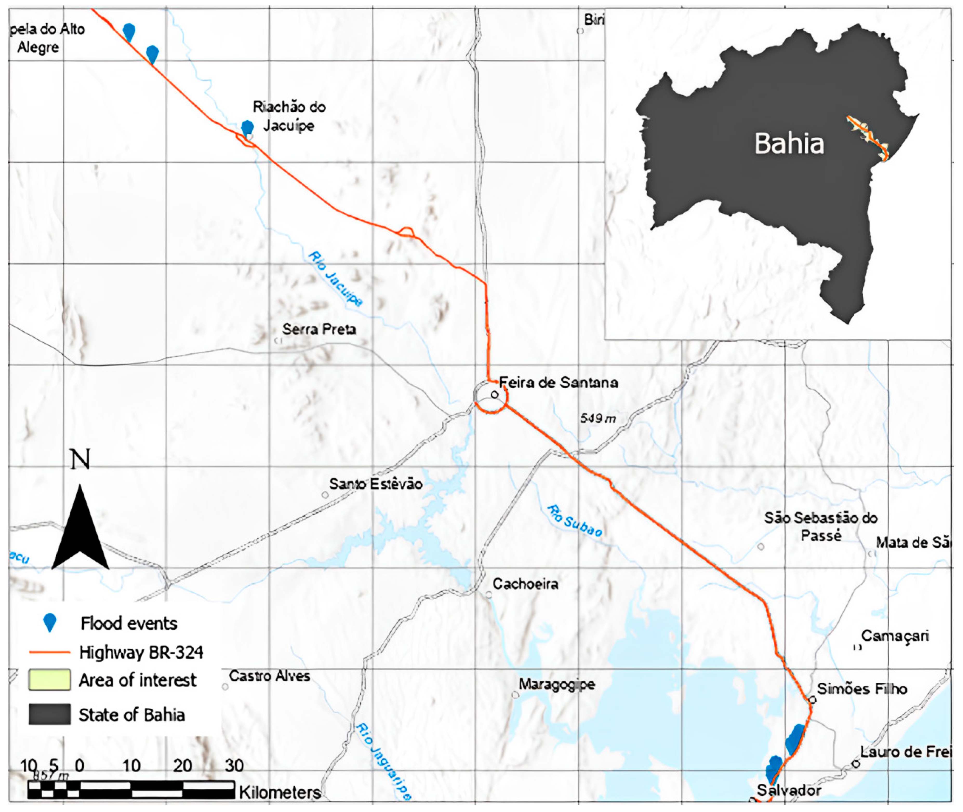
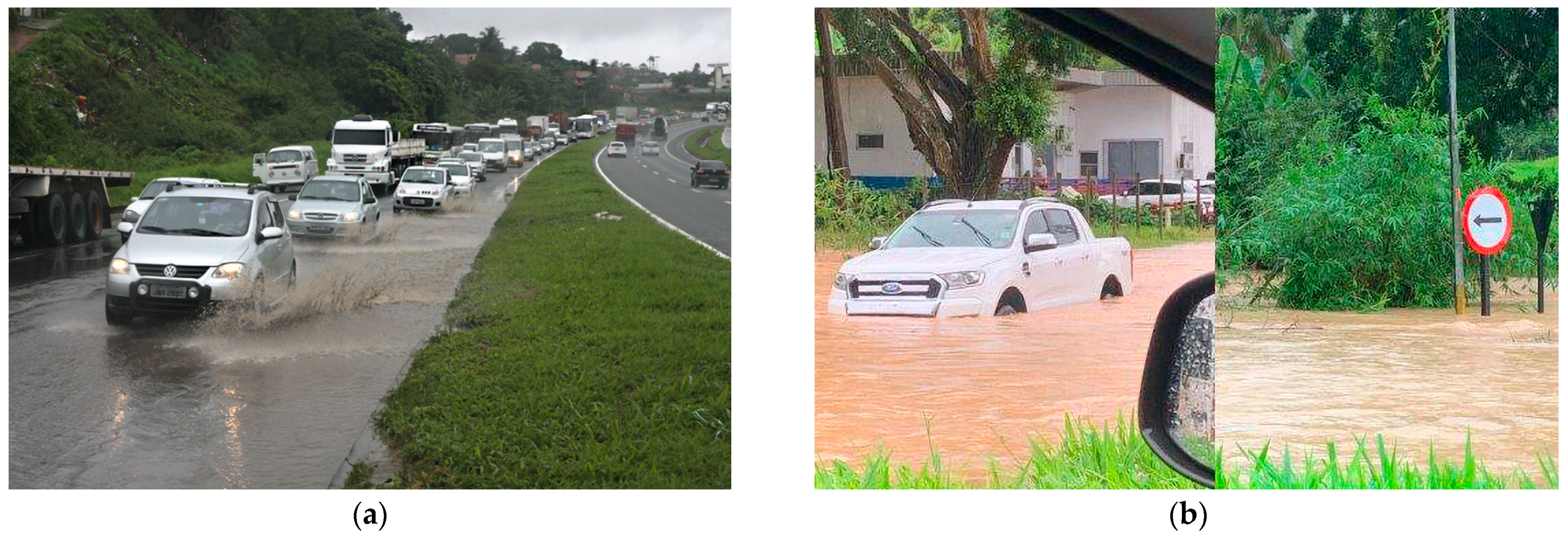
Effective risk management in road infrastructure, particularly when facing flash floods, requires an integrative approach that addresses the diverse and complex sources of uncertainty, adapts to specific project contexts, and promotes continuous learning and adaptation. This approach involves critically analyzing risk assessment tools, managing ambiguity, and enhancing resilience amidst project complexity. The aim is to improve the identification, assessment, and mitigation of risks, fostering adaptability and continuous learning in the sector. To integrate epistemology into road infrastructure risk management, particularly regarding flash floods, a questionnaire is proposed to guide engineers in validating identified and analyzed risks. This questionnaire focuses on critical questions that encourage reflection on the sufficiency of risk analysis, the existence of biases in risk formulation, and the adaptability of mitigation strategies to new knowledge or changing contexts. By continuously questioning the knowledge base and underlying assumptions, engineers can adopt a holistic and thoughtful approach to risk management, enhancing the project’s adaptability and resilience in the face of inherent uncertainties. The epistemological approach questionnaire, as shown in Table 3, promotes a culture of continuous improvement and learning within risk management in road infrastructure projects.

3.2. Case Study

The aim of this case study is to apply a combination of traditional quantitative and qualitative risk management approaches and epistemological concepts to the assessment of risks in road infrastructures. This analysis focuses on the risk of flooding. To exemplify the methodology, we adopted a case study. For this, we chose a national highway in Brazil with recurrent cases of flash flooding and its surroundings as the area of interest.
The study area (Figure 1) covers 5463.14 km2 across 11 municipalities in the state of Bahia. Bahia is the largest state in the Brazilian northeastern region in terms of land area, bordered by eight other states. The highways in Bahia play an important role in the country’s economy, being an obligatory route for the circulation of commodities for internal consumption and export. These include highway BR-324—the object of this case study [55].
BR-324 is a federal highway classified as diagonal, starting in the city of Balsas (state of Maranhão) and ending in Salvador (state of Bahia). In the state of Bahia, the road crosses a region of high population density and is used to access the state capital. One of the most important segments of the highway is from the city of Feira de Santana to Salvador, as in this segment, the BR-324 connects with the BR-116, BR-101 and BR-110. Its operation is co-managed by a private company and the National Department of Transport Infrastructure (DNIT). The total length of the BR-324 is 6807 km, and it is completely paved. All the sections in this study are on flexible pavement [55,56]. Nonetheless, this study analyzed 260.40 km of roadway, all of which is managed by a private company.
The area of interest is composed of two geographical mesoregions, the Centro Oeste Baiano (currently, this region is also known by Portão do Sertão) and the Metropolitan Region of Salvador. Of the eleven cities that comprise the target area, ten are located in the Centro Oeste Baiano. Portal do Sertão is part of the semi-arid region. Sub-humid to dry weather prevails in this region, with rainfall of up to 1000 mm, which occurs during the fall/winter periods in Brazil. The average annual temperature is around 24.2 °C. The topography is characterized by the so-called Sertaneja Depression, with the presence of slabs, rocky outcrops and temporary lakes. The residuals in the interplanaltic depressions are covered by hills and mountains. The plateau areas are located in the central and southeastern portions of the area, with altimetry of up to 400 m. On the other hand, in the metropolitan region of Salvador, a humid climate predominates, with a small humid to sub-humid band between the west of the municipality of Camaçari and part of the municipalities of Pojuca and São Sebastião do Passé. Rainfall is over 2000 mm, with heavy rains during the period between the beginning of March and the end of August, fall and winter in Brazil. The average annual temperature is around 24.8 °C. Red-Yellow Argisols are present in most of the territory. There are also spodosols, gleissols, latosols, neosols, organosols and vertisols. The territory’s contours are either made up of lowland areas, plateaus or depressions, as well as higher areas. It is worth noting that the city’s topography favored urbanization, and consequently, the implementation of road traffic precisely in the lower areas (avenues in the valley) [57,58,59].
The route between the two cities is extremely important for the country’s economy, as it is the principal logistical route on Brazil’s north–south axis. Strategic highways pass through the area, connecting the south coast, the center–south and the metropolitan region of Salvador to north, northeast and center–west regions of the country. According to government data [60,61,62], approximately 12,000 vehicles pass through the area every day, 60% of which are related to cargo transportation. Despite the importance of BR-324, factors such as insufficient maintenance, lack of adaptation measures and increased frequency of rainfall have made it extremely vulnerable to flooding. Table 4 summarizes the events recorded and published by DNIT in the last years [63].
The characteristics of the region’s topography, associated with climatic conditions, also facilitate the occurrence of flash floods in the region. Since 2011, there have been at least 11 traffic closures due to flooding on the BR-324 highway along the 108 km between Feira de Santana and Salvador. Some examples of flash floods on BR-324 are depicted in Figure 2.
The images presented provide a visual perspective of the traffic conditions on the BR-324 on days of heavy rain. Figure 2a, dated 9 November 2011, depicts a 5 km traffic jam in the direction of Feira de Santana, near the town of Águas Claras. Meanwhile, the second image (Figure 2b), captured on 7 April 2024, documents not only the congestion on the road towards Salvador but also the effects of flooding in the Simões Filho region, near the Federal Highway Police station. Despite the approximately 13-year gap between one situation and the other, the vulnerable situation of the highway has not been improved. These images provide important insights into traffic challenges on this road route caused by climate change.

4. Results

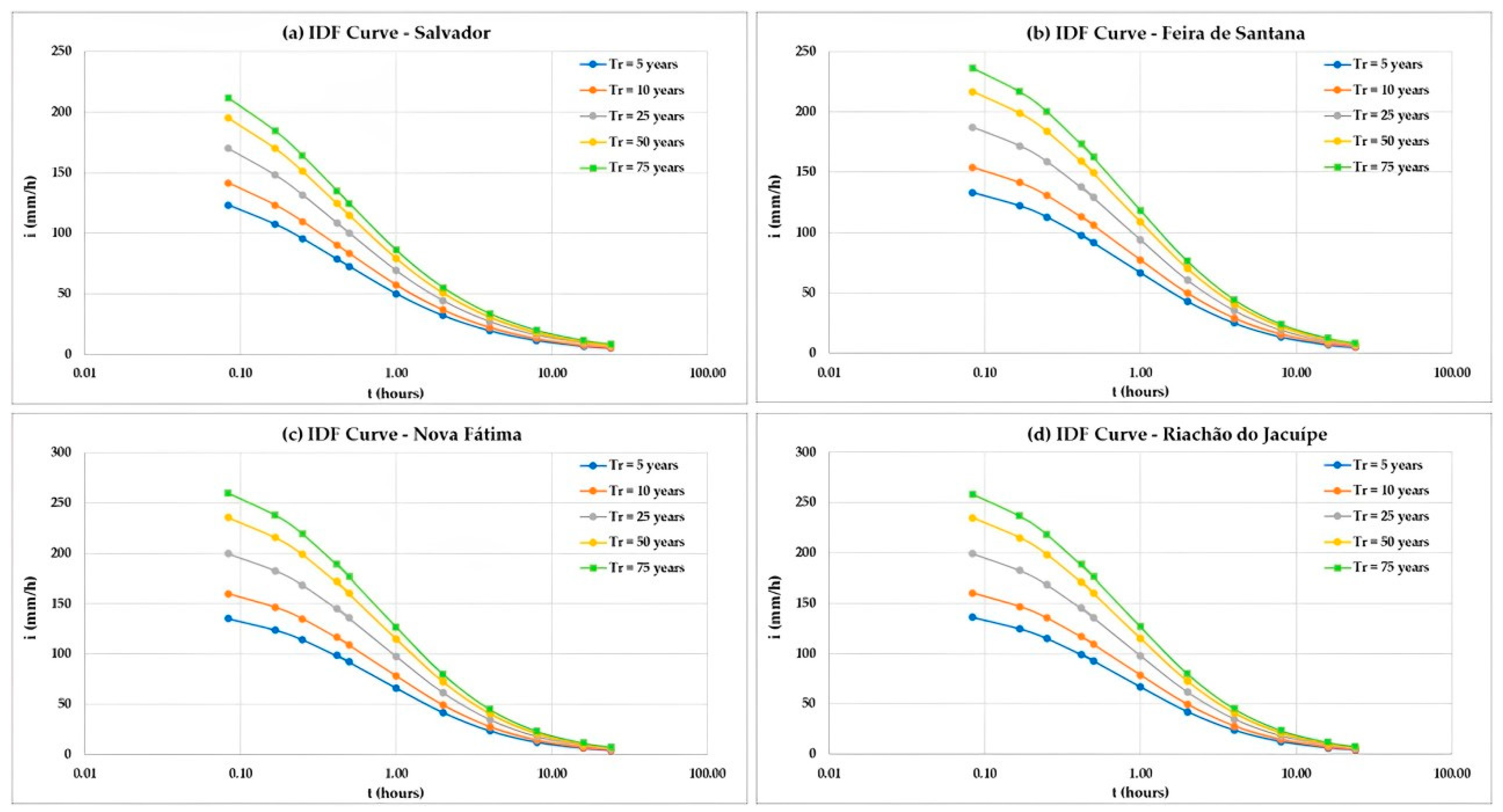
4.1. Rainfall Analysis

Construction of the BR-324 highway in Bahia started in the 1960s as part of the National Road Plan. The first segments were inaugurated at different times over the years. Specifically, the sections analyzed in this case study became operational in 1970. Therefore, in 2024, the highway will have been in operation for approximately 54 years The rainfall Intensity–Duration–Frequency (IDF) curves were calculated based on the historical rainfall data collected for the region of the BR-324 road sections in Bahia, and the coefficients are shown in Table 5 and Equation (2). Additionally, the IDF curves are depicted in Figure 3.
With regard to design aspects, the DNIT stipulates that road design in Brazil should take into account rainfall calculations for return times of 5 and 10 years [47]. The IDF curves are shown above. In this study case, we adopt different intervals to better understand the rainfall patterns considering the real road lifespan. Table 5 presents all IDF adjustment parameters used for calculating precipitation intensity in this research.
The IDF curves were estimated for the period from the start of operations of the stretches analyzed in 1970 to the present. These curves are essential for planning and sizing drainage and road infrastructure works, allowing for better preparation to deal with extreme rainfall events and ensuring the safety and efficiency of the road in the face of adverse weather conditions.
The precipitation data were obtained through remote sensing, using the Climate Hazards Group InfraRed Precipitation with Station (CHIRPS) database [64]. The CHIRPS dataset is based on intelligent interpolation techniques and high-resolution, long-period precipitation estimates using cold cloud duration (CCD) observations. The CHIRPS algorithm incorporates a 0.05° climatology that integrates satellite information to represent locations with few gauges, includes CCD-based daily and monthly precipitation estimates from 1981 to the present, and combines station data to produce a preliminary information product with a latency of around 2 days and a final product with an average latency of around 3 weeks. Table 6 provides the weighted average of accumulated precipitation during the days and the total accumulated in the respective months in which flash floods were recorded on the stretches of road studied.
Comparing the accumulated precipitation data on flood days with the data for the month, some interesting insights emerge. Firstly, it can be seen that the accumulated rainfall values on flood days tend to be significantly higher than the monthly average rainfall. This suggests that flood events are associated with periods of intense and concentrated rainfall over a short period of time. It is important to note that all cases of flooding, except for the case on 23/08/2011, were recorded outside the region’s rainy season, which is between March and August. A possible conclusion for this change in the pattern could be the change in the region’s climate pattern due to global warming.
Considering that the road sections analyzed are approximately 54 years old, the IDF curves show that the intensity of the first 5 min is in the 200–250 mm range in the study area. According to the IDF intensity curve equation (Equation (2)), the maximum rainfall value for 5 min for a return time (Tr) of 50 years was 235.73 mm in Nova Fátima. The analysis indicates that there is an increase in rainfall intensity of around 15% in the return time range between 5 and 10 years. In the Tr range of 50–75 years, the increase is 8% on average. Comparing the results of the IDF curves and the rainfall values recorded in Table 6, it is possible to conclude that the region between 410 km and 416 km is the most critical. On the other hand, the topography of the city of Salvador also turns the section between 617 km and 625 km extremely vulnerable to flooding. It is important to note that the design data for this highway are not available for analysis, which makes it impossible to analyze the drainage system in depth. However, it is worth questioning whether the BR-324 highway will be able to handle the intense frequency of rainfall in the region and the increase in the volume of precipitation. This highlights the importance of developing quantitative and qualitative measures to determine risk and adaptation to climate change.

4.2. Analysis of Underlying Causes and Response Strategies

The quantitative analysis of flood risks reveals significant rainfall intensities, particularly in the Nova Fátima region, where a maximum value of 235.73 mm was recorded for a 5 min duration with a 50-year return period. These data suggest that flash floods in this area are driven by extreme and concentrated rainfall events. The increase in rainfall intensity observed in the IDF curves—approximately 15% between 5 and 10 years return periods, and 8% between 50 and 75 years return periods—indicates a trend towards more frequent and severe flooding events. This intensification can be attributed to changes in regional climate patterns, potentially exacerbated by global warming.
The underlying causes of these flash floods are multifaceted. The significant increases in rainfall intensity and frequency, coupled with the aging infrastructure of the BR-324 highway, contribute to the heightened flood risk. Additionally, the insufficient capacity of existing drainage systems to handle increased water volumes during peak rainfall periods further exacerbates the risk of flooding. The topographical features of areas like Salvador, characterized by significant elevation changes, also play a critical role in directing water flow and increasing the vulnerability of certain road sections to flash flooding.
To develop more effective risk management strategies, it is essential to adopt both structural and non-structural measures. Structurally, upgrading and expanding the drainage infrastructure along critical sections of the highway can significantly reduce flood risks. Implementing permeable pavement systems and constructing retention basins are practical solutions that can help manage excess water during extreme rainfall events.
Non-structural strategies involve improving early warning systems and flood forecasting models. Utilizing real-time data from remote sensing technologies, such as the CHIRPS database, can enhance the accuracy of flood predictions and enable timely interventions. Additionally, incorporating an epistemological approach in risk management encourages continuous learning and adaptation. This involves regularly updating IDF curves and integrating new climate data to reflect current and projected rainfall patterns accurately.
Developing community engagement programs to educate local populations about flood risks and response measures is another critical component. By raising awareness and promoting proactive behaviors, communities can better prepare for and respond to flash flooding events, thereby mitigating the impacts on both human life and infrastructure.

5. Discussion

The integration of epistemological principles into construction risk management offers new insights into how engineers acquire, use, and validate knowledge to effectively navigate uncertainty, particularly in the context of road infrastructure facing flash floods. This review contextualizes these findings within the broader framework of the existing literature, revealing both convergences and divergences in approaches to managing uncertainty in construction projects.
Previous studies have often highlighted the static nature of risk management strategies that fail to adapt to the dynamic and complex environments typical of construction projects. In contrast, the epistemological approach advocated in this review promotes a more dynamic and reflective practice. This aligns with the views of those who argue for a reassessment of risk management as a knowledge-driven and iterative process. By embedding epistemological questioning into risk management processes, construction managers can elevate their strategic responses to both foreseen and unforeseen challenges, enhancing the adaptability and resilience of projects.
The implications of adopting an epistemological framework extend beyond mere methodology [65]. They touch upon the very ethos of engineering practice. Incorporating epistemological considerations encourages a culture of continuous learning and improvement—a sentiment echoed by who discusses the ethical dimensions of knowledge application in business and engineering. The rigorous validation of risk measures, a practice underscored by the unreliability of current methods, as discussed by experts, becomes not just a technical necessity but a moral obligation.
Furthermore, the findings from this review suggest several future research directions. For instance, there is a significant opportunity to explore how emerging digital technologies, such as artificial intelligence and machine learning, could be leveraged to enhance the epistemological bases of risk management. One author identifies this trend, noting the potential for intelligent risk management systems that could predict and mitigate risks in real time by continuously learning from data.
Despite the advancements that the epistemological approach proposes for construction risk management, it is important to acknowledge its inherent limitations. The primary constraint of this approach lies in its reliance on theoretical frameworks that may not fully capture the variability and complexity of real construction environments. Additionally, the application of epistemological principles might require a level of reflection and analysis that could be perceived as impractical in projects constrained by time and resources. Future research could focus on developing methods that integrate epistemological insights more efficiently and within tighter operational timelines. Moreover, exploring how emerging technologies such as artificial intelligence could automate some of this epistemological analysis presents a promising field to expand the applicability of the approach.
Additionally, considering the cultural and local context in risk management, as suggested by the findings, underscores the need for context-specific risk management frameworks. Future research could focus on developing localized risk management models that integrate epistemological principles tailored to specific environmental, socio-economic, and cultural contexts.
Risk management involves not only technical and economic considerations but also significant ethical and sustainability commitments. By adopting an epistemological approach, project managers have the responsibility to ensure that their decisions not only minimize risks but also promote practices that respect the rights and well-being of all stakeholders, including the community and the environment. This approach should consider how risk management decisions can influence environmental sustainability, ensuring that construction projects contribute to sustainable development goals. Future research should investigate how decisions based on deep and critical knowledge can effectively align with global ethical principles and sustainability practices, creating a framework that balances innovation, effective risk management, and social and environmental responsibility.
The integration of epistemological principles into risk management for road infrastructure, particularly in facing flash floods, reveals significant insights into how engineers can effectively navigate uncertainty. This review contextualizes these findings within the broader framework of the existing literature, identifying key areas where epistemological approaches enhance the management of flood risks.
Previous studies often highlight the static nature of traditional risk management strategies, which fail to adapt to the dynamic and complex environments of infrastructure projects, especially under the threat of flash floods [4,5]. In contrast, the epistemological approach advocated in this review supports a more dynamic and reflective practice. By embedding epistemological questioning into risk management, engineers can improve their strategic responses to both anticipated and unforeseen challenges, thereby enhancing the adaptability and resilience of road infrastructure facing flash floods. This aligns with the views of researchers who argue for a reassessment of risk management as a knowledge-driven and iterative process [10,11].
The specific impacts of flash floods on road infrastructure, such as pavement saturation, erosion, and structural damage, highlight the need for adaptive strategies. Incorporating epistemological principles enables a critical analysis of risk measures and allows for continuous updates based on new data and evolving conditions. For instance, the study demonstrates how high rainfall levels can overload drainage systems, leading to significant pavement deterioration. An epistemological framework facilitates a deeper understanding of these dynamics and the development of effective mitigation strategies.
The implications of adopting an epistemological framework extend beyond methodological considerations to influence the ethical and sustainability dimensions of engineering practice. Incorporating epistemological considerations fosters a culture of continuous learning and improvement, as highlighted by discussions on the ethical dimensions of knowledge application in engineering [9]. The rigorous validation of risk measures, underscored by the unreliability of current methods, becomes not just a technical necessity but a moral obligation [8].
Furthermore, the findings suggest several future research directions. There is significant potential to explore how emerging digital technologies, such as artificial intelligence and machine learning, can enhance the epistemological foundations of flood risk management. Intelligent risk management systems could predict and mitigate flood risks in real time by continuously learning from data, representing a promising advancement in the field [39,40]. The trend towards intelligent systems that can adapt to new information aligns with the need for dynamic risk management strategies [7].
Despite these advancements, it is important to acknowledge the inherent limitations of the epistemological approach. The primary constraint lies in its reliance on theoretical frameworks that may not fully capture the variability and complexity of real-world infrastructure environments. Additionally, the application of epistemological principles might require a level of reflection and analysis that could be impractical in projects constrained by time and resources. Future research should focus on developing methods that integrate epistemological insights more efficiently and within tighter operational timelines. Moreover, exploring how emerging technologies, such as artificial intelligence [66,67], could automate aspects of this epistemological analysis presents a promising avenue to expand the approach’s applicability.
Considering the cultural and local context in flood risk management, as highlighted by the findings, underscores the need for context-specific risk management frameworks [41,42]. Future research could focus on developing localized risk management models that integrate epistemological principles tailored to specific environmental, socio-economic, and cultural contexts.

6. Conclusions

The application of an epistemological approach to risk management significantly enhances decision-making processes, particularly in the context of road infrastructure facing flash floods. This study has demonstrated that integrating epistemological principles allows for a more nuanced understanding of uncertainty, promoting adaptive and reflective risk management practices.
By employing an epistemological framework, engineers can critically analyze and validate the knowledge used in risk assessments, which is crucial for improving the identification, assessment, and mitigation of risks associated with flash floods. The study’s findings highlight the importance of continuously updating risk measures to reflect new information and changing conditions, thereby enhancing the resilience and adaptability of infrastructure projects [68,69].
For instance, the analysis of the BR-324 highway in Brazil, a region prone to flash floods, revealed that rainfall intensities during flood events were significantly higher than monthly averages, with maximum values reaching 235.73 mm for a 5 min duration over a 50-year return period. This emphasizes the need for accurate and dynamic IDF and DDF curves to better predict and manage flood risks. The findings showed an increase in rainfall intensity of approximately 15% over 5 to 10 years and 8% over 50 to 75 years, highlighting the impact of climate change on rainfall patterns.
The epistemological approach also underscores the necessity of considering local and cultural contexts in risk management. Tailoring strategies to specific environmental and socio-economic conditions can enhance the effectiveness of risk management plans, ensuring they are more context-sensitive and sustainable. For example, the unique topography and climatic conditions of the study area contribute to the frequency and severity of flash floods, necessitating tailored risk management strategies that address these specific challenges.
Despite the benefits, this study acknowledges the limitations of the epistemological approach, such as its reliance on theoretical frameworks that may not fully capture real-world complexities and the potential impracticality of extensive reflection and analysis in time-constrained projects. Future research should focus on integrating epistemological insights more efficiently and exploring the use of emerging technologies like artificial intelligence to automate aspects of this analysis, enhancing the applicability and efficiency of risk management practices.

Author Contributions

Conceptualization, V.A.A.F. and F.O.d.S.; methodology, V.A.A.F. and F.O.d.S.; software, F.O.d.S.; validation, F.O.d.S. and S.O.; formal analysis, V.A.A.F. and F.O.d.S.; investigation, V.A.A.F. and F.O.d.S.; resources, V.A.A.F. and F.O.d.S.; data curation, F.O.d.S.; writing—original draft preparation, V.A.A.F.; writing—review and editing, F.O.d.S. and S.O.; visualization, V.A.A.F. and F.O.d.S.; supervision, F.O.d.S. and S.O.; project administration, V.A.A.F.; funding acquisition, V.A.A.F. All authors have read and agreed to the published version of the manuscript.

Funding

The APC was funded by Universidad Tecnológica del Perú and the consulting firm Ariza Ingenieros.

Data Availability Statement

The original contributions presented in the study are included in the article, further inquiries can be directed to the corresponding author.

Conflicts of Interest

The authors declare no conflict of interest.

References

  1. Allen, B.; Grogg, M.; Smith, K.; Pai, S. Improving the Link between Pavement Design and Asset Management: A Pavement Management Primer for Pavement Engineers; Applied Pavement Technology, Inc.: Urbana, IL, USA, 2022; S. FHWA-HIF-22-068. [Google Scholar]
  2. Akintoye, A.S.; MacLeod, M.J. Risk analysis and management in construction. Int. J. Proj. Manag. 1997, 15, 31–38. [Google Scholar] [CrossRef]
  3. Alkhawaja, A.S.I.; Varouqa, I.F. Risks management of infrastructure line services and their impact on the financial costs of road projects in Jordan. Meas. Sens. 2023, 25, 100647. [Google Scholar] [CrossRef]
  4. Malek, S.S.; Pathan, N.I.; Mal, H. Risk Management in Construction Industry. Indian J. Appl. Res. 2011, 3, 377–379. [Google Scholar] [CrossRef]
  5. Fevranoglou, G.; Diakaki, C. Risk management in construction projects: A study on the state-of-practice. Int. J. Decis. Sci. Risk Manag. 2019, 8, 197. [Google Scholar] [CrossRef]
  6. Myrczek, J.; Juraszek, J.; Tworek, P. Risk management analysis in construction enterprises in selected regions in Poland. Tech. Trans. 2020, 117, 1–13. [Google Scholar] [CrossRef] [PubMed]
  7. Osei-Kyei, R.; Narbaev, T.; Ampratwum, G. A Scientometric Analysis of Studies on Risk Management in Construction Projects. Buildings 2022, 12, 1342. [Google Scholar] [CrossRef]
  8. Baloyi, T.; Ozumba, A. Strategic Risk Management among Small Enterprises in the Construction Industry. MATEC Web Conf. 2020, 312, 02013. [Google Scholar] [CrossRef]
  9. Chenya, L.; Aminudin, E.; Mohd, S.; Yap, L.S. Intelligent Risk Management in Construction Projects: Systematic Literature Review. IEEE Access 2022, 10, 72936–72954. [Google Scholar] [CrossRef]
  10. Taleb, N.N. The Black Swan: The Impact of the Highly Improbable; Random House: New York, NY, USA, 2007; Available online: https://www.rh-newsletters.com (accessed on 11 March 2024).
  11. Lütge, C. Business Ethics and Risk Management; Springer: Dordrecht, The Netherlands, 2014; p. 43. [Google Scholar] [CrossRef]
  12. Hayes, M.V. On the epistemology of risk: Language, logic and social science. Soc. Sci. Med. 1992, 35, 401–407. [Google Scholar] [CrossRef]
  13. Hansson, S. The Epistemology of Technological Risk. SPT 2005, 9, 1–5. Available online: https://scholar.lib.vt.edu/ejournals/SPT/v9n2/hansson.html (accessed on 10 February 2024).
  14. Zheng, E.Z.H.; de Carvalho, M.M. Managing Uncertainty in Projects: A Review, Trends and Gaps. Rev. Gest. Projetos 2016, 7, 95–109. [Google Scholar] [CrossRef]
  15. Sahlin, U.; Helle, I.; Perepolkin, D. ‘This Is What We Don’t Know’: Treating Epistemic Uncertainty in Bayesian Networks for Risk Assessment. Integr. Environ. Assess. Manag. 2021, 17, 221–232. [Google Scholar] [CrossRef]
  16. Shome, N.; Rahnama, M.; Jewson, S.; Wilson, P. Quantifying Model Uncertainty and Risk. In Risk Modeling for Hazards and Disasters; Elsevier: Amsterdam, The Netherlands, 2018; pp. 3–46. [Google Scholar] [CrossRef]
  17. Migilinskas, D.; Ustinovicius, L. Methodology of risk and uncertainty management in construction’s technological and economical problems. In Proceedings of the 25th International Symposium on Automation and Robotics in Construction, Vilnius, Lithuania, 26–29 June 2008; Vilnius Gediminas Technical University Publishing House Technika: Vilnius, Lithuania, 2008; pp. 789–795. [Google Scholar] [CrossRef]
  18. Al Hasani, M.; Regan, M. Understanding Risk and Uncertainty Management Practice in Complex Projects. Eur. J. Econ. Law Polit. 2017, 4. [Google Scholar] [CrossRef]
  19. Beven, K.J.; Aspinall, W.P.; Bates, P.D.; Borgomeo, E.; Goda, K.; Hall, J.W.; Watson, M. Epistemic uncertainties and natural hazard risk assessment—Part 2: What should constitute good practice? Nat. Hazards Earth Syst. Sci. 2018, 18, 2769–2783. [Google Scholar] [CrossRef]
  20. Morales-Torres, A.; Escuder-Bueno, I.; Serrano-Lombillo, A.; Castillo Rodríguez, J.T. Dealing with epistemic uncertainty in risk-informed decision making for dam safety management. Reliab. Eng. Syst. Saf. 2019, 191, 106562. [Google Scholar] [CrossRef]
  21. Damnjanovic, I.; Reinschmidt, K. Data Analytics for Engineering and Construction Project Risk Management. In Risk, Systems and Decisions; Springer International Publishing: Texas, TX, USA, 2020. [Google Scholar] [CrossRef]
  22. Marshall, A.; Ojiako, U. Managing risk through the veil of ignorance. J. Risk Res. 2013, 16, 1225–1239. [Google Scholar] [CrossRef]
  23. Babic, B. A Theory of Epistemic Risk. Philos. Sci. 2019, 86, 522–550. [Google Scholar] [CrossRef]
  24. Covello, V.; Lave, L.; Moghissi, A.; Uppuluri, V. Uncertainty in Risk Assessment, Risk Management, and Decision Making; Springer US: Boston, MA, USA, 1987. [Google Scholar] [CrossRef]
  25. Engemann, K.J.; Miller, H.E.; Yager, R.R. A general methodology for decision making under uncertainty with a risk management application. In Proceedings of the 2nd International Symposium on Uncertainty Modeling and Analysis, College Park, MD, USA, 25–28 April 1993; IEEE Computers Society Press: Washington, DC, USA, 1993; pp. 194–199. [Google Scholar] [CrossRef]
  26. Richardson, J.G. The certainty of uncertainty: Risk management revisited. Foresight 2010, 12, 47–64. [Google Scholar] [CrossRef]
  27. Bevan, L.D. The ambiguities of uncertainty: A review of uncertainty frameworks relevant to the assessment of environmental change. Futures 2022, 137, 102919. [Google Scholar] [CrossRef]
  28. Bojórquez-Tapia, L.A.; Eakin, H.; Reed, P.M.; Miquelajauregui, Y.; Grave, I.; Merino-Benítez, T.; Molina-Pérez, E. Unveiling uncertainties to enhance sustainability transformations in infrastructure decision-making. Curr. Opin. Environ. Sustain. 2022, 55, 101172. [Google Scholar] [CrossRef]
  29. Itabashi-Campbell, R.; Gluesing, J.; Perelli, S. Mindfulness and product failure management: An engineering epistemology. Int. J. Qual. Reliab. Manag. 2012, 29, 642–665. [Google Scholar] [CrossRef]
  30. Kant, V.; Kerr, E. Taking Stock of Engineering Epistemology: Multidisciplinary Perspectives. Philos. Technol. 2019, 32, 685–726. [Google Scholar] [CrossRef]
  31. Rumpfkeil, M.P. Robust design under mixed aleatory/epistemic uncertainties using gradients and surrogates. J. Uncertain. Anal. Appl. 2013, 1, 7. [Google Scholar] [CrossRef]
  32. Cook, L.W.; Jarrett, J.P.; Willcox, K.E. Extending Horsetail Matching for Optimization Under Probabilistic, Interval, and Mixed Uncertainties. AIAA J. 2018, 56, 849–861. [Google Scholar] [CrossRef]
  33. Dantan, J.-Y.; Eifler, T. Integrated uncertainty management in parametric design and tolerancing. J. Eng. Des. 2021, 32, 517–537. [Google Scholar] [CrossRef]
  34. ISO 31000:2009; Risk Management—Principles and Guidelines. International Organization for Standardization: Geneva, Switzerland, 2009.
  35. Buchtik, L. Secretos para Dominar la Gestión de Riesgos en Proyectos; Buchtik Global: Montevideo, Uruguay, 2012. [Google Scholar]
  36. Guerrero-Aguiar, M.; Medina-Leon, A.; Nogueira-Rivera, D. Procedimiento de gestión de riesgos como apoyo a la toma de decisiones. Ing. Ind. 2019, 41, 1–14. [Google Scholar]
  37. Martinez Hernandez, R.; Blanco Dopico, M.I. Gestión de riesgos: Reflexiones desde un enfoque de gestión empresarial emergente. Rev. Venez. Gerenc. 2017, 22, 693–711. [Google Scholar] [CrossRef]
  38. Srinivas, K. Process of Risk Management. In Perspectives on Risk, Assessment and Management Paradigms; IntechOpen: London, UK, 2019. [Google Scholar] [CrossRef]
  39. Amuzu, J.; Jallow, B.; Kabo-Bah, A.; Yaffa, S. The climate change vulnerability and risk management matrix for the coastal zone of the Gambia. Hydrology 2018, 5, 14. [Google Scholar] [CrossRef]
  40. IPCC. Climate Change 2014: Synthesis Report. Contribution of Working Groups I, II and III to the Fifth Assessment Report of the Intergovernmental Panel on Climate Change; Cambridge University Press: Cambridge, UK, 2014. [Google Scholar]
  41. Thompson, P.B. The Philosophical Foundations of Risk. South J. Philos. 1986, 24, 273–286. [Google Scholar] [CrossRef]
  42. Doorn, N. Lotte Asveld and Sabine Roeser (eds), The Ethics of Technological Risk. Sci. Eng. Ethics 2009, 15, 259–261. [Google Scholar] [CrossRef]
  43. Lu, D. Pavement Flooding Risk Assessment and Management in the Changing Climate; University of Waterloo: Waterloo, ON, Canada, 2019. [Google Scholar]
  44. GPRH—Grupo de Pesquisa em Recursos Hídricos. Modelo Físico-Matemático para o Controle da Erosão Hídrica nas Condições Edafoclimáticas Brasileiras; Viçosa UFV: Viçosa, Brazil, 2008; p. 78. Available online: http://www.gprh.ufv.br/?area=modelo_fisico_matematico (accessed on 3 March 2024).
  45. United Nations International Strategy for Disaster Reduction (UNISDR). The Human Cost of Weather-Related Disaster 1995–2005. Available online: https://www.preventionweb.net/publications/view/46796 (accessed on 8 April 2024).
  46. Little, D.N.; Jones, D.R.J. Moisture Sensitivity of Asphalt Pavements; University of California: Berkeley, CA, USA, 2003. [Google Scholar]
  47. Brasil; Departamento Nacional de Infra-Estrutura de Transportes; Diretoria de Planejamento e Pesquisa; Coordenação Geral de Estudos e Pesquisa; Instituto de Pesquisas Rodoviárias. IPR Publ. 724. In Manual de Drenagem de Rodovias, 2nd ed.; DNIT: Rio de Janeiro, Brazil, 2006; p. 333. [Google Scholar]
  48. Vuong, B. Influence of density and moisture content on dynamic stress-strain behaviour of a low plasticity crushed rock. Road Transp. Res. 1992, 1, 88–100. [Google Scholar]
  49. Shahin, M.Y. Pavement Management for Airports, Roads, and Parking Lots, 2nd ed.; Springer: New York, NY, USA, 2005. [Google Scholar]
  50. Labi, S.; Sinha, K.C. Life-cycle evaluation of flexible pavement preventive maintenance. J. Transp. Eng. 2005, 131, 744–751. [Google Scholar] [CrossRef]
  51. Kırbaş, U. IRI Sensitivity to the Influence of Surface Distress on Flexible Pavements. Coatings 2018, 8, 271. [Google Scholar] [CrossRef]
  52. Sayers, M.W.; Gillespie, T.D.; Queiroz, C.A.V. The International Road Roughness Experiment: Establishing Correlation and a Calibration Standard for Measurements; The World Bank: Washington, DC, USA, 1986; p. 454. [Google Scholar]
  53. Qiao, Y.; Chen, S.; Alinizzi, M.; Alamaniotis, M.; Labi, S. Estimating IRI Based on Pavement Distress Type, Density, and Severity: Insights from Machine Learning Techniques. 2021. Available online: https://arxiv.org/abs/2110.05413 (accessed on 9 March 2024).
  54. Brasil; Departamento Nacional de Infra-Estrutura de Transportes; Diretoria de Planejamento e Pesquisa; Coordenação Geral de Estudos e Pesquisa; Instituto de Pesquisas Rodoviárias. IPR Publ. 720. In Manual de Restauração de Pavimentos Asfálticos, 2nd ed.; DNIT: Rio de Janeiro, Brazil, 2005; p. 310. [Google Scholar]
  55. IBGE—Brazilian Institute of Geography and Statistics. Available online: https://biblioteca.ibge.gov.br/index.php/biblioteca-catalogo?view=detalhes&id=429061 (accessed on 25 April 2024).
  56. DNIT—National Department of Transportation Infrastructure. Available online: https://servicos.dnit.gov.br/vgeo/ (accessed on 25 April 2024).
  57. Brasil; Ministério de Minas e Energia; Departamento Nacional da Produção Mineral; Projeto Radam Brasil. Folhas SD.24 Salvador: Geologia, Geomorfologia, Pedologia, Vegetação e Uso Potencial da Terra; DNPM: Rio de Janeiro, Brazil, 1981; Levantamento de Recursos Naturais, 24.
  58. Brasil; Ministério de Minas e Energia; Departamento Nacional da Produção Mineral; Projeto Radam Brasil. Folhas SD.23 Brasília: Geologia, Geomorfologia, Pedologia, Vegetação e Uso Potencial da Terra; DNPM: Rio de Janeiro, Brazil, 1982; Levantamento de Recursos Naturais, 29.
  59. Bahia; Secretaria do Planejamento; Secretaria do Meio Ambiente. Zoneamento Ecológico-Econômico Preliminar; SEPLAN; SEMA: Salvador, Brazil, 2013.
  60. Andrade, A.B.; Brandão, P.R.B. Geografia de Salvador, 2nd ed.; EDUFBA: Salvador, Brazil, 2009; p. 160. ISBN 978-85-232-0564-5. [Google Scholar]
  61. BRASIL, Governo Federal. Available online: https://www.gov.br/pt-br/noticias/transito-e-transportes/2021/04/duplicacao-de-22-km-da-br-101-e-entregue-na-bahia (accessed on 26 March 2024).
  62. Pereira, A.; Oliveira, F. A Via Portuária de Salvador: Mobilidade na Capital Baiana a Partir de Intervenções Viárias. Cad. Metrópole 2013, 15, 535–556. [Google Scholar] [CrossRef]
  63. De Sousa, F.O. Hazroad-monitoring system for hazard prevention in highways-a case study in Brazilian federal highways, 27th World Road Congress, 2023 Prague, Czech Republic. 2023. Available online: https://www.road.or.jp/english/img/piarc/LMICs.pdf (accessed on 29 April 2024).
  64. Funk, C.; Peterson, P.; Landsfeld, M.; Pedreros, D.; Verdin, J.; Shukla, S.; Michaelsen, J. The Climate Hazards Infrared Precipitation with Stations—A New Environmental Record for Monitoring Extremes. Sci. Data 2015, 2, 150066. [Google Scholar] [CrossRef]
  65. Althaus, C.E. A Disciplinary Perspective on the Epistemological Status of Risk. Risk Anal. 2005, 25, 567–588. [Google Scholar] [CrossRef]
  66. Limo, F.A.F.; Tiza, D.R.H.; Roque, M.M.; Herrera, E.E.; Murillo, J.P.M.; Huallpa, J.J.; Gonzáles, J.L.A. Personalized tutoring: ChatGPT as a virtual tutor for personalized learning experiences. Przestrz. Spoleczna 2023, 23, 292–312. [Google Scholar]
  67. Huallpa, J.J. Exploring the ethical considerations of using Chat GPT in university education. Period. Eng. Nat. Sci. 2023, 11, 105–115. Available online: https://orcid.org/0000-0003-4067-2816 (accessed on 10 February 2024).
  68. Ariza Flores, V.A.; Portocarrero, E. Integrating Resilience in Construction Risk Management: A Case Study on Peruvian Road Infrastructure. E3S Web Conf. 2024, 497, 02019. [Google Scholar] [CrossRef]
  69. Ariza Flores, V.A.; Salvador, R. Adaptive Risk Management in Road Construction: Oyon-Ambo Highway Insights, El Niño 2019 Case Study. E3S Web Conf. 2024, 497, 02020. [Google Scholar] [CrossRef]
Figure 1. Location of the 5463.14 km2 study area along the BR-324 highway State of Bahia in Brazil, with manually mapped floods.
Buildings 14 01931 g001
Figure 2. Floods in the area of interest. (a) Photo depicting a 5 km traffic jam on the BR-324 towards Feira de Santana, in the Águas Claras city, dated 9/11/2011. (Credits: https://bahianoar.com (accessed on 26/04/2024)). (b) Image capturing traffic congestion and blockage of the BR-324 highway towards Salvador on 07/04/2024. The flooding in the Simões Filho region near the Federal Highway Police checkpoint. (Credits: https://aratuon.com.br/ (accessed on 27/04/2024)).
Buildings 14 01931 g002
Figure 3. Rainfall intensity curves for the study area for return times of 5, 10, 25, 50 and 75 years. (a) In the top left corner, the IDF curves for the city of Salvador. (b) In the top right corner, the IDF curves for the city of Feira de Santana. (c) In the bottom left corner, the IDF curves for the city of Nova Fátima. (d) In the bottom right corner, the IDF curves for the city of Riachão do Jacuípe. The time axis is in the logarithm scale.
Buildings 14 01931 g003
Table 1. Risk matrix.
LikelihoodImpact
MinorModerateMajorSevereCatastrophic
RareLowLowLowLowLow
UnlikelyLowLowMediumMediumMedium
PossibleLowMediumMediumHighHigh
LikelyLowMediumHighHighExtreme
Almost CertainLowMediumHighExtremeExtreme
This risk matrix assesses the likelihood and impact of potential adverse events. Each cell combines these dimensions to prioritize risks based on their potential severity. The color green defines a low-risk assessment, yellow a medium-risk assessment, and red a high or extreme risk assessment. Terms such as ‘Low’, ‘Medium’, ‘High’, ‘Extreme’ are defined according to organizational risk management standards and may vary by project specifics. A detailed review of identified risks is recommended to determine appropriate mitigation measures.
Table 2. Pavement surface condition—Brazilian method.
ConceptIRI (m/km)PCI
Excellent1.0–1.95–4
Good1.9–2.74–3
Regular2.7–3.53–2
Poor3.5–4.62–1
Very Poor>4.61–0
This table is an adaptation of the table presented in the Asphalt Pavement Restoration Manual of the Brazilian National Department of Transportation Infrastructure (DNIT). The Table shows the levels of concepts attributable to and relating to pavement surface conditions according to the subjective assessment and the corresponding ranges of values for the main Indices/Parameters used in the Objective Assessment. In the Brazilian method, the PCI scale ranges from 0 to 5, with 0 being very poor and 5 being excellent. See reference [54].
Table 3. Epistemological approach questionnaire for flash flood risk management in road infrastructure.
AspectQuestion
Risk IdentificationWhat methods have been used to identify risks related to flash floods?
Have previous experiences and expert knowledge on flash floods been considered in identifying risks?
Have all potential sources of risk, including those internal and external to the road infrastructure project, been explored?
Risk AnalysisHow have the identified risks from flash floods been quantified or qualified?
Have flash flood risks been assessed based on their likelihood of occurrence and potential impact?
Have contextual and cultural factors, particularly those related to flash flood-prone areas, been considered in the risk analysis?
Risk Response PlanningHave mitigation, transfer, acceptance, or avoidance strategies been developed for the identified flash flood risks?
How will response strategies adapt if flash flood conditions or the environment change?
Risk Monitoring and ControlWhat mechanisms are in place to monitor flash flood risks throughout the road infrastructure project?
How will the risk management plan be updated in the face of new knowledge or changes in flash flood conditions?
Sustainability AssessmentHow do the planned risk mitigation strategies for flash floods impact environmental sustainability?
What measures are in place to ensure that sustainability goals (such as reduced carbon footprint, minimal waste, etc.) are not compromised in the face of flash flood risks?
Epistemological ReflectionAre there assumptions or biases that might have influenced flash flood risk identification and analysis?
Has an environment been fostered that allows for questioning and critically reviewing the assumptions underlying flash flood risk management?
How do you incorporate new knowledge or technological advances into the management of flash flood risks in road infrastructure projects?
How do you critically assess the validity and reliability of information used in managing flash flood risks?
This questionnaire is designed to guide engineers in applying an epistemological approach to risk management in road infrastructure projects facing flash floods. By encouraging critical reflection on risk identification, analysis, response planning, monitoring, control, and sustainability, the questionnaire aims to enhance the adaptability, resilience, and overall effectiveness of risk management strategies.
Table 4. Flooding on the BR-324 between Salvador and Feira de Santana.
DateSection (km)MunicipalityLongitudeLatitude
09/04/2010617Salvador−38.438097−12.886053
14/04/2010616Salvador−38.432163−12.879618
23/08/2011615Feira de Santana−38.427477−12.872084
09/11/2011622Salvador−38.464935−12.918797
09/11/2011624Salvador−38.471872−12.933742
09/11/2011614Salvador−38.423701−12.863979
19/12/2014416Nova Fátima−39.550888−11.681749
19/12/2014410Nova Fátima−39.591691−11.643446
04/01/2016622Salvador−38.464935−12.9188
04/01/2016625Salvador−38.470833−12.94188
22/01/2016438.9Riachão do Jacuípe−39.38542−11.81236
The records were made by DNIT and published on the agency’s social networks. See reference [63].
Table 5. Coefficients of IDF Curve.
MunicipalityKabc
Salvador1288.5000.20022.0000.810
Feira de Santana5853.3670.21251.8231.021
Nova Fátima8614.9150.24155.4851.107
Riachão do Jacuípe8263.0360.23755.0351.096
IDF curve adjustment parameters. All these parameters were obtained from the Plúvio 2.1 software, which consists of a hydrological database of Brazilian cities. See reference [44].
Table 6. Flood records information.
DateSection (km)MunicipalityPrecipitation
Accumulated
Day (mm)
Total Accumulated in the Month (mm)
09/04/2010617Salvador339.811090.81
14/04/2010616Salvador102.10
23/08/2011615Feira de Santana73.81307.92
09/11/2011614–622–624Salvador74.75400.22
19/12/2014410–416Nova Fátima195.004706.85
04/01/2016622–625Salvador245.37745.99
22/01/2016438.9Riachão do Jacuípe74.29
IDF curve adjustment parameters. All these parameters were obtained from the Plúvio 2.1 software, which consists of a hydrological database of Brazilian cities. See references [44,63].
Disclaimer/Publisher’s Note: The statements, opinions and data contained in all publications are solely those of the individual author(s) and contributor(s) and not of MDPI and/or the editor(s). MDPI and/or the editor(s) disclaim responsibility for any injury to people or property resulting from any ideas, methods, instructions or products referred to in the content.

