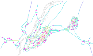
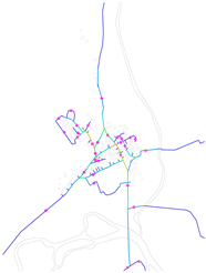
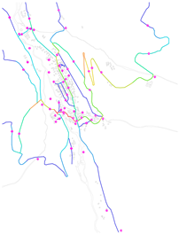
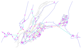
Abstract
Nomadic heritage villages constitute significant material cultural heritage. Under China’s cultural revitalization and rural development strategies, these villages face spatial degradation driven by tourism and urbanization. Current research predominantly employs isolated analytical approaches—space syntax often overlooks social dynamics while social network analysis (SNA) overlooks physical interfaces—hindering the development of holistic solutions for socio-spatial resilience. This study proposes a multi-scale integrated assessment framework combining social network analysis (SNA) and space syntax to systematically evaluate public space structures in traditional nomadic villages of Xinjiang. The framework provides scientific evidence for optimizing public space design in these villages, facilitating harmonious coexistence between spatial functionality and cultural values. Focusing on three heritage villages—representing compact, linear, and dispersed morphologies—the research employs a hierarchical “village-street-node” analytical model to dissect spatial configurations and their socio-functional dynamics. Key findings include the following: Compact villages exhibit high central clustering but excessive concentration, necessitating strategies to enhance network resilience and peripheral connectivity. Linear villages demonstrate weak systemic linkages, requiring “segment-connection point supplementation” interventions to mitigate structural elongation. Dispersed villages maintain moderate network density but face challenges in visual integration and centrality, demanding targeted activation of key intersections to improve regional cohesion. By merging SNA’s social attributes with space syntax’s geometric precision, this framework bridges a methodological gap, offering comprehensive spatial optimization solutions. Practical recommendations include culturally embedded placemaking, adaptive reuse of transitional spaces, and thematic zoning to balance heritage conservation with tourism needs. Analyzing Xinjiang’s unique spatial–social interactions provides innovative insights for sustainable heritage village planning and replicable solutions for comparable global cases.
1. Introduction
1.1. Background
Rural areas serve as fundamental components of social systems by providing agricultural communities with both material infrastructure and socio-cultural frameworks, thereby forming the foundation for agricultural economic development [1]. Heritage villages represent culturally significant human habitats that preserve generational architectural characteristics while maintaining living cultural practices [2,3,4]. These settlements embody substantial tangible and intangible cultural heritage value, functioning not only as public space networks that sustain rural social relations but also as engines for sustainable rural development [5,6]. Furthermore, as strategic assets, traditional villages effectively address practical challenges in sustainable tourism development while advancing contemporary rural revitalization initiatives [7].
However, the accelerated urbanization process across China has triggered large-scale rural reconstruction projects, resulting in significant alterations to traditional village architectural structures and, in severe cases, irreversible damage [8]. This predicament stems from an overemphasis on modernizing material infrastructure while neglecting balanced development between social institutional frameworks and cultural heritage preservation. Such development patterns have generated three core issues: compromised spatial integrity, degradation of vernacular landscapes, and intensified rural population outflow. These problems have further eroded villagers’ sense of identity and belonging toward rural public spaces. In preserving traditional villages and their cultural heritage, spatial morphology serves as a crucial medium for sustaining regional culture [9,10]. The spatial form of traditional villages is collectively shaped by overall spatial layout, architectural spaces, and street network configurations [11,12]. Morphological studies provide fundamental foundations for conservation and development planning of traditional villages [13]. Among these elements, village public spaces—encompassing street networks and communal architectural areas—function simultaneously as social arenas for community interaction and primary physical vessels for traditional culture [14]. Materially, they constitute the fundamental framework for production and daily life; culturally, they evolve into tangible containers of collective memory, acting as vital catalysts that stimulate and sustain village vitality.
As an important branch of urban morphology research, the spatial morphology analysis of heritage villages has a long academic tradition. Historical records indicate that scholarly investigation of settlement patterns can be traced back to Kohl’s pioneering 1841 study, which examined the relationship between village morphology and topographic characteristics [15]. A landmark contribution to settlement morphology came from A. Meitzen (1895), who conducted systematic field investigations of agricultural communities in northern Germany, establishing a comprehensive classification system encompassing spatial layouts and morphological features [16]. However, current research on heritage village morphology remains predominantly focused on descriptive analysis, typological classification, and explanatory frameworks, neglecting more rigorous quantitative approaches [10,12,13]. These qualitative studies demonstrate limitations in systematically analyzing the complex spatial structures and organizational logic of traditional settlements [17,18]. The development of robust quantitative methods capable of decoding the inherent spatial logic of heritage villages has become an urgent research challenge in contemporary academia. Furthermore, against the backdrop of accelerating urbanization, planning interventions frequently disregard these settlements’ unique indigenous attributes. Consequently, such transformations have triggered fundamental changes in architectural forms and spatial layouts, gradually marginalizing traditional villages within modern development paradigms [19].
Nomadic heritage villages represent multidimensional cultural heritage and landscapes in postmodern society, embodying unique nomadic civilizations [20]. These settlements integrate cultural, ecological, social, and economic values, serving as repositories of both cultural heritage preservation and ecological wisdom [21]. However, globalization and urbanization have led to the decline of nomadic lifestyles, exposing these villages to dual challenges of intensified settlement and ecological degradation. In China, nomadic settlements constitute vital components of the nation’s “pluralistic unity” cultural framework. Investigating these communities not only enhances understanding of Chinese civilization’s diverse characteristics but also provides sustainable development pathways for rural revitalization in ethnic border regions. Xinjiang, located at the crossroads of Eastern and Western cultural exchange, preserves nomadic communities that serve as crucial carriers of Silk Road intangible cultural heritage [22]. Studying and protecting their public spaces promotes harmonious coexistence among Xinjiang’s ethnic groups while holding profound significance for cultural heritage conservation.
1.2. Literature Review
Early international research on heritage villages primarily focused on settlement geography, analyzing spatial layouts [23], forms, and structures of settlements [24]. In recent years, quantitative studies of villages have begun to emerge. Current academic research on village morphology primarily employs technologies such as GIS analysis and space syntax for quantification.
- (1)
- Space Syntax
Space syntax theory originated from the pioneering research of Bill Hillier and his team at University College London’s Bartlett School of Architecture in the 1970s, developing into a comprehensive framework for spatial quantification and organizational pattern analysis [10,25,26]. This methodology, later refined by scholars including Julienne Hanson, systematically examines the fundamental relationships between spatial configuration and social function through pattern recognition and structural characterization [11,27,28]. International applications in rural studies primarily focus on analyzing village morphology and architectural layouts to identify influencing factors and inform spatial development strategies. Researchers have employed sociological frameworks to study interactions between residential spaces and social structures. For example, Décio Rigatti and Elio Trusiani applied space syntax theory and techniques to analyze rural housing samples in Italy before and after immigration, inferring their connections to social structures [29]. Other scholars have focused on the spatial organization and layout patterns of rural dwellings and entire villages. Kim Yun Song et al. evaluated and interpreted the spatial structural features of Hanok villages using space syntax metrics, reflecting on the rationality of village layouts [30]. Hamed Beyti and colleagues utilized space syntax methodology to analyze the spatial configuration of vernacular dwellings in East Azerbaijan Province, demonstrating the applicability of this analytical framework to rural settlement morphology [31], while Sonay Ayyıldız and Şahin Durak utilized space syntax theory to analyze the spatial structure of heritage rural houses in Yalova, discussing their cultural relationships [32]. Some researchers have further extended their investigations by proposing strategies to address existing issues based on analyses of rural spatial morphology. For example, Yim Hee-young and colleagues integrated space syntax methodology to analyze the spatial configuration of Winnipeg’s Central Village in Canada, with the objective of mitigating the ongoing erosion of rural community identity [33]. Meanwhile, China has made significant breakthroughs in quantitative research on heritage villages. Cui Kai et al. established an objective evaluation system based on space syntax, eliminating subjective factors, and used multi-source data with correlation analysis to explore vitality factors in historic districts [34]. Gao Chenge et al. analyzed 33 heritage villages along the Yellow River in western Shanxi, constructing spatial axis models with space syntax and applying K-Prototype clustering to classify spatial structural attributes [35]. Tang Tianpeng et al. integrated GIS and space syntax to develop a “space-society” framework for identifying, optimizing, and verifying spatial forms in historic districts [36].
- (2)
- Social Network
Traditional quantitative methods for heritage analysis increasingly demonstrate limitations in addressing modern societal complexities, particularly regarding inadequate social dimension integration and fragmented spatial analysis [19]. This gap has stimulated global applications of social network theory in architectural and planning research. Emerging from British anthropology during the 1930s–1960s and maturing in subsequent decades, social network analysis has yielded significant practical applications: For example, social network analysis has enabled researchers to enhance and improve urban spatial environments [19]. It has also guided public participation in the spatial transformation of old communities and informed studies on urban road scales. Additionally, it has been used to optimize urban environments for adult activity needs [37], analyze multi-scale urban accessibility [38], and support renewal projects in commercial and historic districts [39]. In Auckland, New Zealand, social network analysis explored the regional characteristics of urban center public spaces [40], while, in Bucharest, it assessed the coordination between public spaces and activities [41]. In Ethiopia, scholars used social network analysis to reveal multi-level urban network structures, guiding public space development to meet community needs [42]. Chinese scholars have applied social network analysis to various fields, including urban villages [43], residential communities [44], commercial districts [45], and ancient villages [46,47]. These applications employ spatial-visualization techniques to derive evidence-based optimization strategies that align physical configurations with human behavioral patterns.
- (3)
- Renovation Study of Village Public Space
In rural public space research, some scholars have adopted spatial evaluation approaches. Barbora Lipovská et al. assessed rural public space usage from a landscape design perspective [48], while Dawid Soszyński proposed evaluation methods for rural landscape spaces to guide transformation processes [49]. Other studies have employed case-specific spatial analyses to demonstrate public space significance and provide improvement strategies. Agnieszka Jaszczak et al. examined Poland’s “Rural Revival Program” in Warmia-Masuria, suggesting methods for landscape project coordination, evaluation criteria refinement, and community engagement [50]. Dawid Soszyński et al. combined expert studies, interviews, and surveys to analyze four representative villages in eastern Poland, emphasizing the role of public spaces [51]. Several international scholars have integrated spatial justice theory to explore innovative approaches for spatial renewal. For instance, Purcell demonstrates how neoliberal urban commodification violates the ‘right to the city,’ necessitating participatory planning to restore democratic urban governance [52]. Soja conceptualizes spatial inequality as core to social inequity, advocating grassroots resistance to hegemonic spatial practices for fairer urban development [53].
In China, early rural public space research focused on sociological aspects, defining scopes and compositions [54]. Wu Yi categorized public spaces into elementary, institutional, political, and informal types [55]. Wang Chunguang’s case study of Village J in Anshun, Guizhou, explored spatial functions and compositions to address western rural development issues [56]. Subsequent studies examined evolutionary processes to trace the formation and reconstruction of rural order, alongside practical explorations of public space construction pathways [57]. Anan Zhang et al. employed Lefebvre’s theory of space production, utilizing structured questionnaires and the statistical analysis software SPSS 24.0 to quantitatively assess the adaptability of resettled villagers across three dimensions: physical space, institutional space, and social space [58].
1.3. Research Gaps and Contributions
The synthesis and comparison presented in Table 1 reveal two significant limitations in current quantitative research on public spaces within heritage villages. First, existing research predominantly examines spatial morphological characteristics within individual villages, lacking comparative analyses across multiple villages or regions [55,56]. Second, comprehensive multi-level quantitative approaches—particularly those employing exterior-to-interior and macro-to-micro analytical frameworks—remain underdeveloped in heritage village studies. Geographically, Chinese scholarship demonstrates notable regional disparities. While quantitative research on heritage villages and public space optimization concentrates in eastern coastal areas, studies of ethnic minority villages primarily focus on Hunan, Yunnan, and Guizhou provinces [51,57,59]. This distribution leaves Xinjiang’s heritage villages substantially underrepresented in current academic discourse. Through systematic literature analysis, this study identifies three critical research gaps:
- Narrow perspectives: Heritage studies relying solely on space syntax as a quantitative method tend to focus exclusively on street network characteristics while neglecting the relationship between streets and surrounding elements, particularly overlooking how villagers’ behaviors interact with and influence public spaces.
- Geographical imbalance: Research on ethnic minority villages in Xinjiang remains scarce, with existing studies disproportionately concentrated in Hami, Turpan, and Changji regions, leaving quantitative studies on heritage villages in Yili and Aletai prefectures virtually unexplored.
- Typological bias: Current heritage village research predominantly examines agricultural and coastal fishing villages, with inadequate attention given to nomadic settlement studies.
To address these knowledge gaps, this study proposes the following innovative contributions:
- Expanded analytical framework: The analytical framework has been significantly expanded through the integration of diverse spatial datasets across urban and rural contexts. The developed multidimensional social network models successfully capture structural characteristics of various social network patterns, while simultaneously providing reliable references for regional planning and development initiatives.
- Geographical and typological diversity: The research addresses critical geographical and typological gaps by focusing on three nomadic tourism heritage villages in northern Xinjiang. This approach not only fills the quantitative research void regarding ethnic minority villages in Xinjiang, but also pioneers visual analysis techniques for nomadic settlements. Comparative analysis of villages with distinct spatial configurations yields both differential assessments and practical optimization strategies.
- Multi-scale indicator system: Integrating social network analysis (SNA) with space syntax, along with ArcGIS (v10.8) spatial analysis tools and virtual boundary scale theory, a three-tier “village territory–street network–node” analytical framework is established.
This study employs a multi-scale indicator framework to conduct a scientific quantitative analysis of public spaces in nomadic heritage villages and proposes targeted optimization strategies. The approach aims to prevent blind renovation and ineffective construction caused by unilateral tourism capital encroachment. Villagers, as the primary stakeholders, should maintain dominance over public spaces during village transformation. By respecting the endogenous cultural logic of villages, this method helps prevent cultural distortion resulting from tourism development. Furthermore, the study thoroughly examines how spatial practices of different groups intersect, assimilate, or conflict due to varying spatial needs. This analysis ensures spatial equity, coordinates resident-visitor interactions, promotes sustainable cultural-tourism integration, and ultimately achieves a positive interplay between heritage conservation and tourism development.
2. Materials and Methods
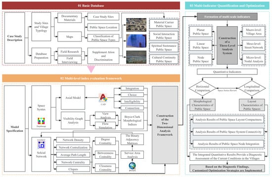
Building upon these identified research gaps, the present study establishes an integrated quantitative analysis framework for examining spatial morphological patterns in heritage villages, as systematically outlined in Figure 1. This analytical framework comprises three fundamental components.
The components are as follows:
- Case Study Description: Through literature review and field investigations, the study locations and public space distributions within each village were identified. Fundamental data collection established a foundational database for subsequent model development.
- Multi-level Index Evaluation Framework: Integrating social network analysis with space syntax, the framework simultaneously generates space syntax axial models and social network spatial models. This integration addresses the limitations of space syntax through social network complementarity. Employing virtual boundary scale theory, planar closed shapes of settlement boundaries were created to facilitate space syntax visibility graph analysis. Combined with GIS, this approach enables a comprehensive examination of public space structural characteristics in northern Xinjiang’s tourism-oriented heritage nomadic villages.
- Multi-Indicator Quantification and Optimization: Adopting a “point-line-plane” spatial perspective, the analysis system evaluates three hierarchical levels—village territory, street, and nodes. The comparative analysis employs dual methodological approaches to examine public space characteristics. Horizontal comparisons elucidate typological patterns across varying village scales, whereas vertical comparisons assess morphological differences in three key dimensions: spatial layout density, systemic connectivity, and nodal integration levels. Subsequently, all quantitative analysis results are consolidated, and targeted optimization strategies are formulated based on the findings.
Based on literature research and field investigations, this study conducts a quantitative analysis of clustered, linear, and dispersed village patterns by constructing space syntax and social network models. According to the quantitative parameters, the morphological characteristics of public spaces and the structural features of public space layouts in different village types are identified. The parameters are then diagnostically evaluated (the criteria for each indicator are presented in Table 3) to identify issues in the public spaces of each village type, thereby providing targeted optimization recommendations for subsequent improvements.
2.1. Case Study Description
2.1.1. Study Sites and Village Typology
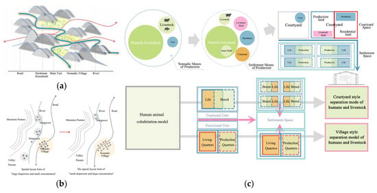
In China’s nomadic villages, traditional migratory, temporal, seasonal living patterns and spatial mobility have been replaced by settled communities due to rural revitalization. The nomadic production mode has been most severely impacted by modern urbanization, with traditional yurts gradually being substituted by log-cabin dwellings, which to some extent represent the new-era residential mode of China’s nomadic groups [60]. This study focuses on the public spaces of heritage villages in Xinjiang, primarily because existing research on heritage villages has generally paid insufficient attention to this region. Xinjiang and Inner Mongolia are the two main nomadic distribution areas in China. And Nomadic villages in Xinjiang are predominantly concentrated in the northern region, specifically distributed across the Altai Mountains, the northern foothills of the Tianshan Mountains, and the transitional zone of the Junggar Basin. Although significant transformations have occurred in the livelihood and production modes of Xinjiang’s nomadic villages, their spatial organization remains profoundly influenced by natural geographical conditions and nomadic production practices. This is evident in village site selection, settlement composition, and spatial layout patterns, which differ distinctly from agricultural and fishing villages (Figure 2). Moreover, the street network morphology of nomadic villages demonstrates distinct characteristics compared to traditional agricultural or fishing villages, primarily due to variations in mountainous and riparian environments. Their social structures demonstrate greater stability owing to the collective and mutually supportive nature of nomadic economies—key distinguishing factors in village morphology [61]. With the influence of rural tourism, these nomadic villages have gradually shifted from traditional pastoral livelihoods to tourism-based economies. Non-permanent structures like yurts are now primarily preserved for symbolic significance rather than practical use.
Figure 2.
Spatial characteristics of nomadic villages. (a) Schematic diagram of site selection and layout of nomadic villages; (b) transformation of the spatial layout of pastoral villages in the lower reaches in the new era; (c) schematic diagram of settlement spatial layout change under the transformation of means of production.
Given these distinctive characteristics, this study adopts Jiang et al.’s methodology (illustrated in Figure 3), generating settlement boundary polygons using 100 m virtual buffer zones to classify boundary morphologies of northern Xinjiang’s nomadic heritage villages [62]. The results reveal three predominant morphological types: compact, linear, and dispersed (Figure 4).
Figure 3.
Illustration of virtual boundary extent. (a) Illustration of virtual boundary extent of Talat; (b) illustration of virtual boundary extent of Qiongkushitai; (c) illustration of virtual boundary extent of Hemu.
Figure 4.
Settlement typology. (a) Settlement typology of Talat; (b) settlement typology of Qiongkushitai; (c) settlement typology of Hemu.
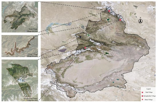
In selecting case study villages, primary consideration was given to their inclusion in China’s Heritage Villages Catalog. Additionally, given Xinjiang’s location on China’s northwestern frontier and its abundant tourism resources, the region has experienced rapid tourism development under the guidance of the “Cultural Nourishment of Xinjiang” initiative and the “Tourism Revitalization of Xinjiang” strategy. Rural tourism plays a pivotal role in poverty alleviation through employment generation and rural revitalization. Against this backdrop, examining the spatial effects of tourism development on Xinjiang’s villages holds significant importance for promoting tourism-driven rural revitalization. Consequently, selection criteria incorporated factors such as transportation infrastructure and tourism development maturity. Based on these considerations, the study selected Talat, Qiongkusitai, and Hemu Village as representative cases of the three morphological types. All three are key national rural tourism villages with high population concentration and relatively complete public space systems. The morphological analysis focuses exclusively on the core residential areas of nomadic villages in northern Xinjiang, as their boundaries encompass extensive pastoral lands with few permanent structures. The locations of the three studied villages are specified in Figure 5.
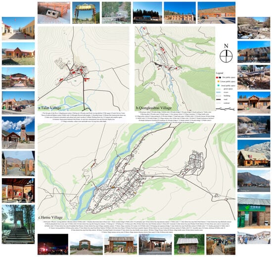
Field investigations revealed that Hemu and Talat Villages have largely modernized road systems, whereas Qiongkusitai Village maintains predominantly unpaved roads. Notably, Talat Village contains numerous cul-de-sacs that ensure residential privacy but result in fragmented connectivity and an incomplete street network. The master plans of the three villages and photographs of their typical public spaces are shown in Figure 6.
2.1.2. Data Preparation
The study first preliminarily identified the locations of village public spaces using maps and the literature and then supplemented and verified these findings through field surveys combined with interviews with village committees, residents, and tourists. The public spaces were categorized into three types: points, lines, and areas. Furthermore, by overlaying activity types onto these three spatial categories and analyzing the interrelationships between various activities and spaces, they were ultimately classified into four distinct types (Table A1 of Appendix A).
2.2. Multi-Level Index Evaluation Framework:
This research utilizes an integrated approach combining social network analysis with space syntax theory to systematically evaluate both physical spatial configurations (in-cluding settlement boundaries, street networks, and nodal hierarchies) and corresponding sociocultural requirements (Table 2). Corresponding analytical models were constructed, including an axial map, visibility graph analysis, and spatial domain network model.
2.2.1. Construction of Axial Model and Visibility Analysis Scope
The study begins by employing CAD technology to convert the three villages into recognizable graphics in Depthmap+ Beta 1.0 (v2012). These graphics are then imported into Depthmap+ to construct an axial model (Figure 7), which facilitates the analysis of the villages’ street-scale and linear spatial characteristics. This model also serves as the foundation for quantifying the villages’ intelligibility and axial connectivity values. Additionally, in Section 2.1.1, the research integrates the villages’ visual boundaries (Figure 3) with their road networks to define the scope for visual analysis [63].
2.2.2. Spatial Domain Network Modeling
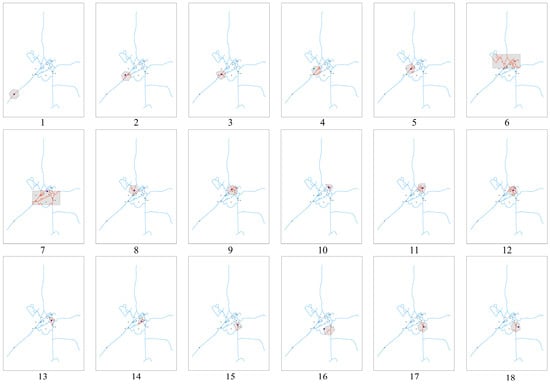
Each existing public space within the villages was treated as a node. A direct, unobstructed path between two nodes—without intervening nodes or alternative paths—was defined as an edge and assigned a value of 1; otherwise, the value is 0 [64]. A street network dataset was constructed in GIS, and service area analysis layers were created. As this step primarily served as an intermediate phase for modeling village spatial domains, only Talat Village—characterized by fewer nodes—was selected for detailed analysis, while other villages were omitted for brevity. Given the small scale of the target villages, edge distances were set within a walkable range (70–120 m), with a 1 min walking distance (120 m) established as the threshold for determining node connectivity. Accessible areas are represented by shaded regions and red road lines in Figure A1 of Appendix A, where nodes within these ranges were considered interconnected. The binary adjacency matrices of the three villages (Figure A3 of Appendix A) were processed in UCINET 6.0, and the computational results were visualized using NETDRAW (v2.1) to construct a topological network model of spatial domains for nomadic tourism-oriented heritage villages in Northern Xinjiang (Figure 8).
2.3. Multi-Indicator Quantification and Optimization
This research adopts a multi-scale analytical approach, examining three spatial hierarchies—village territory, street networks, and nodal points—through comparative analysis of different settlement types. The methodology integrates “point-line-plane” spatial relationships across macro, meso, and micro-levels of investigation. This analysis reveals the public spatial morphological characteristics of each village type: (1) macro-scale and “areal” spatial features, in which space syntax analysis evaluates visibility graph analysis (VGA) and intelligibility to assess both the overall visibility of public spaces and the correlation between part and whole of the village; (2) meso-scale and “linear” spatial features, in which global integration, local integration, and choice metrics from space syntax are visualized in diagnostic models to evaluate the existing road networks; and (3) micro-scale “point-like” spatial features, in which social network analysis, including clique analysis and network density, is applied alongside a weighted node-scale visualization model to identify core nodes and key intersections within each network. Detailed evaluation criteria for each metric are provided in Table 3.
Next, the study conducts a vertical comparison of public space layouts across different villages, focusing on layout compactness, system connectivity, and node integration: (1) layout compactness of public spaces, which is evaluated using three metrics—including network density and network centralization—with villages ranked based on their respective values; (2) system connectivity of public spaces, which is assessed through average path length, integration, and axial connection, with villages ranked accordingly and in which visualization models of axial connection are further compared with integration values to identify discrepancies; and (3) node integration of public spaces, which is measured via network centrality metrics to determine which types of public spaces (classified in Table 2) occupy core positions in each village’s network.
Building upon these horizontal and vertical comparisons, the study synthesizes the findings and proposes differentiated optimization strategies for each public space type, informed by spatial justice theory.
3. Results
The results are divided into two subsections:
- (1)
- Morphological Characteristics Results:
This section systematically examines the public spatial configurations of heritage villages across distinct morphological typologies and multiple scales. The analysis employs a tripartite spatial framework encompassing “point-line-plane” elements to systematically examine settlement patterns at three levels: overall village configuration, linear transportation networks, and nodal spatial arrangements. This approach reveals distinct structural characteristics across different village morphologies at varying scales.
- (2)
- Comparative Analysis of Indicators Results:
This section conducts a systematic comparative examination of three critical spatial parameters across the studied village typologies: settlement density, network permeability, and focal point centrality. Through this tripartite analytical framework, the study elucidates fundamental morphological distinctions in the spatial organization of heritage settlements with varying formal characteristics.
- (3)
- Comparison of simulated flow and actual behavior:
The research identifies discrepancies between simulated high-traffic areas and actual public space allocation through comparative analysis of pedestrian flow simulations and behavioral observations at core nodes. These findings serve dual purposes: informing optimal placement of future public spaces while verifying the consistency between simulated and empirical usage patterns in existing village public areas.
3.1. Characteristics of Public Spaces in Heritage Villages Across Different Dimensions
3.1.1. Macro-Scale and “Areal” Spatial Features
The research applies space syntax analysis using intelligibility and visual integration metrics to quantitatively examine the axial model constructed in Section 2.2.1 and the visibility boundaries of village territories. This analytical method diagnoses the overall visibility characteristics of different village types (Figure 9) and examines the correlation between the part and whole of the village (Figure 10). The results reveal macro-scale structural features of the villages.
- (1)
- Compact Village (Talat Village)
Figure 9.
Visibility graph analysis (VGA). (a) VGA of Talat; (b) VGA of Qiongkushitai; (c) VGA of Hemu.
Figure 10.
Intelligibility visualization diagram. (a) Intelligibility visualization diagram of Talat; (b) intelligibility visualization diagram of Qiongkushitai; (c) intelligibility visualization diagram of Hemu.
The overall visibility in Talat Village is relatively good, with visual integration decreasing from the core village area toward the periphery. Except for a few branch roads far from the main village area, which appear dark blue (indicating poor visibility), the visual integration of public spaces is generally acceptable. In terms of intelligibility, Talat village demonstrates an R2 value of 0.266, falling within the 0.2–0.4 range. This indicates a moderate correlation between the part and whole of the village, suggesting that, while the settlement requires partial exploration for comprehensive understanding, it remains fundamentally navigable.
- (2)
- Linear Village (Qiongkushitai Village)
Qiongkushitai Village exhibits relatively high overall visibility, with the linear core area and most public spaces demonstrating superior visual integration. This characteristic stems from the village’s simple spatial configuration, primarily structured along the Ancient Wusun Trail. However, the intelligibility value measures 0.188, below the 0.2 threshold, indicating weak correlation between the part and whole of the village and potential wayfinding difficulties.
- (3)
- Dispersed Village (Hemu Village)
The overall visibility in Hemu Village is suboptimal, with almost no areas exhibiting high visual integration. The primary factor contributing to this phenomenon relates to the dispersed spatial arrangement of buildings characteristic of this settlement type. The intelligibility analysis yields an R2 value of 0.205, falling within the 0.2–0.4 range, which indicates a moderate correlation between the part and whole of the village.
3.1.2. Street Scale and Linear Spatial Characteristics
A quantitative analysis was conducted on the axial model constructed in Section 2.2.1, yielding analytical results regarding street-scale characteristics in Table 4. The study employs R = 3 as the default parameter for local integration in space syntax analysis, which calculates topological depth within three steps from each node. This parameter selection represents an optimal balance between spatial cognition theory and empirical evidence, effectively capturing the locality of human spatial behavior while maintaining computational efficiency. As an established empirical constant in space syntax research, the R = 3 parameter demonstrates optimal explanatory power across most application scenarios [59,65,66,67].
- (1)
- Compact Village (Talat Village)
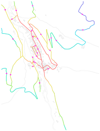
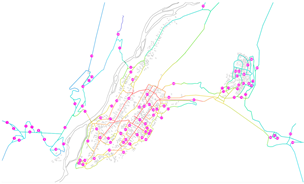
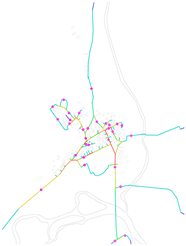
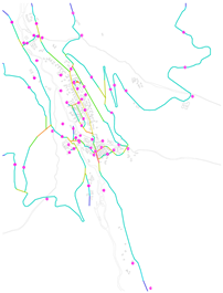
Talat Village features a cross-shaped road network formed by two main roads leading to Koktokay Town and the Koktokay Scenic Area. The local integration core of Talatt Village is concentrated on Roads 3, 21, 24, 25, and 27, with the Tourist Center and the gate of “First Village along the Ertix River” serving as the central blocks, gradually decreasing outward. This indicates a strong capacity for attracting pedestrian flow, making it the primary space for visitor circulation within the village. However, the global integration core is only found on Roads 2 and 7, failing to fully cover the key tourist areas. Notably, Road 27, which serves as the only access route to the Koktokay Scenic Area, should have been a high global integration zone. However, due to insufficient connectivity with the rest of the village, its accessibility is poor, making it easily overlooked by tourists. The choice values of streets and alleys across the village are generally low, with only localized areas on Roads 2, 8, and 25 showing relatively higher values.
- (2)
- Linear Village (Qiongkushitai Village)
The settlement of Qiongkushitai Village follows the course of the Qiongkushitai River, with its main thoroughfare—the ancient Wusun Trail (Road 2)—running longitudinally through the entire village. Syntactic analysis reveals this primary artery and exhibits the highest global integration value, a characteristic consistent with the typical morphological features of linear settlement patterns. The high global integration values in Qiongkushitai Village are concentrated on Roads 2, 8, 10, 13, 14, 15, 16, 17, 18, and 19, which consist of the primary thoroughfare and its connecting roads. The core architectural area of the village demonstrates good global integration, whereas local integration is only high in a small section of Road 15, with other areas showing low values. This may be attributed to the Qiongkushitai River running through the village, where the water body acts as a barrier, and the presence of bridges reduces spatial accessibility, necessitating optimization of local road networks. The global choice values are also very low, with only small open spaces showing relatively higher values. The overall traffic conditions in the village remain poor, particularly for Roads 13, 14, 17, 18, and 19, which have high global integration but low choice values. Future optimization efforts should focus on adding nodes along these roads to enhance pedestrian flow.
- (3)
- Dispersed Village (Hemu Village)
Hemu Village consists of a circular main road in the old village and connecting branch roads linking the old and new villages. The high global integration values in Hemu Village are concentrated on Roads 13, 26, 32, 59, 60, 61, and 67, with the highest value located on the village shuttle loop (Road 26). The analytical results align with the actual village conditions, confirming this area as a significant overlap zone between tourist and resident circulation patterns. However, local integration is only high in the eastern section of the village loop (Road 26), while other areas exhibit low values. The choice values indicate that the shuttle loop and the main entrance road for shuttles (Road 65) have relatively high choice values, which is consistent with the village’s real-world conditions.
3.1.3. Node Scale and Point-Type Spatial Characteristics
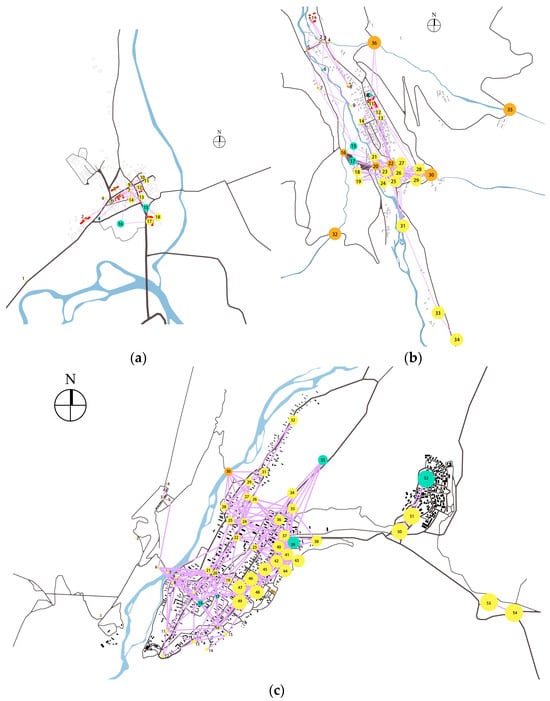
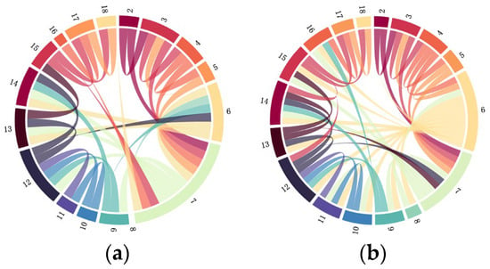
The spatial domain network model from Section 2.2.1 was transformed with weighted proportions to visualize the ratio of each node in the network (Figure 11). The weights of each node in the network were further quantified, and cliques were divided using at least three spatial nodes as the criteria to further identify key nodes in the spatial network. The clique distribution is illustrated in Figure 12, with detailed distribution data provided in Table A2 of Appendix A.
- (1)
- Compact Village (Talat Village)
Figure 11.
Visualization network of weighted proportions in spatial domain network models. (a) Visualization network of weighted proportions in the spatial domain network model of Talat; (b) visualization network of weighted proportions in the spatial domain network model of Qiongkushitai; (c) visualization network of weighted proportions in the spatial domain network model of Hemu.
Figure 12.
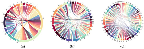
The clique distribution. (a) The clique distribution of Talat; (b) the clique distribution of Qiongkushitai; (c) the clique distribution of Hemu.
The public space network model of Talat Village contains 12 cliques. The gate of the First Village (Node 1) did not form any clique due to its distance from other nodes in the village. According to the spatial network diagram, the spatial layout is relatively compact, and Node 1 has no connections with other nodes. Larger nodes indicate a more central position in the network. Nodes 15, 16, 17, and 18 occupy the core positions of the village, clustered around the Village Committee (Node 17).
- (2)
- Linear Village (Qiongkushitai Village)
The public space network model of Qiongkushitai Village contains 21 cliques. Among them, Nodes 32, 33, 34, and 35 did not form any cliques. Despite lacking connections to other nodes, nodes 32 and 35 maintain significant importance within the network as crucial junction spaces facilitating both intra-village and external transportation.
- (3)
- Dispersed Village (Hemu Village)
The public space network model of Hemu Village contains 40 cliques, which are numerous and scattered. Nodes 1, 2, 14, 53, and 54 did not form any cliques, consistent with the characteristics of a dispersed village. The public space network model of Hemu Village consists of 40 spatially distributed clusters. Nodes 1, 2, 14, 53, and 54 remain unclustered, exhibiting relatively even weighted distributions that align with the village’s dispersed settlement pattern. This spatial configuration reflects two characteristic behaviors: residents demonstrate purpose-driven mobility with minimal cross-regional commuting, while tourists primarily rely on shuttle services to access distributed public spaces despite their spatial separation.
3.2. Comparative Analysis Results of Hierarchical Indicators for Heritage Villages with Different Morphologies
The study examines indicators across different hierarchical levels of villages with varying morphologies to identify characteristic public space structures for each settlement type.
3.2.1. Analysis of Public Space Layout Compactness
Network density serves as a metric for evaluating the completeness of nodal connections within villages, primarily reflecting the compactness of their current spatial layouts. This research utilizes network density and centralization metrics from social network analysis to assess public space layout compactness (Table 5). The comparative analysis yields three key findings: First, Hemu Village’s dispersed structure achieves optimal public space network density. Second, Talat Village’s compact block pattern demonstrates intermediate density performance. Third, Qiongkushitai Village’s linear configuration results in the lowest density values. Notably, compact villages exhibit superior network centrality characterized by three distinct advantages: balanced spatial distribution, pronounced central tendency, and well-defined core areas—all significantly outperforming linear and dispersed settlement types.
3.2.2. Connectivity Analysis of Public Space Systems
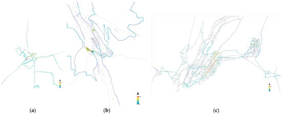
The study employs the average shortest path from social network analysis and the integration (Table 6) and axial connectivity metrics from space syntax to examine the connectivity between public space systems (Figure 13).
Figure 13.
Axial connectivity value. (a) Axial connectivity value of Talat; (b) axial connectivity value of Qiongkushitai; (c) axial connectivity value of Hemu.
The comparative analysis yields four principal findings:
First, global integration follows a clear hierarchy: compact (Talat Village) > dispersed (Hemu Village) > linear (Qiongkushitai Village) settlements. But, local integration values show another pattern: dispersed > compact > linear configurations.
Second, axial connectivity visualization (warm colors indicating higher values) reveals distinct spatial patterns: Hemu Village maintains strong correlation between axial connectivity and integration. Talat Village shows minor divergence, with peak connectivity at the village square rather than the higher-choice Road No. 2. Qiongkushitai Village displays marked discrepancies, with only Node 17—the transitional space between two bridges—exhibiting both high integration and connectivity due to obligatory pedestrian congregation
Third, average path length values demonstrate the following: linear > compact > dispersed sequences. In public space networks, a smaller average shortest path signifies fewer intermediary steps in spatial node connections, while a larger value indicates more transitions.
Fourth, Node 17 in Qiongkushitai Village illustrates a critical spatial transition mechanism. Located between two bridges, this node serves as a transitional zone where movement converts from two linear spaces to a planar space. The forced passage through this constrained area induces temporary pedestrian congregation, consequently generating a localized high-connectivity hotspot despite the overall system’s limitations.
3.2.3. Integration Analysis of Public Space Nodes
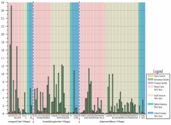
This research evaluates spatial node utilization preferences through network centrality metrics, where higher values correspond to greater usage frequency and preference. The comparative analysis (Figure 14) yields three key findings:
First, Talat Village demonstrates pronounced spatial preferences: material-carrier public spaces show significantly higher centrality than other types. Node 7 exhibits exceptional betweenness centrality, indicating network dominance.
Second, significant disparities exist between peripheral and core areas in terms of degree centrality and betweenness centrality, whereas closeness centrality remains relatively uniform. This pattern indicates strong village-wide cohesion in the public spaces of compact settlements.
Third, comparative village analyses show the following: Qiongkushitai Village demonstrates higher centrality values in social interaction spaces, particularly at bridge nodes 5 and 7 that connect river-divided areas. This pattern underscores the critical function of connective spaces in facilitating movement between distinct zones of linear settlements. In contrast, Hemu Village exhibits elevated centrality in material-transport spaces, with all nodes showing more balanced centrality distributions and no conspicuously dominant nodes.
3.3. Comparison of Simulated Flow and Actual Behavior
The research integrates visibility analysis (Section 3.1.1) with pedestrian flow simulation to establish a simplified movement model. This model is subsequently validated against actual movement patterns obtained through behavioral mapping and participatory diagramming, thereby identifying underutilized spatial zones within the village settlement.
3.3.1. Pedestrian Flow Simulation
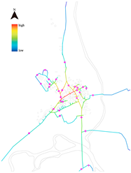
Figure 15 presents the quantitative analysis results of pedestrian flow behavior simulation.
- (1)
- Compact Village (Talat Village)
Figure 15.
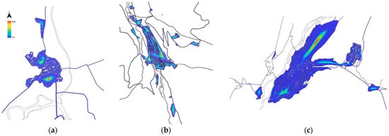
Pedestrian flow simulation. (a) Pedestrian flow simulation of Talat; (b) pedestrian flow simulation of Qiongkushitai; (c) pedestrian flow simulation of Hemu.
Pedestrian flow simulations in Talat Village demonstrate that highly visible public spaces do not correspond to areas of highest pedestrian density, contrary to theoretical expectations. This discrepancy primarily results from the combination of narrow alleyways and numerous cul-de-sacs, which collectively reduce visual permeability by disrupting spatial continuity. Field observations validate these findings, showing that the village’s most densely populated areas coincide with distinct seasonal leisure activities during both winter and summer months. These results confirm the effectiveness of the spatial design in successfully concentrating pedestrian flows and achieving its intended functional objectives.
- (2)
- Linear Village (Qiongkushitai Village)
The pedestrian flow simulation incorporating visibility analysis demonstrates that the highest pedestrian concentrations in Qiongkushitai Village occur along its primary thoroughfares, a pattern corroborated by field investigations. Significantly, the village’s existing public spaces are predominantly situated within these high-traffic zones, confirming a strong alignment between simulated and empirically observed movement patterns.
- (3)
- Dispersed Village (Hemu Village)
The integrated visibility analysis and pedestrian flow simulation for Hemu Village reveal that simulated pedestrian density peaks in the Hongbasa Grassland scenic area. However, field observations indicate an absence of public spaces in the southern village sector where the simulation predicts high pedestrian flows.
3.3.2. Construction of Behavioral Networks
The study developed two social behavior networks within the village socio-spatial model described in Section 2.2.2: a villager behavior network diagram (Figure 16) and a tourist behavior network diagram (Figure 17). The villager behavior network integrates field-observed activity patterns with the socio-spatial network. Similarly, the tourist behavior network combines participatory mapping data with the socio-spatial network. In both networks, node size directly corresponds to visitation frequency, with isolated nodes indicating rarely visited locations. A comparative analysis of these networks reveals shared spatial usage between villagers and tourists, along with patterns of interaction, adaptation and potential conflict in their use of public spaces. This approach provides clear evidence of how different user groups occupy and move through the heritage village environment. The methodology employs straightforward network visualization techniques where larger nodes represent more frequented areas and unconnected nodes show underutilized spaces. By examining the overlap and divergence between the villager and tourist networks, the study identifies key patterns in spatial behavior that inform heritage management strategies.
- (1)
- Comparison between villager behavior network and tourist behavior network
Figure 16.
The villager behavior network diagram. (a) The villager behavior network diagram of Talat; (b) the villager behavior network diagram of Qiongkushitai; (c) the villager behavior network diagram of Hemu.
Figure 17.
The tourist behavior network diagram. (a) The tourist behavior network diagram of Talat; (b) the tourist behavior network diagram of Qiongkushitai; (c) the tourist behavior network diagram of Hemu.
The analysis reveals distinct spatial usage patterns between villagers and tourists across the three studied villages. In Talat Village, villagers predominantly frequent nodes 13, 15, 16, and 17, while tourists concentrate around nodes 10 through 18, with shared nodes 13, 15, 16, and 18. Qiongkushitai Village shows villager activity concentrated at nodes 27 through 31 and 36, contrasting with tourist presence at nodes 27, 28, 30, 31, 33, and 34, sharing nodes 28, 30, and 31. Hemu Village demonstrates villager preference for nodes 36 through 52, while tourists utilize a broader range from 38 through 54, with shared nodes 39 through 44 and 51 through 52.
Comparative network analysis indicates that Talat Village’s public spaces predominantly cater to tourist needs and usage patterns. This tourism-centric design approach has progressively undermined the village’s communal character, frequently resulting in tensions between local residents and visitors. In contrast, Qiongkushitai and Hemu Villages maintain more balanced shared usage patterns, where most nodes serve both populations, potentially fostering greater social cohesion between villagers and visitors.
- (2)
- Comparison between the actual behavior node network and the flow simulation
The study integrates villager and tourist behavioral patterns with their corresponding spatial locations (Figure 18) and compares them with pedestrian flow simulations from Section 3.3.1, identifying underutilized spaces to inform targeted optimization strategies. In Talat Village, the simulation reveals two high-traffic areas: the primary one coincides with the shared core node 16, while the secondary area lacks designated public spaces. This finding suggests creating villager-specific spaces in the secondary high-traffic zone to balance usage patterns between both groups. Qiongkushitai Village demonstrates strong alignment between simulated high-traffic zones and actual high-usage nodal locations. The most significant discrepancy occurs in Hemu Village, where key villager destinations like the township office and village school appear as high-usage nodes in low-simulation areas. Notably, areas with high simulated density primarily function as tourist spaces with correspondingly heavy foot traffic. The highest simulated density occurs near the Hongbasa Grassland scenic area (node 33), a frequently shared node. Additionally, Hemu’s network analysis shows that tourist service nodes 50–54 maintain dominant positions despite their peripheral location, with simulations confirming their high visitor density.
Figure 18.
Transforming weighted networks into actual village location points. (a) Transforming weighted networks into actual village location points of Talat; (b) transforming weighted networks into actual village location points of Qiongkushitai; (c) transforming weighted networks into actual village location points of Hemu.
4. Discussion
4.1. Findings Based on Comparative Analysis of Multi-Level Indicators
Building upon these empirical findings, the research systematically integrates and analyzes both the commonalities and variations in spatial configurations among nomadic heritage settlements with diverse morphological typologies across northern Xinjiang. This synthesis yields a holistic conceptual framework for understanding their underlying spatial organizational principles.
- (1)
- Compact Villages
By leveraging their compact layout, compact villages optimize the efficiency of their public space networks. The intensive spatial arrangement ensures optimal accessibility between functional nodes, thereby enhancing network density. The central area shows high accessibility. However, peripheral areas need multiple connections to reach the core. This results in poor accessibility in the village outskirts. The axial connectivity analysis clearly shows this pattern. Consequently, local integration-based accessibility is inferior to that of dispersed villages. Additionally, the concentrated public spaces result in exceptionally high betweenness centrality values, highlighting the critical role of key nodes in connecting different clusters. However, if these pivotal nodes fail, the entire network may fragment into isolated spatial clusters, indicating insufficient systemic resilience.
- (2)
- Linear Villages
The network structure of linear villages exhibits significant vulnerability. Due to their elongated layout, these villages demonstrate lower spatial cohesion and minimal variation in closeness centrality. The connectivity patterns reveal inherent topological deficiencies in their spatial configuration. Throughout the system, public spaces show relatively weak accessibility and publicness, with street nodes possessing limited attractiveness and low traffic potential. Nodes typically rely on a single axis, resulting in the longest inter-nodal connection distances and forming a “transitional” spatial arrangement. Taking Qiongkushitai Village as an example, the Qiongkushitai River runs through the entire settlement, creating a barrier effect. Although bridges connect different areas, they reduce spatial accessibility, necessitating localized road optimization. In subsequent improvements, additional nodes should be introduced to enhance pedestrian flow attraction.
- (3)
- Dispersed Villages
Dispersed villages exhibit distinctive network characteristics. The analysis reveals that these villages exhibit dispersed public space distributions with limited nodal integration capacity due to their overall unbalanced spatial configurations. The spatial configuration creates relatively independent public spaces with weak interconnections, while simultaneously establishing more egalitarian relationships among these spaces. Consequently, despite discontinuous distribution of public spaces, robust connectivity persists between key nodes, resulting in network density that even surpasses that of compact villages. This typology combines the compactness of compact villages with the dispersion of linear villages, forming a spatially decentralized yet interconnected network system. The polycentric structure ensures relative stability while maintaining localized agglomeration despite overall dispersion. As such, the disparity between axial connectivity and integration values is minimized in this configuration. However, visitors experience difficulties in accurately perceiving and understanding the surrounding environment when navigating these villages. Notably, when navigating discrete spatial segments of the settlement, visitors exhibit limited ability to comprehend the village’s holistic spatial configuration. This cognitive limitation frequently results in unintended departures from planned circulation routes, potentially disrupting indigenous community patterns and daily practices. During subsequent village renovations, special attention should be given to the strategic placement of public spaces to address these issues.
4.2. Space Justice Discussion
Village renewal fundamentally represents a process of spatial resource reproduction and benefit redistribution. The analysis indicates that tourism and commercial activities progressively encroach upon limited public spaces. This pushes local residents aside, ignoring their needs. This trend results in three critical consequences: diminished public spaces, eroded cultural authenticity, and excessive commercialization. Field surveys were conducted to quantify residents’ dissatisfaction levels with current tourism development impacts (Figure 19). Heritage nomadic lifestyles preserve significant cultural values and pastoral traditions, representing a natural living environment collectively created by nomadic villagers. However, socioeconomic changes and population mobility have transformed traditional spatial structures in these settlements. Interview results reveal villagers’ strong desire to maintain historically significant kinship and geographical ties during renovation processes, preserving authentic physical spaces as “memorial heritage.” Based on living habits and collective memory, villagers demonstrate inelastic demand for cultural preservation. They particularly emphasize respecting cultural diversity during redevelopment. Nevertheless, aggressive tourism development often overlooks these needs, potentially assimilating local traditions and spaces, ultimately leading to spatial homogenization.
Figure 19.
A survey of villagers’ satisfaction with villages. (a) Villagers’ attitude towards local culture; (b) content of villagers’ dissatisfaction with village space; (c) villagers’ belief of the reasons for the congestion of streets and alleys.
Since tourism development remains inevitable, optimization strategies should prioritize vulnerable groups’ needs rather than simply reducing tourist spaces. Proposed solutions include time-sharing mechanisms and flexible planning to coordinate resident-visitor interactions, prevent overcrowding, and promote sustainable, cultural tourism integration for balanced heritage preservation and development. Survey data demonstrate concerning cultural attitudes (Figure 19), with 16.8% of villagers considering local culture backward and 44.3% expressing indifference. Only 14.3% actively support cultural heritage protection, revealing a troubling lack of cultural confidence that threatens irreversible community identity loss. Cultural revitalization measures, such as heritage exhibitions, could help preserve nomadic traditions. Field surveys included resident questionnaires on spatial modification preferences (Figure A3 of Appendix A). These responses were integrated with quantitative diagnostic results to develop culturally sensitive optimization strategies, ensuring more equitable public space utilization solutions.
4.3. Socio-Culturally Sensitive Optimization Strategies for Public Spaces with Different Morphological Characteristics
4.3.1. Socio-Culturally Sensitive Optimization Strategies for Public Spaces in Compact Villages
The core strategies for optimizing clustered network structures include enhancing network resilience, activating hub nodes, and strengthening the connections between core nodes and peripheral nodes in the village. By deepening the hierarchical structure and complementary efficiency among nodes, spatial revitalization can be empowered. Key nodes (taking Talat Village as an example, nodes 6, 7, 9, 12, and 14, which exhibit significant centrality in the network) should be selected and enhanced through improved spatial openness and cultural landmarks to increase their attractiveness and guide pedestrian flow. For nodes with low centrality, “primary-secondary” connection paths should be established between core and peripheral nodes, while nodes with exceptionally high centrality should be transformed into multifunctional spaces to reinforce their roles. Themed tourist routes can be designed, integrating high-choice areas to optimize and guide visitor movement, supplemented by the addition of looped pedestrian pathways to connect peripheral nodes. Optimizing tourist circulation routes effectively separates visitor and resident movement patterns, thereby minimizing tourism’s disruption to daily village life.
Furthermore, Talat Village has numerous dead-end roads, creating isolated areas in the village layout. Although some regions exhibit high integration, their choice values remain low. Improving connectivity can reduce villagers’ travel distances and enhance the accessibility of public spaces. However, due to the clustered structure’s overreliance on a single or a few nodes, excessive concentration of network resources leads to insufficient resilience. Therefore, introducing flexible spaces that incorporate local heritage culture can enrich the village’s spiritual and cultural life, strengthening cohesion and identity among villagers. For instance, deployable yurt markets can be set up at key intersections to accommodate seasonal nomadic festivals, allowing flexible adjustments to service facility density.
4.3.2. Socio-Culturally Sensitive Optimization Strategies for Public Spaces in Linear Villages
As the above analysis shows, the linear spatial structure model performs well in visibility and choice values but ranks poorly in all other metrics. The weak connectivity between public spaces reduces the efficiency of pedestrian movement, resulting in low spatial network cohesion. The “linking-adding nodes” approach enhances overall network density in public spaces while improving connectivity between spatial nodes. This method replaces single-center models with polycentric layouts to achieve more balanced and compact public space distributions.
Additionally, excessive spatial length reduces continuity, leading to dispersed pedestrian flow and difficulty in gathering crowds. Travel between nodes becomes less efficient and convenient. To address this, smooth pathways between nodes should be maintained, with linear green belts and rest nodes arranged along the main street, incorporating nomadic cultural symbols to reinforce visual continuity. New cross-river boardwalks with viewing platforms can alleviate pressure on the main axis in connecting nodes. Given the village’s linear layout, distinct thematic zones can be designated. High-integration areas may function as cultural exhibition spaces showcasing traditional Kazakh equestrian culture through horse racing galleries. Low-integration zones can preserve natural ecology through carefully designed grassland hiking trails.
4.3.3. Socio-Culturally Sensitive Optimization Strategies for Public Spaces in Dispersed Villages
Dispersed village layouts combine the advantages of both compact and linear configurations while avoiding two key drawbacks: excessive spatial elongation characteristic of linear villages and over-reliance on core nodes typical of compact settlements. However, due to the excessive dispersion of nodes and numerous subgroups, the overall visibility of the village is low. Moreover, the uniform architectural facades in Hemu Village create a monotonous impression, making it difficult to form a coherent, recognizable, and easily perceivable spatial structure. Therefore, targeted efforts are needed to improve the spatial intelligibility of the village.
To address this issue, optimizing key intersection points across subgroups can enhance interregional connectivity and functional zoning. For instance, Node 23 in Hemu Village’s spatial network appears in 12 subgroups and serves as a critical junction. Such optimization effectively improves network efficiency by activating underutilized spaces with high potential. Supplementary wayfinding measures including signage, road markers, and nodal landmarks can strengthen visitor navigation. These measures prevent tourists from inadvertently entering private residential areas due to inadequate navigation cues. Differentiated pedestrian pathways successfully segregate tourist and residential zones while maintaining equitable access to public services. This approach preserves villagers’ daily routines, production activities, and social interactions without disruption.
Village gray spaces can be effectively repurposed as supplementary public areas according to residents’ needs. These underutilized spaces may serve as seasonal markets or cultural exhibition venues, achieving two objectives simultaneously: First, they optimize the distribution of point-based public spaces. Second, they create diversified activity zones that generate income while preserving traditional culture.
4.4. Sensibility Analysis
The space syntax parameters remain fixed, generating visualization diagrams in the software based solely on each village’s axial map configuration. Consequently, this analysis focuses specifically on the parameter value of 120 used in the spatial network, verifying the accuracy of identified core nodes through parameter sensitivity testing.
The study examines parameter sensitivity by adjusting the spatial parameter in Talat Village’s social network model from 120 to 100 and 150 (Figure 20). Results demonstrate that, while parameter variations affect proportions of individual nodes, the core nodes remain consistent across all parameter settings. Minor variations occur primarily among peripheral nodes (e.g., Node 8 in edge regions shows proportion changes at parameters 100, 120, and 150). The stable identification of core nodes confirms the model’s reliability.
4.5. Global Comparative Insights and Socioeconomic Implications
As one of the most significant origins of nomadic culture in China, Xinjiang’s heritage nomadic villages face multiple challenges, including modernization pressures, ecological degradation, and cultural discontinuity. Globally, the sustainable development of nomadic villages presents common issues, such as grassland urbanization in Mongolia, the sedentarization policies for the Maasai people in East Africa, and cultural preservation efforts for the Sámi people in Northern Europe. The multi-scale analysis method helps balance village development and heritage protection. This approach provides useful guidance for protecting nomadic heritage in Xinjiang and other areas.
The development of heritage village tourism has significantly transformed the functions and forms of public spaces in these settlements. This transformation presents several challenges: the marginalization of indigenous community spaces, disruption of traditional spatial orders, and gradual weakening of social cohesion among villagers. Within the context of rural tourism, public space optimization can enhance pastoral living standards, as evidenced by tourism income exceeding 60% of household earnings in Hemu Village. However, the inherent conflict between tourism-oriented public spaces and traditional village life has become increasingly apparent, resulting in tensions between visitor activities and resident daily routines.
Therefore, a quantitative study of public spaces in heritage villages can prevent haphazard renovations in rural development. By employing a multi-scale framework to identify critical nodes, localized solutions can be derived through global comparative analysis. These insights may also contribute to a Chinese model for nomadic civilizations along the Belt and Road Initiative.
4.6. Limitations and Future Research Directions
4.6.1. Limitations
The limitations include the following:
- (1)
- Limited sample size: The number of cases in this study is relatively small, making the identified characteristics more likely to represent individual cases rather than universal phenomena of this morphology. In addition, the study has two data limitations. First, the data collection period was short. Second, it did not separate tourist behavior data between peak and off-peak seasons. These factors may reduce behavioral accuracy. While the model successfully summarizes the structural characteristics of public spaces in Xinjiang’s nomadic villages, its applicability to other regions requires further verification.
- (2)
- Technical limitations in software methodology: Current model construction lacks automation capabilities, while data collection faces constraints from acquisition difficulties and limited social resources. These factors compromise modeling accuracy. Furthermore, varying levels of surveyors’ domain knowledge and familiarity inevitably introduce human errors.
- (3)
- Limitations of space syntax: The visibility graph analysis obtained through Depthmap+ has several limitations. This software’s analysis is based on human eye-level perspective and cannot accurately represent terrain elevation differences or building heights. For destinations with distinct seasonal variations, the visibility analysis remains unchanged over time. The results present an idealized scenario that only accounts for fixed obstacles in the village, excluding dynamic factors like crowd obstruction. These aspects represent inherent limitations of space syntax analysis.
4.6.2. Future Research Directions
Future studies will prioritize investigation in two principal dimensions:
- The examination of the correlation between public spaces and the behaviors of different social groups, systematically analyzing the divergent demands of heterogeneous groups regarding heritage village public spaces, thereby establishing a three-dimensional “community-behavior-space” interactive research framework, will be prioritized. Given Xinjiang’s unique characteristics as a multi-ethnic settlement and a melting pot of Eastern and Western cultures, follow-up studies will conduct comparative research on the relationship between spatial organization and resident-tourist behaviors across different ethnic villages in Xinjiang, further clarifying the interactions among villagers, tourists, and spatial behaviors in ethnic regions.
- The research will expand the sample size for resident-tourist behavior surveys, collect longitudinal data on villagers’ daily behaviors across different periods, and gather tourist behavior data during peak and off-peak seasons. The study proposes future implementation of GPS tracking to better understand village migration patterns and related behaviors. This will facilitate the development of a research paradigm for spatiotemporal behavior patterns in ethnic villages and explore viable pathways for rural revitalization in these communities.
5. Conclusions
The study develops a multi-scale diagnostic and optimization framework for public spaces in Xinjiang’s nomadic heritage villages. This framework integrates social network analysis and space syntax methods to address socio-spatial resilience challenges. Analysis of compact, linear, and dispersed village morphologies reveals distinct structural characteristics and connectivity patterns, enabling customized optimization strategies for each type. The innovative combination of SNA’s topological insights with space syntax’s geometric precision fills a methodological gap, providing comprehensive solutions for spatial optimization:
- Compact villages demonstrate good visibility with pedestrian flow concentrated in public spaces; nodes exhibit compact distribution and limited cliques, yielding strong layout cohesion and core aggregation, though significant network centrality variation exists across space types.
- Linear villages maintain good visibility with linearly distributed core nodes and optimal average shortest path but display the poorest spatial cohesion and system connectivity of public spaces.
- Dispersed villages show poor visual integration with mismatched pedestrian hot spots and public space locations; they contain the most scattered cliques and dispersed core nodes yet achieve the highest network density with relatively strong system connectivity.
- For optimization strategies: Compact villages should mitigate core-area over concentration and optimize dense networks; linear villages require path-linking and node-addition strategies to enhance connectivity and reduce elongation; dispersed villages must strengthen inter-regional linkages through key clique intersections while balancing distribution via spatial hierarchy optimization.
Innovative contributions include the following: (1) This study is the first to focus on the spatial layout structure of public spaces in nomadic and tourism-oriented heritage villages in Northern Xinjiang, addressing the current research gap in quantitative analysis of the Xinjiang region. (2) A multi-scale “space-network” analytical framework was developed, filling a methodological gap and providing a comprehensive tool for spatial optimization; and (3) it offers a feasible solution for rural revitalization and cultural heritage preservation, preventing haphazard construction in village public spaces for optimization that could cause irreversible damage to heritage villages.
Limitations involve the following: (1) failure to account for behavioral differences among groups in space. (2) The technical limitations of software methodology may introduce minor errors in the research results. (3) The data collection process still has certain limitations.
This study explores the unique spatial–social interactions in semi-arid nomadic heritage villages, providing support for sustainable heritage rural planning. The research establishes a multi-scale quantitative analysis framework through systematic studies of heritage village public spaces, moving beyond arbitrary rural development approaches. This framework effectively balances rural revitalization with cultural heritage preservation. The resulting strategies provide theoretical and practical guidance for protecting nomadic civilizations in Xinjiang and Belt and Road countries, while also generating adaptable solutions for diverse regional contexts through comparative analysis.
Author Contributions
Conceptualization, H.L.; methodology, N.T. and R.P.; formal analysis, H.L. and C.W.; investigation, H.L. and H.Y.; resources, S.H.; writing—original draft preparation, H.L.; writing—review and editing, H.L., N.T. and R.P.; visualization, H.L., C.W. and H.Y.; supervision, S.H.; funding acquisition, R.P. and S.H. All authors have read and agreed to the published version of the manuscript.
Funding
This research study was supported by (1) the Xinjiang University Outstanding Graduate Innovation Project (XJDX2025YJS215), Research on the Protection and Revitalization of Public Spaces in Traditional Villages Following Tourism Intervention-A Case Study of Northern Xinjiang Region; (2) the National Natural Science Foundation of China (Grant No. 52468004) Study on the historical evolution and value assessment of oasis settlement heritage in arid region from the perspective of landscape archaeology, A case study of Tarim River Basin; and (3) the Xinjiang University Doctoral Research Startup Fund (511724002), Research on Spatial Morphology Optimization Strategies for Traditional Villages in Xinjiang Under the Rural Revitalization Context.
Institutional Review Board Statement
Our study’s non-interventional research methods (including questionnaires administered to village committees, residents, and tourists) strictly adhere to Article 32 of the “Ethical Review Measures for Life Sciences and Medical Research Involving Humans” (Document No. 4, 2023) jointly issued by China’s National Health Commission, Ministry of Education, Ministry of Science and Technology, and National Administration of Traditional Chinese Medicine. This regulation exempts ethical review for studies that: (1) Studies utilizing legally obtained public data or non-intrusive behavioral observations. (2) Research employing anonymized datasets. (3) Investigations using pre-existing human biological samples acquired per ethical standards, with approved informed consent, excluding germ cells, embryos, or heritable genetic modifications. (4) Studies utilizing biobank-sourced cell lines within authorized scope, excluding human embryos or heritable genetic alterations. As our research exclusively involved: anonymous questionnaire data collection, non-sensitive public behavior observation, and no biological sampling. Thus, we confirm this study required no ethical approval per national regulations of China.
Informed Consent Statement
Informed consent was obtained from all subjects involved in the study.
Data Availability Statement
The original contributions presented in the study are included in the article. Further inquiries can be directed to the corresponding author.
Acknowledgments
The authors would like to sincerely acknowledge the financial support from their supervisor’s university-level research project and the National Natural Science Foundation of China (NSFC). They also extend their gratitude to teachers, classmates, and friends for their invaluable assistance during the research and manuscript preparation process.
Conflicts of Interest
The authors declare no conflicts of interest.
Abbreviations
The following abbreviations are used in this manuscript:
| SNA | Social Network Analysis |
| VGA | Viewshed Graph Analysis |
Appendix A
Table A1.
Statistical analysis of public space types in sample villages.
| Village Name | Material Carrier Public Space | Social Interaction Public Space | Spiritual Sustenance Public Space | Cultural Continuity Public Space |
|---|---|---|---|---|
| Talat | 2, 6, 7, 8, 9, 10, 11, 12, 13, 17, 18 | 3, 4, 5, 16 | 1 | 14, 15 |
| Qiongkushitai | 3, 7, 12, 13, 14, 18, 19, 21, 23, 25, 26, 29, 31, 33 | 2, 4, 5, 6, 9, 10, 15, 16, 17, 20, 22, 24, 30, 32, 35, 36 | 8 | 1, 11, 27, 28, 34 |
| Hemu | 3, 4, 8, 11, 15, 19, 21, 22, 23, 24, 27, 28, 29, 32, 34, 36, 41, 44, 49, 51, 54 | 1, 2, 5, 6, 7, 9, 10, 12, 13, 14, 16, 17, 18, 20, 25, 26, 30, 31, 33, 35, 37, 38, 39, 40, 45, 46, 47, 50, 52 | 42 | 43, 48, 53 |
Note: The numbering corresponds to the village nodes in Figure 5.
Table A2.
Clique distribution data.
| Name of Villages | Clique Distribution Data |
|---|---|
| Talat | 1: 6 7 12 13 14; 2: 6 7 9 12 14; 3: 6 7 8; 4: 5 6 7; 5: 3 4 7; 6: 2 3 7; 7: 4 5 7; 8: 7 15 17 18; 9: 7 13 15; 10: 7 16 17; 11: 6 10 11 12; 12: 6 9 10 12 |
| Qiongkushitai | 1: 17 18 20 21 23 25 26 27 29 30; 2: 20 21 22 23 24 25 26 27 29 30; 3: 17 18 19 20 23 25 26 27 29 30; 4: 20 23 25 26 27 28 29 30; 5: 20 22 23 24 25 26 27 31; 6: 16 17 18 20 21; 7: 16 17 18 19 20; 8: 1 2 3 4 8; 9: 1 2 3 5; 10: 3 5 6; 11: 5 6 7 9; 12: 6 7 15; 13: 10 11 12 13 22; 14: 10 11 12 36; 15: 11 12 13 22 24; 16: 11 14 22 24; 17: 12 22 24 29; 18: 12 28 29; 19: 12 13 28; 20: 14 21 22 24; 21: 15 16 17 18 21 |
| Hemu | 1: 23 35 36 37 39 40 41 42 44 45; 2: 23 39 40 41 42 44 45 46; 3: 23 40 41 42 44 45 46 47 48 49; 4: 23 24 35 36 37 39 40 45; 5: 23 24 39 40 45 46; 6: 23 24 34 35 36 37 39 40; 7: 19 23 42 46 47 48 49; 8: 19 20 23 46; 9: 18 19 20 21 22 23; 10: 20 21 22 23 24; 11: 20 23 24 46; 12: 22 23 24 35 36 37 39; 13: 3 4 5; 14: 6 7 8 9 10 18 19 20 21; 15: 7 8 9 10 11 18; 16: 9 10 17 18 19 20 21; 17: 9 10 18 19 20 21 22; 18: 10 16 17 18 19 20; 19: 10 16 17 19 49; 20: 10 13 16 17 49; 21: 10 11 13 16; 22: 10 11 16 18; 23: 10 11 12 13; 24: 10 13 15; 25: 13 16 17 47 49; 26: 16 17 19 47 49; 27: 16 19 46 47 48 49; 28: 16 19 20 46; 29: 16 45 46 47 48 49; 30: 22 24 25 26 27 28 29 31; 31: 22 24 25 26 27 28 36; 32: 22 24 25 26 27 35 36; 33:22 24 25 26 35 36 37 39; 34: 20 21 22 24 25; 35: 24 25 26 27 28 29 30 31; 36: 29 31 32; 37: 33 34 35 36 37 39; 38: 35 36 37 38 39 40; 39: 40 41 42 43 44 45 46 47 48; 40: 50 51 52 |
References
- Liu, L.; Liu, B.; Song, W.; Yu, H. The Relationship between Rural Sustainability and Land Use: A Bibliometric Review. Land 2023, 12, 1617. [Google Scholar] [CrossRef]
- Wang, Q.; Bing, H.; Wang, S.; Xu, Q. Study on the Spatial Distribution Characteristics and Influencing Factors of Famous Historical and Cultural Towns or Villages in Hubei Province, China. Sustainability 2022, 14, 13735. [Google Scholar] [CrossRef]
- Li, G.; Chen, B.; Zhu, J.; Sun, L. Traditional Village research based on culture-landscape genes: A Case of Tujia traditional villages in Shizhu, Chongqing, China. J. Asian Archit. Build. Eng. 2023, 23, 325–343. [Google Scholar] [CrossRef]
- Su, H.; Wang, Y.; Zhang, Z.; Dong, W. Characteristics and Influencing Factors of Traditional Village Distribution in China. Land 2022, 11, 1631. [Google Scholar] [CrossRef]
- Fu, J.; Zhou, J.L.; Deng, Y.Y. Heritage values of ancient vernacular residences in traditional villages in Western Hunan, China: Spatial patterns and influencing factors. Build. Environ. 2021, 188, 107473. [Google Scholar] [CrossRef]
- Liu, S.; Wu, L.; Xiang, C.; Dai, W. Revitalizing Rural Landscapes: Applying Cultural Landscape Gene Theory for Sustainable Spatial Planning in Linpu Village. Buildings 2024, 14, 2396. [Google Scholar] [CrossRef]
- Zhong, Q.; Fu, H.; Yan, J.; Li, Z. How Does Energy Utilization Affect Rural Sustainability Development in Traditional Villages? Re-Examination from the Coupling Coordination Degree of Atmosphere-Ecology-Socioeconomics System. Build. Environ. 2024, 257, 111541. [Google Scholar] [CrossRef]
- Liu, F.; Xu, W.; Niu, Q. Spatial Pattern of Traditional Villages in Remote Mountainous Areas and Their Development Potential Assessment: The Case of Enshi, China. Sustainability 2025, 17, 1138. [Google Scholar] [CrossRef]
- Wang, L.; Sun, C.; Wang, M.; Xiao, X. Construction and Characterization of Traditional Village Landscape Cultural Genome Atlases: A Case Study in Xupu County, Hunan, China. Sustainability 2024, 16, 9524. [Google Scholar] [CrossRef]
- Li, R.; Mao, L. Spatial Characteristics of Suburban Villages Based on Spatial Syntax. Sustainability 2022, 14, 14195. [Google Scholar] [CrossRef]
- Nie, Z.; Li, N.; Pan, W.; Yang, Y.; Chen, W.; Hong, C. Quantitative Research on the Form of Traditional Villages Based on the Space Gene—A Case Study of Shibadong Village in Western Hunan, China. Sustainability 2022, 14, 8965. [Google Scholar] [CrossRef]
- Pei, Y.F.; Gong, K.; Leng, J.W. Study on the inter-village space of a traditional village group in Huizhou Region: Hongguan Village group as an example. Front. Archit. Res. 2020, 9, 588–605. [Google Scholar] [CrossRef]
- Yang, R.; Pan, Y.; Xu, Q. Space diversification process and evolution mechanism of typical village in the suburbs of Guangzhou: A case study of Beicun. J. Geogr. Sci. 2020, 30, 1155–1178. [Google Scholar] [CrossRef]
- LI, Z.; Cheng, S.; Xiao, L.; Wei, Y.; Fang, T. Sustainability Benefit Evaluation and Optimization of Rural Public Spaces Under Self-Organization Theory. Sustainability 2025, 17, 1019. [Google Scholar] [CrossRef]
- Kohl, J.G. Der Verkehr und die Ansiedelungen der Menschen in Ihrer Abhängigkeit von der Gestaltung der Erdoberfläche: Mit 24 Steindrucktafeln; HardPress Publishing: Miami, FL, USA, 1841. [Google Scholar]
- Meitzen, A. Siedelung und Agrarwesen der Westgermanen und Ostergemanen: Der Kelten, Römer, Finnen und Slawen; W. Hertz: Berlin, Germany, 1895; Volume 2. [Google Scholar]
- Xiao, J.; Qian, Y.; Chen, S.; Xu, Y.; Li, B. Research on Publicness Evaluation and Behavioral Characteristics in Traditional Villages—A Case Study of Chongqing Hewan Village. Buildings 2024, 14, 1759. [Google Scholar] [CrossRef]
- Wang, H.-f.; Chiou, S.-c. Study on the Sustainable Development of Human Settlement Space Environment in Traditional Villages. Sustainability 2019, 11, 4186. [Google Scholar] [CrossRef]
- Muoz-Erickson, T.A. Co-production of knowledge–action systems in urban sustainable governance: The KASA approach. Environ. Sci. Policy 2014, 37, 182–191. [Google Scholar] [CrossRef]
- Manningtyas, R.D.T.; Furuya, K. Traditional Ecological Knowledge versus Ecological Wisdom: Are They Dissimilar in Cultural Landscape Research? Land 2022, 11, 1123. [Google Scholar] [CrossRef]
- Wang, H.; Yang, Z.; Chen, L.; Yang, J.; Li, R. Minority community participation in tourism: A case of Kanas Tuva villages in Xinjiang, China. Tour. Manag. 2010, 31, 759–764. [Google Scholar] [CrossRef]
- Guo, Y.; Zhai, S.; Huang, J.; Guo, H. Characteristics of the Spatial Structure of Traditional Villages in the Xinjiang Uygur Autonomous Region in China and Their Influence Mechanisms. Buildings 2024, 14, 3420. [Google Scholar] [CrossRef]
- Conzen, M.R.G. Morphogenesis, morphogenetic regions and secular human agency in the historic townscape, as exemplified by Ludlow. In Urban Historical Geography; Denecke, D., Shaw, G., Eds.; Cambridge University Press: Cambridge, UK, 1988; pp. 253–271. [Google Scholar]
- Li, B.; Lu, Y.; Li, Y.; Zuo, H.; Ding, Z. Research on the Spatiotemporal Distribution Characteristics and Accessibility of Traditional Villages Based on Geographic Information Systems—A Case Study of Shandong Province, China. Land 2024, 13, 1049. [Google Scholar] [CrossRef]
- Bian, J.; Chen, W.; Zeng, J. Spatial Distribution Characteristics and Influencing Factors of Traditional Villages in China. Int. J. Environ. Res. Public Health 2022, 19, 4627. [Google Scholar] [CrossRef]
- Feng, X.; Hu, M.; Somenahalli, S.; Bian, X.; Li, M.; Zhou, Z.; Li, F.; Wang, Y. A Study of Spatio-Temporal Differentiation Characteristics and Driving Factors of Shaanxi Province’s Traditional Heritage Villages. Sustainability 2023, 15, 7797. [Google Scholar] [CrossRef]
- Wang, H.; Shan, Y.; Xia, S.; Cao, J. Traditional Village Morphological Characteristics and Driving Mechanism from a Rural Sustainability Perspective: Evidence from Jiangsu Province. Buildings 2024, 14, 1302. [Google Scholar] [CrossRef]
- Afnarius, S.; Syukur, M.; Ekaputra, E.G.; Parawita, Y.; Darman, R. Development of GIS for Buildings in the Customary Village of Minangkabau Koto Gadang, West Sumatra, Indonesia. ISPRS Int. J. Geo-Inf. 2020, 9, 365. [Google Scholar] [CrossRef]
- Trusiani, E.; Rigatti, D. Italian immigration in southern Brazil: Reproduction and innovation in the layout of rural houses through the space syntax theory. Oculum Ens. 2016, 13, 71–90. [Google Scholar] [CrossRef]
- Kim, Y.S.; Shin, B.U.; Nam, H.K. A Study on the Plane Spatial Characteristics of Modern Hanok in the Jeonju Hanok Village using Space Syntax. J. Archit. Inst. Korea Plan. Des. 2018, 34, 35–44. [Google Scholar] [CrossRef]
- Beyti, H.; Pourjavad Asl, B.; Gharehbaglou, M.; Naseri, H. The Effect of Climate on the Spatial Organization of Rural Housing Based on the Theory of Space Syntax (Case Study: Villages of East Azerbaijan Province). J. Rural Res. 2021, 11, 746–765. [Google Scholar] [CrossRef]
- Ayyıldız, S.; Durak, Ş. Space Syntax Analysis of the Spatial Configuration of Yalova Traditional Rural Houses. Nexus Netw. J. 2023, 26, 27–48. [Google Scholar] [CrossRef]
- Yim, H.Y.; Jun, B.K. An Analysis of the spatial Structure of Centre Villages as Social Housing. KIEAE J. 2018, 18, 13–20. [Google Scholar] [CrossRef]
- Bacău, S.; Grădinaru, S.R.; Hersperger, A.M. Spatial plans as relational data: Using social network analysis to assess consistency among Bucharest’s planning instruments. Land Use Policy 2020, 92, 17–18. [Google Scholar] [CrossRef]
- Jiren, T.S.; Bergsten, A.; Dorreste, I.; Collier, N.F.; Leventon, J.; Fischer, J. Integrating food security and biodiversity governance: A multi-level social network analysis in Ethiopia. Land Use Policy 2018, 25, 78. [Google Scholar] [CrossRef]
- Ma, H.; Wang, M.; Li, J.; Liu, H. Public Space Optimization Strategy Through Social Network Analysis in Shenzhen’s Gongming Ancient Fair. Land 2025, 14, 1267. [Google Scholar] [CrossRef]
- Vainio, R.H.T. How are forest owners’ objectives and social networks related to successful conservation? J. Rural Stud. 2018, 6, 132–135. [Google Scholar] [CrossRef]
- Behbahani, H.; Nazari, S.; Partovifar, H.; Kang, M.J. Designing a Road Network Using John Rawls’s Social Justice Approach. J. Urban Plan. Dev. 2019, 145, 05019002. [Google Scholar] [CrossRef]
- Josey, M.J.; Moore, S. The influence of social networks and the built environment on physical inactivity: A longitudinal study of urban-dwelling adults. Health Place 2018, 54, 62–68. [Google Scholar] [CrossRef]
- Kaplan, N.; Burg, D.; Omer, I. Multiscale accessibility and urban performance. Environ. Plan. B Urban Anal. City Sci. 2022, 49, 687–703. [Google Scholar] [CrossRef]
- Zhao, L.; Shun, Y.W.; Fang, W. Isolated or integrated? Planning and management of urban renewal for historic areas in Old Beijing city, based on the association network system. Habitat Int. 2019, 52, 18–19. [Google Scholar] [CrossRef]
- Manfredini, M.; Tian, X.; Jenner, R.; Besgen, A. “Transductive Urbanism” A Method for the Analysis of the Relational Infrastructure of Malled Metropolitan Centres in Auckland, New Zealand. Am. J. Archaeol. 2017, 3, 411–440. [Google Scholar] [CrossRef]
- Xia, B.; Wu, K.; Guo, P.; Sun, Y.; Wu, J.; Xu, J.; Wang, S. Multidisciplinary Innovation Adaptability of Campus Spatial Organization: From a Network Perspective. SAGE Open 2022, 12, 21582440221079929. [Google Scholar] [CrossRef]
- Li, Y.; Cheshmehzangi, A.; He, B.J. A Framework of Urban Renewal for Leisure Space in Neighborhood Streets: A Case Study of Shazheng Street in Chongqing, China. In Proceedings of the International Conference on Urban Climate, Sustainability and Urban Design, Mianyang, China, 11–12 November 2023; Springer Nature: Singapore, 2023; pp. 693–705. [Google Scholar] [CrossRef]
- Chen, Y.; Meng, S.; Xiong, Y.; Zhang, C.; Zhang, Y. Optimizing public space structure of traditional villages coupling SNA and spatial syntax. Trans. Chin. Soc. Agric. Eng. 2024, 40, 304–314. [Google Scholar] [CrossRef]
- Lipovská, B. Assessing observation methods for landscape planning practice in rural villages. Curr. Urban Stud. 2013, 1, 102. [Google Scholar] [CrossRef]
- Chmielewski, T.J.; Kulak, A.; Michalik-Sniezek, M.; Lorens, B. Physiognomic structure of agro-forestry landscapes: Method of evaluation and guidelines for design, on the example of the West Polesie Biosphere Reserve. Int. Agrophysics 2016, 30, 415. [Google Scholar] [CrossRef]
- Jaszczak, A.; Žukovskis, J.; Antolak, M. The role of rural renewal program in planning of the village public spaces: Systematic approach. Manag. Theory Stud. Rural. Bus. Infrastruct. Dev. 2017, 39, 432–441. [Google Scholar] [CrossRef]
- Soszyński, D.; Sowińska-Świerkosz, B.; Kamiński, J.; Trzaskowskaa, E.; Gawryl, A. Rural public places: Specificity and importance for the local community (case study of four villages). Eur. Plan. Stud. 2022, 30, 311–335. [Google Scholar] [CrossRef]
- Michalka, L.; Siláči, I. The transformation of transport and public spaces of the selected rural settlement. Procedia Eng. 2017, 192, 592–596. [Google Scholar] [CrossRef]
- Cilliers, E.J.; Cornelius, S. The creation of rural child-friendly spaces: A spatial planning perspective. Appl. Res. Qual. Life 2019, 14, 925–939. [Google Scholar] [CrossRef]
- Purcell, M. Recapturing Democracy: Neoliberalization and the Struggle for Alternative Urban Futures; Routledge: Oxfordshire, UK, 2008. [Google Scholar]
- Soja, E.W. Seeking Spatial Justice; U of Minnesota Press: Minneapolis, MN, USA, 2013. [Google Scholar]
- Gao, C.G.; Wang, F. A syntactic analysis of the spatial structure characteristics of traditional villages along the Yellow River in western Shanxi. Landsc. Archit. 2025, 32, 116–124. [Google Scholar] [CrossRef]
- Hu, Y.; Zhang, T.; Wang, L.; He, J. Measurement and Spatial Distribution of Perception in Urban Blocks from the Perspective of Landscape Service. Landsc. Archit. 2022, 29, 45–52. [Google Scholar] [CrossRef]
- Zhou, Z.; Jia, Z.; Wang, N.; Fang, M. Sustainable Mountain Village Construction Adapted to Livelihood, Topography, and Hydrology: A Case of Dong Villages in Southeast Guizhou, China. Sustainability 2019, 10, 4619. [Google Scholar] [CrossRef]
- Yao, Q.; An, N.; Gu, G.; Yang, E.; Yang, H.; Li, C.; Yan, K. Research Progress on Features and Characteristics of Rural Settlements: Literature Distribution, Key Issues, and Development Trends. Buildings 2023, 13, 2457. [Google Scholar] [CrossRef]
- Zhang, A.; Zhang, T.; Fukuda, H. Adaptation Analysis of Urban Village Resettlers Based on Lefebvre’s Spatial Production Theory in Qingdao, China. Sustainability 2025, 17, 3725. [Google Scholar] [CrossRef]
- Ding, J.; Gao, Z.; Ma, S. Understanding socialspaces in tourist villages through space syntax analysis.cases of villages in Huizhou, China. Sustainability 2022, 14, 12376. [Google Scholar] [CrossRef]
- Saierjiang, H. The Living Environment of Rural Settlements in the Grasslandes of Northrn Xinjiang; TongJi University Press: Shanghai, China, 2024. [Google Scholar]
- Guo, X.; Liu, L.; Sun, S. Research on the Renewal of Public Space of Ancient Towns in Western Chongqing Based on Historical Interpretation—A Case Study of Songji Ancient Town. J. Southwest Univ. Nat. Sci. Ed. 2022, 44, 230–240. [Google Scholar] [CrossRef]
- Ya, J.J.; Wei, W.; Yu, G.; Hui, L.Z.; Ke, W. The Influence of Social Networks on Tourism Support Behaviors Among Ethnic Village Residents. Sustainability 2024, 16, 10787. [Google Scholar] [CrossRef]
- Song, Y.; Chen, Y. Research on Rural Landscape Construction Mode and Spatial Structure of Chengdu in the Context of Rural Revitalization. Landsc. Archit. 2022, 29, 37–42. [Google Scholar] [CrossRef]
- Jiang, Y.J.; Li, N.; Wang, Z.Y. Parametric Reconstruction of Traditional Village Morphology Based on the Space Gene Perspective—The Case Study of Xiaoxi Village in Western Hunan, China. Sustainability 2023, 15, 2088. [Google Scholar] [CrossRef]
- Feng, X.; Hu, M.; Somenahalli, S.; Zhang, W.; Liu, K.; Li, M.; Zhou, Z.; Li, F. Study on the Spatial Morphology of Ando Tibetan Traditional Villages in China: A Case of Traditional Villages in Huangnan Prefecture. Sustainability 2025, 17, 1353. [Google Scholar] [CrossRef]
- Li, Q.; Yang, Z.; Cui, J.; Wu, X.; Liu, J.; Li, W.; Liu, Y. Age-Friendly Public-Space Retrofit in Peri-Urban Villages Using Space Syntax and Exploratory Factor Analysis. Buildings 2025, 15, 2219. [Google Scholar] [CrossRef]
- Chen, L.; Cai, X.; Liu, Z. Multi-Source Data and Semantic Segmentation: Spatial Quality Assessment and Enhancement Strategies for Jinan Mingfu City from a Tourist Perception Perspective. Buildings 2025, 15, 2298. [Google Scholar] [CrossRef]
Disclaimer/Publisher’s Note: The statements, opinions and data contained in all publications are solely those of the individual author(s) and contributor(s) and not of MDPI and/or the editor(s). MDPI and/or the editor(s) disclaim responsibility for any injury to people or property resulting from any ideas, methods, instructions or products referred to in the content. |
© 2025 by the authors. Licensee MDPI, Basel, Switzerland. This article is an open access article distributed under the terms and conditions of the Creative Commons Attribution (CC BY) license (https://creativecommons.org/licenses/by/4.0/).

