Abstract
The Chiusella Valley (NW Italian Alps) is a key area for both the history of the alpine orogeny and its environmental context. It presents major structural features (including the Traversella neoalpine intrusion and a section of the Insubric line) and evidence of past climate changes in the region. Even if the Chiusella Valley was previously renowned for mining activities and most recently considered an alpine rural area with minor tourist attractions, its important geoheritage could offer alternatives to traditional mountain activities, which are facing adversity from increasing temperatures. This paper emphasises the role of geotourism in both enhancing sustainable development and raising awareness of climate change. For this purpose, the geodiversity of the Chiusella Valley has been analysed and several geosites have been identified. The research methodology includes field surveys, analysis of an existing educational activities and scientific literature, and assessment of geosites by quantitative analysis of five groups of indicators, including scientific, cultural, and educational values. The geosite selection within the Chiusella Valley reveals memories of past and present climate changes but also supports the development of targeted geotourism activities in the area. Additionally, a specific location has been identified for hosting indoor activities showcasing climate change action. These valuable contributions to sustainable geotourism provide opportunities for exploring the Alps in the vicinity of the Po Plain urban areas, while minimizing the environmental impact and facilitating educational activities on geodiversity and geoheritage.
1. Introduction
In recent years, the term “geodiversity” has emerged to describe the “variety of the abiotic world” (complementary to biodiversity, which refers to the “variety of the biotic world”) due to growing concern for the geological aspects [1,2]. According to [3], the most widely accepted definition of geodiversity is provided by [4], as “the natural range (diversity) of geological (rocks, minerals, fossils), geomorphological (landforms, topography, physical processes), soil, and hydrological features. It includes their assemblages, structures, systems, and contributions to landscapes”. The growing interest for the Earth sciences among both experts and the general public has given rise to the notion of “geoheritage”. This term encompasses natural geodiversity features that hold significant value for humans without reducing their intrinsic or ecological values [5]. According to various authors [6,7], the sites which preserve the fundamental elements of the geoheritage and have a scientific value are called geosites. In a broader context, the term geosite indicates all the geological objects and places which have cultural, historical, scientific, aesthetic, and economical value [8].
According to this broader view of geosites, geodiversity can provide resources and services to human societies, known as geosystem services (GSs). The idea of GSs originates in the late 20th century, after the development of the ecosystem services (ESs) concept, or the discovery of “the benefits people obtain from ecosystems” [9]. The word “ecosystem” implies an interaction between abiotic and biotic worlds, but the Millennium Ecosystem Assessment (MEA) framework focuses only on the biotic aspects of the ecosystem. Because of this gap in the classification and the lack of description of the abiotic part of the ecosystems, various attempts at classifying the geosystem services have been made. The most accepted classification is provided by [10], then improved on by [11], both of which maintain the MEA’s four categories for the ES; (i) regulation, (ii) support, (iii) provision, and (iv) cultural. To these, they added a fifth category; (v) knowledge, with a total of twenty-five types of geosystem services (Figure 1).
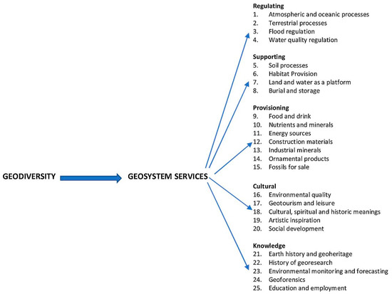
Figure 1.
Classification of geosystem services (GSs) according to [11]. The importance of the geodiversity in the definition of the GS is evident.
In the broader context of the term, some “geosites” are locations of scientific interest where tourist activities could be developed. This implies that these sites are important elements of geodiversity, which encompass the variety of geological features and processes that shape our natural world. Geosites provide valuable geosystem services by allowing for scientific research, education, and tourism, thereby enhancing our understanding and appreciation of Earth’s geological heritage. Mainly, those offering a tourist service can be interpreted as “geotourism and leisure activities” and classified as cultural services.
Geotourism is a new branch of tourism related to geodiversity, with its origin at the end of the 20th century [12], and it has been developed in the last two decades; today, the most accepted definition of geotourism is “a form of natural area tourism that specifically focuses on geology and landscape. It promotes tourism to geosites and the conservation of geodiversity and an understanding of Earth sciences through appreciation and learning” [13].
As suggested by Reynard et al. (2003) [14], it is important to analyse the relationship between geomorphology and geotourism in different ways. According to the authors [14], in fact, geomorphology can be considered as the primary (or original) offer, being a crucial element of landscapes that can provide opportunities for touristic development, changing with the morphology, politics, or economy of the area, but also with the evolving tourism demand. It can also be considered as the secondary (or derived) offer, in which a variety of tools or services are proposed for enhancing the original offer. However, it is of fundamental importance to take into consideration the changes that geomorphological processes may create (hazards or risks) and, at the same time, the impact of having tourists in the area, if not properly managed. Similarly, the relationship between geodiversity and geotourism should be considered in the context of sustainability, leading to sustainable development, especially in vulnerable and rural areas. Sustainable development has been defined as “development that meets the needs of the present generation without compromising the ability of future generations to meet their own needs” [15].
Although, concerning the specific interest of this paper, there is not a shared definition of a rural area. According to the methodology of classification adopted by the Organization for Economic Co-operation and Development (OECD) [16], a rural area is one of the three regional typologies of regions of OECD member countries. The criteria used by this methodology are (i) the population density and (ii) the size of the urban centres situated within a specific geographic area. Hence, a rural area has a population density lower than 150 inhabitants per square kilometre, and a region that contains an urban centre of less than 200,000 inhabitants [16], even though rural areas are not always very distant from the main urban centres [17]. Moreover, the economy of a rural area is fragile, due to the outflows of working age population [18], and it is based mainly on agriculture, with complementary activities connected to natural resources (forestry, fishing, crafting, etc.) [19].
Like other types of tourism, geotourism can be divided into seven categories, including rural geotourism [20]. The presence of geotourists in rural areas help the local economy because the visitors spend money on local activities and businesses, resulting in economical growth of the rural area and, simultaneously, the preservation of authenticity in the area [20].
Geotourism also encourages employment opportunities and economic benefits for the local population [21,22,23], and activities linked to geotourism, geoheritage, and geoconservation can have a central role in the sustainable development of a large diversity of regions [24,25,26,27,28,29,30,31,32,33,34,35], as well as within the UNESCO Global Geoparks (UGGps) [35,36,37,38,39,40,41,42,43,44,45,46,47,48]. Thanks to the complexity of its national territory, Italy holds a rich cultural and geological heritage [49] which is considered a “gym” for the geotourism activities, even outside the areas of UGGps. Italian geosites, in fact, can be found across the country in a diverse range of geological environments [50,51,52,53,54,55,56,57,58,59,60,61]. The full list of official Italian geosites is available on the Institute for Environmental Protection and Research (in Italian: Istituto Superiore per la Protezione e la Ricerca Ambientale, ISPRA) website [62].
Since geotourism focuses mainly on natural or semi-natural features and processes (geoheritage), it suffers the impacts (both direct and indirect, sensu [63]) of climate change. Consequences for geotourism include the degradation or disappearance of geotourism resources and their cultural significance, diminished or restricted access to geological features or their prominence, the loss of important witnesses of past events on the Earth, such as rock formations, sediment layers, and landforms, or the loss of climate records due to melting glaciers [64]. Despite the rich literature about the impacts of climate change on general tourism [65], there is a lack of scientific literature on the effects of climate change on geotourism, with the exception of two main topics: (i) glaciers and high mountain environments [50,66,67,68,69,70,71,72,73,74,75,76,77] and (ii) costal geosites, which suffer the risks of rising sea levels and coastal erosion [63,78,79,80,81,82,83,84,85].
The aim of the present study is to identify the best geosites for an initial development of geotourism in the Chiusella Valley, exploring the possibility of attracting geotourists in an area abundant in geodiversity elements which suffer from climate change, thereby increasing the awareness of geotourists on these issues.
To raise awareness among geotourists about past and present climate change, the final product of the present study is the realization of a geotouristic map with geosites in the Chiusella Valley and simplified informative cards with highlights on climate change in a medium mountain environment.
2. Study Area
The Chiusella Valley extends over the high and medium sector of the Chiusella river basin, in which eight municipalities are included (Brosso, Issiglio, Rueglio, Traversella, Val di Chy—formed by the union of the Alice Superiore, Lugnacco, and Pecco villages, Valchiusa—formed by the union of Drusacco, Meugliano, Trausella, and Vico Canavese villages, Vidracco, and Vistrorio), spreading over an area of 143 km2, with a length of 25 km (Figure 2). Many summits are over 2500 m a.s.l., with the Monfandì peak being the highest mountain of the Valley, with a maximum elevation at 2820 m a.s.l. The main river is the Chiusella, which originates from Monte Marzo (2756 m a.s.l.).
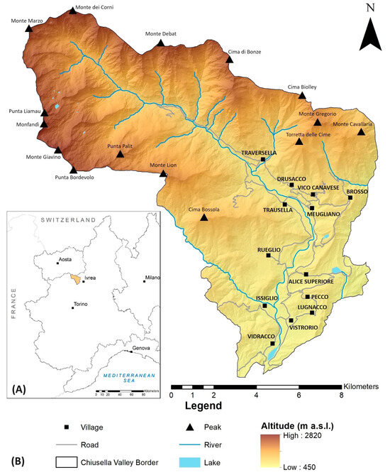
Figure 2.
Geographical location of Chiusella Valley. (A) Geographical position in Piemonte Region (NW Italy); (B) main geographical elements of the Chiusella Valley.
From an economical point of view, the Chiusella Valley did not suffer the processes of mass tourism, so it has maintained a high natural and cultural value and has a high potential for tourism due to its position. It is partially located in the Ivrea Morainic Amphitheatre (IMA), very close to the Gran Paradiso National Park and the most touristic Aosta Valley, not so far from the main cities of NW Italy (Torino is 80 km south, Milano is 150 km east). However, winter sport activities in the area are very limited because there has been no active ski area since the early 2000s, because increasing temperatures reduced the availability of natural snow during the winter season and, for such a small ski area, operating and maintaining the ski lifts was not economically viable.
Concerning social and demographic issues, like many other alpine areas, the depopulation phenomenon is present in the Chiusella Valley; from over 14.000 inhabitants in 1881, today there are only 5.197 people settled in the area and most of them are working outside the border of the valley [86].
2.1. Geological Setting
Traveling through the Chiusella Valley, geotourists can discover and cross different geological units, which demonstrates how geodiversity can be high even in a very small geographical area. Here, geotourists have the opportunity to encounter rocks belonging to the Earth’s crust and mantle and walk along a major tectonic discontinuity (geologically called the Insubric line, locally called Canavese line), which represents the suture between the European plate and the African plate. As a matter of fact, the Chiusella Valley itself represents a geological itinerary which crosses part of the western Alpine chain, from the internal sector to the central (axial) one; geotourists thus have the opportunity to touch rocks of sedimentary, magmatic, and metamorphic origin, in a geomorphological environment shaped by ancient glaciers and rivers.
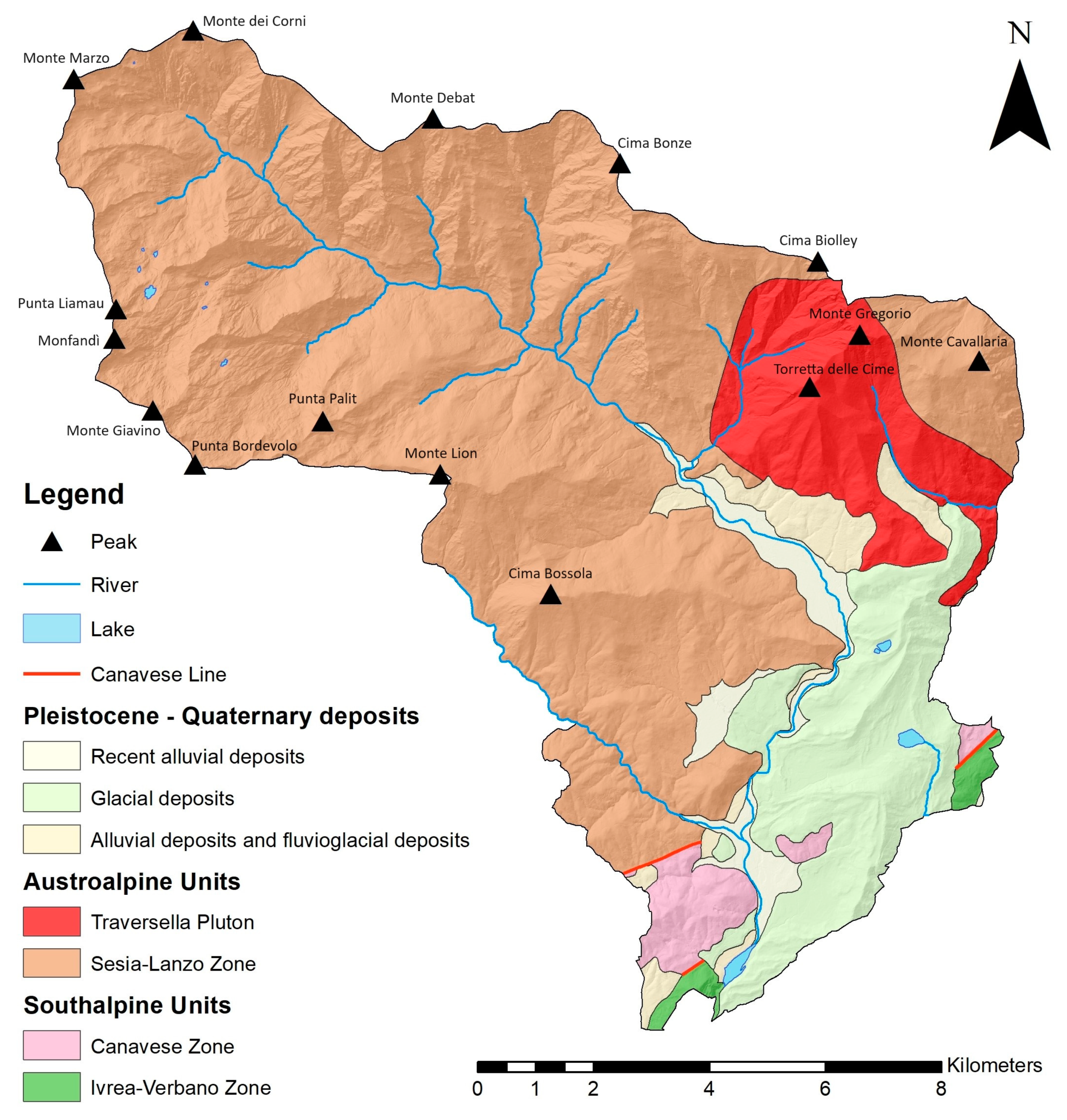
For a better understanding the great geodiversity of this Valley, a brief introduction to the geological setting of the area is necessary. In the Chiusella Valley, there are several rocks belonging to different geological unit of the outcrops of the Western Alps (Figure 3), with different origins and ages. According to [87], the Western Alps are divided into four geological domains (Southalpine, Austroalpine, Penninic, and Helvetic–Dauphinois domains) characterized by different paleogeographic origins and evolutionary history. In this perspective, the study area is characterized by several units belonging to the Southalpine and Austroalpine domains.
Within the Chiusella Valley, the Southalpine domain is represented by the geological units called the Ivrea–Verbano zone and Canavese zone.
The Ivrea–Verbano zone represents a segment of the Adriatic lower crust. It comprises a Variscan basement, transitioning from upper amphibolite to granulite facies (the Kinzigite Formation Auct. [88]). This crystalline basement was intruded by gabbro and diorite bodies of lower Permian age (the Mafic Complex Auct. [89,90]). Bodies of spinel peridotite, interpreted as subcontinental mantle slices, crop out along the western boundary of the Ivrea–Verbano zone, located between the Insubric line and the mafic complex [89].
As a result, the Ivrea–Verbano zone is considered one of the most spectacular cross-sections of lower-to-middle continental crust exposed on the Earth’s surface [91,92,93,94,95,96,97,98]. It also shows the lithological transition from the lower continental crust to the mantle, with gabbros, basic granulites, and peridotites [99]. In the Chiusella Valley, the geotourists can observe spectacular evidence of the geological features described above in the Monti Pelati area.
The Canavese zone is a juxtaposed tectonic unit between the Southalpine and Austroalpine domains, from which it is separated by segments of the Insubric line. A diversity of rocks (Paleozoic metamorphic basement intruded by magmatic rocks, on which the Meso–Cenozoic sedimentary successions rest) crops out in the Canavese zone. Within the Chiusella Valley, they consist of Permian granitoids and volcanic and sedimentary units of Mesozoic age [100]. These rocks can be observed near the Vistrorio, Vidracco, and Val di Chy villages.
The Austroalpine domain in the study area consists of the Sesia–Lanzo zone. This unit, cropping out in the upper part of the Chiusella Valley, is represented by both the Eclogitic Micaschist and Gneiss Minuti complexes [101,102]; these are rocks (micaschist and gneiss, with minor metabasite bodies and marbles lenses) of continental crust subducted and re-equilibrated under eclogitic conditions during the Alpine orogenesis. Moreover, the Sesia–Lanzo zone was affected by an intrusive magmatic activity of the Oligocene Age, corresponding to the most famous Brosso–Traversella pluton [103,104]. In particular, the Pluton is relatively small in dimension and is made of quartz diorite and monzodiorite rocks [105], which were also used as ornamental stones in the past [106]. Due to the intrusion of this pluton into the Sesia–Lanzo zone, important ore deposits have been formed, which are well preserved in the study area. In the geological literature, the Traversella ore deposits are classified as “skarn deposits” (named after the old Swedish mining town of Skarn [107]), still representing a fundamental source of metals (W, Fe, Au, Cu, Zn, Mo, and Sn) and, locally, industrial minerals [108]. This geological feature allowed the opening of the local iron mines and gave life to the Brosso–Traversella mining complex.
Concerning most recent geological phenomena, geotourists can appreciate the superficial deposits of Quaternary age; (i) glacial deposits from the small Chiusella Valley glacier and the large Balteo glacier (which gives life to the IMA, a testimony of the most evident and important glacial extension of the Aosta Valley in the Quaternary) [109,110]; (ii) in the lower part of the Chiusella Valley, alluvial deposits and fluvioglacial deposits, mainly in the Vico Canavese area, and (iii) alluvial deposits in the bottom area of the valley [111,112].

Figure 3.
Simplified geological map of the Chiusella Valley (adapted from [113,114,115]).
Figure 3.
Simplified geological map of the Chiusella Valley (adapted from [113,114,115]).
2.2. Geomorphological Setting
Concerning the present-day geomorphological landscape (Figure 4), the Chiusella Valley shows two distinct sectors; the upper sector has the traits of the alpine environment, with steep slopes, sparse vegetation, landslides, and tracks of glacial cirques, and the lower sector has a gentle morphology, with smooth hills, fields, and woods [116].
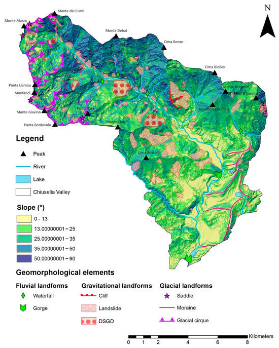
Figure 4.
Geomorphological sketch map of the Chiusella Valley.
According to [111], the Chiusella Valley had its own glacier during the Pleistocene ice ages. The glacier shaped the morphology of the area, but the area now presents only few relict morainic deposits, due to intense erosional processes along the slopes. In the upper part of the valley, traces of moraines can be found which are associated to erosional features such as glacial cirques. Other morainic deposits can be found on both sides of the Chiusella Valley, especially in the area between the Traversella and Brosso villages on the left side, and they form a small morainic amphitheatre where the Chiusella Valley meets the lateral Bersella Valley (Traversella area).
The eastern limit of the Chiusella Valley is represented by deposits belonging to the right moraine of the IMA. These deposits constitute various morainic ridges, with irregular development in the area of the Brosso and Val di Chy villages [111].
The past occurrence of glacial modelling in the Chiusella Valley is witnessed not only by the morainic deposits in the upper part of the Valley, but also by the presence of glacial terraces, erratic boulders, glacial striations, and the rochees mountonneé widespread in the territory [111,117]. Traces of cirque glaciers can be seen in the right bank of the Chiusella Valley, from the head to the SE side of Punta Palit, as highlighted in the geomorphological map. Moreover, glacial saddles are also found on the border of the valley, communicating with the nearby valleys (Figure 4).
One of the major geomorphological phenomena of the Chiusella Valley is the evident stream diversion in the area south of Valchiusa. During and at the end of the ice ages, the IMA blocked the flow of the Chiusella river, forcing it to diverge its path from W–E to N–S [111].
The area has also two morainic lakes (Alice Lake and Meugliano Lake), delimitated by moraines of different ages [109,118]. Moorlands form a plain in the surrounding area of the Alice Lake.
All of the lower part of the Chiusella Valley shows smooth morphologies, due to the presence of fluviolacustrine terraces in the area.
According to [111], at the end of Pleistocene ice ages, the increasing glacial melt water created various streams from the small lateral valleys; the high and steep slopes accentuated the speed of the water, thus allowing the excavation of some gorges (“guja” in local dialect), the most important ones of which are the “Guja di Garavot” and the “Guja di Gussej”. Alluvial fans, both active and inactive, are frequent at the meeting point of the small lateral valley with the principal Chiusella Valley. Depositional and erosional processes caused by the Chiusella stream and its attributes are still very active, particularly in the middle valley, as this happened during the October 2020 flood [119].
To complete the geomorphological overview, the area presents high instability of the slopes. In fact, according to the landslide information system in the Piemonte region (in Italian: Sistema Informativo Frane in Piemonte—SIFraP) of the Regional Agency for the Protection of the Environment (in Italian: Agenzia Regionale per la Protezione Ambientale—ARPA), it counts more than 300 landslides and other gravitational features [120], including an active monitored deep-seated gravitational slope deformation (DSGSD) located in Delpizzen locality, in the Traversella municipality [121].
2.3. Cultural Mining Heritage in the Chiusella Valley
Inhabited since prehistoric times, the importance of the Chiusella Valley is mainly linked to the mines and rock quarries of the area and their activities. The Traversella–Brosso mining complex was once the biggest iron extraction point of the Western Alps., The Traversella quarry was especially rich in iron and just the mineral extracted here was enough to meet almost the whole demand for iron in the subalpine area. The richness in iron minerals, such as magnetite and pyrite, is because of the Traversella pluton.
The opening years of the Traversella and Brosso mines are still uncertain but are probably from Roman times or even before. The first official evidence of activities in the quarries are 1570 and 1487, respectively [122]. In the centuries after, the presence of such active and productive quarries led to the invention of new techniques, such as the blast furnace, which was very useful in times of local and regional wars. This huge mining activity increased the number of people living in the area, especially from the 18th century. After the French occupancy of the region, the mining activity reduced its production for a few years up until the closure. After that, years of production were alternated to years of crisis, but without reaching the level of the first years. In the work “Le miniere dei Baduj” [122], the history of the Traversella mining is well explained, with details on activities conducted within the mine and complete data about the quality and quantity of the extracted minerals. With the definitive closure of the Traversella and Brosso quarries (1971 and 1964, respectively), a big part of the population left the area, resulting in the depopulation of the Chiusella Valley, which is still going on nowadays [122,123,124].
The Chiusella Valley, moreover, is known worldwide by mineralogists because of over one hundred species of minerals found in the Traversella and Brosso mining sites. These minerals are shown in museums worldwide [125,126]. In this context, the mining districts of Traversella and Brosso represent symbols of material and cultural value of the geodiversity of the Piemonte region [127]. The mining paths, the scattered forges in the territory, the extraction tunnels, and the colourful veins rich in sulphur and the precious mineralisations represent cultural geosites that speak of the past, but also of the future. Certainly, they remind us of the hard but fruitful work that miners have carried out in order to benefit from the rich mining geodiversity, but they also teach our generation, and future ones, the necessity of reducing anthropic impacts on the environment [128].
3. Materials and Methods
The choice of the geosites for the development of geotourism in the Chiusella Valley started from the analysis of the scientific literature. The selection includes all the sites that are recorded in the literature as having a connection to Earth science interests and educational activities conducted in the area, with a focus on the geodiversity and geoheritage of the territory.
The geosite assessment model (GAM) from [129] has been applied to the sites of geological interest for the individuation of the best geosites for the geotourism development in the Chiusella Valley. For each geosite chosen using the GAM, a descriptive card (or inventory card, modified by the ISPRA [130] according to the geosite inventory initiatives in the Piemonte region [131,132,133,134,135,136]) and the geosystem services table [11] have been filled. After the filling of the inventory card and the GS table, traces of past and present climate change have been highlighted in some geosites. For the individuation of the ongoing climate change, climatic indexes have been calculated using data from Arpa Piemonte [137].
The final products of this work are (i) a simplified informative card for each geosite, based on the descriptive card and the geosystem services table, and (ii) a geotouristic map, in which the most significant geological and geomorphological features are maintained, with the most important touristic information. In this sense, it is important to use scientific but simplified sentences and cartography that is understandable for people with a non-scientific background; i.e, the geotourists.
The workflow of the methodology adopted for this study is shown in Figure 5.

Figure 5.
Workflow of the study.
3.1. Geosites Assessment Model
The structure of the GAM is explained by [129]. The evaluation of the sites is given by the presence of 27 indicators, divided into two groups of values, main values and additional values [129].
The main values include three categories of indicators; scientific/educational value (VSE), scenic/aesthetic value (VSA), and protection value (VPr). The main values are 12 sub-indicators in total. The additional values are composed of two categories of indicators, functional value (VFn) and tourism value (VTr). The additional values are composed of a total of 15 sub-indicators. Every sub-indicator is graded from 0 to 1, and the GAM is defined by an algebraic Equation (1):
GAM = main values (VSE + VSA + VPr) + additional values (VFn + VTr).
After the assessment of each site, a matrix of the two groups of values must be completed for the individuation of the best geosites for the promotion of geotourism in the area. On the X axis, the main values are presented, while the additional values are located on the Y axis. The matrix is divided into nine zones (fields) indicated as Z(i,j) (i,j = 1,2,3), in which the geosites are plotted according to the previous evaluation of the sub-indicators. Figure 6 shows the matrix.
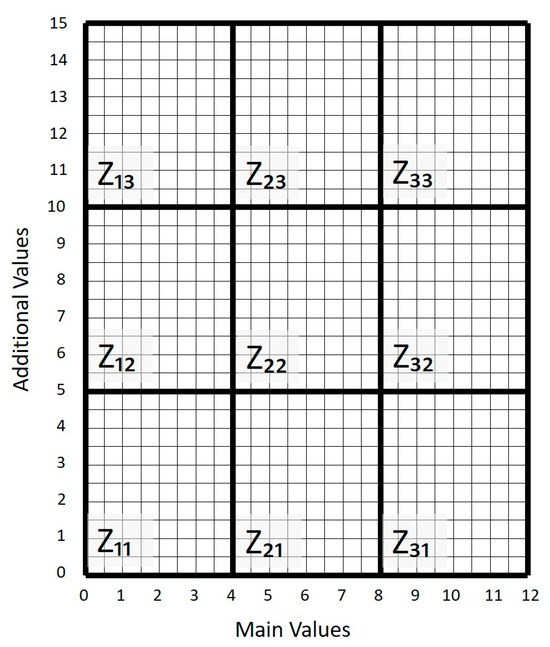
Figure 6.
GAM matrix used for the assessment of the geosites. On the X axis main values are inserted; on the Y axis, additional values are inserted. Each axis is divided into three sections, for a total of nine zones (or fields).
3.2. Descriptive Card and GS Table
The descriptive card used for this work has been adapted from the one proposed by the ISPRA [130] (developed within the project named “Conservation of the Italian Geological heritage” [138,139,140]). The descriptive card has been developed by the Earth Sciences Department of the University of Torino, Italy, through the years. The first attempt at developing a suitable inventory card to be applied to the geodiversity of the Piemonte region was developed by [131], in the area of the Gran Paradiso National Park, then applied to other alpine sectors [132]. Subsequently, the work of [133] highlighted the necessity to generate an inventory card compatible with the one proposed by the ISPRA. In this sense, [134], in accordance with [131], the following sections were added: (i) geological hazards, (ii) natural vulnerability, and (iii) anthropic impacts. These additions are useful for the touristic fruition and the management aspects of the geosites, due to the increasing number of geotourists. After the approval of the Piemonte Regional Law n. 23/23 (named “Provisions for the conservation, management and valorisation of the geological heritage” [141]), the card has been improved by the working group of the Earth Sciences Department of the University of Torino, resulting in the descriptive card used in the present work. This card contains a qualitative description of each site. It has six sections; (i) general information (name, geographical information, brief description, environmental context, etc.); (ii) features of geodiversity of interest for the geosite (lithostratigraphy, structure, geomorphology, soils, hydrogeology); (iii) scientific and other interests; (iv) environmental and territorial dynamics (hazard, vulnerability, human activities and impacts); (v) use of the geosite (accessibility, visibility, services, risks, and season for visiting), and (vi) protection and conservation (with space for suggesting valorisation actions). The filling of the cards was performed after a field survey for each site, with occasional help from the scientific literature.
The GS table for each geosite has been filled, indicating one or more geosystem services according to the information provided in the descriptive card.
The descriptive card used is available in the Supplementary Materials (Table S1).
3.3. “Witnesses” of Climate Change
The daily climatological data were downloaded from three meteorological stations of the Arpa Piemonte network [137]. The selected stations were Traversella (1165 m a.s.l.), Cavallaria (1270 m a.s.l.), and Meugliano (650 m a.s.l.). The meteorological parameters analyzed on a daily scale in this study were maximum temperature (TX), minimum temperature (TN), and liquid precipitation. The time intervals of the climate data considered were the following: (i) Traversella, 1996–2022; (ii) Cavallaria, 1998–2022, and (iii) Meugliano, 1988–2022.
For the climatic analysis, we selected specific indices (Table 1) from 70 of those produced by the Expert Team (ET) on Climate Change, as recommended by the World Meteorological Organization—Commission for Climatology (WMO—CCl) [142], and calculated at annual scale. In addition, for each index annual trends were calculated with the Mann–Kendall test [143] with a significance level of 5% for temperature indices and 10% for precipitation indices.

Table 1.
Selected temperature and precipitation indices.
The information in the descriptive cards and in the GS table have been used, together with climatic indexes, to identify those sites where the effects of past and present climate changes are well documented. In doing so, research into historical iconography has been conducted.
3.4. Geotouristic Map and Simplified Card of Geosites
For each geosite, a simplified descriptive card has been provided. It has been elaborated on from the information contained in the descriptive card and the GS table. The information provided to the geotourists includes (i) name of the geosite, (ii) geographic information, (iii) geological and cultural heritage contents, (iv) accessibility, (v) a brief description of the geosite, (vi) geodiversity elements, (vii) geosystem services provided, and (viii) iconography of the geosite. The structure of the simplified descriptive card is available in Figure 7. Finally, the geosites identified with the GAM have been inserted on a geographic map of the area, in which accessibility elements (roads and paths) and tourist amenities (accommodations, restaurants, museums, etc.) are also included. Major geodiversity elements and cultural heritage elements are also added on the map. The geotouristic map shows also the main touristic facilities in order to help the geotourists in the planning of their experience.
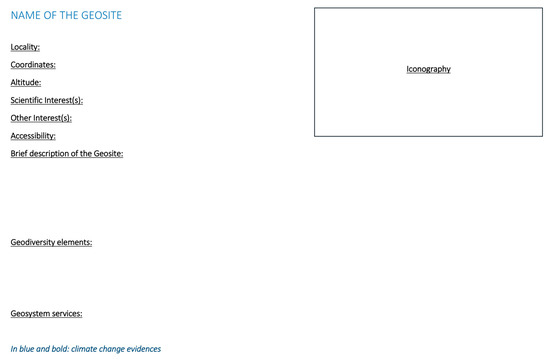
Figure 7.
Structure of the simplified informative card.
4. Results
The analysis of the scientific literature and educational activities has led to the identification of nine potential geosites. The list of the geosites is shown in Table 2.
Table 2.
List of potential geosites.
In the application of the GAM to the eight sites of interest, some local activities that usually give information to the tourists have been considered as “visitor centres”, due to the lack of proper visitor centres in the Chiusella Valley.
In the Figure 8, the matrix shows the results of the GAM. The assessment of each sub-indicator for each geosite is available in the Supplementary Materials (Table S2).
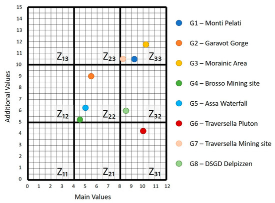
Figure 8.
Disposition of geosites in the GAM matrix according the results of the assessment. The assessment of each geosite has been inserted into the GAM matrix. The majority of the geosites show medium to high main value and additional value, with the exception of G6, which it shows high main value, but low additional value.
Four sites resulted as the best selections for geotourism promotion of the area; G1, G3, G7, and G8. They are classified in Z33, with very high main and additional values, and Z32, with high main value and medium additional value. Moreover, high importance has been given to the additional value “accessibility”, in order to be more inclusive in the development of geotourism in the area. For each geosite individuated, the descriptive card has been filled after a field survey, and the GSs have been identified (Table 3).
Table 3.
GS provided by each geosite.
Concerning the climatic indexes, the most important results were provided from the climatic indices of the Meugliano and Traversella station data; on the contrary, the data from the Cavallaria station presented too many gaps to provide significant results. In Table 4, the annual trend of the selected indices is reported.
Table 4.
Trend of selected indices, in bold are the statistically significant results.
From the trends, we can say that there has been an increase in temperature since 1988 within the area of study. The most interesting results are on the minimum temperatures (TN10p, TN90p, TNm); in fact, we observed an increase in the mean minimum temperature and an increase in the days with a minimum temperature over the 90th percentile, and a decrease in the days with a minimum temperature under the 10th percentile, in both locations (Meugliano and Traversella). These six trends are also statistically significant, which underlines the robustness of the results. On the contrary, the precipitation indices results are different from each other. The annual total precipitation trend and the R95ptot trend are positive for Meugliano and negative for Traversella, but are always not statistically significant.
Analyses of the climatic indexes and iconographic research over the study area allowed further selection of geosites in order to designate the best locations for creating public engagement on climatic issues. Two areas have been identified:
- G3 and G8 are suitable for showing evidence of present-day global warming;
- G3 is also a good site in which traces of the past climate changes can be identified.
The G3 morainic ridges and glacial deposits correlate to the Pleistocene ice ages, thus allowing the comprehension of the past climate in the area. However, within G3 it is also possible to identify traces of ongoing climate change. In fact, historical pictures from this geosite (Figure 9) show two intermorainic lakes completely iced oveer, with people walking on the surface of the Meugliano Lake; 2010 was the last time this happened, whereas in the last century it was a frequent annual condition. This is in line with the trend of the increasing temperature, in which the days with a temperature below 0 °C are decreasing. Moreover, the GeoDidaLab geoscience education laboratory, led by the Earth Sciences Department of the University of Torino [144], has its headquarters within the G3 area. This laboratory has been identified as the perfect hub for indoor activities concerning the past and present climate change in the area.

Figure 9.
Iced lakes. (A) Meugliano Lake, with people walking on the iced surface (photo: Bovio Luigi, 31st December 2010). (B) Alice Lake (photo: Gastaldi Enzo, February 2010).
The geosite G8 is a DSGSD on which ski facilities were built. Nowadays, the ski lifts are no longer in function due to the reduction in the amount of snow during winter, again due to the increasing temperature. However, the presence of the ski runs and the abandoned ski lifts serves as significant evidence of ongoing climate change. Moreover, walking uphill on the DSGSD, it is possible to appreciate the geodiversity of the landscape of the Chiusella Valley.
After the collection of the totality of the information, a simplified informative card has been filled for each geosite (see Supplementary Materials Table S3). The use of a simplified, but still specific, vocabulary is vital in order to help non-experts understand the most important concepts of the geological importance of the geosites and the impact of climate change. The final step has been the generation of the Chiusella Valley geotouristic map (Figure 10).
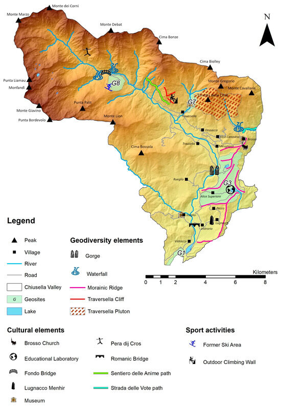
Figure 10.
Geotouristic map of Chiusella Valley. Geosites: G1—Monti Pelati; G3—morainic area; G7—Traversella mining complex; G8—DSGSD, Delpizzen.
5. Discussion
Geodiversity and geoheritage studies and geosite assessment for the geotouristic development of the Chiusella Valley show the presence of eight sites with medium or high scientific importance, but also other important values, such as ecological value, educational potential, connection with local culture and history, and landscape importance. However, only four of the eight geosites have been chosen for the development of geotourism in the area, as they resulted in high main and additional values (G1, G3, G7) or high main value and medium additional value (G8), according to the GAM method. G1 is already part of the inventory of national geosites made by the ISPRA.
For the four geosites identified, the descriptive card and the GS table have been filled. When analysing the GSs provided by the geosites, only G8 showed a regulation GS. Among all 25 GSs, only two of the following were shared by all: (7) land and water as platform, and (17) geotourism and leisure. However, the impact of climate change can show a shift in the actual GS, as occurred in the case of G8; in fact, “social development” in the GS (20) was provided in the past, thanks to the opening of the ski lifts which were attracting tourism even from outside the Chiusella Valley. The reduction of the amount of snow led to the closure of the ski lifts, reducing the attractiveness of the territory during the winter season. In the same way, the increase in the temperature changed processes within the morainic lakes in G3, leading to a faster landfill of the lake due to the major eutrophication of the water, with a consequent loss of geodiversity and geoheritage and reduction in geotourist presence. After the individuation of the geosites, it is important to look at other infrastructure and services for implementing geotouristic offerings. The two main constraints are (i) accessibility, because the geosites should be reachable for everyone, without being too selective, at least in the initial phase of geotouristic development, and (ii) touristic facilities, because the presence of a high number of tourists must be supported and managed by the local activities.
The geosites identified in this study are accessible through existing paths. As such, the creation of new routes is not necessary, so the environmental impact is very low, even though some works are necessary for securing parts of some paths, or for keeping the trails clean and enjoyable without any risks related to the natural environment.
Analysing the touristic facilities in the territory, the presence of numerous accommodation and restoration places spread through the territory is evident, but what is prominent is the lack of an official visitor centre, which is fundamental for the promotion of the area. At the moment, information regarding activities and places in the Chiusella Valley is given from local activities where some touristic flyers can be found. The presence of the headquarters of the GeoDidaLab, a geoscience and educational laboratory, is fundamental in order to spread knowledge of geodiversity and geoheritage, but also climate changes within the area. The activities of the laboratory are appropriate for both schools and general geotourists.
Moreover, the increase in the temperature across the region, especially in the large cities and in the Po Plain, has forced the tourists to find places in the natural environment with a less warm climate. This characteristic can be found in the Chiusella Valley, hence the necessity of developing an adequate touristic and geotouristic offer in the area.
Thanks to the simplified cards for the geosites and the Geotouristic map, geotourists can learn more about the geodiversity of the area, and they can also include geological and cultural heritage for a more complete touristic offer and a longer stay in the Chiusella Valley.
6. Conclusions
The results of this study led to the identification of four geosites, allowing a first step in the geotourism development of the Chiusella Valley.
The presence of some facilities and essential activities in the territory has been indicated as an opportunity for sustainable mobility in the area, thus decreasing the need for daily commutes from the Chiusella Valley to the nearby urban areas of Ivrea and Torino and reducing the impact of travelling long distances by car. Moreover, the development of geotourism in the area presents the possibility of employing local people in local tourism activities, and allows the showcasing of local activities and products to the tourists, generating a new sustainable economy in the territory. The involvement of the local communities is also crucial in the promotion of the geosites, with initiatives related to the knowledge of the geoheritage of the area. At the same time, local residents are the first respondents in the territory and they can quickly identify issues, advocate for conservation efforts, and contribute solutions and strategies for the long-term preservation of the geosites.
The four geosites identified in the study are located in different parts of the Valley, from the entrance (Monti Pelati, in Vidracco municipality) to the end of the driveway (DSGSD of Delpizzen), crossing the medium valley (morainic area, on the eastern border, and the Traversella mining site). They provide almost all geosystem services. The geosites are reachable by car or with a short walk, and their importance is also due to the natural environment in which they are located. There is also a significant connection with the issue of climate change, both past and ongoing. To highlight it, two geosites have been chosen and one of them can offer the possibility of developing a “hub” in which climate change can be well explained and where geotourists can become more aware of the impacts of global warming.
There is no need for new paths to connect the geosites. Consequently, the environmental impact of geotourism will be very low, concerning only the installation of new panels for the geotouristic map and the simplified descriptive cards. However, more investment and improvements are required in the case of tourist values in order to attract a larger number of tourists in the future, especially the creation of visitor centres, guided tours and the promotion of geo-initiatives, creating richer geotouristic offerings and attracting more tourists.
Hence, the final products of this study are the simplified informative cards and a geotouristic map, understandable by the general public, with the intent of involving new people in geodiversity studies and conservation, thanks to new knowledge on the topic and the understanding of the impacts of climate change.
Since this is an initial phase of the development of geotourism in the Chiusella Valley, the application of the geosite assessment model by [129] was appropriate, because it only takes expert views into consideration. For further studies, after the success of this first proposal, the modified geosite assessment model (M-GAM) by [145] will be used for new geosites according to tourists’ opinions and interests.
Finally, we consider that future studies on the climate issues in the region should address the conditions of the morainic lakes, and collect further environmental data to gain and implement knowledge of post-glacial climate warming in an area of rich geoheritage.
Supplementary Materials
The following supporting information can be downloaded at: https://www.mdpi.com/article/10.3390/geosciences14070175/s1, Table S1: Model of descriptive card; Table S2: GAM results; Table S3: Simplified cards–G1, G3, G7, G8.
Author Contributions
Conceptualization: A.N., M.P. and M.G.; Data curation: A.N., E.S., A.M.C., F.A., M.P. and M.G.; Formal analysis: A.N., A.M.C. and F.A.; Investigation: A.N., E.S., R.B.K., A.M.C., F.A. and M.G.; Methodology: A.N., R.B.K., A.M.C., F.A., M.P. and M.G.; Project administration: A.N. and M.G.; Resources: A.N., E.S., R.B.K., A.M.C., F.A., M.P. and M.G.; Supervision: A.N., R.B.K. and M.G.; Validation A.N., E.S., R.B.K., A.M.C., F.A. and M.G.; Visualization: A.N., E.S., R.B.K., F.A. and M.G.; Writing—original draft: A.N., E.S., R.B.K., M.P. and M.G.; Writing—review and editing: A.N., E.S., R.B.K., A.M.C., F.A., M.P. and M.G. All authors have read and agreed to the published version of the manuscript.
Funding
The work was partly carried out in the framework of (i) the Arctic Hubs (Global drivers, local consequences) EU H2020 RIA Project Number: 869580 and (ii) the NODES Spoke 4 project within the National Recovery and Resilience Plan (PNRR) Ministerial Decree No. 1054 dated 23 June 2022.
Data Availability Statement
Data are contained within the article and Supplementary Materials.
Acknowledgments
We would like to thank the reviewers and the Editorial Board of Geosciences for the reviews, suggestions, and opportunity.
Conflicts of Interest
The authors declare that they have no known competing financial interests or personal relationships that could have appeared to influence the work reported in this paper. The authors declare no conflicts of interest.
References
- Sharples, C. A Methodology for the Identification of Significant Landforms and Geological Sites for Geoconservation Purposes; Report to The Forestry Commission; Forestry Tasmania: Hobart, Tasmania, Australia, 1993. [Google Scholar]
- Wiedenbein, F.W. Ein Geotopschutzkonzept für Deutschland. In Geotopschutz Probleme: Der Methodik und der Praktischen; University of Saarland: Saarbrucken, Germany, 1993. [Google Scholar]
- Boothroyd, A.; McHenry, M. Old Processes, New Movements: The Inclusion of Geodiversity in Biological and Ecological Discourse. Diversity 2019, 11, 216. [Google Scholar] [CrossRef]
- Gray, M. Geodiversity: Valuing and Conserving Abiotic Nature, 2nd ed.; 1. publ.; Wiley Blackwell: Chichester, UK, 2013; ISBN 978-0-470-74214-3. [Google Scholar]
- Sharples, C. Concepts and Principles of Geoconservation; Tasmanian Parks & Wildlife Service Website: Hobart, Tasmania, 2002; p. 79. [Google Scholar]
- Reynard, E. Geosites. In Encyclopedia of Geomorphology; Goudie, A.S., Ed.; Routledge: London, UK, 2004; p. 440. [Google Scholar]
- Brilha, J. Inventory and Quantitative Assessment of Geosites and Geodiversity Sites: A Review. Geoheritage 2016, 8, 119–134. [Google Scholar] [CrossRef]
- Panizza, M. Geomorphosites: Concepts, Methods and Examples of Geomorphological Survey. Chin. Sci. Bull. 2001, 46, 4–5. [Google Scholar] [CrossRef]
- Millennium Ecosystem Assessment (MEA). Ecosystems and Human Well-Being: Synthesis; Island Press: Washington, DC, USA, 2005; ISBN 978-1-59726-040-4. [Google Scholar]
- Gray, M. Other Nature: Geodiversity and Geosystem Services. Environ. Conserv. 2011, 38, 271–274. [Google Scholar] [CrossRef]
- Chakraborty, A.; Gray, M. A Call for Mainstreaming Geodiversity in Nature Conservation Research and Praxis. J. Nat. Conserv. 2020, 56, 125862. [Google Scholar] [CrossRef]
- Hose, T.A. Selling the Story of Britain’s Stone. Environ. Interpret. 1995, 10, 16–17. [Google Scholar]
- Newsome, D.; Dowling, R.K. Geotourism: The Tourism of Geology and Landscape, 1st ed.; Goodfellow Publishers: Oxford, UK, 2010; ISBN 978-1-906884-09-3. [Google Scholar]
- Reynard, E.; Holzmann, C.; Guex, D. Géomorphologie et tourisme: Quelles relations? In Proceedings of the Géomorphologie et Tourisme. Actes de la Réunion Annuelle de la Société Suisse de Géomorphologie (SSGm), Finhaut, Switzerland, 21–23 September 2001; Reynard, E., Holzmann, C., Guex, D., Summermatter, N., Eds.; Institut de Géographie: Lausanne, Switzerland, 2003; pp. 1–10. [Google Scholar]
- World Commission on Environment and Development (WCSD). Our Common Future. Brundtland Report; Oxford University Press: Oxford, UK; New York, NY, USA, 1987. [Google Scholar]
- Organization for Economic Co-Operation and Development (OECD). OECD Regional Typology. Directorate for Public Governance and Territorial Development. 2011. Available online: https://www.oecd.org/cfe/regional-policy/OECD_regional_typology_Nov2012.pdf (accessed on 12 March 2024).
- Elbersen, B.; van Eupen, E.; Mantel, S.; Verzandvoort, S.; Boogaard, H.; Mucher, S.; Cicarreli, T.; Elbersen, W.; Bai, Z.; Iqbal, Y.; et al. D2.1. Definition and Classification of Marginal Lands Suitable for Industrial Crops in Europe. 2017. Available online: https://zenodo.org/records/3539229 (accessed on 20 June 2024). [CrossRef]
- Brezzi, M.; Dijkstra, L.; Ruiz, V. OECD Extended Regional Typology: The Economic Performance of Remote Rural Regions; OECD Regional Development Working Papers; OECD iLibrary: Online, 2011; Volume 6. [Google Scholar]
- Surchev, P. Rural areas—Problems and opportunities for development. Trakia J. Sci. 2010, 8, 234–239. [Google Scholar]
- Farsani, N.T.; Coelho, C.O.A.; Costa, C.M.M. Rural Geotourism: A New Tourism Product. Acta Geoturistica 2013, 4, 1–10. [Google Scholar]
- Dowling, R.K. Geotourism’s contribution to local and regional development. In Geotourism and Local Development; de Carvalho, C., Rodrigues, J., Eds.; Camar municipal de Idanha-a-Nova: Idanha-A-Nova, Portugal, 2009; pp. 15–37. [Google Scholar]
- Dowling, R.K. Global Geotourism—An Emerging Form of Sustainable Tourism. Czech J. Tour. 2013, 2, 59–79. [Google Scholar] [CrossRef]
- Newsome, D.; Dowling, R. Geoheritage and Geotourism. In Geoheritage; Elsevier: Amsterdam, The Netherlands, 2018; pp. 305–321. ISBN 978-0-12-809531-7. [Google Scholar]
- Frey, M.-L.; Schäfer, K.; Büchel, G.; Patzak, M. Geoparks—A Regional, European and Global Policy. In Geotourism; Elsevier: Amsterdam, The Netherlands, 2006; pp. 95–117. ISBN 978-0-7506-6215-4. [Google Scholar]
- Pająk, J.; Golonka, J.; Krobicki, M. Attractions of unanimated nature of the northern Vietnam as a basis for tourist development (Atrakcje przyrody nieożywionej północnego Wietnamu jako podstawa dla rozwoju turystyki). Geoturystyka 2006, 4, 5–26. [Google Scholar]
- Pralong, J.P. Geotourism: A New Form of Tourism Utilising Natural Landscapes and Based on Imagination and Emotion. Tour. Rev. 2006, 61, 20–25. [Google Scholar] [CrossRef]
- Pralong, J.-P. Research approaches concerning the guiding image of ‘Protection through use’ in Geoparks and geotouristic destinations. In Geopark and Geotourism Research: Results of the International Workshop at Karlsruhe 2006; Vogt, J., Megerle, A., Eds.; University of Karlsruhe: Karlsruhe, Germany, 2006; pp. 51–55. [Google Scholar]
- Gibson, R.L.; Blom, M. Geotourism Potential of the Vredefort Dome, South Africa: Challenges, Opportunities, Progress and Recommendations. In Proceedings of the Large Meteorite Impacts and Planetary Evolution IV Conference, Vredefort Dome, South Africa, 17–21 August 2008. [Google Scholar]
- Ghani, K.A.; Leman, M.S.; Komoo, I. Sustainable tourism and geoparks. In Proceedings of the Paper Presented at the Third Asia Pacific Geoparks Network Symposium, For the Innovation of the APGN, Jeju Island, Republic of Korea, 7–13 September 2013. [Google Scholar]
- Lazzari, M. Geosites, cultural tourism and sustainability in the Gargano National Park (Southern Italy): The case study of the La Salata (Vieste) geoarchaeological site. Rend. Online Soc. Geol. It. 2013, 28, 97–101. [Google Scholar]
- Božić, S.; Tomić, N. Canyons and Gorges as Potential Geotourism Destinations in Serbia: Comparative Analysis from Two Perspectives—Generalgeotourists’ and Pure Geotourists’. Open Geosci. 2015, 7, 531–546. [Google Scholar] [CrossRef]
- Kubalíková, L.; Kirchner, K. Geosite and Geomorphosite Assessment as a Tool for Geoconservation and Geotourism Purposes: A Case Study from Vizovická Vrchovina Highland (Eastern Part of the Czech Republic). Geoheritage 2016, 8, 5–14. [Google Scholar] [CrossRef]
- Beraaouz, M.; Macadam, J.; Bouchaou, L.; Ikenne, M.; Ernst, R.; Tagma, T.; Masrour, M. An Inventory of Geoheritage Sites in the Draa Valley (Morocco): A Contribution to Promotion of Geotourism and Sustainable Development. Geoheritage 2019, 11, 241–255. [Google Scholar] [CrossRef]
- Shekhar, S.; Kumar, P.; Chauhan, G.; Thakkar, M.G. Conservation and Sustainable Development of Geoheritage, Geopark, and Geotourism: A Case Study of Cenozoic Successions of Western Kutch, India. Geoheritage 2019, 11, 1475–1488. [Google Scholar] [CrossRef]
- García-Sánchez, L.; Canet, C.; Cruz-Pérez, M.Á.; Morelos-Rodríguez, L.; Salgado-Martínez, E.; Corona-Chávez, P. A Comparison between Local Sustainable Development Strategies Based on the Geoheritage of Two Post-Mining Areas of Central Mexico. Int. J. Geoheritage Parks 2021, 9, 391–404. [Google Scholar] [CrossRef]
- Stoffler, D.; Posges, G.; Barfield, R. Development of Geotourism in the National Geopark Ries, Southern Germany. In Proceedings of the Large Meteorite Impacts and Planetary Evolution IV Conference, Vredefort Dome, South Africa, 17–21 August 2008. [Google Scholar]
- Burlando, M.; Firpo, M.; Queirolo, C.; Vacchi, M. A new strategy to promote sustainable tourism in Beigua Geopark (Italy). In New Challenges with Geotourism. Proceedings of the VIII European Geoparks Conference, Idanha-a-Nova, Portugal, 14–16 September 2009; de Carvalho, C.N., Rodrigues, J., Eds.; Printmor Impressores Lda: Rio Maior, Portugal, 2009. [Google Scholar]
- Burlando, M.; Firpo, M.; Queirolo, C.; Rovere, A.; Vacchi, M. From Geoheritage to Sustainable Development: Strategies and Perspectives in the Beigua Geopark (Italy). Geoheritage 2011, 3, 63–72. [Google Scholar] [CrossRef]
- Zouros, Ν.C. Geotourism in Greece: A Case Study of the Lesvos Petrified Forest Geopark. In Global Geotourism Perspectives; Dowling, R.K., Newsome, D., Eds.; Goodfellow Publishers: Oxford, UK, 2010; ISBN 978-1-906884-17-8. [Google Scholar]
- Lee, C.T. Geodiversity and geotourism development in Caoling Geopark, Yunlin County, Taiwan. In Proceedings of the Third Asia Pacific Geoparks Network Symposium, for the Innovation of the APGN, Jeju Island, Republic of Korea, 7–13 September 2013. [Google Scholar]
- Dong, H.; Song, Y.; Chen, T.; Zhao, J.; Yu, L. Geoconservation and Geotourism in Luochuan Loess National Geopark, China. Quat. Int. 2014, 334–335, 40–51. [Google Scholar] [CrossRef]
- Miller, R.F.; Buhay, D.N. Turning a Forgotten Geological Heritage into a Geological Park: Developing Stonehammer Geopark. Geoheritage 2014, 6, 29–39. [Google Scholar] [CrossRef]
- Henriques, M.H.; Brilha, J. UNESCO Global Geoparks: A Strategy towards Global Understanding and Sustainability. Episodes 2017, 40, 349–355. [Google Scholar] [CrossRef]
- Han, J.; Wu, F.; Tian, M.; Li, W. From Geopark to Sustainable Development: Heritage Conservation and Geotourism Promotion in the Huangshan UNESCO Global Geopark (China). Geoheritage 2018, 10, 79–91. [Google Scholar] [CrossRef]
- Cai, Y.; Wu, F.; Han, J.; Chu, H. Geoheritage and Sustainable Development in Yimengshan Geopark. Geoheritage 2019, 11, 991–1003. [Google Scholar] [CrossRef]
- Perotti, L.; Bollati, I.M.; Viani, C.; Zanoletti, E.; Caironi, V.; Pelfini, M.; Giardino, M. Fieldtrips and virtual tours as geotourism resources: Examples from the Sesia Val Grande UNESCO Global Geopark (NW Italy). Resources 2020, 9, 63. [Google Scholar] [CrossRef]
- Lee, Y.; Jayakumar, R. Economic Impact of UNESCO Global Geoparks on Local Communities: Comparative Analysis of Three UNESCO Global Geoparks in Asia. Int. J. Geoheritage Parks 2021, 9, 189–198. [Google Scholar] [CrossRef]
- Duangkrayom, J.; Jintasakul, P.; Songtham, W.; Kruainok, P.; Naksri, W.; Thongdee, N.; Grote, P.J.; Phetprayoon, T.; Janjitpaiboon, K.; Meepoka, R. Geodiversity in Khorat Geopark, Thailand: Approaches to Geoconservation and Sustainable Development. Int. J. Geoheritage Parks 2022, 10, 569–596. [Google Scholar] [CrossRef]
- Piacentini, T.; Castaldini, D.; Coratza, P.; Farabollini, P.; Miccadei, E. Geotourism: Some Examples in Northern-Central Italy. Geoj. Tour. Geosites 2011, 8, 240–262. [Google Scholar]
- Diolaiuti, G.; Smiraglia, C. Changing Glaciers in a Changing Climate: How Vanishing Geomorphosites Have Been Driving Deep Changes in Mountain Landscapes and Environments. Geomorphologie 2010, 16, 131–152. [Google Scholar] [CrossRef]
- Coratza, P.; De Waele, J. Geomorphosites and Natural Hazards: Teaching the Importance of Geomorphology in Society. Geoheritage 2012, 4, 195–203. [Google Scholar] [CrossRef]
- Bollati, I.; Smiraglia, C.; Pelfini, M. Assessment and Selection of Geomorphosites and Trails in the Miage Glacier Area (Western Italian Alps). Environ. Manag. 2013, 51, 951–967. [Google Scholar] [CrossRef]
- Magagna, A.; Ferrero, E.; Giardino, M.; Lozar, F.; Perotti, L. A Selection of Geological Tours for Promoting the Italian Geological Heritage in the Secondary Schools. Geoheritage 2013, 5, 265–273. [Google Scholar] [CrossRef]
- Costantini, A.; Bartolini, P.; Bonelli, L.; Brogi, A.; Bucci, F.; Buracchi, E.; Capezzuoli, E.; Casini, A.; Cornamusini, G.; Foresi, L.M.; et al. Geositi: Eccellenze della Natura nel Parco delle Colline Metallifere—Tuscan Mining Geopark; Pacini Editore: Ospedaletto-Pisa, Italy, 2013; pp. 1–302. ISBN 978-88-6315-970-7. [Google Scholar]
- Basilone, L.; Bonfardeci, A.; Romano, P.; Sulli, A. Natural Laboratories for Field Observation About Genesis and Landscape Effects of Palaeo-Earthquakes: A Proposal for the Rocca Busambra and Monte Barracù Geosites (West Sicily). Geoheritage 2019, 11, 821–837. [Google Scholar] [CrossRef]
- Bucci, F.; Tavarnelli, E.; Novellino, R.; Palladino, G.; Guglielmi, P.; Laurita, S.; Prosser, G.; Bentivenga, M. The History of the Southern Apennines of Italy Preserved in the Geosites Along a Geological Itinerary in the High Agri Valley. Geoheritage 2019, 11, 1489–1508. [Google Scholar] [CrossRef]
- Coratza, P.; Vandelli, V.; Fiorentini, L.; Paliaga, G.; Faccini, F. Bridging Terrestrial and Marine Geoheritage: Assessing Geosites in Portofino Natural Park (Italy). Water 2019, 11, 2112. [Google Scholar] [CrossRef]
- Liso, I.S.; Chieco, M.; Fiore, A.; Pisano, L.; Parise, M. Underground Geosites and Caving Speleotourism: Some Considerations, From a Case Study in Southern Italy. Geoheritage 2020, 12, 13. [Google Scholar] [CrossRef]
- Coratza, P.; Bollati, I.M.; Panizza, V.; Brandolini, P.; Castaldini, D.; Cucchi, F.; Deiana, G.; Del Monte, M.; Faccini, F.; Finocchiaro, F.; et al. Advances in geoheritage mapping: Application to Iconic Geomorphological examples from the italian landscape. Sustainability 2021, 13, 11538. [Google Scholar] [CrossRef]
- Ferrando, A.; Faccini, F.; Poggi, F.; Coratza, P. Geosites Inventory in Liguria Region (Northern Italy): A Tool for Regional Geoconservation and Environmental Management. Sustainability 2021, 13, 2346. [Google Scholar] [CrossRef]
- Forno, M.G.; Gianotti, F.; Gattiglio, M.; Pelfini, M.; Sartori, G.; Bollati, I.M. How Can a Complex Geosite Be Enhanced? A Landscape-Scale Approach to the Deep-Seated Gravitational Slope Deformation of Pointe Leysser (Aosta Valley, NW Italy). Geoheritage 2022, 14, 100. [Google Scholar] [CrossRef]
- Istituto Superiore per la Protezione e la Ricerca Ambientale (ISPRA). The Italian Geosite Inventory. Available online: http://sgi.isprambiente.it/GeositiWeb/Default.aspx (accessed on 14 March 2024).
- Gordon, J.E.; Wignall, R.M.L.; Brazier, V.; Crofts, R.; Tormey, D. Planning for Climate Change Impacts on Geoheritage Interests in Protected and Conserved Areas. Geoheritage 2022, 14, 126. [Google Scholar] [CrossRef]
- Gordon, J.E. Climate Change and Geotourism: Impacts, Challenges, and Opportunities. Tour. Hosp. 2023, 4, 514–538. [Google Scholar] [CrossRef]
- Scott, D.; Gössling, S. A Review of Research into Tourism and Climate Change—Launching the Annals of Tourism Research Curated Collection on Tourism and Climate Change. Ann. Tour. Res. 2022, 95, 103409. [Google Scholar] [CrossRef]
- Wang, S.; He, Y.; Song, X. Impacts of Climate Warming on Alpine Glacier Tourism and Adaptive Measures: A Case Study of Baishui Glacier No. 1 in Yulong Snow Mountain, Southwestern China. J. Earth Sci. 2010, 21, 166–178. [Google Scholar] [CrossRef]
- Garavaglia, V.; Diolaiuti, G.; Smiraglia, C.; Pasquale, V.; Pelfini, M. Evaluating Tourist Perception of Environmental Changes as a Contribution to Managing Natural Resources in Glacierized Areas: A Case Study of the Forni Glacier (Stelvio National Park, Italian Alps). Environ. Manag. 2012, 50, 1125–1138. [Google Scholar] [CrossRef] [PubMed]
- Ritter, F.; Fiebig, M.; Muhar, A. Impacts of Global Warming on Mountaineering: A Classification of Phenomena Affecting the Alpine Trail Network. Mt. Res. Dev. 2012, 32, 4–15. [Google Scholar] [CrossRef]
- Cook, A.J.; Vaughan, D.G.; Luckman, A.J.; Murray, T. A New Antarctic Peninsula Glacier Basin Inventory and Observed Area Changes since the 1940s. Antart. Sci. 2014, 26, 614–624. [Google Scholar] [CrossRef]
- Welling, J.T.; Árnason, Þ.; Ólafsdottír, R. Glacier Tourism: A Scoping Review. Tour. Geogr. 2015, 17, 635–662. [Google Scholar] [CrossRef]
- Kaenzig, R.; Rebetez, M.; Serquet, G. Climate Change Adaptation of the Tourism Sector in the Bolivian Andes. Tour. Geogr. 2016, 18, 111–128. [Google Scholar] [CrossRef]
- Mark, B.G.; Fernández, A. The Significance of Mountain Glaciers as Sentinels of Climate and Environmental Change. Geogr. Compass 2017, 11, e12318. [Google Scholar] [CrossRef]
- Wang, S.-J.; Zhou, L.-Y. Integrated Impacts of Climate Change on Glacier Tourism. Adv. Clim. Change Res. 2019, 10, 71–79. [Google Scholar] [CrossRef]
- Purdie, H.; Hutton, J.H.; Stewart, E.; Espiner, S. Implications of a Changing Alpine Environment for Geotourism: A Case Study from Aoraki/Mount Cook, New Zealand. J. Outdoor Recreat. Tour. 2020, 29, 100235. [Google Scholar] [CrossRef]
- Salim, E.; Ravanel, L.; Bourdeau, P.; Deline, P. Glacier Tourism and Climate Change: Effects, Adaptations, and Perspectives in the Alps. Reg Env. Change 2021, 21, 120. [Google Scholar] [CrossRef] [PubMed]
- Carey, M.; Barton, J.; Flanzer, S. 4 Glacier protection campaigns: What do they really save? In Ice Humanities. Living, Working, and Thinking in a Melting World; Dodds, K., Sörlin, S., Eds.; Manchester University Press: Manchester, UK, 2022; pp. 89–109. [Google Scholar] [CrossRef]
- Gaudio, D.; Gobbi, M. Glaciers in the Anthropocene: A Biocultural View. Nat. Cult. 2022, 17, 243–261. [Google Scholar] [CrossRef]
- Moreno, A.; Amelung, B. Climate change and coastal & marine tourism: Review and analysis. J. Coast. Res. 2009, 56, 1140–1144. Available online: https://www.jstor.org/stable/25737965 (accessed on 20 June 2024).
- Prosser, C.D.; Burek, C.V.; Evans, D.H.; Gordon, J.E.; Kirkbride, V.B.; Rennie, A.F.; Walmsley, C.A. Conserving Geodiversity Sites in a Changing Climate: Management Challenges and Responses. Geoheritage 2010, 2, 123–136. [Google Scholar] [CrossRef]
- Rutherford, J.; Newsome, D.; Kobryn, H. Interpretation as a Vital Ingredient of Geotourism in Coastal Environments: The Geology of Sea Level Change, Rottnest Island, Western Australia. Tour. Mar. Environ. 2015, 11, 55–72. [Google Scholar] [CrossRef]
- Ebert, K.; Ekstedt, K.; Jarsjö, J. GIS Analysis of Effects of Future Baltic Sea Level Rise on the Island of Gotland, Sweden. Nat. Hazards Earth Syst. Sci. 2016, 16, 1571–1582. [Google Scholar] [CrossRef]
- Brocx, M.; Semeniuk, V. The ‘8Gs’—A Blueprint for Geoheritage, Geoconservation, Geo-Education and Geotourism. Aust. J. Earth Sci. 2019, 66, 803–821. [Google Scholar] [CrossRef]
- Seekamp, E.; Jurjonas, M.; Bitsura-Meszaros, K. Influences on Coastal Tourism Demand and Substitution Behaviors from Climate Change Impacts and Hazard Recovery Responses. J. Sustain. Tour. 2019, 27, 629–648. [Google Scholar] [CrossRef]
- Selmi, L.; Canesin, T.S.; Gauci, R.; Pereira, P.; Coratza, P. Degradation Risk Assessment: Understanding the Impacts of Climate Change on Geoheritage. Sustainability 2022, 14, 4262. [Google Scholar] [CrossRef]
- Rabelo, T.O.; Diniz, M.T.M.; De Araújo, I.G.D.; De Oliveira Terto, M.L.; Queiroz, L.S.; Araújo, P.V.D.N.; Pereira, P. Risk of Degradation and Coastal Flooding Hazard on Geoheritage in Protected Areas of the Semi-Arid Coast of Brazil. Water 2023, 15, 2564. [Google Scholar] [CrossRef]
- ISTAT. Popolazione Residente al 1° Gennaio: Piemonte. 2024. Available online: http://dati.istat.it/ (accessed on 29 March 2024).
- Dal Piaz, G.V. Le Alpi dal M. Bianco al Lago Maggiore. In 1: 13 Itinerari Automobilistici e 97 Escursioni a Piedi; Guide Geologiche Regionali; A Cura Della Società Geologica Italiana, 1st ed.; BE-MA, Ed.: Roma, Italy, 1992; 310p, ISBN 978-88-7143-123-9. [Google Scholar]
- Zingg, A. The Ivrea and Strona-Ceneri Zones (Southern Alps, Ticino and N Italy)—A Review. Schweiz. Mineral. Petrogr. Mitt. 1983, 63, 361–392. [Google Scholar]
- Zingg, A.; Handy, M.R.; Hunziker, J.C.; Schmid, S.M. Tectonometamorphic History of the Ivrea Zone and Its Relationship to the Crustal Evolution of the Southern Alps. Tectonophysics 1990, 182, 169–192. [Google Scholar] [CrossRef]
- Quick, J.E.; Sinigoi, S.; Snoke, A.W.; Kalakay, T.J.; Mayer, A.; Peressini, G. Geologic Map of the Southern Ivrea-Verbano Zone, Northwestern Italy; U.S. Geological Survey; U.S. Geological Survey, Information Services: Reston, VA, USA; Denver, CO, USA, 2003; ISBN 978-0-607-92120-5. [Google Scholar]
- Rivalenti, G.; Garuti, G.; Rossi, A. The origin of the Ivrea-Verbano basic formation (western Italian Alps): Whole rock geochemistry. Boll. Della Soc. Geol. Ital. 1975, 94, 1149–1186. [Google Scholar]
- Rivalenti, G.; Garuti, G.; Rossi, A.; Siena, F.; Sinigoi, S. Existence of different peridotite types and of a layered igneous complex in the Ivrea Zone of the Western Alps. J. Petrol. 1981, 22, 127–153. [Google Scholar] [CrossRef]
- Voshage, H.; Hofmann, A.W.; Mazzucchelli, M.; Rivalenti, G.; Sinigoi, S.; Raczek, I.; Demarchi, G. Isotopic Evidence from the Ivrea Zone for a Hybrid Lower Crust Formed by Magmatic Underplating. Nature 1990, 347, 731–736. [Google Scholar] [CrossRef]
- Demarchi, G.; Quick, J.E.; Sinigoi, S.; Mayer, A. Pressure Gradient and Original Orientation of a Lower-Crustal Intrusion in the Ivrea-Verbano Zone, Northern Italy. J. Geol. 1998, 106, 609–622. [Google Scholar] [CrossRef]
- Mazzucchelli, M.; Zanetti, A.; Rivalenti, G.; Vannucci, R.; Correia, C.T.; Tassinari, C.C.G. Age and Geochemistry of Mantle Peridotites and Diorite Dykes from the Baldissero Body: Insights into the Paleozoic–Mesozoic Evolution of the Southern Alps. Lithos 2010, 119, 485–500. [Google Scholar] [CrossRef]
- Rivalenti, G.; Mazzucchelli, M. Interaction of mantle derived magmas and crust in the IVZ and the Ivrea mantle peridotites. In Crust Mantle Interactions, Proceedings of the International School Earth and Planetary Sciences; Ranalli, G., Ricci, C.A., Trommsdorff, V., Eds.; Publisher International School Earth and Planetary Sciences: Siena, Italy, 2000; pp. 153–198. [Google Scholar]
- Peressini, G.; Quick, J.E.; Sinigoi, S.; Hofmann, A.W.; Fanning, M. Duration of a Large Mafic Intrusion and Heat Transfer in the Lower Crust: A SHRIMP U-Pb Zircon Study in the Ivrea-Verbano Zone (Western Alps, Italy). J. Petrol. 2007, 48, 1185–1218. [Google Scholar] [CrossRef]
- Quick, J.E.; Sinigoi, S.; Peressini, G.; Demarchi, G.; Wooden, J.L.; Sbisà, A. Magmatic Plumbing of a Large Permian Caldera Exposed to a Depth of 25 Km. Geology 2009, 37, 603–606. [Google Scholar] [CrossRef]
- Klötzli, U.S.; Sinigoi, S.; Quick, J.E.; Demarchi, G.; Tassinari, C.C.G.; Sato, K.; Günes, Z. Duration of Igneous Activity in the Sesia Magmatic System and Implications for High-Temperature Metamorphism in the Ivrea–Verbano Deep Crust. Lithos 2014, 206–207, 19–33. [Google Scholar] [CrossRef]
- Festa, A.; Balestro, G.; Borghi, A.; De Caroli, S.; Succo, A. The Role of Structural Inheritance in Continental Break-up and Exhumation of Alpine Tethyan Mantle (Canavese Zone, Western Alps). Geosci. Front. 2020, 11, 167–188. [Google Scholar] [CrossRef]
- Dal Piaz, G.V.; Hunziker, J.C.; Martinotti, G. La Zona Sesia-Lanzo e l’evoluzione tettonico-metamorfica delle Alpi Nordoccidentali interne. Mem. Della Soc. Geol. Ital. 1972, 11, 433–460. [Google Scholar]
- Compagnoni, R.; Dal Piaz, G.V.; Hunziker, J.C.; Gosso, G.; Lombardo, B.; Williams, P.F. The Sesia-Lanzo Zone, a slice of continental crust with Alpine high pressure-low temperature assemblages in the western Italian Alps. Rend. Soc. Ital. Mineral. Petrol. 1977, 33, 281–334. [Google Scholar]
- Berger, A.; Thomsen, T.B.; Ovtcharova, M.; Kapferer, N.; Mercolli, I. Dating Emplacement and Evolution of the Orogenic Magmatism in the Internal Western Alps: 1. The Miagliano Pluton. Swiss J. Geosci. 2012, 105, 49–65. [Google Scholar] [CrossRef]
- Ji, W.; Malusà, M.G.; Tiepolo, M.; Langone, A.; Zhao, L.; Wu, F. Synchronous Periadriatic Magmatism in the Western and Central Alps in the Absence of Slab Breakoff. Terra Nova 2019, 31, 120–128. [Google Scholar] [CrossRef]
- Costa, E.; Dino, G.A.; Benna, P.; Rossetti, P. The Traversella Mining Site as Piemonte Geosite. Geoheritage 2019, 11, 55–70. [Google Scholar] [CrossRef]
- Barale, L.; Borghi, A.; d’Atri, A.; Gambino, F.; Piana, F. Ornamental Stones of Piemonte (NW Italy): An Updated Geo-Lithological Map. J. Maps 2020, 16, 867–878. [Google Scholar] [CrossRef]
- Törnebohm, A.E. Geognostisk Beskrifning Ofver Persbergets Grufvefalt; Sveriges Geologiska Undersokning: Stockholm, Sweden; P.A. Norstedt and Sons: Stockholm, Sweden, 1875; 21p. [Google Scholar]
- Meinert, L.D.; Dipple, G.M.; Nicolescu, S. World Skarn Deposits. In One Hundredth Anniversary Volume; Society of Economic Geologists: Littleton, CO, USA, 2005; ISBN 978-1-887483-01-8. [Google Scholar]
- Gianotti, F.; Forno, M.G.; Ivy-Ochs, S.; Kubik, P.W. New Chronological and Stratigraphical Data on the Ivrea Amphitheatre (Piedmont, NW Italy). Quat. Int. 2008, 190, 123–135. [Google Scholar] [CrossRef]
- Gianotti, F.; Forno, M.G.; Ajassa, R.; Cámara, F.; Costa, E.; Ferrando, S.; Giardino, M.; Lucchesi, S.; Motta, L.; Motta, M.; et al. The Ivrea Morainic Amphitheatre as a Well Preserved Record of the Quaternary Climate Variability (PROGEO-Piemonte Project, NW Italy). In Engineering Geology for Society and Territory—Volume 8; Lollino, G., Giordan, D., Marunteanu, C., Christaras, B., Yoshinori, I., Margottini, C., Eds.; Springer International Publishing: Cham, Switzerland, 2015; pp. 235–238. ISBN 978-3-319-09407-6. [Google Scholar]
- Sacco, F. Il Glacialismo Nella Valle d’Aosta; Provveditorato generale dello Stato Roma: Torino, Italy, 1927. [Google Scholar]
- Forno, M.G.; Ferrando, S. Plio-Quaternary Continental Deposits of the Castellamonte Area, between Orco and Dora Baltea Basins (Torino Province, Italy). Quat. Int. 2008, 190, 103–111. [Google Scholar] [CrossRef]
- Piana, F.; Fioraso, G.; Irace, A.; Mosca, P.; d’Atri, A.; Barale, L.; Falletti, P.; Monegato, G.; Morelli, M.; Tallone, S.; et al. Geology of Piemonte Region (NW Italy, Alps–Apennines Interference Zone). J. Maps 2017, 13, 395–405. [Google Scholar] [CrossRef]
- Piana, F.; Barale, L.; Compagnoni, R.; d’Atri, A.; Fioraso, G.; Irace, A.; Mosca, P.; Tallone, S.; Monegato, G.; Morelli, M. Geological Map of Piemonte region at 1:250,000 scale, Explanatory Notes. In Memorie dell’Accademia delle Scienze di Torino. Classi di Scienze Fisiche Matematiche e Naturali; Accademia delle Scienze di Torino: Torino, Italy, 2017; Volume 41, pp. 2–148. ISSN 1120-1630. Available online: https://www.accademiadellescienze.it/book/01f945a0-44d8-49bd-b9bd-232a0b6ff173 (accessed on 20 November 2023).
- WebGIS Service: Geoportale Arpa Piemonte. Available online: https://webgis.arpa.piemonte.it/agportal/apps/webappviewer/index.html?id=6ea1e38603d6469298333c2efbc76c72 (accessed on 22 September 2023).
- Giansetto, A.; Giordano, E.; Palomba, M. Paesaggi culturali della Valchiusella. Report della Ricerca. In Dislivelli; Progetto per Compagnia di San Paolo: Turin, Italy, 2015. [Google Scholar]
- Ciccacci, S. Le Forme del Rilievo. Atlante Illustrato di Geomorfologia, Terza Edizione; Mondadori Università: Milano, Italy, 2019. [Google Scholar]
- Gianotti, F.; Forno, M.G.; Ivy-Ochs, S.; Monegato, G.; Pini, R.; Ravazzi, C. Stratigraphy of the Ivrea Morainic Amphitheatre (NW Italy): An updated synthesis. Alp. Mediterr. Quat. 2015, 28, 29–58. [Google Scholar]
- Agenzia Regionale per la Protezione Ambientale (Arpa) Piemonte. Eventi Alluvionali in Piemonte. Evento del 2–3 Ottobre 2020; Dipartimento Rischi Naturali e Ambientali: Torino, Italy, 2020; Available online: https://www.arpa.piemonte.it/pubblicazioni-2/relazioni-tecniche/analisi-eventi/eventi-2020/2020-rapporto-evento-02-ottobre.pdf (accessed on 22 November 2023).
- Sistema Informativo Frane in Piemonte (SIFraP). WebGIS service: Geoportale Arpa Piemonte. Available online: https://webgis.arpa.piemonte.it/ags/rest/services/rischi_naturali/SIFraP_SI_Frane_Piemonte/MapServer (accessed on 5 December 2023).
- Sistema Informativo Frane in Piemonte (SIFraP). Schede II livello. Codice Frana 001-02724-01. Available online: https://webgis.arpa.piemonte.it/geodissesto/sifrap/sifrap_ii_liv_scheda.php?cod_frana=001-02724-01 (accessed on 5 December 2023).
- Berattino, G. Le miniere dei “Baduj” di Traversella; Collana “Il Canavese ieri e oggi”: Ivrea, Italy, 1988. [Google Scholar]
- Cima, M.; Fragiacomo, G.; Grindatto, B.; Nisbet, R.; Pasinato, D. Metallurgia del ferro nelle Alpi Canavesane. Archeol. Mediev. 1984, 11, 523–575. [Google Scholar]
- Chiappino, C. Le Miniere Di Brosso: Un Patrimonio Millenario Di Storia Umana e Scientifica. J. Speleol. Artif. Cavities 2010, 1, 23–30. [Google Scholar]
- Gallo, L.M. (Ed.) Traversella: Storie di Polvere, di Fatica e di Cristalli; Museo regionale di scienze naturali: Torino, Italy, 2007; ISBN 978-88-86041-65-2. [Google Scholar]
- Barresi, A. I minerali del giacimento e delle cave di diorite. In Traversella. Storia di Polvere, di Fatica e di Cristalli; Gallo, L.M., Ed.; Museo regionale di scienze naturali: Torino, Italy, 2007; pp. 54–61. [Google Scholar]
- PROGEO Piemonte Website. Available online: https://www.progeopiemonte.it/en/ (accessed on 18 December 2023).
- Giardino, M.; Perotti, L.; Carnevale, G.; Ghiraldi, L.; Senesi, M. Geodiversità, Patrimonio geologico e Geoturismo. In Piemonte dalle Alpi Graie alle Alpi Liguri, dal Monferrato alle Langhe. 12 Itinerari, 1st ed.; Società geologica italiana: Roma, Italy, 2023; ISBN 978-88-944844-5-8. [Google Scholar]
- Vujičić, M.D.; Vasiljević, D.A.; Marković, S.B.; Hose, T.A.; Lukić, T.; Hadžić, O.; Janićević, S. Preliminary Geosite Assessment Model (Gam) and Its Application on Fruška Gora Mountain, Potential Geotourism Destination of Serbia. Acta Geogr. Slov. 2011, 51, 361–376. [Google Scholar] [CrossRef]
- Istituto Superiore per la Protezione e la Ricerca Ambientale (ISPRA). Inventory card for the Italian Geosites. Available online: https://sgi.isprambiente.it/GeositiWeb/public/scheda_geositi.pdf (accessed on 5 December 2023).
- Giardino, M.; Mortara, G. La valorizzazione dei beni geomorfologici: Uno studio di geositi nel Parco Nazionale Gran Paradiso. Rev. Valdotaine Hist. NAT 1999, 53, 5–20. [Google Scholar]
- Giardino, M. Geositi: Valorizzazione e tutela del patrimonio geologico e geomorfologico del territorio. In Leggere il Territorio. Metodi di Indagine e Finalità a Confronto; Di Gangi, G., Lebole, C.M., Eds.; Ass. Culturale Marcovaldo: Caraglio, Italy, 2002; pp. 193–214. ISBN 978888859733. [Google Scholar]
- Ghiraldi, L.; Coratza, P.; Giardino, M. GIS and Geomatics Application for the Evaluation and Exploitation of Piemonte Geomorphosites. In Mapping Geoheritage; Regolini-Bissig, G., Reynard, E., Eds.; Institut de géographie: Lausanne, Switzerland, 2010; pp. 97–113. [Google Scholar]
- Ghiraldi, L.; Giordano, E.; Perotti, L.; Giardino, M. Metodologie di catalogazione, valutazione, raccolta e visualizzazione dei dati geo-scientifici. Caso studio: I geositi nel paesaggio della Media Valle Tanaro (Piemonte, NW Italy). Geol. Dell’ambiente 2012, 1, 27–32. [Google Scholar]
- Ferrero, E.; Giardino, M.; Lozar, F.; Giordano, E.; Belluso, E.; Perotti, L. Geodiversity Action Plans for the Enhancement of Geoheritage in the Piemonte Region (North-Western Italy). Ann. Geophys. 2012, 55. [Google Scholar] [CrossRef]
- Lombardo, V.; Piana, F.; Fioraso, G.; Irace, A.; Mimmo, D.; Mosca, P.; Tallone, S.; Barale, L.; Morelli, M.; Giardino, M. The Classification Scheme of the Piemonte Geological Map and the OntoGeonous Initiative. ROL 2016, 39, 117–120. [Google Scholar] [CrossRef]
- Agenzia Regionale per la Protezione Ambientale (Arpa) Piemonte. Mappa Meteoweb. Available online: https://www.arpa.piemonte.it/rischi_naturali/snippets_arpa_graphs/map_meteoweb/?rete=stazione_meteorologica (accessed on 22 December 2023).
- D’Andrea, M.; Agnelli, F. Progetto “Conservazione del Patrimonio Geologico Italiano”. Invito alla paleontologia. Paleoitalia 2001, 5, 9–15. [Google Scholar]
- D’Andrea, M.; Di Leginio, M. Progetto SGN: Conservazione del patrimonio geologico italiano. I censimenti sui siti d’interesse geologico in Italia. Geol. Dell’ambiente 2002, 2, 9–13. [Google Scholar]
- D’Andrea, M.; Colacchi, S.; Gramaccini, G.; Lisi, A.; Lugeri, N. Un progetto nazionale per il censimento dei geositi in Italia. Geol. Dell’ambiente 2003, 1, 25–34. [Google Scholar]
- Piemonte Regional Law, n. 23. 6 October 2023. Available online: http://arianna.cr.piemonte.it/iterlegcoordweb/dettaglioLegge.do?urnLegge=urn:nir:regione.piemonte:legge:2023;23@2024-05-14&tornaIndietro=true (accessed on 15 December 2023).
- Alexander, L.V. Global Observed Long-Term Changes in Temperature and Precipitation Extremes: A Review of Progress and Limitations in IPCC Assessments and Beyond. Weather. Clim. Extrem. 2016, 11, 4–16. [Google Scholar] [CrossRef]
- Kendall, M.G. Rank Correlation Methods, 4th ed.; Charles Griffin: London, UK, 1975; 160p. [Google Scholar]
- Magagna, A.; Palomba, M.; Bovio, A.; Ferrero, E.; Gianotti, F.; Giardino, M.; Judica, L.; Perotti, L.; Tonon, M.D. GeoDidaLab: A Laboratory for Environmental Education and Research within the Ivrea Morainic Amphitheatre (Turin, NW Italy). ROL 2018, 45, 68–76. [Google Scholar] [CrossRef]
- Tomić, N.; Božić, S. A modified Geosite Assessment Model (M-GAM) and its Application on the Lazar Canyon area (Serbia). Int. J. Environ. Res. 2014, 8, 1041–1052. [Google Scholar]
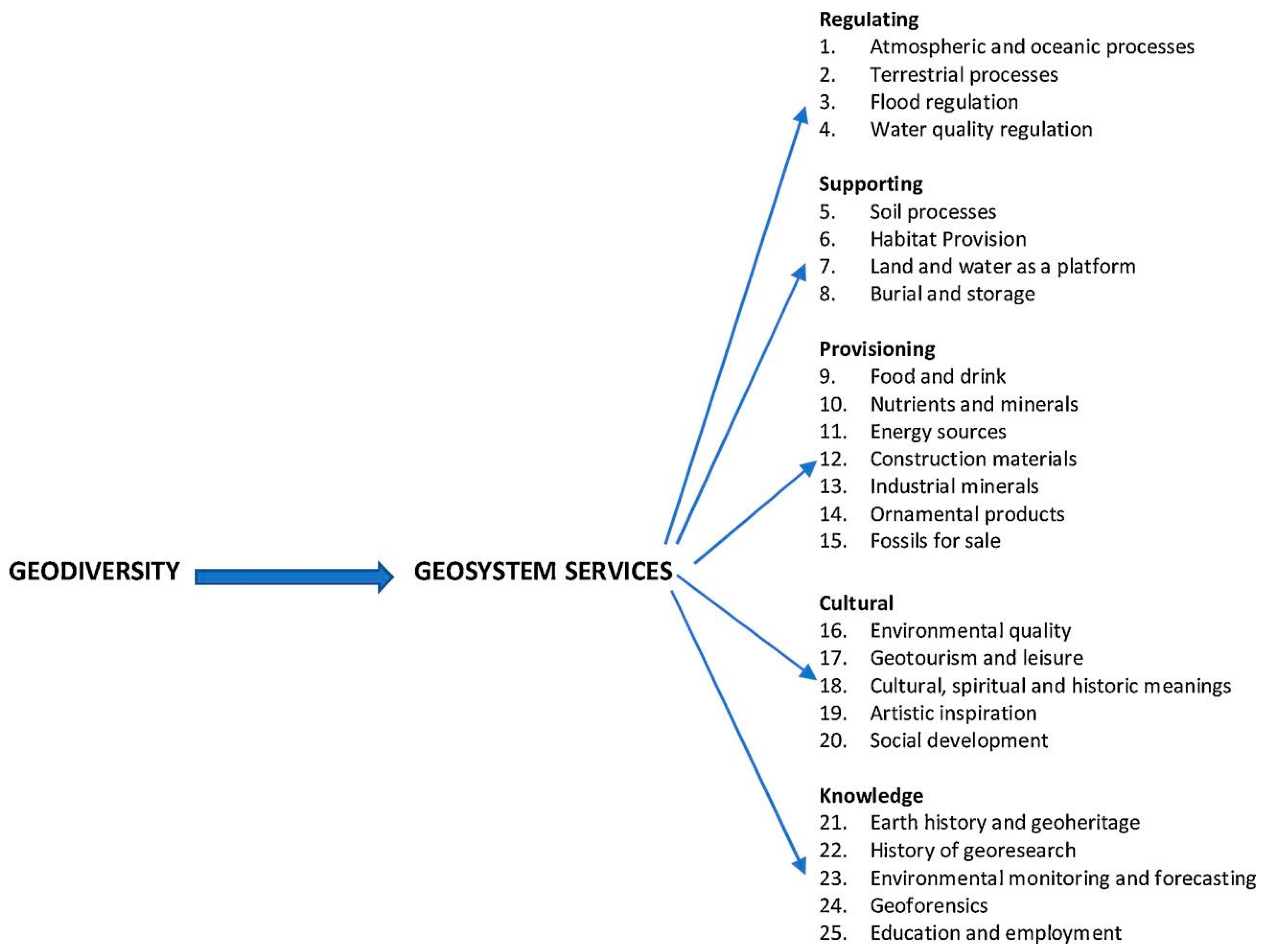


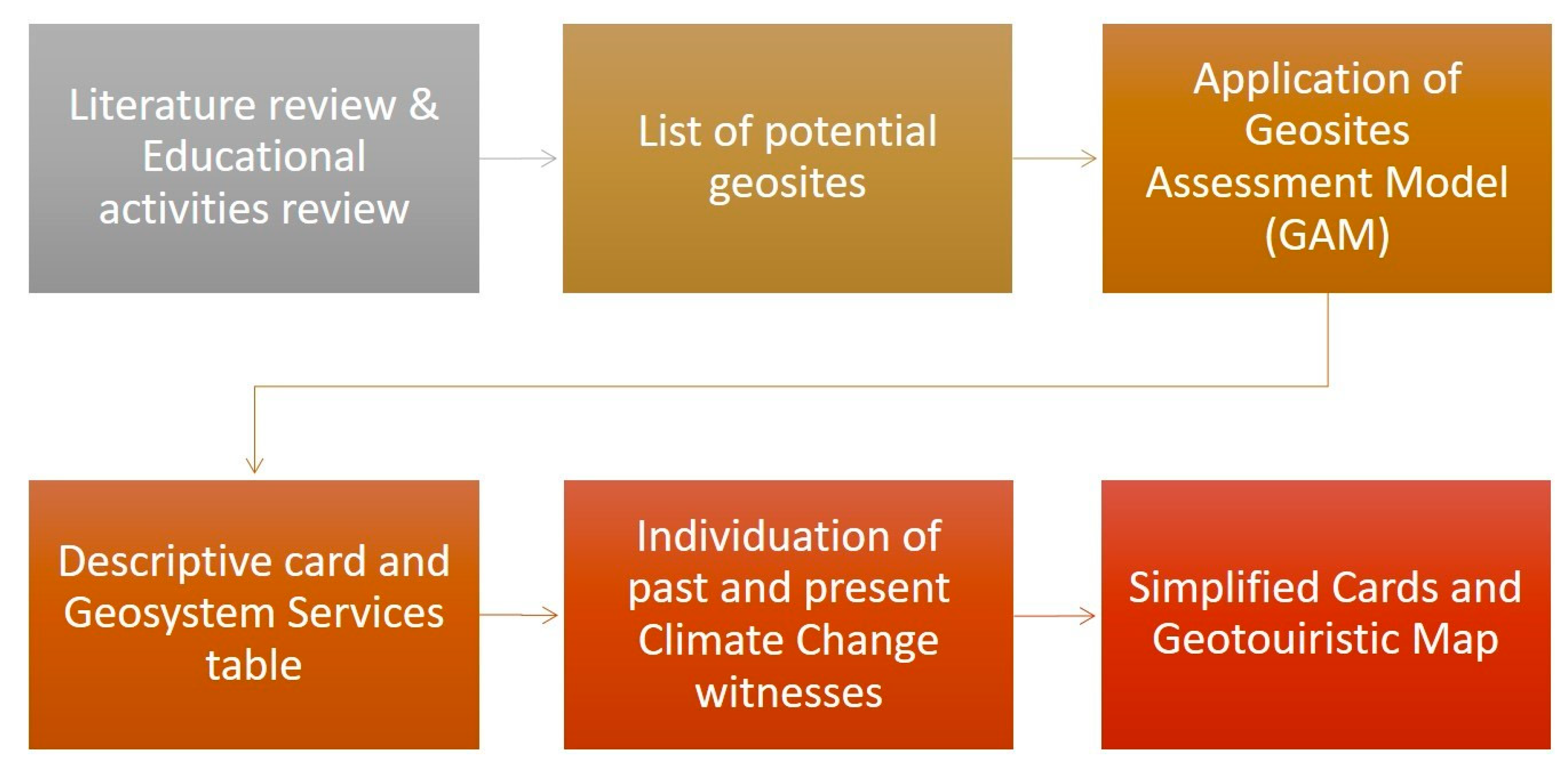
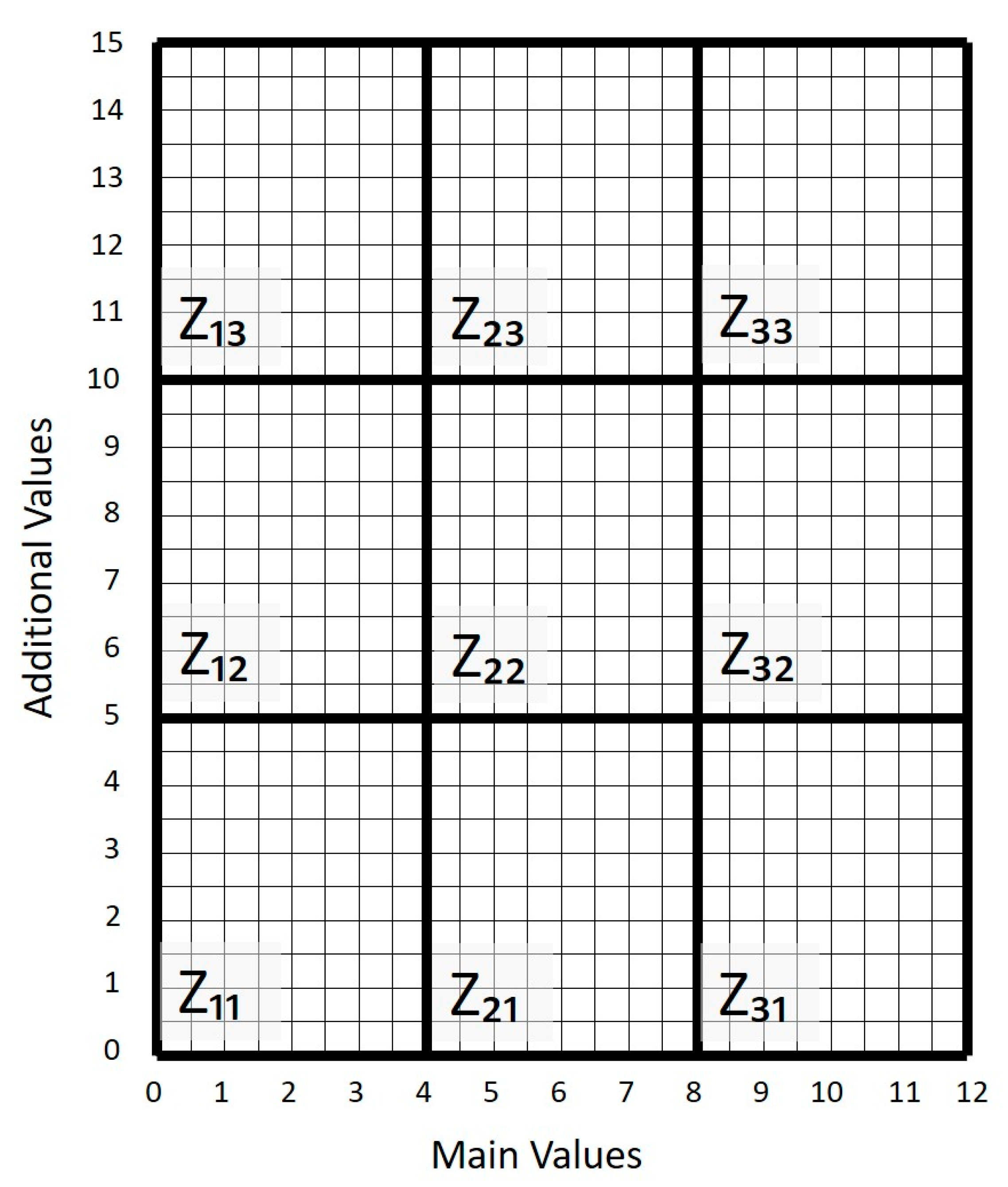
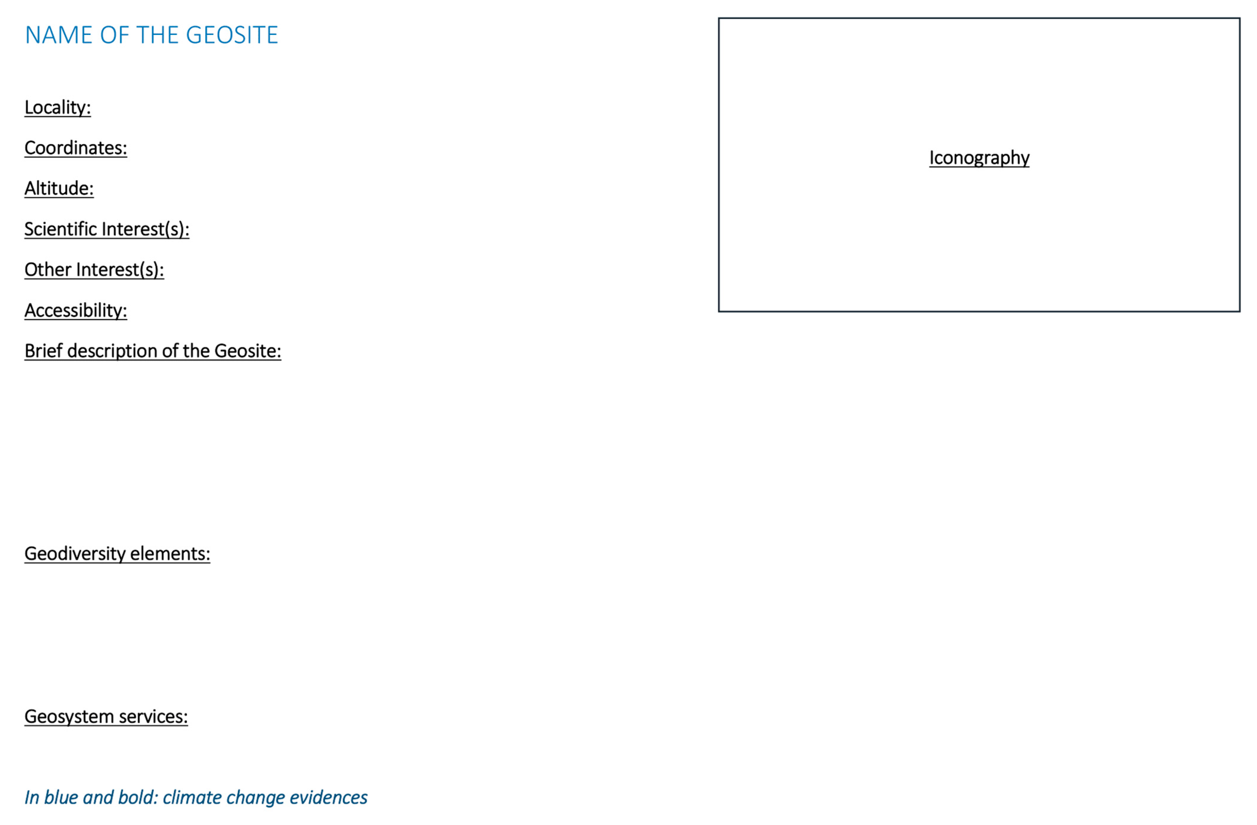
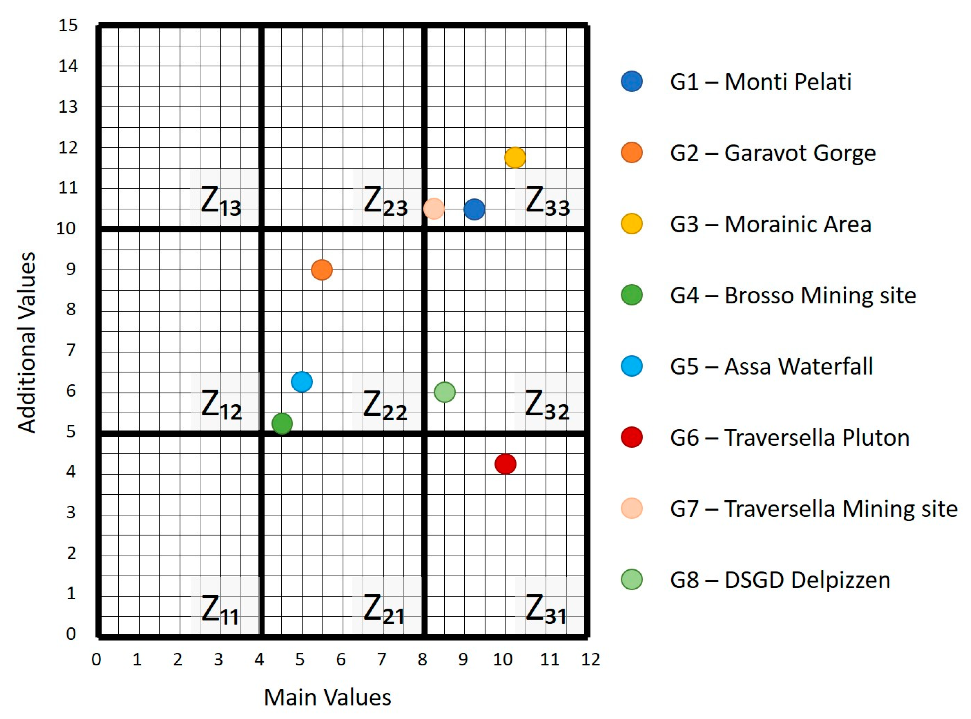
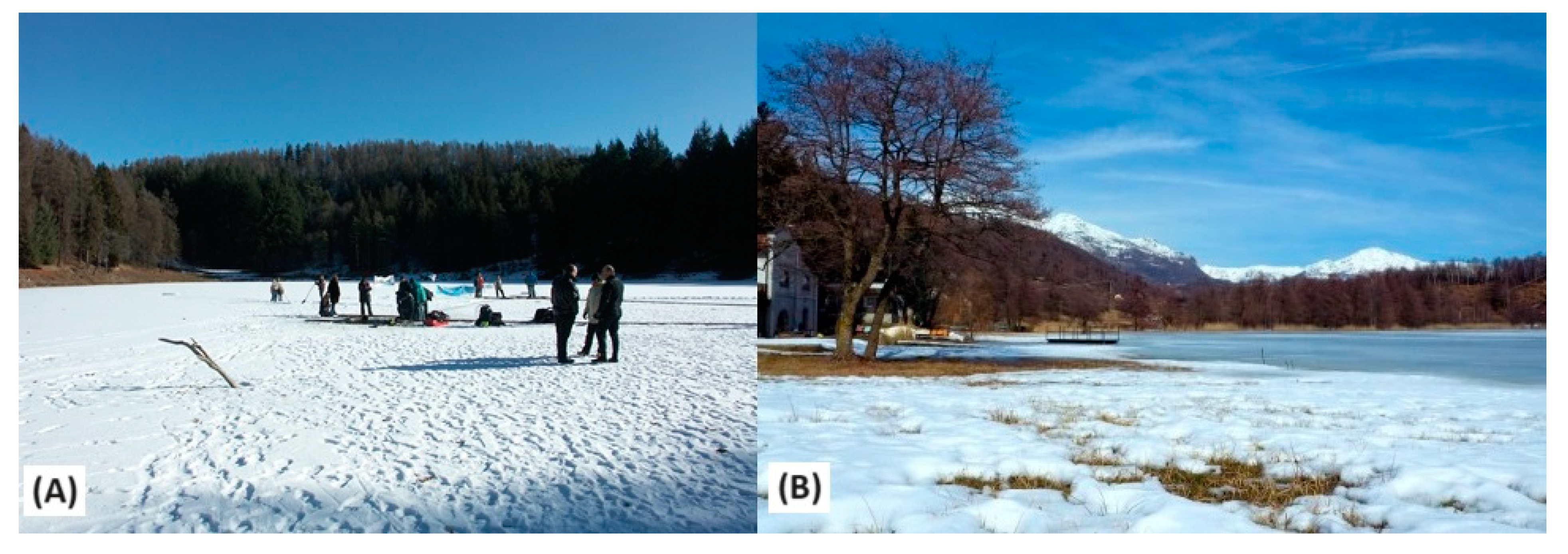

Disclaimer/Publisher’s Note: The statements, opinions and data contained in all publications are solely those of the individual author(s) and contributor(s) and not of MDPI and/or the editor(s). MDPI and/or the editor(s) disclaim responsibility for any injury to people or property resulting from any ideas, methods, instructions or products referred to in the content. |
© 2024 by the authors. Licensee MDPI, Basel, Switzerland. This article is an open access article distributed under the terms and conditions of the Creative Commons Attribution (CC BY) license (https://creativecommons.org/licenses/by/4.0/).