Constructing a Virtual Environment for Multibody Simulation Software Using Photogrammetry


Abstract
:
1. Introduction
2. Methodology
Photogrammetry Approach
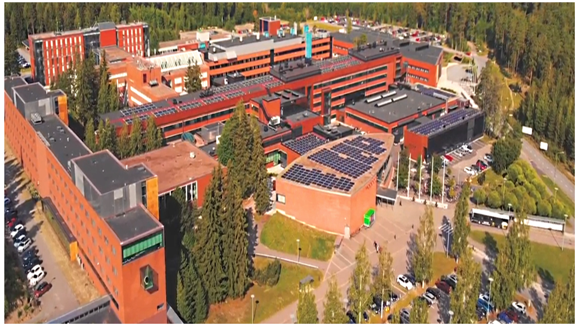
3. Example Case
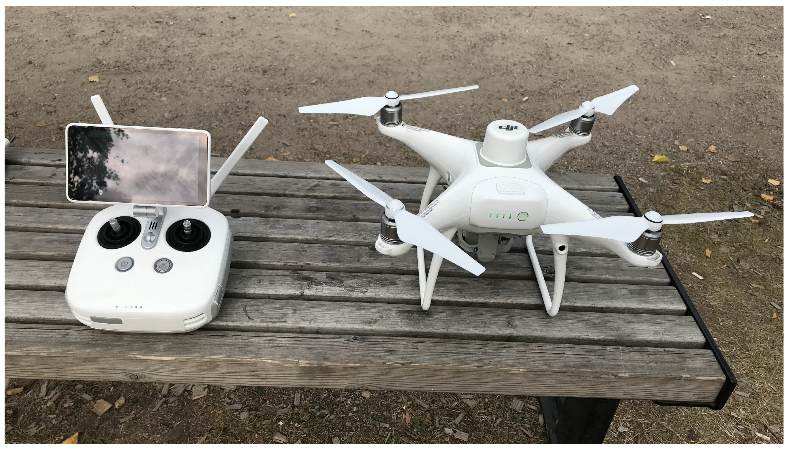
3.1. Equipment
3.2. Procedure for Three Dimensional Environment
4. Discussion
5. Conclusions
Author Contributions
Funding
Conflicts of Interest
References
- Yang, C.W.; Lee, T.H.; Huang, C.L.; Hsu, K.S. Unity 3D Production and Environmental Perception Vehicle Simulation Platform. In Proceedings of the IEEE 2016 International Conference on Advanced Materials for Science and Engineering (ICAMSE), Tainan, Taiwan, 12–13 November 2016; pp. 452–455. [Google Scholar]
- Vajak, D.; Livada, Č. Combining Photogrammetry, 3D Modeling and Real Time Information Gathering for Highly Immersive VR Experience. In Proceedings of the IEEE 2017 Zooming Innovation in Consumer Electronics International Conference (ZINC), Novi Sad, Serbia, 31 May–1 June 2017; pp. 82–85. [Google Scholar]
- Fritsch, D.; Klein, M. 3D Preservation of Buildings–Reconstructing the Past. Multimed. Tools. Appl. 2018, 77, 9153–9170. [Google Scholar] [CrossRef]
- Mach, V.; Valouch, J.; Adámek, M.; Ševčík, J. Virtual Reality–Level of Immersion Within the Crime Investigation. In MATEC Web of Conferences; EDP Sciences: Zlín, Czech Republic, 2019; Volume 292, p. 01031. [Google Scholar]
- Chiu, Y.P.; Shiau, Y.C.; Song, S.J. A Study on Simulating Landslides Using Unity Software. In Applied Mechanics and Materials; Trans Tech Publications Ltd.: Baech, Switzerland, 2015; Volume 764, pp. 806–811. [Google Scholar]
- Isar, C. A Glance into Virtual Reality Development Using Unity. Inf. Econom. 2018, 22. [Google Scholar] [CrossRef]
- Uggla, G. 3D City Models-A Comparative Study of Methods and Datasets. Master’s Thesis, School of Architecture and the Built Environment Royal Institute of Technology (KTH), Stockholm, Sweden, 2015. [Google Scholar]
- Oqua, O.I.; Chen, J.; Annamalai, A.; Yang, C. 3D Printed Data Glove Design for VR Based Hand Gesture Recognition. In Proceedings of the IEEE 2018 11th International Workshop on Human Friendly Robotics (HFR), Shenzhen, China, 13–14 November 2018; pp. 66–71. [Google Scholar]
- Brady, D.; Lee, A.; Pearce, A.; Shintaku, N.; Guerlain, S. Intelligent Cities: Translating Architectural Models Into a Virtual Gaming Environment for Event Simulation. In Proceedings of the IEEE 2015 Systems and Information Engineering Design Symposium, Charlottesville, VA, USA, 24 April 2015; pp. 369–373. [Google Scholar]
- Silva, J.F.; Almeida, J.E.; Rossetti, R.J.; Coelho, A.L. A Serious Game for EVAcuation Training. In Proceedings of the 2013 IEEE 2nd International Conference on Serious Games and Applications for Health (SeGAH), Vilamoura, Portugal, 2–3 May 2013; pp. 1–6. [Google Scholar]
- Chittaro, L.; Ranon, R. Serious Games for Training Occupants of a Building in Personal Fire Safety Skills. In Proceedings of the IEEE 2009 Conference in Games and Virtual Worlds for Serious Applications, Coventry, UK, 23–24 March 2009; pp. 76–83. [Google Scholar]
- Bhide, S.; Riad, R.; Rabelo, L.; Pastrana, J.; Katsarsky, A.; Ford, C. Development of Virtual Reality Environment for Safety Training. In Proceedings of the IIE Annual Conference, Orlando, FL, USA, 19–23 May 2015; Institute of Industrial and Systems Engineers-Publisher (IISE): Norcross, GA, USA, 2015; p. 2302. [Google Scholar]
- Sacks, R.; Perlman, A.; Barak, R. Construction Safety Training Using Immersive Virtual Reality. Constr. Manag. Econ. 2013, 31, 1005–1017. [Google Scholar] [CrossRef]
- Friend, M.A.; Kohn, J.P. Fundamentals of Occupational Safety and Health; Rowman & Littlefield: Lanham, MD, USA, 2018. [Google Scholar]
- Birt, J.; Stromberga, Z.; Cowling, M.; Moro, C. Mobile Mixed Reality for Experiential Learning and Simulation in Medical and Health Sciences Education. Information 2018, 9, 31. [Google Scholar] [CrossRef] [Green Version]
- Wang, Y.; Yang, L.; Zhao, L.; Deng, Y. Design of Simulation Training System for Remote Sensing Large Data Processing of Natural Disasters. J. Coast. Res. 2018, 83, 328–334. [Google Scholar] [CrossRef]
- Chou, Y.T.; Lee, B.W.; Shih, H.Y. Study on Educational Virtual Reality Implementation Using Knowledge-Based Engineering. In Proceedings of the 2018 IEEE International Conference on Advanced Manufacturing (ICAM), Yunlin, Taiwan, 16–18 November 2018; pp. 433–436. [Google Scholar]
- ISPRM. International Society of Photogrammetry and Remote Sensing. 2019. Available online: https://www.isprs.org (accessed on 10 January 2020).
- Mikhail, E.M.; Bethel, J.S.; McGlone, J.C. Introduction to Modern Photogrammetry. New York 2001, 19. [Google Scholar]
- Linder, W. Digital Photogrammetry; Springer: Berlin, Germany, 2009. [Google Scholar]
- Whiteman, T.; Lichti, D.; Chandler, I. Measurement of Deflections in Concrete Beams by Close-Range Digital Photogrammetry. In Proceedings of the Symposium on Geospatial Theory, Processing and Applications, Ottawa, ON, Canada, 9–12 July 2002; pp. 9–12. [Google Scholar]
- Fraser, C. Automated Off-Line Digital Close-Range Photogrammetry: Capabilities & Application. In Proceedings of the 3rd International Image Sensing Seminar on New Developments in Digital Photogrammetry, Gifu, Japan, 24–27 September 2001. [Google Scholar]
- Fraser, C.S.; Riedel, B. Monitoring the Thermal Deformation of Steel Beams via Vision Metrology. ISPRS J. Photogramm. Remote. Sens. 2000, 55, 268–276. [Google Scholar] [CrossRef] [Green Version]
- Jáuregui, D.V.; White, K.R.; Woodward, C.B.; Leitch, K.R. Noncontact Photogrammetric Measurement of Vertical Bridge Deflection. J. Bridge. Eng. 2003, 8, 212–222. [Google Scholar] [CrossRef]
- Rieke-Zapp, D.; Wegmann, H.; Santel, F.; Nearing, M. Digital Photogrammetry for Measuring Soil Surface Roughness. In Proceedings of the American Society of Photogrammetry & Remote Sensing 2001 Conference–Gateway to the New Millennium’, St Louis, MO, USA, 23–27 April 2001; American Society of Photogrammetry & Remote Sensing: Bethesda, MD, USA, 2001. [Google Scholar]
- Remondino, F.; Rizzi, A. Reality-Based 3D Documentation of Natural and Cultural Heritage Sites—Techniques, Problems, and Examples. Appl. Geomater. 2010, 2, 85–100. [Google Scholar] [CrossRef] [Green Version]
- Esmaeili, H.; Thwaites, H.; Woods, P.C. Workflows and Challenges Involved in Creation of Realistic Immersive Virtual Museum, Heritage, and Tourism Experiences: A Comprehensive Reference for 3D Asset Capturing. In Proceedings of the IEEE 2017 13th International Conference on Signal-Image Technology & Internet-Based Systems (SITIS), Jaipur, India, 4–7 December 2017; pp. 465–472. [Google Scholar]
- Smith, M.J.; Hamruni, A.M.; Jamieson, A. 3-D Urban Modelling Using Airborne Oblique and Vertical Imagery. In Proceedings of the ISPRS Hannover Workshop, Hannover, Germany, 2–5 June 2009. [Google Scholar]
- Hashim, K.A.; Ahmad, A.; Samad, A.M.; NizamTahar, K.; Udin, W.S. Integration of Low Altitude Aerial & Terrestrial Photogrammetry Data in 3D Heritage Building Modeling. In Proceedings of the 2012 IEEE Control and System Graduate Research Colloquium, Selangor, Malaysia, 16–17 July 2012; pp. 225–230. [Google Scholar]
- Rodríguez-Cielos, R.; Galán-García, J.L.; Padilla-Domínguez, Y.; Rodríguez-Cielos, P.; Bello-Patricio, A.B.; López-Medina, J.A. LiDARgrammetry: A New Method for Generating Synthetic Stereoscopic Products from Digital Elevation Models. Appl. Sci. 2017, 7, 906. [Google Scholar] [CrossRef] [Green Version]
- Macher, H.; Landes, T.; Grussenmeyer, P. From point clouds to building information models: 3D semi-automatic reconstruction of indoors of existing buildings. Appl. Sci. 2017, 7, 1030. [Google Scholar] [CrossRef] [Green Version]
- Yi, X.; Zhang, R.; Li, H.; Chen, Y. An MFF-SLIC Hybrid Superpixel Segmentation Method with Multi-Source RS Data for Rock Surface Extraction. Appl. Sci. 2019, 9, 906. [Google Scholar] [CrossRef] [Green Version]
- Masiero, A.; Fissore, F.; Guarnieri, A.; Pirotti, F.; Visintini, D.; Vettore, A. Performance evaluation of two indoor mapping systems: Low-cost UWB-aided photogrammetry and backpack laser scanning. Appl. Sci. 2018, 8, 416. [Google Scholar] [CrossRef] [Green Version]
- Dabove, P.; Grasso, N.; Piras, M. Smartphone-Based Photogrammetry for the 3D Modeling of a Geomorphological Structure. Appl. Sci. 2019, 9, 3884. [Google Scholar] [CrossRef] [Green Version]
- Wang, Q.; Zhao, H.; Zhang, Z.; Cui, X.; Ullah, S.; Sun, S.; Liu, F. Line matching based on viewpoint-invariance for stereo wide-baseline aerial images. Appl. Sci. 2018, 8, 938. [Google Scholar] [CrossRef] [Green Version]
- Manajitprasert, S.; Tripathi, N.K.; Arunplod, S. Three-Dimensional (3D) Modeling of Cultural Heritage Site Using UAV Imagery: A Case Study of the Pagodas in Wat Maha That, Thailand. Appl. Sci. 2019, 9, 3640. [Google Scholar] [CrossRef] [Green Version]
- Soto-Martin, O.; Fuentes-Porto, A.; Martin-Gutierrez, J. A Digital Reconstruction of a Historical Building and Virtual Reintegration of Mural Paintings to Create an Interactive and Immersive Experience in Virtual Reality. Appl. Sci. 2020, 10, 597. [Google Scholar] [CrossRef] [Green Version]
- Obradović, M.; Vasiljević, I.; Đurić, I.; Kićanović, J.; Stojaković, V.; Obradović, R. Virtual Reality Models Based on Photogrammetric Surveys—A Case Study of the Iconostasis of the Serbian Orthodox Cathedral Church of Saint Nicholas in Sremski Karlovci (Serbia). Appl. Sci. 2020, 10, 2743. [Google Scholar] [CrossRef]
- Valença, J.; Julio, E.; Araújo, H. Applications of Photogrammetry to Structural Assessment. Exp. Tech. 2012, 36, 71–81. [Google Scholar] [CrossRef]
- Baltsavias, E.P. A Comparison Between Photogrammetry and Laser Scanning. ISPRS J. Photogramm. Remote. Sens. 1999, 54, 83–94. [Google Scholar] [CrossRef]
- Vosselman, G.; Maas, H.G. Airborne and Terrestrial Laser Scanning; CRC Press: Boca Raton, FL, USA, 2010. [Google Scholar]
- Barsanti, S.G.; Remondino, F.; Visintini, D. Photogrammetry and Laser Scanning for Archaeological Site 3D Modeling–Some Critical Issues. In Proceedings of the 2nd Workshop on ’The New Technologies for Aquileia’, Aquileia, Italy, 25 June 2012. [Google Scholar]
- Lerma, J.L.; Navarro, S.; Cabrelles, M.; Villaverde, V. Terrestrial laser scanning and close range photogrammetry for 3D archaeological documentation: The Upper Palaeolithic Cave of Parpalló as a case study. J. Archaeol. Sci. 2010, 37, 499–507. [Google Scholar] [CrossRef]
- Moon, D.; Chung, S.; Kwon, S.; Seo, J.; Shin, J. Comparison and utilization of point cloud generated from photogrammetry and laser scanning: 3D world model for smart heavy equipment planning. Autom. Constr. 2019, 98, 322–331. [Google Scholar] [CrossRef]
- Xu, Z.; Wu, L.; Shen, Y.; Li, F.; Wang, Q.; Wang, R. Tridimensional reconstruction applied to cultural heritage with the use of camera-equipped UAV and terrestrial laser scanner. Remote Sens. 2014, 6, 10413–10434. [Google Scholar] [CrossRef] [Green Version]
- Meroño, J.E.; Perea, A.J.; Aguilera, M.J.; Laguna, A.M. Recognition of materials and damage on historical buildings using digital image classification. S. Afr. J. Sci. 2015, 111, 1–9. [Google Scholar] [CrossRef] [Green Version]
- Nouwakpo, S.K.; Weltz, M.A.; McGwire, K. Assessing the performance of structure-from-motion photogrammetry and terrestrial LiDAR for reconstructing soil surface microtopography of naturally vegetated plots. Earth Surf. Process. Landf. 2016, 41, 308–322. [Google Scholar] [CrossRef]
- Lu, Q.; Lee, S. Image-based technologies for constructing as-is building information models for existing buildings. J. Comput. Civ. Eng. 2017, 31, 04017005. [Google Scholar] [CrossRef]
- Pătrăucean, V.; Armeni, I.; Nahangi, M.; Yeung, J.; Brilakis, I.; Haas, C. State of research in automatic as-built modeling. Adv. Eng. Inform. 2015, 29, 162–171. [Google Scholar] [CrossRef] [Green Version]
- Wang, Q.; Kim, M.K. Applications of 3D point cloud data in the construction industry: A fifteen-year review from 2004 to 2018. Adv. Eng. Inform. 2019, 39, 306–319. [Google Scholar] [CrossRef]
- Burkart, A.; Cogliati, S.; Schickling, A.; Rascher, U. A Novel UAV-Based Ultra-Light Weight Spectrometer for Field Spectroscopy. IEEE Sens. J. 2013, 14, 62–67. [Google Scholar] [CrossRef]
- Eisenbeiß, H. UAV Photogrammetry. Ph.D. Thesis, ETH Zurich, Zurich, Switzerland, 2009. [Google Scholar]
- Atkinson, K.B. Close Range Photogrammetry and Machine Vision; Whittles Publishing: Dunbeath, UK, 1996. [Google Scholar]
- Yu, I.; Mortensen, J.; Khanna, P.; Spanlang, B.; Slater, M. Visual Realism Enhances Realistic Response in an Immersive Virtual Environment-Part 2. IEEE Comput. Graph. Appl. 2012, 32, 36–45. [Google Scholar] [CrossRef] [Green Version]
- Nikolakopoulos, K.G.; Soura, K.; Koukouvelas, I.K.; Argyropoulos, N.G. UAV vs Classical Aerial Photogrammetry for Archaeological Studies. J. Archaeol. Sci. Rep. 2017, 14, 758–773. [Google Scholar] [CrossRef]
- Watton, J. Modeling, Simulation, Analog and Microcomputer Control; Prentice-Hall, Inc.: Upper Saddle River, NJ, USA, 1989. [Google Scholar]
- Slaats, P.M. Recursive Formulations in Multibody Dynamics; Technische Universiteit Eindhoven: Eindhoven, The Netherlands, 1991. [Google Scholar]
- Yang, X.; Shen, Y. Runge–Kutta Method for Solving Uncertain Differential Equations. J. Unce. Anal. Appl. 2015, 3, 1–12. [Google Scholar] [CrossRef] [Green Version]


© 2020 by the authors. Licensee MDPI, Basel, Switzerland. This article is an open access article distributed under the terms and conditions of the Creative Commons Attribution (CC BY) license (http://creativecommons.org/licenses/by/4.0/).
Share and Cite
Mohammadi, M.; Eskola, R.; Mikkola, A. Constructing a Virtual Environment for Multibody Simulation Software Using Photogrammetry. Appl. Sci. 2020, 10, 4079. https://doi.org/10.3390/app10124079
Mohammadi M, Eskola R, Mikkola A. Constructing a Virtual Environment for Multibody Simulation Software Using Photogrammetry. Applied Sciences. 2020; 10(12):4079. https://doi.org/10.3390/app10124079
Chicago/Turabian StyleMohammadi, Manouchehr, Roope Eskola, and Aki Mikkola. 2020. "Constructing a Virtual Environment for Multibody Simulation Software Using Photogrammetry" Applied Sciences 10, no. 12: 4079. https://doi.org/10.3390/app10124079