Article

Evolution of Depositional Environments in Response to the Holocene Sea-Level Change in the Lower Delta Plain of Nakdong River Delta, Korea

1
Department of Oceanography & Ocean Environmental Sciences, Chungnam National University, Daejeon 34134, Korea
2
Department of Geology, Kangwon National University, Chuncheon 24341, Korea
3
Geology Division, Korea Institute of Geoscience and Mineral Resources, Daejeon 34132, Korea
4
Department of Geological Sciences, Pusan National University, Busan 46241, Korea
*
Author to whom correspondence should be addressed.
Appl. Sci. 2022, 12(1), 177; https://doi.org/10.3390/app12010177
Submission received: 12 November 2021 / Revised: 8 December 2021 / Accepted: 21 December 2021 / Published: 24 December 2021

Abstract

:
The Nakdong River delta, located in southeastern Korea, preserves thick and wide sediments, which are suitable for the high-resolution study of the evolution of depositional environments in the lower delta plain area. This study traces the Holocene evolution of the Nakdong River delta using deep drill core (ND-3; 46.60 m thick) sediments from the present delta plain. Sedimentary units of the sediments were classified based on grain size compositions and sedimentary structures: (A) alluvial zone, (B) estuarine zone, (C) shallow marine, (D) prodelta, (E) delta front, and (F) delta plain. The weathered sediment, paleosol, was observed at 43.16 m below the surface. There is an unconformity (43.10 m) to separate a Pleistocene sediment layer in the lowermost part differentiating from a Holocene sediment layer in the upper part of the core. The shallow marine sedimentary unit (32.20~23.50 m), in which grain size decreases upward is overlain by the prodelta unit (23.50~15.10 m), which consists of fine-grained sediments and relatively homogeneous sedimentary facies. The boundary between the delta front unit (15.10~8.00 m) and the delta plain unit (8.00~0.00 m) appears to lie at 8.0 m, and the variation in grain size is different; coarsening upward in the delta front unit and fining upward in the delta front unit, respectively. These sediments are characterized by a lot of sand–mud couplets and mica flakes aligned along with cross-stratification, which may be deposited in relatively high-energy environments. Until 13 cal ka BP, the sea level was 70 m below the present level and the drilling site might be located onshore. At 10 cal ka BP, the sea level was located 50 m below the present level and the drilling site might be moved to an estuarine environment. From 8 to 6 cal ka BP, a transgression phase occurred as a result of coastline invasion by the rapid rise of the sea level. Thus, the drilling site was drowned in a shallow marine environment. After 6 cal ka BP, the sea level reached the present level, and, since then, progradation might begin to form, primarily by more sediment input. After this period, the progradation phase continues as the sediments have advanced and the delta grows.

1. Introduction

Sea-level change, sediment supply, and accommodation are three major factors of river delta evolution [1]. As the sea level has risen since the Last Glacial Maximum (LGM), the accommodation space of the coastal area has increased. During the last 7–6 ka years, where sea level has been stable or slightly fallen in stages, the sediment discharge from the land to the ocean has increased and many river deltas have been formed [2,3]. Therefore, deltas have become the most important depocenter of the Holocene, and many delta evolution studies have been conducted in the world. Asian deltaic sediments can provide high-resolution information about the paleoenvironmental evolution because they are supplied with large amounts of terrestrial sediments, which are well preserved under the present delta plain [4]. Many studies have been carried out on the effects of sea-level change on the evolution of the deltas in the Yangtze and Pearl rivers in China and those of the Red and Mekong rivers in Vietnam [3,4,5,6,7,8,9,10,11,12].
In the Nakdong River delta, located in southeastern Korea, the paleoenvironmental evolution related to Holocene sea-level change has been extensively studied [13,14,15,16,17,18]. Previous studies in the Nakdong River delta have mainly focused on the early delta initiation process based on the upstream sediments [15,19,20]. Moreover, the depositional environment changes have been studied based on the sedimentary characteristics of a series of drill cores: the OW-1 core sediments, located on the eastern side of the middle-upper area [21]; the ND-1 core sediments, located in the southwest delta plain [17,18]; the ND-2 core sediments [18], located in the sand bar of the downstream area of the Nakdong River delta (Figure 1). Recently, Jeong et al. [22] interpreted the depositional environment change of the downstream core sediments (KND-3) since the LGM using description of the sedimentary facies. Yoo et al. [23] discussed the depositional history of the Nakdong River delta using grain size data, dating, and seismic profiles of the present prodelta core sediments (SSDP-102).
However, to understand the overall evolution of the Nakdong River delta, it is necessary to study the horizontal and vertical variations among the cores further. As the sea level has risen and stabilized since the LGM, the potential accommodation space of the Nakdong River mouth has changed accordingly. The change in accommodation due to the sea-level rise may have been different for each area because the basal topography of the Nakdong River delta was not flat. The core sediments of the present delta plain in the Nakdong River can provide high-resolution data for the sedimentary features, sequence, and, especially, the delta evolution in response to sea-level change.
The aim of this study is to reveal the Holocene depositional environment change of the downstream drilling core sediments (ND-3; 46.60 m thick), and the longitudinal and cross-sectional study of the Nakdong River delta. To achieve this aim, we describe the sedimentary facies, analyze the grain size, and the age of sediments.

2. Regional Setting

The Nakdong River is divided into the eastern Nakdong River and the western Nakdong River by the delta plain between them (Figure 1). The Nakdong River is dammed by an artificial floodgate, and most of the freshwater now flows to the eastern Nakdong River [24]. With a length of 525 km and area of 23,860 km2 [19], the Nakdong River discharges from approximately 50 tributaries, including the Nam River, Miryang River, and Geumho River [18]. Annual freshwater discharge of the Nakdong River is 63 billion tons along with 4.6 million tons of sediments, which are delivered into the Nakdong River delta [25].
The Nakdong River delta is situated on a large plain consisting of deltaic barrier islands and back swamps around the delta coast (Figure 1) [26]. The Nakdong River delta is located along a typical ria coast with many islands. The delta is distributed locally in an intertidal zone and contains various sand bar and barrier islands (e.g., Eulsukdo, Daemadeung, Jangjado, Sinjado, Jinwoodo, and Baekhapdeung) [27]. The present delta plain in the Nakdong River delta is fairly flat and has an altitude of 0~6 m. The present upper delta plain is composed of natural levees and is mainly influenced by the river, and the present lower delta plain is mainly influenced by the sea and is composed of an intertidal zone, barrier islands, and a coastal plain (Figure 1b) [23,24]. The water depth of the present delta front that developed in the offshore is 0~20 m [23]. The tidal range in this area is 1.2 m in average and increases slightly westward [25].
The downstream section of the Nakdong River has a low gradient and is considerably mixed with sea water during high tide because of the intrusion of the salt wedge. To preserve the freshwater resource, the Nakdong River Estuary Bank was built around Eulsukdo; this affected the sedimentary environment in the Nakdong River delta by decreasing the sediment supply to the downstream of the Nakdong River Delta, and the enhanced effects of waves [26,28].

3. Materials and Methods

The ND-3 sediment core, which is used in this study, was drilled at 128°53′04.90″ E, 35°04′03.76″ N in Jinwoodo, a downstream barrier island that contacts the western Nakdong River (Figure 1). The ND-3 sediment core was drilled using a rotary drilling tool, and sediment recovery was more than 90%. The sediment core was split into two halves, and an archive half core was sealed and stored in a refrigerator. A working half was photographed, and sedimentary structure and sediment color were described. Subsequently, 1-cm-thick subsample was collected at 1 cm interval for analyses of grain size and age dates.

3.1. Age Dating

Age dating was taken for all nine horizons at the Korea Institute of Geoscience and Mineral Resources. The three horizons among them in the upper sand sediments were analyzed by accelerator mass spectrometry (AMS) for calcareous shells (e.g., shell fragments and oyster shells). AMS 14C dating for all the samples were conducted in the accelerator mass spectrometry laboratory of the Korea Institute of Geoscience and Mineral Resources and calibrated to calendar years using OxCal 4.2.4 with a 1σ level of reliability [29,30]. Optically stimulated luminescence (OSL) dating was performed for the remaining six horizons, which consisted of the muddy sediment from the bottom of the core. For the dating of the fine-grained samples, chemically purified quartz grains 4–11 μm in diameter were extracted using sodium pyrophosphate (Na4P2O7·10H2O) to remove any clay, and hydrochloric acid (HCl) and hydrogen peroxide (H2O2) to remove any carbonates and organic matter. Settling occurred according to Stokes’ law over a depth of 20 cm in a 0.01 M sodium oxalate (Na2C2O4) solution. Finally, the samples were etched in hydrofluorosilicic acid (H2SiF6) for 14 days to chemically remove feldspar. Luminescence signals were measured with the LexsygSmart luminescence reader (Freiberg Instruments, Germany) equipped with a blue light-emitting diode (445/458 nm) stimulation source. Irradiation was provided by a 90Sr/90Y beta source delivering approximately 0.15 gray (Gy) s-1. Radionuclide contents were measured using low-level high-resolution gamma spectrometry (Canberra SEGc 3018). Conversion to dose rates was based on the data presented by Olley et al. [31].

3.2. Grain Size Analysis

Grain size analysis was conducted at 10 cm intervals. However, because coarse-grained sediments were lost in the 34.0–43.0 m section during the coring, the total number of analyses was reduced to 345 samples. For each subsample, 7–10 g was pretreated for grain size analysis. To remove the organic matter, the sample was reacted with 35% hydrogen peroxide on a hot plate for one day. The sample was then reacted with 10% hydrochloric acid at 50 °C for one day to remove carbonate particles and washed three times with distilled water. Next, 5% sodium pyrophosphate decahydrate was added, and the sample was ultrasonicated to dismantle mounted grains. Wet sieving was then applied using a 63 μm sieve to separate sand and mud. The muddy sediments were analyzed using a Sedigraph 5120 instrument. The sand was dried in an oven for one to two days, and each sediment size was weighed at 0.5 Φ intervals using an electromagnetic sieve shaker and a sieve set.

4. Results

4.1. Classification of Sedimentary Units

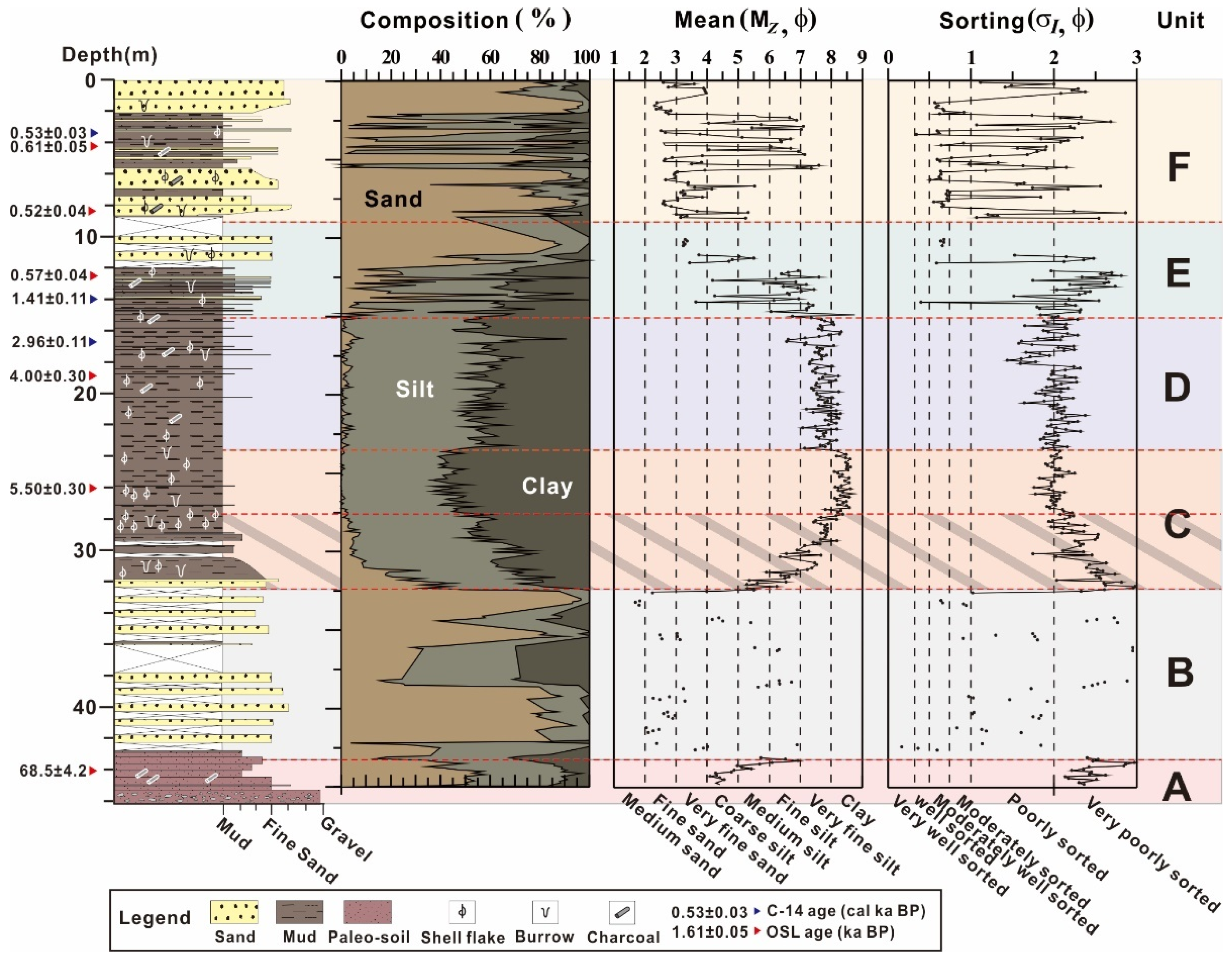
Sediment samples of the ND-3 core are divided into six sedimentary units from the lowest (Unit A) to the uppermost part (Unit F) based on grain size compositions and sedimentary structures. The characteristics of each sedimentary unit are described below.

4.1.1. Unit A (Depth in Core: 46.60–43.16 m)

Unit A is the lowest unit of the sediment core and sediments show a reddish color containing abundant manganese oxide and wood fragments (Figure 2a). The lower part of Unit A (46.60~45.50 m) contains a large number of gravels forming sand-supported gravel layers, and the gravel content decreases upward. Excluding gravels, the average grain size of the sediment also decreases upward (Figure 3). In addition, no foraminiferas, ostracods, or shell fragments were found in the sediments. The upper part of Unit A (45.50~43.16 m) contains a number of wood fragments and shows laminated intervals. The mean grain size of sediments except gravels in Unit A ranges from 4.1 to 6.9 Φ with an average of 5.0 Φ and the sorting is very poor. Excluding gravels, the sediment is composed of 44.5% sand, 41.5% silt, and 14.0% clay.

4.1.2. Unit B (Depth in Core: 43.16–32.20 m)

Unit B mainly consists of sandy sediments, although sandy mud sediment was found in the middle with a thickness of approximately 30~40 cm (Figure 2b). Unit B is generally composed of relatively coarse-grained sediments and does not include foraminiferas, ostracods, or shell fragments. The mean grain size of Unit B shows ranges from 1.7 to 6.9 Φ, with an average of 3.8 Φ, sorting ranges from very good to very poor (Figure 3), and the average contents of sand, silt, and clay are 61.8%, 29.7%, and 8.5%, respectively.

4.1.3. Unit C (Depth in Core: 32.20–23.50 m)

In this unit, the mean grain sizes clearly increase upward, and the clay size is observed in the interval of 27.00~25.00 m (Figure 3). A large amount of shell fragments are also found (Figure 2d) along with wood fragments, a sand layer (Figure 2c), sand lenses, sand–mud couplets, and burrow structures. The sediment color is olive gray and dark gray and becomes lighter toward the upper part. Massive mud appears in the upper part of Unit C (28.00~23.50 m) and the grain size ranges from 5.3 to 8.7 Φ with an average of 7.8 Φ. Sorting is poor to very poor, and the average contents of sand, silt, and clay are 6.3%, 48.0%, and 45.7%, respectively.

4.1.4. Unit D (Depth in Core: 23.50–15.10 m)

According to the grain size data, at the base of Unit D (23.50 m) the silt content increases upward abruptly, while the clay content decreases upward rapidly (Figure 3). The lower part of Unit D is light gray, containing several sand layers. Similar to Unit C, sand layers or shell fragments fill the cracks (Figure 2e). Small shell fragments and burrow structures are observed in Unit D, which consists of relatively more massive muddy sediments as compared to the other sedimentary units (Figure 2e). The upper part of Unit D is olive gray, and a sand layer and burrow structure are also observed. The mean grain size of the Unit D sediments ranges from 6.6 to 8.3 Φ (average = 7.7 Φ) and sorting ranges from poor to very poor. The average contents of sand, silt, and clay are 2.3%, 55.8%, and 41.9%, respectively.

4.1.5. Unit E (Depth in Core: 15.10–8.00 m)

The lower part of Unit E (15.10~12.00 m) is dark gray and shows various sedimentary structures, including sandy layers, sand lenses, cross-stratification (Figure 2f), and burrows. The upper part of Unit E (12.00~8.00 m) is olive gray and composed primarily of sandy sediments; the content of black organic matter is high in this part, and bioturbation (Figure 2g), sand lenses, burrow structures, shell fragments, and a faint stratification are observed. The mean grain size of Unit E shows decreases upward and ranges from 3.0 to 8.8 Φ with an average of 5.7 Φ (Figure 3). The average contents of sand, silt, and clay are 38.7%, 39.1%, and 22.0%, respectively.

4.1.6. Unit F (Depth in Core: 8.00–0.00 m)

The lower part of Unit F (8.00~2.08 m) contains a number of wood fragments and shell fragments, and sand–mud couplets, lenticular bedding, and occasional bright-colored sands with mica flakes are observed (Figure 2h,i). Black organic matter is abundant in the upper part (2.08~0.00 m), and a bioturbation structure, oxidation spot, mud, and wood fragment layer are frequently observed. The boundaries between the muddy and sandy sediments are clearly visible (Figure 2h). The mean grain size of the Unit F sediments ranges from 2.3 to 7.6 Φ (average = 4.1 Φ). The grain size generally shows coarsening upward, although it changes abruptly, and sorting is not good. The average contents of sand, silt, and clay are 64.4%, 27.3%, and 8.3%, respectively.

4.2. Depositional Ages

The ages of ND-3 core sediments were dated at nine horizons by both OSL (Table 1) and AMS 14C dating (Table 2) using shell fragments. These data seem highly reliable because they reproduced the successive younger dates from the bottom to the top of the core. Approximately 68 ka (late Pleistocene) was dated at the lowermost part of the core.
Approximately 6–2 ka was dated in the middle part of the core (26.00–14.00 m), corresponding to the muddy sediments, and the depositional rate of this part was deposited at a rate of approximately 2.9 m/ka, and less than 2 ka in the uppermost part of the core (14.00–0.00) was deposited at a rate of approximately 9.9 m/ka. Although the mud sediments of the middle part of the core are characterized by successive younger ages upward, the uppermost part of the core shows a very high sedimentation rate (Figure 3).

5. Discussion

5.1. Depositional Interpretation of Sedimentary Units

5.1.1. Alluvial Zone

The lowest depositional layer of Unit A (46.60~45.50 m) is the Pleistocene paleosol aged at 68.5 ± 4.2 ka. This layer consists of sandy sediments with a fining upward trend from a lowermost gravel layer. These facies are interpreted as a channel fill sediment [11,12,34]. The abundant organic matter and absence of shell fragments in sediments also support this interpretation. A number of charcoal and sand layers in the upper part of Unit A (45.50~43.16 m) indicate a terrestrial environment because the charcoals and sand layers usually occur in salt marsh and flood plain environments (Figure 4) [12,34]. The reddish soil indicates that the sediments were exposed and oxidized in the subaerial conditions [35]. Thus, Unit A is thought to have been deposited in the terrestrial environment, interpreted as an alluvial setting [36].

5.1.2. Estuarine Zone

Unit B is primarily composed of fine to medium sandy sediments. Any shell fragments with microfossils (foraminiferas and ostracods), which are indicative of marine environments, were not observed. Thus, it can be expected that marine factors were less dominant than terrestrial factors during the deposition of this unit. The Unit B sediments lack age dates but, comparing sedimentary facies such as grain composition with ND-1 core sediments, it is quite similar to the 45.00–50.00 m part of ND-1 core sediments. Cho et al. [37] interpreted 44.25–49.84 m part of the ND-1 core sediment as an estuarine environment through diatom assemblage. This part was mainly composed of abundant freshwater taxa and a few marine-brackish taxa. Therefore, Unit B is interpreted to have been deposited in an estuarine environment where much freshwater from the river channel mixed with seawater [3,15]. In particular, the sandy sediments are interpreted to have been deposited as a bayhead delta, which is a relatively high-energy area located in the first point where the freshwater of the fluvial channel and sea water meet.

5.1.3. Shallow Marine

The age of Unit C is estimated to be approximately 5.5 ka. The shell fragments and microfossils (foraminiferas and ostracods) observed in the sediments indicate an influence of the marine environment. The large number of shell fragment layers and lenticular bedding with sand–mud couplets in the lower and middle part of the Unit C (32.20~28.00 m) are interpreted as a submarine intertidal and subtidal flat environment (Figure 4) [11,12]. The upper part of Unit C (28.00~23.50 m), which shows a fining upward trend and contains shell fragment, is interpreted as an upward deepening inner-shelf environment caused by rapid sea-level rise [34]. Thus, this lower part of Unit C is interpreted as a transition zone from the estuarine zone to the shallow marine rather than the totally marine environment (Figure 4). The upper part of Unit C is interpreted to have been deposited in a shallow marine environment affected by rapid sea-level rise.
A Maximum Flooding Surface (MFS) is defined as the marine flooding surface that separates the transgressive and high-stand system tract. Hori et al. [4] reported that the MFS of the Song Hong delta in Vietnam formed between the estuarine environment, exhibiting sediment retrogradation, and the prodelta environment, showing sediment progradation. Song et al. [10] also described that the retrogradation and progradation phases of the Changjiang delta in China are divided by MFS, and that the fining upward trend is observed beneath MFS, while the coarsening upward trend is observed above MFS. Therefore, the boundary between the fining and coarsening upward sediments of ND-3 at a depth of 28.00 m is interpreted as representing an MFS.

5.1.4. Prodelta

The abrupt change of silt and clay contents at the boundary between Units C and D indicates that the relatively coarse-grained sediments supplied from the terrestrial were not deposited up to this boundary because the rate of sea-level rise was higher than the rate of deposition. Therefore, the relatively coarse-grained riverine sediments did not reach the ND-3 drilling site, and only the relatively fine-grained clay sediments suspending around the ND-3 drilling site were deposited at the ND-3 drilling site. After that, coarse-grained riverine sediments were progradated and deposited at the ND-3 drilling site, resulting in rapid changes in the contents of silt and clay (Figure 3).
Shell fragments and microfossils (foraminiferas and ostracods) are abundant in Unit D, and massive muddy sediment facies is dominant, both of which indicate a relatively strong marine influence [7,38]. However, the grain size analysis result of Unit D shows a slight coarsening upward trend. These data indicate a further terrestrial influence in Unit D in addition to the pre-existing marine influence. Thus, Unit D is interpreted to have been deposited in a prodelta environment in which terrestrial sediments began to be deposited.

5.1.5. Delta Front

The grain size data of Unit E indicate a coarsening upward trend, and the largest mean grain size occurs at a depth of 8.00 m, corresponding to the boundary between Units E and F. At depths shallower than 8.00 m, a fining upward trend is observed (Figure 3). Hori [5] described the change of the grain size trend from coarsening upward to fining upward in the Changjiang river delta as a boundary between delta front and delta plain settings. The cross-stratification of sandy sediments, and mud–sand couplets indicate a deposition by tides [6]. The abundant sand lenses and shell fragments suggest that the sediments resulted from re-sedimentation from the lower unit in a relatively high-energy tide-dominated environment [6,39]. The increase in sand contents and organic materials are common in delta front deposits [6,40]. Therefore, Unit E is interpreted as having been deposited in a delta front environment with rapid sediment progradation.

5.1.6. Delta Plain

Unit F is the uppermost layer of the ND-3 drill core sediment. Its lower part (8.00~2.08 m) is composed of a sand and mud couplet, whereas the upper part (2.08~0.00 m) is composed of a sand sediment. A number of sand–mud couplets and lenticular bedding in the lower part indicate the deposition under a tide-dominated subtidal flat environment with the input of a large number of mica flakes [6]. The upper part of the unit, which shows thick sand beds and a large amount of organic material along with oxidized sediments, is interpreted as an intertidal sand flat environment [6,12]. Thus, the depositional environment of Unit F is considered to have been a delta plain [7].

5.2. Correlation between ND-3, KND-3, and ND-2 Cores in the Lower Delta Plain

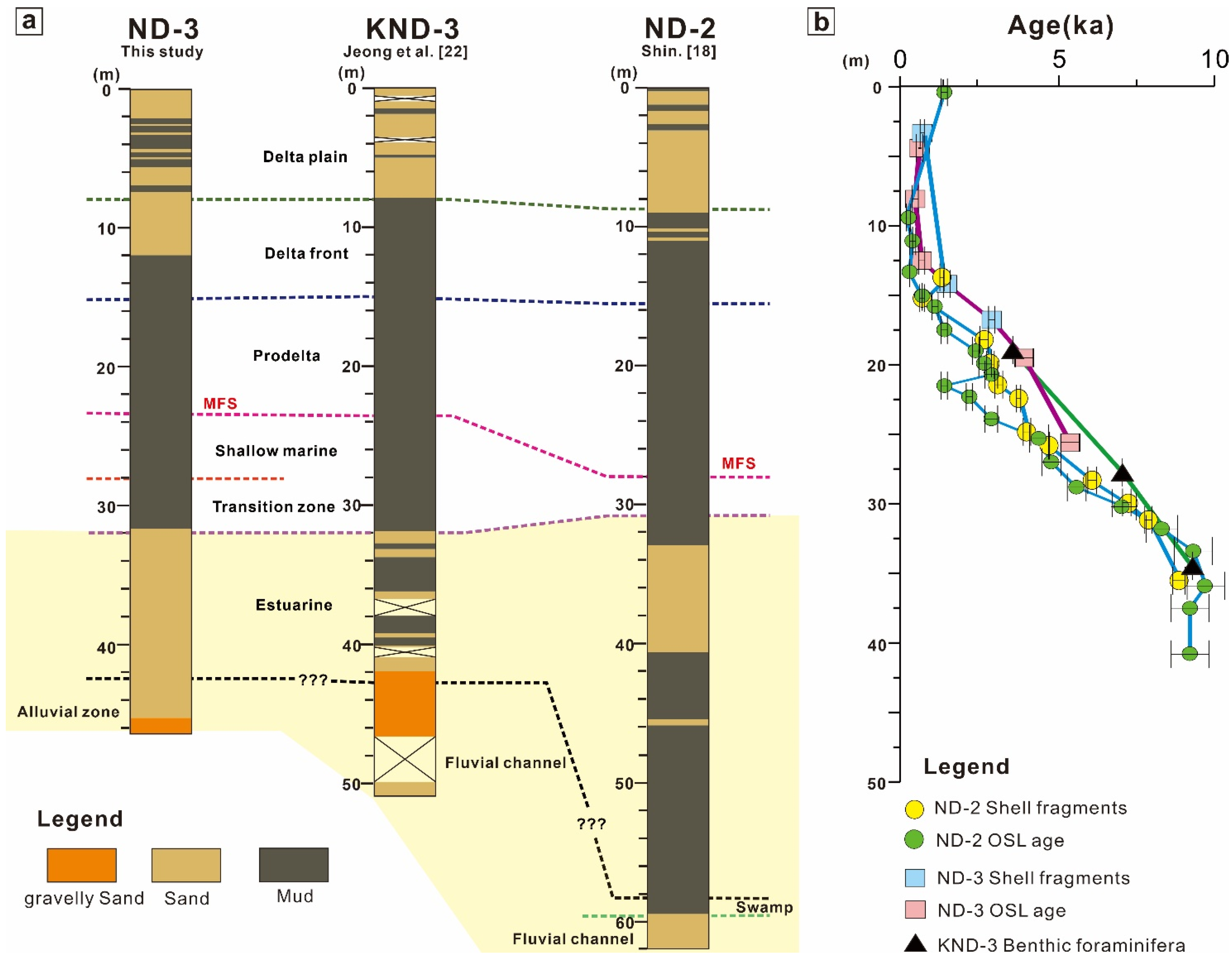
The ND-2 drilling site is located 4 km to the east of ND-3, and the KND-3 drilling site is located between ND-2 and ND-3. All three cores have the same elevation and the core samples from the three sites are obtained with the same drilling method. The analysis results of sedimentary facies in the three core sediments indicate that the paleosols of the ND-3 core appear at a depth of approximately 43.00 m, and the paleosols of the KND-3 and ND-2 core appear at a depth of 50.54 m and 60.00 m, respectively (Figure 5a). This suggests that when the sea level was low, the paleo-topography between the three cores was not flat and the elevation decreased from west to east. In addition, since the Yangsan Fault penetrates along the present Nakdong River channel, an incised valley had probably developed around the fault [18]. This is why core sediments of the ND-2 drilling site in the incised valley are thicker than other core sediments.
The sediments of the three cores in the present lower delta plain show similar patterns at the middle and upper parts (Figure 5a). There are, however, big differences between the three cores at the lowest parts to a depth of approximately 32.00 m. In the sediments, which are interpreted as representing an estuarine environment, the ND-3 core sediments are mainly composed of fine to medium sand, whereas the KND-3 and ND-2 core sediments contain a large amount of mud content. This suggests that the relatively coarse-grained sediments in the ND-3 core are deposited in the bayhead delta setting, which is closer to the channel than the KND-3 and ND-2 core sediments. The lowest sedimentary Unit of the three cores were interpreted as being deposited in different environments (Figure 5a). Since the age at the lowest Unit of the KND-3 and ND-2 core was not measured and each core had different elevations to the former sea level, the three cores cannot be interpreted as being deposited at the same time. However, when the sea level was low, it can be assumed that the three cores were not deposited under the same environment setting.
Since the dating results of the KND-3 core are very few in number, it is difficult to compare them with other cores. The dating results for the ND-2 and ND-3 core sediments show slight differences (Figure 5b). For both cores, the ages of the uppermost parts corresponding to the delta plain are around 0.6–0.5 cal ka BP. However, below a depth of approximately 12.00 m (corresponding to the delta front and prodelta), the ND-3 core sediment is found to be 800 to 1000 years older than the ND-2 core sediments. This indicates that the sediments supplied from the land to the ND-2 and ND-3 drilling sites were not accumulated simultaneously, or even within the same setting, due to topographic difference. The sediment was likely first supplied to the ND-3 area; subsequently, as the elevation of the ND-3 drilling site increased over time, the sediment route changed and sediment was supplied into the ND-2 area by lateral switching.

5.3. Evolution History of the Nakdong River Delta

The evolution of the Nakdong River delta sedimentary environments in response to Holocene sea-level change is analyzed by comparing the data of ND-3 sediments to those of OW-1 [21], ND-1 [18,37], ND-2 [18], and SSDP-102 [41] (Figure 6).

5.3.1. Last Glacial Maximum—6 cal ka BP (Retrogradation Phase)

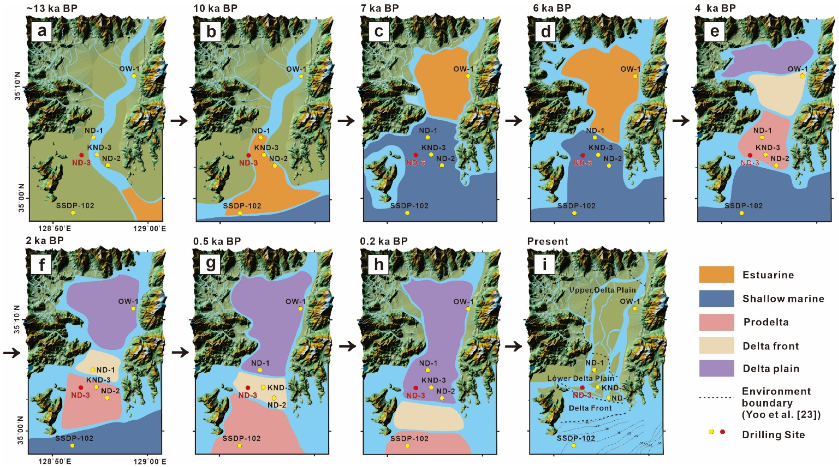
The sea level was lowered by about 120 m below the present level before the LGM at 18 cal ka BP [42,43]. Subsequently, the sea level rose to approximately 70 m below the present level at 13 cal ka BP [42,44,45,46]. Because the seawater could not reach the estuary of the Nakdong River during this period, the OW-1, ND-1, and KND-3 drilling sites were in fluvial channel environments, whereas the ND-2 drilling site was in a wetland environment around the channel where peat was accumulated and organic matter was abundant [18] (Figure 7a). However, at this time, the ND-3 drilling site was exposed to the atmosphere because of its relatively high topographic position, resulting in the formation of an oxidized red paleosol. Therefore, the ND-3 drilling site is interpreted to have been exposed subaerially, unlike the ND-1 and ND-2 drilling sites, which were subaqueously located in or around the channel. Additionally, during this period, the upper part of the Nakdong River delta, including the Gimhae Plain, was not yet filled with sediments (Figure 7a). This would have formed a lowland around the channel, which was approximately 40–50 m below the current surface. Since then, the lowlands may have provided enough sedimentary space to be filled with sediments from about 7 cal ka BP, when the sea level rose, resulting in seawater flooding.
The Holocene began at 13–10 cal ka BP, when the sea level rose after the LGM to approximately 50 m below the present level [6,10,44,45,46], and the sea-level curves of the Korea Peninsula show that at 10 cal ka BP the sea level was 30 m below the present level (Figure 8). At this time, the SSDP-102 and ND drilling sites were located between a marine and an estuarine environment influenced by both freshwater and seawater (Figure 6 and Figure 7b). The sedimentary facies of the ND-2 core include a thick mud sedimentary layer [18], whereas those of the ND-3 core are dominated by sandy sediments. The relatively coarse-grained sediments of the ND-3 core are attributed to its higher location in the upper part of the estuary and the resulting deposition of the inflowing channel.
After the early Holocene (approximately 8–7 cal ka BP), the sea level rose sharply and the coastline moved toward the land (Figure 8). Most of the study areas corresponding to the present delta plain were submerged by seawater, and the ND drilling sites were changed into a shallow marine where seawater invaded. However, since the OW-1 drilling site was not affected by seawater invasion due to its higher elevation than the ND area, it was influenced by the estuarine environment, which is affected both by land and seawater (Figure 6 and Figure 7c) [21].

5.3.2. After 6 cal ka BP (Progradation Phase)

Since 6 cal ka BP, the sea-level curve has become stabilized and shown a similar level with the present (Figure 8). Based on the diatom assemblage and archaeological data, Kim [51] reported that seawater reached into the Yulha–Gwandong area in the western part of the Nakdong River estuary at 6 cal ka BP, and most of the Gimhae Plain became submerged by seawater (Figure 7d). Therefore, at 6–2 cal ka BP, the coastal environment covered all of the Gimhae Plain; subsequently, the sediments became finer in the upper part of the estuary forming further progradation because the sea level ceased rising or falling slightly (Figure 8). Finally, the initial Nakdong delta setting was formed as in the present setting and grew continuously (Figure 7e,f) [5].
At 2 cal ka BP, the SSDP-102 drilling site was changed into a prodelta environment consisting predominantly of muddy sediments [39]. The ND-2, KND-3, and ND-3 drilling sites evolved into delta front environments, which are characterized by a coarsening upward trend, and the ND-1 and OW-1 drilling sites were under delta plain environments with mud–sand interbedding (Figure 7g) formed by the continuous progradation of delta sediments. During this period, some of the Gimhae Plain was filled with terrestrial sediments because of the large amount of sediments supplied to the Nakdong River estuary through the Nakdong River channel, and a sandbar was formed in the lower delta plain.
Based on the historic data of the “Daedongmap,” which was drawn approximately 120 years ago in Korea, large areas of the Gimhae Plain were covered with deltaic sediments and the sandbar grew significantly in the river mouth. Therefore, at this time, the delta plain may have advanced toward the ND-2, KND-3, and ND-3 drilling sites (Figure 7h).
After this evolution, the Nakdong River delta system was almost completed as in its present form as a result of the continuous progradation of the sediments supplied by the Nakdong River (Figure 7i). The shoreline was extruded seaward to the ND-2, KND-3, and ND-3 drilling sites. At present, sediments are accumulated upstream of the delta as a result of the construction of the estuary bank near Eulsukdo; thus, no further sediment progradation occurs and muddy sediments are distributed beneath the estuary bank.

6. Conclusions

To investigate the patterns of sedimentary evolution in the Nakdong River delta related to Holocene sea-level change, we analyzed the sedimentary facies, grain size, and ages of ND-3 drill core sediments, and interpreted the sedimentary environment at each stage.
  • A total of six sedimentary units (A, B, C, D, E, and F) were identified in the ND-3 core (46.60 m long) sediments. These classifications suggested that the Nakdong River delta contains a typical progradational sedimentary facies, starting from the late Pleistocene paleosol in the lowermost core sediments and migrating into the Holocene sediments characterized by shallow marine, prodelta, delta front, and the delta plain deposits toward the upper part of the core sediments.
  • For the study of different sediment distribution among the Nakdong River delta cores, we compared the ND-3 sediments with KND-3, and ND-2 core sediments, which are located at the same elevation as the ND-3 core sediments. We found that the sedimentary facies and grain size distributions are similar between the three cores. However, the ND-3 samples were found to be older than the ND-2 sediments. We also realized a relief in paleo-geomorphology between the ND-2, KND-3, and ND-3 cores through different paleosol observation levels. Unlike the muddy estuary sediments of the ND-2 and KND-3 core, the ND-3 core sediments contain a large amount of sandy sediments. The reason is that ND-3 core sediments were probably deposited at a bayhead delta environment.
  • The periodic growth process of the Nakdong River delta was reconstructed by referring the previous studies. At 10 cal ka BP, when transgression occurred because of a rapid increase in sea level up to 30 m below the current level, the coastline was located at the lower part of the present Nakdong River delta and the estuary’s settings were formed at the ND-1, 2, 3, and KND-3 drilling sites. At 8–6 cal ka BP, sea-level rose abruptly and most of the current delta plains became submerged by seawater, changing into a continental shelf environment. After 6 cal ka BP, when the sea level was similar to the present level, most of the Gimhae Plain was located in a shallow marine environment and the terrestrial sediments supplied by the Nakdong River were prograded and deposited to form the initial Nakdong River delta system. After 2 cal ka BP, the deltaic sediments were prograded and deposited, and most of the delta was formed in the present shape of the delta and the delta plain environment.

Author Contributions

Conceptualization, E.J.J. and S.S.; methodology, E.J.J., J.C.K. and H.S.L.; formal analysis, E.J.J.; resources, D.C. and S.S.; writing—original draft preparation, E.J.J. and S.S.; writing—review and editing, D.C., S.S., J.C.K. and H.S.L.; visualization, E.J.J.; supervision, D.C.; funding acquisition, E.J.J. and D.C. All authors have read and agreed to the published version of the manuscript.

Funding

This research was supported by the Basic Science Research Program through the National Research Foundation of Korea (NRF) funded by the Ministry of Education (No. 2019R1A6A1A03033167). The study was also partly supported by Korea Environment Industry & Technology Institute(KEITI) through Measurement and Risk assessment Program for Management of Microplastics Program (or Project), funded by Korea Ministry of Environment (MOE) (2020003110010).

Institutional Review Board Statement

Not applicable.

Informed Consent Statement

Not applicable.

Data Availability Statement

Not applicable.

Conflicts of Interest

The authors declare no conflict of interest.

References

  1. Gao, S. Modeling the growth limit of the Changjiang Delta. Geomorphology 2007, 85, 225–236. [Google Scholar] [CrossRef]
  2. Hori, K.; Saito, Y. An early Holocene sea-level jump and delta initiation. Geophys. Res. Lett. 2007, 34, 1–5. [Google Scholar] [CrossRef]
  3. Xu, Q.; Yand, J.; Yuan, G.; Chu, Z.; Zhang, Z. Stratigraphic sequence and episodes of the ancient Huanghe Delta along the southwestern Bohai Bay since the LGM. Mar. Geol. 2015, 367, 69–82. [Google Scholar] [CrossRef]
  4. Hori, K.; Tanabe, S.; Saito, Y.; Haruyama, S.; Nguyen, V.; Kitamura, A. Delta initiation and Holocene sea-level change: Example from the Song Hong (Red River) delta, Vietnam. Sediment. Geol. 2004, 164, 237–249. [Google Scholar] [CrossRef]
  5. Hori, K.; Saito, Y.; Zhao, Q.; Wang, P. Architecture and evolution of the tide-dominated Changjiang (Yangtze) River delta, China. Sediment. Geol. 2002, 146, 249–264. [Google Scholar] [CrossRef]
  6. Tanabe, S.; Saito, Y.; Sato, Y.; Suzuki, Y.; Sinsakul, S.; Tiyapairach, S.; Chaimanee, N. Stratigraphy and Holocene evolution of the mud-dominated Chao Phraya delta, Thailand. Quat. Sci. Rev. 2003, 22, 789–807. [Google Scholar] [CrossRef]
  7. Ta, T.K.O.; Nguyen, V.L.; Tateishi, M.; Kobayashi, I.; Saito, Y. Holocene delta evolution and depositional models of the Mekong River Delta, southern Vietnam. Soc. Sediment. Geol. 2005, 83, 453–466. [Google Scholar]
  8. Hanebuth, T.J.; Proske, U.; Saito, Y.; Nguyen, V.L.; Ta, T.K.O. Early growth stage of a large delta—Transformation from estuarine-platform to deltaic-progradational conditions (the northeastern Mekong River Delta, Vietnam). Sediment. Geol. 2012, 261, 108–119. [Google Scholar] [CrossRef]
  9. Zong, Y.; Huang, K.; Yu, F.; Zheng, Z.; Switzer, A.; Huang, G.; Wang, N.; Tang, M. The role of sea-level rise, monsoonal discharge and the palaeo-landscape in the early Holocene evolution of the Pearl River delta, southern China. Quat. Sci. Rev. 2012, 54, 77–88. [Google Scholar] [CrossRef]
  10. Song, B.; Li, Z.; Saito, Y.; Okuno, J.I.; Lu, A.; Hua, D.; Li, J.; Li, Y.; Nakashima, R. Initiation of the Changjiang (Yangtze) delta and its response to the mid-Holocene sea level change. Paleogeogr. Palaeoclimatol. Palaeoecol. 2013, 388, 81–97. [Google Scholar] [CrossRef]
  11. Xu, T.; Shi, X.; Wang, G.; Qiao, S.; Yang, G.; Liu, S.; Wang, X.; Zhao, Q. Sedimentary facies of the subaqueous Changjiang River delta since the late Pleistocene. Chin. J. Oceanol. Limnol. 2013, 31, 1107–1119. [Google Scholar] [CrossRef]
  12. Wei, X.; Wu, C.; Ni, P.; Mo, W. Holocene delta evolution and sediment flux of the Pearl River, southern China. J. Quat. Sci. 2016, 31, 484–494. [Google Scholar] [CrossRef]
  13. Ryu, C.K. Engineering Geological Characteristics of the Holocene Marine Clayey Sediments in the Estuary of Nagdong River. Ph.D. Thesis, Pusan National University, Pusan, Korea, 2003. (In Korean with English abstract). [Google Scholar]
  14. Ryu, C.K.; Kang, S.; Chung, S.G. Late Quaternary Paleoenvironmental Changes in the Western Nakdong River delta. J. Korean Earth Sci. Soc. 2005, 26, 443–458, (In Korean with English abstract). [Google Scholar]
  15. Ryu, C.K.; Kang, S.; Chung, S.G.; Jeon, Y.M. Late Quaternary depositional environmental change in the northern marginal area of the Nakdong River delta. J. Geol. Soc. Korea 2011, 47, 213–233, (In Korean with English abstract). [Google Scholar]
  16. Yoo, D.G.; Chang, J.H.; Lee, H.Y.; Kim, S.P.; Nam, S.I.; Gong, K.S. Stratigraphy and depositional environment of Holocene deposits in the inner shelf off the Nakdong River mouth. J. Geol. Soc. Korea 2014, 40, 395–407, (In Korean with English abstract). [Google Scholar]
  17. Paik, S.; Cheong, D.; Shin, S.; Kim, J.C.; Park, Y.H.; Lim, H.S. A paleoenvironmental study of Holocene delta sediments in Nakdong River Estuary. J. Geol. Soc. Korea 2016, 52, 15–30, (In Korean with English abstract). [Google Scholar] [CrossRef]
  18. Shin, S. Sedimentary environment evolution analysis though core sediments in lake Hovsgol of the northern Mongolia and Nakdong Estuary, Korea. Ph.D. Thesis, Kangwon National University, Chuncheon, Korea, 2016. (In Korean with English abstract). [Google Scholar]
  19. Korea Institute of Geoscience and Mineral Resources. Study on the Late Quaternary Paleoclimate Changes, Using Deep-Drill Cores, in the Continental Shelf, South Sea; KIGAM: Daejeon, Korea, 2003; p. 316, (In Korean with English abstract). [Google Scholar]
  20. Chung, C.H.; Ryu, C.K. Holocene vegetation dynamics and its environmental implications inferred from pollen record in Gimhae area, Korea. J. Geol. Soc. Korea 2012, 48, 1–10, (In Korean with English abstract). [Google Scholar]
  21. Ham, A. Late Quaternary Depositional Environmental Changes from the Middle Part of Nakdong River Delta Sediments. Master’s Thesis, Kangwon National University, Chuncheon, Korea, 2016. (In Korean with English abstract). [Google Scholar]
  22. Jeong, E.J.; Woo, H.J.; Kang, J.; Lee, J.; Choi, J.U. Study of Holocene paleo-environmental evolution using cores from the downstream area of the Nakdong River Delta, Korea. J. Coast. Res. 2018, 85, 626–630. [Google Scholar] [CrossRef]
  23. Yoo, D.G.; Lee, G.S.; Kang, N.; Yi, B.Y.; Kong, G.S.; Kim, G.Y.; Chang, S.; Yi, S.; Kim, J.C. Stratigraphy and depositional history of Nakdong River Delta. J. Geol. Soc. Korea 2017, 53, 619–630. [Google Scholar] [CrossRef]
  24. Kwon, H.J. A Geomorphorphic Study of the Naktong Delta. Korean Geogr. Soc. 1973, 8, 8–23, (In Korean with English abstract). [Google Scholar]
  25. Kim, D.W.; Lee, H.H. Sediment Transport and Deposition in the Nagdong Estuary, Korea. J. Geol. Soc. Korea 1980, 16, 180–188, (In Korean with English abstract). [Google Scholar]
  26. Kim, S.H. The Morphological Changes of Deltaic Barrier Islands in the Nakdong River Estuary after the Construction of River Barrage. J. Korean Geogr. Soc. 2005, 40, 416–427, (In Korean with English abstract). [Google Scholar]
  27. Korea Hydrographic Oceanographic Agency. Research for Morphological Change in the Nakdong Estuary and Haeundae Beach; KHOA: Busan, Korea, 2010; p. 11, (In Korean with English abstract).
  28. Oh, G.H. Landform Changes of Terminal Area of the Nagdong River Delta, Korea. Korean J. Quat. Res. 1999, 13, 67–78, (In Korean with English abstract). [Google Scholar]
  29. Ramsey, C.B.; Lee, S. Recent and planned developments of the program OxCal. Radiocarbon 2013, 55, 720–730. [Google Scholar] [CrossRef]
  30. Reimer, P.J.; Bard, E.; Bayliss, A.; Beck, J.W.; Blackwell, P.G.; Ramsey, C.B.; Buck, C.E.; Cheng, H.; Edwards, R.L.; Friedrich, M.; et al. IntCal13 and Marine13 radiocarbon age calibration curves 0–50,000 years cal BP. Radiocarbon 2013, 55, 1869–1887. [Google Scholar] [CrossRef] [Green Version]
  31. Olley, J.M.; Murray, A.S.; Roberts, R.G. The effects of disequilibria in the uranium and thorium decay chains on burial dose rates in fluvial sediments. Quat. Geochronol. 1996, 15, 751–760. [Google Scholar] [CrossRef]
  32. Jeong, E.J. Evolution Study of Sedimentary Environents of Late Pleistocene Caused by Sea-Level Changes in the Nakdong River Estuary, Korea. Master’s Thesis, Kangwon National University, Chuncheon, Korea, 2017. (In Korean with English abstract). [Google Scholar]
  33. Khim, B.K.; Shin, S.; Kim, J.C. Sediment properties of lithologic units and their correlation within the lower delta plain of the Nakdong River Delta, Southeast Korea. Quat. Int. 2019, 519, 170–182. [Google Scholar] [CrossRef]
  34. Funabiki, A.; Haruyama, S.; Dinh, H.T. Holocene evolution of the Kumozu River delta, Mie Prefecture, central Japan. Quat. Res. (Daiyonki Kenkyu) 2010, 49, 201–218. [Google Scholar] [CrossRef] [Green Version]
  35. Parton, T.R.; Humphrays, G.S.; Mitchell, P.B. Soils—A New Global View; UCL Press: London, UK, 1995; p. 213. [Google Scholar]
  36. Li, C.; Chen, Q.; Zhang, J.; Yang, S.; Fan, D. Stratigraphy and paleoenvironmental changes in the Yangtze Delta during the Late Quaternary. Earth Sci. 2000, 18, 453–469. [Google Scholar] [CrossRef]
  37. Cho, A.; Cheong, D.; Kim, J.C.; Shin, S.; Park, Y.H.; Katsuki, K. Delta formation in the Nakdong River, Korea, during the Holocene as inferred from the diatom assemblage. J. Coast. Res. 2016, 33, 67–77. [Google Scholar] [CrossRef]
  38. Tanabe, S.; Ta, T.K.O.; Nguyen, V.L.; Tateishi, M.; Kobayashi, I.; Saito, Y. Delta evolution model inferred from the holocene Mekong delta, southern Vietnam. In Tropical Deltas of Southeast Asia—Sedimentology, Stratigraphy, and Petroleum Geology; Sidi, F.H., Nummedal, D., Imbert, P., Darman, H., Posamentier, H.W., Eds.; SEPM Special Publication: Tulsa, OK, USA, 2003; Volume 76, pp. 175–188. [Google Scholar]
  39. Amorosi, A.; Dinelli, E.; Rossi, V.; Vaiani, S.C.; Sacchetto, M. Late Quaternary palaeoenvironmental evolution of the Adriatic coastal plain and the onset of Po River Delta. Palaeogeogr. Palaeoclimatol. Palaeoecol. 2008, 268, 80–90. [Google Scholar] [CrossRef]
  40. Reineck, H.E.; Singh, I.B. Depositional Sedimentary Environments; Springer: New York, NY, USA, 1980; p. 549. [Google Scholar]
  41. Yoo, D.G.; Kim, S.P.; Chang, T.S.; Kong, G.S.; Kang, N.K.; Kwon, Y.G.; Nam, S.L.; Park, S.C. Late Quaternary inner shelf deposits in response to late Pleistocene-Holocene sea level changes: Nakdong River, SE Korea. Quat. Int. 2014, 344, 156–169. [Google Scholar] [CrossRef]
  42. Fairbanks, R.G. A 17,000-year glacio-eustatic sea-level record: Influence of glacial melting rates on the younger Dryas event and deep-ocean circulation. Nature 1989, 342, 637–642. [Google Scholar] [CrossRef]
  43. Bard, E.; Hamelin, B.; Arnold, M.; Montaggioni, L.; Cabioch, G.; Faure, G.; Rougerie, F. Deglacial sea-level record from Tahiti corals and the timing of global meltwater discharge. Nature 1996, 382, 241–244. [Google Scholar] [CrossRef]
  44. Liu, J.P.; Milliman, J.D.; Gao, S.; Cheng, P. Holocene development of the Yellow River’s subaqueous delta, North Yellow Sea. Mar. Geol. 2004, 209, 45–67. [Google Scholar] [CrossRef]
  45. Bird, M.I.; Fifield, L.K.; Teh, T.S.; Chang, C.H.; Shirlaw, N.; Lambeck, K. An inflection in the rate of early mid-Holocene eustatic sea-level rise: A new sea-level curve from Singapore. Estuarine Coast. Shelf Sci. 2007, 71, 523–536. [Google Scholar] [CrossRef]
  46. Bird, M.I.; Austin, W.E.; Murster, C.M.; Fifield, L.K.; Mojtahid, M.; Sargeant, C. Punctuated eustatic sea-level rise in the early mid-Holocene. Geology 2010, 38, 803–806. [Google Scholar] [CrossRef]
  47. Hwang, S.I.; Kim, J.Y.; Yoon, S.O. Late Holocene Environmental Change and Geomorphological Development in the Northwestern Part of the Paleo-Gimhae Bay. J. Korean Geomorphol. Assoc. 2009, 16, 85–99, (In Korean with English abstract). [Google Scholar]
  48. Cho, H.R. Alluvial Plains in Korea; Gyohak Research Publisher: Seoul, Korea, 1987; p. 220. (In Korean) [Google Scholar]
  49. Song, B.; Yi, S.; Yu, S.Y.; Nahm, W.H.; Lee, J.Y.; Lim, J.; Kim, J.C.; Yang, Z.; Han, M.; Jo, K.; et al. Holocene relative sea-level changes inferred from multiple proxies on the west coast of South Korea. Palaeogeogr. Palaeoclimatol. Palaeoecol. 2018, 496, 268–281. [Google Scholar] [CrossRef]
  50. Hwang, S.I. The Holocene Depositional Environment and Sea-Level Change at Ilsan Area. J. Korean Geogr. Soc. 1998, 33, 143–163. (In Korean) [Google Scholar]
  51. Kim, J.W. Late Holocene Paleoenvironmental Change and Geomorphological Development in the North-West Paleo-Gimhae Bay. Master’s Thesis, Kyungpook National University, Daegu, Korea, 2008. (In Korean with English abstract). [Google Scholar]
Figure 1. Map showing the study area and drilling sites. (a) Google maps of the study area; (b) map showing the location of drilling sites. The bold dashed line shows the boundary of present environments of the Nakdong River delta. Modified from Yoo et al. [23] and Kwon [24].
Applsci 12 00177 g001
Figure 2. Photographs showing the sedimentary structures of sedimentary units of the ND-3 drill core: (a) reddish paleosol containing wood fragments and showing unconformity boundary between the late Pleistocene and Holocene sediments; (b) muddy sediments containing sand; (c) clayey sediments with a large number of shell fragments and with sand layer; (d) clayey sediments showing cracks filled with sand layers; (e) clayey silt sediments with small shell fragments and burrows and crack structure filled with shells and sand layer; (f) dark gray, fine-grained silt sediments with sand lenses showing cross-lamination; (g) fine-grained sand sediments with organic matter and bioturbation; (h) olive gray sandy sediments with organic matter showing sharp boundary between the muddy and sandy sediments; (i) sandy silt sediments with sand–mud couplet and sandy sediment showing oxidation.
Applsci 12 00177 g002
Figure 3. Sedimentary column, grain size analysis data (sediment composition, mean grain size, and sorting), and classification of sedimentary units in the ND-3 core. The ND-3 core is divided into six sedimentary units from the lowest (Unit A) to the uppermost part (Unit F) based on grain size compositions and sedimentary structures.
Applsci 12 00177 g003
Figure 4. Lithological details, sedimentary features, and sedimentary environment interpretation of the ND-3 core sediments. The ND-3 core is divided into six sedimentary units from the lowest (Unit A) to the uppermost part (Unit F) based on grain size compositions and sedimentary structures.
Applsci 12 00177 g004
Figure 5. Comparison of present lower delta plain cores. (a) Sedimentary columns and (b) comparison of age between the ND-3 KND-3, and ND-2 cores (KND-3 data are modified from Jeong et al. [22] and ND-2 data are modified from Shin [18]). The area filled with yellow color represents the different sedimentary environments between three cores.
Applsci 12 00177 g005
Figure 6. Stratigraphic cross-section of the Nakdong River delta. OW-1, ND-3, and ND-2 drilling sites are the same elevation as the present sea level. However, the elevation of the ND-1 drilling site is 4.6 m higher than the present sea level. However, it shows lower elevation than other cores because it has a landfill of about 12.6 m on the top. The locations of cores and transect line AA’ can be seen at the upper right.
Applsci 12 00177 g006
Figure 7. Schematic temporal representative of paleogeographic evolution of the Nakdong River delta since the late Pleistocene. The evolution history during the Holocene transgressive stage (ac), highstand stage (dh), and present Nakdong River estuary region (i).
Applsci 12 00177 g007
Figure 8. Holocene sea-level curve of Korea. Modified from [37,47,48,49,50].
Applsci 12 00177 g008
Table 1. OSL age data of the ND-3 core sediment (Basic chronology information was obtained from Jeong [32] and Khim et al. [33]).
Sample No.Dose Rate
(Gy/ka)
Equivalent Dose
(Gy)
Water Content
(%)
Depth
(m)
Used Disc NumberOSL Age
(ka)
ND3 (4–4.8 m)3.57 ± 0.212.17 ± 0.1231.74.40~4.455/50.61 ± 0.05
ND3 (8–9 m)3.22 ± 0.171.68 ± 0.0932.28.55~8.605/50.52 ± 0.04
ND3 (12–13 m)3.27 ± 0.191.86 ± 0.0937.612.50~12.555/50.57 ± 0.04
ND3 (19.4–20.2 m)2.80 ± 0.1711.12 ± 0.2953.519.80~19.855/54.0 ± 0.3
ND3 (25–25.8 m)2.32 ± 0.1312.74 ± 0.1457.525.40~25.455/55.5 ± 0.3
ND3 (43.0–46.5 m)4.05 ± 0.25277.40 ± 1.926.444.60~44.654/568.5 ± 4.2
Table 2. Radiocarbon age data of the ND-3 core sediment.
Sample No.MaterialMethodDelta 13C
(per mil)
Conventional Age
(yr BP)
Calibrated Age
(cal yr BP)
(1phi Age Range)
Laboratory Code
ND3 (3.26 m)Shell fragmentAMS9610 ± 60500–560KGM-ITg161454
ND3 (14.13 m)Shell fragmentAMS1.51414 ± 1101390–1450KGM-ITg161452
ND3 (16.80 m)Shell fragmentAMS3.22960 ± 1102840–2920KGM-ITg161453
Publisher’s Note: MDPI stays neutral with regard to jurisdictional claims in published maps and institutional affiliations.