Abstract
Geup Kyung Sa Ji (GGSJ) is the term used to refer to steep slopes managed by the Ministry of Interior and Safety (MOIS). The MOIS is a government agency of South Korea in charge of administration and safety, with evaluations and management carried out by local governments. There are 16,071 GGSJs as of March 2022. However, it is difficult to determine whether the evaluation results for these GGSJs are reliable and whether data are managed efficiently. Unlike the Ministry of Land, Infrastructure and Transport and the Korea Forest Service, there are personnel in charge of the relevant administration and welfare operations who are not experts in GGSJs. Therefore, a method for evaluating the currently managed steep slopes and the problems that arise in the process must be identified through evaluation by experts and non-experts in the field. Additionally, methods to increase the consistency and reliability of evaluation results must be determined. This study proposes methods designed to solve the problem of differences in evaluation results caused by the diversity of perspectives on the evaluation of GGSJs and which can be used in the assessment of complex slopes. This study aims to increase the efficiency and consistency of evaluation results in the integrated management of GGSJs to build trust among management staff.
1. Introduction
In recent times, typhoons, heavy rains, and long-term rainy seasons have been occurring more frequently due to climate change. The rainy season in 2020 brought more than twice the annual average precipitation from late July to mid-August. Landslides caused a lot of damage, which amounted to KRW 393,463,000 in 2020. According to the Korea Meteorological Administration’s National Climate Data Centre (KMA), the rainy season and precipitation at 52 locations across the Korean Peninsula have been very unusual from 1 June to 15 August over the past 48 years. A landslide is defined by the United States Geological Survey (USGS) as rocks, debris, or clumps of soil that move along a slope. Typical domestic disaster management agencies that manage disasters, such as landslides, include the Korea Forest Service (KFS) and the Ministry of Land, Infrastructure and Transport (MOLIT), which manages natural and artificial slopes (including retaining walls and embankments) attached to housing sites, local roads, railroads, and park facilities. GGSJs, managed by the Ministry of Interior and Safety (MOIS), are governed by laws [1,2] and include steep slopes around roads, railroads, hiking trails, and residences. Organizations that manage GGSJs include the local government, the local forest service, the Korea Rural Community Corporation, the Korea Land & Housing Corporation, Korea National Railway, the Metropolitan Rapid Transit Corporation of Local Government, and the Korea National Park Service. As of December 2019, the MIOS managed approximately 16,000 GGSJs. An evaluation grade (A to E) defines an area’s risk of collapse and the area is managed accordingly. Evaluation grades are determined based on a disaster risk evaluation table through a pre-selection procedure. GGSJs are maintained to manage risks. There are many steep slopes in the country which are blind spots for damage because they are not designated and managed as steep slopes, and 208 areas have collapsed as of 2020. Notably, 53 out of 208 steep slopes are classified as A or B grade and are therefore considered unlikely to collapse. Hence, it is crucial to establish an evaluation principle for steep slopes and reduce the differences in evaluation results between evaluators.
Steep slopes, such as GGSJs, have similar characteristics to artificial slopes managed by overseas road management agencies. The utilization of institutions has improved with the development of a hazard rating system [3], and a study [4] on slope failure according to site conditions is also in progress. There are differences in the evaluation methods (survey sheets, rating systems, inventories) presented in [5,6,7,8,9,10,11]. However, they all have clear goals for investors. Ref. [12] analyzed strengths and weaknesses by summarizing the parameters of the survey sheet in [5,6,7,8,9,10,11]. These studies involved structures like steep slopes. The roles and methods of investigators were summarized in detail and the investor clearly explained the goals. However, equipment is used and systems are in place which, together with [13,14], serve to minimize the subjective interventions of investors. Ref. [15] is a study on risk knowledge involving a structure similar to a GGSJ. Refs. [16,17] are studies on the evaluation of slope. However, these studies do not discuss the problems of evaluation results depending on investigators’ capabilities. According to [18,19], in the United States, the Colorado Rockfall Simulation Program (CRSP), a simulator applicable to various slopes, has been developed. However, detailed site conditions depend on data quality.
Knowledge of a site is needed to evaluate its condition and obtain reliable results. This study provides domestic GGSJ evaluation guidelines enumerated by non-experts. However, owing to field conditions, such as unexpected shapes and the inaccessibility of GGSJ sites, it is difficult to ensure the reliability of the results of on-site evaluation processes. Inconsistent evaluation grades result from different evaluation principles and the lack of unified standards. Accuracy may be intentionally undermined by external political influence and the intervention of subjective judgment. The instability of the evaluation methods and non-compliance with evaluation procedures also affect accuracy. Calculation and evaluation grades will remain inconsistent without defined evaluation methods and standards to be observed during the evaluation of GGSJs (natural and artificial slopes, retaining walls, and embankments). In this study, an on-site evaluation involving 12 experts and 33 places was conducted, opinions were collected, and principles to be observed when evaluating GGSJ disaster risk are presented. The aim of the study is to improve the accuracy and ensure the objectivity of evaluations through compliance with evaluation procedures. This study is about the evaluation of steep slopes in all regions, not in any particular region. If the study is recognized, the methodology may be used in areas with problems where non-experts have no choice but to manage steep slopes. The most important objective of this study is to establish suitable criteria for solution of the problems related to steep slopes through recognition of the diversity of the criteria employed by different investigators.
2. Scope and Process of Research
2.1. Study Area Selection
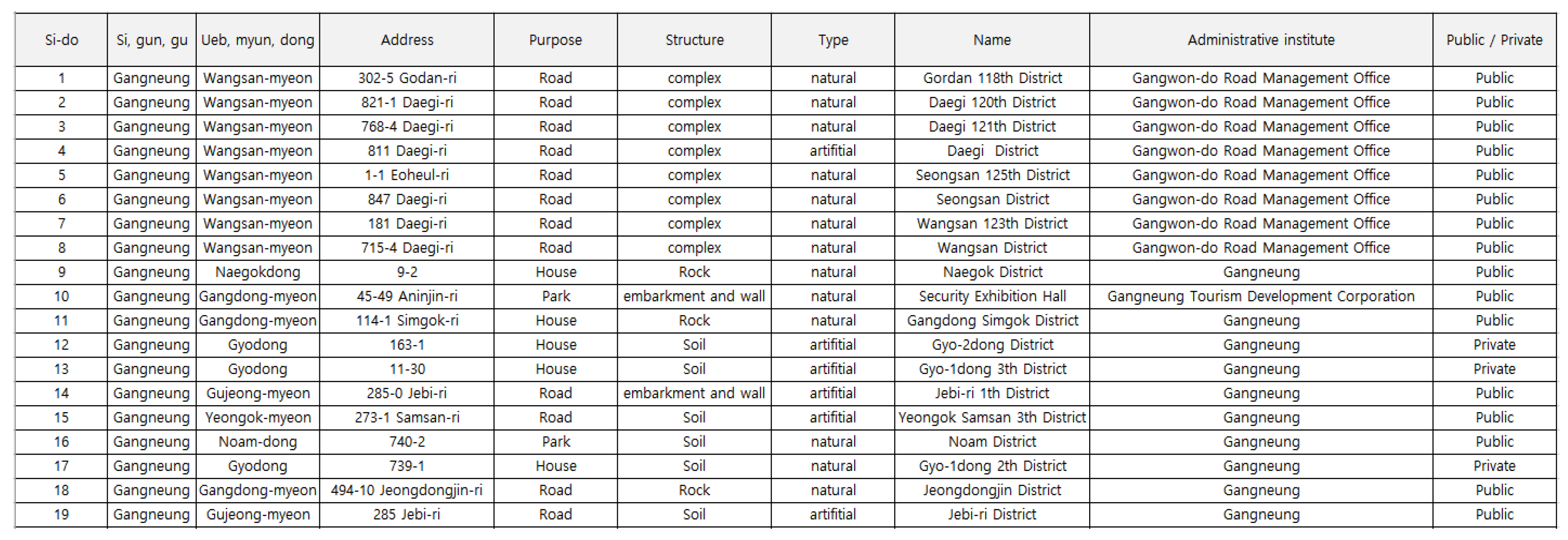
The MOIS carries out evaluations through classifications of natural slopes, artificial slope, retaining walls, and embankments. In this study, the evaluation was conducted by dividing these categories into eight subcategories (natural rock, natural soil, artificial soil, artificial rock, concrete retaining wall, reinforcing earth retaining wall, stonework, and stone mesh), reflecting the classification system in [20]. The management registry of GGSJs contains general addresses. Thus, it is challenging to locate the sites accurately. Therefore, a preliminary survey was first conducted for three weeks in August. The on-site investigation with experts was conducted for ten days, from 27 September to 15 October. Twelve GGSJ experts participated in the on-site evaluation. They were either in charge of developing and modifying the GGSJ evaluation table or of conducting the evaluation on behalf of the GGSJ Association. Table 1 shows the schedules, regions, and types of field evaluation.

Table 1.
Dates and times of site evaluations along with information about the locations, structures, and types of GGSJs.
2.2. Research Process of GGSJ Assessment Principles
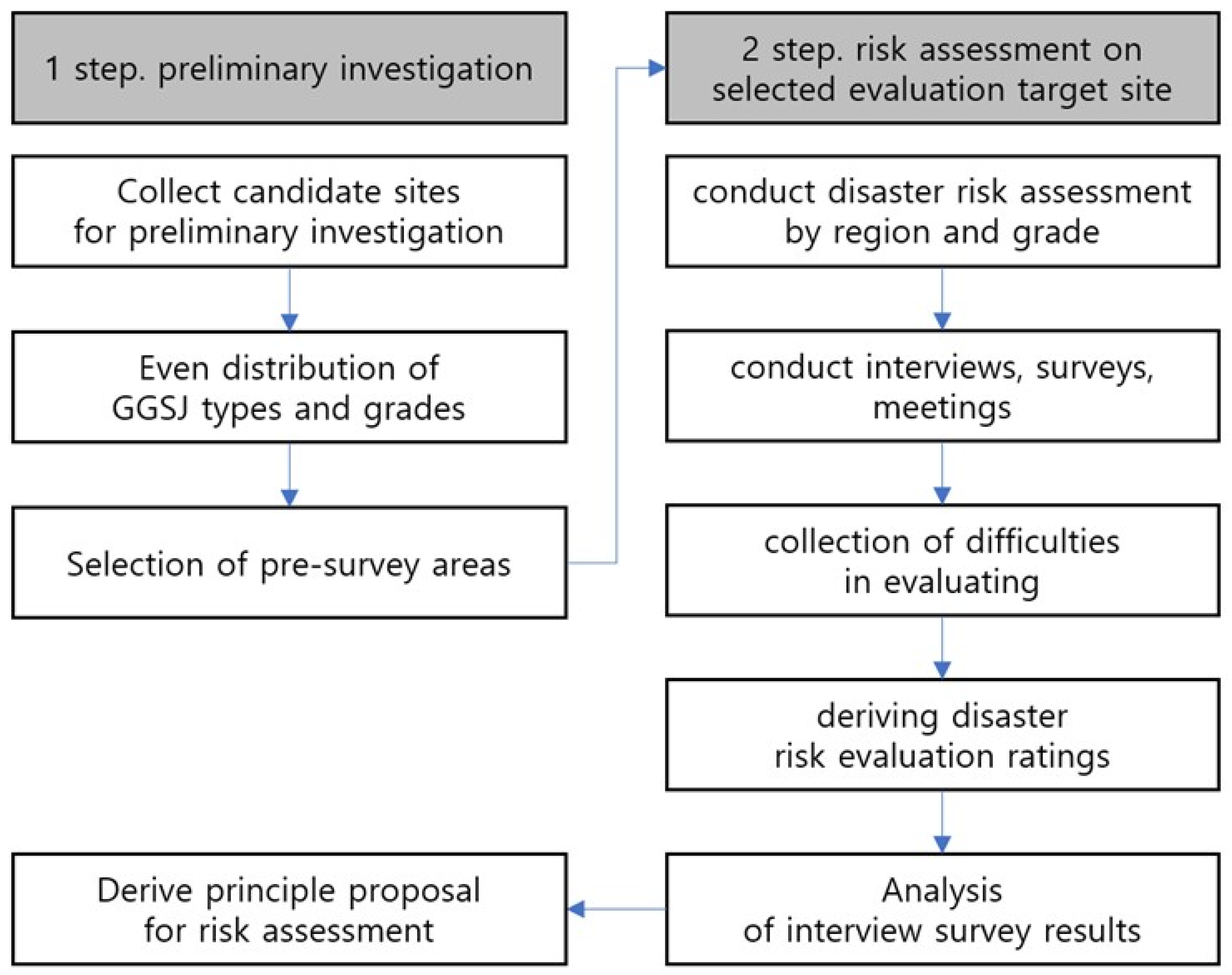
This study aims to investigate complex cases of GGSJ risk evaluation and to present an evaluation method that can be used to respond to them. The study was conducted according to the process outlined in Figure 1, which divided into two parts. In the first step, a preliminary investigation was conducted. To establish the GGSJ evaluation criteria, problems that may arise in evaluation were identified in advance through GGSJ type segmentation, evaluation table self-investigation, and interviews with local government GGSJ managers (evaluation agents). In the second step, risk assessments of selected evaluation target sites were conducted. While evaluating on-site single-slope evaluations by one to five experts, uncertain criteria that led to discrepancies between the evaluation results were identified and the evaluators’ opinions on the solutions to be found were solicited. If there was a disagreement, a valid basis and a method agreed on by most experts were presented. If the opinions were divided, key points to be considered in the GGSJ evaluation were derived from the evaluation methods and the principles of the Ministry of Land, Infrastructure and Transport.
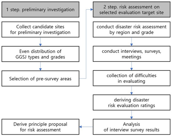
Figure 1.
Flow chart of the research process.
3. Results of the On-Field Evaluations
3.1. Analysis of the On-Field Expert Evaluation Results
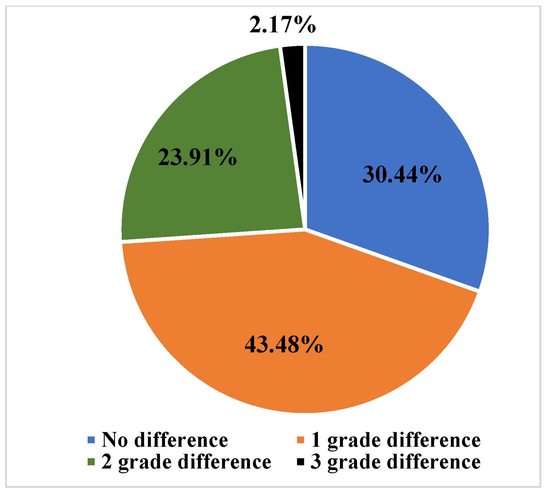
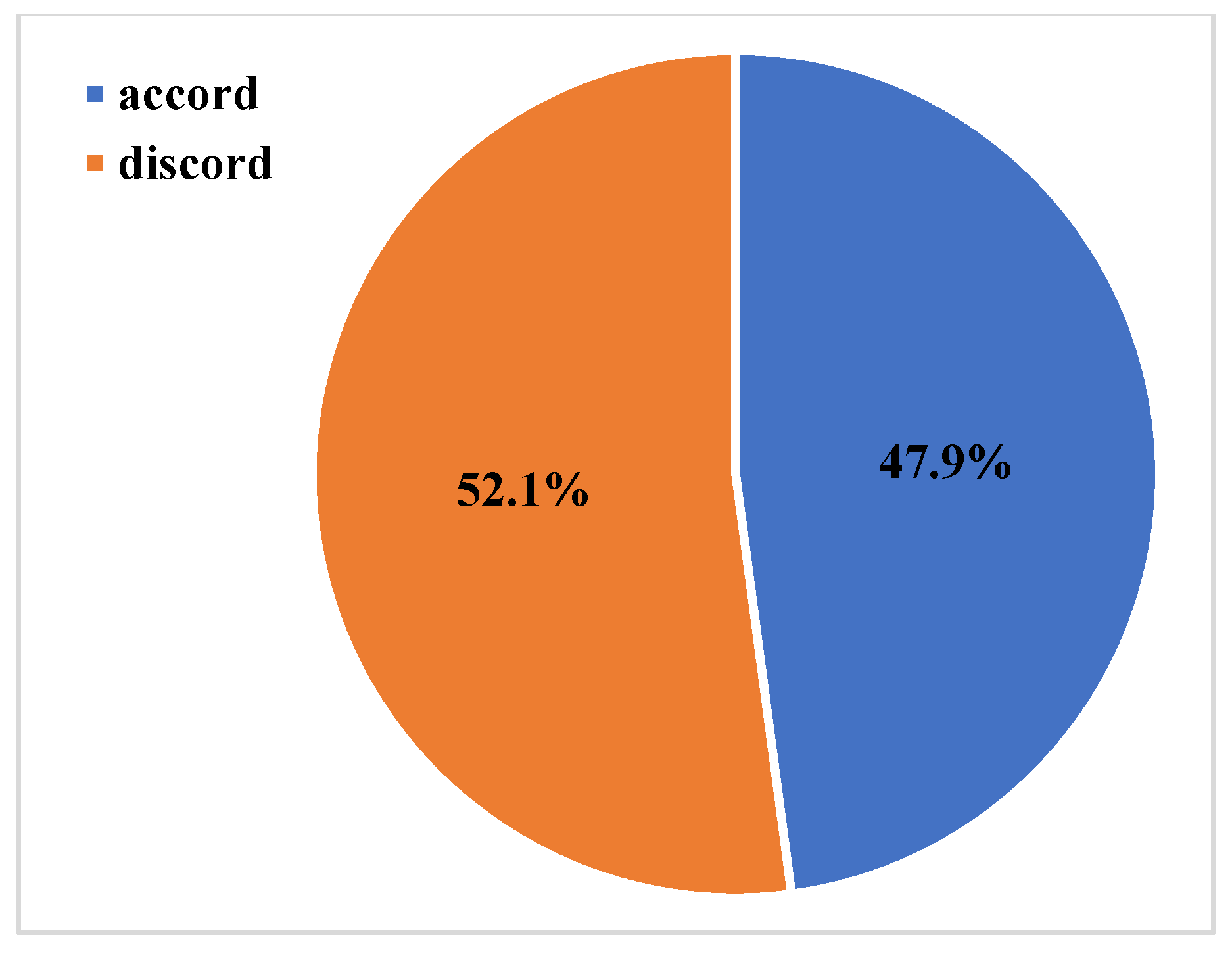
The on-site evaluation was conducted using the GGSJ disaster risk evaluation table to confirm the necessity of establishing the evaluation table. Twelve experts in slope management conducted 33 field evaluations. Table 2 presents the results of the field evaluations. N represents the number of sites surveyed. Data from the MOIS represent the evaluation results for GGSJs currently managed by the ministry. Types (1)–(8) represent natural rock slopes, natural soil slopes, artificial rock slopes, artificial soil slopes, concrete embankments, retaining walls, gabion, and stand embankments, respectively. ‘Complex type’ refers to a slope formed of a combination of types, such as a soil slope and a retaining wall, or an artificial slope and a retaining wall. The evaluation was performed according to the slope characteristics for composite slopes. As there is no evaluation table for complex slopes, evaluations were performed by selecting an evaluation table suitable for the characteristics of the material in question. ‘Expert’ refers to an expert who evaluated a branch, and each slope was evaluated by one to five evaluators. As shown in Table 2, sites 1 to 12 were each evaluated by one expert, site 22 by two experts, and site 33 by five experts. It is difficult to say whether experts evaluated the GGSJs under the MOIS because the results were verified by local government personnel. Therefore, the reliability of the values is questionable. The reliability of the data can be assumed if an expert who has been observing GGSJs for a long time carries out an evaluation according to the evaluation table. The standard values in Table 2 can be confirmed from the values representing the deviations of the evaluation scores of the experts. The evaluation results between experts should be similar. However, Table 2 shows that they do not match. The fact that the evaluation results of the experts differed during this study shows the problem caused by the lack of a standard evaluation method. To identify the cause of this problem, the evaluation results of the experts were confirmed by matching the rates of grades, differences in evaluation grades, and rates of GGSJ types with the evaluation results of existing practitioners. Figure 2 shows the evaluation grade matching rate between experts and practitioners. Only 30.4% of the evaluation grades between practitioners and experts matched. Figure 3 shows the differences between grades among the mismatched grades. The results were 43.48%, 23.91%, and 2.17% for the single-grade, two-grade, and three-grade differences, respectively. The difference reaching two grades proves that there is a large gap in terms of capabilities between experts and practitioners in the current evaluation setting. Figure 4 shows the differences in grades. Ratings between management employees and experts show very little agreement. Evidently, the matching rate for B, C, and D grade was less than 50%. In addition, Figure 5 shows the coincidence rate of slope selection. It is challenging to select and evaluate the type of evaluation table in the case of complex slopes because GGSJs include embankments.
Table 2.
Existing evaluation results of GGSJs from MOIS data and field evaluation results by experts.
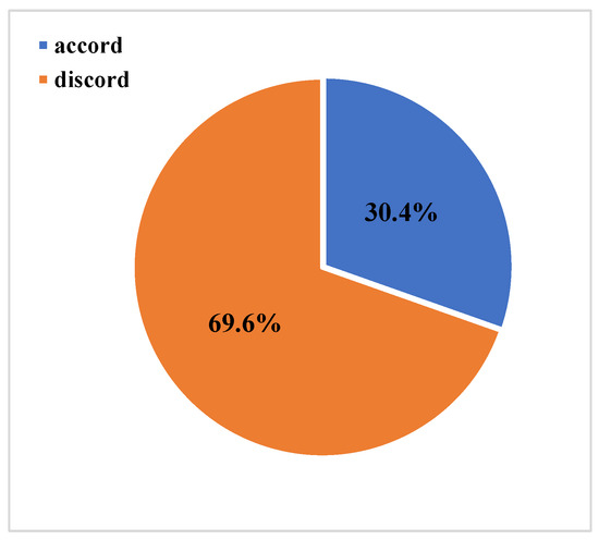
Figure 2.
Rate of consistency between experts and management staff.

Figure 3.
Differences in evaluation grades between experts and management staff.
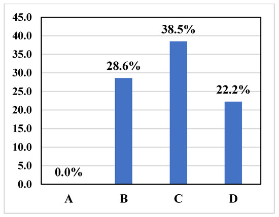
Figure 4.
Rates of agreement between experts and management staff by ratings.

Figure 5.
Slope type selection consistency.
Regarding slope type selection, the agreement rate between practitioners and experts was 47.9%, indicating that less than half of the slopes were being evaluated as the right type of slope. These comparisons show that the lack of a standard evaluation method causes inconsistent results even if the same evaluation table is used. Thus, the evaluation results for GGSJs managed by the MOIS in Korea are rendered questionable. It is therefore necessary to introduce a standard evaluation method to ensure consistency. The GGSJ evaluation grades are numerically stratified in bands of 20 points. For example, a score of more than 60 points would translate to a D grade while a score of 59 points would translate to a C grade, the one-point difference determining whether a slope is designated as a collapse-risk area the maintenance of which is to receive support from the government budget. There is room for the intentional adjustment of evaluation grades through subjective judgment. Therefore, it is necessary to minimize the differences in scores by establishing standard criteria and evaluation methods.
3.2. Deriving the Problems of the Current Evaluation Method through Field Expert Evaluation
This section summarizes the results of the interviews and surveys undertaken to increase the consistency and reliability of evaluation results. Currently registered and managed GGSJ sites were selected for the field evaluation. The local government managed these sites, and their selection, evaluation, and management history were unclear. Unlike in foreign countries where GIS-based platforms manage similar structures, it was challenging to identify the sites’ exact locations, which made it difficult for the experts to conduct their field evaluations. Various problems occurred during the evaluations owing to the absence of a standard evaluation method. The two procedures which vary among experts in GGSJ evaluations are: (1) the determination of the scope of an evaluation; and (2) the selection of the type of assessment table to be used.
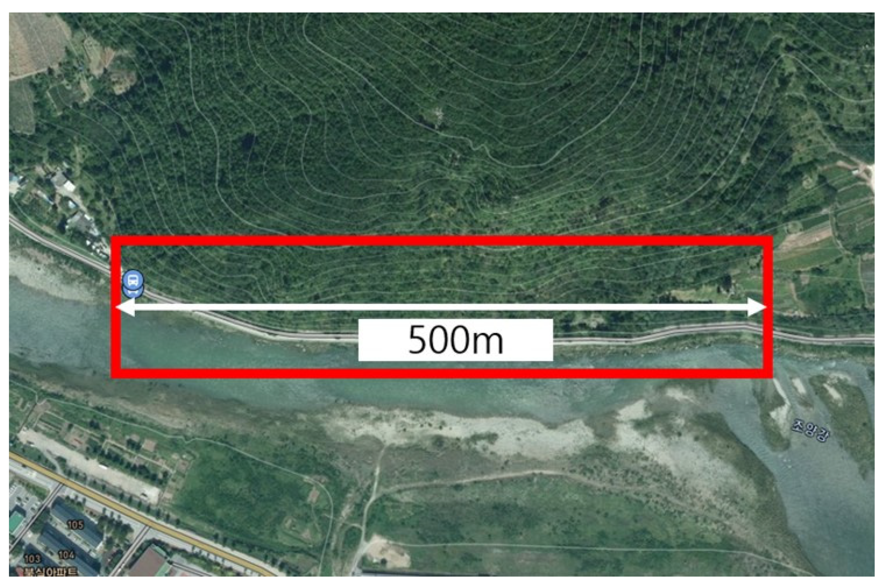
Difficulties arise in determining the scope of an evaluation on a large and on a small scale. It is challenging to select the scope of a GGSJ slope on a large scale. The difficulty lies in the criteria for each index of the evaluation table on a small scale, as the existing guidelines for GGSJs do not include a clear definition of steep slopes for the purposes of classification. According to a recent report by the steep slope association, it is appropriate to divide the evaluation around the valley. However, while some of the 16,071 steep slopes being managed are approximately 10–30 m, there are also some which are more than 100 m. However, they are designated and managed under a single management number. Thus, there is no way to distinguish a GGSJ when evaluating and designating it as a registration management target. Therefore, regardless of the length of the GGSJ, a single risk assessment result is derived. Figure 6 shows a GGSJ spanning 500 m, and the evaluation was performed using a single evaluation table. As every meter of the slope has different material properties, it is difficult to determine the point and range to be evaluated during the field evaluation. When performing the evaluation, the state differs depending on where the evaluator is located and the time of viewing. In general, the evaluator scans the entire slope and performs the evaluation.

Figure 6.
GGSJ area with a length of 500 m.
The evaluations by experts and management staff are dependent on their locations at the time of evaluation. Therefore, even with the same slope, there are differences in evaluation results, as shown in Table 2, and the evaluation scores are inconsistent, as shown in Figure 2. Thus, it is necessary to propose a standard evaluation method for various GGSJs.
The selection of assessment table type is another concern during evaluation. The following question arises when evaluating a complex slope: “Which evaluation table should be used for the GGSJ, and which structure and type should be used as data?” Looking at the evaluation results of the complex slopes among the types in Figure 2, it can be seen that if the assessment table types used in field evaluations differ, the results of steep slope evaluations will differ accordingly. Therefore, since type selection is a significant factor in determining the grade of a slope, different scores and grades are likely to be derived by each evaluator, which is a key point that requires the introduction of a standard. As shown in Figure 7, when a slope is made of one material, the structure may be recorded as rock and evaluated using an artificial assessment table. There is also a problem with evaluating soil and rock simultaneously because there is only one artificial assessment table. Nonetheless, there is no problem with the records of the management ledger. However, as shown in Figure 8, a single type is very rare in GGSJs. As shown in Figure 8, Figure 9 and Figure 10, there are many complex forms in which rock, soil, concrete embankment and gabion exist together in artificial or natural slopes. The GGSJ evaluation table currently consists of only three types (natural slopes, artificial slopes, and embankments). Therefore, the evaluation table to be referred to and the structure and type to be used for data management need to be determined if the slope consists of a diverse composition of materials. This problem may arise when the MOIS manages steep slopes. Figure 11 shows the register format used by the Ministry of Public Administration and Security in 2020, divided into Purpose, Structure, Type, etc. For example, No. 2 Si-do in Figure 11 is complex artificial. It is classified as complex and is depicted in Figure 10. The type is artificial, but it is not known which assessment table was selected for the evaluation. For experts, evaluation can be performed by selecting critical types among structures and types based on experience. However, the reality is that it is difficult for local government officials to perform an evaluation and select a collapse risk area. Evaluations are undertaken in areas for which it is challenging to select an evaluation table, interpret managed data, and determine the GGSJ to be managed because there are no set rules. Therefore, when evaluating GGSJs, selecting an evaluation table and proceeding with the evaluation according to a standard method is essential to create a management system that everyone can understand.
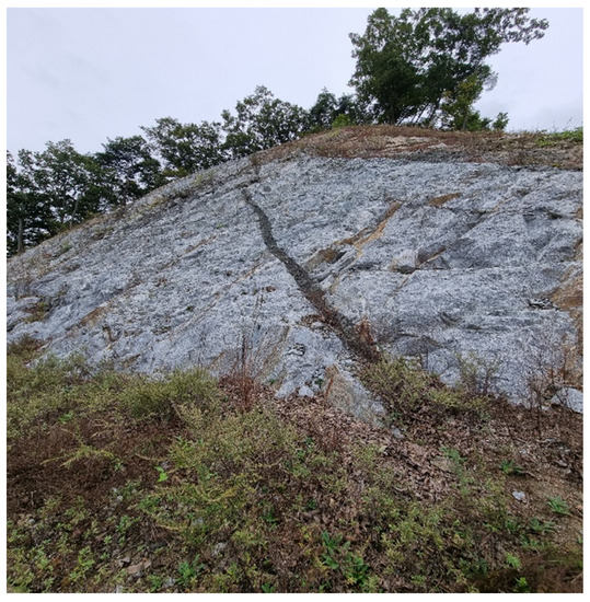
Figure 7.
Single type (artificial rock) GGSJ.

Figure 8.
Complex GGSJ (concrete, gabion, artificial soil).
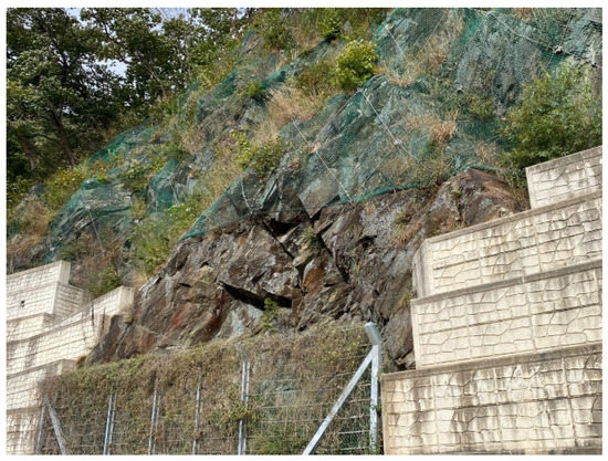
Figure 9.
Complex GGSJ (artificial rock slope, concrete embankment).
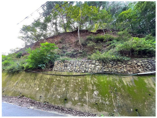
Figure 10.
Complex GGSJ (artificial soil slope, artificial rock slope, gabion, concrete embarkment).
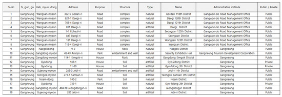
Figure 11.
GGSJ data management format of the MOIS in 2020.
4. Results and Discussion
The purpose of evaluation criteria is to resolve the inefficiency of management through consistency and reliability in field evaluations. We gathered expert opinions through interviews and questionnaires for suggestions relating to (1) decision methods for GGSJ evaluation and (2) GGSJ assessment table type selection. When there was a conflict of opinions about the principles to be adopted, the majority opinion was accepted. Other suggestions were considered by the MOLIT and the Korea Forest Service.
4.1. Length Range in Slope Evaluation
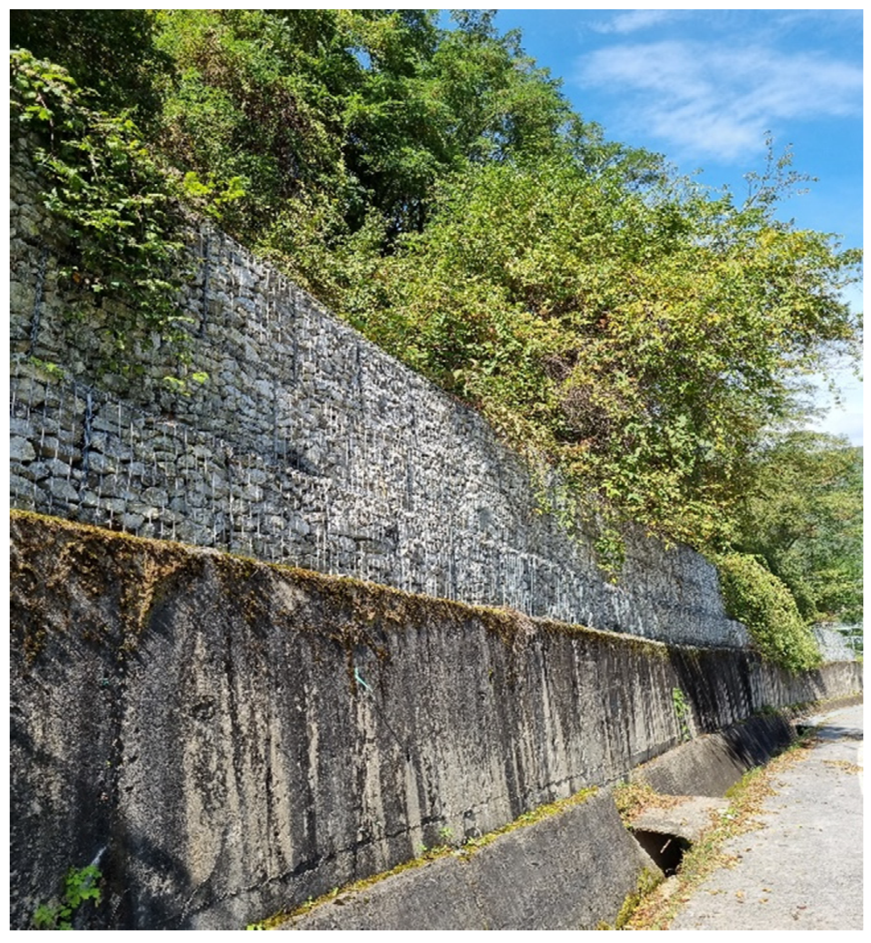
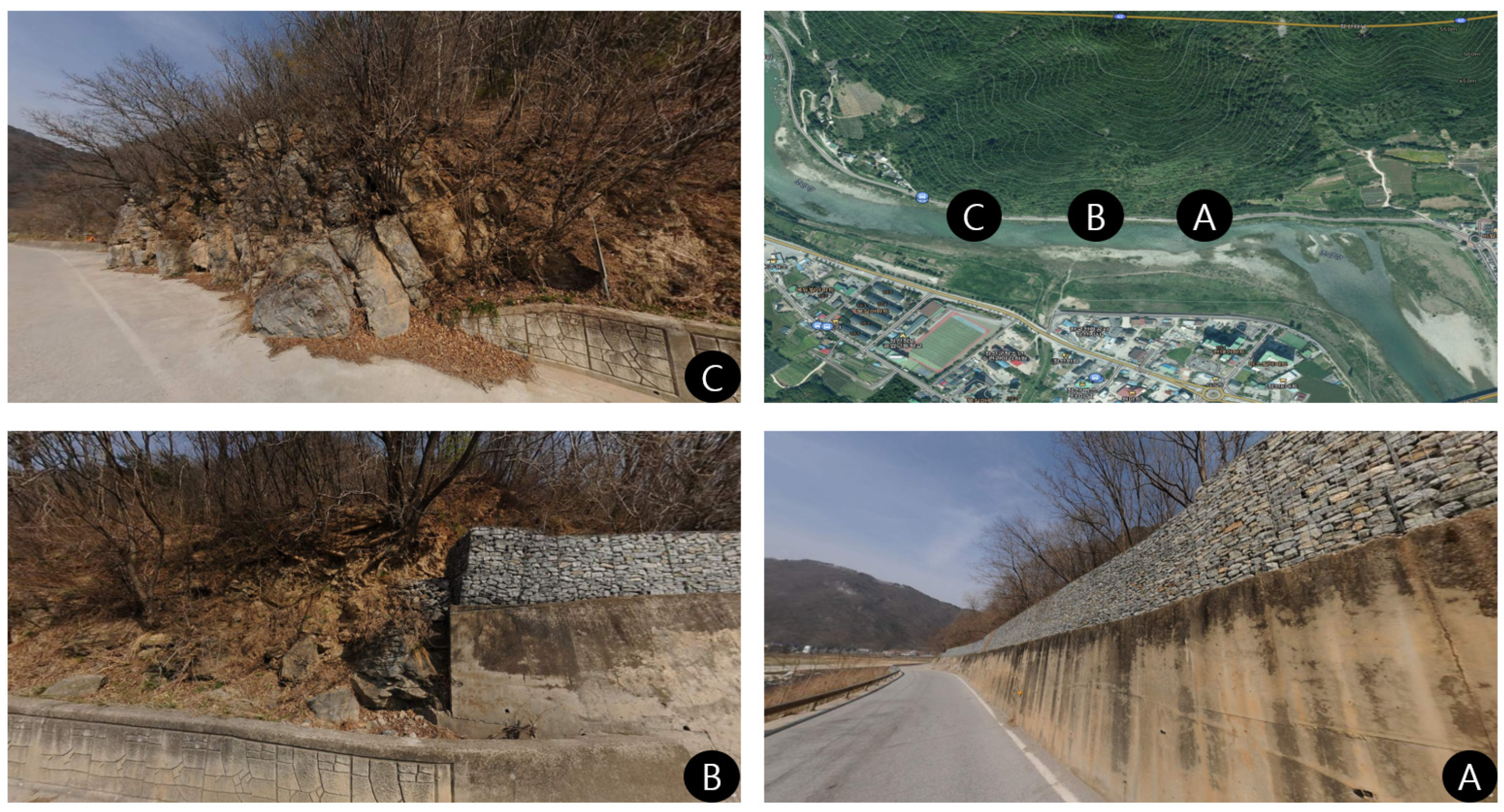
Range classification in slope evaluation needs to be considered because GGSJs of longer lengths are managed as single management areas. Three criteria for dividing an evaluation range were considered in this study based on expert interviews and survey results. First, the evaluation unit (extension standard) used by the Facilities Corporation was determined, with the evaluation being conducted at intervals. Three out of twelve people opted for the method, and the average grade of the entire slope was lowered in the case of a slope spanning 500 m, such as the one shown in Figure 12. There is a problem in that subjectivity is involved in determining the section to be designated. If the average grade is lowered, there is room for exclusion from the designated management list despite the area being at high risk. Opposite cases may also occur despite low risk.

Figure 12.
GGSJ management district with a length of 500 m.
Second, an evaluation target was evaluated by separating it relative to a valley. Four out of twelve people opted for this method, and it was the most appropriate method for distinguishing the range. This is also the method used by the MOIS. However, it is necessary to separate the start and end points for the valley and to evaluate the slope between valleys when evaluating such a site. The subjective judgment of the evaluator determines this. Structures and safety levels differ between valleys. Furthermore, it is easy to select the criteria of the evaluation index if one side is in the same state as that in Figure 12A. However, if the structure or safety grade is different, such as Figure 12B,C, the criteria for evaluation will be disrupted. The right part of the slope (B) has a high stability grade because the gabion and concrete wall improve safety. The left part has the same shape as an unstable slope because there is only a small concrete wall at the bottom. Thus, the safety of slope (B) cannot be ascertained. If the average is used, grade D can be upgraded to grade C. However, disasters are not managed this way. It is best to reduce the damage, regardless of cost. Disaster prevention is possible only when approached with a methodology for preventing maximum losses. Therefore, the most reasonable method to suggest for use as a standard is to select the evaluation criteria based on the most dangerous point of the slope. In addition, the method selected by eight out of twelve experts must be considered. In selecting the extension, condition, and length of a range, without subjective judgment, it is possible to make the selection according to the detailed description for a photo and a guide, thus preventing intentional damage. This can lead to consistent evaluation grade determination for GGSJs nationwide for the effective management of GGSJ DBs. It is necessary to evaluate a critical point to be managed, where maintenance projects can be achieved, so as to prevent disasters.
4.2. Assessment Table Type Selection
The photos and management tables show that natural slopes, artificial slopes, and embankments are often complex. By definition, an artificial slope is a slope produced in a development. Thus, instability is inherent and retaining wall facilities are used to improve safety as a structural measure. Twelve of the thirty-three sites where the field survey was conducted were made up of complex slopes. Although there was an assessment guideline when the experts conducted the evaluation, there was discussion about whether it would be meaningful to evaluate the concrete bedrock with an artificial evaluation table when exposed, as shown in Figure 10. The opinion that the safety of the concrete wall and the safety of the upper rock should be considered as one was dominant. Similarly, with regard to the retaining wall and the stone mantle shown in Figure 9, controversy arose over whether it would be possible to make an accurate evaluation for the retaining wall and embankment with one evaluation table. The slopes in Figure 9 and Figure 10 were evaluated as artificial slopes. The problem here was that it was difficult to check the state of each material.
Therefore, for the slope in Figure 9, the evaluation table, with the consent of 9 out of 12 experts, was evaluated three times by determining the emblement, gabion, and the artificial slope attached to it as the respective materials. There are two advantages to the conduction of an evaluation in this way. First, accurate evaluation results can be obtained because evaluation can be performed for each structure. Therefore, a dangerous structure cannot be ignored because a comprehensive at-risk judgment is not warranted overall. Second, efficiency in GGSJ data management is increased. Suppose all types are recorded as management DB and stored as the representative grade of the area where the low grade is evaluated. In that case, the confusion over selecting and evaluating on the basis of the evaluation table from the viewpoint of the evaluator is reduced, and consistent and reliable data management can be achieved.
5. Conclusions
This study re-evaluated existing managed GGSJs. The goal was to propose an evaluation method to improve the efficiency of management by solving the difficulties in the evaluation process. To achieve the research goal, the following steps were conducted: first, various slopes were selected for a field survey and the survey was performed and evaluated by experts. Second, by analyzing the evaluation results of the experts, difference in grades were confirmed. Third, the necessity of having a standard evaluation method was justified by comparing the evaluation results among experts and confirming the deviation of the evaluation results. Fourth, during the evaluation, the problems encountered were recorded and analyzed in terms of the two aspects of evaluation and management, and solutions were sought. Fifth, the methodology for managing slopes was reviewed, and appropriate solutions were presented through expert interviews and questionnaires. Finally, the results of the study led to a conclusion about the two aspects of results and discretion.
In conclusion, the method for determining the scope of a GGSJ and selecting the evaluation table type should be based on safety and not on subjective judgment. At the time of evaluation, it is necessary to move in the direction of data management by evaluating all types without being concerned about the type of assessment table used. Various kinds of slopes are encountered during evaluations. In the GGSJ evaluation and management system, where experts also generate mixed evaluation results, the difficulties for practitioners are further revealed. Countless issues in small units are selected for each index of the evaluation table. However, without a standard from a large-scale perspective, the evaluation results and managed data will inevitably become meaningless. In addition, the current GGSJ guidelines present an evaluation method and scope for each index; however, many of the current problems deviate from the business guidelines. Therefore, this study focused on maximizing the efficiency, consistency, and reliability of field evaluation and management methods. Additionally, this study focused on GGSJs and cannot be fully generalized for other geospatial distributions. However, it can be generalized to some extent if a similar research procedure to that employed in this study on field evaluation results is carried out.
There are limitations to the field surveys of this study. During the evaluation, as the experts were familiar with the existing evaluation method, there were times when the evaluation was conducted without fully following the work manual. In addition, it may have been difficult to make the assessments because the slopes were not fully exposed during the evaluation owing to bushes. However, this does not affect the field evaluations. Thus, it is considered acceptable to some extent. Supposing that the MOIS introduces legal and administrative changes to the relevant principles and the conduction of on-site evaluations, it will be possible to judge the legitimacy of the results in light of this study by confirming the similarity of the evaluation results of practitioners and experts. In addition, the MOIS will be able to increase the efficiency of its management system. This study analyzed the causes of differences in evaluation results in on-site evaluations and has suggested criteria to reduce such differences. More work is needed for the validation of this study so that it can be applied more widely. While applications will be valid in areas where there are differences in on-site evaluation results, additional research and analysis are required for other areas.
Author Contributions
CRediT authorship contribution statement: J.-J.L.: writing—original draft preparation, data curation, methodology, investigation, conceptualization. W.-S.J.: investigation, data curation, conceptualization. M.-S.S.: conceptualization, methodology, writing—review and editing. S.-G.Y.: methodology, investigation, writing—review and editing. J.-S.K.: methodology, supervision, writing—review and editing. All authors have read and agreed to the published version of the manuscript.
Funding
This research was supported and APC funded by a grant (2019-MOIS33-005) of Lower-level and Core Disaster-Safety 329 Technology Development Program funded by the Ministry of Interior and Safety (MOIS, Korea). This work was supported by the National Research Foundation, Korea (NRF) under Grant [2021R1C1C2010999]. This research was supported by Basic Science Research Program through the National Research Foundation of Korea (NRF) funded by the Ministry of Education (2021R1A6A1A03044326).
Institutional Review Board Statement
Not applicable.
Informed Consent Statement
Not applicable.
Data Availability Statement
Not applicable.
Conflicts of Interest
The authors declare no conflict of interest.
References
- Ministry of the Interior and Safety (MOIS). Prevention of Steep Slope (GGSJ) Disasters Act; Ministry of the Interior and Safety: Sejong, Korea, 2020.
- Ministry of the Interior and Safety (MOIS). Criteria for Evaluating the Hazard of Steep Slopes (GGSJ); Ministry of the Interior and Safety: Sejong, Korea, 2018.
- Maerz, N.H.; Youssef, A.; Fennessey, T.W. New Risk–Consequence Rockfall Hazard Rating System for Missouri Highways Using Digital Image Analysis. Environ. Eng. Geosci. 2005, 11, 229–249. [Google Scholar] [CrossRef]
- Hale, P.A.; Shakoor, A. A Laboratory Investigation of the Effects of Cyclic Heating and Cooling, Wetting and Drying, and Freezing and Thawing on the Compressive Strength of Selected Sandstones. Environ. Eng. Geosci. 2003, 9, 117–130. [Google Scholar] [CrossRef]
- Aydilek, A.H.; Ramanathan, R.S. Slope Failure Investigation Management System; Project Number SP009B4N Final Report; State Highway Administration, University of Maryland: College Park, MD, USA, 2013.
- Geotechnical Engineering Bureau. Rock Slope Rating Procedure; Geotechnical Engineering Bureau: Newyork, NY, USA, 2015.
- Pierson, L.A.; Van Vickle, R. Rockfall Hazard Rating System—Participant’s Manual; FHWA-SA-93-057; United States Federal Highway Administration: Washington, DC, USA, 1993; Volume 1, p. 102.
- Cruden, D.M.; Varnes, D.J. Landslide Types and Processes; Special Report; Transportation Research Board, National Academy of Sciences: Washington, DC, USA, 1996; Chapter 3; Volume 247, pp. 36–75. [Google Scholar]
- Rose, B.T.; Martin, E.C., Jr.; Gutierrez, J.R.; Dymond, M.S. Tennessee Rockfall Management System; Virginia Polytechnic Institute and State University: Blacksburg, VA, USA, 2005. [Google Scholar]
- Mauldon, M.; Drumm, E.C.; Dunne, W.M.; Bateman, V.; Rose, B.; Kim, M. Rockfall Management System for Tennessee; Final Report—Phase I and Phase II; Division of Materials and Tests, Tennessee Department of Transportation: Nashville, TN, USA, 2007.
- Investigator, S. Development of a Highway Rock Cut Rating System (MORFH RS) for Missouri Highways; Department of Transportation: Jefferson City, MI, USA, 2004.
- Huang, S.L.; Darrow, M.M.; Calvin, P. Unstable Slope Management Program; No. FHWA-AK-RD-12-14; Alaska Department of Transportation & Public Facilities, Alaska University Transportation Center: Fairbanks, AK, USA, 2009.
- Muehlbach, P.; Investigator, P. MnDOT Slope Vulnerability Assessments; Minnesota Department of Transportation: Minnesota, MN, USA, 2019.
- Africa, S. The Development of a Strategic Slope Management System for Use in South Africa; CSIR Built Environment Pretoria: Pretoria, South Africa, 1999. [Google Scholar]
- Alam, E. Landslide Hazard Knowledge, Risk Perception and Preparedness in Southeast Bangladesh. Sustainability 2020, 12, 6305. [Google Scholar] [CrossRef]
- Inagaki, K.; Sadohara, S. Slope Management Planning for the Mitigation of Landslide Disaster in Urban Areas. J. Asian Archit. Build. Eng. 2006, 5, 183–190. [Google Scholar] [CrossRef]
- Japan International Cooperation Agency. The Study on Risk Management for Sediment-Related Republic of the Philippines Final Report Guide iii Guide to Table of Contents; Japan International Cooperation Agency: Tokyo, Japan, 2007. [Google Scholar]
- Pierson, L.A. Rockfall Hazard Rat. Transp. Res. Rec. J. Transp. Res. Board 1992, 6–13. Available online: http://onlinepubs.trb.org/Onlinepubs/trr/1992/1343/1343-002.pdf (accessed on 29 June 2022).
- Pierson, L.A. Rockfall Catchment Area Design Guide: Final Report: Metric Edition; No. FHWA-OR-RD-02-04m; Oregon Department of Transportation Research Group: Salem, OR, USA, 2001; Volume 3.
- Lee, J.; Lee, H.; Yun, H.; Kang, C.; Song, M. Improved vulnerability assessment table for retaining walls and embankments from a working—Level perspective in Korea. Sustainability 2021, 13, 1088. [Google Scholar] [CrossRef]


Publisher’s Note: MDPI stays neutral with regard to jurisdictional claims in published maps and institutional affiliations. |
© 2022 by the authors. Licensee MDPI, Basel, Switzerland. This article is an open access article distributed under the terms and conditions of the Creative Commons Attribution (CC BY) license (https://creativecommons.org/licenses/by/4.0/).