1. Introduction
The Taklimakan Desert, located in the Tarim Basin, is the largest desert in China and the second-largest drifting desert in the world [
1]. It has an abundant supply of sand materials from many different sources and comprises many mobile dunes inside [
2] and facing a harsh aeolian sand environment. Under the continuous action of sand-moving wind, the Taklimakan Desert presents a trend of southward expansion [
3]. Qiemo and Ruoqiang, two counties seated on the southeastern fringe of the Taklimakan Desert, have constructed ecological protection projects [
4] based on river systems such as the Qarqan River and the Ruoqiang River, but wind-sand hazards still threaten them. The Hotan–Ruoqiang Railway is the main trunk railway passing through Qiemo and Ruoqiang. The section of the railway running through the two counties is about 261 km in length, of which 58 km is the mobile dune section, 46 km the semi-mobile dune section, and 34 km is the Gobi section. The combined action of rich sand sources and frequent sand-moving winds poses serious threats to the safe service of the railway. In this context, controlling wind-sand hazards is a critical challenge to the construction and maintenance of the railway. Considering that wind is the driving force of wind-sand activities, a systematic study of the characteristics of the local aeolian sand environment is direly needed.
Many studies have been conducted on aeolian sand environments in deserts, Gobi areas, and basins [
5,
6,
7,
8,
9]. It was found that aeolian sand environments and the intensity of sand drift activities vary across different deserts and different regions of the same desert [
10,
11,
12,
13,
14]. There are spatial differences in wind-sand activities. However, the characteristics of the aeolian sand environment in the southeastern fringe of the Taklimakan Desert are rarely systematically explored in the existing studies [
15,
16]. Thus, they cannot offer adequate theoretical support to sand control along railways in the study area. There are obvious spatiotemporal differences in the wind regime characteristics of the study area. Sand drift activities are strongest in the spring and weakest in the winter. Sand drift activities decrease in succession from spring to winter. From Ruoqiang to Qiemo, the effect of the northeasterly wind on railways is gradually weakened, whereas that of the northwesterly wind is gradually enhanced. The landforms passed by railways in the study area are largely alluvial and alluvial deposits with a loose surface, providing abundant sand materials for wind-sand hazards along railways. A majority of railways in the southeastern fringe of the Taklimakan Desert are distributed in dune and Gobi sections. Driven by wind, sand materials move along the dominant direction of the sand drift. Both sand drift rate and dune movement distance vary evidently across different mileage sections [
17]. With the continuous transport and accumulation of dunes, the possibility of derailment is greatly increased, posing a huge potential safety hazard.
In recent years, repeated attempts have been made to prevent and control wind-sand disasters, mainly through setting up obstacles to interfere with airflows, reducing the transport of wind-sand flows, increasing surface roughness, and preventing dunes from moving forward. The efficiency of various wind-sand control measures has been analyzed by numerical simulation [
18,
19,
20,
21]. The main forms of sand hazards along railways in the southeastern fringe of the Taklimakan Desert are wind erosion and sand burial. At present, a series of measures proposed according to the “blocking-fixing” principle (sand blocking and sand fixing) have been taken along the railway, including upright sand fences, reed checkerboards, shelter forest belts, and natural environments [
22,
23,
24]. However, some upright sand fences have toppled under wind-sand action, resulting in weakened sand control effects. As for shelter forest belts, it takes quite a long time to exert their effect fully. The building of a sand control system must be based on a comprehensive consideration of multiple factors. The wind is not only the driving force of dune movement but also a major factor triggering wind erosion. This paper systematically analyzes the characteristics of the aeolian sand environment in the southeastern fringe of the Taklimakan Desert and thoroughly discusses the causes of wind-sand disasters and their impact on railway service in this region. This way, it provides a theoretical basis for improving and optimizing follow-up sand control measures along the railway, presenting great significance for preventing and controlling sand hazards.
2. Overview of the Study Area
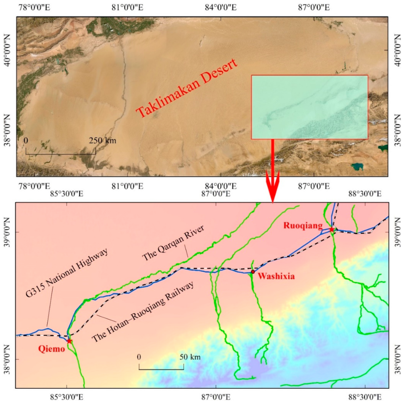
Qiemo and Ruoqiang are located in the southeastern fringe of the Taklimakan Desert. An area covering both counties (37.77°–39.38° N, 84.99°–88.74° E) was selected as the study area (
Figure 1). The study area has a typical continental temperate arid climate, with annual average precipitation of less than 20 mm and annual average evaporation of over 2500 mm. The evaporation is intense, and the diurnal temperature range is high. The annual average temperature, highest temperature, and lowest temperature of the study area are 11.7, 41.3, and −26.4 °C [
4], respectively. The northeasterly wind dominates the study area and has many windy days, especially blowing sand and floating dust days. Fortunately, the Qarqan River and several other water systems in the southeastern fringe of the Taklimakan Desert have nourished the Qiemo Oasis, made outstanding contributions to ecological protection projects in the county, and created favorable conditions for biological sand control along railways. The Hotan–Ruoqiang Railway connecting the two counties passes through the piedmont alluvial-proluvial inclined plain (Ruoqiang DK0+000–Washixia DK80+500) and the alluvial-proluvial inclined plain in the southern margin of the Tarim Basin (Washixia DK80+500–Qiemo DK261+000). The railway includes both passenger and freight traffic, with trains traveling through the desert daily. The aeolian sand environment along the railway is harsh, and the surface is dominated by extremely fine sand, fine sand, and medium sand. The complex topography and characteristics of the sandy environment affect the formation and development of dunes [
25]. Due to abundant sand sources, wind-sand disasters are very serious here, posing grave threats to traffic safety. The angle between the railway trend and sand-moving wind direction is under constant change and first increases and then decreases from Ruoqiang to Qiemo. Due to the variation in the angle, the railway is exposed to sand hazards to varying extents. For sand control, mechanical and biological measures have been combined along the railway in the study area.
3. Data Source and Research Method
The wind regime data used in this paper are hourly wind regime data collected by Qiemo and Ruoqiang Meteorological Stations in 2017–2020. The number of hours with a sand-moving wind velocity of ≥4.5 m/s was counted. The sand-moving wind frequencies of 16 directions were calculated on three-time scales, i.e., annual, seasonal, and monthly. Drift potential (DP) was further calculated from wind velocity by the following equation [
26]:
where DP (VU) denotes DP; V and V
t denote sand-moving wind velocity and critical sand-moving wind velocity, in knots (1 knot ≈ 0.514 m/s); t denotes sand-moving wind time, expressed as the percentage of the number of hours with the sand-moving wind in the total number of hours observed. The critical sand-moving wind velocity of the Taklimakan Desert is 4–5 m/s (4.5 m/s, on average, adopted in this paper) [
27]. According to the definition of Equation (1), five sand-moving wind velocity scales were introduced, namely, 4.5 m/s ≤ V < 7 m/s, 7 m/s ≤ V< 9 m/s, 9 m/s ≤ V< 11 m/s, 11 m/s ≤ V< 13 m/s, and V ≥ 13 m/s. First, the weight factors of these five wind velocity scales were solved, respectively. Then, the DPs of Qiemo and Ruoqiang areas were calculated. Finally, the DPs of 16 directions were used to obtain the resultant drift potential (RDP) and resultant drift direction (RDD). RDP/DP denotes the direction variability index, which is used to characterize the directional variability of sand-moving wind in a region. According to Fyberger’s [
26] division of wind energy environments, DP > 400 VU means a high wind energy environment, 200–400 VU—a medium wind energy environment, and <200 VU—a low wind energy environment. The direction variability index ≤ 0.3 is a small ratio, 0.3–0.8 is a medium ratio, and ≥0.8—a large ratio. A larger direction variability index means a more stable wind direction in the region and vice versa.
4. Results and Analysis
4.1. Landforms and Sand Sources
The landform units passed by the railway include the piedmont alluvial-proluvial inclined plain and the alluvial-proluvial inclined plain in the southern margin of the Tarim Basin. The overall terrain is high in the south and low in the north, with flat and open topography and sparse vegetation. The section from Ruoqiang (DK0+000) to Washixia (DK80+500) has a surface elevation of 890–1000 m and is dominated by Gobi landform (
Figure 2a–c) and distributed with isolated residual dunes locally. Here, the strata are mainly alluvial-proluvial fine sand and fine round gravel soil. The railway mainly passes through the front margin of the alluvial-proluvial inclined plain. By contrast, the section from Washixia (DK80+500) to Qiemo (DK261+000) has a surface elevation of 970–1420 m. The strata here are dominated by silty fine sand. The surface is largely distributed with aeolian sand, which forms dunes locally. The railway mainly passes through the middle of the alluvial-proluvial inclined plain, and oases, wetlands, and aeolian landforms are developed along the railway. Roughly 52.5% of the railway in the study area is exposed to dunes and Gobi areas. The areas affected by sand hazards along the railway were studied by sections according to the mileage pile numbers.
Table 1 provides the starting and ending mileage pile numbers.
Figure 2 shows the typical landforms along the railway in the study area. To be specific, DK0–DK80 are dominated by Gobi areas (a–c) and threaten railway safety mainly in the form of wind-sand flows under the action of strong high-frequency winds. DK113–DK261 are mainly mobile and semi-mobile dunes (d–f) with abundant sand sources. Under the action of sand-moving wind, sand materials are transported and accumulated to the railway, and the sand drift rate here is significantly higher than that in Gobi areas (
Table 1). Mobile and semi-mobile dunes constitute the primary sand source of sand hazards in DK113–DK261.
4.2. Characteristics of Sand-Moving Wind
Sand-moving wind is the driving force of sand particle movement. Sand-moving wind velocity refers to the critical wind velocity at which sand particles begin to move after breaking through surface friction and gravity constraints. In this sense, research on sand-moving wind offers an important basis for setting up sand-control projects.
4.2.1. Characteristics of Annual Sand-Moving Wind
Data analysis indicates that the annual average sand-moving wind velocities of Qiemo and Ruoqiang were 5.99 and 6.11 m/s, respectively, and that the annual sand-moving wind frequencies of Qiemo and Ruoqiang were 20.09% and 7.63%, respectively.
Figure 3 shows that the prevailing direction and frequency of annual sand-moving wind in Qiemo were NE and 10.38%, respectively, and that those of annual sand-moving in Ruoqiang were ENE/NE and 3.52/2.33%, respectively.
4.2.2. Characteristics of Seasonal Sand-Moving Wind
Figure 4a shows the seasonal sand-moving wind frequencies of Qiemo and Ruoqiang. Sand-moving wind frequency peaked in the spring, followed in succession by the summer and the autumn, reaching its lowest value in the winter. The average sand-moving wind velocities of Qiemo and Ruoqiang peaked in the spring (6.15 and 6.34 m/s), followed in succession by the summer and the autumn, and reached their lowest values (5.52 and 5.63 m/s) in the winter (
Figure 4b). As shown in
Figure 5a,b, the prevailing direction of the seasonal sand-moving wind was consistent with that of annual sand-moving wind in both Qiemo (NE) and Ruoqiang (ENE). The sand-moving wind frequencies of the four seasons presented consistent variation trends in 16 directions. The prevailing directions of sand-moving wind were concentrated in NE and ENE, and sand-moving wind frequencies were extremely weak in SE and NW. The prevailing direction of the sand-moving wind in the spring in Qiemo was NE. Sand-moving wind frequency in NE accounted for 61.3% of the sand-moving wind frequency in the spring in Qiemo. The variation trends in various directions in the autumn and the winter were consistent with those in the spring. In the summer, sand-moving wind frequency presented a blunt bimodal pattern, while the prevailing directions of sand-moving wind were NNE and NE, accounting for 23.8 and 35.5% of the sand-moving wind frequency in the summer in Qiemo, respectively. In the contrary directions SW and WSW, sand-moving wind frequency increased abruptly, and sand-moving wind was disorderly in the summer, accompanied by a complex wind regime. In comparison, in Ruoqiang, sand-moving wind in the spring was jointly dominated by NE and ENE, which accounted for 38.7 and 49.5% of the sand-moving wind frequency in the spring in Ruoqiang, respectively. The variation trends in various directions in the autumn and the winter were consistent with those in the spring. In the summer, the prevailing directions of sand-moving wind in Ruoqiang were NNE and SW, which accounted for 33 and 24.7% of the sand-moving wind frequency in the summer in Ruoqiang, respectively. The sand-moving wind frequency in the summer in Ruoqiang presented a more significant blunt bimodal pattern, suggesting that sand-moving wind was more disorderly in the summer in Ruoqiang.
4.2.3. Characteristics of Monthly Sand-Moving Wind
There were differences among various months in the variation characteristics of sand-moving wind frequency and velocity. As shown in
Figure 6a, the variation trends of sand-moving wind frequency in Qiemo and Ruoqiang were consistent. Specifically, sand-moving wind frequency gradually increased from January to April, peaked in April and May, and presented a declining trend from April and May to December. For the two counties, the extreme values of monthly average sand-moving wind velocity and monthly sand-moving wind frequency occurred in the same periods. The monthly average sand-moving wind velocity of Qiemo fell within the range of 5.33–6.28 m/s and reached its maximum and minimum values in May and December, respectively. The monthly average sand-moving wind velocity of Ruoqiang fluctuated between 5.35 and 6.47 m/s and reached its maximum and minimum values in April and December, respectively (
Figure 6b).
Figure 6c,d indicates that the variation trends of monthly sand-moving wind directions were consistent with annual and seasonal sand-moving wind directions in the two counties. The prevailing direction of the monthly sand-moving wind in Qiemo was NE, and the prevailing directions of monthly sand-moving wind in Ruoqiang were ENE and NE. Prevailing directions accounted for large proportions of monthly sand-moving wind frequency in March, April, and May. Specifically, in Qiemo, NE accounted for 69.02, 63.72, and 52.55% of monthly sand-moving wind frequency in March, April, and May, respectively. In Ruoqiang, ENE and NE accounted for 90.63, 89.73, and 84.78% of monthly sand-moving wind frequency in March, April, and May, respectively. Sand-moving wind direction presented a blunt bimodal pattern in June in Qiemo and Ruoqiang. June is the beginning month of the summer. The variation trend of its sand-moving wind frequency in various directions was consistent with the overall sand-moving wind frequency in the summer. Among various summer months, June accounted for the largest proportion of sand-moving wind frequency and had a variable sand-moving wind direction and a harsh aeolian sand environment.
4.3. Characteristics of DP
4.3.1. Characteristics of Annual DP
According to
Figure 7, the annual DPs of Qiemo and Ruoqiang were 124.21 and 66.18 VU, respectively. The RDP, RDD, and RDP/DP of Qiemo were 73.81 VU, 222.34°, and 0.594, respectively, and those of Ruoqiang were 40.73 VU, 241.79°, and 0.610, respectively. Both counties had medium directional variability. The annual DP of Qiemo presented a trend of dominance by a single wind direction, with a prevailing direction of NE, 62.82 VU. The prevailing direction of the annual DP of Ruoqiang was ENE, 34.85 VU. According to the division of wind energy environments, both counties had a low-wind-energy environment. The intensity of sand drift activities in Qiemo was much higher than that in Ruoqiang. Medium direction variability suggests that the two counties have relatively stable sand-moving wind directions on the annual scale, which are mainly concentrated in NE and ENE.
4.3.2. Characteristics of Seasonal DP
Figure 8 shows that the variation characteristics of seasonal DP were consistent with the variation characteristics of seasonal sand-moving wind frequency in Qiemo and Ruoqiang. Qiemo and Ruoqiang had the largest DPs (54.90 and 37.46 VU) in the spring, with RDPs of 42.27 and 30.20 VU and RDDs of 226.30° (SW) and 238.84° (WSW), respectively. Their RDP/DPs were 0.770 (medium ratio) and 0.806 (large ratio), respectively. The above results indicate that the wind directions of the two counties in the spring are fixed and not liable to variation. However, spring is also the season most susceptible to wind-sand disasters, mainly because of the largest DP in this season. In the summer, the DPs of Qiemo and Ruoqiang were 46.91 and 16.30 VU, respectively. Their RDPs were 15.49 and 2.04 VU, respectively. Their RDP/DPs were 0.330 and 0.125 only, respectively. The RDP/DP of Qiemo in the summer was extremely close to a small ratio, while that of Ruoqiang was already a small ratio, indicating that wind directions are variable in the summer. As shown in
Figure 8, the DP in the direction opposite to the prevailing direction accounted for a considerable proportion in the summer, resulting in a smaller RDP and a greater effect on RDD in this season. The RDD of Qiemo in the summer was 213.22° (SSW), and that of Ruoqiang was 259.77° (W). These results are different from the overall manifestations. Although the summer had a lower intensity of sand drift activities than the spring, it is the season with the most complex wind regime among the four seasons. In the autumn, the DPs of Qiemo and Ruoqiang were 19.98 and 9.03 VU, respectively. Their RDPs were 15.45 and 6.64 VU, respectively. Their RDP/DPs were 0.774 and 0.735 only, respectively. Compared with the other three seasons, autumn has relatively stable wind directions. The RDDs of Qiemo and Ruoqiang in the autumn were 220.29° (SW) and 245.60° (WSW), respectively. These results are in good agreement with their respective annual RDDs. Overall, autumn has a low intensity of sand drift activities, a relatively stable wind regime, and simple wind directions. Qiemo and Ruoqiang had the smallest DPs (8.30 and 3.39 VU) in the winter, with RDPs of 6.78 and 2.00 VU and RDDs of 225.18° (SW) and 237.31° (WSW), respectively. Their RDP/DPs were 0.816 and 0.589 (medium ratio), respectively. On the whole, there are relatively stable wind directions and infrequent sand-drift activities in the winter.
The DPs of Qiemo and Ruoqiang decrease in succession from the spring to the winter, accompanied by a gradual decline in the intensity of sand drift activities. The prevailing directions of seasonal DP and annual DP are consistent. DP activities are intense in the spring and the summer. Wind directions are concentrated in the spring, making it convenient for the transport and accumulation of sand to the railway and resulting in traffic interruption. The complex wind regime makes it difficult to maintain stable wind directions in the summer. RDD is manifested as the combined action of several opposite directions, and sand drift activities in multiple directions pose great difficulties to sand control.
4.3.3. Characteristics of Monthly DP
The monthly DP and RDP variation trends were consistent with monthly sand-moving wind frequency (
Figure 9). Overall, the DPs of Qiemo and Ruoqiang showed parabolic fluctuations on the monthly scale. The DP of Qiemo peaks (22.4 VU) in May, and its RDD and RDP/DP were 223.93° (SW) and 0.608 (medium ratio). In June, its RDP/DP ratio was extremely low (merely 0.094), suggesting that sand-moving wind is highly variable in this region; its RDP and RDD were 2.10 VU and 191.46°, respectively, which are much different from the overall manifestations. The monthly DP of Ruoqiang peaked (16.06 VU) in May, after which it first dropped considerably, then increased slightly in October, and finally declined gradually. According to
Figure 9, the monthly fluctuation amplitude of RDP/DP in Ruoqiang was higher than that in Qiemo. The RDP/DPs of the two counties dropped drastically in June and December, suggesting that the sand-moving wind direction is disorderly in both months. On the whole, Qiemo has a more stable sand-moving wind direction, which means a greater threat from sand hazards on the upwind side of the railway. By contrast, in Ruoqiang, both sides of the railway are threatened by sand hazards under the action of constantly changing sand-moving wind.
5. Discussion on Wind-Sand Hazards and Sand Control along the Railway
5.1. Wind-Sand Hazards and Their Causes along the Railway
Because of landforms, an aeolian sand environment, and the angle between the railway and sand-driving wind, the railway is exposed to different degrees and forms of wind-sand hazards. Sand-driving wind and sand sources are necessary conditions for wind-sand activities, greatly affecting the shape and movement of dunes. The annual average sand-moving wind velocity of the study area is 5.99–6.11 m/s, and its prevailing directions are NE and ENE. The magnitude and direction of DP are consistent with sand-moving wind frequency on multiple time scales and are greatly affected by sand-moving wind frequency [
9]. Its annual RDDs are SW and WSW, meaning that sand particles are transported along the NE–SW direction, consistent with Dong’s [
28] analysis of dune movement in different areas of the Taklimakan Desert. The intensity of sand drift activities presents spatiotemporal differences. Temporally, the spring and the summer account for large proportions of sand-moving wind frequency and have intense sand-drift activities, while the autumn and the winter have low wind energies. Spatially, the sand-moving wind velocity and intensity of sand drift activities of Qiemo are much higher than those of Ruoqiang.
Ruoqiang is mainly distributed with flat sandy land and shrub-coppice dunes. Barchan dunes and chains gradually appear from Ruoqiang to Qiemo. The movement direction of barchan dunes is consistent with RDD. Under the wind action, wind-sand flows strongly impact the railway and seriously affect driving safety. Sand-driving wind regime and DP show seasonal variation characteristics. Wind-sand activities are most frequent in the spring, and the intense sand-drift activities and stable sand-drift directions in the spring bring sufficient sand sources along the railway. Meanwhile, the passage of the railway disturbs local wind balance and destroys dune stability, for which the railway is inevitably exposed to sand hazards.
The railway runs along the NE–SW direction, and the angle between the prevailing direction of the sand-moving wind and the dominant direction of sand drift is small (
Figure 10). The railway trend directions of Ruoqiang and Qiemo are about 247 and 230°, respectively. The RDD of Qiemo was smaller than its railway trend angle in each season (
Figure 8). Sand drift activities mainly occur on one side of the railway, so sand control should be strengthened on the upwind side. In the summer, Ruoqiang has a highly changeable wind direction, and its RDD was 259.77, greater than the railway trend. In the spring, the autumn, and the winter, its RDD was smaller than the railway trend. That is, sand drift activities occur on both sides of the railway in Ruoqiang, and sand control on the downwind wide cannot be ignored.
5.2. Sand Control System
5.2.1. Mechanical Sand Control System
Studies have shown that single sand control measures fail and become ineffective after a short while in aeolian sand environments [
29], causing railways to be exposed to wind-sand hazards again. On that account, a sand control mode combining mechanical and biological measures has been adopted along the railway in the study area according to the “blocking-fixing” principle to achieve a satisfactory sand control effect. Mechanical sand control measures mainly include upright sand fences and reed checkerboards. Upright sand fences, erected on the outermost side of the mechanical sand control system, realize wind prevention and sand resistance by reducing incoming wind velocity and depositing sand particles. The wind-sand flows intercepted by upright sand fences enter reed checkerboards, which play a sand-fixing role by increasing surface roughness (
Figure 11a). Aeolian sand environments have spatiotemporal variation characteristics, so the setting of the sand control system should fully consider the variations in the angle between railway and sand drift direction and in sand-driving wind direction. The railway trend in the study area is almost parallel to the sand drift direction, so sand-guiding measures should be stressed. The upright sand fences on the outermost side are arranged in a folded pattern (
Figure 11b), as these can achieve a more significant sand accumulation effect than straight sand fences can under this pattern. Wind directions in the summer are disorderly in the study area, especially the Ruoqiang area. The angle between the sand-drift direction and railway is large in the summer, so straight upright sand fences were adopted in some sections (
Figure 11c).
Sand control measures should be adapted to local conditions. Sand control width should be set reasonably to reduce capital and human resource inputs. Spatial variations in aeolian sand environments require that sand control measures be adjusted accordingly. Concerning areas facing serious wind-sand hazards, the number of rows of upright sand fences and the width of sand-fixing checkerboards on both sides of the railway should be adjusted for wind-sand hazards.
Figure 12a shows the passage of the railway through a mobile dune area. The upwind side is erected with three rows of upright sand fences, which are 240 m away from the railway at the closest. The downwind side is erected with two rows of upright sand fences, which are 170 m away from the railway at the closest. Affected by the aeolian sand environment, the status of upright sand fences on the upwind side is inferior to that on the downwind side.
Figure 12a,b shows that the distances between the upright sand fences on the upwind and downwind sides and railway are reduced by 30 m, and one row of upright sand fences is reduced on each side of the railway. As shown in
Figure 12c,d, each side of the railway is erected with one row of upright sand fences. Differing from
Figure 12b, both
Figure 12c,d show reduced distances between the upwind sand fences and railways and increased distances between the downwind sand fences and railways. Additionally, in
Figure 12d, the downwind side is arranged with lateral guidance devices to lead wind-sand flows through railway culverts, thus weakening the direct erosion of railway subgrade by the wind-sand flows.
5.2.2. Biological Sand Control Measures
Studies have revealed that the morphology of dunes varies greatly from one side of the river to the other. The shrubs on both sides of the river intercept some sand particles. Their growth also modifies the near-surface wind regime, reduces wind velocity, and increases the threshold of sand-driving wind velocity, playing an important role in wind prevention and sand fixation. The Qarqan River section (DK149–DK161) parallel to the railway has a high vegetation coverage rate. When wind-sand flows are slowed and intercepted by vegetation and the river, the sand drift rates are significantly reduced, indicating that vegetation provides effective protection for the railway. Therefore, vegetation coverage along the railway can be gradually improved by fully utilizing the water systems flowing through the study area. Biological and mechanical sand control measures can be combined to reduce wind-sand hazards. The perennial rivers flowing through the study area include the Ruoqiang River, the Washixia River, and the Qarqan River. Originated mainly in ice and snow melting water, these rivers show great differences in flow during wet and dry seasons. Their flood peaks usually occur from June to August, i.e., the hottest period. The winter and the spring are dry seasons. In the flood peak period, the downstream inclined plain in the Gobi area is threatened by floods. The underground water level is highly variable due to the topography or landforms. The study area has a harsh natural environment, so the species selected for biological sand control must be able to withstand drought, cold, high temperature, and wind erosion. Based on the natural environment and wild plant resource distribution along the railway and the experience from built-up projects, this paper proposes three ideal sand-fixing shrub species, i.e., Calligonum mongolicum, Tamarix chinensis, and Haloxylon ammodendron.
It takes a relatively long period for biological sand control measures to exert their effect fully. In an environment facing wind erosion and sand burial, sand fences are erected by rows and columns along the outer edges of forest belts to protect plant seedlings and guarantee their survival rate. Meanwhile, it is also necessary to ensure a sufficient water supply. In deserts, drip irrigation is often adopted to reduce evaporation and supply water directly to plant roots (
Figure 13). The factors considered in setting the width of biological sand control layout are the degree of wind-sand hazards along the railway and the angle between the railway trend and sand drift direction. In the principle of “adapting sand control measures to the severity of wind-sand hazards”, the width of the biological sand control layout on the upwind side is greater than that on the downwind side. In case of a larger angle between railway trend and sand drift direction, the shelter forest belt will also be wider.
6. Conclusions
Wind-sand hazards are the primary problem to be solved during railway operations. This study systematically analyzes the wind energy environment and sand transport activities along the railway and discusses the measures for wind and sand control in combination with the railroad alignment. The control of wind-sand should integrate multiple factors to achieve targeted, site-specific.
The average sand-moving wind velocities of Qiemo and Ruoqiang, located in the southeastern fringe of the Taklimakan Desert, are 5.99 and 6.11 m/s, respectively. The sand-moving wind frequency of Qiemo is higher than that of Ruoqiang, and their annual sand-moving wind frequencies are 20.09% and 7.63%, respectively. The sand-moving wind frequencies of the two counties show obvious seasonal variations and are relatively synchronous. The spring has the highest sand-moving wind frequency, followed in succession by the summer, the autumn, and the winter.
The DPs of Qiemo and Ruoqiang are 124.21 and 66.18 VU, respectively, so they are both low-wind-energy environments. Their RDP/DPs are 0.594 and 0.610, respectively, which are medium ratios. Their RDDs are 222.34° and 241.79°, respectively, and sand particles are transported from NE to SW. The variation of DP is consistent with that of sand-moving wind frequency on various time scales. Besides stable wind directions, the spring also has the largest DP, followed in succession by the summer, the autumn, and the winter. The aeolian sand environment is harsh in the summer, and the wind directions are most variable.
The aeolian sand environment in the southeastern fringe of the Taklimakan Desert shows obvious spatiotemporal variations. According to the “blocking-fixing” principle, a sand control system combining mechanical (upright sand fences and reed checkerboards) and biological (Planting sand-fixing shrubs) measures has been adopted along the railway in the study area. The widths of upright sand fences and sand-fixing checkerboards in mechanical sand control measures are also adjusted with a view of the spatial variations in the aeolian sand environment to realize efficient and effective sand control.
Considering that single sand control measures are incapable of fully controlling sand hazards, an integrated sand control system should be developed based on a comprehensive analysis of sand drift rate, railway trend, the aeolian sand environment, and other related factors.
Author Contributions
Conceptualization, B.M. and J.C.; methodology, J.C. and L.Q.; software, B.M.; validation, L.G., L.Q. and Y.A.; formal analysis, B.D. and L.D.; writing—original draft preparation, B.M. and B.D; writing—review and editing, J.C. and L.G. All authors have read and agreed to the published version of the manuscript.
Funding
This research was funded by the Major Program of Science and Technology of Xinjiang Production and Construction Corps (2020AA002), the National Natural Science Foundation of China (52168065), and the Program of Young and Middle-Aged Science and Technology Innovation Leading Talents of Xinjiang Production and Construction Corps (2019CB023).
Institutional Review Board Statement
Not applicable.
Informed Consent Statement
Not applicable.
Data Availability Statement
Not applicable.
Acknowledgments
The authors would like to thank Bosong Ding for his valuable advice on this research. The authors also thank the reviewers and editors who helped to improve the quality of this paper.
Conflicts of Interest
The authors declare no conflict of interests.
References
- Li, C.; Wang, Y.; Lei, J.; Xu, X.; Wang, S.; Fan, J.; Fan, S. Damage by wind-blown sand and its control measures along the Taklimakan Desert Highway in China. J. Arid. Land 2021, 13, 98–106. [Google Scholar] [CrossRef]
- Dong, Z.B.; Chen, G.T.; He, X.D.; Han, Z.W.; Wang, X.M. Controlling blown sand along the highway crossing the Taklimakan Desert. J. Arid. Environ. 2004, 57, 329–344. [Google Scholar] [CrossRef]
- Sun, X.Y. Expansing Trend Analysis of Taklimakan Desert Base on the Calculation of Circulation of Sand Drift Potential; Sichuan Normal University: Sichuan, China, 2019. [Google Scholar]
- Yang, X.H.; Fan, J.L.; Xu, X.W.; Huang, Y.; Ma, J.Y.; Xi, X. Research on Microclimate Effects of Shelterbelt Project in the Oasis Desert Ecotone of Qiemo. Res. Soil Water Conserv. 2016, 23, 183–187. [Google Scholar] [CrossRef]
- Liu, Z.; Dong, Z.; Zhang, Z.; Cui, X.; Xiao, N. Spatial and temporal variation of the near-surface wind regimes in the Taklimakan Desert, Northwest China. Theor. Appl. Climatol. 2019, 138, 433–447. [Google Scholar] [CrossRef]
- Pi, H.; Sharratt, B.; Lei, J. Windblown sediment transport and loss in a desert-oasis ecotone in the Tarim Basin. Sci. Rep. 2017, 7, 7723. [Google Scholar] [CrossRef]
- Wang, X.M.; Dong, Z.B.; Yan, P.; Zhang, J.W.; Qian, G.Q. Wind energy environments and dunefield activity in the Chinese deserts. Geomorphology 2005, 65, 33–48. [Google Scholar] [CrossRef]
- Yang, Y.; Qu, Z.; Shi, P.; Liu, L.; Zhang, G.; Tang, Y.; Hu, X.; Lv, Y.; Xiong, Y.; Wang, J.; et al. Wind regime and sand transport in the corridor between the Badain Jaran and Tengger deserts, central Alxa Plateau, China. Aeolian Res. 2014, 12, 143–156. [Google Scholar] [CrossRef]
- Miao, H.L.; Wang, J.; Zhang, R.Q.; Li, J.R.; Gao, T.M. Characteristics of wind regime and drift potential of the desert steppe in northern slope of Yinshan Mountains, Inner Mongolia. J. Arid. Land Resour. Environ. 2022, 36, 102–110. [Google Scholar] [CrossRef]
- Dong, Z.; Zhang, Z.; Lv, P.; Qian, G.; Luo, W. Analysis of the wind regime in context of dune geomorphology for the Kumtagh Desert, Northwest China. Z. Fur Geomorphol. 2012, 56, 459–475. [Google Scholar] [CrossRef]
- Meng, N.; Wang, N.A.; Zhao, L.; Niu, Z.; Sun, J. Wind regimes and associated sand dune types in the hinterland of the Badain Jaran Desert, China. J. Arid. Land 2022, 14, 473–489. [Google Scholar] [CrossRef]
- Yang, H.; Cao, J.; Hou, X. Characteristics of Aeolian Dune, Wind Regime and Sand Transport in Hobq Desert, China. Appl. Sci.-Basel 2019, 9, 5543. [Google Scholar] [CrossRef]
- Zhang, K.; Qu, J.; An, Z. Characteristics of wind-blown sand and near-surface wind regime in the Tengger Desert, China. Aeolian Res. 2012, 6, 83–88. [Google Scholar] [CrossRef]
- Zu, R.; Xue, X.; Qiang, M.; Yang, B.; Qu, J.; Zhang, K. Characteristics of near-surface wind regimes in the Taklimakan Desert, China. Geomorphology 2008, 96, 39–47. [Google Scholar] [CrossRef]
- Chen, S.S.; Ma, S.H.; Xue, J.; Luo, J.; Wu, X.G.; Cheng, H. A study on the meteorological parameters and the features of wind speed of the transversal suerface of dune in southeast of Taklimakan Desert. Bimon. Xinjiang Meteorol. 2005, 3, 22–23+26. [Google Scholar]
- Luo, J.; Ma, S.H.; Chen, S.S.; Wu, X.G.; Cheng, H. A study on the features of gale in southeast of Taklimakan Desert. Bimon. Xinjiang Meteorol. 2005, 28, 9–10+22. [Google Scholar]
- Ma, S.J. Study on Route Selection of Hotan-Ruoqiang Railway in Windblown sand area. Railw. Eng. 2021, 61, 139–143. [Google Scholar]
- Bruno, L.; Horvat, M.; Raffaele, L. Windblown sand along railway infrastructures: A review of challenges and mitigation measures. J. Wind. Eng. Ind. Aerodyn. 2018, 177, 340–365. [Google Scholar] [CrossRef]
- Huang, N.; Xia, X.; Tong, D. Numerical simulation of wind sand movement in straw checkerboard barriers. Eur. Phys. J. E 2013, 36, 99. [Google Scholar] [CrossRef]
- Li, B.; Sherman, D.J. Aerodynamics and morphodynamics of sand fences: A review. Aeolian Res. 2015, 17, 33–48. [Google Scholar] [CrossRef]
- Lima, I.A.; Parteli, E.J.R.; Shao, Y.; Andrade, J.S.; Herrmann, H.J.; Araujo, A.D. CFD simulation of the wind field over a terrain with sand fences: Critical spacing for the wind shear velocity. Aeolian Res. 2020, 43, 100574. [Google Scholar] [CrossRef]
- Xie, S.; Qu, J.; Lai, Y.; Pang, Y. Formation mechanism and suitable controlling pattern of sand hazards at Honglianghe River section of Qinghai-Tibet Railway. Nat. Hazards 2015, 76, 855–871. [Google Scholar] [CrossRef]
- Xie, S.; Zhang, X.; Pang, Y. Wind Dynamic Characteristics and Wind Tunnel Simulation of Subgrade Sand Hazard in the Shannan Wide Valley of the Sichuan-Tibet Railway. Int. J. Environ. Res. Public Health 2022, 19, 8341. [Google Scholar] [CrossRef]
- Zhang, K.-C.; Qu, J.-J.; Liao, K.-T.; Niu, Q.-H.; Han, Q.-J. Damage by wind-blown sand and its control along Qinghai-Tibet Railway in China. Aeolian Res. 2010, 1, 143–146. [Google Scholar] [CrossRef]
- Zhang, Z.; Dong, Z.; Hu, G.; Parteli, E.J.R. Migration and Morphology of Asymmetric Barchans in the Central Hexi Corridor of Northwest China. Geosciences 2018, 8, 204. [Google Scholar] [CrossRef]
- Fryberger, S.G.; Dean, G. Dune Forms and Wind Regime. In A Study of Global Sand Seas; McKee, E.D., Ed.; US Geological Survey, Professional Paper: Washington, DC, USA, 1979; Volume 1052, pp. 137–170. [Google Scholar]
- Zhou, C.L.; Yang, X.H.; Liu, H.Y.; Jiang, X.B.; Wu, X.P.; He, Q. Wind power environment of Tazhong Area in hinterland of Taklimakan Desert. Bull. Soil Water Conserv. 2014, 34, 218–222. [Google Scholar] [CrossRef]
- Dong, Z.B.; Wang, X.M.; Chen, G.T. Monitoring sand dune advance in the Taklimakan Desert. Geomorphology 2000, 35, 219–231. [Google Scholar] [CrossRef]
- Cheng, J.J.; Xue, C.X. The sand-damage–prevention engineering system for the railway in the desert region of the Qinghai-Tibet plateau. J. Wind. Eng. Ind. Aerodyn. 2014, 125, 30–37. [Google Scholar] [CrossRef]
| Publisher’s Note: MDPI stays neutral with regard to jurisdictional claims in published maps and institutional affiliations. |
© 2022 by the authors. Licensee MDPI, Basel, Switzerland. This article is an open access article distributed under the terms and conditions of the Creative Commons Attribution (CC BY) license (https://creativecommons.org/licenses/by/4.0/).


