Article

Characteristics of Channel Incision Induced by Human Activity in a Wandering Reach in 20 Years

1
State Key Laboratory of Water Resources and Hydropower Engineering Science, Wuhan University, Wuhan 430072, China
2
College of Hydraulic Science and Engineering, Yangzhou University, Yangzhou 225009, China
*
Author to whom correspondence should be addressed.
Appl. Sci. 2022, 12(23), 11983; https://doi.org/10.3390/app122311983
Submission received: 17 October 2022 / Revised: 11 November 2022 / Accepted: 15 November 2022 / Published: 23 November 2022
(This article belongs to the Section Earth Sciences)

Abstract

:
The wandering reach of the lower Yellow River has undergone significant channel degradation since the Xiaolangdi Reservoir operation, with a cumulative channel scour volume of 14.1 × 10⁸ m3 in 1999–2018, and severe channel scour has resulted in rapid channel incision in this reach. The annual and cumulative river bed downcutting depths at section- and reach-scales and water stages at low and high flows were calculated to investigate the characteristics of channel incision quantitatively. The results show that the cumulative river bed downcutting depths at sedimentation sections varied significantly, with the magnitude varying between 1.1 m and 4.2 m. The cumulative reach-scale river bed downcutting depth reached up to 2.9 m and water stages at low flows decreased by more than 3.3 m at hydrometric stations. The previous 6-year average fluvial erosion intensity is the major influencing factor controlling channel incision, and empirical functions were established between cumulative river bed downcutting depths and the previous 6-year average fluvial erosion intensity in the wandering reach and three sub-reaches. The data calculated using the proposed equations agreed well with the observed downcutting depths, so these equations can be used to calculate the processes of channel incision in the recent 20 years in the wandering reach.

1. Introduction

River channel adjustments on the Earth are affected by various natural environment and human activities. In recent years, more and more studies have been carried out on the effects of human impacts on river channel evolution worldwide [1,2,3,4,5,6]. Channel incision is one of the most important channel adjustments induced by anthropogenic interventions, and it is also considered as a quintessential feature of dis-equilibrated fluvial systems [7]. It may generate a series of environmental effects, including increasing flood hazards, undermining of structures, influencing water quality, and reducing habitat diversity [8,9,10,11,12]. Therefore, a better understanding of channel incision in response to human interventions can help to mitigate detrimental effects and to predict channel evolution in the future.
Many anthropogenic interventions can trigger channel incision in alluvial rivers, such as dam construction, gravel and sand mining, and levee and embankment construction [13,14,15]. Previous studies indicate that dams’ and reservoirs’ operation can lead to a dramatic depletion of sediment load, which may result in severe channel incision downstream [16,17,18,19,20]. Gravel and sand mining in rivers may change the position of knickpoints upstream, and the rate of gravel and sand mining is greater than that of sediment replenishment, which leads to significant channel incision [10,21]. The effect of lateral structures on channel incision is different from that of longitudinal structures, and the levee has more effect on channel incision at the early stages [1]. Many previous studies have been carried out to investigate the extent, influencing factors, and effects of channel incision by field observations. For example, Lu et al. [10] investigated the process of channel incision and the changes in river hydraulic quantitatively in the lower Pearl River, and discussed the effects of sediment reduction induced by natural environment and sediment extraction induced by human activities. Wyżga et al. [12] considered that the lowest annual water level should be an indicator of channel incision, and it can be affected by river size and channel lateral mobility. Zheng et al. [20] compared bathymetric data of the Lowermost Yangtze River in 1998–2013, and it is found that the observed depths of channel incision were up to 10 m at many locations owing to the Three Gorges Dam operation. Shields et al. [11] evaluated the associations between channel incision and water quality, and it indicates that the total phosphorus, total Kjeldahl N, and chlorophyll a concentrations were significantly higher in the incised stream than in the non-incised stream. Some researchers also developed models to predict the potential channel incision in rivers. For example, Kheir et al. [22] developed a model using several topographic indices to predict the distribution of channel incision in gullies. Shit et al. [23] identified the most influential factors of channel erosion and proposed a model to delineate the high and low susceptible areas in relation to gully incision. Walker et al. [24] developed an algorithm that can not only identify existing incised features, but also predict areas at risk of future channel incision. These models can predict the potential channel incision spatially, but they cannot reflect the process of channel incision varying with time.
The Xiaolangdi (XLD) dam was built at the outlet of the last canyon in the Middle Yellow River in 1999, and it was constructed for controlling floods, reducing sedimentation, generating hydropower, and irrigating farmland [25,26]. A water-sediment regulation scheme began to be implemented every year by the Yellow River Conservancy Commission of China (YRCC) in 2002 [27]. The reservoir operation and the water-discharge regulation have greatly changed the flow and sediment regime entering the wandering reach, which have caused a variety of channel adjustments downstream, such as channel incision, bank retreat, and cross-sectional changes [26,28,29]. Therefore, it is of great importance to identify how the altered flow and sediment regime induced by human activity influence channel incision in the wandering reach. The objectives of this study are as follows: (i) to quantify the changes in channel incision spatially and temporally from 1999 to 2018 in the wandering reach; (ii) to identify the effect of flow and sediment regime on the river bed downcutting depth and the key influencing parameter; and (iii) to establish empirical equations for the river bed downcutting depth in the recent 20 years, which can be used to estimate the process of channel incision in this study reach.

2. Study Reach and Data Source
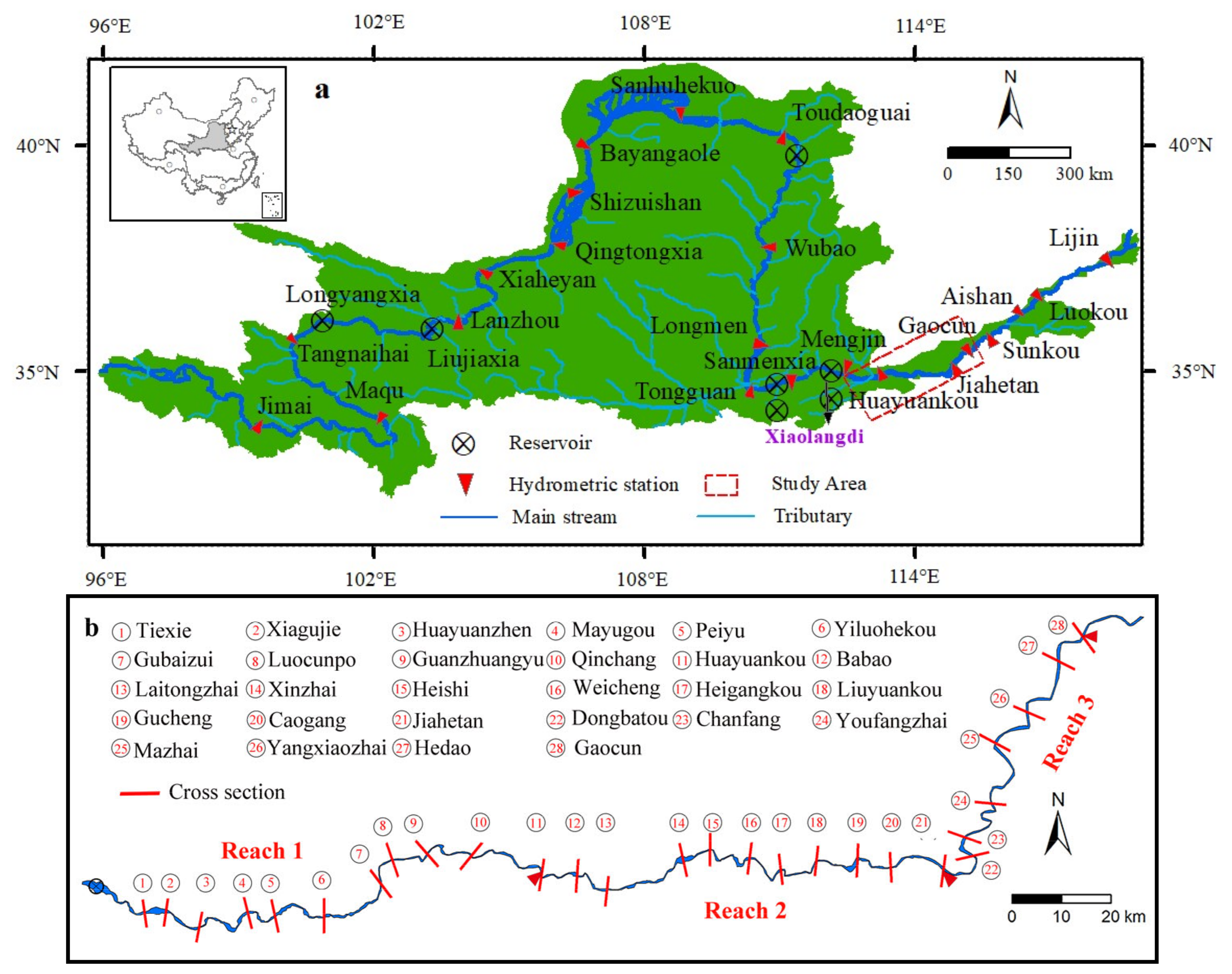
2.1. Study Reach

The Yellow River (YR) is the second largest river in China, which has an important influence on the early human civilization. It originates from the Qinghai-Tibet Plateau and has a drainage area of 79.5 × 10⁴ km2 and a length of 5464 km [29,30]. The suspended sediment concentration of the YR is the highest in the world, and the annual sediment load accounted for approximately 6% of the sediment load in global rivers [31]. Figure 1a shows the overview of the YR Basin, and the lower Yellow River (LYR) is from Mengjin to Lijin. A huge amount of sediment deposited on the river bed of this reach, forming a phenomenon of a ‘secondary perched river’, which increased high flood risks to the downstream residents. The LYR can be divided into three reaches of wandering, transitional, and meandering according to the different characteristics of channel evolution [32,33]. The wandering reach is from Mengjin to GaoCun (GC) and the length of this reach was approximately 284 km, as shown in Figure 1a. The channel geometry of this reach is the broad-shallow type, and a majority of riverbanks in this reach are so erodible that bank retreat and severe lateral channel migration occurred frequently [34]. Twenty-eight sedimentation sections were set in the study reach, which are surveyed in May (pre-flood period) and October (post-flood period) annually to monitor channel deformation, as shown in Figure 1b. Three hydrometric stations were set to monitor discharges, sediment concentrations, and water stages in the study reach, including Huayuankou (HYK), Jiahetan (JHT), and GC [32]. The wandering reach can be further divided into three sub-reaches of Reach 1 (above HYK), Reach 2 (HYK-JHT), and Reach 3 (JHT-GC) with the boundaries of these stations (Figure 1b).

2.2. Data Source

Hydrological data were collected from the YRCC, including daily discharges, sediment concentrations, and water stages at the HYK, JHT, and GC stations in 1999–2018. The post-flood cross-sectional profiles at 28 sedimentation sections and channel scour volume in the wandering reach were also collected from the YRCC during the study period. It is estimated that the average annual sediment amount entering the wandering reach reduced sharply since 1999, which accounted for only 14% of the average annual sediment amount from 1986 to 1999. The average annual water volume showed a slight decrease from 276.5 × 10⁸ m3/a in 1986–1999 to 257.5 × 10⁸ m3/a in 1999–2018.

3. Methods

3.1. Calculation of River Bed Downcutting Depth

The variation in river bed downcutting depth can represent the changes in the location and magnitude of channel incision. In this study, the calculation method of the river bed downcutting depth can be divided into four steps. Firstly, the main-channel zones at 28 sedimentation sections should be determined in 1999–2018, and the determination principles can found referring to Xia et al. [32]. Secondly, we calculated the average bed elevations in the main channel for every sedimentation section annually according to the profiles of 28 sections. Thirdly, we calculated the difference in the average bed elevations between two adjacent years at a certain section, and the difference is defined as the section-scale annual downcutting depth ( Δ Z j ). The difference in the average bed elevations between the current year and 1999 at a certain section can be defined as the section-scale cumulative downcutting depth ( Z j ). Finally, we calculated the average of annual downcutting depths at 28 sedimentation sections, which is defined as the reach-scale annual downcutting depth ( Δ Z ¯ ). We also defined the average of the cumulative downcutting depths at 28 cross-sections as the reach-scale cumulative downcutting depth ( Z ¯ ). We used these parameters to analyze the spatial and temporal characteristics of channel incision at section- and reach-scales in the wandering reach from 1999 to 2018.

3.2. Determination of Water Stages at Certain Discharges

The multi-year variations in the water level at gauge stations can reasonably represent the tendencies of channel incision in rivers [35]. Stage–discharge curves reflect the relationship between water stages and flow discharges, which can also be used to extrapolate one variable from the other [36]. The determination method of water stages at low flows and high flows can be divided into two steps. Firstly, the daily water stages against discharges were plotted to attain the stage–discharge curves annually at the HYK, JHT, and GC stations from 1999 to 2018. The relationships between the discharges and water stages annually at the three hydrometric stations can be represented by logarithmic functions. Secondly, the water stages at certain discharges were calculated using the established functions of stage–discharge curves. In this study, 500 m3/s was used to calculate water stages at low flows and 3000 m3/s was used to calculate water stages at high flows. The variation in water stages from 1999 to 2018 at low and high flows at three hydrometric stations can also represent the process of channel incision in the wandering reach and three sub-reaches.

4. Results

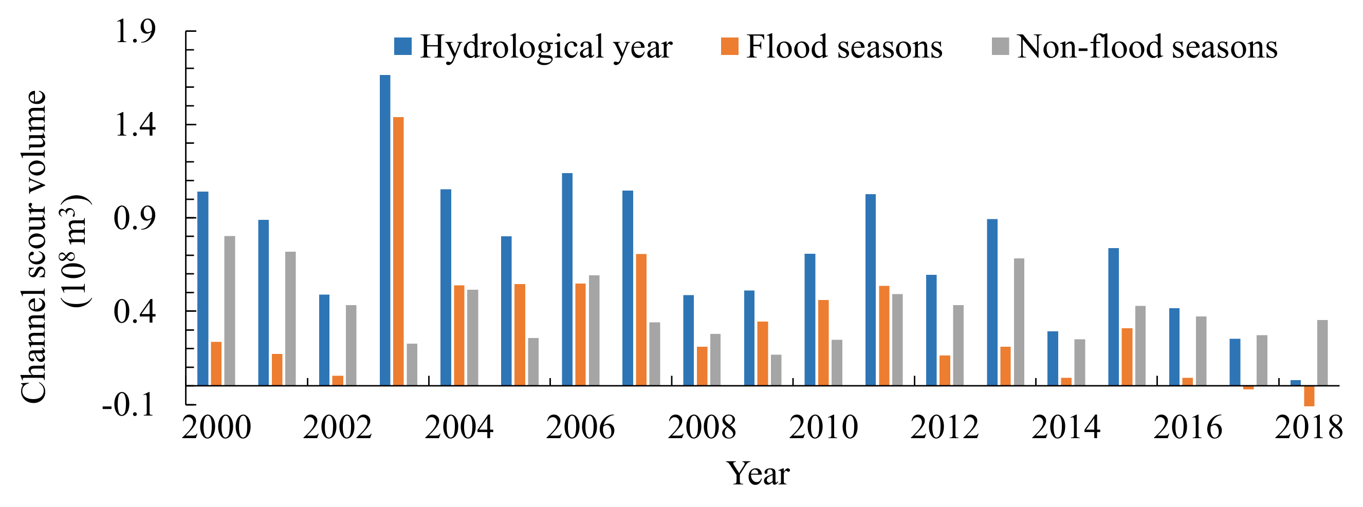
4.1. Changes in Channel Scour Volume

The clearwater release from the dam can cause the reach below the dam to degrade [37]. The LYR has undergone significant channel scour since the operation of the Xiaolangdi Reservoir, and the cumulative channel scour volume was approximately 20.3 × 10⁸ m3 in the whole reach from 1999 to 2018. The most intensive channel scour occurred in the wandering reach and the cumulative channel scour volume reached up to approximately 14.1 × 10⁸ m3 in this reach. In terms of the annual channel scour volume, the wandering reach underwent the most significant channel degradation in 2003, as shown in Figure 2, with the channel scour volume of 1.7 × 10⁸ m3. The average annual channel scour volume in 2000–2015 was approximately 0.84 × 10⁸ m3/a, but it showed a significant decrease in 2016–2018, with the value decreasing to 0.03 × 10⁸ m3 in 2018. Figure 2 also shows the variations in channel scour volumes during the flood seasons and non-flood seasons. It indicates that the wandering reach underwent channel scour during all non-flood seasons and the maximum channel scour volume during the non-flood seasons occurred in 2000, with the magnitude of 0.8 × 10⁸ m3. In 2000–2016, the wandering reach underwent channel scour during the flood seasons, and the maximum channel scour volume during the flood seasons occurred in 2003, with a magnitude of 1.4 × 10⁸ m3. Nevertheless, the channel transformed from scour to deposition during the flood seasons in 2017–2018, with the channel deposition volume of 0.3 × 10⁸ m3 in 2018. The average channel scour volumes during the non-flood seasons and flood seasons in the wandering reach were 0.41 × 10⁸ m3/a and 0.33 × 10⁸ m3/a, respectively, which indicates that channel scour was more intensive during the non-flood seasons from 2000 to 2018.

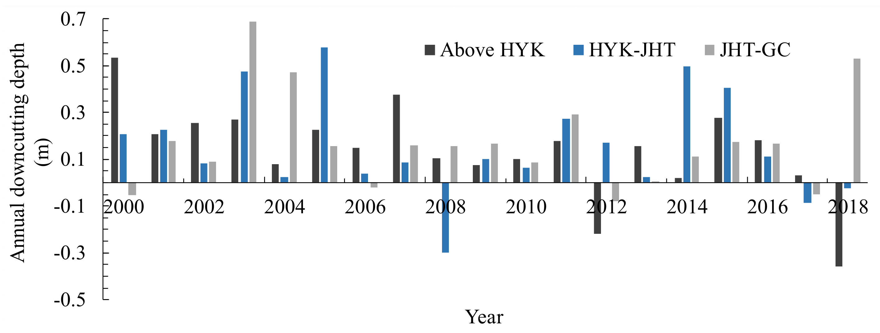
4.2. Changes in River Bed Downcutting Depth at the Section- and Reach-Scales

To investigate the characteristics of channel incision spatially and temporally in the wandering reach, the average bed elevations and the cumulative river bed downcutting depths at 28 sedimentation sections were calculated from 1999 to 2018 (Figure 3). The maximum value of Z j was about 4.2 m and it occurred in the Xiagujie section, which is located approximately 31.3 km downstream of the XLD dam. The minimum value of Z j was approximately 1.1 m and it occurred in the JHT section. Therefore, the cumulative downcutting depth at the section-scale varied rearkably along the wandering reach. The magnitude of channel incision was affected by the flow and sediment regime and channel boundary conditions at different sections. Figure 4 shows variations in the annual downcutting depths in three sub-reaches of the wandering reach from 2000 to 2018. It shows that channel incision began at the initial operation of the reservoir in Reach 1 (above HYK) and Reach 2 (HYK–JHT), but it began from 2001 in Reach 3 (JHT–GC), which indicates that there was a delayed response of channel downcutting to the reservoir operation downstream in this reach. In Reach 1, the maximum annual downcutting depth was approximately 0.54 m in 2000 and the channel underwent deposition in 2012 and 2018, with the deposition depths of 0.22 m and 0.36 m. In Reach 2, Δ Z ¯ reached up to the maximum value in 2005, with a magnitude of 0.58 m, and the channel underwent deposition in 2008, 2017, and 2018. In Reach 3, the annual downcutting depths were relatively large in 2003 and 2018, with the values of 0.69 m and 0.53 m, and the channel deposition depths in 2000, 2006, 2012, and 2017 were 0.05 m, 0.02 m, 0.08 m, and 0.05 m, respectively. In terms of the whole wandering reach, the maximum value of Δ Z ¯ was 0.45 m in 2003, because several floods occurred in the wandering reach in this year. The annual downcutting depths in the whole reach in 2000–2005 were greater than those in the later periods, which revealed that more intensive channel incision occurred in the initial years after the reservoir operation. According to the calculated data, the magnitude of the accumulative downcutting depth in the wandering reach was approximately 2.9 m from 1999 to 2018. In three sub-reaches, the magnitudes of Z ¯ were 2.6 m, 3.0 m, and 3.2 m, respectively, which revealed that the channel incision in the Reach 3 was more severe in the recent 20 years. Significant river bed downcutting was also reported in other alluvial rivers owing to upstream damming. Zheng et al. [20] found that the last 565 km of the Lowermost Yangtze River scoured about 1.2 m in bed elevation on average from 1998 to 2013. Smith et al. [18] investigated channel changes in the Saskatchewan River, and it indicates that the mean lowering of bed elevation reached 2 m within ten years after the E.B. Campbell Dam construction.

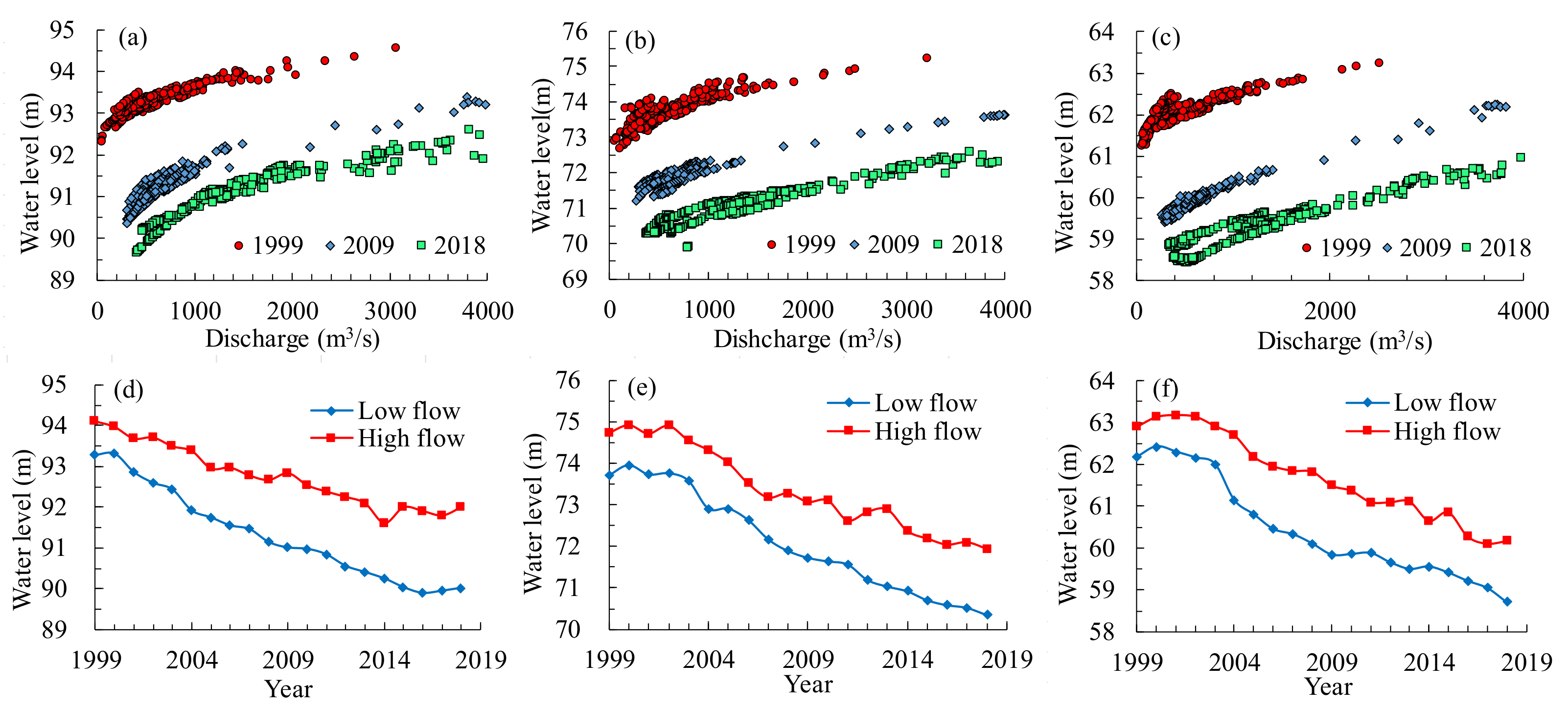
4.3. Changes in Water Stage

The decrease in water stages at certain discharges can also be an indicator of river channel incision. The stage–discharge curves were plotted at three gauge stations from 1999 to 2018, and Figure 5a–c shows the variation in stage–discharge curves in 1999, 2009, and 2018. It indicates that the relationships between water stages and flow discharges changed dramatically at these stations, and the water stages decreased sharply at the similar discharges after the reservoir operation. The water stages at low flows and high flows were calculated between 1999 and 2018 based on fitted logarithmic functions of stage–discharge curves, as shown in Figure 5d–f. At the HYK station (Figure 5d), the water stage at low flows reduced from 93.3 m in 1999 to 90.0 m in 2018, and the water stage at high flows reduced by 2.1 m during the study period. At the JHT station (Figure 5e), the water stages at both low and high flows changed very little from 1999 to 2002. In 2003–2018, there was a significant decrease in water stages from 73.8 m and 74.9 m to 70.4 m and 71.9 m at low flows and high flows, respectively. At the GC station (Figure 5f), the water stages at both low and high flows also did not change much from 1999 to 2002. In 2003–2018, the water stages reduced from 62.0 m and 62.9 m to 58.7 m and 60.2 m at low and high flows, respectively. It revealed that the lowering of water stages at the JHT and GC stations show a delay response to the reservoir operation. Figure 5d–f also indicates that the water stages at low flows decreased more than those at high flows at the three hydrometric stations from 1999 to 2018. At low flows, the water stage at the GC station decreased most after the reservoir operation, with the magnitude of 3.5 m. At high flows, the water stage at the JHT station decreased most, with a value of 2.8 m. The observed lowering of water stages as a result of channel incision was also documented in various rivers. It is reported that the lowering of flood water stage in the lower Pearl River was about 1.5 m in the late 1990s and about 2.0 m in the 2000s when compared with the floods of similar water discharge pre-1990s or in the early 1990s [10]. In the Rivers of the Polish Carpathians, the lowering of the minimum annual water stages was approximately 0.5–3.8 m over the twentieth century [12].

5. Discussion

Generally, the incoming flow and sediment regime were regarded as the major factors controlling channel evolution in alluvial rivers [37]. The temporal variation in channel adjustments is usually represented by functions of discharge, sediment concentration, and fluvial erosion intensity when significant channel scour occurred in alluvial rivers [34,38,39]. In this study, the fluvial erosion intensity ( η ) was used to represent the flow and sediment regime, and it can be expressed by η = Q ¯ 2 / S ¯ / 10 4 , where Q ¯ represents the annual mean flow discharge and S ¯ represents the annual mean sediment concentration. In order to investigate the influence of altered flow and sediment regime, the relationship between cumulative downcutting depth in the wandering reach and the annual fluvial erosion intensity at the HYK station was established during the study period, as shown in Figure 6a. It indicates that Z ¯ increased with an increase in η , and the relationship can be fitted for a logarithmic model, with a high square of correlation coefficient (R2) of 0.87. Previous studies also indicate that channel adjustments in alluvial rivers are a result of the cumulative effect of several consecutive years’ flow discharge and sediment load conditions [3,39,40]. Considering the cumulative effect, the relationships between Z ¯ and the previous n-year average fluvial erosion intensity were established, and it is found that the corresponding correlation degree attained the maximum value at n = 6. The relationship between Z ¯ in the wandering reach and the previous 6-year fluvial erosion intensity ( η ¯ 6 ) at the HYK station is shown in Figure 6b. The relationship was fitted for a logarithmic function: Z ¯ = 0.7485 × ln ( η ¯ 6 ) 0.2532 , with a corresponding R2 of approximately 0.98. This reveals that the previous 6-year average fluvial erosion intensity was the major parameter controlling channel incision in the wandering reach in the recent 20 years. The annual mean flow discharges and the annual mean sediment concentrations at the HYK, JHT, and GC stations were used to calculate η ¯ 6 in Reach 1, Reach 2, and Reach 3, respectively. Figure 7 shows the relationships between Z ¯ and η ¯ 6 in three sub-reaches, and it indicate that the previous 6-year average fluvial erosion intensities were closely related to the cumulative river bed downcutting depths, with all of the corresponding square of correlation coefficients above 0.92 using logarithmic functions. Therefore, the previous 6-year average fluvial erosion intensities at three hydrometric stations can be used to calculate Z ¯ in the wandering reach and these sub-reaches during the study period.
Figure 8 shows comparisons between the observed reach-scale cumulative river bed downcutting depths and the calculated data using established functions in the wandering reach and three sub-reaches. It shows that the changing processes of the calculated cumulative downcutting depths agreed well with those of the observed data during the study period. However, there were some differences between the calculated cumulative downcutting depths and the observed data in some years. This indicates that channel incision in the wandering reach can be affected by other factors, although η ¯ 6 was the key parameter. For example, continuous channel incision in the wandering reach of the LYR can cause the river bed armoring. According to statistics, the median diameters of bed material at the HYK, JHT, and GC stations increased by 265%, 98%, and 70%, respectively, from 1999 to 2018. The river bed armoring may mitigate or prevent the degree of channel incision in the wandering reach to some extent. In addition, channel geometry, channel slope, and other channel boundary factors can also have impacts on the process of channel incision in the wandering reach. Therefore, the proposed empirical functions can only be applicable to the rapid channel incision period in the wandering reach and three sub-reaches. In general, this study highlights the spatial and temporal characteristics of channel incision in the wandering reach of the LYR in the recent 20 years, and illustrates the key factor controlling the process of channel incision. Nevertheless, fully understanding the influencing factors and accurately predicting the process of channel incision need more investigation in the near future.

6. Conclusions

The XLD Reservoir operation has caused channel degradation in the wandering reach of the LYR, with the corresponding cumulative channel scour volume of approximately 14.1 × 10⁸ m3 from 1999 to 2018. Rapid channel incision occurred in the wandering reach, with the magnitude of the cumulative river bed downcutting depth of approximately 2.9 m from 1999 to 2018. The magnitude of channel incision varied greatly along the whole reach. In three sub-reaches, Reach 3 had the maximum cumulative river bed downcutting depth of 3.2 m and Reach 1 had the minimum cumulative downcutting depth of 2.6 m. Water stages decreased significantly at both low flows and high flows at the three hydrometric stations of HYK, JHT, and GC in 1999–2018. At low flows, the water stage at the GC station decreased most after the reservoir operation, with the magnitude of 3.5 m. At high flows, the water stage at the JHT station decreased most, with the value of 2.8 m. The previous 6-year average fluvial erosion intensity is the major influencing factor controlling channel incision in the wandering reach, and empirical functions were established between cumulative river bed downcutting depths and the previous 6-year average fluvial erosion intensity in the wandering reach and three sub-reaches. The changing processes of the calculated cumulative downcutting depths using the proposed equations agreed well with the observed data, but the effects of other factors need to be considered in future studies in order to accurately predict the channel incision process.

Author Contributions

Formal analysis, J.L.; Project administration, J.L.; Methodology, J.L.; Data curation, Z.Z.; Investigation, B.X.; Writing—original draft, J.L.; Writing—review and editing, J.L. and Q.J. All authors have read and agreed to the published version of the manuscript.

Funding

This research was funded by the National Natural Science Foundation of China (Grant No. 52109102), Visiting Researcher Fund Program of State Key Laboratory of Water Resources and Hydropower Engineering Science in Wuhan University (Grant No. 2020HLG01), and the Blue Project of Yangzhou University.

Institutional Review Board Statement

Not applicable.

Informed Consent Statement

Not applicable.

Data Availability Statement

The data presented in this study are available upon request from the corresponding author.

Conflicts of Interest

The authors declare no conflict of interest.

References

  1. Huang, M.W.; Liao, J.J.; Pan, Y.W.; Cheng, M.-H. Rapid channelization and incision into soft bedrock induced by human activity—Implications from the Bachang River in Taiwan. Eng. Geol. 2014, 177, 10–24. [Google Scholar] [CrossRef]
  2. Dar, R.A.; Mir, S.A.; Romshoo, S.A. Influence of geomorphic and anthropogenic activities on channel morphology of River Jhelum in Kashmir Valley, NW Himalayas. Quat. Int. 2019, 507, 333–341. [Google Scholar] [CrossRef]
  3. Lyu, Y.W.; Fagherazzi, S.; Tan, G.M.; Zheng, S.; Feng, Z.; Han, S.; Shu, C. Hydrodynamic and geomorphic adjustments of channel bars in the Yichang-Chenglingji Reach of the Middle Yangtze River in response to the Three Gorges Dam operation. CATENA 2020, 193, 104628. [Google Scholar] [CrossRef]
  4. Brenna, A.; Surian, N.; Mao, L. Alteration of gravel-bed river morphod-ynamics in response to multiple anthropogenic disturbances: Insights from the sediment-starved Parma River (northern Italy). Geomorphology 2021, 389, 107845. [Google Scholar] [CrossRef]
  5. Lou, Y.Y.; Dai, Z.J.; Lu, X.X.; Li, D. Anthropogenic pressures induced hydromorphodynamic changes of riverine islands in the Upper Jingjiang reach along the Changjiang (Yangtze) River. CATENA 2022, 217, 106488. [Google Scholar] [CrossRef]
  6. Elznicová, J.; Kiss, T.; Sipos, G.; Faměra, M.; Štojdl, J.; Váchová, V.; Grygar, T.M. A central European alluvial river under anthropogenic pressure: The Ohře River, Czechia. CATENA 2021, 201, 105218. [Google Scholar] [CrossRef]
  7. Simon, A.; Rinaldi, M. Disturbance, stream incision, and channel evolution: The roles of excess transport capacity and boundary materials in controlling channel response. Geomorphology 2006, 79, 361–383. [Google Scholar] [CrossRef]
  8. Surian, N.; Rinaldi, M. Morphological response to river engineering and management in alluvial channels in Italy. Geomorphology 2003, 50, 307–326. [Google Scholar] [CrossRef]
  9. Poesen, J.; Nachtergaele, J.; Verstraeten, G.; Valentin, C. Gully erosion and environmental change: Importance and research needs. CATENA 2003, 50, 91–133. [Google Scholar] [CrossRef]
  10. Lu, X.X.; Zhang, S.R.; Xie, S.P.; Ma, P.K. Rapid channel incision of the lower Pearl River (China) since the 1990s as a consequence of sediment depletion. Hydrol. Earth Syst. Sci. 2007, 11, 1897–1906. [Google Scholar] [CrossRef]
  11. Shields, F.D.; Lizotte, R.E.; Knight, S.S.; Cooper, C.M.; Wilcox, D. The stream channel incision syndrome and water quality. Ecol. Eng. 2010, 36, 78–90. [Google Scholar] [CrossRef]
  12. Wyżga, B.; Zawiejsk, J.; Pawlikc, R.A. Impact of channel incision on the hydraulics of flood flows: Examples from Polish Carpathian rivers. Geomorphology 2016, 272, 10–20. [Google Scholar] [CrossRef]
  13. Kondolf, G.M.; Swanson, M.L. Channel adjustments to reservoir construction and gravel extraction along Stony Creek, California. Environ. Geol. 1993, 21, 256–269. [Google Scholar] [CrossRef]
  14. Brandt, S.A. Classification of geomorphological effects downstream of dams. CATENA 2000, 40, 375–401. [Google Scholar] [CrossRef]
  15. Grant, G.E. The geomorphic response of gravel-bed rivers to dams: Perspectives and prospects. In Gravel-Bed Rivers: Processes Tools Environments; Church, M., Pascale, M.B., Roy, A.G., Eds.; John Wiley & Sons Ltd.: Hoboken, NJ, USA, 2012; pp. 165–181. [Google Scholar]
  16. Bravard, J.P.; Kondolf, G.M.; Piégay, H. Environmental and societal effects of channel incision and remedial strategies. In Incised River Channels; Darby, S.E., Simon, A., Eds.; Wiley: New York, NY, USA, 1999; pp. 303–341. [Google Scholar]
  17. Phillips, J.D.; Slattery, M.C.; Musselman, Z.A. Channel adjustments of the lower Trinity River, Texas, downstream of Livingston Dam. Earth Surf. Process. Landf. 2005, 30, 1419–1439. [Google Scholar] [CrossRef]
  18. Smith, N.D.; Morozova, G.S.; Arlucea, M.P.; Gibling, M.R. Dam-induced and natural channel changes in the Saskatchewan River below the E.B. Campbell Dam, Canada. Geomorphology 2016, 269, 186–202. [Google Scholar] [CrossRef] [Green Version]
  19. Lai, X.; Yin, D.; Finlayson, B.L.; Wei, T.; Li, M.; Yuan, W.; Yang, S.; Dai, Z.; Gao, S.; Chen, Z. Will river erosion below the Three Gorges Dam stop in the middle Yangtze? J. Hydrol. 2017, 554, 24–31. [Google Scholar] [CrossRef]
  20. Zheng, S.W.; Xu, Y.J.; Cheng, H.Q.; Wang, B.; Xu, W.; Wu, S. Riverbed erosion of the final 565 kilometers of the Yangtze River (Changjiang) following construction of the Three Gorges Dam. Sci. Rep. 2018, 8, 11917. [Google Scholar] [CrossRef]
  21. Rinaldi, M.; Wyżga, B.; Surian, N. Sediment mining in alluvial channels: Physical effects and management perspectives. River Res. Appl. 2005, 21, 805–828. [Google Scholar] [CrossRef] [Green Version]
  22. Kheir, R.B.; Wilson, J.; Deng, Y.X. Use of terrain variables for mapping gully erosion susceptibility in Lebanon. Earth Surf. Process. Landf. 2007, 32, 1770–1782. [Google Scholar] [CrossRef]
  23. Shit, P.K.; Paira, R.; Bhunia, G.; Maiti, R. Modeling of potential gully erosion hazard using geo-spatial technology at Garbheta block, West Bengal in India. Modeling Earth Syst. Environ. 2015, 1, 2. [Google Scholar] [CrossRef]
  24. Walker, S.J.; Wilkinson, S.N.; van Dijk, A.I.J.M.; Hairsine, P.B. A multi-resolution method to map and identify locations of future gully and channel incision. Geomorphology 2020, 358, 107115. [Google Scholar] [CrossRef]
  25. Chu, Z.X. The dramatic changes and anthropogenic causes of erosion and deposition in the lower Yellow (Huanghe) River since 1952. Geomorphology 2014, 216, 171–179. [Google Scholar] [CrossRef]
  26. Kong, D.; Latrubesse, E.M.; Miao, C.; Zhou, R. Morphological response of the Lower Yellow River to the operation of Xiaolangdi Dam, China. Geomorphology 2020, 35, 106931. [Google Scholar] [CrossRef]
  27. Lu, M.W.; Zhao, Q.H.; Ding, S.Y.; Wang, S.; Hong, Z.; Jing, Y.; Wang, A. Hydro-geomorphological characteristics in response to the water-sediment regulation scheme of the Xiaolangdi Dam in the lower Yellow River. J. Clean. Prod. 2022, 335, 130324. [Google Scholar] [CrossRef]
  28. Liu, W.; Wang, S.J.; Sang, Y.F.; Ran, L.; Ma, Y. Effects of large upstream reservoir operations on cross-sectional changes in the channel of the lower Yellow River reach. Geomorphology 2021, 387, 107768. [Google Scholar] [CrossRef]
  29. Miao, C.Y.; Kong, D.X.; Wu, J.W.; Duan, Q. Functional degradation of the water-sediment regulation scheme in the lower Yellow River: Spatial and temporal analyses. Sci. Total Environ. 2016, 551–552, 16–22. [Google Scholar] [CrossRef] [PubMed]
  30. Wu, N.; Liu, S.M.; Zhang, G.L.; Zhang, H.M. Anthropogenic impacts on nutrient variability in the lower Yellow River. Sci. Total Environ. 2021, 755, 142488. [Google Scholar] [CrossRef] [PubMed]
  31. Wang, H.; Yang, Z.; Saito, Y.; Liu, J.P.; Sun, X.; Wang, Y. Stepwise decreases of the Huanghe (Yellow River) sediment load (1950-2005): Impacts of climate change and human activities. Glob. Planet. Chang. 2007, 57, 331–354. [Google Scholar] [CrossRef]
  32. Xia, J.Q.; Li, X.J.; Li, T.; Zhang, X.; Zong, Q. Response of reach-scale bankfull channel geometry in the Lower Yellow River to the altered flow and sediment regime. Geomorphology 2014, 213, 255–265. [Google Scholar] [CrossRef]
  33. Bi, N.S.; Sun, Z.Q.; Wang, H.J.; Wu, X.; Fan, Y.; Xu, C.; Yang, Z. Response of channel scouring and deposition to the regulation of large reservoirs: A case study of the lower reaches of the Yellow River (Huanghe). J. Hydrol. 2019, 568, 972–984. [Google Scholar] [CrossRef]
  34. Li, J.; Xia, J.Q.; Zhou, M.R.; Deng, S.; Zhang, X. Variation in reach-scale thalweg-migration intensity in a braided reach of the lower Yellow River in 1986-2015. Earth Surf. Process. Landf. 2017, 42, 1952–1962. [Google Scholar] [CrossRef]
  35. Wyżga, B. A review on channel incision in the Polish Carpathian rivers during the 20th century. Dev. Earth Surf. Process. 2007, 11, 525–553. [Google Scholar]
  36. Chua, S.D.X.; Lu, X.X. What can stage curves tell us about water level changes? Case study of the Lower Mekong Basin. CATENA 2022, 216, 106385. [Google Scholar] [CrossRef]
  37. Julien, P.Y. River Mechanics; Cambridge University Press: Cambridge, UK, 2002. [Google Scholar]
  38. Xia, J.Q.; Li, J.; Carling, P.A.; Zhou, M.; Zhang, X. Dynamic Adjustments in Bankfull Width of a Braided Reach. Proc. Inst. Civ. Eng.Water Manag. 2019, 172, 207–216. [Google Scholar] [CrossRef]
  39. Wu, B.S.; Xia, J.Q.; Fu, X.D.; Zhang, Y.; Wang, G. Effect of altered flow regime on bankfull area of the lower Yellow River, China. Earth Surf. Process. Landf. 2008, 33, 1585–1601. [Google Scholar] [CrossRef]
  40. Wu, B.S.; Zheng, S.; Thorne, C.R. A general framework for using the rate law to simulate morphological response to disturbance in the fluvial system. Prog. Phys. Geogr. 2012, 36, 575–597. [Google Scholar] [CrossRef]
Figure 1. Overview of the study reach: (a) the Yellow River Basin and (b) sketch of the wandering reach.
Applsci 12 11983 g001
Figure 2. Channel scour volumes in the wandering reach from 2000 to 2018.
Applsci 12 11983 g002
Figure 3. Cumulative river bed downcutting depths at 28 sedimentation sections in 1999–2018.
Applsci 12 11983 g003
Figure 4. Variations in the annual river bed downcutting depths in three sub-reaches of the wandering reach from 2000 to 2018.
Applsci 12 11983 g004
Figure 5. Variation in the stage–discharge curves and water stages from 1999 to 2018: (ac) stage–discharge curves at the HYK, JHT, and GC stations; (df) water stages at low and high flows at the HYK, JHT, and GC stations.
Applsci 12 11983 g005
Figure 6. Relationships between the cumulative downcutting depth in the wandering reach and flow and sediment regime: (a) the fluvial erosion intensity and (b) the previous 6-year average fluvial erosion intensity.
Applsci 12 11983 g006
Figure 7. Relationships between the cumulative downcutting depths and the previous 6-year average fluvial erosion intensities in three sub-reaches: (a) Reach 1; (b) Reach 2; and (c) Reach 3.
Applsci 12 11983 g007
Figure 8. Comparisons between the observed cumulative downcutting depths and the calculated data in the wandering reach and three sub-reaches: (a) the wandering reach; (b) Reach 1; (c) Reach 2; and (d) Reach 3.
Applsci 12 11983 g008
Publisher’s Note: MDPI stays neutral with regard to jurisdictional claims in published maps and institutional affiliations.

