Article

Road Infrastructure Challenges Faced by Automated Driving: A Review

1
Institute of Automotive Engineering, Graz University of Technology, Inffeldgasse 11/II, A-8010 Graz, Austria
2
Department of Traffic Signalling, Faculty of Transport and Traffic Sciences, University of Zagreb, Vukelćeva 4, 10000 Zagreb, Croatia
3
AKKA I&S, 3 Av du Centre, 78280 Guyancourt, France
*
Authors to whom correspondence should be addressed.
Appl. Sci. 2022, 12(7), 3477; https://doi.org/10.3390/app12073477
Submission received: 29 January 2022 / Revised: 24 March 2022 / Accepted: 25 March 2022 / Published: 29 March 2022
(This article belongs to the Special Issue Traffic Sign Detection and Recognition)

Abstract

:
Automated driving can no longer be referred to as hype or science fiction but rather a technology that has been gradually introduced to the market. The recent activities of regulatory bodies and the market penetration of automated driving systems (ADS) demonstrate that society is exhibiting increasing interest in this field and gradually accepting new methods of transport. Automated driving, however, does not depend solely on the advances of onboard sensor technology or artificial intelligence (AI). One of the essential factors in achieving trust and safety in automated driving is road infrastructure, which requires careful consideration. Historically, the development of road infrastructure has been guided by human perception, but today we are at a turning point at which this perspective is not sufficient. In this study, we review the limitations and advances made in the state of the art of automated driving technology with respect to road infrastructure in order to identify gaps that are essential for bridging the transition from human control to self-driving. The main findings of this study are grouped into the following five clusters, characterised according to challenges that must be faced in order to cope with future mobility: international harmonisation of traffic signs and road markings, revision of the maintenance of the road infrastructure, review of common design patterns, digitalisation of road networks, and interdisciplinarity. The main contribution of this study is the provision of a clear and concise overview of the interaction between road infrastructure and ADS as well as the support of international activities to define the requirements of road infrastructure for the successful deployment of ADS.

1. Introduction

Ensuring the health, livelihood and safety of people is a main concern in modern times. The World Health Organization reports that more than 1.3 million deaths are caused by road accidents [1]. Climate change is another concern that affects people’s health and life quality. In 2018, transport was responsible for 24% of global CO 2 emissions, of which most were from road passenger (45.1%) and road freight (29.4%) transport [2]. These concerns are being addressed, as reflected by megatrends in mobility such as electrification, shared mobility, connected mobility and automated driving. In this study, we focus on automated driving and, in particular, its link to road infrastructure. The primary goal of automated driving systems (ADS) is enhancing road safety. Eichberger et al. [3] showed, in 2011, that lane keeping assistance (LKA) would prevent 17% of fatal traffic accidents in Austria, and further enhance it by an additional 13%. Kusano et al. [4] investigated the influence of the forward collision warning (FCW) and lane departure warning (LDW) technology on traffic accidents. The authors concluded that FCW could prevent up to 69% of moderate to fatal driver injuries in rear-end collisions, and up to 22% of serious to fatal injuries caused by drift-out-of-lane crashes by using LDW. Benson et al. [5] provided research estimating the benefits of combining multiple advanced driver assistance systems (ADAS) on accident prevention. The research estimated that approximately 40% of all passenger-vehicle crashes, 37% of crashes involved injuries and 29% of deaths in crashes could be prevented. More recent ADAS technology such as intelligent speed assistance (ISA) has the potential to reduce accidents by 30% and deaths by 20%, see [6]. However, misuse of advanced technology potentially leads to distracted driving, which is already showing an increasing trend as an accident factor. Moreover, partial automation causes earlier signs of sleepiness than manual driving [7]. Therefore, developing highly reliable ADAS is essential.
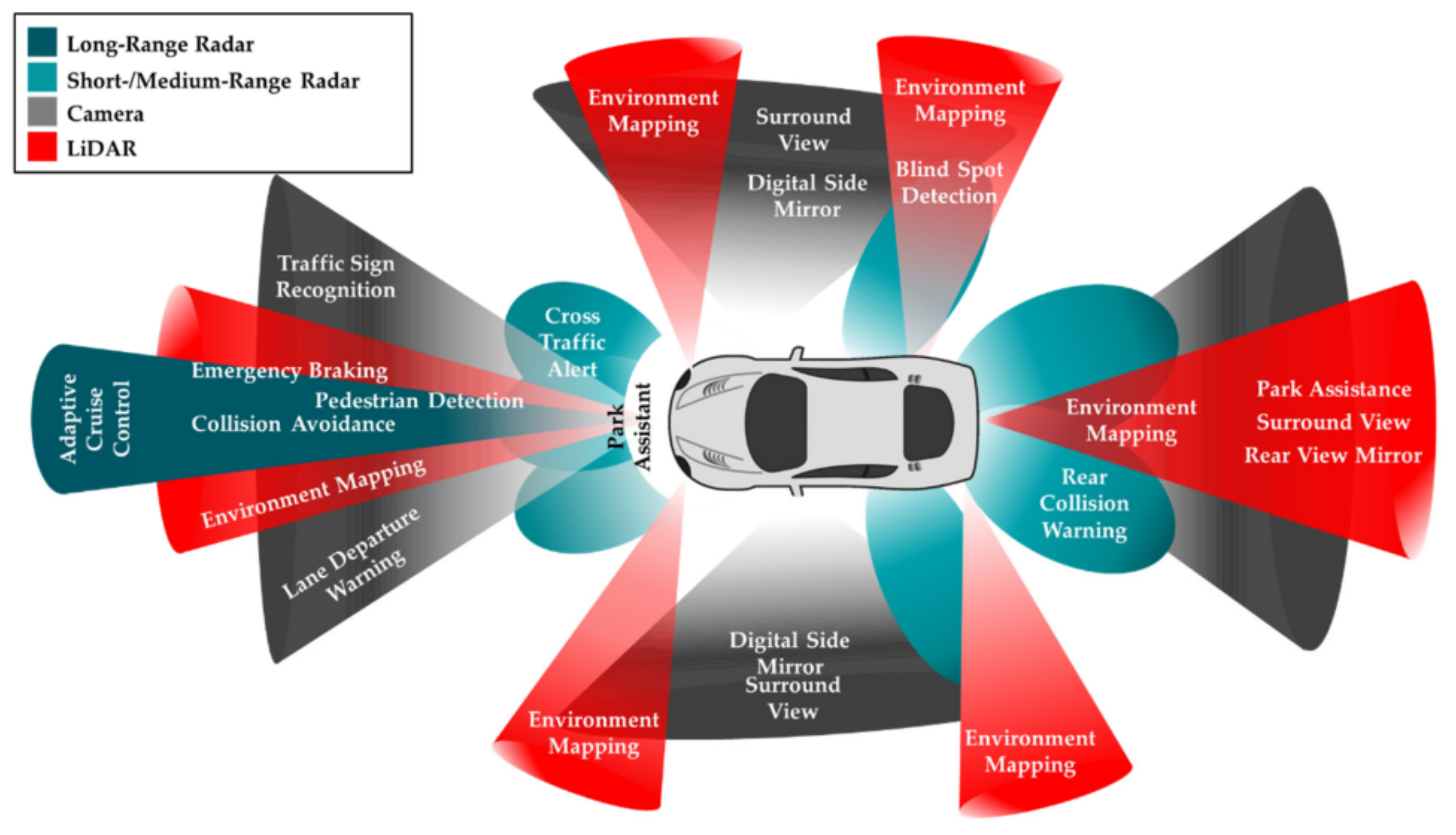
To achieve a high level of reliability, ADAS must be improved through onboard perception sensors, decision logic and controllers. However, this may not be enough. A certain improvement in the road infrastructure also plays a role in achieving the desired level of reliability and, yet, road infrastructure design has been guided by human drivers. Ambiguous traffic signs and road markings can lead to recognition failure by ADAS, regardless of its causes, design patterns, insufficiently maintained road infrastructure and nonharmonised appearances of traffic signs and road markings. Sensor fusion and digitalisation of the road network through vehicular communication and digital maps offer promising solutions to increase the reliability of the entire system by providing redundancy. Moreover, such an approach promotes the implementation of a safety culture as a vital part of establishing functional safety within an organisation and the life cycle of a product, as recommended by ISO 26262 [8].
The synergy between ADS and road infrastructure is a well-recognised topic for inquiry that has been increasingly addressed in recent years. One of the first comprehensive studies on this topic was conducted in the US as part of the National Cooperative Highway Research Program project [9]. The investigation was based on a field study examining the effect of the quality of longitudinal white and yellow road markings on the detectability and readability of machine vision (MV) systems in vehicles. Similar extensive studies were conducted by Austroads, which examined the performance of lane keeping assist (LKA) and traffic sign recognition (TSR) based on literature research, stakeholder consultation and on-road and off-road tests [10,11]. They aimed to specify recommendations for changes in Australian and New Zealand road infrastructure as well as to specify the level of required maintenance to support MV systems. Austroads also conducted extensive studies regarding connected and automated vehicles (CAVs) and infrastructure changes to support automated vehicles (AVs). The studies were conducted through five modules in which the authors examined road standards and gaps in physical and digital road infrastructure mostly related to traffic signs and road markings [12,13,14,15,16]. They concluded that, in Australia and New Zealand, only a few roads are fully suitable for automated driving over an extended distance. They also reported that the main reason why road authorities do not develop new standards is a lack of guidance and costs. In addition to those five modules, Austroads carried out a study on open data policies through literature research and interviews with stakeholders involved in the CAV data distribution chain [17]. The Permanent International Association of Road Congresses (PIARC) reported on challenges and opportunities for road operators and road authorities in the domain of CAVs [18,19]. The European Commission (EC) is also very active with EU-funded research and directives to support future trends in mobility. One such example is the INFRAMIX project that introduced so-called infrastructure support levels for automated driving (ISAD) to categorise road infrastructure based on its capability to support automated driving [20].
The focus of this paper is to provide a clear and concise overview of the synergy and existing limitations between road infrastructure and ADS. This paper is considered as an addition to reports that identify challenges and opportunities on this particular topic. An extensive technology survey and cost–benefit analysis are not in the scope of this paper. Our target audience is researchers that are new to the field, road authorities and bodies involved in international activities towards defining the requirements of road infrastructure for the successful adoption of ADS. Therefore, a basic overview of the state-of-the-art ADS would be a valuable source of information. That information could clarify the root cause of limits that ADS is facing. As a whole, the contributions of this paper are:
  • Provision of a short overview and the basic work principles of the most used and promising state-of-the-art ADS technologies.
  • Determination of the limitations and advances of ADS concerning road infrastructure (particularly for road markings and traffic signs).
  • Categorisation of the gaps and limitations according to challenges that should be addressed to support the transition towards higher levels of automation.
We approach the problem by first providing a short introduction of perception sensors and their basic work principles. This is the key to identifying the root cause of the limitations. In addition to this overview, sensor fusion, digital maps, and vehicular communication are introduced, which provide insight into emerging and promising technologies that aim to enhance ADS reliability. This state-of-the-art overview is given in Section 2. In Section 3, we introduce known limitations and advances in ADS technology from the perspective of road infrastructure. To address this topic properly, we selected traffic sign recognition systems (TSRS) and lane support systems (LSS) as reference advanced driver assistance systems (ADAS), which are essential and mature technologies for automated vehicles (AVs), and they are directly linked to the road infrastructure, which makes them an ideal candidate for this paper. Through the identified limitations, we identify gaps that could be addressed in future research activities and, moreover, those limitations are grouped into five challenges, and a summary of their mutual impacts and dependencies is included. The challenges are organised into the following categories: international harmonisation, revision in the maintenance of the road infrastructure, review of common design patterns, digitalisation of road networks, and interdisciplinarity. Discussion of the challenges is found in Section 4. The paper concludes with Section 6.
Publications considered for this review are reports compiled by governmental organisations or transport associations, classical peer-reviewed research publications, and web research to support findings with existing or emerging commercial solutions. As this is a fast-growing field, we focused our research on more recent studies published after 2015, including a few exceptions that we still considered state-of-the-art. Due to limited peer-reviewed academic publications related to the limitation and performance of the current ADAS regarding road infrastructure, the reports are considered as the primary information resource. Through exhaustive reports, usually associated with projects lead by governmental organisations, we were able to review the limitation and thresholds that could be considered as an adequate performance of ADS for given infrastructure bounds. Some of those publications are based on extensive literature research, stakeholder interviews, and experiments and, therefore, they provide not only scientific but also real-world experience. However, due to the lack of research papers that could distinguish the significance of the parameters of infrastructure regarding ADAS performance, we are not, at this stage, able to propose adequate thresholds for each parameter.

2. State of the Art

Many modern vehicles, equipped with ADAS, rely solely on onboard sensors, from which perception sensors are the only mechanisms that link road infrastructure and vehicle behaviour. Those systems show reliability drawbacks under inclement weather and light conditions, regardless of how technically advanced they are. This is usually acceptable if the human is entirely responsible for the driving task and the system is only used to support them (up to SAE L2). As mobility progresses towards higher automation, however, high reliability becomes imminent. One of the promising solutions to achieve high reliability is through system redundancy. At the vehicle level, redundancy is achievable with sensor fusion but, in the broader context of the traffic level, road network digitalisation is required. In this section, we will discuss perception sensors and sensor fusion as representative vehicle-level technologies, and digital maps and vehicular communication for traffic-level redundancy.

2.1. Sensors

The key components of self-driving cars are sensors. They collect data that are analysed onboard and used to control the vehicle motion. Sensors can be classified into two types. The first includes those sensors that measure the vehicle’s motion and dynamic state, such as accelerometers, gyroscopes and wheel speeds as well as all inputs to steering, braking or propulsion systems. States that are not measured directly such as the vehicle’s side-slip angle, which is a measure of the stability of the vehicle’s motion, are identified using state estimation techniques (refer to [21]). The second group of sensors aims to capture the relation with external objects and includes cameras, LiDAR and radar. These types of sensors are described in detail because they are relevant for the interaction with the road infrastructure, see Figure 1, [22].

2.1.1. Camera

The camera is the technological counterpart to human vision. Therefore, there is a logical and evolutionary explanation for why cameras are the most popular vision system used today. A camera is the most advanced vision technology when it comes to providing the highest resolution and amount of details of the scenery. However, its performance highly depends on the light passing through the lenses to the light-sensitive sensor. A lack or excess of light leads to overexposed or underexposed images from which, sometimes, it is impossible to retrieve image information. A similar effect is caused by abrupt changes in lighting conditions, when the camera needs some time to regain the contrast despite their high dynamic range. Today, in ADAS, different camera types are used to achieve intended functionality, such as mono and stereo camera systems, infrared and movable cameras for parking assistance-related applications (see Table 1).
Camera-based ADAS for detection and recognition of traffic signs and lane markings use the traditional and deep learning approaches. Traditional image processing techniques are usually connected with lane detection tasks and have been slowly replaced by deep learning methods in recent years. This approach can be described in the following structured chain of operations:
  • Image pre-processing: Firstly, unfavourable illumination effects and noise are reduced in images. Furthermore, colour-space transformation is performed in which RGB images are transformed to other formats such as HSV, HSL, LAB and YCbCr in order to enhance image contrast. Finally, pre-processing is concluded with the identification of relevant image parts or so-called region of interest (ROI).
  • Feature extraction: After the image is uncluttered and ROI is defined, relevant features are extracted. In this phase, the aim is to provide information to fit edge and lane models. To achieve this, different actions such as image perspective transformation and intensity histograms are used.
  • Edge and lane modelling: Based on the extracted features, the geometric elements are fitted. A popular method is the Hough transform.
  • Time integration: This phase aims to achieve temporal and positional consistency by integrating frames using lane tracking. For lane tracking algorithms, Kalman filters and particle filters are widely used due to their ability to predict an object’s future location. Finally, the vehicle motion, captured with odometry, GPU and IMU, is integrated with the geometrical models to identify previously detected lanes within the current frame.
Unlike the traditional methods, deep learning lane detection methods are learnable and gaining more popularity. This approach is usually based on segmentation by labelling image pixels, and the most commonly used algorithm is the convolution neural network (CNN). For a more detailed explanation of lane detection methods, the reader is referred to existing surveying literature [24,25,26,27], in which, both traditional and deep learning lane detection methods have been reviewed. In contrast to lane marking, algorithms for traffic signs can be divided into two phases: detection and recognition. Detection is responsible for identifying the presence and precisely locating a traffic sign on the image or, in other words, extracting the ROI. This phase achieves high performance as it uses information about the specific colours and shapes of traffic signs. Accordingly, detection algorithms can be grouped into five categories: colour-based, shape-based, colour- and shape-based, machine-learning-based and LiDAR-based methods [28]. After the sign is detected, recognition algorithms are applied to classify the meaning and category of traffic signs. For that purpose, the deep learning algorithms show the best performance, where CNN is again the most popular algorithm. Along with those two phases, the tracking phase can also be added [29]. This phase is responsible for keeping track of the signs in which multiple detection of the same sign is avoided, as are false positive cases.

2.1.2. Radar

The first experiments with automotive radar took place in the late 1950s [30]. Due to its insensitivity to harsh light and adverse weather conditions and ability to directly measure distance, radial velocity, and the angle of the target, radar is nowadays widely used in the field of active safety. Due to the narrower field of view (FOV), a combination of multiple radars is often required to cover a larger detection area (see Figure 1). Meanwhile, recognition errors arise because the radar provides less point cloud information and, thus, does not provide a detailed picture of the object. They can be classified according to the detection distance as long-range radar (LRR), mid-range radar (MRR), or short-range radar (SRR). Another categorisation can be according to technology. The most common radar technology used for automotive applications is frequency modulated continuous wave (FMCW) radar, and another type is unmodulated continuous wave (CW) radar [31]. Due to the need for radars with higher capabilities, a new high-resolution 4D radar was introduced. For more detailed explanations on various radar systems, see Table 2.

2.1.3. LiDAR

LiDAR was introduced in 1930 by the Irish physicist Edward Hutchinson Synge. Since then, it has been used in a wide range of applications for geology, geography, archaeology, aircraft industries and more. With the development of automated driving, it has imposed itself as a sensory system for scenery perception. LiDAR works on the time-of-flight principle shown in Figure 2, in which infrared laser pulses are emitted at a high frequency and reflected by the environment. The reflected optical signals are received by photodiodes. The time that passes between emitting and receiving is directly proportional to distance based on the speed of light. Therefore, the distances from surrounding objects are easily collected using LiDAR.
LiDAR outputs a point cloud (PC) as a collection of points that hold information such as x, y and z coordinates, intensity, time and much more [36]. Intensity is the reflectivity of the object from which the laser beam bounces and is affected by scan angle, range, surface roughness, surface compound and moisture content [37]. LiDAR demonstrates superiority over cameras in 3D data collection and less sensitivity to lighting conditions but still suffers under adverse weather conditions. Before deep learning became popular, traditional machine learning methods were mainly used for PC classification and detection. The idea of many detection algorithms is to conduct ground segmentation and then clustering. Finally, the clustered PC is identified. Moreover, many algorithms firstly map the point cloud data into a two-dimensional plane before recognition to improve calculation efficiency. Since 2014, with the advancement of object detection algorithms such as Fast RCNN, YOLO and SSD [38], the accuracy of PC recognition has improved. Therefore, point cloud object detection has also gradually shifted to the field of deep learning. Since deep neural networks can detect the current frame based on multiple consecutive frames of data, this approach can increase the stability of the algorithm output results, reduce the complexity of subsequent tracking algorithms, and improve the robustness of the overall perception system. To make the most of them, the LiDARs for ADAS come in different forms, which are shown in Table 3.

2.1.4. Sensor Fusion

Sensor fusion brings together inputs from multiple radars, LiDAR and cameras to balance the strengths of different sensors such that vehicle systems can use this information to support more complex ADAS.
The basic principle of multi-sensor information fusion technology is similar to integrated information processing by the human brain. The multi-level and multi-spatial information of various sensors is processed in a complementary and optimal combination to eventually produce a consistent interpretation of the observed environment.
This not only takes advantage of the synergistic operation of multiple sensors but also allows synthesising data from other information sources to improve the intelligence of the entire sensor system.
The fusion technology trend currently has two mainstream solutions: early and late fusion. Figure 3 illustrates a typical late fusion architecture, where each sensor independently processes the generated raw data and has its own independent perception algorithm. When all the sensors have generated target data, the central processor then performs data fusion.
Furthermore, early fusion (low level) was difficult to implement until a few years ago because the amount of processing required was huge. With the development of automotive electronic and electrical architecture and the popularity of domain controllers; however, this approach is expected to have significant growth in the future, as shown in Figure 4. There is only one algorithm for the perception of fused multi-dimensional integrated data in this architecture. The fused data are similar to a super sensor in the original layer that fuses all the data. This sensor can sense infrared light and has the ability to sense RGB and detect LiDAR 3D information. Finally, a result layer will be output in the detection results.

2.2. Digital Maps

In contrast to navigation maps, digital maps hold additional contextual information, such as information regarding speed limits, road topology information, traffic signs, traffic congestion, signal phase and more. However, they are a layer built on top of the basic maps and navigation maps and can come as a standalone or as part of navigation. The accompanying number of layers and details of the context depend on the level of automation they support, see Figure 5.
Maps that support up to SAE Level 2 of automation normally require road-level accuracy, which means that an accuracy of several meters is sufficient. Such maps used in ADAS include intelligent speed assistance (ISA), adaptive cruise control (ACC), lane keeping assist (LKA) and predictive powertrain control (PPC). Yet, for SAE Level 2+, those maps are not enough, and lane-level accuracy is needed for such advanced systems; therefore, so-called high definition (HD) maps were introduced. These maps offer centimetre precision, so they can be used for localisation tasks. However, due to the lack of vehicles equipped with the ADAS of a higher automation level, it is economically unjustified for map makers requiring commercial solutions, so HD maps currently tend to be restricted to research purposes. Despite that, the map makers such as TomTom, HERE, Bosch, and others in collaboration with car manufacturers, are actively working on scanning environments to collect all information, and it can be presumed that they already have some solutions on the shelf [41,42]. There are several ways in which a vehicle could be provided with those maps. One way is that they can be stored directly within a vehicle, while the other way is cloud-based solutions. That means the maps are offered through vehicle manufacturers’ cloud or are directly streamed from map providers. The benefit of streaming maps is the real-time service and up-to-date information. Those maps would be updated via crowdsourcing, which uses data collected through public and private vehicles and automatically sends them to the cloud, where they are merged with already existing maps [43,44]. Besides having real-time information about the road and traffic ahead, HD maps offer redundancy for onboard sensors and support localisation, perceptions beyond FOV and more precise path planning. Those are the main fields of their application according to [45], and a summary is provided in Table 4.

2.3. Vehicular Communication

Vehicular communication, along with digital maps, is another component of the digitalisation of road networks. It is generally described as vehicle-to-everything (V2X), though that is a collection of more specific communication types such as vehicle-to-pedestrian (V2P), vehicle-to-network (V2N), vehicle-to-vehicle (V2V), vehicle-2-infrastructure (V2I) and more, see Figure 6.
From the perspective of the road infrastructure, V2N that sends and streams information from the cloud and V2I for direct communication with infrastructure are of high importance. The first commercial service of V2I was traffic light information, offered by Audi in 2016 in Las Vegas [46]. This service provides timely information about traffic light state via 4G/LTE, which is then used to support drivers in adapting their speed such that they can catch a green light. Such services can help in optimising traffic flow and fuel consumption by providing information to driver or road authorities such that they can optimise the duration of traffic light phases to achieve the best performance. Currently, many V2N and V2I applications are in consideration, such as in road works or warning of road obstacles ahead, congestion information, tollgate information, merging support, left turn assist, spot weather impact, queue warning and more [19]. However, higher automation levels place higher demands on data precision, latency and transfer data rate. Commonly, communication is divided into short-range and long-range broadcasts.
Short-range communication is handled with an intelligent transportation system (ITS-G5) and dedicated short-range communication (DSRC), which are two vehicular communication protocols that use the allocated 5.9 GHz spectrum band. Both are based on the IEEE 802.11p physical layer that adds wireless access in vehicular environments (WAVE) to the IEEE 802.11 standard. Those protocols show sufficient latency for safety applications of 10 ms at 300 m range with no more than 100 users/km 2 [47]. Higher ranges and vehicle density are possible but at the expense of performance. Newer cellular technology C-V2X, offered by the 3rd Generation Partnership Project (3GPP), shows improvement through higher flexibility and scalability than ITS-G5 or DSRC [47,48,49]. Regarding the long ranges of around 2000 m, cellular communication such as 4G/LTE/5G can be used. Yet, for some safety-related applications, 4G and LTE do not have sufficient capabilities such as in terms of low latency or speed. Therefore, there is much expectation of 5G, which has a latency lower than 1 ms as well as a high data rate of up to 4.5 Gb/s [50]. However, technology based on 5G, including C-V2X, is still rather restricted to research purposes, but they have already attracted huge attention. In 2016, the 5G Automotive Association (5GAA) was founded by AUDI AG, BMW Group, Daimler AG, Ericsson, Huawei, Intel, Nokia, and Qualcomm Incorporated. The main idea is to connect telecommunication and car manufacturers, which in the meantime have attracted the attention of more than 130 automotive manufacturers, tier-1 suppliers, chipset/communication system providers, mobile operators and infrastructure vendors that have joined 5GAA [51].

3. Limitations and Advances of Road Infrastructure

In previous sections, we looked at the basic work principles of perception sensors, which imply that the light, weather and reflectivity of the objects influence their performance. In this chapter, we will focus on two mainly camera-based ADAS, traffic sign recognition systems (TSRS) and lane support systems (LSS), which is the common name for systems based on lane detection. TSRS and LSS are both mature technologies and, to some extent, depend on the quality of the road infrastructure; therefore, they are ideal candidates for closer examination.

3.1. Traffic Sign Recognition System (TSRS)

3.1.1. Limitations

TSRS is not a recent technology and has been present in the market for more than a decade. However, its performance needs to be improved, and it needs to be integrated into more advance ADAS such as intelligent speed assist (ISA) that automatically adapts the speed of a vehicle to the recognised speed limits. Taking into account that TSRS performance is bounded by sensors and algorithms, it can be expected to suffer from the same issues as a camera or poorly trained model. Therefore, we categorised limitations of TSRS into whether they were caused by environmental conditions, insufficient maintenance or design.
Harsh weather, lack or excess of light, backgrounds with a similar colour as a sign, or the presence of physical obstructions are environment parameters that significantly influence the performance of TSRS due to limitations of the camera itself and obstructed FOV. Many studies indicate that the performance of ADAS has been rarely investigated under challenging weather and lighting conditions as well as the lack of databases for training algorithms for those conditions. In their survey study on traffic sign detection, tracking and classification, the authors identified variable lighting conditions as one of the main issues affecting reliable detection [29]. The reason is that detection is highly dependent on the colours of signs, whose appearance can be greatly affected by variations in illumination. Studies [52,53] investigating the performance of the commonly used methods for TSRS are based on deep learning architecture and existing datasets regarding challenging conditions. The challenging conditions that have been considered include lens blur, dirty lens, darkening, shadow, noise, code errors, snow, rain, haze, exposure and more. The authors concluded that lens blur, exposure, codec errors and precipitation, such as rain or snow, lead to significant degradation in performance of the commonly used methods. A recent study [54] indicates the impact of rain on object detection has not been sufficiently studied. Nevertheless, the authors highlighted that one of the most challenging tasks is to isolate raindrops and restore the information in scenes occluded by rain. Despite some inclement weather, not all signs have the same detection rate. Signs with a specific shape, such as yield or stop, are very well detected and recognised, while speed limits, which have numerals that need to be recognised, are slightly more challenging [55]. However, the same study showed that, to some extent, the performance of TSRS can be improved by training the models on a bigger set, even for inclement weather. Another significant parameter is reflectivity, especially during low visibility conditions. A recent study showed that signs of a higher retroreflection class experience improved detection and readability by TSRS. Different retroreflective materials (sheeting) return different percentages of light back to the source (drivers/camera) and thus impact the overall night-time visibility of signs [55]. With the exception of retroreflection, studies have indicated that even small changes in the appearance of signs, caused by damage, or by their irregular positioning may lead to problems and failures in TSRS detection [11,56].
Electronic signs present another hurdle for ADAS, and their refresh rates are calibrated for the human eye. Often, when seen through the camera, electronic signs appear to flicker. However, this is not always the case, and some electronic signs are well recognised, so this is more a problem regarding sign manufacturers and standards that do not take ADAS into account when it comes to their refresh rates [11]. Another common issue is collocated signs with multiple meanings, such as signs on moving buses and trucks, weather, time or vehicle type-dependent signs as well as signs with additional text. Current ADAS are limited to shape, colours and learned signs, and additional text or adjacent signs of the same type increase the probability of detection failure. Failures in recognition also occur when signs have a similar appearance regarding shape and colours or they appear in the FOV of the camera despite not being applicable for the road on which the vehicle is driving [11]. Table 5 summarises the limitations as grouped into environment, maintenance and design.

3.1.2. Advances

How technology copes with limitations introduced in the previous section can be viewed from two perspectives: vehicle and road. One way to increase the reliability of TSRS from the vehicle perspective is to introduce hardware and software redundancy by integrating LiDAR together with the camera. LiDAR is capable of precisely defining the position of 3D objects and includes their reflectivity information, which adds another layer to detection and recognition [57]. Therefore, sensor fusion has great potential for increasing the accuracy in sign interpretation. From the road perspective, using a higher grade of retroreflective material/sheeting on traffic signs improves overall visibility under all environmental conditions and increases robustness regarding sign degradation over time [55,58]. Improving traffic signs or sensor systems by itself, however, will not fully eliminate the previously mentioned limitations regarding inclement weather or damaged traffic signs. Therefore, to link those two worlds, V2N and V2I solutions are needed. The majority of speed assistance systems that rely on TSRS, among others, are however integrated with the spatial mapping system with satellite position and databases of speed zones [11]. Yet, further development of digital maps, smart sign technology and short-range communication has great potential to introduce a redundant system for both road infrastructure and MV and allow the system to work under different environmental conditions and cope with signs that have a distorted appearance.
In the last decade, other technologies have also been applied to traffic signs. 3M introduced the “invisible” 2D barcoded road sign. The idea is to place the IR spectral barcode on the traffic sign, which makes it invisible to humans but readable by ADAS up to a distance of approximately 90 m [59]. RFID technology is another case study. It offers a short-range solution, up to approximately 30 m, for localisation and maintenance tasks [60,61,62]. Table 6 summarises the advances in technology regarding TSRS.

3.2. Lane Support Systems (LSS)

3.2.1. Limitations

ADAS that depend on lane detection, such as lane departure warning (LDW), lane-keeping assistance (LKA) or automatic emergency steering (AES), show limitations under adverse weather and lighting conditions similarly to other MV systems. In general, studies have shown that more problems are experienced in the detection of road markings by ADAS during daytime, due to visual clutter [10]. In daytime conditions, it has been highlighted that the optimal contrast ratio between markings and pavement is 3-to-1 [9,10]. On the other hand, contrary to humans, MV has fewer problems during the night-time. Namely, the contrast between markings and pavement is much more pronounced during the night-time, and even lower retroreflection levels of markings can produce adequate contrast ratio needed for MV. Overall, most studies suggest that, for proper functioning of MV during night-time, the retroreflectivity of road markings should be at least 100 mcd / lx / m 2 [9,10,63,64,65]. With the exception of the aforementioned, other conditions such as wet pavement, rain, fog, dirt, residual markings or other maintenance issues related to markings, or glances from oncoming traffic, may reduce the confidence rate of lane detection significantly [66]. Along with environmental and maintenance issues that affect not just ADS but also human drivers, the rethinking of some design patterns can lead to improved lane detection performance. Design issues are primarily related to the continuity of markings, configuration of the dashed lines as well as colour and width of the markings. Some of these issues, such as standardisation of the configuration of dashed lines, may be difficult to achieve, keeping in mind that countries (especially in Europe) have their own established practices and standards, and changing these would be a long a costly procedure. On the other hand, continuity, colour and the width of the markings could be addressed, and some countries are already proposing such changes (US with their proposal for new MUTCD, for example). It is evident that the continuity of markings is one of the crucial factors for MV detection. Furthermore, several studies investigated how an increase in lane marking width from 100 to 150 mm influences the detection rate, and it was concluded that there is a positive correlation between the confidence of detection and wider lane marking [67]. Other studies regarding colour imply that recognition shows better performance for white marking than yellow [9,65,66].

3.2.2. Advances

Aside from addressing design issues, mainly regarding the continuity, colour and width of markings, improvements in MV detection may be achieved using modern road marking technologies and techniques. For example, profiled or agglomerate road markings have improved visibility during wet and rainy conditions when there is a reduction in flooding or water drainage. Moreover, high-quality glass beads or all-weather markings should also increase the visibility of markings in diverse conditions ([68,69]).
There is also a tendency to develop smart road marking. One project that deals with this is the Safe Strip Project. Here, the micro/nano sensory system is incorporated into road markings to support V2I by providing information about the traffic ahead or environmental parameters essential for vehicle dynamics. Directly communication to vehicles is supported through onboard units or mobile phones in the case of non-equipped vehicles. This also offers benefits to road authorities via the collected data, which could greatly support predictive maintenance. It is also energy efficient as power supply comes from ambient sources [70,71,72,73].

4. Identification of Challenges

After reviewing the state-of-the-art and literature research, we identified five topics related to challenges in identification: international harmonisation of traffic signs and road markings, revision in the maintenance of the road infrastructure to support future mobility, review of current design patterns used for road infrastructure, digitalisation through digital maps and vehicular communication, and finally interdisciplinarity, which is needed to cope with jobs that may arise due to transition towards self-driving.

4.1. Harmonisation

Studies that investigated improvements of the traffic signs and road markings through a literature review, stakeholder interviews and tests have highlighted harmonisation as one of the main challenges for a smooth transition towards a higher level of automation [10,11,19]. Despite standards for traffic signs, such as the US Manual of Uniform Traffic Control Devices (MUTCD) and the Vienna Convention, many countries and jurisdictions apply their own rules and implementations. Nonharmonised signs and markings result in higher efforts required in data collection and training of recognition algorithms, which is also of increased interest for digitalisation. Besides data collection, digitalisation also requires the harmonisation of formats and protocols for data transfer.
When discussing harmonisation, many questions that require addressing can be identified:
  • Who should be involved in the harmonisation of road infrastructure?
  • Who benefits the most and what are the benefits of harmonisation?
  • How long should the adaptation period be?
  • To what extent should harmonisation be realised?
Harmonisation extends to the international level and, therefore, it is important that is managed by international legislation bodies and organisations. However, road authorities and vehicle manufacturers are the ones that need to define requirements and technical content. Vehicle manufacturers together with their suppliers and research institutes are aware of the technical capabilities and limitations of ADAS; it is their responsibility to provide requirements to increase the reliability of ADAS. Nevertheless, road authorities have permission to change the road infrastructure. Therefore, to successfully adapt harmonisation, cooperation between those two stakeholders should be well established. Harmonisation would remove the big burden on data collection and training recognition algorithms. That is the reason why vehicular manufacturers may benefit the most from it, though this would, to some extent, also be of benefit to the human driver in the long term. Reaching a consensus and changing signs and markings takes time and comes at some cost, especially for road authorities, which may result in resentment. However, clear guidance and extensive cost–benefit analysis could soften the process. Moreover, in the long-term, additional costs could, to some extent, be compensated through the simplification of future digitalisation processes and the exchange of common expertise and processes, which could be one of the areas of increased demand in the foreseeable future, as digitalisation will open new jobs and opportunities. We can observe that in all these actions—reaching consensus or compliance of human drivers, asking for time and, thus, the harmonisation—should be looked at as a long-term process that could take place in parallel with the transition towards self-driving. To avoid unnecessary costs, the replacement can be done during maintenance. How broad this harmonisation should go is a question of geography, culture and the daily implications of the transition for people, so it would make sense to include at least the largest landmasses under common regulation. Yet, several studies raised concern about the comprehensiveness of traffic signs from a tourist perspective, which would lead to extending the harmonisation even further [74,75]. Although the parameters of road infrastructure such as shape, colours, fonts for traffic signs or colour and width for road markings are well recognised among all people, the text that often accompanies them is more a matter of culture and language and, therefore, is more difficult to harmonise. However, through digitalisation and the appearance of smart signs and markings, translation of the text to a machine-readable format is achievable.

4.2. Maintenance

Ensuring sufficient visibility of the traffic signs and road markings through proper maintenance is one of the important tasks of road authorities. With the penetration of ADAS to the market, maintenance become even more relevant, as ADAS requires clearly visible and unobstructed road infrastructure. This means that reflectivity and the contrast ratio should be kept within the range at which reliability of the ADAS is ensured. Moreover, road authorities should regularly repair damage and remove natural obstacles, such as bushes or snow. Therefore, there are a few questions we can ask ourselves when it comes to maintenance:
  • What are the minimum thresholds and important parameters for good visibility?
  • How can potential issues be detected in time?
  • What influence does digitalisation have on maintenance?
  • Will the costs of maintenance increase?
To investigate the implications of the road infrastructure for MV, many countries and organisations around the globe have already conducted extensive research [9,10,11]. Their findings are provided in previous sections through Table 5 and Table 7, which summarise the proposals for good detectability of the parameters, such as visibility, colours, width and material of the road markings and traffic signs. However, the maintenance periods cannot be generalised. Each region, even if it belongs to the same jurisdiction, can have certain characteristics that make it an exception. Such examples are alpine roads that, due to harsh winters and frequent shovelling, experience fast deterioration of road markings, which is especially important in discussions about more advanced technology, such as profiled markings that are beneficial under wet or rainy conditions. With digitalisation and further advances in automated driving, real-time maintenance, updates of digital maps and warning of obstacles ahead will be of huge importance. Information on the local road conditions is of high interest for automated driving functions that have to adapt their strategies, such as distance to other traffic participants and the decision making concerning braking and steering interventions to the coefficient of friction between tire and road. The potential of combining vehicle and infrastructure data, e.g., for maintenance, is shown by [76] and with weather data by [77]. This offers both opportunities and additional tasks for road authorities. To ensure the proper operation of ADAS, especially concerning higher levels of automation, the road should be subjected to stricter maintenance, which means all obstacles, ghost markings, potholes, etc., must be recognised and addressed in a timely manner. It is hard to imagine that it will be possible for all roads to be inspected simply though road monitoring by authorised vehicles. Therefore, information could be collected through public and private transport via crowdsourcing [43,44]. Whether this will completely relieve road authorities from the burden of manually updating databases, and to what extent collaboration between road authorities, map providers and vehicular manufacturers regarding data transfer remains a necessity, but this is more a subject of digitalisation than maintenance. Crowdsourcing will, however, certainly reduce some of the expenses associated with monitoring but, in general, a reorganisation of operation activities of conventional road authorities is needed. Digitalisation will involve additional expenses for maintenance, installation as well as a need for new expertise. At the same time, shared mobility tends to reduce the number of vehicles, which could lead to increased maintenance periods, but at this point it is very hard to forecast in which direction traffic will develop.
Maintenance is a complex challenge in which the burden is mostly placed on road authorities. Yet, it is still too early to precisely define the required actions. As support in performing their task, policies could be a good way to define clear guidance. However, before that, many other activities should be settled, such as open data policies for vehicular communication [18] and a clear definition of the most significant factors of road infrastructure that influence the performance of ADAS.

4.3. Design

Historically, the development of road infrastructure has been constructed considering humans. With the infiltration of ADS and ADAS, the perception of how road infrastructure is experienced changes. However, in the foreseeable future, until full automation is reached, both “worlds” should be satisfied. Moreover, the physical road infrastructure and onboard sensors are currently the priority and the most desirable forms. With advances in ADAS, however, the need for digitalisation will increase. Today, digital maps are only a supplement to physical infrastructure and onboard sensors, but this could change in the future. The questions we could ask to help us define and explain challenges regarding the design of traffic signs and road markings are the following:
  • What are the current designs that challenge ADAS?
  • Which of those design options are viable and can be changed in the short term?
To recap the design limitations of traffic signs and road markings, it is worth looking, once again, at the list of design limitations in Table 5 and Table 7 as well as the list of advances in Table 6 and Table 8. As we can see, ADAS have a problem in interpreting collocated traffic signs, textual messages or irregular and worn-out road markings. This problem can be solved partially with sensor fusion and digitalisation. Moreover, some of the problems are already solvable. Flickering of the electronic signs is reported only in some cases and depends on the sign manufacturers and, therefore, could be solved through regulating the refresh rates of electric signs. Other examples are related to increasing the width of road markings from 100 to 150 mm, which is already adopted in the US [79]. Implementation of RFID, infrared barcodes and other smart solutions could be a solution for the transition period [59,60,61,62]. However, more drastic measures such as replacing dashed with solid lines to achieve better continuity are not viable in the foreseen future, and solving these issues would therefore require some support from digitalisation. Another more drastic measure is dedicated lanes for AVs. There are mainly two ways for this approach, either to use current infrastructure and assign some of the lanes to AVs only or to build completely new lanes. The latter is a less viable solution due to high costs and space limitations. Be that as it may, the interaction between human drivers and AVs is inevitable, and extensive traffic flow simulations and simulator studies are necessary to see a whole picture and real traffic benefits [80]. Nevertheless, dedicated lanes would still require changes in the design of road marking and signs, stricter maintenance, harmonisation and digitalisation. A study on dedicated lanes for roundabouts came to the conclusion that dedicated lanes do not results in benefits at the lower penetration rates of AVs and only confer a slight advantage under higher penetration rates [81]. Dedicated lanes, magnet markers and magnetic-induction lines are a possible option in some areas but not for all roads and not for wide application [82,83].

4.4. Digitalisation

Digitalisation of infrastructure is represented by V2I and V2N communication and digital maps. Many limitations that are present when onboard perception is used can be solved with digitalisation. Digitalisation supports AV with information outside FOV and under harsh environmental conditions. Moreover, it represents a redundant system that increases the reliability of ADAS. The questions that could be asked to address challenges are:
  • What are the requirements for digitalisation?
  • Is modern technology for digitalisation standardised?
  • What influences the penetration and acceptance of modern technology?
  • Is security advanced enough to resist cyber-attacks?
  • What are the responsibilities and opportunities related to large data collection?
To support AV, especially higher automation levels, it is important to ensure real-time information and transfer of a large amount of data with low latency. Moreover, this large amount of data should be analysed and sent from vehicle to infrastructure and vice versa. Therefore, it is necessary to implement technology with such capability. Currently, high power computing and 5G network show promising results as they can handle the required data rate of 2.2 Gbit/s and latency of 10 ms [48,50,84]. However, those requirements are for safety-critical applications. Some applications do not require that level of performance, such as automated valet parking, where latency can be significantly higher, and the range that needs to be covered is approximately 50 to 100 m, so only a moderate vehicle density of, e.g., 50 users is requested. Such a requirement-based approach is used by 5GAA, in which they define ADS use cases and categorise them as safety-related, vehicle operation management, autonomous driving, platooning, traffic efficiency and more [85,86]. Therefore, one of the challenges of digitalisation is to precisely define requirements and correctly address technologies that may handle them. An example of a complication that could arise is overloading of a certain frequency band, e.g., 5.9 GHz for short-range communication, and a requirements-based approach could support strategies for prioritisation of certain functions. Overloading implies the importance of integration of different technologies in which the definition of data types and standardisation would play an important role. However, huge efforts have already been invested in standardisation, and it is an open topic managed by organisations such as European Telecommunications Standards Institute (ETSI), SAE and the European Standardisation Committee, among others. Moreover, integration of communication and computing of AI algorithms and switching from vehicle computing to cloud computing to gain the most out of collected data is another advance that is gaining increasing attention and, once again, posing challenges regarding the standardisation and technical requirements of digitalisation [48,87]. However, the efficiency of cooperative driving and smart road infrastructure is highly dependent on the number of vehicles equipped with such technology, e.g., to make the most of traffic flow and energy efficiency through smart intersections and traffic lights, and the vast amount of data that needs to be collected is only possible if many cars already have such systems. Penetration of such vehicles is also a precondition of HD digital maps because without real application; they do not make economic sense for map providers.
With higher penetration, however, higher security demands arise. Cyber-attacks are a huge threat to safety, allowing diverse attack possibilities in which even complete car controllers can be taken over [88,89,90]. The authors of [48] suggested that a cryptography-based approach might not be sufficient to tackle V2X security. Yet, emerging technology, such as blockchains, shows promising results [91,92,93].
With data collection comes new business opportunities, but questions regarding data liability also arise. One study [48] addresses the issue that data monetisation could generate high revenues and open the door to new business models. However, it also comes with great responsibility, as to make the most of the digitalisation, data should be collected from different entities and shared among them [94]. On the one hand, we have road authorities that will collect a huge amount of data through infrastructure and provide them to vehicles. However, they are public entities and obey national regulations, thus resulting in an open data policy. The private sector, on the other hand, comprising vehicular manufacturers and map providers, is not affected by national regulation and their data are confidential due to competition. Therefore, cooperation models will play a significant role [19]. Yet, in Europe, there exists legislation that deals with the access to data by the private sector [95]. Moreover, liability issues regarding data have not been solved up to this point but will need to be addressed in the future. Liability for provided data is a sensitive topic and is currently rejected by road authorities [17]. This may be changed in the future if quality-based policies for data are established. Moreover, according to [17], the industry stated that liability is not a barrier for them, as other complementary data sources are available. Nevertheless, that should not be a reason for neglecting the requirement for accurate and reliable data.

4.5. Interdisciplinarity

The complexity of future mobility requires a wide range of expertise. Therefore, interdisciplinarity is essential when dealing with emerging technology. Yet, this is one aspect of the changes that is often neglected. The emergence of new technology has brought about challenges for the road authorities and industry to find people capable of dealing with this complexity. If we just look at AVs, we can see that this is a compound of mechanical engineering, electrical engineering and computer science that can no longer be separated, such as in the conventional development process. Moreover, the AV and ADAS are highly dependent on traffic and, still, on human drivers, which would need to be monitored during driving. Therefore, traffic sciences, psychology and even aspects of biotechnology are involved. This is, e.g., supported by the findings of the study in [96], where a system-theoretic process analysis was applied to improve existing road safety management. This shows the complex and interdisciplinary interactions required to maintain road safety. Without a doubt, this requires new expertise of the responsible persons. In addition, this study shows that feedback from human drivers on the perception of road, markings, and speed limitations is crucial in this process. When dealing with a fully AV in the future, this feedback to the road authorities will be required from AVs. So there are questions we could ask ourselves:
  • Do future trends in road infrastructure require interdisciplinarity?
  • What expertises are expected from road authorities?
Through this study, we saw that harmonisation, digitalisation and maintenance require a diversity of expertise. Regarding interdisciplinarity, we can take a global perspective, where the focus is on collaboration to define necessary policies, directives, regulations and standards that contribute to reliability and safety. Another perspective is more local, which affects a specific group of people such as academia or road authorities. Nevertheless, that is something that we can already see in academia and the projects that are established to support future mobility. To some extent, this can be applied to road authorities. Digitalisation may make some jobs redundant, but new opportunities will arise, especially in the field of big data and AI computing. For road authorities, one way to deal with this is through collaboration with vehicle manufacturers, telecommunication companies and others. However, integrating expertise in traffic and data analysis or communication is rather something that would be constantly needed, so there is a justified reason as to why they may want to deal with it internally.

5. Discussion

In the previous section, we derived five challenges that should be overcome to deal with future mobility. To summarise:
  • Harmonisation: It is a long-term process that involves local road authorities, vehicle manufacturers and legislative bodies as a managing organisation. Harmonisation should aim to accept a common interpretation of the existing standards (MUTCD or Vienna Convention) and upcoming format and standards for digitalisation on the basis of large landmasses. The subject of harmonisation could be parameters that are easily distinguishable among different cultures such as shape, colour and fonts while textual and collocated signs could be solved through digitalisation. Nonharmonised road marking and signs among countries increases the complexity in technology design and acceptance of upcoming ADAS.
  • Maintenance: In recent years, many reports were written on recommendations for the maintenance and visibility of road markings and traffic signs. AVs will require stricter rules for maintenance, but digitalisation allows potential improvements in real-time road monitoring and maintenance period scheduling. These real-time updates will require access to data from public and private transport, which is part of data access regulation. Moreover, to keep a high level of maintenance and cope with oncoming technology, the road authorities will need to reform their finances and expertise. Yet, there may be a need for clear and precise guidance and policies to support the activities of road authorities.
  • Design: Through literature research, it was observed that some limitations of ADAS are caused by the design and placement of traffic signs and road markings, which do not normally cause issues for human drivers. Some of those limitations are solvable with sensor fusion, digitalisation or through new regulation. The solutions to issues that are easily solvable and have viable solutions could be addressed in the next maintenance period, while others such as changing the appearance of lines from dashed to solid are not viable at least while human drivers are present. However, those particular issues are solvable through digitalisation.
  • Digitalisation: Digitalisation is an important and promising step with the potential to increase reliability and support environmental, maintenance and design limitations. However, it is also dependent on strict maintenance and real-time updates. To take full advantage of digitalisation, data access should first be regulated and standardised. Nevertheless, security must remain up-to-date with the progress of digitalisation and sufficiently resist or at least recognise cyber-attacks.
  • Interdisciplinarity: The need for people with strong skills in multiple fields, such as mechanical engineering, electrical engineering, computer science, traffic sciences and even psychology and biotechnology, is already a necessity, and be increasing required in the future. To cope with this, universities and research activities are already nurture multidisciplinarity. This is also of great importance for road authorities that will need to strengthen their collaboration with research, vehicle manufacturers and telecommunication in addition to establishing new job opportunities and extending their in-house expertise.
We can observe strong links and integrity over the challenges that are defined through this study. We have noted that digitalisation solves many existing problems not just in improving the reliability of ADS but also in supporting maintenance through real-time road monitoring via public and private transportation. To enable successful data exchange among road authorities, vehicle manufacturers, digital map providers and other stakeholders, a common consensus about data format and standards should be achieved, which should also undergo harmonisation to allow normal traffic flow across the regions of different road jurisdictions. The same implementation of standards as in MUTCD or Vienna Convention would simplify the process of digitalisation and the market penetration of ADS. Moreover, in the long term, digitalisation and smart solutions offer a promising alternative to designs that are convenient for human drivers and cannot be replaced so long as human drivers are present. We can see the strong connection of digitalisation with other challenges. For example, both harmonisation and design are long-term entities that should be updated along with the penetration of ADS technology and in harmony with the maintenance periods. We can also observe that the maintenance of road infrastructure will acquire new aspects in the future through digital infrastructure, which will require proper maintenance through labour that can cope with those tasks. Due to the collection of the large datasets, new opportunities for road authorities will be opened, and data analysis and AI will be fields that road authorities need to handle. Such expertise will ensure the possibility to optimise traffic flows and energy efficiency. Yet, all those challenges should be looked at as long-term processes of which some of their applications are not visible in the foreseeable future.

6. Conclusions

The development of future mobility through electrification, sharing, connectivity and automation is already showing promising results regarding the enhancement of life quality. However, many challenges still need to be overcome. In the future, the integration of multiple forms of engineering and science expertise will be required. Through this study, we analysed the connections between automated driving and road infrastructure to improve the reliability of ADAS. We first looked at the state-of-the-art technology used in ADAS to review the basic working principles of onboard sensors and digitalisation at traffic-level redundancy. Through the reviews and studies that have been published in recent years, we identified the limitations of technologies and their application in the field of ADAS. The identified needs and gaps are grouped into five challenges with respect to road authorities and how they cope with ADAS. Challenges are characterised as those related to harmonisation, maintenance, design, digitalisation and interdisciplinarity. We saw that these challenges are not independent of each other and are, instead, long-term goals that need to be solved in parallel with ADAS market penetration. Higher market penetration is the key to the successful implementation of advanced technology and represents a somewhat vicious circle. To bring advanced technology to the market, regulations for higher automation levels should be established. However, reliability and safety are crucial to achieving acceptance, which is only possible with digitalisation and sensor fusion. Yet, the economical justification of digitalisation is only achievable with a higher penetration of AVs. Still, Table 9, Table 10, Table 11, Table 12 and Table 13 indicate that harmonisation, digitalisation and interdisciplinarity have a significant impact on other challenges and may thus be prioritised. On the other hand, maintenance and design are those aspects with more dependencies. However, to provide an objective analysis of the importance of challenges, a more comprehensive study that examines each of those challenges in more detail should be conducted. Finally, through literature research, we noticed a lack of peer-reviewed publications dealing with the performance of the accepted and market-ready ADAS. In addition, extensive experimental studies are needed to define the significance of road infrastructure features under all weather and lighting conditions. This would enable a clear definition of the guidance for road authorities to develop new standards and policies for the maintenance and design of future road infrastructure. As a whole, this study is intended to support international activities to define requirements for road infrastructure.

Author Contributions

Conceptualization, T.M., D.B. (Dario Babić), C.L. and M.J.; methodology, T.M.; writing—original draft preparation, T.M. and H.L.; writing—review and editing, D.B. (Dario Babić) and C.L.; visualization, H.L. and T.M.; supervision, A.E., D.B.(Darko Babić) and G.Z. All authors have read and agreed to the published version of the manuscript.

Funding

Open Access Funding by the Graz University of Technology.

Institutional Review Board Statement

Not applicable.

Informed Consent Statement

Not applicable.

Data Availability Statement

Not applicable.

Acknowledgments

Supported by TU Graz Open Access Publishing Fund.

Conflicts of Interest

The authors declare no conflict of interest.

Abbreviations

The following abbreviations are used in this study:
3GPP3rd Generation Partnership Project
5GAA5G Automotive Association
ACCadaptive cruise control
ADASadvanced driving assistance system
ADSautomated driving system
AEBautonomous emergency braking
AESautonomous emergency steering
AIartificial intelligence
AVautomated vehicle
CAVconnected and automated vehicle
CNNconvolution neural network
CWcontinuous wave
DSRCdedicated short-range communication
ECEuropean commission
FCWforward collision warning
FMCWfrequency modulated continuous wave
FOVfield of view
GNSSglobal navigation satellite system
GPSglobal positioning system
HDhigh definition
IRinfrared
ISAintelligent speed assistance
ISADinfrastructure support levels for automated driving
LDWlane departure warning
LiDARlight detection and ranging
LKAlane keeping assist
LRRlong-range radar
LSSlane support system
MRRmid-range radar
MUTCDmanual of uniform traffic control devices
MVmachine vision
PCpoint cloud
PIARCPermanent International Association of Road Congresses
PPCpredictive powertrain control
RFIDradio frequency identification
ROIregion of interest
RTKreal-time kinematic
SRRshort-range radar
TSRtraffic sign recognition
TSRStraffic sign recognition system
V2Ivehicle-to-infrastructure
V2Nvehicle-to-network
V2Pvehicle-to-pedestrian
V2Vvehicle-to-vehicle
V2Xvehicle-to-everything
WAVEwireless access in vehicular environment

References

  1. World Health Organization. Road Traffic Injuries. Available online: https://www.who.int/news-room/fact-sheets/detail/road-traffic-injuries (accessed on 20 December 2021).
  2. Hannah Ritchie. Cars, Planes, Trains: Where do CO2 Emissions from Transport Come from? Available online: https://ourworldindata.org/co2-emissions-from-transport (accessed on 21 January 2022).
  3. Eichberger, A.; Tomasch, E.; Hirschberg, W.; Steffan, H. Potenziale von Systemen der aktiven Sicherheit und Fahrerassistenz. ATZ Automob. Z. 2011, 113, 594–601. [Google Scholar] [CrossRef]
  4. Kusano, K.D.; Gabler, H.C. Comparison of expected crash and injury reduction from production forward collision and lane departure warning systems. Traffic Inj. Prev. 2015, 16, S109–S114. [Google Scholar] [CrossRef] [PubMed]
  5. Benson, A.J.; Tefft, B.C.; Svancara, A.M.; Horrey, W.J. Potential reductions in crashes, injuries, and deaths from large-scale deployment of advanced driver assistance systems. Res. Brief 2018. [Google Scholar]
  6. TomTom. Intelligent Speed Assistance. Available online: https://www.tomtom.com/use-cases/intelligent-speed-assistance/ (accessed on 4 January 2022).
  7. Kaufmann, C.; Frühwirth, M.; Messerschmidt, D.; Moser, M.; Eichberger, A.; Arefnezhad, S. Driving and tiredness: Results of the behaviour observation of a simulator study with special focus on automated driving. Trans. Transp. Sci. 2020, 11, 51–63. [Google Scholar] [CrossRef]
  8. ISO 26262; Road Vehicles—Functional Safety. ISO: Geneva, Switzerland, 2011.
  9. Pike, A.M.; Barrette, T.P.; Carlson, P.J. Evaluation of the Effects of Pavement Marking Characteristics on Detectability by ADAS Machine Vision; National Cooperative Highway Research Program (NCHRP): Washington, DC, USA, 2018. [Google Scholar]
  10. Marr, J.; Benjamin, S.; Zhang, A. Implications of Pavement Markings for Machine Vision; Research Report (No. AP-R633-20); Austroads Ltd.: Sydney, Australia, 2020. [Google Scholar]
  11. Roper, Y.; Rowland, M.; Chakich, Z.; McGill, W.; Nanayakkara, V.; Young, D.; Whale, R. Implications of Traffic Sign Recognition (TSR) Systems for Road Operators; Research Report (No. AP-R580-18); Austroads Ltd.: Sydney, Australia, 2018. [Google Scholar]
  12. Somers, A. Infrastructure Changes to Support Automated Vehicles on Rural and Metropolitan Highways and Freeways: Audit Specification (Module 1); Technical Report (No. AP-T347-19); Austroads Ltd.: Sydney, Australia, 2019. [Google Scholar]
  13. Germanchev, A.; Eastwood, B.; Hore-Lacy, W. Infrastructure Changes to Support Automated Vehicles on Rural and Metropolitan Highways and Freeways: Road Audit (Module 2); Technical Report (No. AP-T348-19); Austroads Ltd.: Sydney, Australia, 2019. [Google Scholar]
  14. Somers, A. Infrastructure Changes to Support Automated Vehicles on Rural and Metropolitan Highways and Freeways: Asset Standards (Module 3); Research Report (No. AP-R604-19); Austroads Ltd.: Sydney, Australia, 2019. [Google Scholar]
  15. Somers, A. Infrastructure Changes to Support Automated Vehicles on Rural and Metropolitan Highways and Freeways: Emerging Asset Information Technology (Module 4); Research Report (No. AP-R605-19); Austroads Ltd.: Sydney, Australia, 2019. [Google Scholar]
  16. Somers, A. Infrastructure Changes to Support Automated Vehicles on Rural and Metropolitan Highways and Freeways: Project Findings and Recommendations (Module 5); Research Report (No. AP-R606-19); Austroads Ltd.: Sydney, Australia, 2019. [Google Scholar]
  17. Somers, A. Connected and Automated vehicles (CAV): Open Data Recommendations; Research Report (No. AP-581-18); Austroads Ltd.: Sydney, Australia, 2018. [Google Scholar]
  18. PIARC. Task Force B.1 Connected Vehicles: Challenges and Opportunities for Road Operators; Technical Report (2019R11EN); World Road Association (PIARC): Lyon, France, 2019. [Google Scholar]
  19. PIARC. Task Force B.2 Automated Vehicle: Challenges and Opportunities for Road Operators and Road Authorities; Technical Report (2021R03EN); World Road Association (PIARC): Lyon, France, 2021. [Google Scholar]
  20. INFRAMIX Consortium. Infrastructure Categorization: ISAD Levels. 2017. Available online: https://www.inframix.eu/infrastructure-categorization/ (accessed on 20 December 2021).
  21. Guo, H.; Cao, D.; Chen, H.; Lv, C.; Wang, H.; Yang, S. Vehicle dynamic state estimation: State of the art schemes and perspectives. IEEE/CAA J. Autom. Sin. 2018, 5, 418–431. [Google Scholar] [CrossRef]
  22. Marti, E.; de Miguel, M.A.; Garcia, F.; Perez, J. A review of sensor technologies for perception in automated driving. IEEE Intell. Transp. Syst. Mag. 2019, 11, 94–108. [Google Scholar] [CrossRef] [Green Version]
  23. Yeong, D.J.; Velasco-Hernandez, G.; Barry, J.; Walsh, J. Sensor and sensor fusion technology in autonomous vehicles: A review. Sensors 2021, 21, 2140. [Google Scholar] [CrossRef]
  24. Hillel, A.B.; Lerner, R.; Levi, D.; Raz, G. Recent progress in road and lane detection: A survey. Mach. Vis. Appl. 2014, 25, 727–745. [Google Scholar] [CrossRef]
  25. Zhu, H.; Yuen, K.V.; Mihaylova, L.; Leung, H. Overview of environment perception for intelligent vehicles. IEEE Trans. Intell. Transp. Syst. 2017, 18, 2584–2601. [Google Scholar] [CrossRef] [Green Version]
  26. Narote, S.P.; Bhujbal, P.N.; Narote, A.S.; Dhane, D.M. A review of recent advances in lane detection and departure warning system. Pattern Recognit. 2018, 73, 216–234. [Google Scholar] [CrossRef]
  27. Tang, J.; Li, S.; Liu, P. A review of lane detection methods based on deep learning. Pattern Recognit. 2021, 111, 107623. [Google Scholar] [CrossRef]
  28. Liu, C.; Li, S.; Chang, F.; Wang, Y. Machine vision based traffic sign detection methods: Review, analyses and perspectives. IEEE Access 2019, 7, 86578–86596. [Google Scholar] [CrossRef]
  29. Wali, S.B.; Abdullah, M.A.; Hannan, M.A.; Hussain, A.; Samad, S.A.; Ker, P.J.; Mansor, M.B. Vision-based traffic sign detection and recognition systems: Current trends and challenges. Sensors 2019, 19, 2093. [Google Scholar] [CrossRef] [PubMed] [Green Version]
  30. Schneider, M. Automotive radar-status and trends. In Proceedings of the German Microwave Conference, Ulm, Germany, 5–7 April 2005; pp. 144–147. [Google Scholar]
  31. Peng, Z.; Li, C. Portable microwave radar systems for short-range localization and life tracking: A review. Sensors 2019, 19, 1136. [Google Scholar] [CrossRef] [PubMed] [Green Version]
  32. Iovescu, C.; Rao, S. The Fundamentals of Millimeter Wave Sensors; Texas Instruments: Dallas, TX, USA, 2017; pp. 1–8. [Google Scholar]
  33. Fang, J.; Meng, H.; Zhang, H.; Wang, X. A low-cost vehicle detection and classification system based on unmodulated continuous-wave radar. In Proceedings of the 2007 IEEE Intelligent Transportation Systems Conference, Washington, DC, USA, 30 September–3 October 2007; pp. 715–720. [Google Scholar]
  34. Stolz, M.; Wolf, M.; Meinl, F.; Kunert, M.; Menzel, W. A new antenna array and signal processing concept for an automotive 4D radar. In Proceedings of the 2018 15th European Radar Conference (EuRAD), Madrid, Spain, 26–28 September 2018; pp. 63–66. [Google Scholar]
  35. Ertan, A.E.; Ali, M. Spatial and temporal smoothing for covariance estimation in super-resolution angle estimation in automotive radars. In Proceedings of the ICASSP 2020-2020 IEEE International Conference on Acoustics, Speech and Signal Processing (ICASSP), Virtual, 4–9 May 2020; pp. 8629–8633. [Google Scholar]
  36. Li, Y.; Ibanez-Guzman, J. Lidar for autonomous driving: The principles, challenges, and trends for automotive lidar and perception systems. IEEE Signal Process. Mag. 2020, 37, 50–61. [Google Scholar] [CrossRef]
  37. Geodetics. LiDAR Intensity: What Is It and What Are It’s Applications? Available online: https://geodetics.com/lidar-intensity-applications/ (accessed on 20 December 2021).
  38. Srivastava, A.; Dalvi, A.; Britto, C.; Rai, H.; Shelke, K. Explicit Content Detection using Faster R-CNN and SSD MobileNet v2. Int. Res. J. Eng. Technol. 2020, 7, 5572–5577. [Google Scholar]
  39. O’Neill, J. Scanning System for LiDAR. U.S. Patent 8,072,663B2, 6 December 2011. [Google Scholar]
  40. Shimada, H.; Yamaguchi, A.; Takada, H.; Sato, K. Implementation and evaluation of local dynamic map in safety driving systems. J. Transp. Technol. 2015, 5, 102. [Google Scholar] [CrossRef] [Green Version]
  41. Hubik, F. Kartendienst von Daimler, BMW und Audi verbrennt Millionen. Available online: https://www.handelsblatt.com/technik/it-internet/here-technologies-kartendienst-von-daimler-bmw-und-audi-verbrennt-millionen/27311472.html?ticket=ST-2528001-gf3MYkuBhAYwGwa4e6Pl-ap1 (accessed on 27 January 2022).
  42. Mirorr Review. TomTom Announces Partnership with Carmakers to Develop HD Mapping. Available online: https://www.mirrorreview.com/tomtom-announces-partnership-carmakers/ (accessed on 27 January 2022).
  43. Tchuente, D.; Senninger, D.; Pietsch, H.; Gasdzik, D. Providing more regular road signs infrastructure updates for connected driving: A crowdsourced approach with clustering and confidence level. Decis. Support Syst. 2021, 141, 113443. [Google Scholar] [CrossRef]
  44. 3M and Mobileye Collaborate to Improve Road Safety. Available online: https://news.3m.com/2021-11-17-3M-and-Mobileye-Collaborate-to-Improve-Road-Safety (accessed on 27 January 2022).
  45. TomTom. How do HD Maps Extend the Vision of Autonomous Vehicles? Available online: https://download.tomtom.com/open/banners/Elektrobit_TomTom_whitepaper.pdf. (accessed on 9 January 2022).
  46. Audi MediaCenter. Audi Networks with Traffic Lights in the USA. Available online: https://www.audi-mediacenter.com/en/press-releases/audi-networks-with-traffic-lights-in-the-usa-7147 (accessed on 7 January 2022).
  47. Mannoni, V.; Berg, V.; Sesia, S.; Perraud, E. A comparison of the V2X communication systems: ITS-G5 and C-V2X. In Proceedings of the 2019 IEEE 89th Vehicular Technology Conference (VTC2019-Spring), Kuala Lumpur, Malaysia, 28 April–1 May 2019; pp. 1–5. [Google Scholar]
  48. Abdelkader, G.; Elgazzar, K.; Khamis, A. Connected vehicles: Technology review, state of the art, challenges and opportunities. Sensors 2021, 21, 7712. [Google Scholar] [CrossRef]
  49. AUTOCRYPT. DSRC vs. C-V2X: A Detailed Comparison of the 2 Types of V2X Technologies. Available online: https://autocrypt.io/dsrc-vs-c-v2x-a-detailed-comparison-of-the-2-types-of-v2x-technologies/ (accessed on 19 January 2022).
  50. Automotive IQ. 5G and C-2VX: The Answer to the Connected Car Future. Available online: https://www.automotive-iq.com/electrics-electronics/articles/5g-and-c-2vx-the-answer-to-the-connected-car-future (accessed on 20 January 2022).
  51. 5G Automotive Association. Available online: https://5gaa.org/ (accessed on 20 January 2022).
  52. Temel, D.; Kwon, G.; Prabhushankar, M.; AlRegib, G. CURE-TSR: Challenging unreal and real environments for traffic sign recognition. arXiv 2017, arXiv:1712.02463. [Google Scholar]
  53. Temel, D.; Alshawi, T.; Chen, M.H.; AlRegib, G. Challenging environments for traffic sign detection: Reliability assessment under inclement conditions. arXiv 2019, arXiv:1902.06857. [Google Scholar]
  54. Hnewa, M.; Radha, H. Object detection under rainy conditions for autonomous vehicles: A review of state-of-the-art and emerging techniques. IEEE Signal Process. Mag. 2020, 38, 53–67. [Google Scholar] [CrossRef]
  55. Seraj, M.; Rosales-Castellanos, A.; Shalkamy, A.; El-Basyouny, K.; Qiu, T.Z. The implications of weather and reflectivity variations on automatic traffic sign recognition performance. J. Adv. Transp. 2021, 2021, 5513552. [Google Scholar] [CrossRef]
  56. Babić, D.; Babić, D.; Fiolić, M.; Šarić, Ž. Analysis of Market-Ready Traffic Sign Recognition Systems in Cars: A Test Field Study. Energies 2021, 14, 3697. [Google Scholar] [CrossRef]
  57. Zhou, L.; Deng, Z. LIDAR and vision-based real-time traffic sign detection and recognition algorithm for intelligent vehicle. In Proceedings of the 17th International IEEE Conference on Intelligent Transportation Systems (ITSC), Qingdao, China, 8–11 October 2014; pp. 578–583. [Google Scholar]
  58. Dornbos Sign and Safety Inc. Guide to Reflective Sheeting Material Types for Signs (Engineer Grade, High Intensity Prismatic, Diamond Grade). 2016. Available online: https://www.dornbossign.com/sign-blog/guide-to-reflective-sheeting-material-types-for-signs-engineer-grade-high-intensity-prismatic-diamond-grade/ (accessed on 21 December 2021).
  59. Snyder, J.; Howard, J.; Potts, T.; Hansen, K.; Dunn, D. “Invisible” 2D Bar Code to Enable Machine Readability of Road Signs–Material and Software Solutions. In Proceedings of the 2018 ITS America Annual Meeting Detroit, Detroit, MI, USA, 4–7 June 2018. [Google Scholar]
  60. Garcia Oya, J.R.; Martin Clemente, R.; Hidalgo Fort, E.; González Carvajal, R.; Munoz Chavero, F. Passive RFID-based inventory of traffic signs on roads and urban environments. Sensors 2018, 18, 2385. [Google Scholar] [CrossRef] [PubMed] [Green Version]
  61. Vaculík, J.; Tengler, J.; Ondrej, M. The Use OF the RFID Technology to Identify Traffic Signs. In Proceedings of the 14th International Conference “Reliability and Statistics in Transportation and Communication” (RelStat’14), Riga, Latvia, 15–18 October 2014; p. 79. [Google Scholar]
  62. Pérez, J.; Seco, F.; Milanés, V.; Jiménez, A.; Díaz, J.C.; De Pedro, T. An RFID-based intelligent vehicle speed controller using active traffic signals. Sensors 2010, 10, 5872–5887. [Google Scholar] [CrossRef] [Green Version]
  63. Hadi, M.; Sinha, P.; Easterling, J.R., IV. Effect of environmental conditions on performance of image recognition-based lane departure warning system. Transp. Res. Rec. 2007, 2000, 114–120. [Google Scholar] [CrossRef]
  64. Lundkvist, S.O.; Fors, C. Lane Departure Warning System-LDW: Samband Mellan LDW: S och vägmarkeringars Funktion; Statens Väg-och Transport for Sknings Institute: Linköping, Sweden, 2010. [Google Scholar]
  65. Carlson, P.J.; Poorsartep, M. Enhancing the Roadway Physical Infrastructure for Advanced Vehicle Technologies: A Case Study in Pavement Markings for Machine Vision and a Road Map Toward a Better Understanding. In Proceedings of the 96th Annual Meeting Transportation Research Board, Washington, DC, USA, 8–12 January 2017. [Google Scholar]
  66. Pike, A.; Clear, S.; Barrette, T.; Hedblom, T.; Whitney, J. Effects of the Wet Retroreflectivity and Luminance of Pavement Markings on Lane Departure Warning in Nighttime Continuous Rain with and without Glare Sources; Technical Report; SAE Technical Paper; SAE: Warrendale, PA, USA, 2019. [Google Scholar]
  67. Potters Industry and Mobileye. Pavement Markings Guiding Autonomous Vehicles—A Real World Study. Available online: https://higherlogicdownload.s3.amazonaws.com/AUVSI/14c12c18-fde1-4c1d-8548-035ad166c766/UploadedImages/documents/Breakouts/20-2%20Physical%20Infrastructure.pdf (accessed on 21 December 2021).
  68. Burghardt, T.E.; Popp, R.; Helmreich, B.; Reiter, T.; Böhm, G.; Pitterle, G.; Artmann, M. Visibility of various road markings for machine vision. Case Stud. Constr. Mater. 2021, 15, e00579. [Google Scholar] [CrossRef]
  69. SWARCO. Glass Beads. Available online: https://www.swarco.com/products/road-markings/glass-beads (accessed on 22 January 2022).
  70. Safe Strip. Available online: https://safestrip.eu/ (accessed on 20 January 2022).
  71. Biral, F.; Valenti, G.; Bertolazzi, E.; Steccanella, A. Cooperative safety applications for c-its equipped and non-equipped vehicles supported by an extended local dynamic map built on safe strip technology. In Proceedings of the 2019 15th International Conference on Distributed Computing in Sensor Systems (DCOSS), Santorini Island, Greece, 29–31 May 2019; pp. 733–740. [Google Scholar]
  72. Gkemou, M.; Gkragkopoulos, I.; Bekiaris, E.; Steccanella, A.; Kehagias, D. Implementation and validation approach of the C-ITS novel solution proposed by SAFE STRIP for self-explanatory and forgiving infrastructures. In Proceedings of the 2019 15th International Conference on Distributed Computing in Sensor Systems (DCOSS), Santorini Island, Greece, 29–30 May 2019; pp. 717–724. [Google Scholar]
  73. Capato, S.; Coconea, L.; Helmreich, B.; Kreckel, T.; Gkemou, M. Intelligent Road Marking Systems enabling future connected mobility. In Proceedings of the 25th ITS World Congress, Copenhagen, Denmar, 17–21 September 2018. [Google Scholar]
  74. Choocharukul, K.; Sriroongvikrai, K. Road safety awareness and comprehension of road signs from international tourist’s perspectives: A case study of Thailand. Transp. Res. Procedia 2017, 25, 4518–4528. [Google Scholar] [CrossRef]
  75. Ben-Bassat, T.; Shinar, D.; Caird, J.; Dewar, R.; Lehtonen, E.; Sinclair, M.; Zakowska, L.; Simmons, S.; Liberman, G.; Pronin, M. Ergonomic design improves cross-cultural road sign comprehension. Transp. Res. Part Traffic Psychol. Behav. 2021, 78, 267–279. [Google Scholar] [CrossRef]
  76. Tuononen, A. Connected Car Data: Improving Autonomous Vehicle Safety at All Levels; White Paper; Road Cload: Espoo, Finland, 2020. [Google Scholar]
  77. Leschik, C.; Sieron, N.; Gregull, V.; Müller, G.; Trapp, A.; Brandenburg, S.; Haalman, D.; Terpstra, E. Reibwertprognose als Assistenzsystem; Technical Report; Fachverlag NW: Bremen, Germany, 2021. [Google Scholar]
  78. Roh, C.G.; Kim, J.; Im, I. Analysis of Impact of Rain Conditions on ADAS. Sensors 2020, 20, 6720. [Google Scholar] [CrossRef] [PubMed]
  79. Road & Bridges. Caltrans Increases Traffic Line Width with High-Profile Striping on State Highway System. Available online: https://www.roadsbridges.com/caltrans-increases-traffic-line-width-high-profile-striping-state-highway-system (accessed on 23 January 2022).
  80. Rad, S.R.; Farah, H.; Taale, H.; van Arem, B.; Hoogendoorn, S.P. Design and operation of dedicated lanes for connected and automated vehicles on motorways: A conceptual framework and research agenda. Transp. Res. Part C Emerg. Technol. 2020, 117, 102664. [Google Scholar]
  81. Nickkar, A.; Lee, Y.J. Evaluation of dedicated lanes for automated vehicles at roundabouts with various flow patterns. arXiv 2019, arXiv:1904.07025. [Google Scholar]
  82. Calgary, C. Calgary Automous Shuttle—ACATS Final Report. Available online: https://tcdocs.ingeniumcanada.org/sites/default/files/2020-03/AutonomousShuttlePilotReport-CityofCalgary.pdf (accessed on 28 January 2022).
  83. Sekimoto, Y.; Todori, K.; Okutani, T. Hybrid high accuracy positioning combining positioning devices and infrastructure information. In Proceedings of the 11th ITS World Congress, Nagoya, Japan, 18–24 October 2004. [Google Scholar]
  84. Seif, H.G.; Hu, X. Autonomous driving in the iCity—HD maps as a key challenge of the automotive industry. Engineering 2016, 2, 159–162. [Google Scholar] [CrossRef] [Green Version]
  85. 5G Automotive Association. C-V2X Use Cases Methodology, Examples and Service Level Requirements; White Paper; 5GAA: Munich, Germany, 2019. [Google Scholar]
  86. 5G Automotive Association. C-V2X Use Cases Volume II: Examples and Service Level Requirements; Technical Report; 5GAA: Munich, Germany, 2020. [Google Scholar]
  87. Guerrero-Ibáñez, J.; Zeadally, S.; Contreras-Castillo, J. Sensor technologies for intelligent transportation systems. Sensors 2018, 18, 1212. [Google Scholar] [CrossRef] [Green Version]
  88. Greenberg, A. Hackers Remotely Kill a Jeep on the Highway—With Me in It. Available online: https://www.wired.com/2015/07/hackers-remotely-kill-jeep-highway/ (accessed on 20 January 2022).
  89. Dai Nguyen, H.P.; Zoltán, R. The current security challenges of vehicle communication in the future transportation system. In Proceedings of the 2018 IEEE 16th International Symposium on Intelligent Systems and Informatics (SISY), Subotica, Serbia, 13–15 September 2018; pp. 161–166. [Google Scholar]
  90. Rawat, A.; Sharma, S.; Sushil, R. VANET: Security attacks and its possible solutions. J. Inf. Oper. Manag. 2012, 3, 301. [Google Scholar]
  91. Rathee, G.; Sharma, A.; Iqbal, R.; Aloqaily, M.; Jaglan, N.; Kumar, R. A blockchain framework for securing connected and autonomous vehicles. Sensors 2019, 19, 3165. [Google Scholar] [CrossRef] [Green Version]
  92. Cebe, M.; Erdin, E.; Akkaya, K.; Aksu, H.; Uluagac, S. Block4forensic: An integrated lightweight blockchain framework for forensics applications of connected vehicles. IEEE Commun. Mag. 2018, 56, 50–57. [Google Scholar] [CrossRef] [Green Version]
  93. MOBI. Available online: https://dlt.mobi/ (accessed on 20 January 2022).
  94. Sweden, D. Autonomous Driving Aware Traffic Control—Final Report; Technical Report. 2017. Available online: https://www.drivesweden.net/sites/default/files/content/ad_aware_traffic_control_-_final_report_v11_0.pdf (accessed on 28 January 2022).
  95. European Parlament. Commisssion Delgated Regulation (EU) No 886/2013 of 15 Mar 2013 Supplementing Directive 2010/40/EU of he European Parlament and of he Council with Regard to Data and Procedures for the Provision; Technical Report; European Parlament: Brussels, Belgium, 2013. [Google Scholar]
  96. Kraut, M.; Koglbauer, I.V. STPA-Based Analysis of the Process Involved in Enforcing Road Safety in Austria. Safety 2021, 7, 34. [Google Scholar] [CrossRef]
Figure 1. Types of sensors and features for vehicle perception [23].
Applsci 12 03477 g001
Figure 2. Basic principle of LiDAR.
Applsci 12 03477 g002
Figure 3. Typical architecture of late fusion algorithm.
Applsci 12 03477 g003
Figure 4. Typical architecture of the early fusion algorithm.
Applsci 12 03477 g004
Figure 5. The four-layer local dynamic map model [40].
Applsci 12 03477 g005
Figure 6. Vehicle communication types.
Applsci 12 03477 g006
Table 1. Camera types used in ADAS.
Camera TypeDescription
Mono cameraIn general, mono camera systems are intended for detection and recognition tasks, but with help of AI algorithms, they are capable of distance-to-object calculations. Therefore, they rely on more complex software than, e.g., stereo cameras, and due to only having a single camera system they still represent an affordable option. One of the leaders in the camera market, Mobileye, base their system on monovision.
Stereo cameraThe distance-to-object calculation for stereo camera systems is a rather mature calculation technique based on geometry and disparity, thus working similarly to the human eye. Such a system, therefore, provides more reliable distance calculations. Besides that, the system performs adequately in object detection and recognition tasks. Due to use of a double camera, it is approximately 1.5× more expensive than the monovision system.
Movable cameraUsed in applications where an increase in the field of view is necessary, such as in park assist systems or systems that detect moving objects.
Infrared cameraProviding night vision comes with higher costs, but they can detect objects 400–500 m away.
Table 2. Radar types used in ADAS.
Radar TypeDescription
Long-range radar (LRR)LRR is typically limited by a narrow field of view (FOV) and is often used to detect objects at long distances (e.g., up to 300 m) to aid in emergency braking, collision warning and adaptive cruise control.
Mid-range radar (MRR)MRR has a broader FOV, typically detecting objects up to 150 m, and can detect objects approaching laterally at intersections, with the result that it can often be used for cross-traffic alert functions.
Short-range radar (SRR)SRR has the widest FOV and can detect objects in a wide-angle area at short distances and is typically used for parking assistance, cross-traffic alerting and rear collision alerting.
Frequency modulated continuous wave (FMCW) radarIn FMCW radar, the signal’s frequency increases linearly with time. This type of signal is also known as a chirp. The chirp emitted by the transmitting antenna is reflected by an object and captured by the receiving antenna. A mixer combines the transmission and receiving signals to produce an intermediate frequency (IF) signal. The distance, velocity and angle information can be determined by calculating the IF phase, Doppler effect and the different distances from the object to each antenna [32].
Unmodulated continuous wave (CW) radarThis is a simple CW radar device lacking frequency modulation that can provide Doppler information for vehicle detection and speed measurement [33]. However, the disadvantage of this type of radar is that the target distance cannot be determined because the necessary time markers are lacking. Hence, the radar system is not able to accurately determine the timing of the transmitting and receiving cycles and convert them into ranges. Additionally, such radars are widely used in various speed measurement systems, such as traffic speed radars.
4D radar4D radar can measure the three spatial directions (x, y and z) of an object and their associated radial velocity components [32]. In contrast to FMCW, digital code modulation technology has also been transformed from military applications to automotive-grade products and was introduced by [34,35].
Table 3. Types of LiDAR used in ADAS.
LiDAR TypeDescription
Mechanical spinningLiDAR based on a mechanical rotation system is the most popular automotive scanning solution and controls the rotating components (e.g., mirror, prism, etc.) using a servo-motor to guide the laser beam and thus create a large field of view. The nodding-mirror system and polygonal-mirror system [39] are typically the main types that are applied. Relying on the advantages of this structure, a 360 horizontal field of view can be achieved by rotating the LiDAR base. The benefit of having spinning LiDAR is that only one sensor is sufficient for scanning the environment around the host vehicle, although some blind spots due to vertical field of view will always be present. However, this system offers a high signal-to-noise ratio over a wide FOV. The drawback is that it should be positioned somewhere on the roof of the vehicle for an unobstructed preview. Another challenge is its vulnerability to harsh conditions, such as vibration, which is common in automotives.
Microelectromechanical systems (MEMS) Micro-ScanningMEMS mirrors rotate by balancing between two opposing forces: the electromagnetic force (Lorentz force) generated by a conductive coil around the mirror and the elastic force generated by a torsion bar that acts as the axis of rotation. MEMS mirrors can move in one dimension with a single axis or in two dimensions with two axes. Meanwhile, MEMS mirrors can operate in resonant mode at their characteristic oscillation frequency to obtain a large angle and high operating frequency. Although MEMS LiDAR still contains moving parts, this near-solid-state technology is still promising because it is a proven technology in the integrated circuit industry that can satisfy stringent cost requirements.
Flash LiDARThe rotating parts of the scanning system are completely eliminated. As a result, it is truly solid-state. A single laser, propagated by an optical diffuser, illuminates the entire scene at once. It uses a two-dimensional photodiode array (similar to a CMOS/CCD in a camera) to capture the laser echoes, which are finally processed to form a three-dimensional point cloud. The true solid-state LiDAR can be positioned in places such as behind windscreens or integrated into headlights, which allows use of the already available cleaning systems. However, the key problem with 3D flash LiDAR is its limited detection range (typically < 100 m) and there are concerns for eye safety. Therefore, multiple true solid-state LiDARs would need to be used to cover the same angles as spinning LiDAR.
Optical phased array (OPA) LiDARDoes not comprise moving components. OPA LiDAR can drive a laser beam with various phase modulators, which can change the light speed through the lens. Despite high hopes for OPA as a promising technology, there is not yet a commercial product on the market.
Table 4. Main fields of the digital map applications.
ApplicationDescription
LocalisationAn automated vehicle must be able to precisely determine its position in regard to other static and dynamic objects. A HD map in combination with sensing can help in centimetre-precision longitudinal and lateral position predictions. Therefore, vehicles still need their own perception sensors to scan the environment, global navigation satellite system (GNSS) and real-time kinematic (RTK) for centimetre precision, and IMU and wheel odometry to assess vehicle dynamics and support positioning when GNSS is not available. However, those types of information are compared with digital maps, which then support the ADAS to define and ensure precise localisation.
Environment perceptionThe vehicle perceives its environment through sensing, such as via camera or LiDAR. Due to view blockage, harsh weather or light conditions; however, it is hard to detect objects and, moreover, identify the environment in its right context. In that case, HD maps bring detailed information about road geometry regardless of environmental conditions and beyond the view range of sensors.
Path planningAn HD map can provide real-time information about traffic congestion, objects on the road, oil or ice ahead, which provides a longer horizon and information far beyond the vehicle’s sensor range. Such information can support navigation and path planning tasks.
Table 5. Factors limiting traffic sign recognition.
Environment
  • Variable lighting conditions, shadows and inadequate exposure affect the performance of TSRS [29,52,53].
  • Occlusions due to dirt, precipitation and haze significantly influence camera performance [52,53,54].
Maintenance
  • Even small changes in the traffic sign appearance that are caused by damage or graffiti result in the low performance of TSRS [56]
  • Incorrectly positioned signs, such as irregular lateral distance or severe angular rotation, such as those that are rotated by more than 75 degrees, causes issues for TSRS [11]
  • Different retroreflectivity levels may impact the detectability and readability of traffic signs by MV [55].
Design
  • Collocated traffic signs that apply to different motorists or are time-dependent and weather-based [11].
  • Flickering of electronic signs [11].
  • TSRS systems cannot currently interpret text qualifications [11].
  • The similarity in shape between the numerals (e.g., 30, 60 and 80 km/h) [11].
  • The similarity in shape and colours [11].
  • Signs not installed by traffic authorities: signs printed on rubbish bins, heavy vehicles [11].
Table 6. Advances in traffic sign recognition-based systems.
Vehicle and Sensor Perspective
  • Integration of LiDAR and cameras brings redundancy and enhances current TSRS with precise localisation of 3D geometric features [57].
Road Infrastructure Perspective
  • Higher grade retroreflective material (sheeting) improves overall visibility under all environmental conditions and increases robustness regarding sign degradation over time [55].
  • IR spectral barcodes provide human-invisible technology, a potential technology for the transition period [59]. However, more expensive IR cameras are needed.
  • RFID technology offers a short-range alternative for localisation and updating traffic sign databases [60,61,62].
Digitalisation Perspective
  • Digital maps and short-range communication provide a link between vehicle and road while introducing additional redundancy and robustness regarding differences in environmental conditions and the appearance of traffic signs.
Table 7. Limiting factors in lane detection.
Environment
  • Glancing in challenging weather and light conditions is strongly negatively correlated with lane detection [66].
  • Foggy conditions are much more of an issue than rain. Under foggy conditions, the contrast ratio is quite low and the system cannot operate satisfactorily [68].
  • Some studies indicate that although ADAS can still operate at 20 mm/h of rainfall, an increase to 30 mm/h results in the view range already converging to 0 at speeds between 48 and 60 km/h [78].
Maintenance
  • To ensure good visibility of road markings, the luminance coefficient night-time visibility should be kept at least in the range between 100 and 150 mcd / lx / m 2 , while daytime visibility should be between 130 and 160 mcd / lx / m 2 (and with a contrast ratio of 3-to-1) [9,10].
  • Multiple lane markings, such as at construction sites or residuals of old markings, can lead to misinterpretations [10].
  • Road surface with debris, potholes or cracks can be misinterpreted by the lane detection system [10].
Design
  • Some coloured road markings lower the contrast ratio between markings and pavements [9].
  • Discontinuous markings (e.g., intersections) and lanes that are not normal result in worse performance of lane detection methods [10].
  • Increasing the width of markings from 100 to 150 mm makes them easier to detect.
Table 8. Advances in lane detection.
Standard Road Markings
  • Using profiled or agglomerate markings to raise profiles with retroreflective materials in order to reduce flooding and promote water drainage [68].
  • Implementation of all-weather marking that uses high-quality optics to provide a high level of visibility under diverse weather and visibility conditions [69].
Smart Markings
  • Incorporating the micro/nano sensory system into road markings to support V2I. This is the approach presented in the Safe Strip Project [70].
Table 9. Summary of impacts and dependencies of harmonisation.
Impact
  • Simplification of data collection and training of detection and recognition algorithms reduces costs and improves reliability through better-trained models.
  • Standardised protocols and formats aid the message and data exchange across different stakeholders, which is of great importance for digital infrastructure.
  • It may be that due to harmonisation and adaptation to ADS, new stricter maintenance policies arise that could shorten maintenance periods and prompt replacement of current road infrastructure elements. This would cause additional costs for road authorities.
  • Harmonisation may result in the introduction of new designs to infrastructure or require stricter compliance with current standards.
Dependency
  • Quality and completeness are dependent on the interdisciplinarity of stakeholders such as road authorities and vehicle manufacturers.
  • To some extent, harmonisation depends on open data policies, standards and protocols that may arise during the process of achieving consensus between stakeholders involved in the digitalisation of infrastructure. In this sense, harmonisation can be viewed as a process that closes gaps that cannot be addressed by digitalisation alone.
Table 10. Summary of impacts and dependencies of maintenance.
Impact
  • Exceptions such as the regions that require special attention (e.g., alpine roads) may influence harmonisation and digitalisation in those special cases.
  • Proper maintenance would increase the reliability of detection and recognition algorithms used in ADS.
Dependency
  • Increased complexity due to infrastructure digitalisation and emerging technologies may require interdisciplinarity in handling maintenance through technicians, data scientists and more.
  • Digitalisation and penetration of ADS could reduce maintenance costs through crowdsourcing and on-demand maintenance.
Table 11. Summary of impacts and dependencies of design.
Impact
  • In the foreseeable future, the infrastructure design needs to satisfy both human drivers and ADS.
  • Improved design through improved retroreflectivity, marking sizes and colours will improve the recognition and detection of road infrastructure and increase the reliability of ADS.
Dependency
  • Harmonisation may lead to the proposal of new designs that could be beneficial for ADS, such as regarding the refresh rates of electronic signs, lane marking specification and traffic sign materials.
  • Digitalisation can provide redundancy to road infrastructure that helps in the case of lower visibility, collocated signs, textual signs and more.
Table 12. Summary of impacts and dependencies of digitalisation.
Impact
  • May reduce the strict design requirements for road signs or lane markings in the long term, although it would increase the demand for standardisation of communication protocols and exchange formats.
  • May reduce costs and optimise maintenance through crowdsourcing and on-demand services.
  • May offer redundancy for design and maintenance, e.g., collocation design, damaged signs, ghost markings and more.
  • Improve overall localisation, environmental perception, path planning and reliability of ADS.
Dependency
  • Penetration of ADS to the market and would use the full potential of technology.
  • Interdisciplinarity is the key to coping with the complexity of emerging technologies and digitalisation.
  • For full potential, digitalisation is dependent on proper maintenance and up-to-date real-time information on the road and traffic ahead.
Table 13. Summary of the impacts and dependencies of interdisciplinarity.
Impact
  • Interdisciplinarity is a key in the directive- and regulation-making process for ADS and future road infrastructure.
  • Support for coping with complex and multidisciplinary topics, such as digitalisation, requires expertise from different fields.
  • Due to smart solutions and digitalisation, maintenance of the road infrastructure may become more complex regarding the synthesis of a variety of expertises.
Dependency
  • Penetration of ADS and ADAS to the market will increase the need for interdisciplinary teams in the development, managing and maintaining of road infrastructure.
Publisher’s Note: MDPI stays neutral with regard to jurisdictional claims in published maps and institutional affiliations.

