Abstract
Shallow-water deltas serve as a critical area for the exploration and development of terrestrial lacustrine oil and gas reservoirs. Current research on oil and gas exploration and development in China’s terrestrial lacustrine basins primarily focuses on their delta front facies zones. Despite extensive discussions on the sedimentary characteristics of shallow-water deltas by predecessors, there is a lack of comprehensive analysis on the combined effects of dynamic factors such as climate change, lake level fluctuations, and sediment supply. This paper, through a detailed examination of 12 core samples and integrating data from 493 exploratory, appraisal, and development wells in the study area, establishes a stratigraphic correlation framework using well–seismic integration techniques. It identifies two main sedimentary facies types in the southern Da’anbei area of the Songliao Basin: shallow-water deltas and lake facies, which can be further subdivided into four sub-facies and nine microfacies. Two depositional models for the shallow-water deltas of the Southern Songliao Nenjiang Formation are established: a deeper water background with channel-river mouth bar sequences forming the delta front framework and a shallower water background with channel-sheet sand sequences forming the delta front framework. This paper also discusses the controlling effects of paleoclimate, sediment supply, and lake level changes on sedimentary evolution, providing a scientific basis for the exploration of lithologic oil and gas reservoirs in the Nenjiang Formation of the study area and the deployment of horizontal wells.
1. Introduction
In the Songliao Basin of China, the Heidimiao oil layer of the Nenjiang Formation hosts extensive deltaic sand bodies, containing rich hydrocarbon resources. Nowadays, research on oil and gas exploration and development has shifted from structural oil and gas reservoirs to lithologically dominated subtle hydrocarbon reservoirs [1]. In recent years, new oil and gas zones such as the Xinli, Tahu Cheng, Qian’an, and Daqingzijing wells have been discovered, all showing promising hydrocarbon indications, demonstrating the favorable exploration and development prospects of the Nenjiang Formation in the southern Songliao region [2,3].
Due to the significant differences in morphology and structure between lacustrine shallow-water deltas and traditional deltas [4,5], numerous scholars both domestically and internationally have conducted systematic studies on shallow-water deltas from various aspects such as formation conditions [6,7,8,9], controlling factors [10,11,12,13], sedimentary characteristics [14,15,16,17], and distribution patterns [18,19,20,21,22,23], achieving noteworthy results. However, controversies still exist regarding the sedimentary characteristics and morphological distribution of sand bodies in shallow-water deltas. For instance, Changmin Zhang et al. [24] identified significant differences in the depositional patterns of modern deltaic sand bodies compared to ancient sedimentary counterparts by comparing the distribution of sand bodies in modern deltas with those in ancient sedimentary records. Li Shunming [25] suggested that the underwater distributary channels in shallow-water deltas exhibit a continuous superimposed morphology and under conditions of reduced wave action, they do not lead to the formation of river mouth bar microfacies. Zhu Yongjin [26] and Yin Taiju [27] proposed a superimposed shallow-water delta depositional model based on modern sedimentary simulations. Liu Ziliang [28] noted that due to the strong energy of the water body, braided river shallow-water deltas generally do not develop river mouth bar microfacies, while meandering river shallow-water deltas commonly do. You Qi [29] analyzed the depositional evolution of lobate shallow-water deltas quantitatively through flume simulation experiments, stating that lobate shallow-water deltas primarily undergo three evolutionary stages: initial channel formation, distributary channel system formation, and continuous stable evolution. These analyses, primarily based on modern sedimentology and sedimentary simulation perspectives, systematically describe and categorize the sand body distribution and morphology in shallow-water deltas. Within this framework, the characteristics of distributary channel sand bodies are lobate and superimposed, influenced by both fluvial dynamics and lake wave dynamics. On the other hand, the branch-like channel sand bodies are mainly controlled by fluvial dynamics, exhibiting a branch-like superposition. These two perspectives form the two main schools of thought regarding the distribution of sand bodies in shallow-water deltas.
Several scholars have summarized the sedimentary characteristics of shallow-water deltas based on the patterns of sand body associations, identifying two main depositional modes for these deltas, although differing views remain on the distribution of depositional sand bodies within these modes. For instance, Wu Shenghe [30], based on wave base and the ratio of river depth to basin depth, classified shallow-water deltas into very shallow and moderately shallow types and defined two end-member types from a depositional architecture perspective: distributary sand bar and digitate sand bar shallow-water deltas. Zhang Pei [31] observed that under arid climate conditions, the delta front of shallow-water deltas exhibits digitate sand bar characteristics where “rivers run over bars”. Ren Dawei [32], through flume simulation experiments, summarized the depositional evolution of digitate-sand-bar-type shallow-water deltas during changes in lake levels. However, other scholars hold different views, such as Zhang Li [33] and Li Min [34], who, starting from sand body types, argue that shallow-water deltas are characterized by numerous channels and few bars, displaying a network or branch-like distribution on the surface. Fu Chao and Yu Xinghe [35], using modern Poyang Lake and Daihai Lake as examples, proposed two sedimentary models for deeper and shallower types of shallow-water deltas.
Shallow-water deltas are a key area for the exploration and development of terrestrial lacustrine oil and gas reservoirs. Current research on terrestrial lacustrine oil and gas exploration and development in China mainly focuses on the delta front facies zones. Despite extensive discussions and multifaceted analysis of the sedimentary characteristics of shallow-water deltas, there are still some deficiencies and issues: (1) The formation and evolution of shallow-water deltas are influenced by multiple factors, including climate change, lake level fluctuations, and the supply of sediment sources. Current studies lack a comprehensive analysis of the combined effects of these dynamic factors, particularly over long temporal scales of sedimentary processes and environmental changes; (2) Although existing studies have identified different types of shallow-water delta depositional models, research on the spatial variability of sedimentary characteristics of shallow-water deltas under different geographic regions and lake conditions remains limited. This spatial variability is an important aspect of understanding and predicting sedimentary processes in shallow-water deltas; (3) Although many scholars have proposed different depositional models, such as distributary sand bar and digitate sand bar types, through simulations and theoretical analysis, these theoretical models often lack detailed comparison and validation with specific depositional environments.
Building on the research findings of predecessors, we focused on sedimentary systems characterized by thin sand body thicknesses, rapid lateral changes, and multiple vertically stacked layers. Guided by sequence stratigraphy theory and utilizing data from core samples, well logs, and seismic surveys, the sedimentary facies types of the Fuyu oil layer in the Da’anbei area are determined. Single-well and inter-well sequence stratigraphic divisions and comparisons are conducted to establish a sequence stratigraphic framework. Based on exploratory well data and combined with multi-attribute seismic analysis, sedimentary distribution maps and depositional models for various periods of the Nenjiang Formation in the Da’anbei area are compiled. The analysis of the main controlling factors aims to provide a scientific basis for the exploration of lithologic oil and gas reservoirs in the Nenjiang Formation of the study area and the deployment of horizontal wells.
2. Geologic Setting
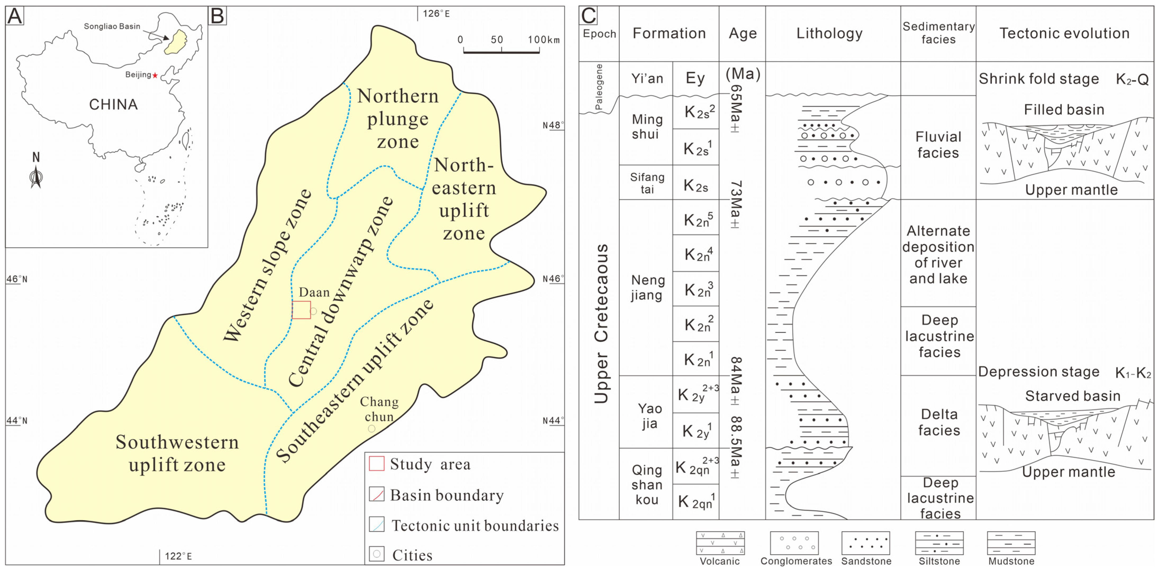
The Songliao Basin, located in northeastern China, is a Mesozoic–Cenozoic terrestrial large composite sedimentary basin characterized by a typical fault–depression dual structure. Since the Triassic period, the basin has undergone four evolutionary stages: uplift, faulting, depression, and shrinkage. From the Early Cretaceous Quantou Formation period, the basin entered the depression phase, forming secondary depressions such as Qijia-Gulong, Sanzhao, and Changling within the central depression zone. During the Quantou Formation’s third member, except for a few marginal uplifts such as the southwestern uplift of the western slope [36], sediments almost completely covered all uplifts within the basin, presenting a “one depression, two uplifts” paleogeographic morphology and forming a unified Songliao paleolake basin [37].
The Da’anbei area is located in the northern part of the Changling Depression in the central depression zone of the southern Songliao Basin, with a working area of about 440 km2 (Figure 1). During the Nenjiang Formation period, the study area was in the depression phase of the Songliao Basin, a critical period when the lake basin developed from prosperity to decline. Previous studies have shown that during the second member of the Nenjiang Formation, the area of the Songliao Lake Basin reached its maximum. Starting from the sedimentary period of the third member of the Nenjiang Formation [38], a large amount of water flowed out of the lake-sea channel, causing the lake water to continuously become shallower [39]. Sediments were continuously pushed toward the center of the lake basin by rivers, forming a lake regression-progradational shallow-water delta sedimentary sequence in the Nenjiang Formation [40,41]. The third and fourth members of the Nenjiang Formation, as the main oil-bearing layers in the southern part of the Songliao Basin, have good exploration prospects.
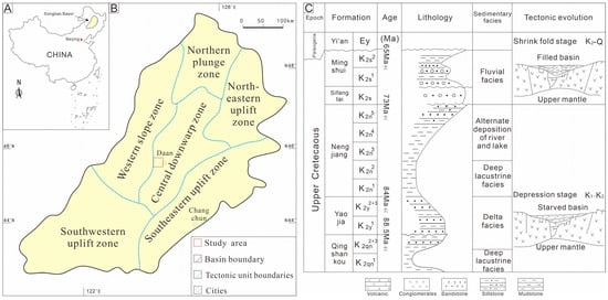
Figure 1.
(A) Location of the Songliao Basin in Northeastern China. (B) Simplified geological map of the central downwarp zone of the eastern Songliao Basin, showing the location of the study area. (C) General Early Cretaceous stratigraphy with the stratigraphic age of the Songliao Basin.
This study selected the Da’anbei Development Zone in the Honggang Terrace as the research object and used 493 logging data and 2D seismic data to divide the strata of all wells in the study area. Approximately 600 m of core data were recorded and collected from 12 selected core wells, which were evenly distributed within the study area. Approximately 2400 high-resolution core photos were taken to study lithofacies, sedimentary characteristics, and sedimentary evolution patterns at different periods. The heavy mineral content data of 12 core wells at different periods were organized and summarized to confirm the main types of heavy minerals in the study area and the characteristics of heavy mineral combinations at different periods. Finally, based on the analysis of the evolutionary characteristics and main controlling factors of sedimentary facies belts during the sedimentary period in the study area, combined with previous research data, a model for the evolution of the study area is established.
3. Sedimentary Characteristics of the Nenjiang Formation
3.1. Sedimentary Facies Markers
3.1.1. Rock Type
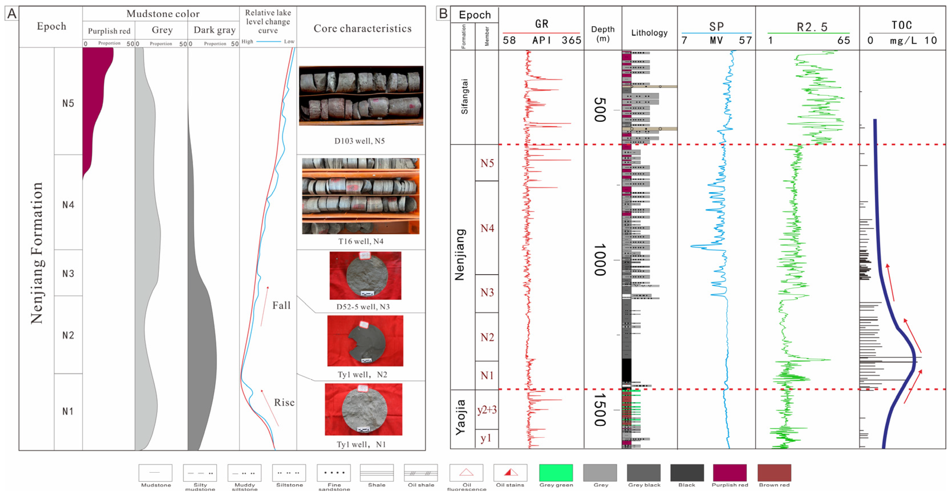
The Nenjiang Formation in the research area mainly develops two types of rock types: sandstone and mudstone. Sandstone is mainly composed of gray siltstone and gray argillaceous siltstone, with good grinding and sorting, and high structural maturity (Figure 2). Mudstones can be divided into three types based on their color. The Nen 1 Nen 2 section mainly develops dark gray gray-black mudstones and gray-black mudstones, indicating that the period was in a relatively deep water environment. The main development of gray mudstone and sandy mudstone is in the Nen 3 Nen 4 section, while a small amount of purple-red mudstone can be seen in the Nen 5 section, indicating that it was in an oxidizing environment during this period.
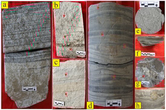
Figure 2.
Sedimentary structural characteristics of the Nenjiang Formation in the southern Da’anbei area of the Songliao Basin. (a): Grey siltstone, parallel bedding, D52-5 well, 966.7 m; (b): Grey siltstone with obvious scouring surface and parallel bedding, T16 well, 1100.5 m; (c): Gray siltstone, with lens-like bedding at the bottom, trough-like cross-bedding in the middle, and parallel bedding in the upper part. T16 well, 1101.59 m; (d): Muddy siltstone, bottom lenticular bedding, middle vein bedding, top flowing sand ripple bedding, D52-5 well, 974.95 m; (e): Dark gray mudstone with a large number of ostracoid fossils, H93 well, 1414.32 m; (f): Grey mudstone, horizontal bedding, HH112 well, 671.3 m; (g): Dark gray mudstone, calcite vein, Ty1 well, 1586.69 m; (h): Grey-green sandy mudstone with a small amount of pyrite clumps, D52-5 well, 971.5 m.
3.1.2. Sedimentary Structure
The research area has developed various sedimentary structures, which can be divided into the following three categories based on the strength of hydrodynamics: (1) Strong hydrodynamic conditions: parallel bedding (Figure 2a), cross-bedding (Figure 2b), and erosion surface (Figure 2c); (2) Alternation of hydrodynamic strength: flowing sand bedding (Figure 2d), wavy bedding (Figure 2d), and vein bedding (Figure 2d); (3) Weak hydrodynamic conditions: Biofossils (Figure 2e), horizontal bedding (Figure 2f), and special minerals (Figure 2g,h).
3.2. Types and Characteristics of Sedimentary Facies
3.2.1. Delta Plain
- (1)
- Distributary Channel
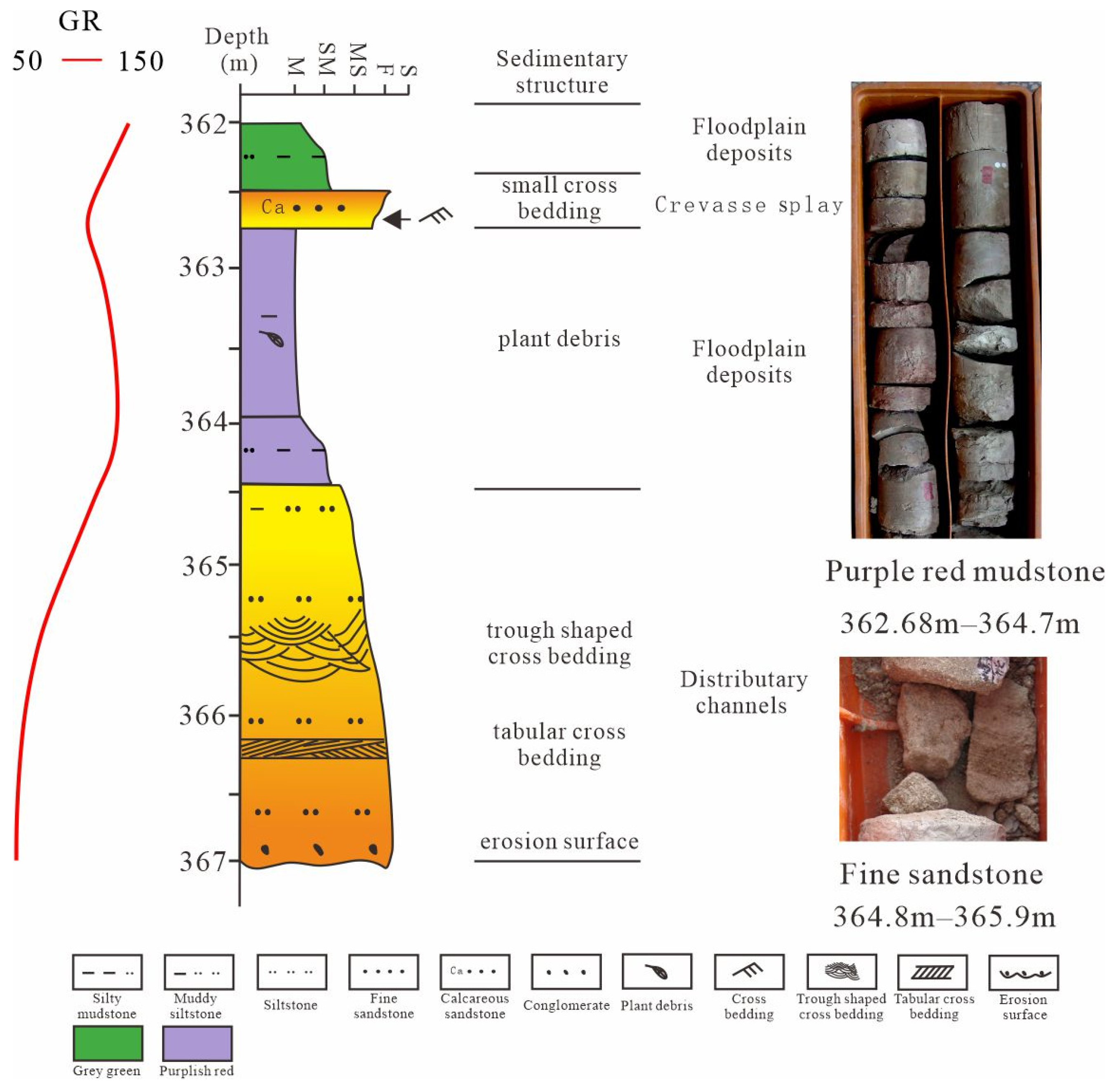
The lithology of the distributary channel sand body in the research area is mainly fine sandstone or siltstone, with a thickness usually between 2–4 m. Sedimentary structures such as medium-to-small trough-shaped cross-bedding and plate-shaped cross-bedding are commonly found in the sand bodies of the research area’s river channels. The GR curves of distributary channel sand bodies usually exhibit bell-shaped or box-shaped characteristics (Figure 3).
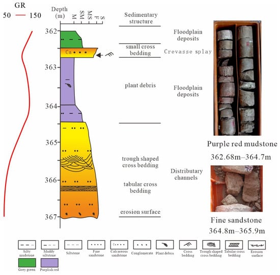
Figure 3.
Sedimentary characteristics of the Nenjiang Formation delta plain in the D103 well in the Da’anbei area.
- (2)
- Crevasse Splay
The crevasse fan is mainly composed of gray siltstone and muddy siltstone, with positive cyclic sedimentary characteristics. Small cross-bedding and sand grain bedding are developed in sandstone, with a thickness of 0.1–1 m. The microfacies of the crevasse fan are usually sandwiched in floodplain sediments, and the GR curves are characterized by finger-shaped or small bell-shaped features (Figure 3).
- (3)
- Floodplain Deposits
The flood sedimentary lithology is mainly composed of purple-red mudstone, grayish-green mudstone, or variegated mudstone, which is the most widely developed and thick sedimentary microfacies in the delta plain facies belt of the study area. A small amount of plant debris and biological fossils can be seen in the mudstone, and the GR curve corresponds to the characteristics of low amplitude and low toothed linearity (Figure 3).
3.2.2. Delta Front
- (1)
- Underwater distributary channels
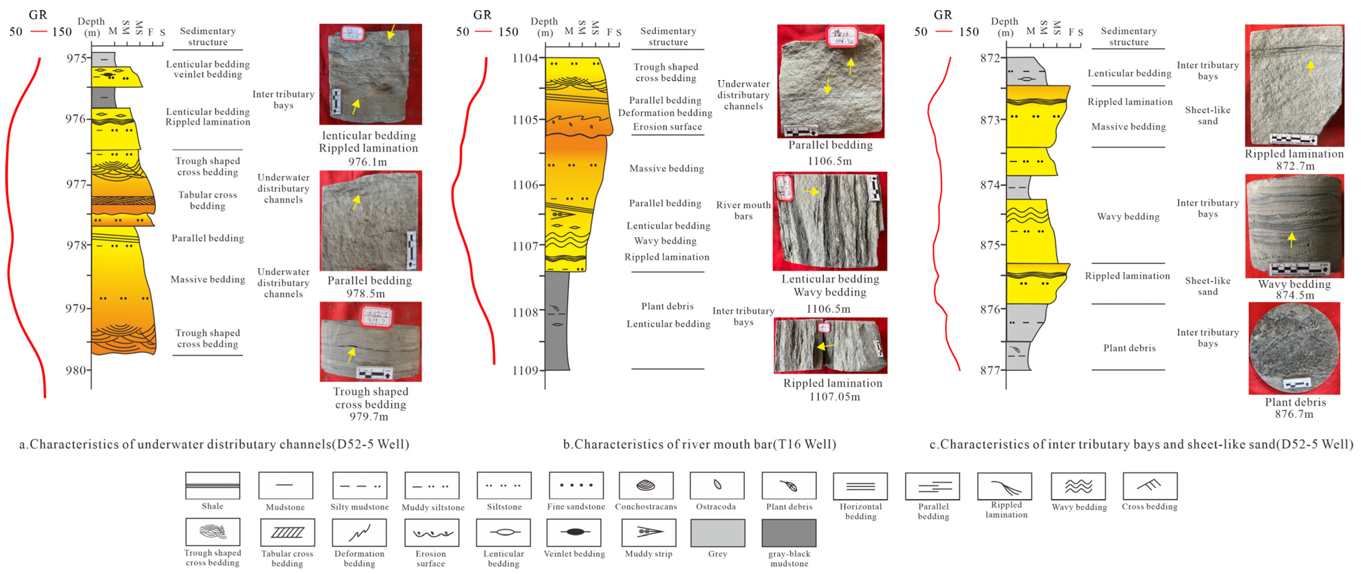
Underwater distributary channels are the extension of delta plain subfacies at the bottom of lakes, with similar positive rhythmicity, sedimentary structures, and logging curve characteristics to plain subfacies distributary channels. The microfacies lithology of underwater distributary channels in the research area is mainly composed of gray siltstone and muddy siltstone, with good sandstone sorting (Figure 4). Small-to-medium-sized cross-bedding or parallel-bedding sedimentary structures are mainly developed in sandstone, with obvious erosion surfaces at the bottom, characterized by the directional arrangement of mud and gravel in the sandstone (Figure 4a).
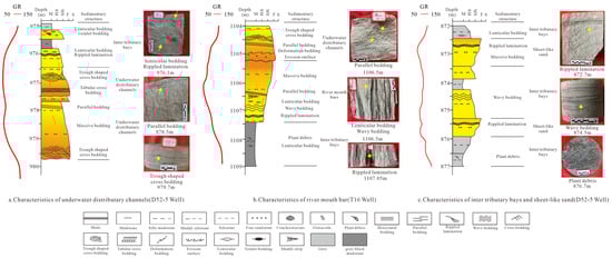
Figure 4.
Sedimentary microfacies characteristics of the delta front of the Nenjiang Formation in the Da’anbei area.
- (2)
- River Mouth Bars
On the logging curve, the sedimentary characteristics of the estuarine microfacies are usually funnel-shaped, mainly distributed on both sides of underwater distributary channels. The estuarine dam is subjected to river erosion and turbulence, causing the removal of muddy sediment and the preservation of sandy sediment. However, due to the relatively deep-water body of the lake basin in the study area and the relatively weak energy of the river channel, the muddy sediment cannot be completely removed. The lithology of the river mouth dam is mainly composed of muddy siltstone, with composite bedding such as veiny, wavy, and lens-shaped (Figure 4b).
- (3)
- Sheet-like Sands
Due to the overall gentle terrain of the research area, as the water depth of the lake basin continues to decrease and the energy of the river water body continues to strengthen, the previously formed estuary dam sand body undergoes a series of erosion, screening, and lateral migration processes, ultimately forming sheet-like or banded sedimentary bodies. On the GR curve, the sheet-like sand body presents a finger-shaped shape, with the lithology mainly composed of argillaceous siltstone and siltstone, exhibiting complex sedimentary structural characteristics such as wavy bedding, sand ripple bedding, and lens bedding. In the fifth section of the Nen section, the distribution of sheet-like sand microfacies is particularly significant, with a thickness generally ranging from 0.5 to 2 m (Figure 4c).
- (4)
- Interdistributary Bays
Interdistributary bays refers to a relatively low-lying area between underwater distributary channels, connected to an open lake surface. As the delta advances, a series of wedge-shaped mud deposits pointing towards the land are formed between the distributary channels. The sedimentation of the inter-tributary bay in the study area is mainly composed of mudstone, with a small amount of siltstone or muddy siltstone. Sandy sedimentation is the result of riverbed overflow sedimentation during flood season, usually appearing as interlayers or thin lenses of mudstone, with horizontal bedding, deformation bedding, and lens-like bedding, containing a large amount of plant debris or biological fossils. Interdistributary bays appear as toothed linear shapes on the GR curve (Figure 4c).
3.2.3. Lake Facies
- (1)
- Littoral Shallow Lake Deposits
The sedimentary characteristics of the shallow lake in the study area are mainly dark gray and grayish-black mudstones rich in biological fossils such as ostracods and leaf crustaceans (Figure 5a,b). In the early stage of the Nen section, some wells in the research area developed a small amount of lens-shaped thin-layer argillaceous siltstone sand bodies, with a thickness mostly less than 2 m. The logging showed finger-like characteristics similar to sheet-shaped sand bodies. This study identified them as microfacies of shore shallow lake sand bars. (Figure 5a). The well logs show a serrated linear pattern.
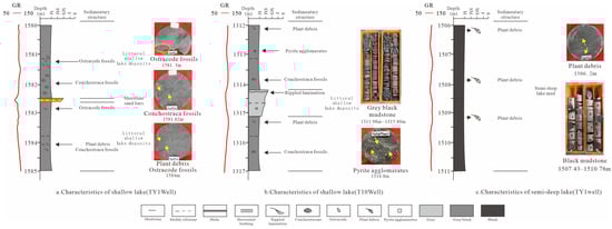
Figure 5.
Sedimentary microfacies characteristics of the Nenjiang Formation lake in the Taye 1 well in the Da’anbei area.
- (2)
- Semi-deep Lake Deposits
Deposits in the semi-deep lake zone mainly consist of gray-black mud shale, with parts showing clear lamination and abundant ostracod fossils and pyrite. The log response is characterized by a serrated linear pattern (Figure 5b).
4. Stratigraphic Division
4.1. Identification of Stratigraphic Interfaces
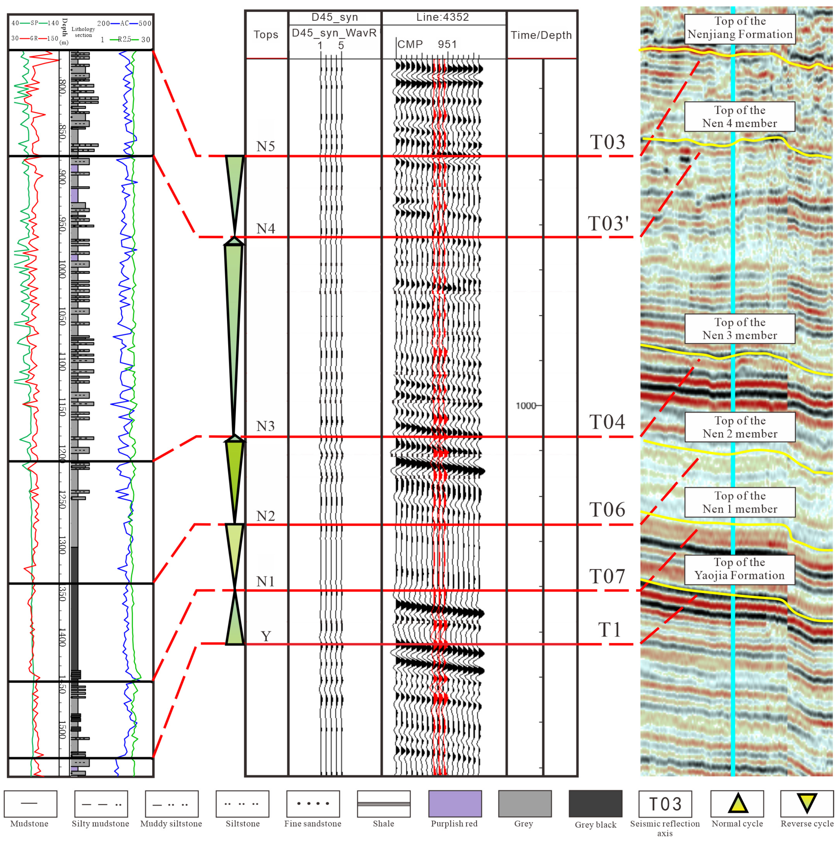
This paper identifies six stratigraphic boundaries in the Da’anbei area of the Nenjiang Formation through seismic stratigraphic calibration, rock–electric integration, and well–seismic integration techniques.
- (1)
- Sequence Boundary from Base-level Fall to Rise
- Scouring and erosion: Gravel at the base of river channel scour surfaces;
- Cyclical changes in sand-to-shale ratios: Below the interface, the grain size coarsens and the sand-to-shale ratio increases; above the interface, the grain size becomes finer and the sand-to-shale ratio decreases;
- Log signature: Electrical property discontinuities, with log curve patterns changing from regressive to transgressive sequence sets;
- Well–seismic calibration: Sequence boundaries generally correspond to troughs or the zero phase (Figure 6);
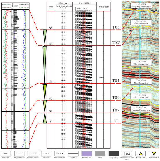 Figure 6. Seismic Layer Calibration to Determine Stratigraphic Interface.
 - Seismic reflection characteristics: Moderate-to-high continuity and moderate-to-weak amplitude seismic reflections, with the Nenjiang Formation, from bottom to top, corresponding to seismic reflectors T1, T07, T06, T04, T03′, and T03 (Figure 6).
- (2)
- Sequence Boundary from Base-level Rise to Fall (Lake Flooding Surface)
- Dark and varicolored mudstone segments;
- Facies change points;
- Locations of aggradational stacking pattern transitions;
- Log curve transitions from positive to negative cycles.
4.2. Stratigraphic Division and Characteristics
On the basis of identifying and comparing the baseline cycle interface, six third-level interfaces of the Nenjiang Formation in the northern Da’an area were determined. Their characteristics are: the bottom interface of the Nenjiang Formation is a lithological conversion interface, with dark mudstone above the interface and purple-red mudstone or sandstone below the interface, corresponding to the seismic strong reflection T1 axis; the bottom interface of the second section of the Nen Formation is a lithological mutation interface, with a stable distribution of oil shale in the entire area developed above the interface, corresponding to the weak seismic reflection T07 axis (Figure 6); the bottom interface of the third section of the tender section is an electrical conversion interface. Above the interface, R2.5 decreases, AC increases, and GR decreases, corresponding to the T06 axis of strong seismic reflection (Figure 6); the bottom interface of the fourth section of the Nen section is a secondary lake flooding surface, with a stable distribution of mudstone developed in the region, representing a rapid rise and slow decline of the lake level in the work area, corresponding to the T04 axis of strong seismic reflection (Figure 6); the bottom interface of the fifth section of the Nen section is a secondary lake flooding surface, with a stable distribution of mudstones developed in the region, representing a rapid rise and slow decline of the lake level in the work area, corresponding to the T03′ axis of strong seismic reflection (Figure 6); the top of the fifth section of the Nen section is a regional unconformity interface, which is overlaid by the unconformity contact of the Sifangtai Formation, corresponding to the strong seismic reflection T03 axis (Figure 6).
On this basis, a stratigraphic division plan for the Nenjiang Formation in the Da’anbei area is established, which divides the study interval into seven long-term baseline cycles (Figure 6): the descending long-term baseline cycle (Nen 2 and Nen 5) and the rising long-term baseline cycle (top of Nen 1, Nen 3, and Nen 4).
4.3. Stratigraphic Framework
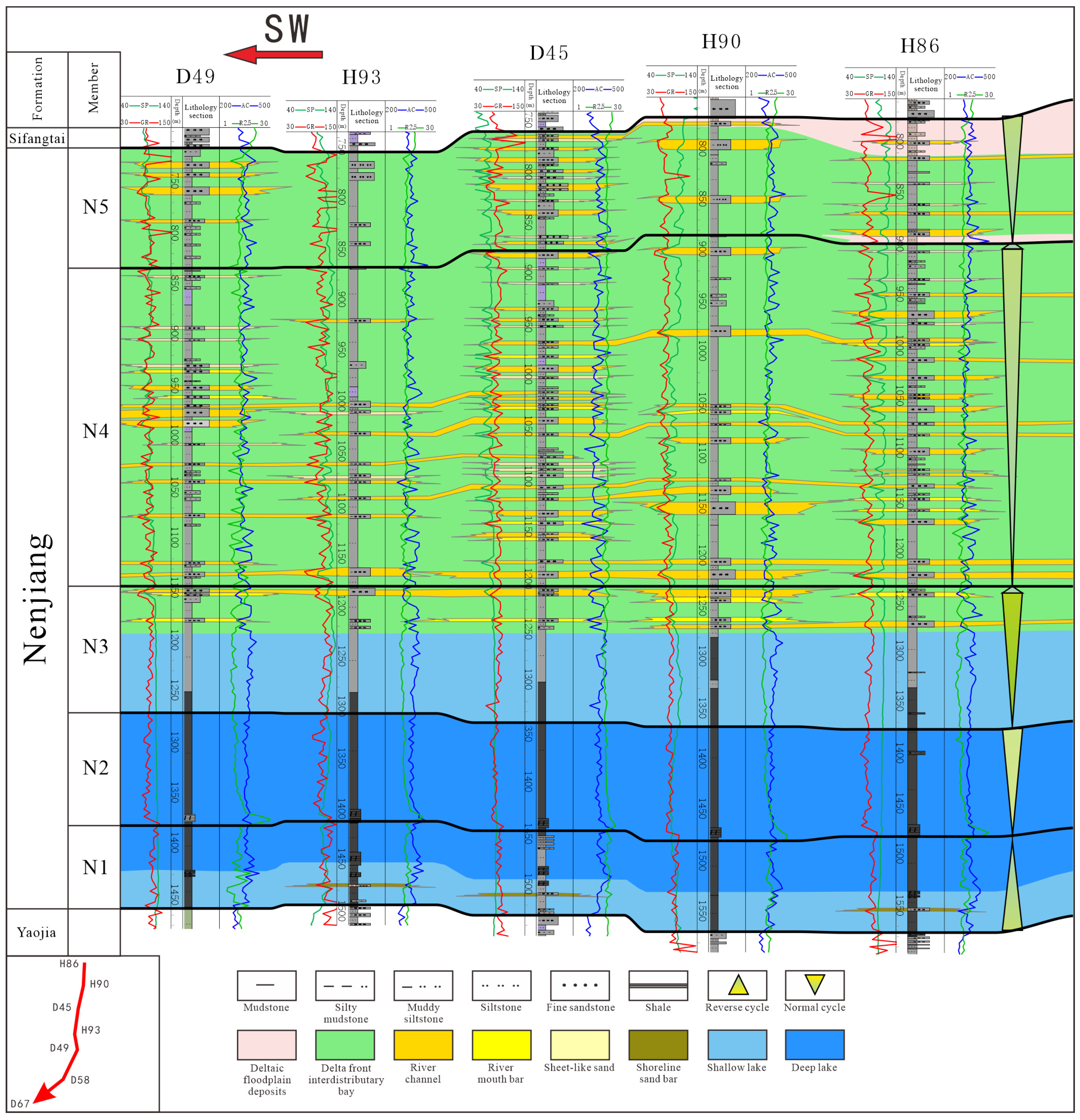
Utilizing sequence stratigraphy theory [42] combined with detailed core observations, high-resolution sequence analysis through multiple exploratory wells was conducted for sequence stratigraphic division and detailed correlation, establishing an isochronous sequence stratigraphic framework. This paper selects a cross-well section parallel to the provenance, characterized as follows:
The north–south oriented sequence profile (from Well Da49 to Hong86) aligns with the direction of the source material (Figure 7). In the northern part, closer to the source area, the strata are thicker, thinning slightly to the south. The overall study interval exhibits a complete cyclical sequence, with the falling half-cycle being more developed, clear top and bottom boundaries, and relatively consistent stratigraphic thickness. Each boundary shows good correspondence in both electrical properties and lithology.
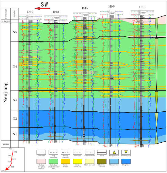
Figure 7.
Sequence Stratigraphic Framework of the Connection from Well D49 to Well Hong 86.
5. Distribution of Sedimentary Facies
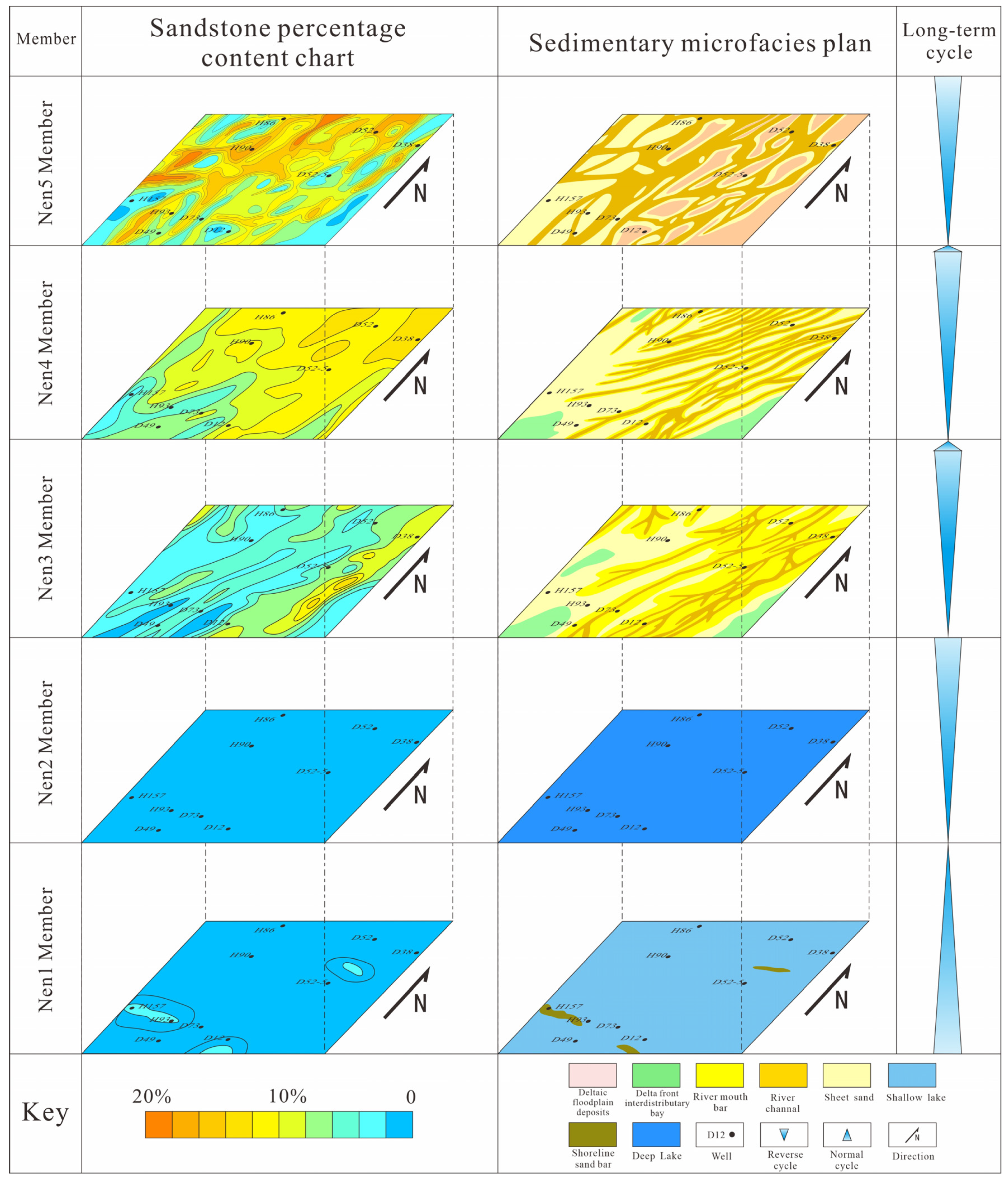
Based on the above research findings, combined with the sand body percentage maps of the Nen 1 to Nen 5 segments in the study area, well-to-well sedimentary facies maps for the Nen 1 to Nen 5 segments (Figure 8) and sedimentary facies planar distribution maps (Figure 8) were drawn. This aids in further analyzing the sedimentary environment, sand body development characteristics, and paleogeographic patterns.

Figure 8.
Distribution of sedimentary facies in the Nenjiang Formation of the Da’anbei area.
The sequences from Nen 1 to Nen 5 represent a complete regional cycle of lake transgression and regression, with each sequence significantly influenced by lake level changes. The Nen 1 to Nen 2 period was a time of continuous lake expansion, a regressive process that reached its peak at the base of the Nen 2 segment during the Cretaceous lake deposits of the Songliao Basin (Figure 8).
Entering the Nen 3 period, the lake level began to shrink consistently. With the northeastern provenance beginning to supply material, the study area transitioned from littoral shallow lake deposits to delta front deposits. The delta front sand bodies spread from the northeast to the southwest, with underwater distributary channels exhibiting a branched distribution. On either side of these channels, river mouth bar microfacies developed, as well as contiguous sheet sand microfacies reworked by lake waters, forming the embryonic stage of the Nenjiang Group delta (Figure 8).
The Nen 4 depositional period inherited the sedimentary pattern of the basin depression from the Nen 3 segment, predominantly characterized by delta front deposits. During the Nen 4 period, influenced continuously by the northeastern provenance, the channel sand bodies showed strong progradation, with an increase in the number and scale of channels compared to the Nen 3 segment. Underwater distributary channels extended to the central lake basin, causing the terminal river mouth bars to be reworked and sorted by lake waves and shore currents, forming extensive areas of sheet sand microfacies (Figure 8).
During the Nen 5 period, the lake drastically shrank, with the A/S ratio (the ratio of the rate of increase in accommodating space to the rate of sediment supply) reaching its lowest. The main body of the study area was still dominated by delta front deposits, but due to the shallow water, river mouth bars gradually ceased to develop, and the sand bodies advanced forward with a combination of underwater distributary channels and sheet sands. Near the source area, many interdistributary bay deposits could be seen. In the area east of Hong86–Hong90–Da55, delta plain deposits began to appear, developing distributary channels, floodplain deposits, and interchannel sand microfacies (Figure 8).
6. Sedimentary Evolution Control Factors
The distribution of sedimentary facies in continental shallow-water deltas is influenced by factors such as paleoclimate, relative lake level changes, and the intensity of provenance supply. Relative lake level changes determine the available accommodation space [43], while paleoclimate and provenance supply intensity dictate the quantity of sediment supplied [44].
6.1. Control of Lake Level Changes on Sedimentary Systems
Lake level fluctuations determine the accommodation space, rate of change, and distribution range of the source area, thus limiting sediment supply, affecting the formation and distribution of sedimentary systems and influencing the distribution of reservoir sand bodies. The Cretaceous Nenjiang Formation of the Songliao Basin in southern areas marks the second flourishing period of the Songliao lake basin, as well as its gradual decline. By analyzing the percentage content of purple-red, gray, and grayish-black mudstones from multiple core wells in the study area (Figure 9), the changes in the lake level in the study area are indicated by the vertical changes in mudstone content. The relative lake level of the Nenjiang Formation generally shows an initial rise followed by a continuous decline, with multiple phases of rise and fall within each sequence. During the Nen I period, the lake level primarily showed a rising trend, reaching the peak of the Cretaceous lake basin by the Nen II period, with oil shale at the base of Nen II marking the formation of the maximum lake transgression. As the lake level began to fall during the Nen III period, deltaic system sand bodies started to prograde into the lake, although the extent of deltaic system development was limited. Due to the continuous decline in lake level and the ongoing progradation of the northern deltaic systems, by the Nen IV depositional period, lacustrine deposits were largely absent in the study area, and due to shallower water, river mouth bars gradually ceased to develop. By the Nen V period, the lake had drastically shrunk, the ratio of accommodation space to sedimentation rate reached its lowest point, and the scale of sand bodies gradually increased, beginning the transition from the delta front system to the delta plain system.
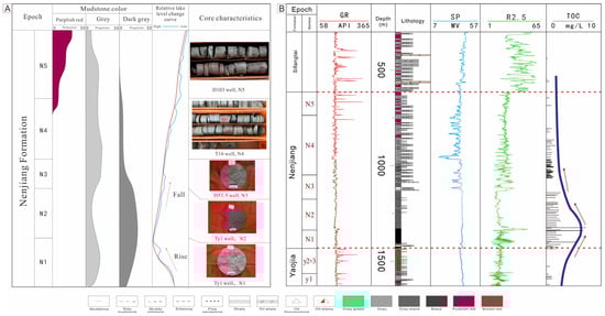
Figure 9.
(A) Relative Lake Level Changes and Mudstone Characteristics. (B) TOC content variation chart of the T16 well.
6.2. Control of Provenance Supply on Sand Body Distribution
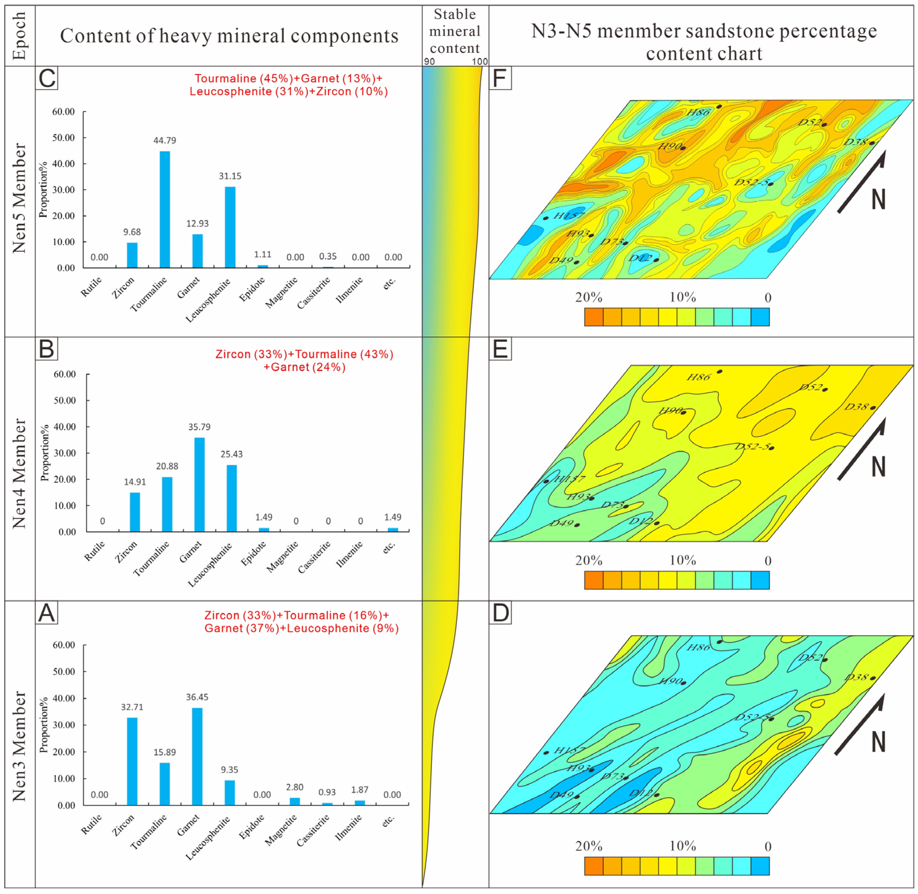
Samples were taken from 12 core wells in the research area, with an interval of 10 cm between each sample. Among them, there were a total of four samples from the Nen5 section, 22 samples from the Nen4 section, and 30 samples from the Nen3 section. Using a microscope to observe the samples and determine the type of heavy mineral, the point counting method was used to calculate the content of each mineral. Due to the small number of samples in the fifth section of the Nen section in the study area, Q-type or R-type clustering analysis cannot be used for more accurate quantitative research. However, the variation pattern of the heavy mineral composition can still be observed based on its combination. The ZTR index was first proposed by Hubert [45] and refers to the proportion of zircon, tourmaline, and rutile in transparent minerals. It is mainly used to distinguish the maturity of clastic rock components. The larger the ZTR index, the higher its maturity. The maturity of minerals is influenced by various factors such as transport distance, diagenesis, and ancient structures. Systematic research can be used to indicate sedimentary transport distance and source direction [46].
In response to the material source problem of the Nenjiang Formation in the southern part of the Songliao Basin, an analysis was conducted on the types and contents of heavy mineral combinations in some core wells in the study area (Figure 10). After sorting and analyzing the heavy mineral data in the study area, it was found that the ZTR values gradually increased along the NE–SW direction, indicating that the source direction is northeast. The heavy mineral combination transitions from a combination of garnet (37%), zircon (33%), tourmaline (16%), and perovskite (9%) in the Nen 3 member (Figure 10A) to a combination of tourmaline (43%), zircon (33%), and garnet (24%) in the Nen 4 member (Figure 10B), and finally to tourmaline (45%), garnet (13%), perovskite (31%), and zircon (10%) in the Nen 5 member (Figure 10C). The content of stable heavy minerals in the longitudinal direction gradually increased from 89% in the third segment to 95% in the fifth segment (Figure 10). Based on the sand ratio map and sedimentary facies map of the Nen 3 to Nen 5 sections, it can be concluded that from the Nen 3 section onwards, due to the continuous supply of northern sediment sources, the delta front sediment gradually dominated (Figure 10D). However, with the further strengthening of river channel energy, the previously formed estuarine bar sand body was washed away, forming large areas of thin layered sand bodies on both sides and at the end of the river channel (Figure 10E). This continued until the Nen 5 section, and the estuarine bar sand body no longer developed in the study area (Figure 10F).

Figure 10.
Heavy mineral content map of the Nenjiang Formation in the study area. (A) The content of each component of heavy minerals in the Nen 3 Member; (B) The content of each component of heavy minerals in the Nen 4 Member; (C) The content of each component of heavy minerals in the Nen 5 Member; (D) Sand ratio map of Nen 3 Member; (E) Sand ratio map of Nen 4 Member; (F) Sand ratio map of Nen 5 Member.
6.3. Control of Paleoclimate on Sedimentary Evolution
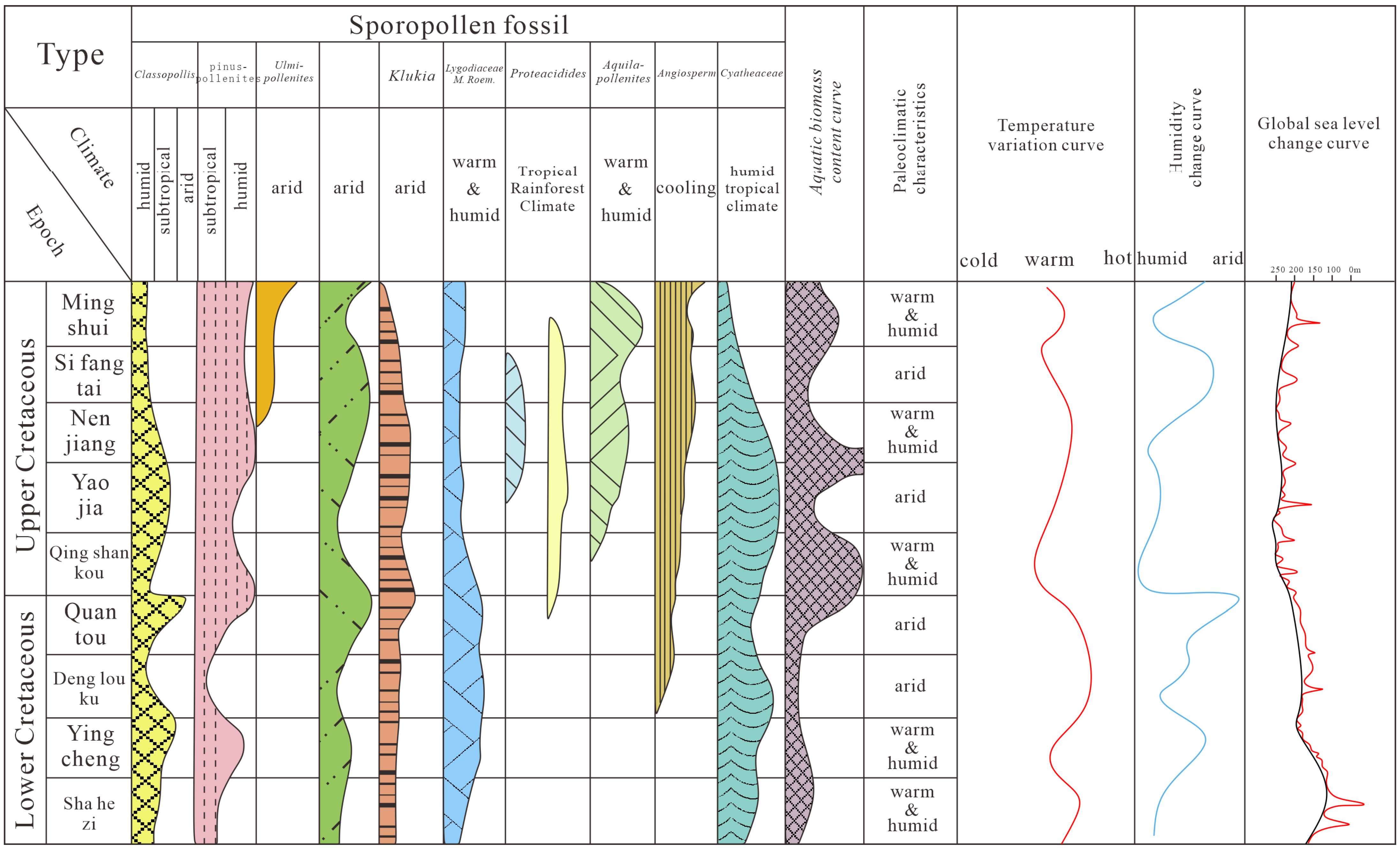
In addition to developing abundant terrestrial plant and spore fossils, the Cretaceous Nenjiang Formation of the Songliao Basin also has rich aquatic biological fossils, mainly including dinoflagellates, ostracods, and phyllopods [47]. The spore assemblages are dominated by angiosperm pollen, including mainly Beaupreaidites and Gothanipollis [48]. The spore assemblages with the highest content are pinuspollenites and Aquilapollenites. These fossil assemblages suggest that during the deposition of the Nenjiang Formation, the paleoclimate was generally warm and humid or transitioning from warm and humid to hot and dry (Figure 11).
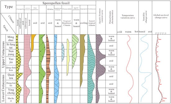
Figure 11.
Paleontological and paleoclimate change map of the Nenjiang Formation in the study area (revised according to reference [44]).
During the early Nenjiang Formation, under warm and humid climatic conditions, physical and chemical weathering in the source area was not intense. The study area’s delta front extended far and developed a wide range, gradually forming the embryonic delta. Vertically, as humidity gradually decreased and temperature slowly rose, physical weathering in the source area became more intense, transporting large amounts of clastic material to the area and rapidly expanding the delta plain area (Figure 11).
7. Sedimentary Evolution Models
During the depositional period of the Nenjiang Formation, the study area was in a stable subsidence stage of the Songliao Basin, with a large lake basin area, shallow water, flat terrain, frequent lake level fluctuations, and a wide area of wave action with relatively weak energy, providing conditions suitable for forming shallow-water deltaic sedimentary systems. Based on core observations, drilling, planar sedimentary facies evolution analysis, and sand body development characteristics, a shallow-water delta sedimentary model for the southern Nenjiang Formation was established.
During the early stage of the Nen 1 period, influenced by sediment supply from the northeastern part of the southern Songliao Basin, a few shore-shallow lake sand bar microfacies developed in the central and northeastern parts of the study area. By the end of the Nen 1 period, as the water body deepened further, lacustrine deposits predominantly developed across the area, with virtually no sandy deposits forming (Figure 12A). The lake level during the Nen 1 period continued to rise, reaching its peak at the base of the Nen 2 period in the Songliao Lake Basin. It was not until the beginning of the Nen 2 period that the lake level started to decline gradually (Figure 12B). During the Nen 3 and Nen 4 depositional periods, delta front channels and river mouth bars coexisted, with frequent bifurcations and wide extensions, forming the framework of the delta front. Sheet sand deposits developed only on the outer side of the delta front, with many inter-distributary bay deposits visible on the inner side due to shallow water. Delta plain channels and river mouth bars were larger, with relatively pure mudstone. From bottom to top, a progradational depositional sequence with gradually increasing sand body size was formed (Figure 13A).
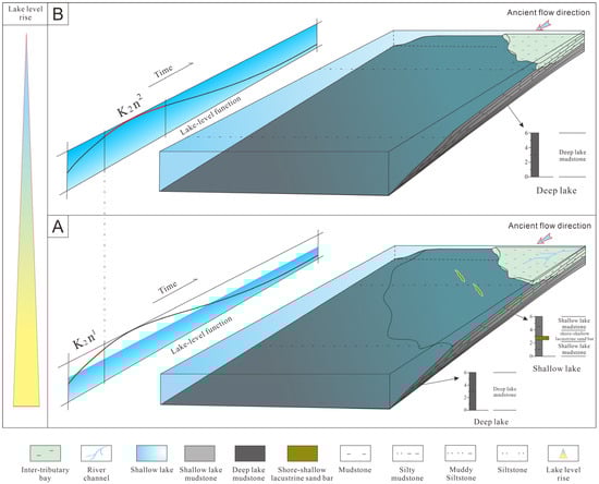
Figure 12.
(A) Sedimentary Model of the Nen 1 Member in the Study Area. (B) Sedimentary Model of the Nen 2 Member in the Study Area.
Figure 13.
(A) Sedimentary Model of the Nen 3 and Nen 4 Members in the Study Area. (B) Sedimentary Model of the Nen 5 Member in the Study Area.
During the Nen 5 depositional period, influenced by lake level fluctuations and decline, the channels under this depositional model continuously changed courses and bifurcated, continuing to prograde forward. During this period, the water depth was shallower than during the Nen 3 period, river mouth bars gradually ceased to develop, and sand bodies advanced with a combination of underwater distributary channels and sheet sands. From bottom to top, a progradational depositional sequence with a transition from reduced to oxidized sediment colors, gradually increasing sand body size, and progressively more plain sediments was formed (Figure 13B).
Overall, the Nenjiang Formation represents a sedimentary process of regression followed by progradation, with sand thickness and sand-to-shale ratio first decreasing and then continuously increasing, reflecting a process of continuous and strengthening provenance supply, and corresponding increasing fan body size. From the late Nen II period onwards, as the lake basin continuously shrank, the delta continuously prograded forward.
8. Conclusions
- (1)
- In the southern part of the Songliao Basin, Da’anbei area, the Nenjiang Formation primarily exhibits two types of sedimentary facies: shallow-water delta and lake. These can be further divided into four subfacies and nine microfacies. Chronologically, the Nen I segment predominantly features littoral shallow lake deposits and the Nen II segment mainly develops semi-deep lake deposits. As the lake level continuously declined, starting from the Nen III segment, delta front deposits began to develop and gradually took a dominant position, eventually transitioning to delta plain deposits by the Nen V segment.
- (2)
- Based on core observations, drilling, and analysis of planar sedimentary facies evolution and sand body development characteristics, two sedimentary models for the shallow-water delta of the southern Nenjiang Group have been established. In a deeper water context, the channel-river mouth bar sequence forms the progradational depositional sequence of the delta front framework. In a shallower water context, the channel-sheet sand sequence forms the delta front framework and gradually transitions to a progradational depositional sequence, moving into delta plain deposits.
- (3)
- The development of the shallow-water delta sedimentary system in the Nenjiang Formation of the study area is primarily influenced by relative lake level, provenance, and paleoclimate. Changes in climatic conditions, the continuous decline of the lake level, and the persistent supply from the northeastern provenance are the main factors contributing to the development of the progradational shallow-water delta in the study area.
Author Contributions
Writing-original draft, L.Y. and M.H.; Analysis, Validation, Data Processing, L.Y.; Investigation, Conceptualization, Supervision, Review, M.H. and Q.D. All authors have read and agreed to the published version of the manuscript.
Funding
Supported by the National Natural Science Foundation of China project (42202161) “Response relationship between sedimentary configuration and basin bottom slope of underwater distributary channels in shallow delta front of lake basins”.
Institutional Review Board Statement
Not applicable.
Informed Consent Statement
Not applicable.
Data Availability Statement
All data and materials are available on request from the corresponding author. The data are not publicly available due to ongoing research using a part of the data.
Conflicts of Interest
The authors declare no conflict of interest.
References
- Shen, A.J.; Wang, Y.Q.; Lu, J.M.; Geng, Z.X.; Ru, G.R. Exploration theory and practice of lithological stratigraphic oil and gas reservoirs in the southern Songliao Basin. China Pet. Explor. 2004, 9, 40–44+71,72. [Google Scholar]
- Xiu, L.J.; Li, G.X.; Jian, O.; Weiwei, W. Distribution Law and Exploration Potential of Low-resistivity Reservoirs in the South of Songliao Basin. China Pet. Explor. 2006, 11, 7. [Google Scholar]
- Wang, H.W. Exploration practice of lithological oil reservoirs in the Heidi Temple oil layer of Changling Depression. Spec. Oil Gas Reserv. 2015, 22, 59. [Google Scholar]
- Postma, G. An analysis of the variation in delta architecture. Terra Nova 1990, 2, 124–130. [Google Scholar] [CrossRef]
- Reynolds, A.D. Variability in fluvially-dominated, fine-grained, shallow-water deltas. Sedimentology 2022, 69, 2779–2813. [Google Scholar] [CrossRef]
- Wang, M.Q.; Xie, J.; Zhang, Q.; Wang, Y.J.; Duan, Y.J. Characteristics and sedimentary model of a reticular shallow-water delta with distributary channels: Lower member of the Neogene Minghuazhen Formation in the Bozhong area of the Huanghekou Sag, China. Arab. J. Geosci. 2019, 12, 760. [Google Scholar] [CrossRef]
- Huang, X.; Liu, K.; Zou, C.; Yuan, X.; Gui, L. Forward stratigraphic modelling of the shallow-water delta system in the Poyang Lake, southern China. J. Geochem. Explor. 2014, 144, 74–83. [Google Scholar] [CrossRef]
- Liu, Z.; Shen, F.; Zhu, X.; Li, F.; Tan, M. Formation conditions and sedimentary characteristics of a Triassic shallow water braided delta in the Yanchang Formation, Southwest Ordos Basin, China. PLoS ONE 2015, 10, e0119704. [Google Scholar] [CrossRef] [PubMed]
- Geleynse, N.; Storms, J.E.; Walstra DJ, R.; Jagers, H.A.; Wang, Z.B.; Stive, M.J. Controls on river delta formation; insights from numerical modelling. Earth Planet. Sci. Lett. 2011, 302, 217–226. [Google Scholar] [CrossRef]
- Chen, C.; Zhu, Y.; Lei, Z.; Li, S.; Jiang, Y. Flume experiment study of the formation process and sedimentary characteristics of a shallow-water delta. Geol. J. 2023, 58, 837–848. [Google Scholar] [CrossRef]
- García-García, F.; Corbí, H.; Soria, J.M.; Viseras, C. Architecture analysis of a river flood-dominated delta during an overall sea-level rise (early Pliocene, SE Spain). Sediment. Geol. 2011, 237, 102–113. [Google Scholar] [CrossRef]
- Hao, S.; Liu, H.; Du, X.; Niu, C. Sedimentary characteristics of shallow-water delta and responses features in palaeoenvironment: A case study from the lower part of Neogene Minghuazhen Formation (Bonan area, Bohai Bay Basin, E China). Arab. J. Geosci. 2021, 14, 1–20. [Google Scholar] [CrossRef]
- Tian, L.X.; Liu, H.; Niu, C.M.; Du, X.F.; Yang, B.; Lan, X.D.; Chen, D.L. Development characteristics and controlling factor analysis of the Neogene Minghuazhen Formation shallow water delta in Huanghekou area, Bohai offshore basin. J. Palaeogeogr. 2019, 8, 1–19. [Google Scholar] [CrossRef]
- Cai, Q.S.; Hu, M.Y.; Liu, Y.N.; Kane, O.I.; Deng, Q.J.; Hu, Z.G.; Li, H.; Ngia, N.R. Sedimentary characteristics and implications for hydrocarbon exploration in a retrograding shallow-water delta: An example from the fourth member of the Cretaceous Quantou Formation in the Sanzhao depression, Songliao Basin, NE China. Pet. Sci. 2022, 19, 929–948. [Google Scholar] [CrossRef]
- Zhang, Y.; Bao, Z.; Dou, L.; Jiang, L.; Wei, M.; Zhang, L. Hydrodynamics and deposition in lacustrine shallow-water delta front: A combination of numerical simulations and modern sedimentation measurements. Interpretation 2020, 8, SM39–SM52. [Google Scholar] [CrossRef]
- Xu, Z.H.; Wu, S.H.; Liu, Z.; Zhao, J.S.; Geng, H.L.; Wu, J.C.; Zhang, T.Y.; Liu, Z.W. Sandbody architecture of the bar finger within shoal water delta front: Insights from the lower member of Minghuazhen Formation, Neogene, Bohai BZ25 oilfield, Bohai Bay Basin, East China. Pet. Explor. Dev. 2019, 46, 335–346. [Google Scholar] [CrossRef]
- Zhu, X.; Zeng, H.; Li, S.; Dong, Y.; Zhu, S.; Zhao, D.; Huang, W. Sedimentary characteristics and seismic geomorphologic responses of a shallow-water delta in the Qingshankou Formation from the Songliao Basin, China. Mar. Pet. Geol. 2017, 79, 131–148. [Google Scholar] [CrossRef]
- Xu, Z.H.; Plink-Björklund, P.; Wu, S.H.; Liu, Z.; Feng, W.J.; Zhang, K.; Yang, Z.; Zhong, Y. Sinuous bar fingers of digitate shallow-water deltas: Insights into their formative processes and deposits from integrating morphological and sedimentological studies with mathematical modelling. Sedimentology 2022, 69, 724–749. [Google Scholar] [CrossRef]
- Li, J.P.; Liu, H.; Niu, C.M.; Guo, R.B.; Wang, Y. Evolution regularity of the Neogene shallow water delta in the Laibei area Bohai Bay Basin, northern China. J. Palaeogeogr. 2014, 3, 257–269. [Google Scholar]
- Tong, Q.; Jiao, T.; Qi, Z.; Wang, H.; Liu, Y.; Zhu, Y.; Liu, H. Spatiotemporal evolution of single sandbodies controlled by allocyclicity and autocyclicity in the shallow-water braided river delta front of an open lacustrine basin. Open Geosci. 2021, 13, 98–121. [Google Scholar] [CrossRef]
- Zhang, X.; Wu, D.; Fu, M.; Deng, H.; Xu, Z.; Chen, C. Controls of sandstone architecture on hydrocarbon accumulation in a shallow-water delta from the Jurassic Shaximiao Formation of the western Sichuan Basin in China. Energy Rep. 2022, 8, 6068–6085. [Google Scholar] [CrossRef]
- Olariu, C.; Bhattacharya, J.P. Terminal distributary channels and delta front architecture of river-dominated delta systems. J. Sediment. Res. 2006, 76, 212–233. [Google Scholar] [CrossRef]
- Gani, M.R.; Bhattacharya, J.P. Basic building blocks and process variability of a Cretaceous delta: Internal facies architecture reveals a more dynamic interaction of river, wave, and tidal processes than is indicated by external shape. J. Sediment. Res. 2007, 77, 284–302. [Google Scholar] [CrossRef]
- Zhang, C.M.; Yin, T.J.; Zhu, Y.J.; Ke, L.M. Shallow water delta sedimentary model. J. Sedimentol. 2010, 5, 933–944. [Google Scholar]
- Li, S.M.; Song, X.M.; Liu, Y.Q.; Wang, Y.Q.; Li, Y.M.; Tang, H.J. Sedimentary models of Wenmi retreat type and progradation type shallow water braided river delta. J. Jilin Univ. (Earth Sci. Ed.) 2011, 3, 665–672. [Google Scholar]
- Zhu, Y.J.; Zhang, C.M.; Yin, T.J. Sedimentary characteristics and simulation of stacked shallow water delta. Geol. Sci. Technol. Inf. 2013, 3, 59–65. [Google Scholar]
- Yin, T.J.; Zhang, C.M.; Zhu, Y.J.; Yang, W.; Ye, J.G.; Cai, W.; Dai, Y.Y. Overlapping delta - a special type of shallow water delta. J. Geol. 2014, 2, 263–272. [Google Scholar]
- Liu, Z.L.; Shen, F.; Zhu, X.M.; Liao, J.J.; Zhang, X.Q.; Meng, H. Progress in shallow water delta research and case analysis of terrestrial lake basins. Geol. Oil Gas 2015, 36, 596–604. [Google Scholar]
- Qi, Y.; Wang, Y.; Qin, G.; Song, Y.; Zhang, H.; Meng, F. Sedimentary evolutionary processes, architecture, and sedimentary model of a lobate shallow-water delta: Insights from flume simulation experiments. Front. Earth Sci. 2024, 12, 1393211. [Google Scholar] [CrossRef]
- Wu, S.H.; Xu, Z.H.; Liu, Z. Sedimentary configuration of river controlled shallow water delta. J. Paleogeography 2019, 2, 202–215. [Google Scholar]
- Zhang, P.; Qian, Q.H.; Jiang, M.Z.; Chen, X.Q.; Wang, A.M.; Chai, X.; Song, Z.Y.; Feng, W.J. Sedimentary characteristics and sedimentary models of shallow water deltas on the edge of arid lake basins: Taking the VI oil formation of the Lower Oil Sand Mountain Formation in the Gaskule Oilfield, Qinghai Province as an example. J. Sedimentol. 2023, 41, 839–854. [Google Scholar]
- Ren, D.W.; Wei, S.Y.; Yin, T.J.; Chen, S.W.; Fang, J.S.; Zhao, W.K. Response process of finger shaped sand bar type shallow water delta sedimentation under the background of lake level changes: Based on flume sedimentation simulation experiments. Modern Geol. 2024. [Google Scholar] [CrossRef]
- Zhang, L.; Bao, Z.D.; Lin, Y.B.; Chen, Y.M.; Lin, X.H.; Dou, L.X.; Kong, B. Genetic types and sedimentary model of sandbodies in a shallow-water delta: A case study of the first Member of Cretaceous Yaojia Formation in Qian’an area, south of Songliao Basin, NE China. Pet. Explor. Dev. 2017, 44, 770–779. [Google Scholar] [CrossRef]
- Li, M.; Chen, B.; Ruan, J.F.; Bao, Z.D.; Zeng, D.S.; Zheng, J.H.; Xiao, H.Z.; Shi, J.M. Spatial Development Characteristics of Shallow Water Delta Skeleton Single Sand Body in Quansi Member of Lower Cretaceous in Xinmin Oilfield, Songliao Basin. Marine Geol. Quat. Geol. 2019, 39, 46–55. [Google Scholar]
- Fu, C.; Yu, X.H.; Li, S.L.; Li, S.L.; Gao, M.X.; Peng, Z.X.; Zhao, H.Q. Response of lacustrine sequence styles and delta morphology under the background of differential accommodation space: A comparative study of Poyang Lake and Daihai Lake. J. Paleogeography 2022, 24, 1084–1098. [Google Scholar]
- Li, J.; Shu, L.S. Structural characteristics and evolution of the Mesozoic and Cenozoic in the Songliao Basin. J. Nanjing Univ. (Nat. Sci. Ed.) 2002, 38, 525–531. [Google Scholar]
- Liu, Z.J.; Wang, D.P.; Liu, L.; Liu, W.Z.; Wang, P.J.; Du, X.D.; Yang, G. Sedimentary characteristics of the Cretaceous period in the Songliao Basin. J. Geol. 1992, 6, 327–338. [Google Scholar]
- Yuan, X.J.; Zhou, H.Y.; Zhang, Z.J.; Wang, Z.Y.; Cheng, D.W.; Guo, H.; Zhang, Y.Y.; Dong, W.T. Sedimentary characteristics and growth patterns of large shallow water deltas in depressed lake basins. Lithol. Oil Gas Reserv. 2021, 33, 1–11+281. [Google Scholar]
- Mo, W.L.; Wu, C.D.; Zhang, S. Formation mechanism of large delta front deposits in the continental depression lake basin of the second and third members of the Nenjiang Formation in the Songliao Basin. J. Pet. Nat. Gas 2012, 34, 1–6+164. [Google Scholar]
- Sun, Z.X.; Zhang, Y.N.; Liu, C.L.; Li, M.G. Sedimentary characteristics of shallow water deltas and their significance for oil and gas exploration. J. Pet. Nat. Gas 2012, 34, 161–165+3. [Google Scholar]
- Yang, H.; Hu, M.Y.; Cai, M.; Wang, D.; Cai, Q.S. Sedimentary characteristics and development models of the Nen 3 and 4 progradational shallow water delta in the Daqingzijing area of the southern Songliao Basin. Daqing Pet. Geol. Dev. 2022, 41, 1–10. [Google Scholar]
- Cross, T.A. Controls on Coal Distribution in Transgressive-Regressive Cycles, Upper Cretaceous, Western Interior, USA. Spec. Publ. Soc. Econ. Paleont. Miner. 1988, 42, 371–380. [Google Scholar]
- Wang, S.M.; Liu, Z.J. Analysis and application of changes in baseline and tolerable space. World Geol. 2001, 20, 1–7. [Google Scholar]
- Zhu, X.M.; Liu, Y.; Fang, Q.; Li, Y.; Liu, Y.Y.; Wang, R.; Song, J.; Liu, S.Q.; Cao, H.T.; Liu, X.N. Formation conditions and sedimentary models of shallow water deltas in large depression lake basins: Taking the Fuyu oil layer in the Sanzhao depression of the Songliao Basin as an example. Front. Geosci. 2012, 19, 89–99. [Google Scholar]
- Hubert, J.F. A Zircon-Tourmaline-Rutile Maturity Index and the Interdependence of the Composition of Heavy Mineral Assemblages with the Gross Composition and Texture of Sandstones. J. Sediment. Res. 1962, 32, 440–450. [Google Scholar]
- Yang, R.C.; Li, J.B.; Fan, A.P.; Zong, M.; Zhang, T. Research progress and development trends in source analysis of terrestrial sedimentary rocks. Pet. Geol. Exp. 2013, 31, 99–107. [Google Scholar]
- Zhang, S. Debate on the Late Cretaceous “Marine Invasion” Event in the Songliao Basin and Suggestions for Solution. Daqing Pet. Geol. Dev. 2021, 40, 1–12. [Google Scholar]
- Tian, M.; Zhang, M.S.; Ren, Y.G.; Qiao, X.Y.; Wan, C.B.; Liu, P.J. Spore pollen algae assemblages and their environment in the third section of the Nenjiang Formation in the Xinzhan area of the Songliao Basin. J. Jilin Univ. (Earth Sci. Ed.) 2005, 35, 449–455. [Google Scholar]


Disclaimer/Publisher’s Note: The statements, opinions and data contained in all publications are solely those of the individual author(s) and contributor(s) and not of MDPI and/or the editor(s). MDPI and/or the editor(s) disclaim responsibility for any injury to people or property resulting from any ideas, methods, instructions or products referred to in the content. |
© 2024 by the authors. Licensee MDPI, Basel, Switzerland. This article is an open access article distributed under the terms and conditions of the Creative Commons Attribution (CC BY) license (https://creativecommons.org/licenses/by/4.0/).