In reviewing the existing research achievements, only two scholars, Li and Liu, have proposed comprehensive studies that simultaneously consider the geometric information of area objects and the spatial information of area maps [
16,
17]. This paper will delve into the two types of spatial information in area maps, elaborate on the relevant existing research work related to this study, and analyze the existing shortcoming in comprehensive measurement methods.
2.1. Geometric Information Content Measurement of Area Objects
The geometric morphological characteristics of area objects are the main source of geometric information. Scholars have proposed a series of algorithms for measuring the geometric morphological information of area objects. In summary, the information content generated by the geometric morphology of area objects is related to the diversity of their geometric morphology. This diversity is determined by the degree of difference among the characteristics that represent the geometric morphology of area objects. The higher the degree of difference, the higher the degree of diversity in geometric morphology.
Some scholars measure the diversity of geometric information by considering the closeness of area objects to related simple shapes, thereby expressing the geometric information content. For example, Liu et al. measured the degree of diversity by considering the closeness of target objects to their convex hulls [
17]. Basaraner et al. used the proximity between target objects and its equivalent rectangles as a metric [
13]. Parent J et al. (2003) expressed the degree of diversity by considering the closeness of target objects to reference triangles and ellipses [
22]. The shortcoming of such methods lies in the lack of a clear standard for the reference shape. The reference shapes for different area objects may vary significantly; therefore, the measure obtained through this comparison lacks a unified standard, resulting in the incomparability of the measured information content. At the same time, map data contains a large number of natural features, which differ significantly from rectangles and convex polygons with rectangular features. Therefore, they are not suitable as reference shapes for natural features. Finally, there are many artificial structures with rectangular or convex polygon features in map data, which will cause the measurement values of such methods to approach zero or be consistent when dealing with artificial structures, leading to a decrease in discrimination power.
Li et al. used the area proportion occupied by area objects on a map as a probability parameter to measure the geometric information content of the object [
16]. This method has the advantages of simplicity and efficiency in calculation. However, a significant shortcoming is that it is susceptible to the limitations of the spatial scope of the map. For example, the comparison of spatial information between two maps is only valid within a fixed spatial scope, which restricts the application range of the spatial information content of the map.
The studies expressed geometric information content in the form of a single indicator. However, it is evident that a single indicator often only considers one aspect of geometric information content and fails to take into account more comprehensive characteristics. To address this issue, scholars have considered combining various features that influence the geometric information of area objects to form a multi-parameter measurement model that considers multiple geometric characteristics.
Chen and Sundaram employed two features, namely the global distance entropy of shape contours and the metric of shape randomness, to represent the global information of shapes, while using local angular entropy to characterize the local detail information of shapes [
23]. They calculated the complexity of shape contours by decomposing them from global to local perspectives. Su et al. analyzed the overall complexity of shapes from three aspects: the complexity of shape boundaries, the solidity of convex hulls, and shape symmetry, comprehensively calculating the geometric information content of shapes [
24].
Chen and Su et al. used a weighted linear combination of multiple parameters to express various indicators of information content. However, in both methods, the weight parameters were determined based on human experience, which increased the subjectivity of the information measurement model [
23,
24].
Considering the subjectivity and uncertainty of manually determining the weights between features, some scholars have proposed various regression models for measuring geometric information content from a data-driven perspective. For instance, Dai LC et al. considered 17 features such as angular Shannon entropy, mean difference between adjacent angles, length of the longest axis, and solidity of convex hulls when calculating graphical complexity [
25]. They employed a regression analysis guided by human experience to construct a multiple linear regression equation for combining multiple features. Although this method considers numerous geometric features and comprehensively characterizes the complexity of area objects, it poses a new challenge. Some scalar features have variable ranges, such as the entropy of side lengths, increment of convex hulls, length of the longest axis, and the number of concave and convex nodes. Normalization based on the range of sample data often leads to information loss.
In summary, there are three major shortcomings in the existing methods for measuring the geometric information of area objects: the lack of a unified standard for calculating feature values, the dependence on subjective experience for determining feature weights during multi-feature combination, and the need for normalization due to inconsistent feature value scales, which can lead to information loss.
2.2. Spatial Distribution Information Content Measurement of Area Map
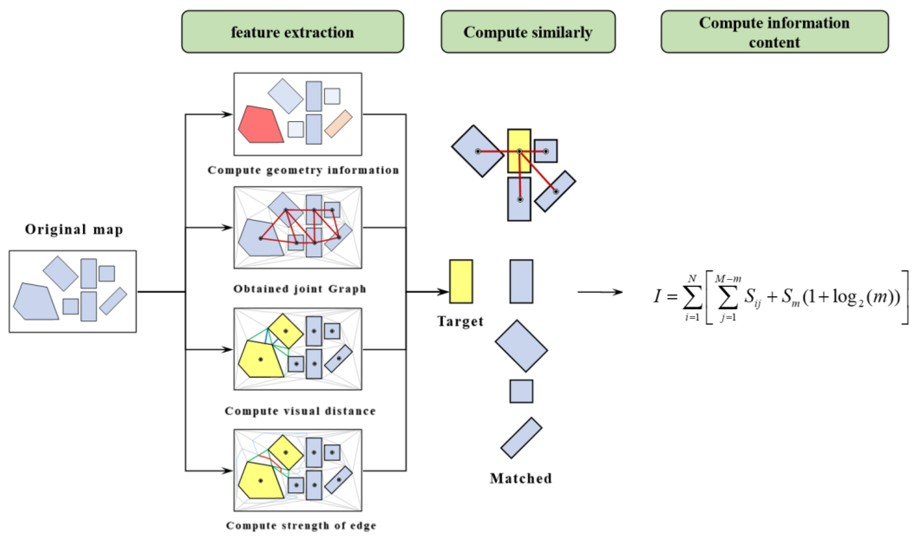
Spatial distribution information in area maps refers to the information represented by the spatial location, topological relationships, distance relationships, and other characteristics of area objects within the map space [
4,
26]. Existing methods extract spatial distribution relationships by constructing topological graph structures based on the centroids of area objects [
14,
15] or spatial adjacency graph structures based on the Voronoi diagram of area objects [
16,
17]. These graph structures are then used to measure the spatial distribution information of area maps. As area maps encompass both continuous and discrete areal objects, the approach of using Voronoi diagram tessellation to construct spatial adjacency graph structures is more widely applicable.
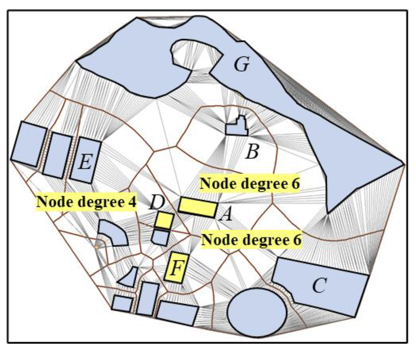
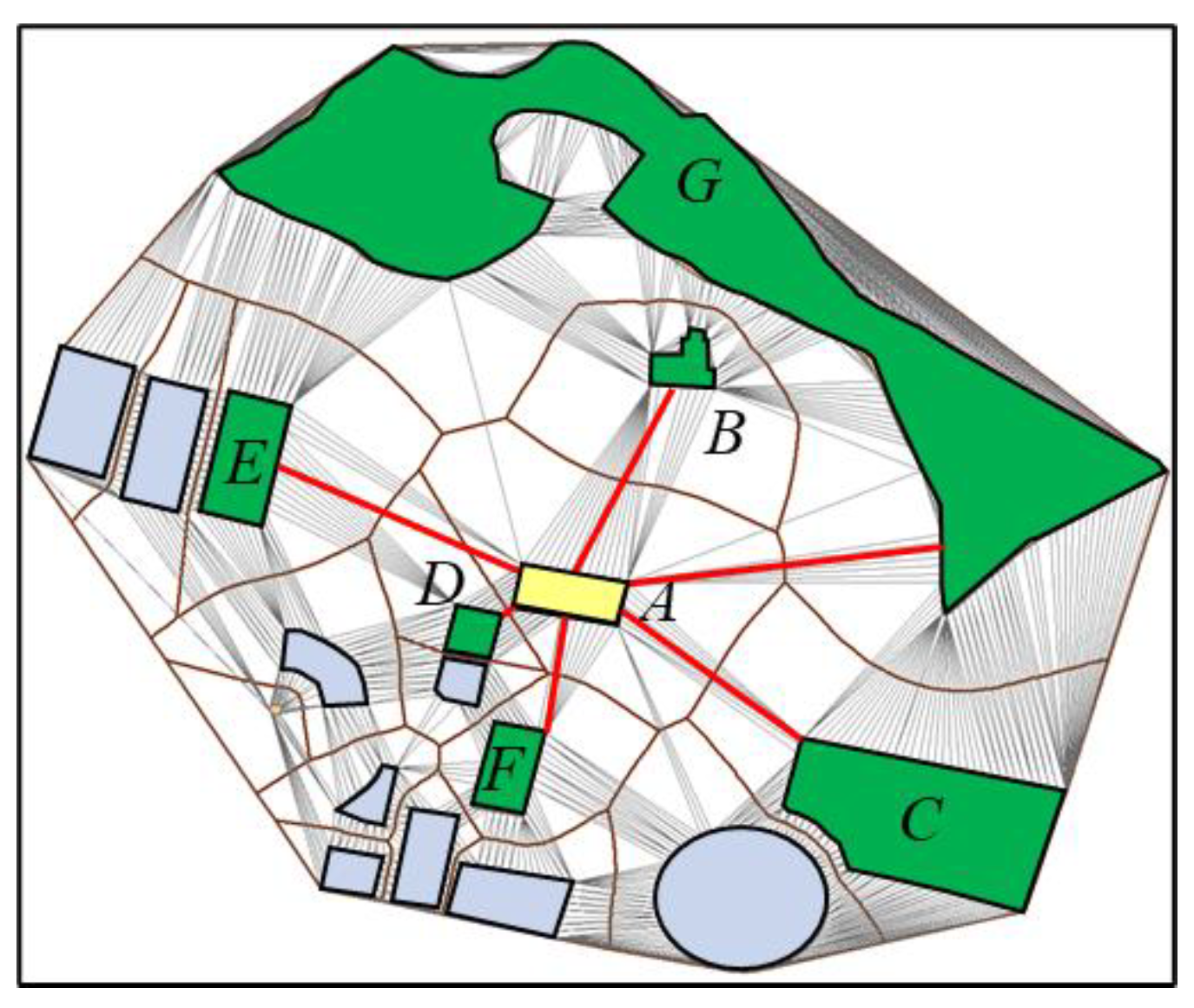
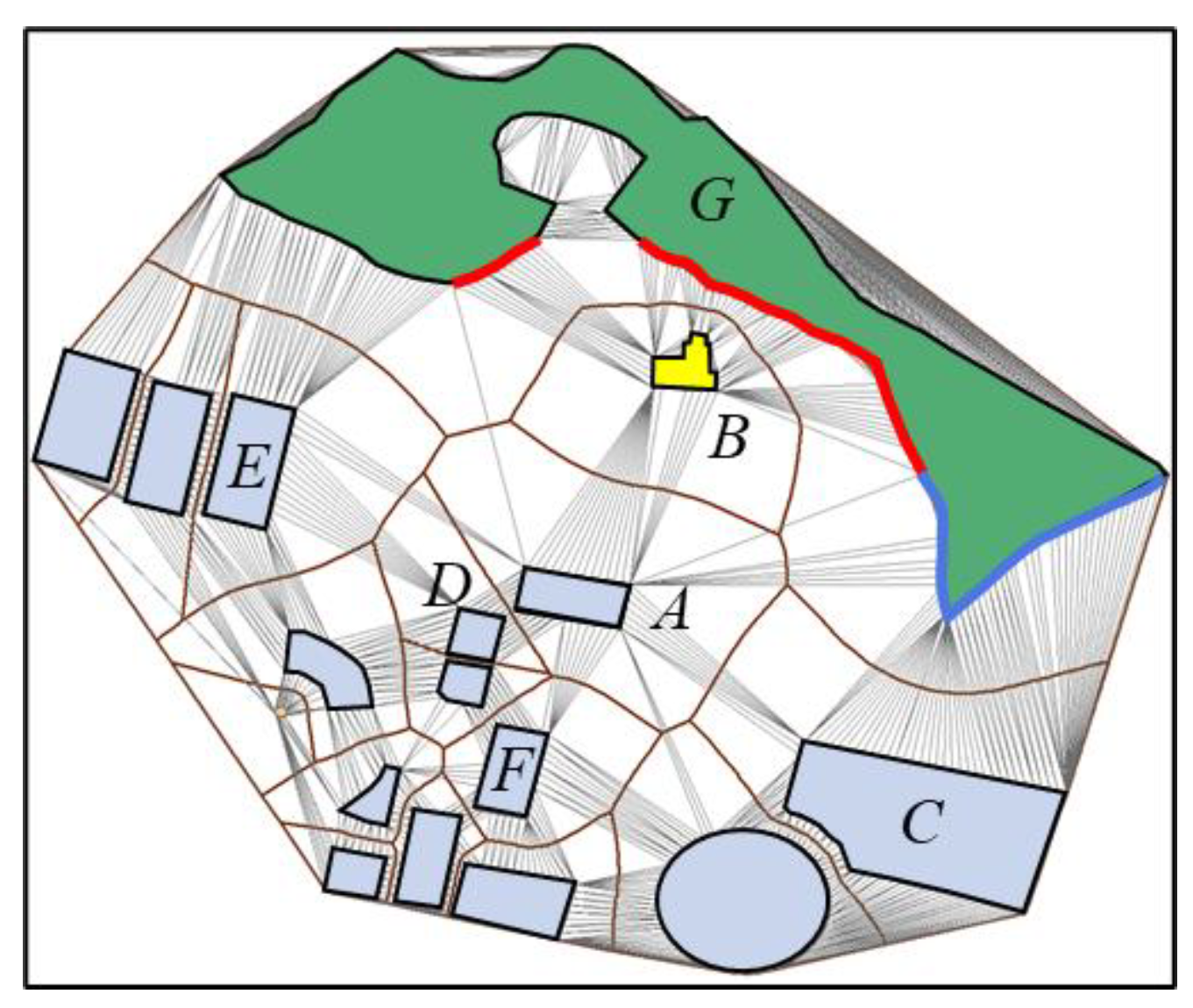
In existing studies, Li et al. have measured the spatial distribution information of area maps by using the adjacency degree of area objects and the difference in types of adjacent area objects as metrics [
16]. Liu et al., on the other hand, have expressed the distance relationship between area objects through the size of their Voronoi diagram areas, and have expressed the spatial distribution relationship using the adjacency degree of area objects [
17]. These metrics are then weighted and combined to comprehensively measure the spatial distribution relationship.
Li’s method considers the differences in types of area objects in their distribution patterns. However, in practical applications, there may be instances where all area objects belong to the same type, which limits the applicability of the information measurement model. Furthermore, this measurement model fails to consider the spatial configuration relationships between adjacent area objects and can only provide quantitative statistics, resulting in incomplete information measurement. Finally, Li’s study requires specific regulations on the size of area maps, which restricts the universality of spatial information measurement.
In Liu’s method, the author employs the size of Voronoi diagram areas to represent the distance relationships between area objects. However, there may be heterogeneity in the diagram, where the distance relationships between area objects and their adjacent objects exhibit heterogeneity. The use of a uniform indicator to characterize the distance relationships neglects the diversity of spatial distance relationships among area objects. Secondly, the author constructs Voronoi diagrams by extending the area maps outward by 30%. This approach leads to inconsistencies in the extension range for different map sizes, resulting in significant fluctuations in the Voronoi diagram areas of objects near the map boundaries. This, in turn, affects the stability and consistency of the measurement results.
2.3. Existing Shortcomings
Currently, only Li and Liu have proposed comprehensive measurement schemes for spatial information in area maps. Both scholars adopt a weighted summation approach to integrate geometric information and spatial distribution information, resulting in a comprehensive measurement of spatial information content in area maps. In their methods, due to a lack of systematic analysis of the quantitative relationship between geometric information and spatial distribution information, both models treat these two types of information as equally important. This paper argues that geometric morphological characteristics are the foundation of spatial distribution relationships, and the two types of information should interact with each other in the study of spatial information measurement. However, the weighted summation approach is unable to capture the diversity of this interaction.
In summary, there are three main shortcomings in existing research that urgently need to be addressed:
- (1)
The existing methods for measuring the geometric information content of area objects lack a unified calculation standard and rely heavily on manual experience, resulting in high degrees of error and subjectivity in the calculation results.
- (2)
The existing methods for measuring spatial distribution information content only consider the richness of spatial adjacency and spatial occupancy information, while failing to effectively consider the spatial morphological relationships, spatial distance relationships, and further spatial arrangement characteristics of area objects.
- (3)
There is currently no theoretically feasible solution for comprehensively measuring the geometric information and spatial distribution information of area maps. The current approach of combining weights based on manual experience carries an uncertain degree of subjectivity.


