
Development of a Digital Twin of the Harbour Waters and Surrounding Infrastructure Based on Spatial Data Acquired with Multimodal and Multi-Sensor Mapping Systems

 , , ,
, , ,
Abstract
:1. Introduction
- How can we use a time server to integrate measurement data?
- Will using modified Q-ST transformation to integrate data from different measurement platforms improve the accuracy of data fusion?
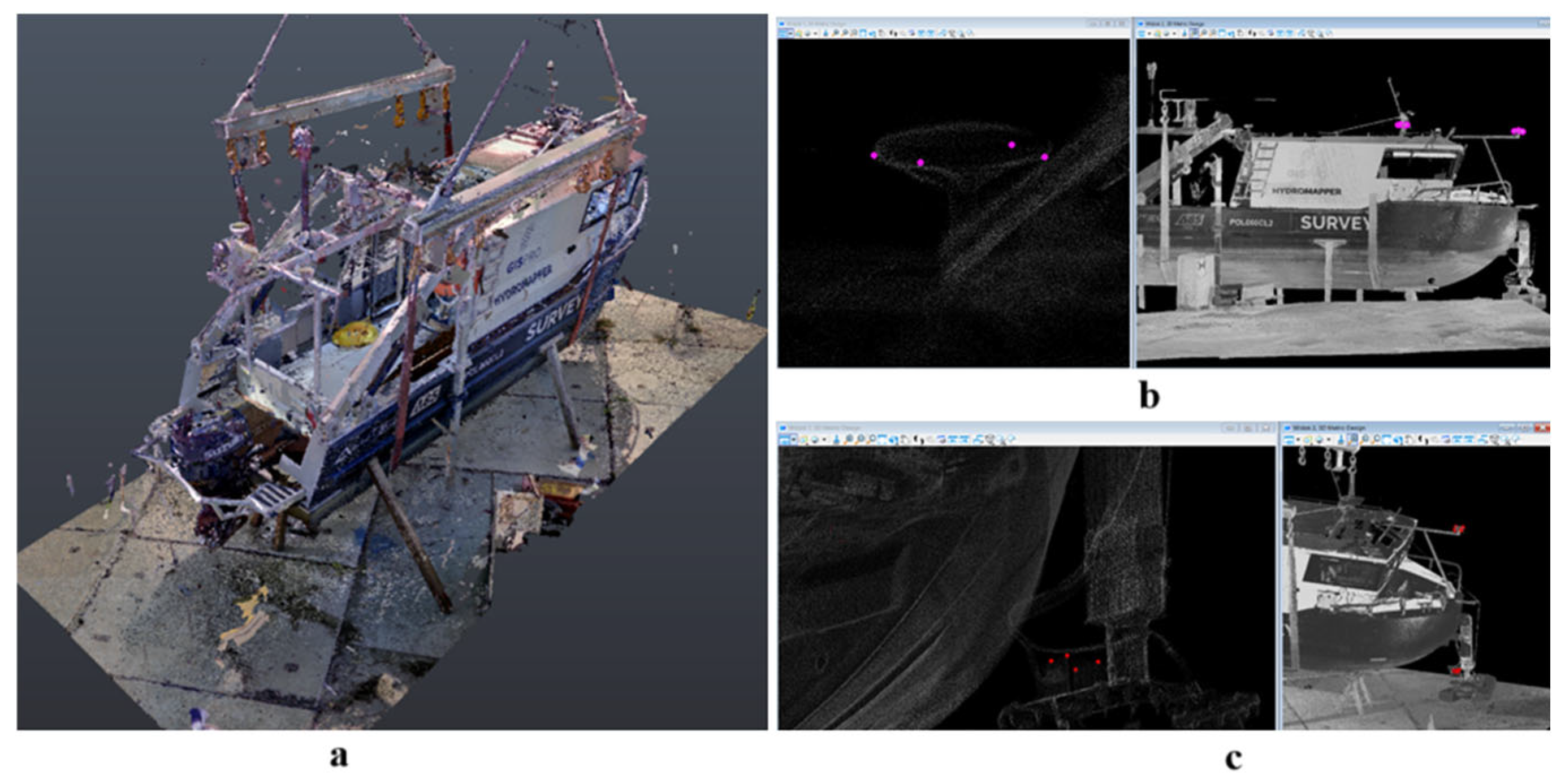
- How do we measure the offsets of survey equipment on a hydrographic boat to ensure high accuracy of their determination (within a few millimetres)?
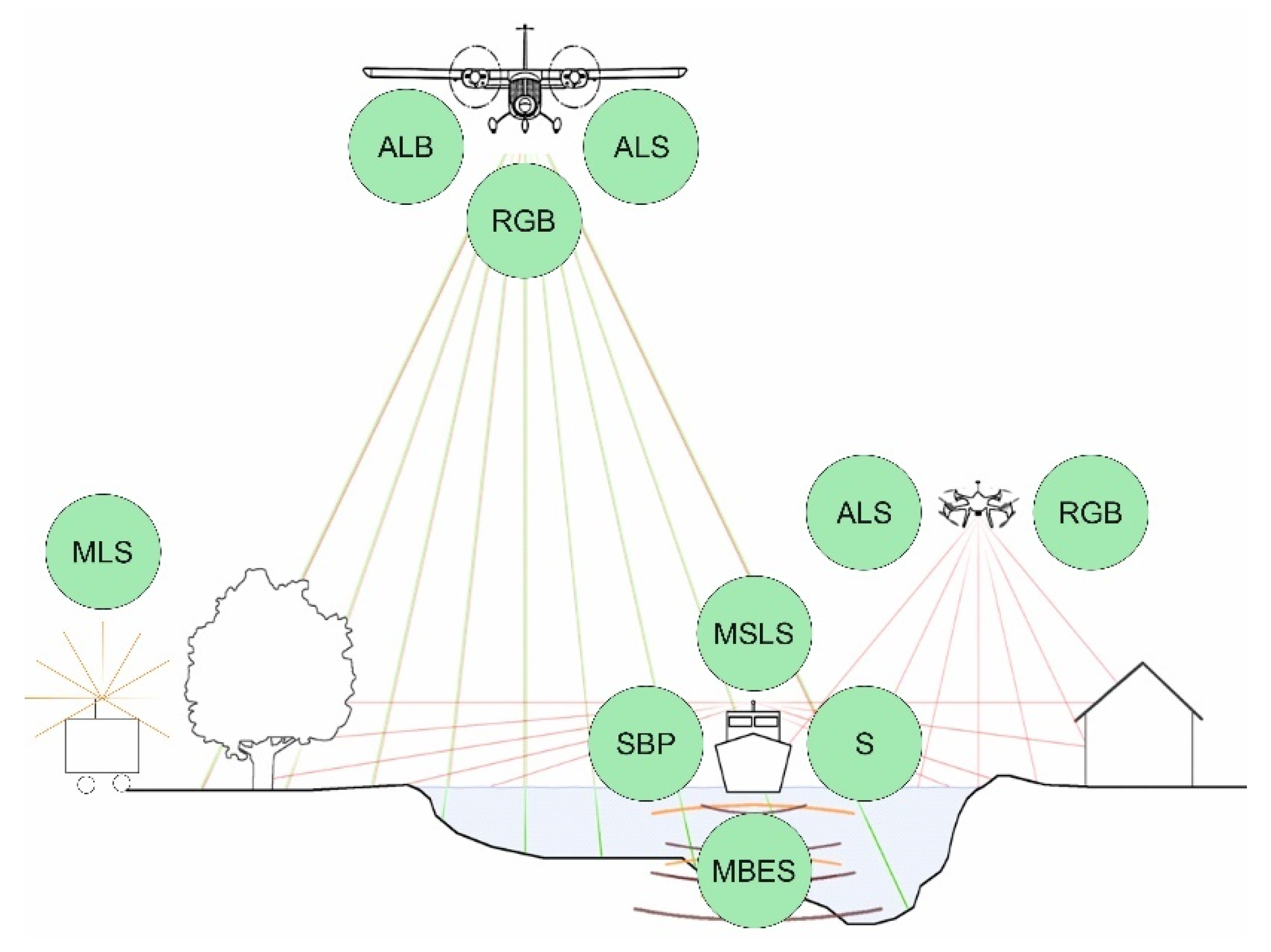
- ALS—Airborne Laser Scanning.
- ALB—Airborne Laser Bathymetry.
- MSLS—Mobile Surface Laser Scanning onboard.
- MLS—Mobile Laser Scanning on Land.
- MBES—multibeam echosounder.
- SBP—Sub-Bottom Profiler.
- S—Side Scan Sonar.
- Measurements of DGNSS—Differential Global Navigation Satellite System.
- Airborne aerial photogrammetry and UAV.
2. Materials and Methods
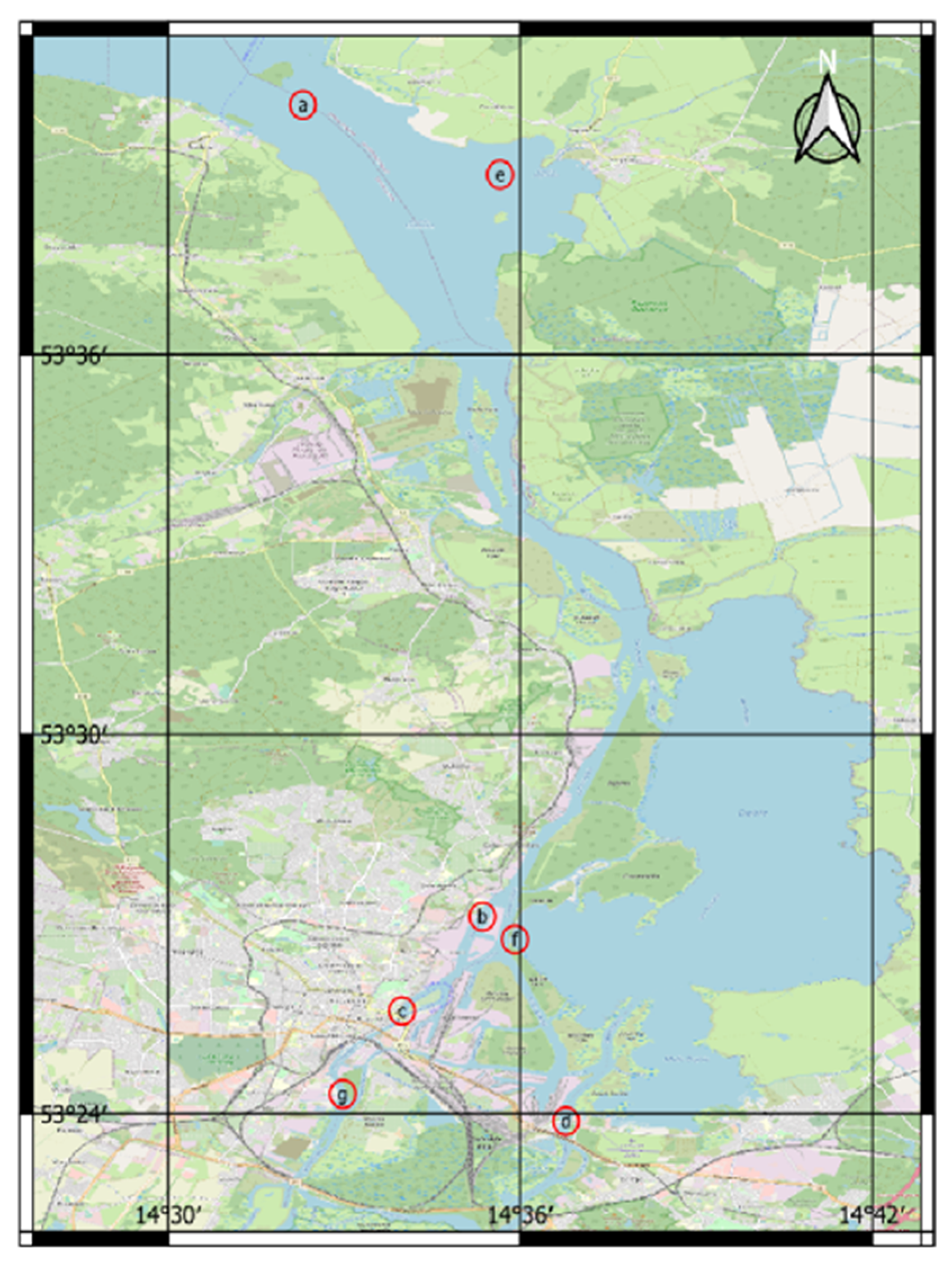
2.1. Study Area
- a.
- Trzebież (waterway—open area of the Szczecin Lagoon)—body of sea water;
- b.
- Brdowski Bridge—body of sea water located in Szczecin;
- c.
- Szczecin centre—Chrobry Embankment area—a body of water connecting sea and inland waters;
- d.
- Cłowy and Dębska Struga Bridges—inland water body;
- e.
- Stepnica—waterway, turntable, port—sea water area;
- f.
- Orli Przesmyk—sea and inland water area;
- g.
- Western Oder—inland water area in Szczecin;
- h.
- Siecino Lake (West Pomeranian Voivodeship—coordinates: 53.6246884, 16.0145501).

| Area | Measurement System | |||||||
|---|---|---|---|---|---|---|---|---|
| Airborne Laser Scanning | Airborne Laser Bathymetry | Mobile Laser Scanning on Land | Unmanned Aerial Vehicle | Mobile Surface Laser Scanning Onboard | Multibeam Echosounder | Sub-Bottom Profiler | Side Scan Sonar | |
| a | + | + | + | + | + | |||
| b | + | + | + | + | + | + | + | |
| c | + | + | + | + | + | + | + | |
| d | + | + | + | + | + | |||
| e | + | + | + | + | + | + | ||
| f | + | + | + | + | + | + | ||
| g | + | + | + | + | ||||
| h | + | + | + | + | + | + | ||
2.2. Materials
- Multibeam echosounder: R2Sonic 2024 (R2Sonic LLC, Austin, TX, USA).
- Positioning system INS: I2NS™ Type I (Applanix, Oswestry, UK).
- SVS and SVP: Valeport water speed of sound sensors (Valeport, Devon, UK).
- Side-scan sonar Edgetech 4125 (EdgeTech, West Wareham, MA, USA);
- Parametric sonar Subbottom profiler (SBP) Innomar SES-2000 (Innomar Technologie GmbH, Rostock, Germany);
- Underwater positioning system USBL Easy Track (Aae Technologies, Great Yarmouth, UK;
- Heading Sensor iXblue (iXblue Inc., Denver, CO, USA).
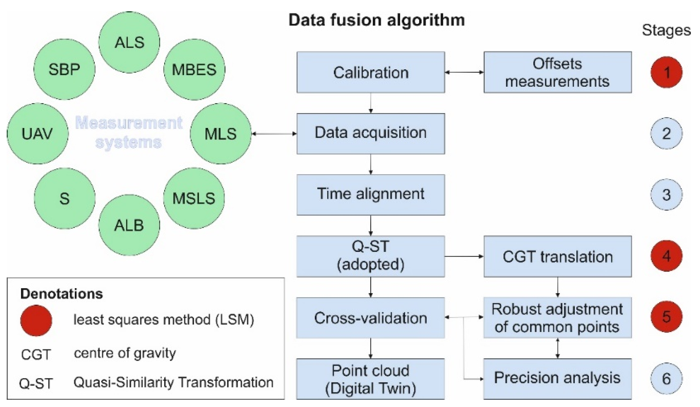
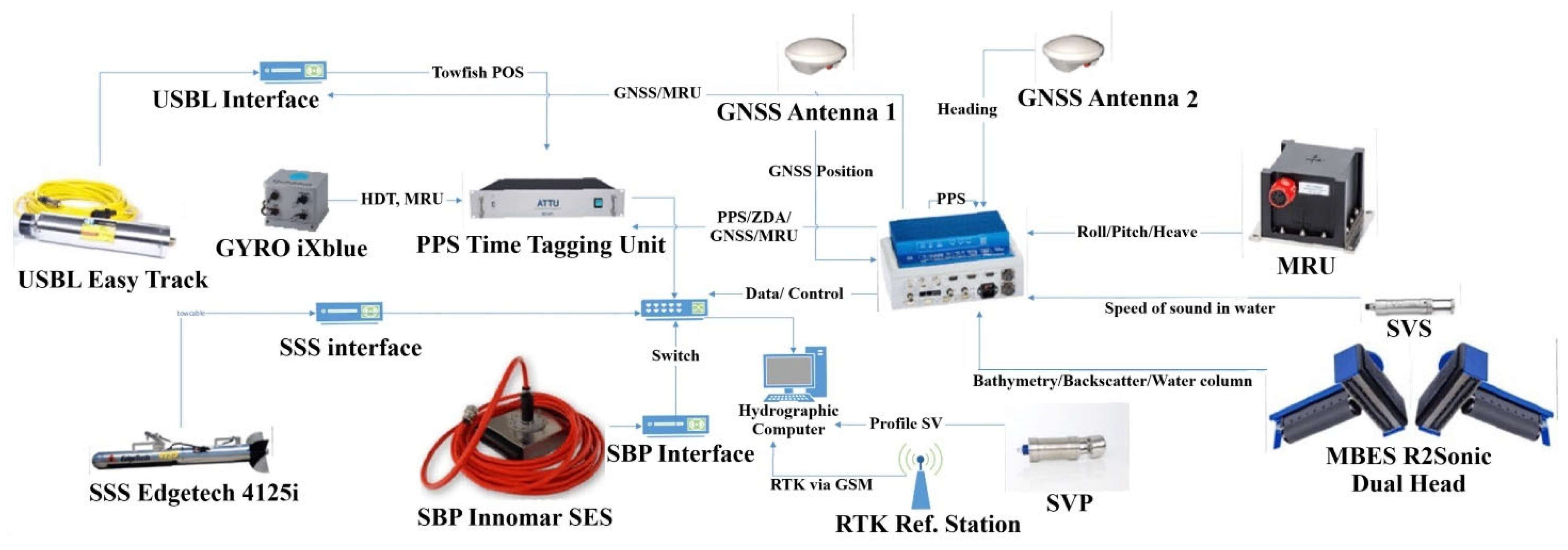
2.3. Methodology
- Use of a wide variety of platforms and measurement systems: aerial, surface, terrestrial, and underwater;
- Determination of offsets of measuring devices on hydrographic boats using a new measurement and calculation method;
- Time synchronisation of measurements by using a Time Tagging Unit time server;
- Use of a modified Q-ST transformation to combine point clouds by changing the sequence of calculations and applying a robustness criterion based on the lengths of homologous vectors while reducing the number of these vectors to the vectors with the highest confidence level.
- X—vector of unknown parameters;
- A—matrix of coefficients (partial derivatives —Jacobian transformation);
- L—constants vector.
3. Results
3.1. Offsets Measurement
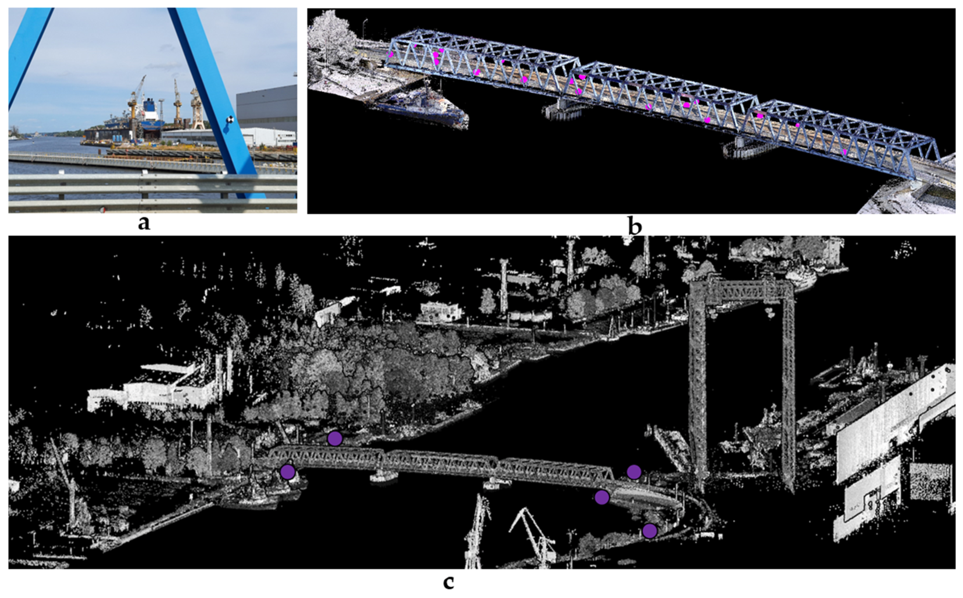
3.2. Hydrographic Surveys
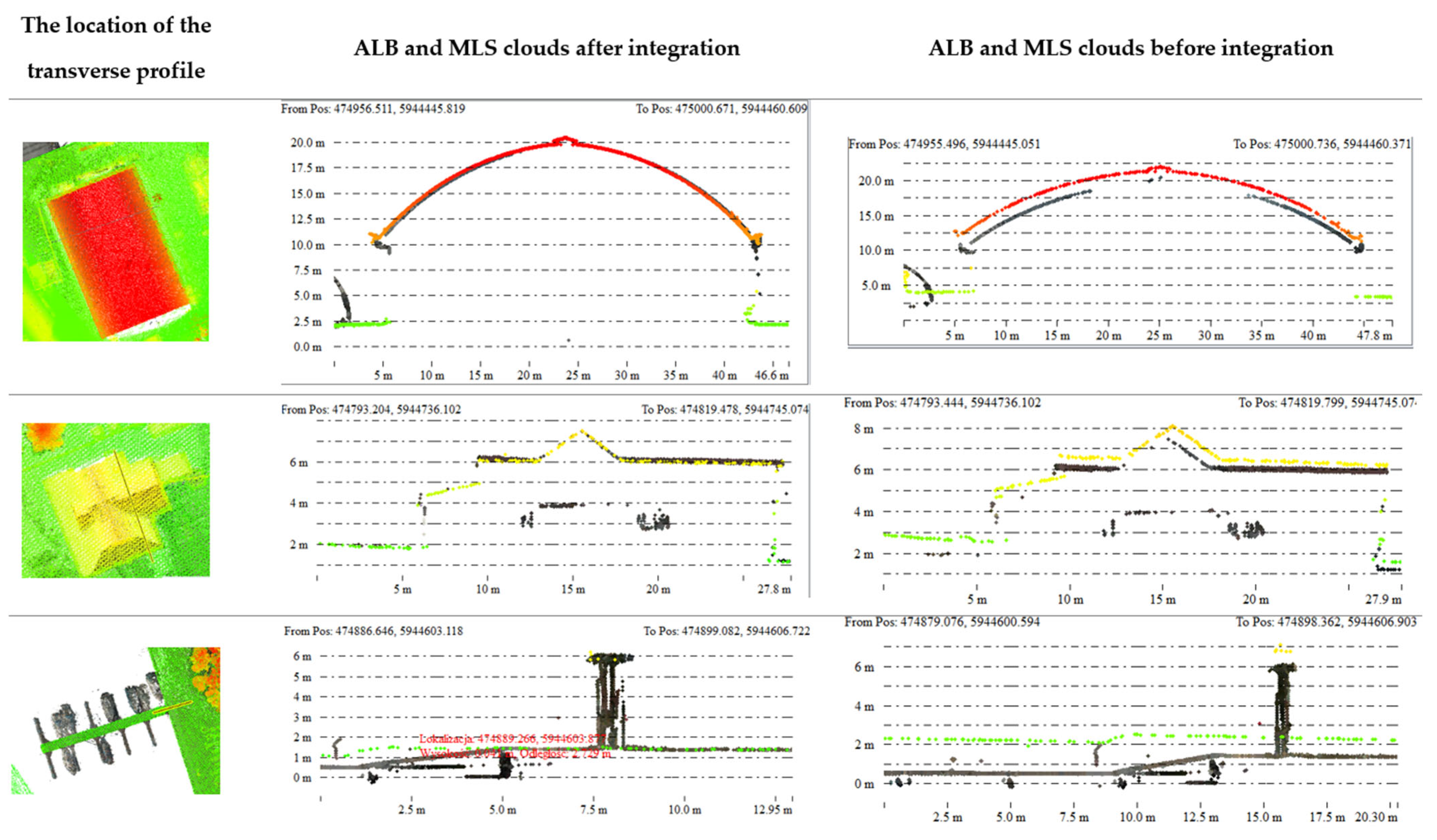
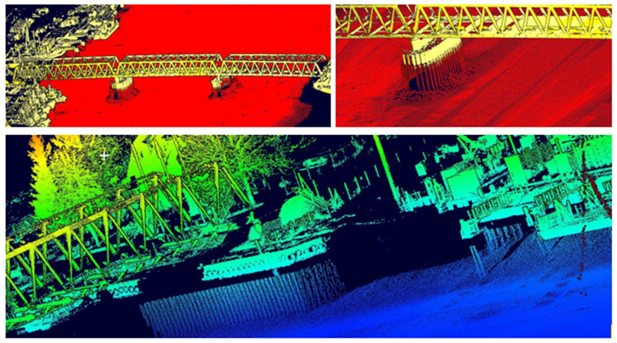
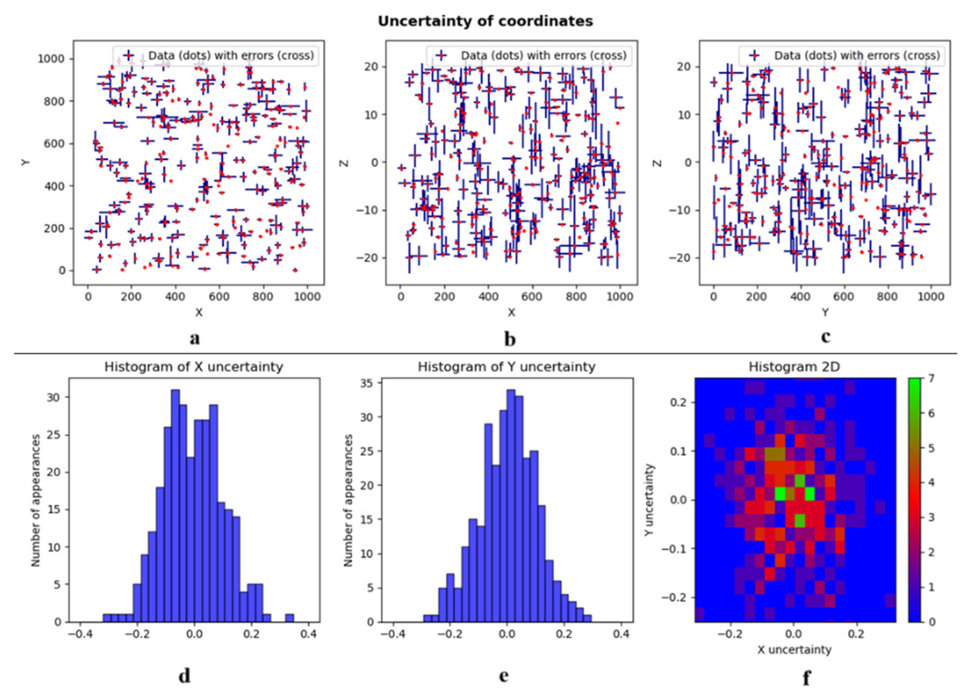
3.3. Data Integration and Cross-Validation
4. Discussion
5. Conclusions
Author Contributions
Funding
Institutional Review Board Statement
Informed Consent Statement
Data Availability Statement
Acknowledgments
Conflicts of Interest
References
- Tomsett, C.; Leyland, J. Remote Sensing of River Corridors: A Review of Current Trends and Future Directions. River Res. Appl. 2019, 35, 779–803. [Google Scholar] [CrossRef]
- Stateczny, A.; Wlodarczyk-Sielicka, M.; Gronska, D.; Motyl, W. Multibeam Echosounder and LiDAR in Process of 360-Degree Numerical Map Production for Restricted Waters with HydroDron. In Proceedings of the 2018 Baltic Geodetic Congress (BGC Geomatics), Olsztyn, Poland, 21–23 June 2018; pp. 288–292. [Google Scholar]
- Quadros, N. Unlocking the Characteristics of Bathymetric LiDAR Sensors. LiDAR Mag. 2013, 3, 62–67. [Google Scholar]
- Prošek, J.; Gdulová, K.; Barták, V.; Vojar, J.; Solský, M.; Rocchini, D.; Moudrý, V. Integration of Hyperspectral and LiDAR Data for Mapping Small Water Bodies. Int. J. Appl. Earth Obs. Geoinf. 2020, 92, 102181. [Google Scholar] [CrossRef]
- Singh, A.; Vyas, V. A Review on Remote Sensing Application in River Ecosystem Evaluation. Spat. Inf. Res. 2022, 30, 759–772. [Google Scholar] [CrossRef]
- Flener, C.; Vaaja, M.; Jaakkola, A.; Krooks, A.; Kaartinen, H.; Kukko, A.; Kasvi, E.; Hyyppä, H.; Hyyppä, J.; Alho, P. Seamless Mapping of River Channels at High Resolution Using Mobile LiDAR and UAV-Photography. Remote Sens. 2013, 5, 6382–6407. [Google Scholar] [CrossRef]
- Pöppl, F.; Neuner, H.; Mandlburger, G.; Pfeifer, N. Integrated Trajectory Estimation for 3D Kinematic Mapping with GNSS, INS and Imaging Sensors: A Framework and Review. ISPRS J. Photogramm. Remote Sens. 2023, 196, 287–305. [Google Scholar] [CrossRef]
- Stępień, G.; Tomczak, A.; Loosaar, M.; Ziębka, T. Dimensioning Method of Floating Offshore Objects by Means of Quasi-Similarity Transformation with Reduced Tolerance Errors. Sensors 2020, 20, 6497. [Google Scholar] [CrossRef]
- Available online: https://www.digitaltwinconsortium.org/ (accessed on 22 December 2024).
- Li, W.; Ma, Z.; Li, J.; Li, Q.; Li, Y.; Yang, J. Digital Twin Smart Water Conservancy: Status, Challenges, and Prospects. Water 2024, 16, 2038. [Google Scholar] [CrossRef]
- Jones, D.; Snider, C.; Nassehi, A.; Yon, J.; Hicks, B. Characterising the Digital Twin: A Systematic Literature Review. CIRP J. Manuf. Sci. Technol. 2020, 29, 36–52. [Google Scholar] [CrossRef]
- Söderberg, R.; Wärmefjord, K.; Carlson, J.S.; Lindkvist, L. Toward a Digital Twin for Real-Time Geometry Assurance in Individualized Production. CIRP Ann. Manuf. Technol. 2017, 66, 137–140. [Google Scholar] [CrossRef]
- Movva, S.S. Efficient Water Management through Intelligent Digital Twins. J. Technol. Syst. 2024, 6, 1–13. [Google Scholar] [CrossRef]
- Wu, X.; Lu, G.; Wu, Z. Remote Sensing Technology in the Construction of Digital Twin Basins: Applications and Prospects. Water 2023, 15, 2040. [Google Scholar] [CrossRef]
- Park, D.; You, H. A Digital Twin Dam and Watershed Management Platform. Water 2023, 15, 2106. [Google Scholar] [CrossRef]
- Sheng, D.; Lou, Y.; Sun, F.; Xie, J.; Yu, Y. Reengineering and Its Reliability: An Analysis of Water Projects and Watershed Management under a Digital Twin Scheme in China. Water 2023, 15, 3203. [Google Scholar] [CrossRef]
- Division, G.; Reality, S.D.; Trk, L.P. Reality Capture Trends Shaping an Autonomous Future. GIM Int. 2023, 37, 33–35. [Google Scholar]
- Talkhestani, B.A.; Jazdi, N.; Schloegl, W.; Weyrich, M. Consistency Check to Synchronize the Digital Twin of Manufacturing Automation Based on Anchor Points. Procedia CIRP 2018, 72, 159–164. [Google Scholar] [CrossRef]
- Grieves, M.; Vickers, J. Digital Twin: Mitigating Unpredictable, Undesirable Emergent Behavior in Complex Systems. In Transdisciplinary Perspectives on Complex Systems: New Findings and Approaches; Springer: Cham, Switzerland, 2016; pp. 85–113. [Google Scholar] [CrossRef]
- Damjanovic-Behrendt, V. A Digital Twin-Based Privacy Enhancement Mechanism for the Automotive Industry. In Proceedings of the 9th International Conference on Intelligent Systems 2018: Theory, Research and Innovation in Applications, London, UK, 6–7 September 2018; pp. 272–279. [Google Scholar] [CrossRef]
- Hu, L.; Nguyen, N.T.; Tao, W.; Leu, M.C.; Liu, X.F.; Shahriar, M.R.; Al Sunny, S.M.N. Modeling of Cloud-Based Digital Twins for Smart Manufacturing with MT Connect. Procedia Manuf. 2018, 26, 1193–1203. [Google Scholar] [CrossRef]
- Detzner, A.; Eigner, M. A Digital Twin for Root Cause Analysis and Product Quality Monitoring. In Proceedings of the International Design Conference, DESIGN, Daegu, Republic of Korea, 12–15 November 2018; Volume 4, pp. 1547–1558. [Google Scholar] [CrossRef]
- Wagner, C.; Grothoff, J.; Epple, U.; Drath, R.; Malakuti, S.; Grüner, S.; Hoffmeister, M.; Zimermann, P. The Role of the Industry 4.0 Asset Administration Shell and the Digital Twin during the Life Cycle of a Plant. In Proceedings of the IEEE International Conference on Emerging Technologies and Factory Automation, ETFA, Limassol, Cyprus, 12–15 September 2017; pp. 1–8. [Google Scholar] [CrossRef]
- Binyu, L.; Patrick Janssen, J.S.; Biljecki, F. Uncovering the Challenges of Urban Digital Twins. GIM Int. 2023, 37, 18–21. [Google Scholar]
- ZEB4ZEN Interreg Central Europe. Available online: https://www.interreg-central.eu/projects/zeb4zen/ (accessed on 22 December 2024).
- Non-Executive Think Tank on Digital Twin Strategy for Indian Infrastructure. 2023. Available online: https://geospatialworld.net/consulting/india-bim-and-digital-twin-think-tank.html (accessed on 22 December 2024).
- Dwivedi, Y.K.; Hughes, L.; Baabdullah, A.M.; Ribeiro-Navarrete, S.; Giannakis, M.; Al-Debei, M.M.; Dennehy, D.; Metri, B.; Buhalis, D.; Cheung, C.M.K.; et al. Metaverse beyond the Hype: Multidisciplinary Perspectives on Emerging Challenges, Opportunities, and Agenda for Research, Practice and Policy. Int. J. Inf. Manag. 2022, 66, 102542. [Google Scholar] [CrossRef]
- Kolbe, T.H.; Gröger, G.; Plümer, L. CityGML: Interoperable Access to 3D City Models. In Geo-Information for Disaster Management; Springer: Berlin/Heidelberg, Germany, 2005; pp. 883–899. [Google Scholar] [CrossRef]
- El-Ashmawy, K.L.A. A Comparison between Analytical Aerial Photogrammetry, Laser Scanning, Total Station and Global Positioning System Surveys for Generation of Digital Terrain Model. Geocarto Int. 2015, 30, 154–162. [Google Scholar] [CrossRef]
- Szafarczyk, A.; Toś, C. The Use of Green Laser in LiDAR Bathymetry: State of the Art and Recent Advancements. Sensors 2023, 23, 292. [Google Scholar] [CrossRef] [PubMed]
- Kogut, T.; Slowik, A. Classification of Airborne Laser Bathymetry Data Using Artificial Neural Networks. IEEE J. Sel. Top. Appl. Earth Obs. Remote Sens. 2021, 14, 1959–1966. [Google Scholar] [CrossRef]
- Schwarz, R.; Mandlburger, G.; Pfennigbauer, M.; Pfeifer, N. Design and Evaluation of a Full-Wave Surface and Bottom-Detection Algorithm for LiDAR Bathymetry of Very Shallow Waters. ISPRS J. Photogramm. Remote Sens. 2019, 150, 1–10. [Google Scholar] [CrossRef]
- McCarthy, M.J.; Otis, D.B.; Hughes, D.; Muller-Karger, F.E. Automated High-Resolution Satellite-Derived Coastal Bathymetry Mapping. Int. J. Appl. Earth Obs. Geoinf. 2022, 107, 102693. [Google Scholar] [CrossRef]
- Śledziowski, J.; Terefenko, P.; Giza, A.; Forczmański, P.; Łysko, A.; Maćków, W.; Stępień, G.; Tomczak, A.; Kurylczyk, A. Application of Unmanned Aerial Vehicles and Image Processing Techniques in Monitoring Underwater Coastal Protection Measures. Remote Sens. 2022, 14, 458. [Google Scholar] [CrossRef]
- Tomczak, A.; Stępień, G.; Abramowski, T.; Bejger, A. Subsea Wellhead Spud-in Marking and as-Built Position Estimation Method Based on Ultra-Short Baseline Acoustic Positioning. Measurement 2022, 195, 111155. [Google Scholar] [CrossRef]
- Wang, X.; Yang, F.; Zhang, H.; Su, D.; Wang, Z.; Xu, F. Registration of Airborne LiDAR Bathymetry and Multibeam Echo Sounder Point Clouds. IEEE Geosci. Remote Sens. Lett. 2022, 19, 1–5. [Google Scholar] [CrossRef]
- Li, S.; Su, D.; Yang, F.; Zhang, H.; Wang, X.; Guo, Y. Bathymetric LiDAR and Multibeam Echo-Sounding Data Registration Methodology Employing a Point Cloud Model. Appl. Ocean Res. 2022, 123, 103147. [Google Scholar] [CrossRef]
- Costa, B.M.; Battista, T.A.; Pittman, S.J. Comparative Evaluation of Airborne LiDAR and Ship-Based Multibeam SoNAR Bathymetry and Intensity for Mapping Coral Reef Ecosystems. Remote Sens. Environ. 2009, 113, 1082–1100. [Google Scholar] [CrossRef]
- Irish, J.L.; White, T.E. Coastal Engineering Applications of High-Resolution Lidar Bathymetry. Coast. Eng. 1998, 35, 47–71. [Google Scholar] [CrossRef]
- Pan, Z.; Glennie, C.; Fernandez-Diaz, J.C.; Shrestha, R.; Carter, B.; Hauser, D.; Singhania, A.; Sartori, M. Fusion of Bathymetric LiDAR and Hyperspectral Imagery for Shallow Water Bathymetry. In Proceedings of the International Geoscience and Remote Sensing Symposium (IGARSS), Beijing, China, 10–15 July 2016; Volume 2016, pp. 3792–3795. [Google Scholar] [CrossRef]
- Doneus, M.; Briese, C.; Studnicka, N. Analysis of Full-Waveform ALS Data by Simultaneously Acquired TLS Data: Towards an Advanced DTM Generation in Wooded Areas. In Proceedings of the ISPRS Technical Commission VII Symposium 100 Years ISPRS Advancing Remote Sensing Science, Vienna, Austria, 5–7 July 2010; Volume XXXVIII, pp. 193–198. [Google Scholar]
- Guo, Y.; Feng, C.; Xu, W.; Liu, Y.; Su, D.; Qi, C.; Dong, Z. Water-Land Classification for Single-Wavelength Airborne LiDAR Bathymetry Based on Waveform Feature Statistics and Point Cloud Neighborhood Analysis. Int. J. Appl. Earth Obs. Geoinf. 2023, 118, 103268. [Google Scholar] [CrossRef]
- Eren, F.; Pe’eri, S.; Rzhanov, Y.; Ward, L. Bottom Characterization by Using Airborne Lidar Bathymetry (ALB) Waveform Features Obtained from Bottom Return Residual Analysis. Remote Sens. Environ. 2018, 206, 260–274. [Google Scholar] [CrossRef]
- Hoggarth, A.; Foster, B.; Cove, K. Evolving Airborne Bathymetric LiDAR to New Depths with Artificial Intelligence. In Proceedings of the OCEANS 2022, Chennai, India, 21–24 February 2022; pp. 1–3. [Google Scholar] [CrossRef]
- Kussul, N.; Lavreniuk, M.; Skakun, S.; Shelestov, A. Deep Learning Classification of Land Cover and Crop Types Using Remote Sensing Data. IEEE Geosci. Remote Sens. Lett. 2017, 14, 778–782. [Google Scholar] [CrossRef]
- Janowski, L.; Wroblewski, R.; Rucinska, M.; Kubowicz-Grajewska, A.; Tysiac, P. Automatic Classification and Mapping of the Seabed Using Airborne LiDAR Bathymetry. Eng. Geol. 2022, 301, 106615. [Google Scholar] [CrossRef]
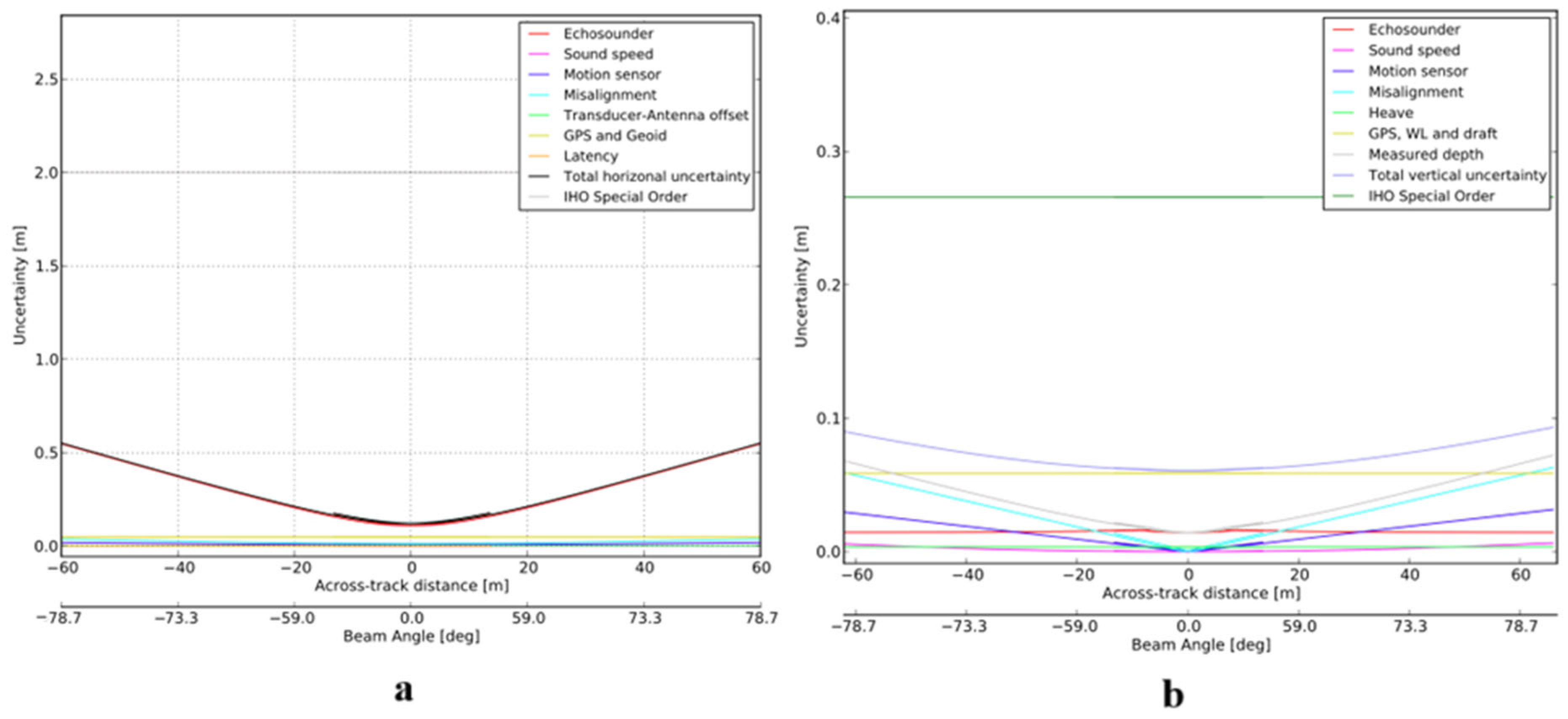
- Naankeu Wati, G.; Geldof, J.B.; Seube, N. Error budget analysis for surface and underwater survey system. Int. Hydrogr. Rev. 2016, 15, 21–46. [Google Scholar]
- Stepien, G.; Tomczak, A.; Tomasz, Z. Application of Total Free Station Method (TFS) for Offshore Surveying in Oblique Coordinate System. Int. J. Adv. Sci. Eng. Technol. 2019, 7, 32–37. [Google Scholar]
- Stepień, G.; Zalas, E.; Ziebka, T. New Approach to Isometric Transformations in Oblique Local Coordinate Systems of Reference. Geod. Cartogr. 2017, 66, 291–303. [Google Scholar] [CrossRef]
- S-44 Edition 6.1.0. Available online: https://iho.int/uploads/user/pubs/standards/s-44/S-44_Edition_6.1.0.pdf (accessed on 22 December 2024).
- Omer, M.; Margetts, L.; Hadi Mosleh, M.; Hewitt, S.; Parwaiz, M. Use of Gaming Technology to Bring Bridge Inspection to the Office. Struct. Infrastruct. Eng. 2019, 15, 1292–1307. [Google Scholar] [CrossRef]
- Tran, H.; Nguyen, T.N.; Christopher, P.; Bui, D.-K.; Khoshelham, K.; Ngo, T.D. A Digital Twin Approach for Geometric Quality Assessment of As-Built Prefabricated Façades. J. Build. Eng. 2021, 41, 102377. [Google Scholar] [CrossRef]
- Benzon, H.-H.; Chen, X.; Belcher, L.; Castro, O.; Branner, K.; Smit, J. An Operational Image-Based Digital Twin for Large-Scale Structures. Appl. Sci. 2022, 12, 3216. [Google Scholar] [CrossRef]
- Gobeawan, L.; Lin, E.S.; Tandon, A.; Yee, A.T.K.; Khoo, V.H.S.; Teo, S.N.; Yi, S.; Lim, C.W.; Wong, S.T.; Wise, D.J.; et al. Modeling trees for virtual singapore: From data acquisition to citygml models. Int. Arch. Photogramm. Remote Sens. Spat. Inf. Sci. 2018, XLII-4/W10, 55–62. [Google Scholar] [CrossRef]
- Xue, F.; Lu, W.; Chen, Z.; Webster, C.J. From LiDAR Point Cloud towards Digital Twin City: Clustering City Objects Based on Gestalt Principles. ISPRS J. Photogramm. Remote Sens. 2020, 167, 418–431. [Google Scholar] [CrossRef]
- Ma, Y.; Zheng, Y.; Wong, Y.D.; Easa, S.; Cheng, J. A Virtual Procedure for Real-Time Monitoring of Intervisibility between Conflicting Agents at Intersections Using Point Cloud and Trajectory Data. Transp. Res. Part C Emerg. Technol. 2022, 134, 103486. [Google Scholar] [CrossRef]
- Kähler, O.; Hochstöger, S.; Kemper, G.; Birchbauer, J. Automating powerline inspection: A novel multisensor system for data analysis using deep learning. Int. Arch. Photogramm. Remote Sens. Spat. Inf. Sci. 2020, XLIII-B4-2020, 747–754. [Google Scholar] [CrossRef]
- Mongus, D.; Brumen, M.; Žlaus, D.; Kohek, Š.; Tomažič, R.; Kerin, U.; Kolmanič, S. A Complete Environmental Intelligence System for LiDAR-Based Vegetation Management in Power-Line Corridors. Remote Sens. 2021, 13, 5159. [Google Scholar] [CrossRef]
- Heindl, W.; Stary, C. Structured Development of Digital Twins—A Cross-Domain Analysis towards a Unified Approach. Processes 2022, 10, 1490. [Google Scholar] [CrossRef]
- Centomo, S.; Avogaro, A.; Panato, M.; Tadiello, C.; Fummi, F. A Design Methodology of Multi-Level Digital Twins. In Proceedings of the 2021 22nd IEEE International Conference on Industrial Technology (ICIT), Virtual, 10–12 March 2021; IEEE: Valencia, Spain, 2021; pp. 961–966. [Google Scholar]
- Psarommatis, F.; May, G. A Literature Review and Design Methodology for Digital Twins in the Era of Zero Defect Manufacturing. Int. J. Prod. Res. 2023, 61, 5723–5743. [Google Scholar] [CrossRef]
- Schroeder, G.N.; Steinmetz, C.; Rodrigues, R.N.; Henriques, R.V.B.; Rettberg, A.; Pereira, C.E. A Methodology for Digital Twin Modeling and Deployment for Industry 4.0. Proc. IEEE 2021, 109, 556–567. [Google Scholar] [CrossRef]
- Aivaliotis, P.; Georgoulias, K.; Arkouli, Z.; Makris, S. Methodology for Enabling Digital Twin Using Advanced Physics-Based Modelling in Predictive Maintenance. Procedia CIRP 2019, 81, 417–422. [Google Scholar] [CrossRef]
- Riedelsheimer, T.; Gogineni, S.; Stark, R. Methodology to Develop Digital Twins for Energy Efficient Customizable IoT-Products. Procedia CIRP 2021, 98, 258–263. [Google Scholar] [CrossRef]


| Accuracy Estimation | Coordinates’ Accuracy After Transformation [m] | |
|---|---|---|
| Calculated for Total Station Point Cloud | Calculated for TLS Point Cloud | |
| Mean error | ||
| Total error (of point) | ||
| Accuracy Estimation | Coordinates’ Accuracy After Transformation [m] | |
|---|---|---|
| Calculated for Total Station Point Cloud | Calculated for TLS Point Cloud | |
| Mean error | ||
| Total error (of point) | ||
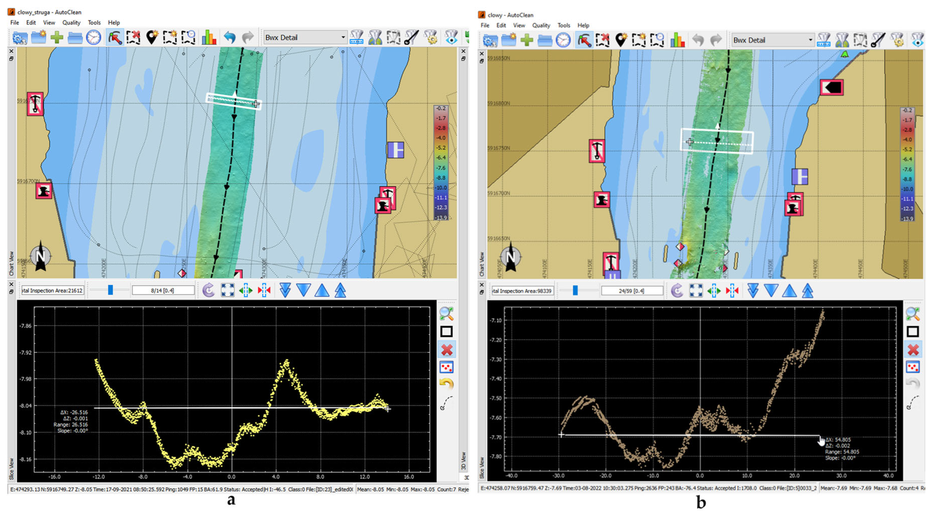
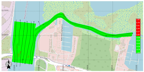
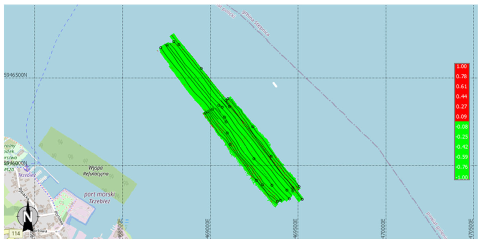
| Area (See Figure 2, Table 1) | QC Statistics |
|---|---|
 Area “Most Clowy” | Survey Accuracy: Standard = Exclusive Order, a = 0.150, b = 0.004 Footprints conform with survey accuracy: 25,016,768 (96.59%) |
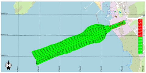 Area “Stepnica” | Survey Accuracy: Standard = Exclusive Order, a = 0.150, b = 0.004 Footprints conform with survey accuracy: 39,566,095 (98.93%) |
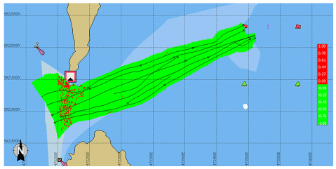 Area “Orli Przesmyk” | Survey Accuracy: Standard = IHO Special Order, a = 0.250, b = 0.007 Footprints conform with survey accuracy: 17,577,633 (98.77%) |
 Area “Trzebież” | Survey Accuracy: Standard = Exclusive Order, a = 0.150, b = 0.004 Footprints conform with survey accuracy: 21,263,698 (98.27%) |
| GSD [m] | Mean Errors [m] | |
|---|---|---|
| GCP | ICP | |
| Mean Errors of Control Points | |||||
|---|---|---|---|---|---|
| MLS [m] | MSLS [m] | ||||
| X | Y | Z | X | Y | Z |
| 0.034 | 0.048 | 0.059 | 0.046 | 0.044 | 0.056 |
| Accuracy of point | |||||
| Mean Errors [m] | |||||
|---|---|---|---|---|---|
| Q-ST (Adopted) | Similarity Transformation (Traditional Approach) | ||||
| X | Y | Z | X | Y | Z |
| 0.084 | 0.092 | 0.123 | 0.113 | 0.213 | 0.301 |
| Accuracy of point | |||||
Disclaimer/Publisher’s Note: The statements, opinions and data contained in all publications are solely those of the individual author(s) and contributor(s) and not of MDPI and/or the editor(s). MDPI and/or the editor(s) disclaim responsibility for any injury to people or property resulting from any ideas, methods, instructions or products referred to in the content. |
© 2024 by the authors. Licensee MDPI, Basel, Switzerland. This article is an open access article distributed under the terms and conditions of the Creative Commons Attribution (CC BY) license (https://creativecommons.org/licenses/by/4.0/).
Share and Cite
Tomczak, A.; Stępień, G.; Kogut, T.; Jedynak, Ł.; Zaniewicz, G.; Łącka, M.; Bodus-Olkowska, I. Development of a Digital Twin of the Harbour Waters and Surrounding Infrastructure Based on Spatial Data Acquired with Multimodal and Multi-Sensor Mapping Systems. Appl. Sci. 2025, 15, 315. https://doi.org/10.3390/app15010315
Tomczak A, Stępień G, Kogut T, Jedynak Ł, Zaniewicz G, Łącka M, Bodus-Olkowska I. Development of a Digital Twin of the Harbour Waters and Surrounding Infrastructure Based on Spatial Data Acquired with Multimodal and Multi-Sensor Mapping Systems. Applied Sciences. 2025; 15(1):315. https://doi.org/10.3390/app15010315
Chicago/Turabian StyleTomczak, Arkadiusz, Grzegorz Stępień, Tomasz Kogut, Łukasz Jedynak, Grzegorz Zaniewicz, Małgorzata Łącka, and Izabela Bodus-Olkowska. 2025. "Development of a Digital Twin of the Harbour Waters and Surrounding Infrastructure Based on Spatial Data Acquired with Multimodal and Multi-Sensor Mapping Systems" Applied Sciences 15, no. 1: 315. https://doi.org/10.3390/app15010315
APA StyleTomczak, A., Stępień, G., Kogut, T., Jedynak, Ł., Zaniewicz, G., Łącka, M., & Bodus-Olkowska, I. (2025). Development of a Digital Twin of the Harbour Waters and Surrounding Infrastructure Based on Spatial Data Acquired with Multimodal and Multi-Sensor Mapping Systems. Applied Sciences, 15(1), 315. https://doi.org/10.3390/app15010315