

Tectonic Geomorphology and Quaternary Activity Characteristics of the Jining River Northern Margin Fault, Inner Mongolia, North China


Abstract
:1. Introduction
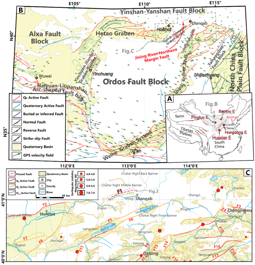
2. Geological Background
2.1. Regional Tectonic Setting
2.2. Distribution and Geological Characteristics of the JRNF
3. Methods
4. Results
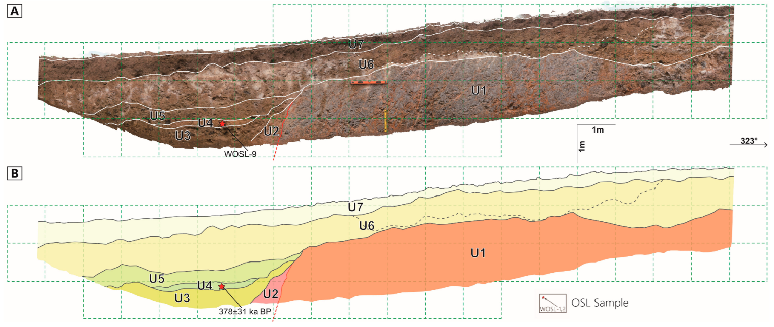
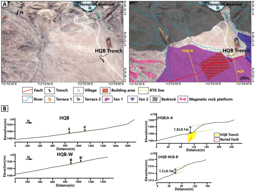
4.1. Hanqingba Village (Site 1)
4.1.1. Site Description and Fault Geomorphology
4.1.2. Evidence for Fault Activity and Parameters
- U1: Bedrock layer, gray-black, consisting of volcanic tuff forming the platform base.
- U2: Colluvial layer, reddish-brown, composed of medium to coarse sand mixed with fine gravel, representing typical wedge-shaped deposits in front of the scarp. The composition is mixed, primarily derived from the highly weathered and loose volcanic tuff of U1.
- U3: Alluvial layer, earthy yellow, with some directional features, small gravel size, and moderate consolidation.
- U4: Clay layer, yellow to reddish-brown, composed of fine silt to silty sand. It is inferred to be a stagnant water deposit in front of the scarp or a locally developed sedimentary lens, showing tight consolidation.
- U5: Alluvial layer, yellowish-brown, with poor sorting and rounding, small gravel size, and loose consolidation.
- U6: Alluvial layer, gray-white to earthy yellow, containing larger gravel clasts. The lower sediments show calcification and whitening, suggesting deposition from multiple alluvial events during the same period. The composition is relatively consistent, with poor sorting and rounding, and moderately tight consolidation.
- U7: Paleosol layer, black-yellow, containing medium to coarse gravel. It is soil-like and loosely consolidated.
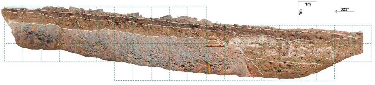
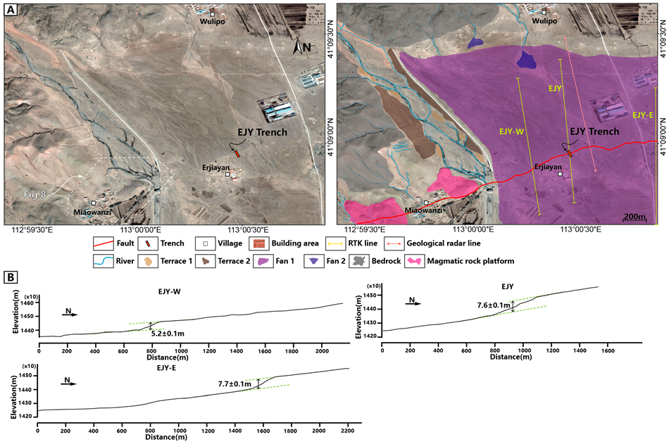
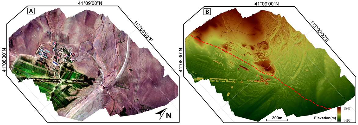
4.2. Erjiayan Village (Site 2)
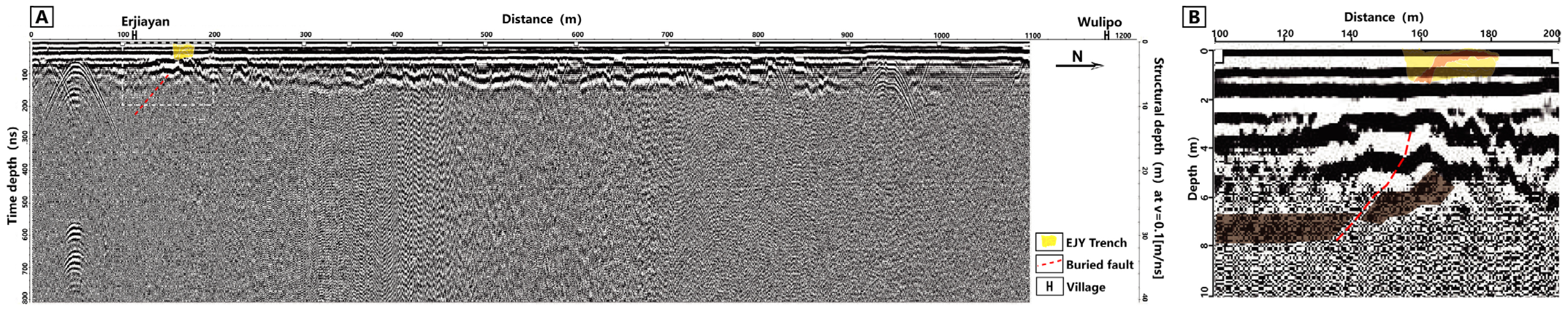
4.2.1. Site Description and Fault Geomorphology
4.2.2. Evidence for Fault Activity and Parameters
- U1: Alluvial layer, orange-yellow to brown, containing coarse to very large gravels, poorly sorted and poorly rounded. Local mud content shows slight horizontal bedding, with relatively strong consolidation.
- U2: Alluvial deposits, yellow-brown, composed of muddy coarse sand with fine gravels. Poorly rounded, lacking stratification, and relatively well consolidated.
- U3: Alluvial layer, gray-white to earthy yellow, exhibiting some directional features. Medium-sized gravels, poorly rounded, with slight horizontal bedding visible in local muddy areas. Relatively well consolidated.
- U4: Alluvial layer, reddish–brown to gray–brown, moderately sorted, poorly rounded, with large-sized gravels, and loosely consolidated. This layer shows evidence of sediment deformation, overlying U1, U2, and U3, likely caused by paleoseismic activity.
- U5: Loess layer, earthy yellow, silt-like, lacking stratification, and tightly consolidated.
- U6: Paleosol layer, dark brown, containing medium to fine gravels, with a soil-like texture, and loosely consolidated.

5. Discussion
5.1. Analysis of Tectonic Activity of JRNF
5.2. Evolution of Tectonic Activity and Geomorphology
5.3. Seismic Hazard Potential
6. Conclusions
- The JRNF is a NEE-trending frontal normal fault along the northern boundary of the Jining Basin, with a length of approximately 50 km. The fault controls the evolution of the Jining Basin, creating 1.5–1.8 m scarps at Hanqingba and 5.2–7.7 m scarps at Erjia Yan.
- The activity of the JRNF has gradually decreased since the late Middle Pleistocene (approximately 400 ka). During the Late Pleistocene, its activity did not rupture the surface, only exerting limited geomorphological control. The fault is classified as a late Middle Pleistocene to Late Pleistocene fault with no activity during the Holocene.
- A single surface-rupturing event on the JRNF could result in vertical displacements of up to 1 m. The estimated maximum earthquake magnitude is Mwg 6.95, indicating a significant seismic risk for the Jining Basin region.
Author Contributions
Funding
Data Availability Statement
Acknowledgments
Conflicts of Interest
References
- Deng, Q.; Cheng, S.; Min, W.; Yang, G.; Ren, D. Discussion on Cenozoic tectonics and dynamics of Ordos block. J. Geomech. 1999, 5, 13–21. (In Chinese) [Google Scholar]
- Li, Z.; Hao, M.; Hammond, W.C.; Cheng, F.; Zhang, G.; Wang, Q.; Liu, L.; Hou, B.; Gan, W. Geodetic constraints on three-component motion of the Ordos block (China) and their implications for lithospheric dynamics. GSA Bull. 2024, 136, 5217–5230. [Google Scholar] [CrossRef]
- Zhang, H.; He, Z.; Ma, B.; Long, J.; Liang, K.; Wang, J. The vertical slip rate of the Sertengshan piedmont fault, Inner Mongolia, China. J. Asian Earth Sci. 2017, 143, 95–108. [Google Scholar] [CrossRef]
- Luo, Q.; Li, C.; Ren, G.; Hu, X.; Li, X.; Li, Y. The 1673 Tianzhen Earthquake and Rupture Behavior of the Yanggao--Tianzhen Fault in the Northern Shanxi Graben, China. Tectonics 2023, 42, e2022TC007582. [Google Scholar] [CrossRef]
- Dong, S.; Zhang, P.; Zheng, W.; Yu, Z.; Lei, Q.; Yang, H.; Liu, J.; Gong, H. Paleoseismic observations along the Langshan range-front fault, Hetao Basin, China: Tectonic and seismic implications. Tectonophysics 2018, 730, 63–80. [Google Scholar] [CrossRef]
- Guo, Z.; Chen, Y. Crustal structure of the eastern Qinling orogenic belt and implication for reactivation since the Cretaceous. Tectonophysics 2016, 683, 1–11. [Google Scholar] [CrossRef]
- Guo, Z.; Chen, Y. Mountain building at northeastern boundary of Tibetan Plateau and craton reworking at Ordos block from joint inversion of ambient noise tomography and receiver functions. Earth Planet. Sci. Lett. 2017, 463, 232–242. [Google Scholar] [CrossRef]
- Middleton, T.A.; Walker, R.T.; Rood, D.H.; Rhodes, E.J.; Parsons, B.; Lei, Q.; Elliott, J.R.; Ren, Z.; Zhou, Y. The tectonics of the western Ordos Plateau, Ningxia, China: Slip rates on the Luoshan and East Helanshan Faults. Tectonics 2016, 35, 2754–2777. [Google Scholar] [CrossRef]
- Jia, L.; Zhang, X.; He, Z.; He, X.; Wu, F.; Zhou, Y.; Fu, L.; Zhao, J. Late Quaternary climatic and tectonic mechanisms driving river terrace development in an area of mountain uplift: A case study in the Langshan area, Inner Mongolia, northern China. Geomorphology 2015, 234, 109–121. [Google Scholar] [CrossRef]
- Cheng, S.; Deng, Q.; Min, W.; Yang, G. Yellow River and Quaternary tectonic movements of the Ordos Plateau. Quat. Sci. 1998, 18, 238–248. (In Chinese) [Google Scholar]
- Wang, L.; He, Z.; Ma, B. Geomorphic evolution and its implication for the fault activity in the Daihai drainage basin. Quat. Sci. 2008, 28, 310–318. (In Chinese) [Google Scholar]
- Zhao, B.; Zhang, C.; Wang, D.; Huang, Y.; Tan, K.; Du, R.; Liu, J. Contemporary kinematics of the Ordos block, North China and its adjacent rift systems constrained by dense GPS observations. J. Asian Earth Sci. 2017, 135, 257–267. [Google Scholar] [CrossRef]
- Li, C.; Wu, J.; Xu, W.; Gao, M. Study on seismic hazard of major earthquakes around Ordos Block in the next 30 years based on fault activity data. Chin. J. Geophys. 2018, 61, 2344–2357. [Google Scholar]
- Li, S.; Guo, Z.; Chen, Y.J.; Yu, Y.; Morgan, J.P. Shear wave splitting evidence for keel-deflected mantle flow at the northern margin of the Ordos block and its implications for the ongoing modification of craton lithosphere. J. Geophys. Res. Solid Earth 2020, 125, e2020JB020485. [Google Scholar] [CrossRef]
- Jiang, W.; Gong, F. Spatial distribution Characters of earthquakes M = 6~63/4 in the Ordos block surrounding Depression system in relation to active tectonics. Collect. Crustal Tecton. Crustal Stress 2002, 15, 13–22. (In Chinese) [Google Scholar]
- Wang, J.; Lin, G. A new concept of intensity data area and its effect on the parameter determination of historical earthquakes. Seismol. Res. Lett. 2020, 91, 2685–2694. [Google Scholar] [CrossRef]
- Zheng, W.; Wang, Q.; Chen, J.; Zhang, Z.; Hao, M.; Shen, X. Project plan and research progress on geodynamic models of earthquakes and strong seismic hazards in boundary zone of the Ordos active block. Prog. Earthq. Sci. 2020, 50, 1–21. (In Chinese) [Google Scholar]
- Gao, L. Review and prospect of inner mongolia earthquake prediction. Recent Dev. World Seismol. 2017, 08, 14–17. (In Chinese) [Google Scholar]
- Deng, Q.; Wen, X. A review on the research of active tectonics: History, progress and suggestions. Seism. Geol. 2008, 30, 1–30. (In Chinese) [Google Scholar]
- Wang, M.; Shen, Z. Present-Day Crustal Deformation of Continental China Derived from GPS and Its Tectonic Implications. J. Geophys. Res. Solid Earth 2020, 125, e2019JB018774. [Google Scholar] [CrossRef]
- Meng, X.; Zhan, W.; Zhu, W.; Guo, H.; Xin, J.; Xu, D.; Li, J. Research on crustal deformation movement and seismic activity of the region of Shanxi, Hebei and Inner Mongolia. Prog. Geophys. 2017, 32, 1907–1914. (In Chinese) [Google Scholar]
- Zhang, H.; Tan, Y.; Ma, T.; Zhai, H.; Zhang, K.; Li, J. Microseismic matching location of the 2020 Horiger ML4.5 earthquake sequence and the seismogenic structure analysis. Earthq. Res. China 2021, 37, 430–441. (In Chinese) [Google Scholar]
- Li, J.; Ran, Y.; Guo, W. Research on the lacustrine strata of the Tuoketuo mesa, Hetao basin, China. Quat. Sci. 2005, 25, 630–639. (In Chinese) [Google Scholar]
- Li, Q.; Yu, X. Occurrences of major earthquakes by groups in North China. Tectonophysics 1982, 85, 61–74. [Google Scholar] [CrossRef]
- He, Z.; Ma, B. Holocene paleoearthquakes of the Daqingshan fault detected from knickpoint identification and alluvial soil profile. J. Asian Earth Sci. 2015, 98, 261–271. [Google Scholar] [CrossRef]
- Li, B. Hohhot Main Active Faults Risk Assessment in the Future: Taking Daqingshan Piedmont Fault as an Example. North China Earthq. Sci. 2017, 35, 76–81. (In Chinese) [Google Scholar]
- Ran, Y.; Chen, L.; Yang, X.; Han, Z. Recurrence characteristics of late-quaternary strong earthquakes on the major active faults along the northern border of Ordos block. Sci. China Ser. D Earth Sci. 2003, 46, 189–200. [Google Scholar] [CrossRef]
- Xu, D.; He, Z.; Ma, B.; Long, J.; Zhang, H.; Liang, K. Vertical slip rates of normal faults constrained by both fault walls: A case study of the hetao fault system in Northern China. Front. Earth Sci. 2022, 10, 816922. [Google Scholar] [CrossRef]
- Ye, H.; Zhang, B.; Mao, F. The Cenozoic tectonic evolution of the Great North China: Two types of rifting and crustal necking in the Great North China and their tectonic implications. Tectonophysics 1987, 133, 217–227. [Google Scholar] [CrossRef]
- State Seismological Bureau (SSB). Active Fault System Around the Ordos; Seismological Press: Beijing, China, 1988. (In Chinese) [Google Scholar]
- Shi, W.; Dong, S.; Hu, J. Neotectonics around the Ordos Block, North China: A review and new insights. Earth-Sci. Rev. 2020, 200, 102969. [Google Scholar] [CrossRef]
- Fonstad, M.A.; Dietrich, J.T.; Courville, B.C.; Jensen, J.L.; Carbonneau, P.E. Topographic structure from motion: A new development in photogrammetric measurement. Earth Surf. Process. Landf. 2013, 38, 421–430. [Google Scholar] [CrossRef]
- Westoby, M.J.; Brasington, J.; Glasser, N.F.; Hambrey, M.J.; Reynolds, J.M. ‘Structure-from-Motion’ photogrammetry: A low-cost, effective tool for geoscience applications. Geomorphology 2012, 179, 300–314. [Google Scholar] [CrossRef]
- Duffy, B.; Quigley, M.; Barrell, D.J.A.; Van Dissen, R.; Stahl, T.; Leprince, S.; McInnes, C.; Bilderback, E. Fault kinematics and surface deformation across a releasing bend during the 2010 MW 7.1 Darfield, New Zealand, earthquake revealed by differential LiDAR and cadastral surveying. GSA Bull. 2013, 125, 420–431. [Google Scholar] [CrossRef]
- McCalpin, J.P. A Field Techniques in Paleoseismology—Terrestrial Environments. Int. Geophys. 2009, 95, 29–118. [Google Scholar]
- Bemis, S.P.; Micklethwaite, S.; Turner, D.; James, M.R.; Akciz, S.; Thiele, S.T.; Bangash, H.A. Ground-based and UAV-Based photogrammetry: A multi-scale, high-resolution mapping tool for structural geology and paleoseismology. J. Struct. Geol. 2014, 69, 163–178. [Google Scholar] [CrossRef]
- Delano, J.E.; Briggs, R.W.; DuRoss, C.B.; Gold, R.D. Quick and dirty (and accurate) 3D paleoseismic trench models using coded scale bars. Seismol. Soc. Am. 2021, 92, 3526–3537. [Google Scholar] [CrossRef]
- Rashed, M.; Kawamura, D.; Nemoto, H.; Miyata, T.; Nakagawa, K. Ground penetrating radar investigations across the Uemachi fault, Osaka, Japan. J. Appl. Geophys. 2003, 53, 63–75. [Google Scholar] [CrossRef]
- Liu, Y.; Gao, S.; Jin, S.; Hu, S.; Sun, M.; Zhao, Z.; Feng, J. Geochemistry of lower crustal xenoliths from Neogene Hannuoba Basalt, North China Craton: Implications for petrogenesis and lower crustal composition. Geochim. Cosmochim. Acta 2001, 65, 2589–2604. [Google Scholar] [CrossRef]
- Liu, M.; Fan, J.; Han, Y.; Wang, S.; Hu, Z.; Shen, H.; Zhao, L. Relationship between the Movements of Ordos and Tarim Blocks and Strong Earthquakes in China Continent. Earthquake 2011, 31, 127–134. (In Chinese) [Google Scholar]
- Cao, K.; Wang, G. How to Evaluate Quantitatively the Contribution of Tectonics and Climate to the Topography Evolution of the Mountains. Earth Sci. 2022, 47, 3837–3839. [Google Scholar]
- Montgomery, D.R.; Balco, G.; Willett, S.D. Climate, tectonics, and the morphology of the Andes. Geology 2001, 29, 579–582. [Google Scholar] [CrossRef]
- Whittaker, A.C. How do landscapes record tectonics and climate? Lithosphere 2012, 4, 160–164. [Google Scholar] [CrossRef]
- Liu, J.; Zhang, J.Y.; Ge, Y.K.; Wang, W.; Zeng, L.S.; Li, G.; Lin, X. Tectonic geomorphology: An interdisciplinary study of the interaction among tectonic climatic and surface processes. Chin. Sci. Bull. 2018, 63, 3070–3088. (In Chinese) [Google Scholar]
- Zhang, Y.; Ma, Y.; Yang, N.; Shi, W.; Dong, S. Cenozoic extensional stress evolution in North China. J. Geodyn. 2003, 36, 591–613. [Google Scholar]
- Willett, S.D. Orogeny and orography: The effects of erosion on the structure of mountain belts. J. Geophys. Res. Solid Earth 1999, 104, 28957–28981. [Google Scholar] [CrossRef]
- Yu, X.; Li, S.; Tang, C.; Xie, J.; Chen, B.; Yang, F.; Wang, Y.; Liu, M. The response of deltaic systems to climatic and hydrological changes in Daihai Lake rift basin, Inner Mongolia, northern China. J. Palaeogeogr. 2013, 2, 41–55. [Google Scholar]
- Davis, G.A.; Darby, B.J. Early Cretaceous overprinting of the Mesozoic Daqing Shan fold-and-thrust belt by the Hohhot metamorphic core complex, Inner Mongolia, China. Geosci. Front. 2010, 1, 1–20. [Google Scholar] [CrossRef]
- Wells, D.L.; Coppersmith, K.J. New empirical relationships among magnitude, rupture length, rupture width, rupture area, and surface displacement. Bull. Seismol. Soc. Am. 1994, 84, 974–1002. [Google Scholar] [CrossRef]
- Hanks, T.C.; Kanamori, H. A moment magnitude scale. J. Geophys. Res. 1979, 84, 2348–2350. [Google Scholar] [CrossRef]
- Das, R.; Sharma, M.L.; Wason, H.R.; Choudhury, D.; Gonzalez, G. A seismic moment magnitude scale. Bull. Seismol. Soc. Am. 2019, 109, 1542–1555. [Google Scholar] [CrossRef]
- Das, R.; Menesis, C.; Urrutia, D. Regression relationships for conversion of body wave and surface wave magnitudes toward das magnitude scale. Mwg. Nat. Hazards 2023, 117, 365–380. [Google Scholar] [CrossRef]
- Deng, Q.; Zhang, P.; Ran, Y.; Yang, X.; Min, W.; Chu, Q. Basic characteristics of active tectonics of China. Sci. China Ser. D Earth Sci. 2003, 46, 356–372. (In Chinese) [Google Scholar] [CrossRef]
- Ran, Y.; Deng, Q. History, status and trend about the research of paleoseismology. Chin. Sci. Bull. 1999, 44, 880–889. (In Chinese) [Google Scholar] [CrossRef]
- Zhang, P.; Deng, Q.; Zhang, G.; Ma, J.; Gan, W.; Min, W.; Mao, F.; Wang, Q. Active tectonic blocks and strong earthquakes in the continent of China. Sci. China Ser. D Earth Sci. 2003, 46, 13–24. (In Chinese) [Google Scholar] [CrossRef]
- Zhang, P.; Mao, F.; Chang, X. The criteria for active fault segmentation in seismic safety assessment of major engineering. Seismol. Geol. 1998, 20, 2–14. (In Chinese) [Google Scholar]
- Zheng, W.; Zhang, P.; Yuan, D.; Wu, C.; Li, Z.; Ge, W.; Wang, W.; Wang, Y. Basic characteristics of active tectonics and associated geodynamic processes in continental China. J. Geomech. 2019, 25, 699–721. (In Chinese) [Google Scholar]


| Time | Magnitude (M) | Latitude (°) | Longitude (°) | Depth (km) |
|---|---|---|---|---|
| 2021–01–24 09:53:07 | 3.2 | 40.65 | 111.49 | 13 |
| 2021–01–23 10:59:00 | 3.8 | 40.44 | 110.24 | 10 |
| 2020–10–16 21:44:33 | 3.8 | 40.67 | 110.01 | 22 |
| 2020–08–31 07:09:55 | 3 | 40.37 | 111.98 | 15 |
| 2020–05–19 07:23:07 | 3.2 | 40.69 | 113.9 | 12 |
| 2020–03–30 16:20:59 | 4 | 40.14 | 111.85 | 14 |
| 2018–01–31 07:05:24 | 2.9 | 40 | 113.81 | 5 |
| 2016–12–07 02:00:40 | 3.3 | 41.92 | 112.71 | 10 |
| 2016–01–19 16:19:00 | 3 | 40.46 | 110.62 | 8.2 |
| 2015–12–27 19:46:36 | 1.6 | 40.35 | 111.8 | 1.8 |
| 2015–10–29 22:03:19 | 2.5 | 40.61 | 111.94 | 19.3 |
| 2013–02–22 12:02:04 | 3.3 | 40 | 113.9 | 5 |
| Figure No. | Sample Site | Depth (m) | Test Mineral | U (ppm) | Th (ppm) | K (%) | Dy (Gy/ka) | E.D (Gy) | Age (ka B.P.) |
|---|---|---|---|---|---|---|---|---|---|
| WOSL–9 | HQB Trench | 2 | Kf | 1.45 ± 0.06 | 7.33 ± 0.29 | 1.92 ± 0.08 | 3.5 ± 0.2 | 1333 ± 91 | 378 ± 31 |
| WOSL–11 | EJY Trench | 2.2 | Q | 1.86 ± 0.07 | 11.57 ± 0.46 | 1.85 ± 0.07 | 3.2 ± 0.1 | 49.0 ± 2.5 | 15.5 ± 0.9 |
Disclaimer/Publisher’s Note: The statements, opinions and data contained in all publications are solely those of the individual author(s) and contributor(s) and not of MDPI and/or the editor(s). MDPI and/or the editor(s) disclaim responsibility for any injury to people or property resulting from any ideas, methods, instructions or products referred to in the content. |
© 2025 by the authors. Licensee MDPI, Basel, Switzerland. This article is an open access article distributed under the terms and conditions of the Creative Commons Attribution (CC BY) license (https://creativecommons.org/licenses/by/4.0/).
Share and Cite
Ma, H.; Dong, S. Tectonic Geomorphology and Quaternary Activity Characteristics of the Jining River Northern Margin Fault, Inner Mongolia, North China. Appl. Sci. 2025, 15, 4610. https://doi.org/10.3390/app15094610
Ma H, Dong S. Tectonic Geomorphology and Quaternary Activity Characteristics of the Jining River Northern Margin Fault, Inner Mongolia, North China. Applied Sciences. 2025; 15(9):4610. https://doi.org/10.3390/app15094610
Chicago/Turabian StyleMa, Haowen, and Shaopeng Dong. 2025. "Tectonic Geomorphology and Quaternary Activity Characteristics of the Jining River Northern Margin Fault, Inner Mongolia, North China" Applied Sciences 15, no. 9: 4610. https://doi.org/10.3390/app15094610
APA StyleMa, H., & Dong, S. (2025). Tectonic Geomorphology and Quaternary Activity Characteristics of the Jining River Northern Margin Fault, Inner Mongolia, North China. Applied Sciences, 15(9), 4610. https://doi.org/10.3390/app15094610