Integrated Procedure for Monitoring and Assessment of Linear Infrastructures Safety (I-Pro MONALISA) Affected by Slope Instability
Abstract
:1. Introduction
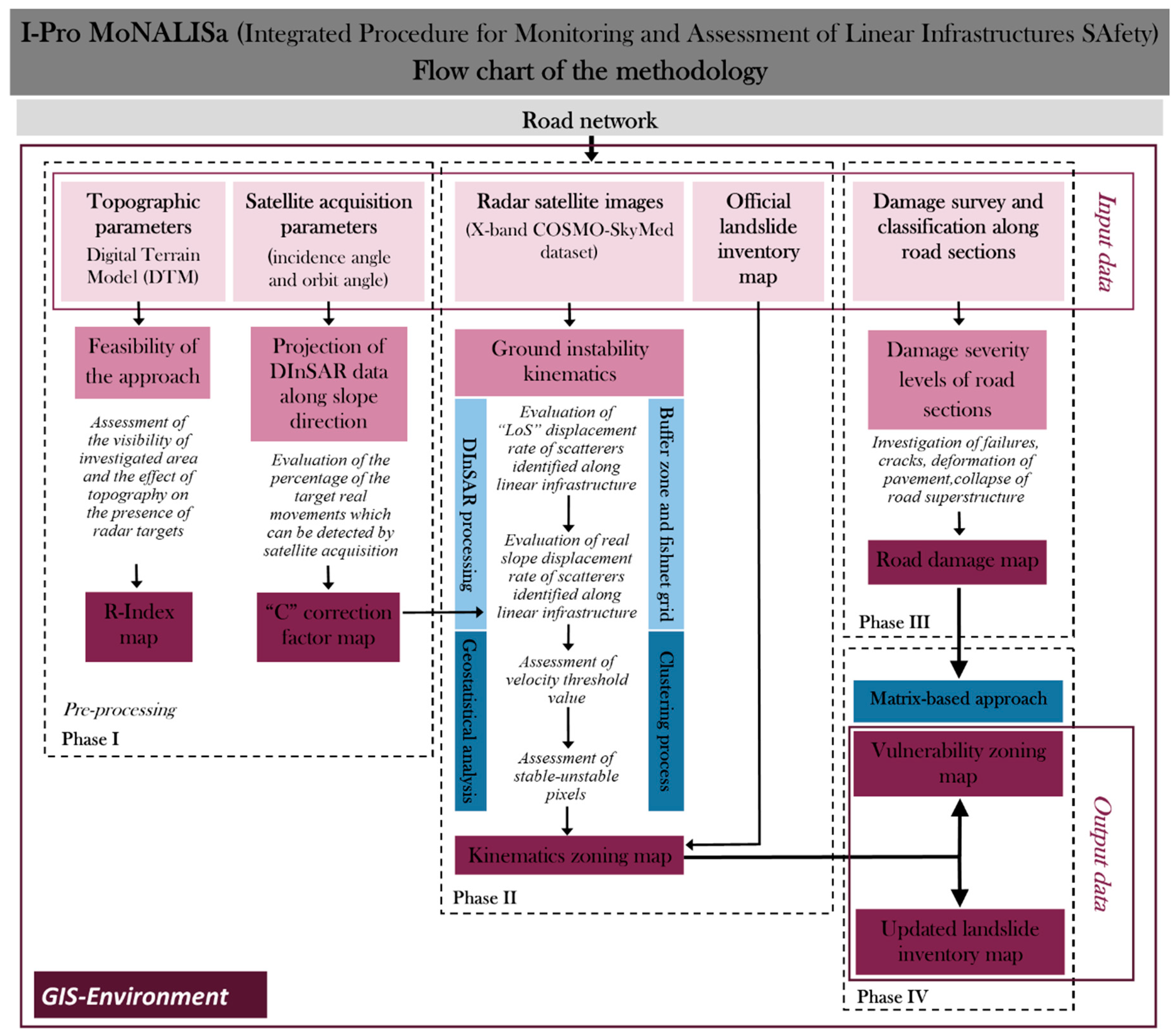
2. I-PRO MONALISA: A New Semiautomatic GIS Approach
- (a)
- DInSAR processing: SAR images dataset has been processed by means of Coherence Pixels Technique [44]. The analysis has been carried out by exploiting the Temporal Sublook Coherence (TSC) approach [45] for pixel selection. Such technique (CPT-TSC), based on the analysis of phase difference in interferometric stacks, identifies reliable scatterers by measuring their multitemporal coherence related to the phase stability. The interferograms, defined as the phase difference between two different acquisitions, are generated to further reduce decorrelation effects associated with possible coherence losses, typically due to topographic distortions, atmospheric patterns, and radiometric distortions. The exploitation of DInSAR methods, using multi-temporal stacks of SAR images, allows to remove all these contributions and to isolate the phase related to the displacement occurring between the two acquisitions. As a result, displacement annual rate and time series along ‘LoS’ direction of each identified scatterer have been obtained. Subsequently, the real slope displacement is calculated through the ratio between ‘LoS’ value and “C” correction factor;
- (b)
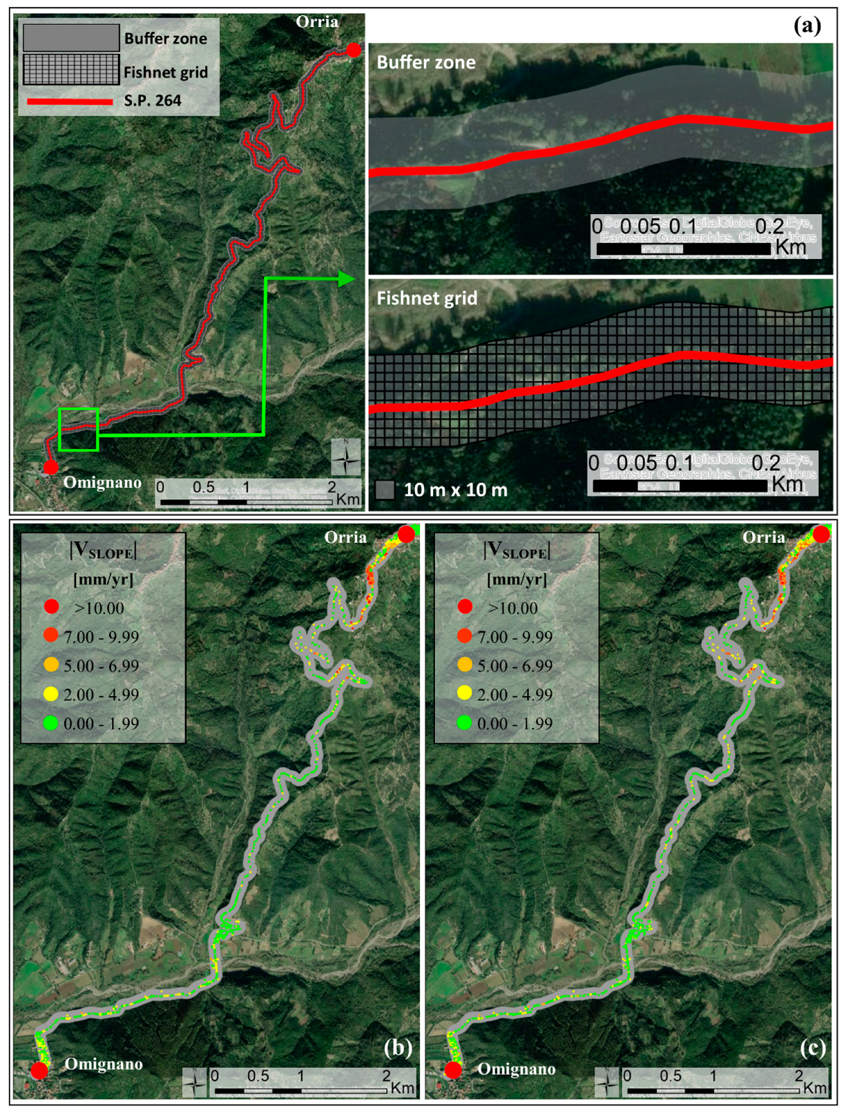
- creation of a “buffer” zone and a “fishnet” grid: A buffer zone has been created along the linear infrastructure defined from the available digital topographic map and only scatterers identified within such area have been considered to investigate landslides intensity also in the surrounding areas; furthermore, inside it a “fishnet” grid with pixel size depending on the spatial resolution of interferometric products, has been implemented;
- (c)
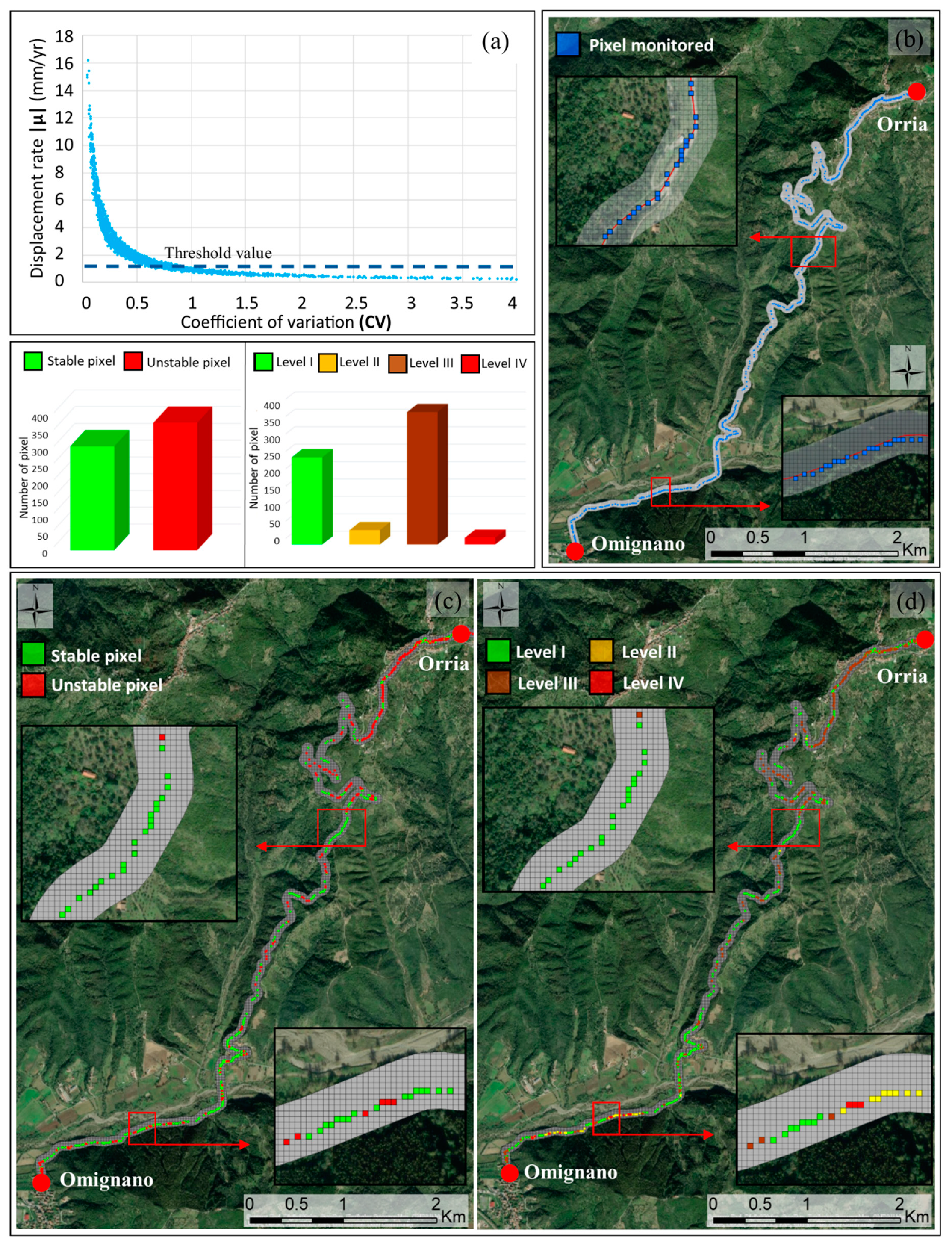
- geostatistical analysis: Post-processing of SAR data is a crucial step for the identification of the anomalous areas [46]. Aimed to discriminate stable from unstable targets, a displacement rate threshold has been assessed by calculating a coefficient of variation (CV) of each target, given by the ratio between the standard deviation σ and the mean velocity module |μ|, for all selected scatterers identified inside the buffer zone. From the analysis of the CV distribution it is possible to detect velocity threshold as a value for which standard deviation is higher than the mean velocity value [20]. The comparison of velocity threshold value with the movement rate of each radar target identified inside the fishnet grid provides scatterers which can be considered unstable;
- (d)
- cluster analysis: As for the optimization of the results, a clustering process is also very useful. DInSAR processing results, in fact, consist of a high amount of points related to a deformation measurement: Such post-processing allows to identify, within fishnet grid, possible “anomalous” areas where similar displacement rate values tend to be clustered, by defining an “Homogeneity Index” (HI) which is the ratio between the number of moving targets and the total number of targets within each pixel of fishnet. Only pixels of fishnet grid with at least the 50% of “moving” targets inside have been considered as unstable, thus obtaining a map of stable/unstable pixels [20];
- (e)
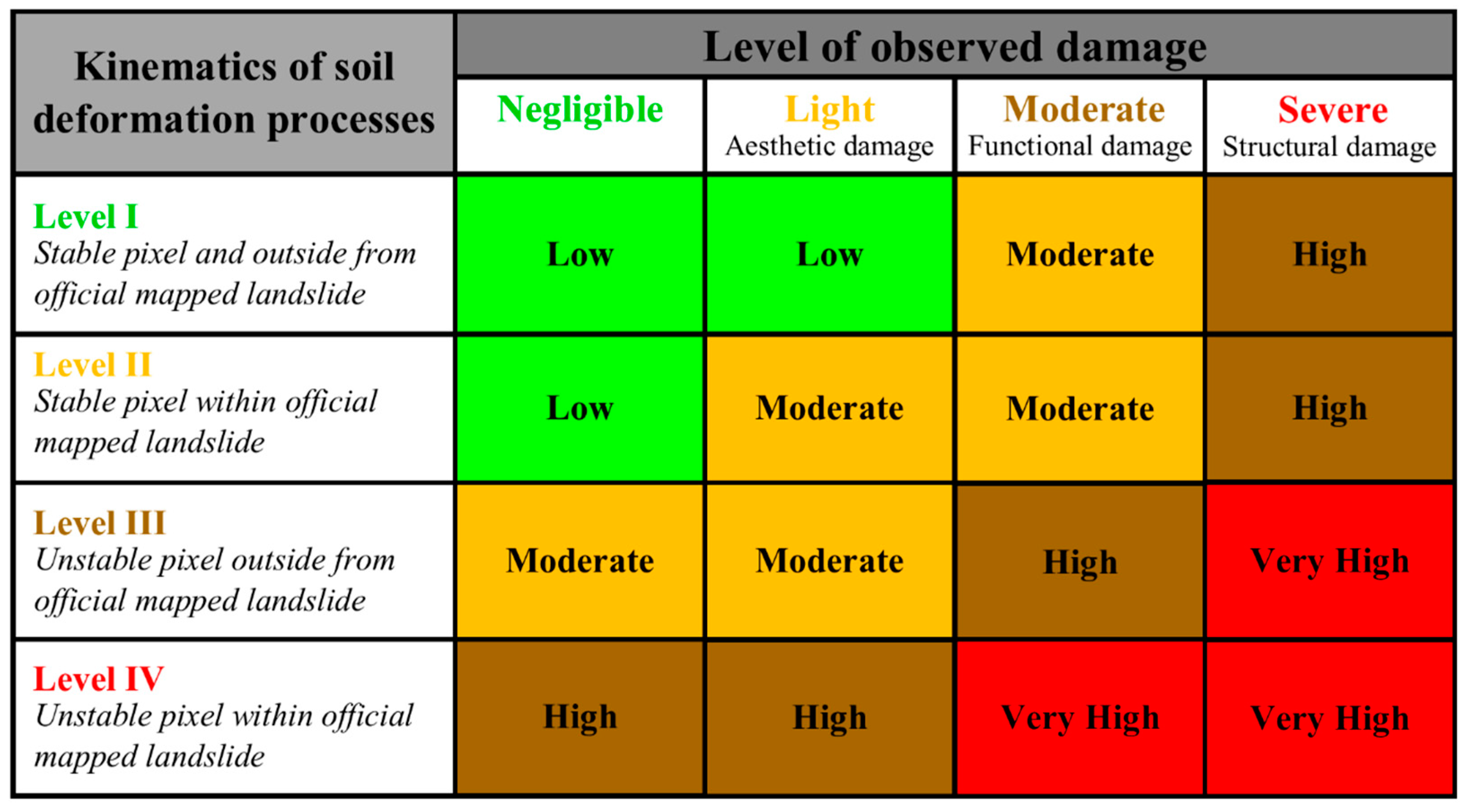
- definition of “kinematics” zoning map: Finally, the integration of existing landslides inventory map and results of “cluster” analysis permits to identify, using a colour-based coding, pixels along linear infrastructure showing different kinematics. Four different levels characterized by a growing critical behavior can be defined:
- -
- Level I (green color): Pixel stable and outside from the officially mapped landslide;
- -
- level II (yellow color): Pixel stable within the officially mapped landslide;
- -
- level III (orange color): Pixel unstable and outside from the officially mapped landslide;
- -
- level IV (red color): Pixel unstable and within the officially mapped landslide.
- -
- Negligible damage: No crack and deformation or isolated hairline cracks have been observed on pavement surface;
- -
- aesthetic (or light) damage: Limited small cracks, local roughness, and distortions occurred to road surface. The functionality of roads is not compromised and damage can be repaired, rapidly and at low cost;
- -
- Functional (moderate) damage: Diffuse cracking, severe deformations of pavement, possible partial collapse of superstructure. The functionality of the infrastructure is partially compromised and damage takes time and large resources to be fixed;
- -
- structural (or severe) damage: Structural failures, dangerous deformation, and total collapse of road superstructure occur. Transportation routes are severely or completely damaged and require extensive work to be rebuilt.
- -
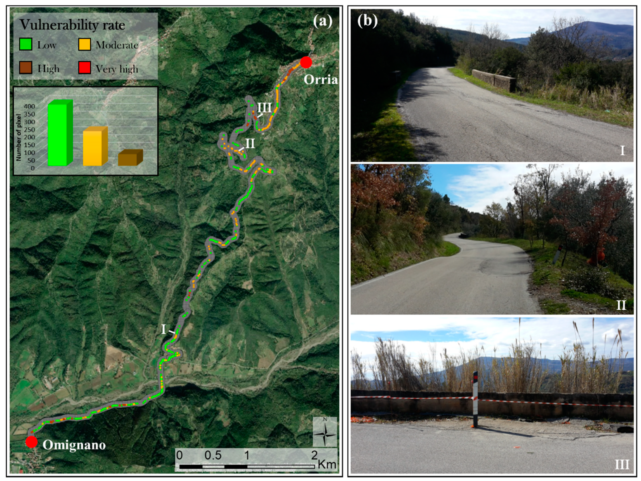
- “Low” vulnerability level: Acceptable. A periodical monitoring of ground kinematics and a control of in situ conditions can be recommended. No mitigation options need to be considered;
- -
- “Moderate” vulnerability level: May be tolerable. A periodical monitoring and controlling slope stability and in situ conditions with a higher frequency can be required and planning treatment options may be defined to maintain or reduce vulnerability;
- -
- “High” vulnerability level: A detailed investigation, planning, and implementation of measures to vulnerability reduction is required;
- -
- “Very High” vulnerability level: An extensive and detailed investigation and an expensive planning of stabilization measures are essential to reduce vulnerability to acceptable levels. Linear infrastructure could be useless.
3. The Case Study of “P.R. 264” Linear Infrastructure
4. Results
4.1. Assessment of Ground Instability Kinematics by Available Landslide Inventory Map and Satellite Interferometric Products
4.2. In Situ Damage Survey
4.3. Vulnerability Zoning Map
5. Discussion
6. Conclusions
Author Contributions
Funding
Acknowledgments
Conflicts of Interest
References
- Istituto di Ricerca per la Protezione Idrogeologica (IRPI), del Consiglio Nazionale delle Ricerche (CNR). Periodical Report about Landslide and Flood Hazard to Italian People; Institute for Environmental Protection and Research (ISPRA): Perugia, Italy, 2018. (In Italian)
- Martino, S.; Bozzano, F.; Caporossi, P.; D’Angiò, D.; Della Seta, M.; Esposito, C.; Fantini, A.; Fiorucci, M.; Giannini, L.M.; Iannucci, R.; et al. Impact of landslides on transportation routes during the 2016–2017 Central Italy seismic sequence. Landslides 2019, 16, 1221–1241. [Google Scholar] [CrossRef]
- Brownjohn, J.M. Structural health monitoring of civil infrastructure. Philos. Trans. R. Soc. Lond. Math. Phys. Eng. Sci. 2007, 365, 589–622. [Google Scholar] [CrossRef] [PubMed] [Green Version]
- Sousa, J.J.; Bastos, L. Multi-temporal SAR interferometry reveals acceleration of bridge sinking before collapse. Nat. Hazards Earth Syst. Sci. 2013, 13, 659–667. [Google Scholar] [CrossRef]
- Dragos, K.; Smarsly, K. Decentralized infrastructure health monitoring using embedded computing in wireless sensor networks. In Dynamic Response of Infrastructure to Environmentally Induced Loads; Springer: Cham, Switzerland, 2017; pp. 183–201. [Google Scholar]
- Fornaro, G.; Reale, D.; Verde, S. Potential of SAR for monitoring transportation infrastructures: An analysis with the multi-dimensional imaging technique. J. Geophys. Eng. 2012, 9, S1–S9. [Google Scholar] [CrossRef]
- Novellino, A.; Cigna, F.; Sowter, A.; Syafiudin, M.F.; Di Martire, D.; Ramondini, M.; Calcaterra, D. Intermittent small baseline subset (ISBAS). SAR analysis to monitor landslides in Costa della Gaveta, Southern Italy 2015. In Proceedings of the IEEE International Geoscience and Remote Sensing Symposium, IGARSS, Milan, Italy, 26–31 July 2015; pp. 3536–3539. [Google Scholar]
- Casagli, N.; Cigna, F.; Bianchini, S.; Hölbling, D.; Füreder, P.; Righini, G.; Del Conte, S.; Friedl, S.; Schneiderbauer, C.; Iasio, C.; et al. Landslide mapping and monitoring by using radar and optical remote sensing: Examples from the EC-FP7 project SAFER. Remote Sens. Appl. Soc. Environ. 2016, 4, 92–108. [Google Scholar] [CrossRef] [Green Version]
- Tomás, R.; Li, Z. Earth observations for geohazards: Present and future challenges. Remote Sens. 2017, 9, 194. [Google Scholar] [CrossRef] [Green Version]
- Zhang, Y.; Meng, X.; Jordan, C.; Novellino, A.; Dijkstra, T.; Chen, G. Investigating slow-moving landslides in the Zhouqu region of China using InSAR time series. Landslides 2018, 15, 1299–1315. [Google Scholar] [CrossRef]
- Costantini, M.; Zhu, M.; Huang, S.; Bai, S.; Cui, J.; Minati, F.; Vecchioli, F.; Jin, D.; Hu, Q. Automatic detection of building and infrastructure instabilities by spatial and temporal analysis of InSAR measurements. In Proceedings of the IGARSS 2018-2018 IEEE International Geoscience and Remote Sensing Symposium, Valencia, Spain, 22–27 July 2018; pp. 2224–2227. [Google Scholar]
- Pappalardo, G.; Mineo, S.; Angrisani, A.C.; Di Martire, D.; Calcaterra, D. Combining field data with infrared thermography and DInSAR surveys to evaluate the activity of landslides: The case study of Randazzo Landslide (NE Sicily). Landslides 2018, 15, 2173–2193. [Google Scholar] [CrossRef]
- Confuorto, P.; Di Martire, D.; Infante, D.; Novellino, A.; Papa, R.; Calcaterra, D.; Ramondini, M. Monitoring of remedial works performance on landslide-affected areas through ground- and satellite-based techniques. Catena 2019, 178, 77–89. [Google Scholar] [CrossRef]
- Pastor, J.L.; Tomás, R.; Lettieri, L.; Riquelme, A.; Cano, M.; Infante, D.; Ramondini, M.; Di Martire, D. Multi-Source Data Integration to Investigate a Deep-Seated Landslide Affecting a Bridge. Remote Sens. 2019, 11, 1878. [Google Scholar] [CrossRef] [Green Version]
- Wasowski, J.; Pisano, L. Long-term InSAR, borehole inclinometer, and rainfall records provide insight into the mechanism and activity patterns of an extremely slow urbanized landslide. Landslides 2019, 1–13. [Google Scholar] [CrossRef]
- Grebby, S.; Orynbassarova, E.; Sowter, A.; Gee, D.; Athab, A. Delineating ground deformation over the Tengiz oil field, Kazakhstan, using the Intermittent SBAS (ISBAS) DInSAR algorithm. Int. J. Appl. Earth Obs. Geoinf. 2019, 81, 37–46. [Google Scholar] [CrossRef]
- Gee, D.; Sowter, A.; Grebby, S.; de Lange, G.; Athab, A.; Marsh, S. National geohazards mapping in Europe: Interferometric analysis of the Netherlands. Eng. Geol. 2019, 256, 1–22. [Google Scholar] [CrossRef]
- Poreh, D.; Iodice, A.; Riccio, D.; Ruello, G. Railways’ stability observed in Campania (Italy) by InSAR data. Eur. J. Remote Sens. 2016, 49, 417–431. [Google Scholar] [CrossRef] [Green Version]
- Tessitore, S.; Di Martire, D.; Calcaterra, D.; Infante, D.; Ramondini, M.; Russo, G. Multitemporal synthetic aperture radar for bridges monitoring. In Remote Sensing Technologies and Applications in Urban Environments II; 104310C; International Society for Optics and Photonics: Bellingham, DC, USA, 2017; Volume 10431. [Google Scholar]
- Infante, D.; Di Martire, D.; Confuorto, P.; Tessitore, S.; Ramondini, M.; Calcaterra, D. Differential SAR interferometry technique for control of linear infrastructures affected by ground instability phenomena. Int. Arch. Photogramm. Remote Sens. Spat. Inf. Sci. ISPRS Arch. 2018, 42, 251–258. [Google Scholar] [CrossRef] [Green Version]
- Peduto, D.; Korff, M.; Nicodemo, G.; Marchese, A.; Ferlisi, S. Empirical fragility curves for settlement-affected buildings: Analysis of different intensity parameters for seven hundred masonry buildings in The Netherlands. Soils Found. 2019, 59, 380–397. [Google Scholar] [CrossRef]
- Infante, D.; Di Martire, D.; Confuorto, P.; Tessitore, S.; Tòmas, R.; Calcaterra, D.; Ramondini, M. Assessment of building behavior in slow-moving landslide-affected areas through DInSAR data and structural analysis. Eng. Struct. 2019, 199, 109638. [Google Scholar] [CrossRef] [Green Version]
- Milillo, P.; Giardina, G.; Perissin, D.; Milillo, G.; Coletta, A.; Terranova, C. Pre-Collapse Space Geodetic Observations of Critical Infrastructure: The Morandi Bridge, Genoa, Italy. Remote Sens. 2019, 11, 1403. [Google Scholar] [CrossRef] [Green Version]
- Tomás, R.; Pagán, J.I.; Navarro, J.A.; Cano, M.; Pastor, J.L.; Riquelme, A.; Cuevas-González, M.; Crosetto, M.; Barra, A.; Monserrat, O.; et al. Semi-automatic identification and pre-screening of geological–geotechnical deformational processes using persistent scatterer interferometry datasets. Remote Sens. 2019, 11, 1675. [Google Scholar]
- Fell, R. Landslide risk assessment and acceptable risk. Can. Geotech. J. 1994, 31, 261–272. [Google Scholar] [CrossRef]
- Leone, F.; Asté, J.P.; Leroi, E. Vulnerability assessment of elements exposed to mass-movement: Working toward a better risk perception. In Landslides; Senneset, K., Ed.; Balkema, A.A. Publishers: Rotterdam, The Netherlads, 1996; pp. 263–269. [Google Scholar]
- Amatruda, G.; Bonnard, C.; Castelli, M.; Forlati, F.; Giacomelli, L.; Morelli, M.; Paro, L.; Piana, F.; Pirulli, M.; Polino, R.; et al. A key approach: The imiriland project method. In Identification and Mitigation of Large Landslide Risks in Europe. Advances in Risk Assessment; Bonnard, C.H., Forlati, F., Scavia, C., Eds.; Balkema, A.A. Publishers: Rotterdam, The Netherlads, 2004; pp. 13–43. [Google Scholar]
- Van Westen, C.J. Geo-information tools for landslide risk assessment: An overview of recent developments. In Landslides: Evaluation and Stabilization, Proceedings of Ninth International Symposium on Landslides, Rio De Janeiro, Brazil, 28 June–2 July 2004; Lacerda, W., Ehrlich, M., Fontoura, S.A.B., Sayão, A.S.F., Eds.; Balkema, A.A. Publishers: Rotterdam, The Netherlads, 2004; Volume 1, pp. 39–56. [Google Scholar]
- Negulescu, C.; Foerster, E. Parametric studies and quantitative assessment of the vulnerability of a RC frame building exposed to differential settlements. Nat. Hazards Earth Syst. Sci. 2010, 10, 1781–1792. [Google Scholar] [CrossRef] [Green Version]
- Pitilakis, K.; Fotopoulou, S.D. Fragility curves for reinforced concrete buildings to seismically triggered slow-moving slides. Soil Dyn. Earthq. Eng. 2013, 48, 143–161. [Google Scholar] [CrossRef]
- Mavrouli, O.; Fotopoulou, S.; Pitilakis, K.M.; Zuccaro, G.; Corominas, J.; Santo, A.; Cacace, F.; De Gregorio, D.; Di Crescenzo, G.; Foerster, E.; et al. Vulnerability assessment for reinforced concrete buildings exposed to landslides. Bull. Eng. Geol. Environ. 2014, 73, 265–289. [Google Scholar] [CrossRef]
- Ferlisi, S.; Peduto, D.; Gullà, G.; Nicodemo, G.; Borrelli, L.; Fornaro, G. The use of DInSAR data for the analysis of building damage induced by slow-moving landslides. In Engineering Geology for Society and Territory—Landslide Processes; Lollino, G., Giordan, D., Crosta, G.B.J., Corominas, J., Azzam, R., Wasowski, J., Sciarra, N., Eds.; Springer International Publishing: Berlin, Germany, 2015; Volume 2, pp. 1835–1839. [Google Scholar]
- Peduto, D.; Nicodemo, G.; Maccabiani, J.; Ferlisi, S.; D’Angelo, R.; Marchese, A. Investigating the behaviour of buildings with different foundation types on soft soils: Two case studies in the Netherlands. Procedia Eng. 2016, 158, 529–534. [Google Scholar] [CrossRef] [Green Version]
- Del Soldato, M.; Bianchini, S.; Calcaterra, D.; De Vita, P.; Di Martire, D.; Tomás, R.; Casagli, N. A new approach for landslide-induced damage assessment. Geomat. Natl. Hazards Risk 2017, 8, 1524–1537. [Google Scholar] [CrossRef]
- Dai, F.C.; Lee, C.F.; Ngai, Y.Y. Landslide risk assessment and management: An overview. Eng. Geol. 2002, 64, 65–87. [Google Scholar] [CrossRef]
- Corominas, J.; van Westen, C.; Frattini, P.; Cascini, L.; Malet, J.P.; Fotopoulou, S.; Catani, F.; Van Den Eeckhaut, M.; Mavrouli, O.; Agliardi, F.; et al. Recommendations for the quantitative analysis of landslide risk. Bull. Eng. Geol. Environ. 2014, 73, 209–263. [Google Scholar] [CrossRef]
- Infante, D.; Confuorto, P.; Di Martire, D.; Ramondini, M.; Calcaterra, D. Use of DInSAR Data for Multi-level Vulnerability Assessment of Urban Settings Affected by Slow-moving and Intermittent Landslides. Procedia Eng. 2016, 158, 470–475. [Google Scholar] [CrossRef] [Green Version]
- Notti, D.; Davalillo, J.C.; Herrera, G.; Mora, O. Assessment of the performance of X-band satellite radar data for landslide mapping and monitoring: Upper Tena Valley case study. Nat. Hazards Earth Syst. Sci. 2010, 10, 1865–1875. [Google Scholar] [CrossRef]
- Notti, D.; Herrera, G.; Bianchini, S.; Meisina, C.; García-Davalillo, J.C.; Zucca, F. A methodology for improving landslide PSI data analysis. Int. J. Remote Sens. 2014, 35, 2186–2214. [Google Scholar]
- Colesanti, C.; Wasowski, J. Investigating landslides with spaceborne Synthetic Aperture Radar (SAR) interferometry. Eng. Geol. 2006, 88, 173–199. [Google Scholar] [CrossRef]
- Plank, S.; Singer, J.; Minet, C.; Thuro, K. Pre-survey suitability evaluation of the differential synthetic aperture radar interferometry method for landslide monitoring. Int. J. Remote Sens. 2012, 33, 6623–6637. [Google Scholar] [CrossRef]
- Bianchini, S.; Herrera, G.; Mateos, R.; Notti, D.; Garcia, I.; Mora, O.; Moretti, S. Landslide activity maps generation by means of persistent scatterer interferometry. Remote Sens. 2013, 5, 6198–6222. [Google Scholar] [CrossRef] [Green Version]
- Herrera, G.; Gutierrez, F.; García-Davalillo, J.C.; Guerrero, J.; Notti, D.; Galve, J.P.; Fernández-Merodo, J.; Cooksley, G. Multi-sensor advanced DInSAR monitoring of very slow landslides: The Tena Valley case study (Central Spanish Pyrenees). Remote Sens. Environ. 2013, 128, 31–43. [Google Scholar] [CrossRef]
- Mora, O.; Mallorquí, J.J.; Broquetas, A. Linear and nonlinear terrain deformation maps from a reduced set of interferometric SAR images. IEEE Trans. Geosci. Remote Sens. 2003, 41, 2243–2253. [Google Scholar] [CrossRef]
- Iglesias, R.; Mallorqui, J.J.; Monells, D.; Lopez-Martinez, C.; Fabregas, X.; Aguasca, A.; Gili, J.A.; Corominas, J. PSI Deformation Map Retrieval by means of Temporal Sublook Coherence on Reduced Sets of SAR Images. Remote Sens. 2015, 7, 530–563. [Google Scholar] [CrossRef] [Green Version]
- Meisina, C.; Zucca, F.; Notti, D.; Colombo, A.; Cucchi, A.; Savio, G.; Giannico, C.; Bianchi, M. Geological interpretation of PSInSAR data at regional scale. Sensors 2008, 8, 7469–7492. [Google Scholar] [CrossRef] [Green Version]
- Moulton, L.K. Tolerable Movement Criteria for Highway Bridges; Report No. Fhwa/Rd-85/107; Federal Highway Administration: Washington, DC, USA, 1985.
- Keller, S.; Atzl, A. Mapping natural hazard impacts on road infrastructure—the extreme precipitation in Baden-Württemberg, Germany, June 2013. Int. J. Disaster Risk Sci. 2014, 5, 227–241. [Google Scholar] [CrossRef] [Green Version]
- Cardinali, M.; Reichenbach, P.; Guzzetti, F.; Ardizzone, F.; Antonini, G.; Galli, M.; Cacciano, M.; Castellani, M.; Salvati, P. A geomorphological approach to the estimation of landslide hazards and risks in Umbria, Central Italy. In Natural Hazards and Earth System Science; Copernicus Publications on behalf of the European Geosciences Union: Göttingen, Germany, 2002; Volume 2, pp. 57–72. [Google Scholar]
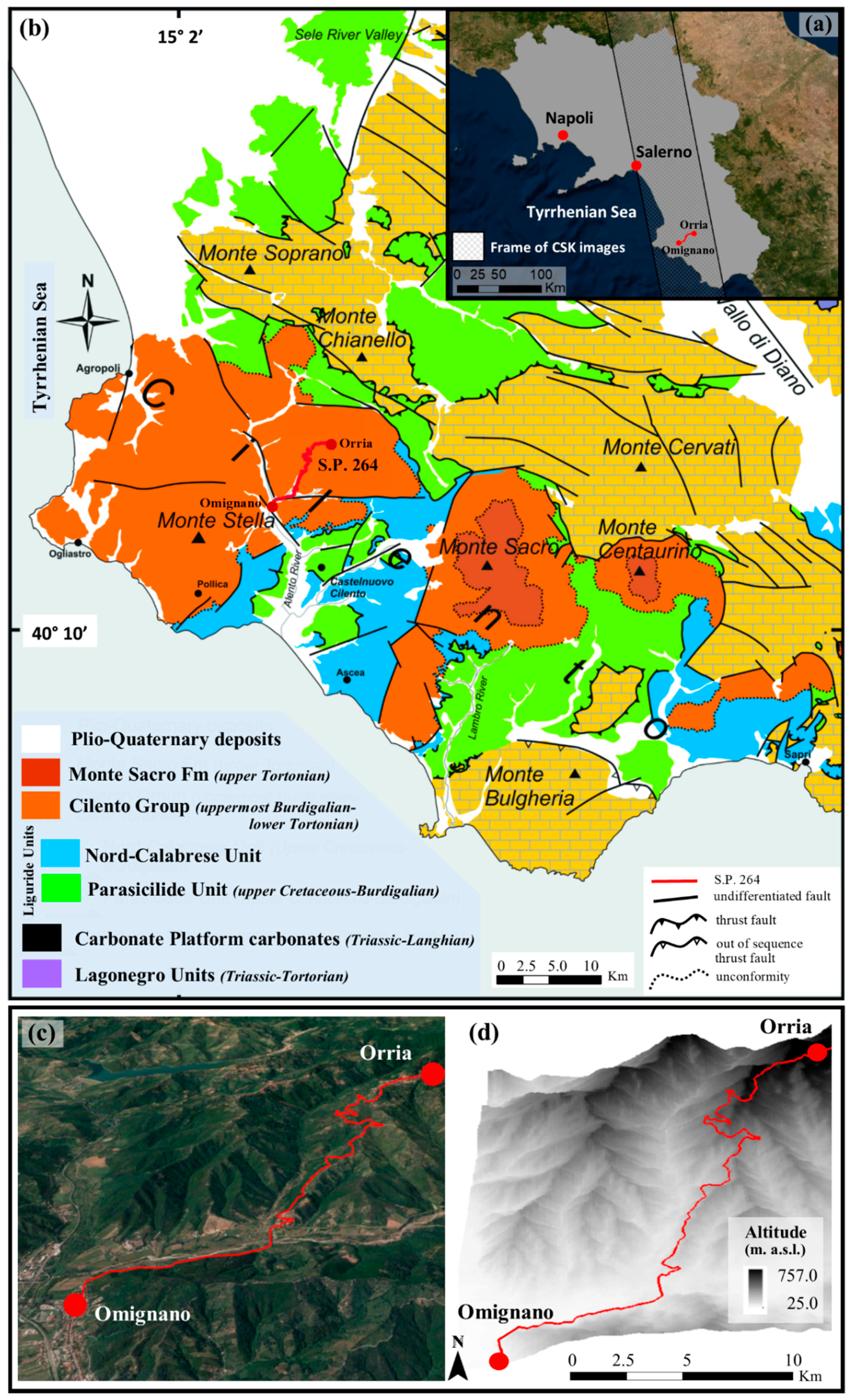
- D’Argenio, B.; Pescatore, T.; Scandone, P. Structural Pattern of the Campanian-Lucania Apennines. Structural model of Italy. Quad. Della Ric. Sci. 1975, 90, 313–327. (In Italian) [Google Scholar]
- Bonardi, G.; D’Argenio, B.; Perrone, V. Carta geologica dell’Appennino Meridionale. In Proceedings of the 74th Congresso della Società Geologica d’Italia, Sorrento, Italian, 13–17 September 1988. [Google Scholar]
- Vitale, S.; Ciarcia, S.; Mazzoli, S.; Zaghloul, M.N. Tectonic evolution of the ‘Liguride’ accretionary wedge in the Cilento area, southern Italy: A record of early Apennine geodynamics. J. Geodyn. 2011, 51, 25–36. [Google Scholar] [CrossRef] [Green Version]



| Satellite | COSMO-SkyMed (ASI Agency) |
|---|---|
| Microwave band | X |
| Acquisition mode | Ascending |
| Incidence angle (°) | 29.34 |
| Revisiting time (days) | 16 |
| Temporal span | 25 January 2012–01 January 2015 |
| Number of scenes | 52 |
| Cell resolution in azimuth and range (m) | 3 × 3 |
| Processing approach | CPT-TSC |
| PS density (PS/km2) | ~600 |
| Measurement precision: | |
| -linear velocity | ±1.5 mm/yr |
| -single displacement | ±4.0 mm |
| -geolocation (x,y,z) | ±1.5 m |
| Correction factor |C| | (0.0, +1.0) |
| V-SLOPE PS data velocity range (mm/year) | (−14.5, +3.8) |
| P.R. 264 Section Typology | Full-Benched/Cut and -Fill Road | |
|---|---|---|
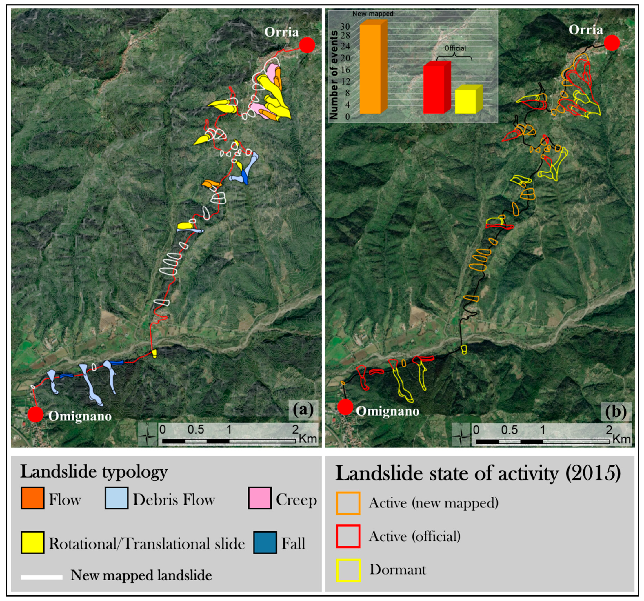
| Official mapped landslides HSP of South Campania River Basin Authority in 2012 | 24 Typology: 8 (debris flow) -8 (flow) - 4 (rotational- translational slide) - 2 (fall) - 2 (creep) State of activity: 22 (dormant) - 2 (active) | |
| Damage survey (November 2014–January 2015) | 54 road sections (180 pixels of fishnet grid) 32 (negligible) - 16 (light) – 6 (moderate) | |
| DInSAR analysis | Monitored pixels | 690 |
| Number of stable pixels Number of unstable pixels |Velocity threshold| = 2 mm/year | 310 380 | |
| Terrain kinematics (number of pixels) | 250 (level I) 41 (level II) 380 (level III) 19 (level IV) | |
| Vulnerability assessment | 393 pixels (low degree) 222 pixels (moderate degree) 75 pixels (high degree) | |
| Updated landslides inventory map (January 2015) | 30 new landslides - state of activity: active 24 official mapped landslides: -14 reactivations (dormant in 2012, active in 2015) -10 continuous state of activity (8 dormant and 2 active both in 2012 and in 2015) | |
© 2019 by the authors. Licensee MDPI, Basel, Switzerland. This article is an open access article distributed under the terms and conditions of the Creative Commons Attribution (CC BY) license (http://creativecommons.org/licenses/by/4.0/).
Share and Cite
Infante, D.; Di Martire, D.; Calcaterra, D.; Miele, P.; Scotto di Santolo, A.; Ramondini, M. Integrated Procedure for Monitoring and Assessment of Linear Infrastructures Safety (I-Pro MONALISA) Affected by Slope Instability. Appl. Sci. 2019, 9, 5535. https://doi.org/10.3390/app9245535
Infante D, Di Martire D, Calcaterra D, Miele P, Scotto di Santolo A, Ramondini M. Integrated Procedure for Monitoring and Assessment of Linear Infrastructures Safety (I-Pro MONALISA) Affected by Slope Instability. Applied Sciences. 2019; 9(24):5535. https://doi.org/10.3390/app9245535
Chicago/Turabian StyleInfante, Donato, Diego Di Martire, Domenico Calcaterra, Pietro Miele, Anna Scotto di Santolo, and Massimo Ramondini. 2019. "Integrated Procedure for Monitoring and Assessment of Linear Infrastructures Safety (I-Pro MONALISA) Affected by Slope Instability" Applied Sciences 9, no. 24: 5535. https://doi.org/10.3390/app9245535
APA StyleInfante, D., Di Martire, D., Calcaterra, D., Miele, P., Scotto di Santolo, A., & Ramondini, M. (2019). Integrated Procedure for Monitoring and Assessment of Linear Infrastructures Safety (I-Pro MONALISA) Affected by Slope Instability. Applied Sciences, 9(24), 5535. https://doi.org/10.3390/app9245535


