Abstract
Ocean temperatures increased during the 20th century and are predicted to continue to rise during the 21st century. Simultaneously, the extreme phenomena of shorter time ocean warming, known as Marine Heatwaves (MHWs), are also taking place. The present study used the Daily Optimum Interpolation Sea Surface Temperature (DOISST) v2.1 with a spatial resolution of 0.25˚. The time period of the DOISST data used in this study was from January 1, 1982 to December 31, 2020, and the region was 90° E–150° E and 16° S–16° N, which is divided into 11 Fishing Management Areas (FMAs). MHWs have a set of metrics derived from the SST data to describe the statistical characteristics of each event. To examine and quantify the influence of the Pacific Ocean and the Indian Ocean, we used the Niño 3.4 SST index and the Dipole Mode Index (DMI), respectively. Based on the data analysis, there has been an increase in the duration and frequency of the occurrence of MHWs in the study area, with the highest increase occurring in FMA 573, FMA 716, and FMA 711. Based on the severity, MHWs in Indonesia are dominated by category I, which is dominantly located in FMA 716, category II in FMA 573, category III with the center of events in FMA 771, and category IV with irregular spatial patterns.
1. Introduction
Marine heatwaves (MHWs) are the condition in which the ocean temperature becomes exceptionally high. They are defined using a relative threshold, usually the 90th or 99th percentile of the probability density function [1,2,3]. Several MHWs events have been observed in all ocean basins. Some of the most prominent events were in the Northwest Atlantic in 2012 [4], the Western Australia in 2012 [5], the North Pacific in 2013–2015 [6], the Northeast Pacific in 2019–2020 [7], and the Indian Ocean in 2015–2016 and 2019–2020 [8]. The factors that drive the occurrence of MHWs vary across each location and the time of the event. The MHW events in the Northwest Atlantic were dominated by local warming from the atmosphere [9]. Long-lasting MHWs in the tropical Indian Ocean were generated by downwelling Rossby waves [8]. Strong subsurface MHWs in the tropical western Pacific Ocean were controlled by an anomalous sea surface convergence and Ekman downwelling [10]. The most influential driver of MHWs is El Niño events [11], which occur when the ocean temperature in the Pacific becomes anomalously warm. ENSO oceanic teleconnection plays an essential role in distributing the excess heat from the central Pacific to other remote regions such as the Maritime Continent, Indian Ocean, and the extratropical Pacific [12].
MHWs have become increasingly prolonged and frequent, and the trend will likely become more prominent in the future, along with increasing ocean temperatures [1]. The spatial extent of the increasing MHW events projection will vary across the entire ocean. According to the projection based on the CMIP5 models, the largest MHW occurrence will be more likely to increase in tropical oceans, especially in the western tropical Pacific [10,13]. Indonesia is located between the Pacific Ocean and the Indian Ocean and acts as an oceanic passage between the two. Physical oceanic processes between the two basins, including their trend and variability, will pass through and affect the Indonesian seas. It has been found that the influence of ENSO in modulating MHWs in Indonesia is profound in the off south Java [14]. The trend in off west Sumatra and off south Java indicates that MHWs are becoming longer and more frequent [14,15], yet the MHW characteristics in the rest of the Indonesian region remain unexplored.
The Indonesian Sea is divided into 11 FMAs, which follow FAO’s provisions on Major Fishing Areas. There are three FMA regions starting with the number 57 (Eastern Indian Ocean) and eight FMA regions starting with the number 71 (Western Equatorial Pacific). The establishment of FMAs is based on statistical purposes to facilitate the management of fisheries in a broad sense that reflects the characteristics of the region and the resources contained therein. At least six of the Indonesian FMAs stand in the middle of the Coral Triangle [16]—the world’s hotspot for marine biodiversity. These coral reefs are the habitat of fish and other sea creatures. MHWs are known for their responsibility for coral bleaching events in many ocean basins [17,18]. They also lead to negative socioeconomics consequences, especially in the important fisheries sector [1]. During the 2016 (2020) MHWs, capture fisheries production decreased by 150 (300) thousand metric tons compared to the previous years [19]. Studying marine heatwaves in Indonesian FMAs is important to add valuable information for the management of fish, coral reefs, and other marine resources.
2. Materials and Methods
2.1. Data
The dataset used in this study was the Daily Optimum Interpolation Sea Surface Temperature record (DOISST) v2.1 [20,21]. This dataset contains daily data with a spatial resolution of 0.25°. The time period of the DOISST data used in this study was from January 1, 1982 to December 31, 2020, and the box region was 90° E–50° E and 16° S–16° N. The shape of the FMAs were obtained from the Marine Research Center, Ministry of Marine Affairs and Fisheries [22]. The spatial–temporal pattern of significant Sea Surface Temperature variability in Indonesia seas was determined in a previous study [23].
We used 11 FMAs in the Indonesian territory (Figure 1) as our area of interest (AOI). FMA 571 covers the Malacca Strait and the Andaman Sea; FMA 572 covers the Indian Ocean west of Sumatra and the Sunda Strait; FMA 573 covers the Indian Ocean south of Java to the south of Nusa Tenggara, the Sawu Sea, and the western part of the Timor Sea; FMA 711 covers the Karimata Strait, Natuna Sea, and the South China Sea; FMA 712 covers the Java Sea; FMA 713 covers the Makassar Strait, Bone Bay, Flores Sea, and the Bali Sea; FMA 714 covers Tolo Bay and the Banda Sea; FMA 715 covers Tomini Bay, the Maluku Sea, Halmahera Sea, Seram Sea, and Berau Bay; FMA 716 covers the Sulawesi Sea and the north of Halmahera Island; FMA 717 covers the Bay of Cendrawasih and the Pacific Ocean; and FMA 718 covers the Aru Sea, Arafura Sea, and the eastern part of the Timor Sea.
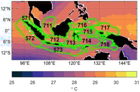
Figure 1.
Research map and FMAs–bounding polygon superimposed with the annual mean of SST. Shape resource: [22].
To examine and quantify the influence of the Pacific Ocean and the Indian Ocean, we used the Niño 3.4 SST index and the Dipole Mode Index (DMI), respectively, as the reference. The Niño 3.4 SST index and DMI were obtained from the Working Group of Surface Pressure, Physical Sciences Laboratory, National Oceanic and Atmospheric Administration (PSL NOAA) webpage (https://psl.noaa.gov/gcos_wgsp/Timeseries/Niño 3.434/ for Niño 3.4 SST index and https://psl.noaa.gov/gcos_wgsp/Timeseries/DMI/ for DMI, accessed on 1 March 2022).
2.2. MHWs Detection and Their Metrics
The detection of MHW events was performed using the following definition [2]: when the SST is above the 90th percentile threshold for at least five consecutive days. The 90th percentile threshold was calculated in every grid, and their values varied on each day of the year. The baseline period used for the SST climatology calculation was 31 years, from 1982 to 2012. Two consecutive MHW events with a gap of 2 days or less were considered part of a single MHW event.
MHWs have a set of metrics derived from the SST data to describe the statistical characteristics of each event. These metrics include intensity (mean, maximum, and cumulative); duration (individual, annual mean, and annual cumulative); and annual frequency of events. Following [11], we calculated the spatial distribution of the long-term mean and trend in the annual frequency of MHWs, annual MHW days (total number of days in a year that are part of MHWs), and annual cumulative intensity. We also calculated the spatially averaged temporal distribution of these metrics in each FMA.
MHWs can be classified into moderate, severe, strong, and extreme [3]. These categories are defined based on the multiplication of the difference between the threshold and the climatology (1x, 2x, 3x). The categories of MHWs can be calculated at any point in space and time. In this research, we present the spatial distribution of the long-term mean and trend of MHWs metrics. We also estimated the total area (in km2) occupied by each category in 11 FMAs, along with their temporal evolution.
To examine the influence of regional climate in modulating the occurrence of MHWs, the daily intensity of MHWs was cross-correlated with the Niño 3.4 SST index. The daily intensity of MHWs was down-sampled into monthly data to match the sampling rate of the climate indices. This was done to find the maximum correlation between the climate index and the occurrence of MHWs and their corresponding lag time.
3. Results
3.1. Mean and Trend of MHW Metrics
Various metrics that explain MHWs characteristics, such as the frequency of events, MHW days, and cumulative intensity, can be described in terms of trends or the difference between two time slices [11]. In general, there was an increase in the intensity, frequency, and duration of MHWs across FMAs from 1982 to 2020.
Indonesian waters experienced an average of 2 to 3 MHWs per year (Figure 2a). MHW events increased by more than 93% of Indonesian FMAs between two 18–year periods. The difference between the annual frequency of MHWs in 2003–2020 compared to 1982–1999 reached four annual events (Figure 2b). The areas with the highest increase in the occurrence of MHWs were FMA 716, FMA 715, and FMA 571. The annual frequency trends in these regions ranged from 0.7 to 1.2 events/decade (Table 1). This was equivalent to an increase of 2.73 to 4.68 annual events by the end of 2020. The years with the most MHWs were 1998, 2010, 2016, and 2020, which reached 7 to 9 events/year (Figure 2c).
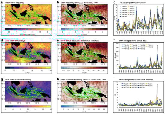
Figure 2.
Average mean, trend, and FMA of marine heatwaves metrics: frequency (a–c), annual days (d–f), and cumulative intensity (g–i).

Table 1.
Mean and trend of MHWs metrics: cumulative intensity, MHW days, and annual frequency. Red shading indicates the order of the highest trend values in each metric.
MHW days are the number of days in a year that are part of the MHWs event. The long-term average MHW days in the Indonesian sea were 15 to 40 days a year (Figure 2d). The regions that experienced the longest MHWs were FMA 711, FMA 573, and FMA 718 (Table 1). The difference in MHW days in 2003–2020 compared to 1982–1999 could reach more than 50 days, with the largest increase in the 716 FMA region (Figure 2e). The dominant years of MHWs accounted for the most MHW days, such as 1998, 2010, 2016, and 2020 (Figure 2f).
The average cumulative intensity of MHWs in Indonesian waters was 5 °C to 35 °C, with the highest accumulated intensity at FMA 573 (Figure 2g). The cumulative intensity difference in 2002–2020 compared to 1982–1999 could reach more than 25 °C, with the highest increase at FMA 573 (Figure 2h). The spatial average (Table 1) of the cumulative intensity increased, ranging from 0.7 to 4.2 °C/decade. The areas that experienced the most increase in cumulative intensity were FMA 573, FMA 711, and FMA 718. The years with the highest cumulative intensity (reaching over 30 °C) included 1998, 2010, 2016, and 2020 (Figure 2i). In 2016, the cumulative intensity of MHWs at FMA 573 hit an unprecedented 89 °C.
3.2. Categorization of MHWs in Indonesian FMAs
Figure 3 shows the temporal evolution of the area where MHWs occur in each category. It can be seen throughout the study period that category I MHWs dominated in Indonesia with a mean area coverage of (Figure 3a). This was followed by category II MHWs with a mean area coverage of (Figure 3b). The mean coverage area of category III MHWs was (Figure 3c). Meanwhile, the rarest occurrence of MHWs was category IV, with a mean coverage area of only (Figure 3d). The large difference in regional coverage between each category was caused by the higher threshold value (multiplication of the 90th percentile of SST). Extreme MHWs occur very rarely, but if they do occur, they have a tremendous negative impact on the environment (low–probability high–impact events).
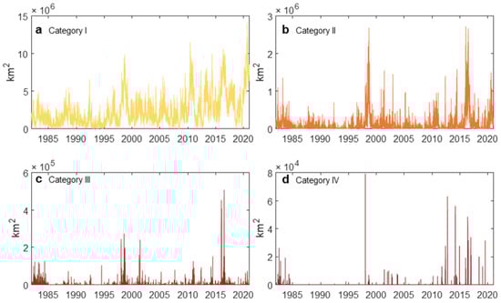
Figure 3.
MHWs coverage in study area sorted by category.
The trend in the coverage area of each category showed a significant increase. The difference in the average percentage of MHWs coverage area in 2003–2020 and 1982–1999 in category I was , category II , category III , and category IV . In addition, it can also be seen that the area affected by MHWs was greatly influenced by the ENSO phenomenon, especially in 1982–1983, 1997–1998, 2009–2010, 2015–2016, and 2019–2020. This result is in line with previous research conducted globally or regionally [11,14,24].
The occurrence of MHWs in each FMA was mostly detected in the years of ENSO decay. Figure 4 shows the average intensity of MHWs in the FMA 573, FMA 711, and FMA 716 regions from May to September. The average intensity of the MHWs is a function of the Niño 3.4 index, which was averaged from August to December of the previous year. In addition, color information shows the total duration of MHWs in the year that the average intensity of MHWs was calculated. Visualization of inter-year variability was carried out using the approach of a previous study [24]. In the three regions that were averaged, the increase in the incidence of MHWs almost always occurred in El Niño decay years, such as 1998, 2010, and 2016. Meanwhile, the incidence of MHWs associated with La Niña decay years was very small. In La Niña decay years, the mean intensity and total duration of MHWs were relatively lower. In addition, it was also found that in the last decade of the research data, a high increase in El Niño anomaly was unlikely to be needed to trigger an increase in the incidence of MHWs. For example, in 2019, it did not fall into the extreme El Niño category, but there was an extensive occurrence of MHWs in 2020 in the western Pacific region and the South China Sea.
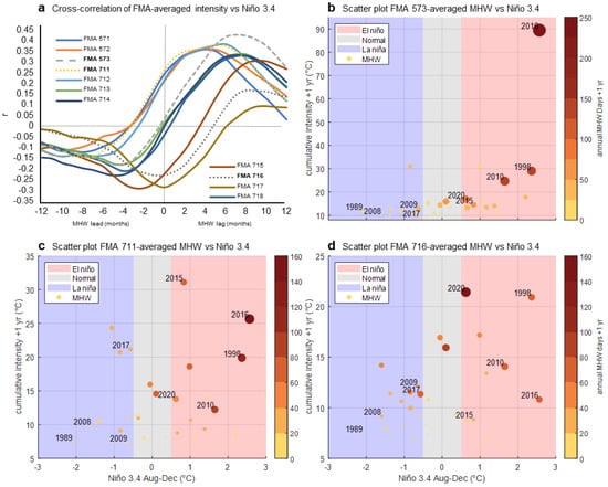
Figure 4.
Cross–correlation between Niño 3.4 and FMA averaged MHWs (a), scatter plot between FMA573 (b), FMA 711 (c), FMA 716 (d), averaged MHWs vs. Niño 3.4. Blue shades indicate negative phase (La Niña), red shades indicate positive phase (El Niño), and grey shades indicate neutral phase.
In FMA 573 (Figure 4b), the cumulative intensity of MHWs in from May to September ranged from 10 °C to 30 °C. ENSO decay was associated with an increase in the intensity and total duration of MHWs in the years of ENSO decay. In 2016, the cumulative intensity of MHWs from May to September reached 90 °C, and the total duration of MHWs in that year reached 250 days, or about 8 months. In 1998 the average intensity of MHWs from May to September reached 30 °C, with the total duration of MHWs in that year reaching 60 days. Likewise, in 2010, the average intensity of MHWs from May to September reached around 25 °C, with a total duration of 50 days. Meanwhile, in the La Niña decay years, there was no increase in the intensity of MHWs and no increase in the total duration of MHWs. In FMA 716 (Figure 4d) the same pattern also occurred, except in 2016, although it was preceded by an extreme El Niño event in the previous year. MHWs with the longest duration were detected in 2020, without being preceded by a strong El Niño event in 2019. The exception was in 2017, when there was an extensive MHW event, although in 2016 there was no strong El Niño event. However, in other years the same pattern remained; namely, more MHWs in El Niño decay years and MHWs in La Niña decay years tended to have a small intensity and very short duration. FMA 711 had mixed characteristics between the FMA 716 and FMA 573 regions. In 2020, there were no strong MHWs in FMA 573, but they occurred in FMA 711 due to the influence of the western Pacific region. In 2017, although there were MHWs in the Pacific, FMA 711 (Figure 4c) did not detect a similar event, rather like the MHWs event in FMA 573. In general, however, ENSO decay can be associated with an increase in MHWs. The cross-correlation between the spatially averaged MHWs against the Niño 3.4 SST index (Figure 4a) indicated a lag between ENSO activity and the occurrence of MHWs. The lag ranged from 2 to 10 months. The FMA 711 region experienced the shortest lag, ranging from 3 to 4 months. Meanwhile, the FMA 573 region experienced a longer lag, reaching 6 to 10 months. However, the largest correlation value was found in FMA 573 at a lag of 8 months. This means that the area off the southern coast of Java received the strongest influence from ENSO. The teleconnection between the Pacific Ocean and the Indian Ocean via the Indonesian Throughflow (ITF) is suggested to be the driver of MHWs. This is supported by previous studies revealing the strong negative correlation between ITF transport anomaly and ENSO variability. In FMA 573, there was a strong correlation between ITF transport and Niño 3.4. with a 6 to 8 month lag [25]. Using the ocean model result, it is also suggested that ITF lags behind ENSO by 8 to 9 months [26]. The correlation value between ITF is negative due to the southward flow direction. Observations from many in situ data also reveal that ITF in the outflow region lags behind ENSO by 4–8 months [27].
Marine heatwave events in the Indonesian FMA were also correlated with the Indian Ocean Dipole. Lead-lag correlation data suggest that MHWs had a positive correlation with DMI in the 2–8 and 8–12 months lag band (Figure 5a). These are the effects of ENSO to IOD that should be removed. Following [25,27] to remove the effect of ENSO with partial correlation, there are strong negative correlations between DMI and MHWs in every FMA (Figure 5b). In FMA 572, 573, 714, and FMA 718, there was no lag between MHW and IOD events, while in other FMAs, MHWs lagged behind IOD by 1 to 3 months. The correlation values are negative because warm water mass in the east side of Indian Ocean is prominent during the negative phase of IOD [28].
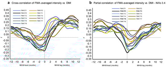
Figure 5.
Cross–correlation between DMI– and FMA–averaged MHWs (a), partial correlation between DMI– and FMA–averaged MHWs minus Niño 3.4 (b).
MHWs events with the longest duration or the highest frequency of occurrence in category I were clustered in the western part of the Pacific Ocean (Figure 6a) with a total duration of 6.3 years, according to 39 years of data. The areas with the most frequent occurrence of MHWs in category 1 within Indonesian FMAs were FMA 716, FMA 715, and FMA 573 with an area-averaged total duration of 4.97 years, 4.67 years, and 4.60 years, respectively. Category II MHWs events most frequently occurred in the southern region of Java (Figure 6b), with a total duration of up to 8 months out of 39 years of data. Due to the higher threshold, category II MHWs were about nine times rarer than category I MHWs. The areas with the most frequent category II MHWs events within Indonesian FMAs were FMA 573, FMA 711, and FMA 571, with area-averaged total durations of 5.00 months, 3.41 months, and 2.88 months, respectively. Category III MHWs were dominantly found in the South China Sea, with an accumulated duration of only 30 days out of 39 years of available data (Figure 6c). In the Indonesian FMAs area, category III MHWs were the most frequent in FMA 711, FMA 573, and FMA 572, with a total duration of only 6.84 days, 5.04 days, and 4.41 days, respectively. Category IV MHWs were very rare in the research areas. This is due to the high threshold used to define category IV MHWs. The longest category IV MHWs occurred in the Andaman Sea, northwest of FMA 571 and 572. In the FMAs themselves, category IV MHWs were almost non-existent. The average total duration of category IV MHWs at FMA 571, FMA 711, and FMA 573, respectively, was 1.84 days, 1.82 days, and 1.27 days, according to 39 years of data (Figure 6d). Category IV MHWs were usually the maximum intensity of an MHW event lasting only one or two days with a narrow coverage area.
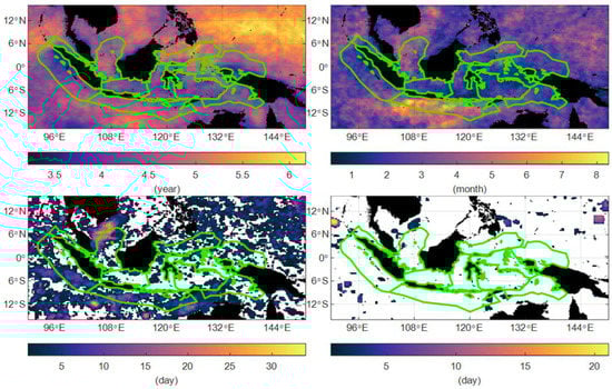
Figure 6.
Total duration of MHWs throughout research period sorted by category.
4. Discussion
Several previous studies [8,11,14,15,29,30] detected an increase in the frequency of the occurrence and duration of MHWs in various regions. This increase is projected to continue in the 21st century. One of the locations with the highest increase in the frequency of occurrence and duration of MHWs is in tropical ocean areas [8,13,30], including Indonesia. Research on the trends and variability of MHWs in Indonesia can be used as a reference to determine the characteristics of the occurrence of MHWs over the last four decades, as well as the dominant pattern and the main factors causing the occurrence of MHWs.
Across the study area, the duration and frequency of the occurrence of MHWs increased significantly. The biggest increase was in the areas of FMA 716, FMA 573, and FMA 711. The accumulated annual duration in FMA 716 increased by 24 days per decade, FMA 573 by 20 days per decade, and FMA 711 by 14 days per decade, which is equivalent to an increase of 50 to 100 days of MHWs by the end of 2020 compared to 1982. The frequency of the occurrence of MHWs in FMA 716 increased by 1.6 annual events per decade, FMA 573 by 0.8 annual events per decade, and FMA 711 by 1.4 annual events per decade. This can be interpreted as an increase in the number of MHWs by 3 to 6 annual events by the end of 2020 compared to 1982.
The role of ENSO and IOD is important in driving MHW events. ITF transport that moves warm water masses from the Pacific Ocean to the Indian Ocean is affected by these regional climate variabilities by the same phase as the MHWs event. There are three MHWs hotspots in the Indonesian waters; the off south Java region (FMA 573); the Celebes Sea (FMA 716) as the extension of the western Pacific Ocean; and the Karimata Strait (FMA 711) as the extension of South China Sea. These regions contain abundant, albeit vulnerable, marine ecosystem and fisheries potential. In fact, the mortalities of the marine ecosystem caused by MHWs have been observed in all ocean basins [18]. Moderate-to-extreme MHWs events are very dangerous to temperature-sensitive marine organisms. What has been observed globally is potentially leading to severe coral bleaching and mortality in Indonesian FMA [17,18,31]. A shift in temperature could also potentially impact capture fisheries production, eventually leading to economic consequences such as the decrease in production in 2016 and 2020 [19].
5. Conclusions
There was an increase in the duration and frequency of the occurrence of MHWs in the study area, with the highest increase occurring in FMA 573, FMA 716, and FMA 711. Based on the severity, MHWs in Indonesia are dominated by category I, which is dominantly located in FMA 716, category II in FMA 573, category III with the center of events in FMA 771, and category IV with irregular spatial patterns. Each year, MHW events can be associated with ENSO events in the previous year. The largest epicenter of the correlation between ENSO and MHWs is FMA 573, off the southern coast of Java.
Author Contributions
Conceptualization, A.D.H. and A.T.; methodology, A.D.H.; data processing, A.D.H.; formal analysis, A.D.H., A.T., and N.S.N.; writing—original draft preparation, A.D.H. and A.T.; writing—review and editing, A.T., N.S.N., and M.R.P.; visualization, A.D.H.; supervision, A.T., N.S.N., and M.R.P.; funding acquisition, N.S.N. All authors have read and agreed to the published version of the manuscript.
Funding
The Indonesian Ministry of Education, Culture, Research and Technology (Kemendikbudristek) supported this research under the research program of Penelitian Dasar Unggulan Perguruan Tinggi (PDUPT) 2022 (Research Grand Contract No. 187/E5/PG.02.00.PT/2022). A.T. and M.R.P. were funded by Research, Community Service and Innovation (PPMI 2021–2022, Bandung Institute of Technology). A.D.H. was also partially supported by the project titled “Marine Science & Technology Cooperation between Korea and Indonesia (20180319)”, which was funded by the Ministry of Oceans and Fisheries, Korea.
Institutional Review Board Statement
Not applicable.
Informed Consent Statement
Not applicable.
Data Availability Statement
All data that support the results of this study are included within the article.
Acknowledgments
We would like to gratefully acknowledge the DOISST v2.1 data support from NOAA.
Conflicts of Interest
The authors declare no conflict of interest.
References
- Collins, M.M.; Sutherland, M.; Bouwer, L.; Cheong, S.-M.; Frölicher, T.; Des Combes, H.J.; Roxy, M.K.; Losada, I.; McInnes, K.; Ratter, B.; et al. Extremes, Abrupt Changes and Managing Risks. In IPCC Special Report on the Ocean and Cryosphere in a Changing Climate; Pörtner, H.-O., Roberts, D.C., Masson-Delmotte, V., Zhai, M.T.P., Poloczanska, E., Mintenbeck, K., Alegría, A., Nicolai, M., Okem, A., Petzold, J., et al., Eds.; IPCC: Geneva, Switzerland, 2019; Available online: https://www.ipcc.ch/site/assets/uploads/sites/3/2019/11/10_SROCC_Ch06_FINAL.pdf (accessed on 15 October 2021).
- Hobday, A.J.; Alexander, L.V.; Perkins, S.E.; Smale, D.A.; Straub, S.C.; Oliver, E.C.J.; Benthuysen, J.A.; Burrows, M.T.; Donat, M.G.; Feng, M.; et al. A hierarchical approach to defining marine heatwaves. Prog. Oceanogr. 2016, 141, 227–238. [Google Scholar] [CrossRef]
- Hobday, A.J.; Oliver, E.C.J.; Gupta, A.S.; Benthuysen, J.A.; Burrows, M.T.; Donat, M.G.; Holbrook, N.J.; Moore, P.J.; Thomsen, M.S.; Wernberg, T.; et al. Categorizing and Naming Marine Heatwaves. Oceanography 2018, 31, 162–173. [Google Scholar] [CrossRef]
- Mills, K.E.; Pershing, A.J.; Brown, C.J.; Chen, Y.; Chiang, F.-S.; Holland, D.S.; Lehuta, S.; Nye, J.A.; Sun, J.C.; Thomas, A.C.; et al. Fisheries Management in a Changing Climate: Lessons from the 2012 Ocean Heat Wave in the Northwest Atlantic. Oceanography 2013, 26, 191–195. [Google Scholar] [CrossRef]
- Pearce, A.F.; Feng, M. The rise and fall of the “marine heat wave” off Western Australia during the summer of 2010/2011. J. Mar. Syst. 2013, 111–112, 139–156. [Google Scholar] [CrossRef]
- Bond, N.A.; Cronin, M.F.; Freeland, H.; Mantua, N. Causes and impacts of the 2014 warm anomaly in the NE Pacific. Geophys. Res. Lett. 2015, 42, 3414–3420. [Google Scholar] [CrossRef]
- Chen, Z.; Shi, J.; Liu, Q.; Chen, H.; Li, C. A persistent and intense marine heatwave in the Northeast Pacific during 2019–2020. Geophys. Res. Lett. 2021, 48, e2021GL093239. [Google Scholar] [CrossRef]
- Zhang, Y.; Du, Y.; Feng, M.; Hu, S. Long-lasting marine heatwaves instigated by ocean planetary waves in the tropical Indian Ocean during 2015–2016 and 2019–2020. Geophys. Res. Lett. 2021, 48, e2021GL095350. [Google Scholar] [CrossRef]
- Chen, K.; Gawarkiewicz, G.G.; Lentz, S.J.; Bane, J.M. Diagnosing the warming of the northeastern U.S. coastal ocean in 2012: A linkage between the atmospheric jet stream variability and ocean response. J. Geophys. Res. Ocean. 2014, 119, 218–227. [Google Scholar] [CrossRef]
- Hu, S.; Li, S.; Zhang, Y.; Guan, C.; Du, Y.; Feng, M.; Ando, K.; Wang, F.; Schiller, A.; Hu, D. Observed strong subsurface marine heatwaves in the tropical western Pacific Ocean. Environ. Res. Lett. 2021, 16, 104024. [Google Scholar] [CrossRef]
- Oliver, E.C.J.; Donat, M.G.; Burrows, M.T.; Moore, P.J.; Smale, D.A.; Alexander, L.V.; Benthuysen, J.A.; Feng, M.; Gupta, A.S.; Hobday, A.J.; et al. Longer and more frequent marine heatwaves over the past century. Nat. Commun. 2018, 9, 1324. [Google Scholar] [CrossRef]
- Sprintall, J.; Cravatte, S.; Dewitte, B.; Du, Y.; Gupta, A.S. ENSO Oceanic Teleconnections. In El Niño Southern Oscillation in a Changing Climate; McPhaden, M., Santoso, A., Cai, W., Eds.; Wiley: Hoboken, NJ, USA, 2020. [Google Scholar] [CrossRef]
- Frölicher, T.L.; Fischer, E.M.; Gruber, N. Marine heatwaves under global warming. Nature 2018, 560, 360–364. [Google Scholar] [CrossRef] [PubMed]
- Iskandar, M.R.; Ismail, M.F.A.; Arifin, T.; Chandra, H. Marine heatwaves of sea surface temperature off south Java. Heliyon 2021, 7, e08618. [Google Scholar] [CrossRef] [PubMed]
- Ismail, M.F.A. Characteristics of Marine Heatwaves off West Sumatra Derived from High-Resolution Satellite Data. J. Hunan Univ. Nat. Sci. 2021, 48, 130–136. [Google Scholar]
- Veron, J.C.E.; DeVantier, L.M.; Turak, E.; Green, A.L.; Kininmonth, S.; Stafford-Smith, M.; Peterson, N. The Coral Triangle. In Coral Reefs: An Ecosystem in Transition; Dubinsky, Z., Stambler, N., Eds.; Springer: Dordrecht, The Netherlands, 2011. [Google Scholar] [CrossRef]
- Hughes, T.P.; Kerry, J.T.; Álvarez-Noriega, M.; Álvarez-Romero, J.G.; Anderson, K.D.; Baird, A.H.; Babcock, R.C.; Beger, M.; Bellwood, D.R.; Berkelmans, R.; et al. Global warming and recurrent mass bleaching of corals. Nature 2017, 543, 373–377. [Google Scholar] [CrossRef]
- Hughes, T.P.; Anderson, K.D.; Connolly, S.R.; Heron, S.F.; Kerry, J.T.; Lough, J.M.; Baird, A.H.; Baum, J.K.; Berumen, M.L.; Bridge, T.C.; et al. Spatial and temporal patterns of mass bleaching of corals in the Anthropocene. Science 2018, 359, 80–83. [Google Scholar] [CrossRef]
- World Bank. Capture Fisheries Production (Metric Tons)—Indonesia. 2020. Available online: https://data.worldbank.org/indicator/ER.FSH.CAPT.MT?end=2020&locations=ID&start=2010 (accessed on 16 November 2022).
- Huang, B.; Liu, C.; Banzon, V.; Freeman, E.; Graham, G.; Hankins, B.; Smith, T.; Zhang, H.-M. Improvements of the Daily Optimum Interpolation Sea Surface Temperature (DOISST) Version 2.1. J. Clim. 2021, 34, 2923–2939. [Google Scholar] [CrossRef]
- Reynolds, R.W.; Smith, T.M.; Liu, C.; Chelton, D.B.; Casey, K.S.; Schlax, M.G. Daily High-Resolution-Blended Analyses for Sea Surface Temperature. J. Clim. 2007, 20, 5473–5496. [Google Scholar] [CrossRef]
- Pusat Riset Kelautan. Indonesia Fishing Management Area. 2013. Available online: http://pusriskel.litbang.kkp.go.id/index.php/en/data/perairan-indonesia/category/70-shape-file-laut-indonesia?download=590%3Awpp-juni-2011 (accessed on 26 May 2022).
- Habibullah, A.D.; Tarya, A. Sea surface temperature variability in Indonesia and its relation to regional climate indices. IOP Conf. Ser. Earth Environ. Sci. 2021, 925, 012008. [Google Scholar] [CrossRef]
- Tan, H.-J.; Cai, R.-S.; Wu, R.-G. Summer marine heatwaves in the South China Sea: Trend, variability and possible causes. Adv. Clim. Chang. Res. 2020, 13, 323–332. [Google Scholar] [CrossRef]
- Liu, Q.-Y.; Feng, M.; Wang, D.; Wijffels, S. Interannual variability of the Indonesian Throughflow transport: A revisit based on 30 year expendable bathythermograph data. J. Geophys. Res. Oceans 2015, 120, 8270–8282. [Google Scholar] [CrossRef]
- England, M.H.; Huang, F. On the Interannual Variability of the Indonesian Throughflow and Its Linkage with ENSO. J. Clim. 2005, 18, 1435–1444. [Google Scholar] [CrossRef]
- Li, M.; Gordon, A.L.; Gruenburg, L.K.; Wei, J.; Yang, S. Interannual to Decadal Response of the Indonesian Throughflow Vertical Profile to Indo-Pacific Forcing. Geophys. Res. Lett. 2020, 47, e2020GL087679. [Google Scholar] [CrossRef]
- Saji, N.H.; Goswami, B.N.; Vinayachandran, P.N.; Yamagata, T. A dipole mode in the tropical Indian Ocean. Nature 1999, 401, 360–363. [Google Scholar] [CrossRef]
- Mohamed, B.; Nagy, H.; Ibrahim, O. Spatiotemporal Variability and Trends of Marine Heat Waves in the Red Sea over 38 Years. J. Mar. Sci. Eng. 2021, 9, 842. [Google Scholar] [CrossRef]
- Smale, D.A.; Wernberg, T.; Oliver, E.C.J.; Thomsen, M.; Harvey, B.P.; Straub, S.C.; Burrows, M.T.; Alexander, L.V.; Benthuysen, J.A.; Donat, M.G.; et al. Marine heatwaves threaten global biodiversity and the provision of ecosystem services. Nat. Clim. Chang. 2019, 9, 306–312. [Google Scholar] [CrossRef]
- H Garrabou, J.; Gómez-Gras, D.; Medrano, A.; Cerrano, C.; Ponti, M.; Schlegel, R.; Bensoussan, N.; Turicchia, E.; Sini, M.; Gerovasileiou, V.; et al. Marine heatwaves drive recurrent mass mortalities in the Mediterranean Sea. Glob. Chang. Biol. 2022, 28, 5708–5725. [Google Scholar] [CrossRef] [PubMed]


Disclaimer/Publisher’s Note: The statements, opinions and data contained in all publications are solely those of the individual author(s) and contributor(s) and not of MDPI and/or the editor(s). MDPI and/or the editor(s) disclaim responsibility for any injury to people or property resulting from any ideas, methods, instructions or products referred to in the content. |
© 2023 by the authors. Licensee MDPI, Basel, Switzerland. This article is an open access article distributed under the terms and conditions of the Creative Commons Attribution (CC BY) license (https://creativecommons.org/licenses/by/4.0/).