Article

Submarine Slides and Their Influence on Gas Hydrate and Shallow Gas in the Pearl River Mouth Basin

1
State Key Laboratory of Natural Gas Hydrate, Beijing 100028, China
2
Laboratory for Marine Mineral Resources, Qingdao Marine Science and Technology Center, Qingdao 266237, China
3
Frontiers Science Center for Deep Ocean Multispheres and Earth System, Key Lab of Submarine Geosciences and Prospecting Techniques, MOE and College of Marine Geosciences, Ocean University of China, Qingdao 266100, China
4
China National Offshore Oil Corporation (CNOOC) Research Institute Co., Ltd., Beijing 100028, China
5
CNOOC China Limited, Shenzhen Branch, Shenzhen 518054, China
6
Yantai Center of Coastal Zone Geological Survey, China Geological Survey, Yantai 264000, China
*
Author to whom correspondence should be addressed.
J. Mar. Sci. Eng. 2025, 13(2), 308; https://doi.org/10.3390/jmse13020308
Submission received: 5 January 2025 / Revised: 24 January 2025 / Accepted: 27 January 2025 / Published: 7 February 2025
(This article belongs to the Special Issue Marine Geohazards: Characterization to Prediction)

Abstract

:
Submarine slides, gas hydrates, shallow gas, and volcanoes considered to be potential geohazards have been well delineated using three-dimensional (3D) seismic data and well log data in the Pearl River Mouth Basin, South China Sea. Seismic characteristics, distribution maps, and controlling factors of these geohazards have been well analyzed showing the influence of regional tectonics and sedimentary processes. Recently, shallow gas and gas hydrates are confirmed by drilling expeditions, which are considered important unconventional resources. Moreover, the mapped features of various geohazards show the spatial overlays and that they are connected each other. To delineate well the relationships between gas hydrates, shallow gas, and the potential geological features such as submarine slides, gas chimneys, faults, and volcanoes, the seismic attributes and interpretations are displayed using 3D seismic data to show the interplay between them. Gas hydrates and shallow gas occur and are widely distributed above sills, volcanoes, gas chimneys, and faults within the submarine slides and migrating canyon because large amount of hydrocarbon gas can migrate from the deep layer to the shallow layer along different pathways. This study aims to show the correlation among various geological bodies and their effects on shallow gas and gas hydrate distributions.

1. Introduction

The formation and dissolution of gas hydrates, the occurrence of shallow gas, earthquake, and so on have been considered to be the potential factors for triggering slope stability or submarine landslides for a long time [1,2,3,4,5,6]. Numerous studies show that sea level changes, the increase in bottom water temperature, and tectonic activities may lead to the dissolution of gas hydrate, release a large amount of gas, cause seafloor instability and trigger submarine landslides [1,7]. The relationship between slope instability versus the dissolution of gas hydrates, submarine landslides, and climate change has progressed slowly due to the lack of evidence of pressure and thermal disturbances.
In recent years, a large amount of high-resolution three-dimensional (3D) seismic data, well log data, and core samples have been used to delineate gas hydrate distribution and submarine landslides or mass transport deposits (MTDs) in the world’s oceans (Figure 1). Large-scale submarine landslides and gas hydrates have been developed simultaneously in many basins (Figure 1). Free gas-bearing layers are mostly trapped below the erosion of landslide areas showing enhanced reflections in the seismic profile. For example, in the Storegga submarine slide, Norway, the gas trapped in the lower strata migrates upward along polygonal faults and gas chimneys and accumulates at the low-permeability debris flow formed by glaciers [2,3]. The cold seep systems are formed at the strong seafloor leakage area, which are caused by the fluids’ migration along the sand-rich layer, especially at the pinch-out of the base of the gas hydrate stability zone (BGHSZ). Large quantities of fluid release may be caused by the decomposition of gas hydrates near the BGHSZ [8,9,10].
Many factors have been related to submarine slides, while the influence of gas hydrates should be different at certain water depths and different strata. Submarine slides have been discovered above the erosion surface in the Mediterranean Sea. Fluids or gases migrate upward along faults and erosion surfaces and are partially trapped at the base of the slide surface. Submarine slides are related to fluid migrations because overpressure formed by buoyancy reduces the effective stress and makes the continental slope unstable [11]. The numerical simulation shows that the overpressure can cause fluid to migrate in a lateral direction, leading to the Hinlopen landslide [12]. Pipe structures developed from the BGHSZ are found at the head of the submarine slide, which connect the gas-bearing layer to the shallow permeable strata. Fluids can migrate vertically, then laterally along the pipes triggering the submarine slide [12]. Therefore, local overpressure caused by hydrocarbon accumulation is an important factor in triggering submarine landslides.
There are two triggering mechanisms for submarine slides which are related to gas hydrate dissolution. One is related to the shifts of the BGHSZ. When the BGHSZ moves upward, gas hydrates will dissolve and release a large amount of gas and water near the bottom simulating reflector (BSR). The liquefaction of sediments due to gas hydrate dissolution may cause the lateral sliding of the gas hydrate-bearing layer together with the landslide. The other is that a large amount of gas can migrate to the slide surface under buoyancy and is trapped below the BGHSZ. Changes of temperature and pressure will lead to upward and downward adjustments of the BGHSZ, which will cause local gas recycling at the interface between gas hydrates and free gas [13,14]. Therefore, the fluids affecting landslides may be either deep fluids or gas hydrate dissolution. The episodic fluid release will generate overpressure, trigger landslides in the continental margin, and form large-scale cold seeps [8,10,15,16].
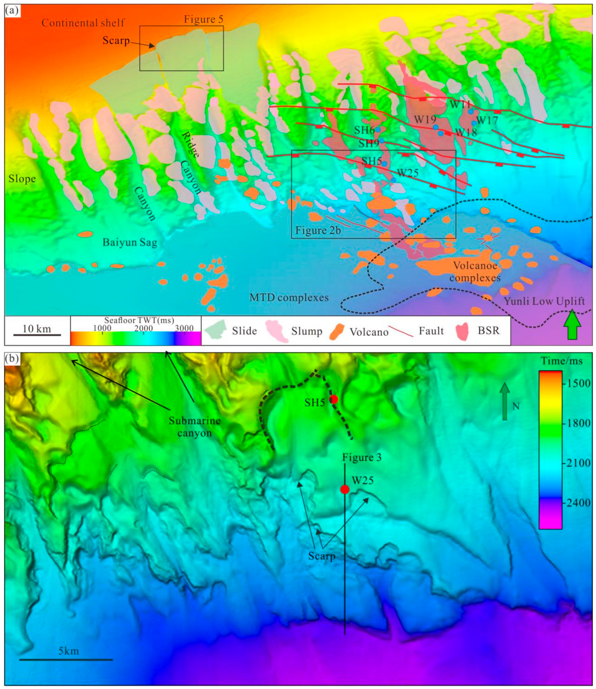
Slides and slumps with different scales, together with faults, volcanoes, and BSRs have been discovered from three dimensional (3D) seismic data and well log data in the Pearl River Mouth Basin (PRMB), South China Sea (SCS) (Figure 2a) [17,18,19,20,21,22,23]. A large number of landslides are located at submarine migrating canyons. Gas hydrate, shallow gas, volcanoes, and normal faults mainly coexist in the migrating canyons. Due to a lack of well log data, there is no clear answer whether large-scale submarine landslides are related to gas hydrate or shallow gas and other factors. However, there is a small submarine slide at the submarine fan of the canyon front where two sites are drilled (Figure 3). The well log data show the occurrence of gas hydrate and shallow gas below the slide. These data can be combined with 3D seismic data to delineate this Quaternary submarine slide. In this study, 3D seismic data and different attributes are used to show the amplitude anomalies related to gas hydrate and shallow gas, then analyze the seafloor slide, gas hydrate, shallow gas, volcanoes, and their distributions to find the underlying interplay between them.

2. Geological Setting and Previous Research

2.1. Regional Geological Background of the Pearl River Mouth Basin

The SCS is situated at the junction of the Eurasian, Pacific, and Indo-Australian plates. Its evolution is notably intricate, marked by processes such as Mesozoic subduction [24,25,26], Cenozoic margin extension, seafloor spreading, ridge jumping, and southward collisions, as well as eastward subduction [27]. The region is also influenced by a significant strike-slip fault in the west margin [28,29]. Furthermore, low-velocity anomalies in the deep mantle beneath SCS have been identified, which are believed to be associated with mantle plume [30]. The International Ocean Discovery Program (IODP) has undertaken several drilling sites, revealing that SCS is characterized as a plate-edge margin distinct from the North Atlantic margin [31]. The findings indicate a rapid transition from extensional rifting to seafloor spreading at Late Cretaceous to Early Eocene [32], emphasizing the critical role of magmatism in the processes of extension and breakup [25]. Additionally, there is substantial evidence for a syn-rift stage [33,34] and post-rift stage [35]. Recent studies have thought the SCS an intermediate one that lies between a magma-poor and magma-rich margin [36,37].
The PRMB is the largest sedimentary basin in SCS which is influenced by tectonic activities and has undergone a significant transformation from an active to a passive continental margin [38]. The Cenozoic rifting period was characterized by multiple phases of rifting, including the Shenhu movement in Paleocene, the first stage of the Zhuqiong movement in Middle Eocene, and the second stage of the Zhuqiong movement in Late Eocene-Oligocene [39]. Throughout this period, the extension direction of the basin shifted from NNW orientation to N–S. The strata developed during this period comprise the Wenchang and Enping Formation, both of which are essential hydrocarbon source rocks for oil and gas. Around 33 Ma, the breakup occurred [40], marking the onset of the Nanhai Stage and leading the PRMB into a post-rift phase. Despite this transition, active faulting [41] and accelerated subsidence [42] still existed in the basin. At ~23 Ma, the Baiyun movement occurred and resulted in the northward migration of the continental shelf. During this time, the depositional environment of the Baiyun sag changed from continental shelf with neritic deposition to deep-water deposition [43]. By ~15 Ma, the spreading of the SCS ceased [43], and the PRMB transitioned into a post-spreading stage. During this stage, fault activity was reactivated in the basin, leading to uplift and erosion in the Dongsha uplift area, which resulted in the development of a series of NWW faults and coinciding with magmatism. The sedimentary sequences formed during the post-rift stage include the Zhuhai Formation, the Zhujiang Formation, the Hanjiang Formation, the Yuehai Formation, the Wanshan Formation, and Quaternary strata. Nineteen nearly parallel submarine canyons in the PRMB began to develop since 13.3 Ma [44,45].

2.2. Geohazards, Gas Hydrates and Shallow Gas in the PRMB

Geohazards refer to the phenomenon or process when the earth undergoes abnormal energy release, material movement, the movement or deformation of geological bodies, and environmental changes under internal, external and man-made geological dynamics. In the PRMB, various types of geohazards of slumps, mass transport deposits, active faults, and fluid-flow-related geological structures, including gas chimneys, gas hydrates, pockmarks, volcanos, creeps, and shallow gas have been well delineated using 3D seismic data and attributes in the PRBM [18,19,21,46].
Complex BSRs, double BSR, and gas hydrates have been well delineated by previous studies using well log, 2D, conventional and broadband reprocessed 3D seismic data, respectively [17,46,47]. In the PRMB, a large number of gas hydrate drillings sites have revealed pore-filling and fracture-filling gas hydrates with different thicknesses ranging from several meters to dozens of meters [17]. The occurrence and accumulation of gas hydrates are related to reservoirs, gas sources, and fluid migrations [17,46,47,48,49,50,51,52]. Multiple types of BSRs and the shifts of BSRs are affected by erosion related to submarine canyons and slides, which show the double BSRs and the coexistence of gas hydrate and free gas in the PRBM [46,47,53,54,55]. Large-scale enhanced reflections indicating fluid migrations have been identified below the BSRs or shallow layers on the seismic profile, which are related to gas chimneys, faults, post-rift magmatism, and slope instability identified from 3D seismic data [18,20,21,22,23,46,47,48]. However, the interplay of vertical migration pathways and their influence on gas hydrate and shallow gas accumulation is not clear, which is important for future gas hydrate and shallow gas exploration and production.

3. Data and Method

3D seismic data acquired in the PRMB with a total area of approximately 22,000 km2 were combined by the China National Offshore Oil Corporation to study gas hydrate distribution. Partial 3D seismic data at four canyons area were reprocessed using broadband processing to describe the detailed reservoir properties and to delineate the thickness and saturations of gas hydrates [46,47]. The sampling interval of 3D seismic data is 4 ms, and the main frequency is about 40–50 Hz. The frequency of reprocessed 3D is broader than those of conventional 3D seismic data. The bin spacings are 25 m × 12.5 m in the in-line and cross-line directions, respectively. The bathymetric map is obtained from the interpretations of seafloor reflections in two-way travel time (TWT, Figure 2).
The BGHSZ is calculated using the measured seafloor temperature, pore water salinity, and the average geothermal gradients of gas hydrate drillings in the PRMB for methane [56]. The average geothermal gradient is about 47 °C/km, and the seafloor temperatures are varied based on the measured seafloor depths. The calculated BGHSZ for 3D seismic data is changed into TWT with the regional P-wave velocity of 1680 m/s [46]. Therefore, the BGHSZ in TWT can be used as one horizon to extract seismic attributes.
Seismic attributes of minimum and maximum amplitude values are conducted along the BGHSZ with different time windows to show the distributions of amplitude anomalies and the internal architecture of different geological features. Acoustic blanking reflection is found below high amplitude reflections, with weak amplitude indicating attenuation caused by free gas. High amplitude reflections above the BSR, showing high resistivity, high P-wave, and S-wave velocities, indicate the occurrence of gas hydrates. The core samples show pore-filling gas hydrate with moderate or high saturations [47,50,57]. For gas hydrates in the submarine slide near site W25, the BSR is found at horizon H1, and the RMS attribute is extracted along this horizon with a time window of 40 ms above it. The 3D graph is plotted to show the fluid migration pathways and the distribution of gas hydrate. The coherence and dip attributes are extracted to demonstrate detailed information about scarp and angles of submarine slides. To better show the spatial variations of gas hydrate, shallow gas, volcanoes, lava flow, and lithology anomalies, the attributes are shown without any smoothing and removing of abnormal data.

4. Results

4.1. Distributions of Amplitude Anomalies Related to Gas Hydrate and Shallow Gas

4.1.1. Seismic Reflection Characteristics of Gas Hydrate and Shallow Gas

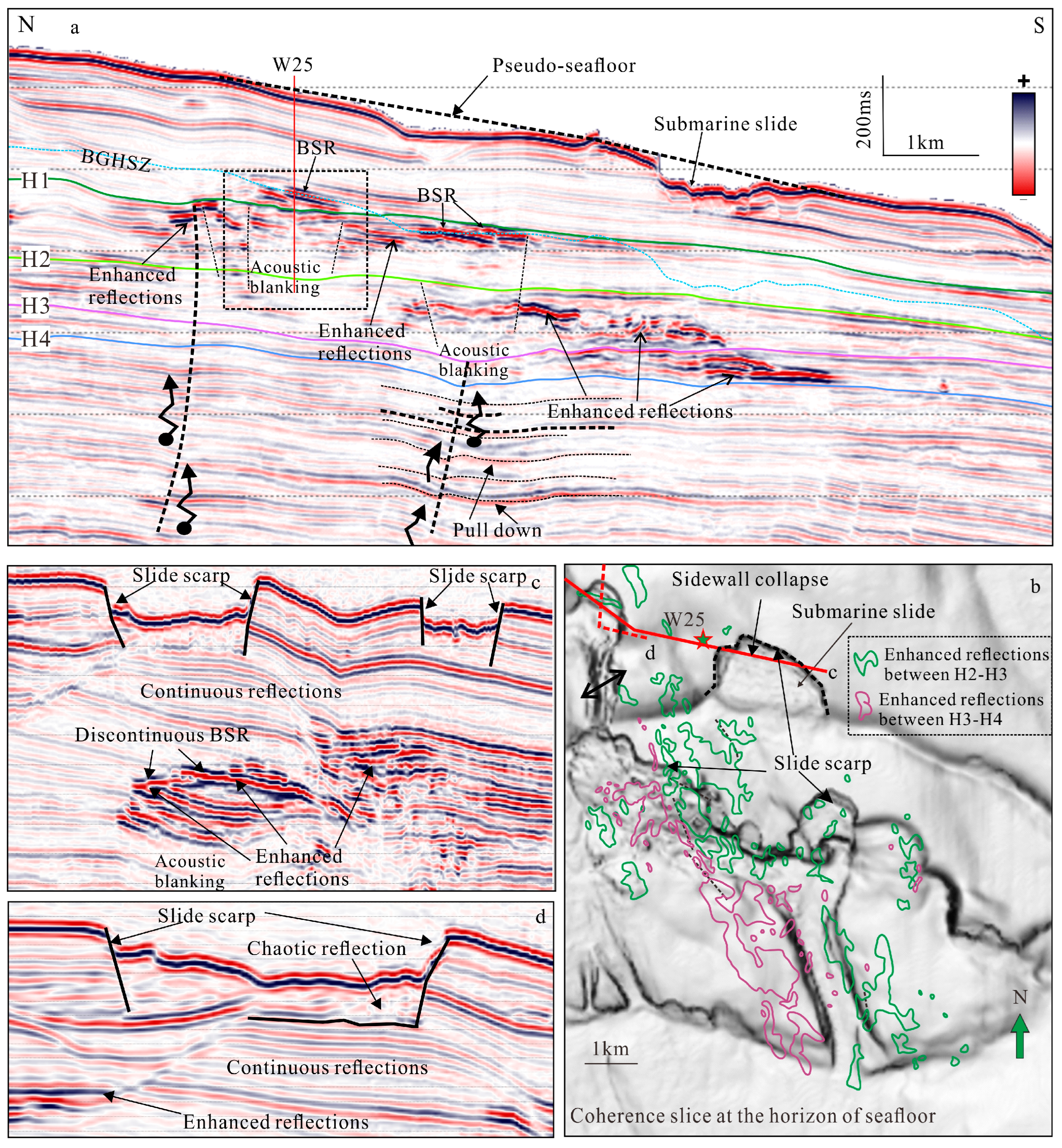
Shallow gas accumulation can be observed from the amplitude anomalies with enhanced reflections or bright spots at the shallow strata (about 300 m), while the amplitude anomalies, such as enhanced reflections, acoustic blanking, acoustic turbidity, and pull-down reflections are often observed in lower sediments due to seismic attenuation (Figure 3). The BSR can be identified in the seismic profile by high amplitude and negative polarity compared to the seafloor showing a ladder-like, discontinuous BSR below the landslide (Figure 3a,c). High-amplitude with positive polarity above the BSR usually indicates the occurrence of gas hydrates with medium to high saturations. The variable depths of the BSR and ladder-like BSR indicate that the BSR has been affected by the landslide [57].
The reservoir properties will be changed when free gas is present, and the shear strength of shallow sediment will be reduced due to the presence of free gas, resulting in seafloor instability and deformation. That is why shallow gas is considered a potential factor to trigger slope failure and is trapped below the base of submarine slides [1,4]. A large amount of enhanced reflections are trapped below gas hydrates, MTDs, or clay-dominated sediments in the deep-water area, which can form a shallow gas field, such as the huge shallow gas field of LS 36-1 [58,59]. In the PRMB, numerous gas hydrate drilling sites have shown the occurrences of free gas below gas hydrate showing low P-wave velocity, high resistivity, and slightly increased S-wave velocity [54,55]. The inverted acoustic impedance profile also shows low values below the BSR indicating the occurrence of free gas [46,47]. The gas source is a mixed source of biogenic (methane gas) or thermogenic gas.

4.1.2. The Spatial Distributions of Gas Hydrates and Shallow Gas

The amplitude attributes extracted from 3D seismic data along the BGHSZ can reveal the distribution of gas hydrates and free gas in the Pearl River Mouth Basin. The gas hydrate distribution is displayed from the maximum amplitude attribute within a 100 ms time window up along the BGHSZ. Gas hydrates show high amplitude reflections above the BSR or the BGHSZ. Gas hydrates in the PRMB are found to occur in the bathyal-abysmal areas in the Baiyun Sag, where water depths exceed 300–400 m based on the calculated BGHSZ. The ridges of four submarine unidirectional migration canyons near the deep-water gas field LW3-1 constitute favorable zones for gas hydrate occurrence, known as the LW3 area (Figure 4a). Within the canyon fan between the LW3 area and the submarine volcano complexes to the south, gas hydrates with strong amplitude reflections are also developed (Figure 4a). A gas hydrate-bearing zone with strong amplitudes is also found near well LW13-1 in the south, located southwest of volcanic complexes within the submarine fan deposition area at the termini of multiple submarine canyons (Figure 4). This area is also characterized by multiple superimposed MTDs interbedded with submarine fan bodies within the outer canyon of the Pearl River Mouth (Figure 3a) [20,60,61].
The minimum amplitude attribute extracted below the BGHSZ within a 50 ms time window reveals the shallow gas distribution, which is generally consistent with that of gas hydrates, but covers a large area (Figure 4b). In the migrating canyons, specifically the LW3 area, shallow gas can be distributed both on the canyon ridge and along the canyon axis. Between the southern LW3 and the volcano complexes, shallow gas exhibits a blocky or patchy distribution (Figure 4b). Shallow gas mainly occurred below the MTDs near LW13-1. It should not be overlooked that there are high amplitude reflection areas in the northwest and west of the submarine canyon group. These are amplitude anomalies caused by sand-rich sediments within and at the end of the canyons, which are not connected to gas hydrates and free gas (Figure 4b).

4.2. Submarine Landslides and Their Relationships with Gas Hydrate Shallow Gas

4.2.1. Characteristics of Submarine Slides

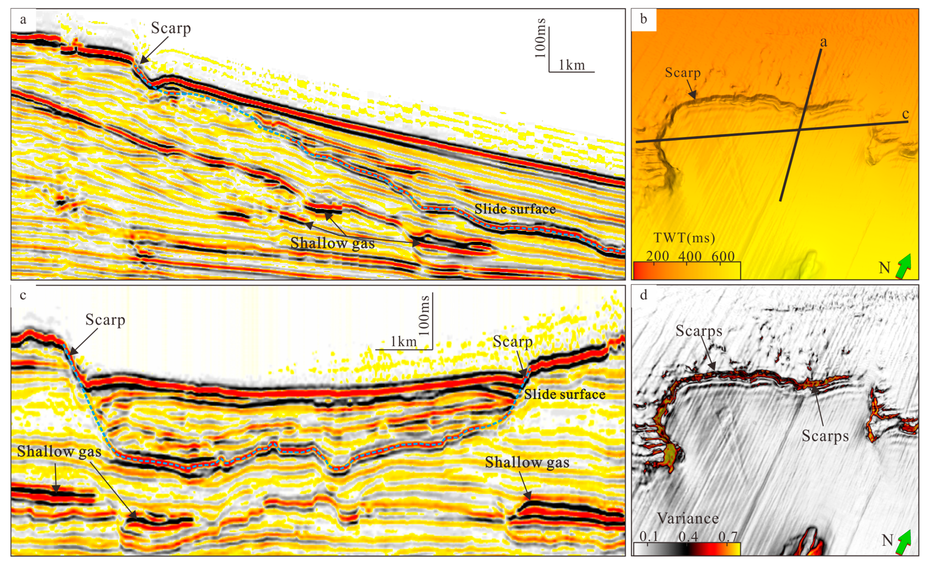
The shelf break zone is the foremost edge of the shallow-water sediments on the shelf, where the topographic dip begins to increase, making it the area most prone to submarine landslides. On the seabed topographic map, small-scale slide (km-scale) can be observed near the shelf break zone of the Baiyun Sag (Figure 2 and Figure 5). On the seismic profile, a distinct strong-amplitude, positive-polarity slide surface is observed, with minimal deformation above the slide surface. In terms of seabed topography, the distance between the eastern and western scarps of the slide is 7.5 km, and the slip surface can be traced for a distance of ~8 km in the north–south direction. The presence of shallow gas is indicated by strong reflections in local strata below the slide surface (Figure 5a,c), suggesting a possible intrinsic connection with the slide occurrence.
Besides the Baiyun Slide, a modern slide near site W25 is identified from the seafloor map and 3D seismic data (Figure 2b). Compared with the surrounding continuous reflections, the seismic reflections are disrupted, which indicates the loss and disturbance of seafloor sediments due to submarine landslides (Figure 3a). The coherence slice along the seafloor shows that the seafloor topography in the study area gradually decreases from north to south, indicating the development of multi-stage submarine landslides. The head of the submarine landslide is semicircular with locally developed erosion gullies, which are consistent with the direction of the submarine landslide (Figure 3b).
At site W25, the BSR shown as opposite polarity to the seafloor is identified near the calculated BGHSZ. Enhanced negative reflections are identified below the BSR that indicates the occurrences of free gas (Figure 3a). The free gas-bearing layers are mainly distributed below the head of submarine landslides and the erosion gullies at the south of site W25, which are shown as discontinuous blocks (Figure 3b). Compared to the normal seafloor area, the downward BSR shifts because of seafloor erosion, and the previous trapped shallow gas will form gas hydrates near the BGHSZ. Thus, at the local submarine landslide area, the terminations of enhanced reflections are shown as a discontinuous BSR, which cut the stratigraphy indicating the gas hydrate occurrences (Figure 3a,c).

4.2.2. Characteristics of Reservoirs and Fluid Migration

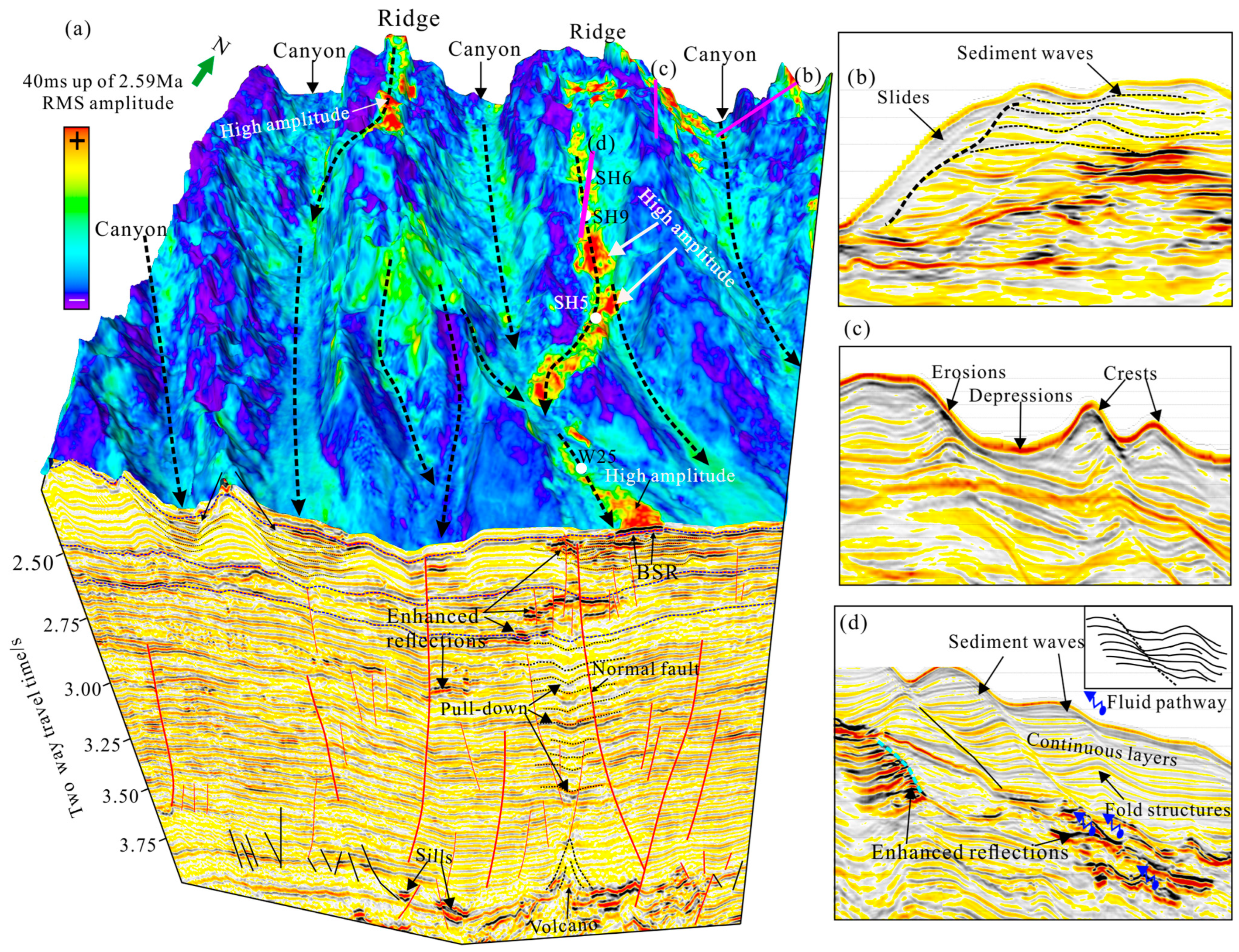
Multiple submarine canyons are developed in the north of the study area, and continuous depressions are identified on the canyon ridges, showing the development of sediment waves (Figure 6a–c). The sediment waves are characterized by vertical successional erosion, and the erosional sidewalls provide an important conduit for the short-distance migration of shallow free gas (Figure 6d). In local areas, the canyon sidewalls show the truncation of sedimentary stratigraphy, indicating the collapse of the canyon sidewalls (Figure 6b). The 3D RMS attribute map along the H1 (2.59 Ma) shows that the enhanced reflections are mainly developed on the canyon ridges and are distributed as a long strip, corresponding to the location of the sediment waves, which indicates the downstream transportation of turbidite sediments in the northern continental shelf. The enhanced reflections are also identified at the local canyon sidewall, indicating sediment transportation from the ridge of the canyon to the bottom (Figure 6a). The study area is located at the end of the canyon, which is the main unloading area for coarse-grained sediments transported through the canyon bottom and sediment waves at the canyon ridge. Thus, the study area is a favorable sand-rich reservoir for gas hydrate accumulation (Figure 6a).
The enhanced reflections, gas hydrates, and free gas are mainly distributed on both sides or the top of the faults, which are the main vertical fluids’ migration pathways. At the bottom of deep faults, dome-shaped volcanic mounds are identified with enhanced positive reflections on both sides, indicating the presence of magmatic intrusions (Figure 6a). Magmatic activities are favorable for the upward migration of deep-sourced thermal fluids along the faults, which provides abundant thermogenic gas for the accumulations of shallow gas and hydrates. Furthermore, the local geothermal gradient will increase due to thermal fluids’ migration, which causes the BGHSZ to shift upward. The previous gas hydrates will dissociate, providing a gas source for the accumulation of gas hydrates and shallow gas.

4.3. Submarine Volcanic Complex

The PRMB is characterized by a large number of sporadically distributed volcanic complexes, with the largest being the Yunli low uplift volcanic complex located south of the LW3 gas hydrate occurrence area. The volcanic complex is exposed on the seafloor, spanning up to 96 km2, and multiple buried volcanoes are visible around the central volcano (Figure 2, Figure 4 and Figure 7) [62]. The volcanic top exhibits a pyramid-shaped reflection with weak amplitude at the apex, whereas the volcanic base displays strong amplitude and positive polarity reflection indicative of lava flows [21,23]. The interior of the volcano presents chaotic reflections, with locally visible continuous and pull-up reflection axes that align vertically with the volcanic apex, representing vertical migration pathways for magma [62,63]. High amplitude, strong and local phase reversal reflections are observed in the shallow strata directly above the buried volcano in the north of the seabed volcano, indicating gas hydrate and free gas occurrences at the shallow strata (Figure 6a). The strata between the volcanic apex and the shallow gas show pull-down and weak reflections, forming a chimney-like structure. The disruption of internal reflection suggests fault occurrence, which originates at the volcanic top and is formed due to differential compaction of sediments (Figure 6a) [21]. These observations indicate that the development of buried volcanoes can trigger fault activity and provide pathways for fluid migration, which will facilitate the occurrence of free gas and gas hydrates in shallow strata.

5. Discussion

5.1. Types and Distribution of Submarine Geohazards

Seafloor submarine geohazards in the PRMB can be divided into two types. Type I includes slide, slump, and mass transport deposits related to the development of submarine slides, and type II includes hydrates, free gas, fluid migration systems, and submarine volcanoes related to fluid migration and occurrence.
Type I is widely developed in near-seafloor sediments on global continental margins. The submarine slide system develops a complete sedimentary process from the head, including slide, slump, turbidity currents, and MTDs [64]. Continental slope instability occurs when the sediment gravity exceeds the mechanical strength of sedimentary strata. However, the occurrence of submarine slides requires certain triggering mechanisms to break the balance between sediment gravity and mechanical strength. Therefore, the continental slope may be controlled by a variety of geological and environmental factors, such as earthquakes [65], volcanic activities [66], gas hydrate dissolution [67,68], and release of shallow overpressured fluid [12,69]. In the PRMB, a small-scale slide occurs near the shelf break zone, with a water depth range of 300–400 m (Figure 5). The terrain in this area changes rapidly from the shelf to the continental slope, and it is also the location that receives terrigenous sediments the fastest and in the largest amount, so it is the area where submarine landslides are most likely to start [68]. Submarine canyons are widely developed in the continental slope area. Due to the large terrain angle of the canyon flanks, which can reach 25°, slumping accumulates laterally from the canyon ridge to the canyon axis, with a water depth ranging from 500 to 1500 m, and may show multi-stage sliding characteristics (Figure 6). Moreover, the steep terrain may be the main driving factor for the slump near the canyon flank. The formation of slumping will also promote the development of the vertical migration characteristics of the canyon and erode the canyon flanks together with turbidity currents and bottom currents, forming a unidirectional migration feature [44]. After the sediments from the shelf and the continental slope are transported, sediment unloading occurs in the lower continental slope area. The terminus of the submarine canyon is the outer canyon of the Pearl River Mouth, and a large number of multi-stage superimposed MTDs are developed inside it, with a total area of approximately 70 km2. The formation ages of the three-stage MTDs determined by using ODP 1146 and 2D seismic data are 1.59 Ma, 0.79 Ma, and 0.54 Ma [20]. Therefore, as sediment deformation increases, sliding develops from the shelf break to the lower continental slope, slumping occurs in the continental slope area, and MTDs are developed in the lower continental slope.
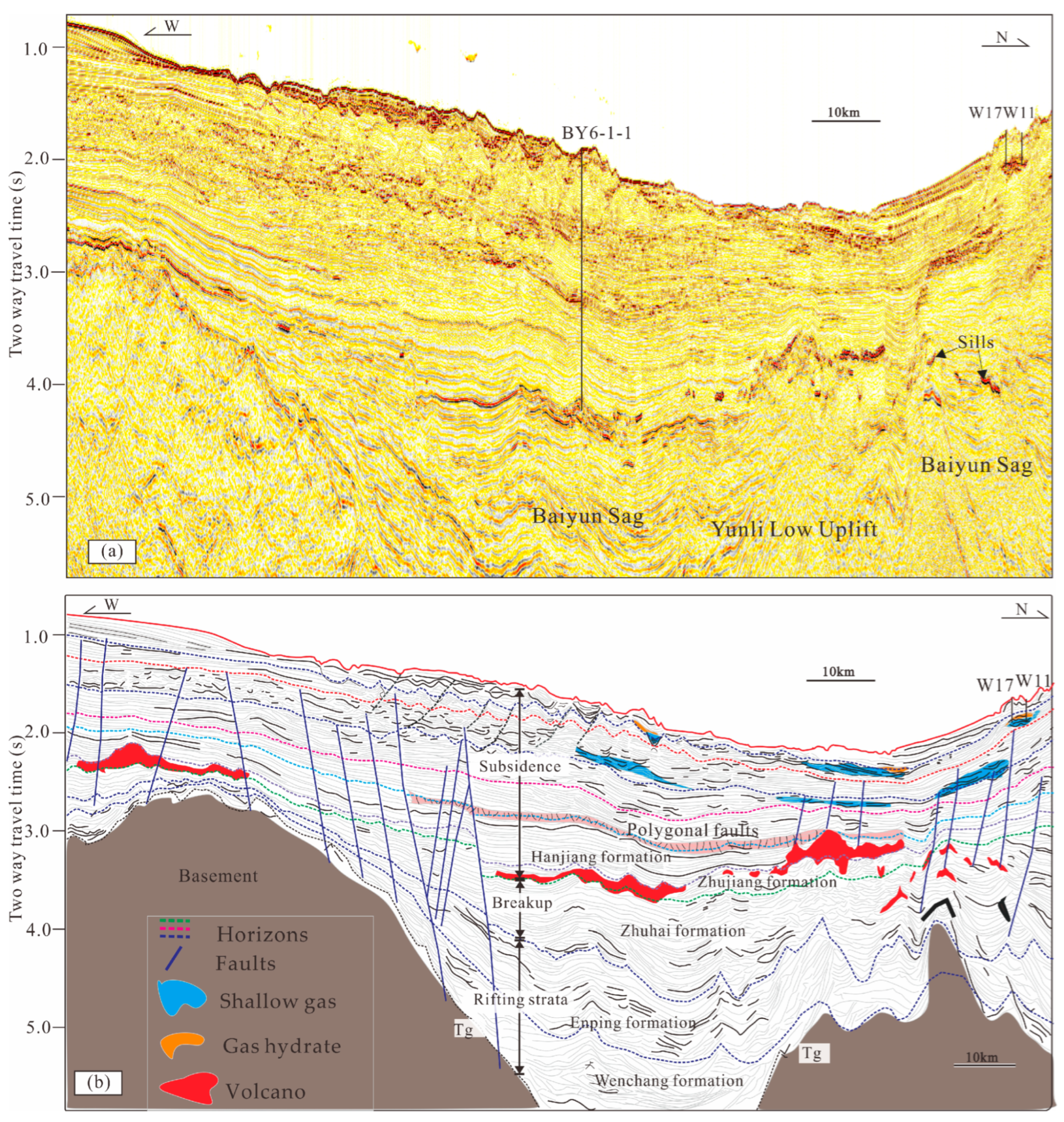
Type II is related to fluid migration and accumulation in the basin and is associated with fluid migration systems and favorable coarse-grained sedimentary reservoir conditions [52]. The BSR is an important indicator for identifying shallow gas and gas hydrates. The 3D seismic data in the PRMB reveals that gas hydrates mainly occur on the ridges of submarine canyons, north of the submarine volcanic complex, and in the canyon fans of the lower continental slope (Figure 4). The distribution of shallow gas is broader, and it can be found both on the ridges and axes of the canyons (Figure 4) [46,62]. Studies such as core geochemical index analysis and hydrocarbon generation simulation show that deep thermogenic gas and biogenic gas source make important contributions to hydrocarbon accumulation in shallow strata [23,50]. Gas chimneys and normal fault structures are superimposed, which can provide the lateral and vertical pathways for fluid migration on the occurrence areas of shallow gas and gas hydrates. As fluid migration structures, they vertically transport deep fluids to shallow strata, thus playing an important role in the occurrence of shallow gas and hydrates. Meanwhile, submarine volcanoes are developed in the south of the gas hydrate occurrence area. The development of volcanic complexes is conducive to the development of fluid migration systems, such as submarine faults and chimneys, and shallow gas and gas hydrates are developed in the corresponding strata on the tops of the volcanoes [21,62].

5.2. Submarine Geohazards Related to the Distribution of Gas Hydrates

The Baiyun Sag in the PRMB is a deep-water sedimentary sag with active hydrocarbon fluids. The intensive hydrocarbon drilling data indicate that the resources such as deep-water oil and gas, gas hydrates and shallow gas have huge potential and are widely developed [43,50]. Therefore, our research focuses on the controlling effect of deep-water geohazards on the distribution and accumulations of gas hydrates and free gas.
Submarine slides develop near the shelf break zone. A large amount of fluid converges near the shelf break through lateral and vertical interactive migration. In the seismic profiles, it is found that free gas occurs beneath the slide surface, indicating that the initiation of slide may be related to shallow gas occurrence (Figure 5 and Figure 7), which has been widely discovered in world oceans. For example, in the Danube channel–levee system in the Black Sea, the increase in seawater salinity causes the dissolution of gas hydrates, which then leads to the occurrence of submarine slides near the shelf break zone [68]. The release of overpressured fluid in the shallow strata to the shallow permeable strata can lead to the development of weak strata surfaces. Under the action of gravity, the shallow sediments become unstable along the weak surfaces, that is, the slip surfaces, such as in the Arctic Ocean [12].
The slump on the flanks of the canyons in the Baiyun Sag may cause the thinning of the sedimentary strata above the gas hydrates-bearing sediments. As a result, the temperature and pressure of the sediments change, usually causing the downward adjustment of the gas hydrate stability zone. The free gas below the original gas hydrates enters the BGHSZ and reforms the gas hydrate (Figure 6 and Figure 7) [17,47,57]. In addition, under the migration effect of fault and chimney structures, the occurrence of shallow fluid on the canyon ridges can also cause local overpressure in the strata, which helps to make the sedimentary strata on the canyon ridges unstable and leads to slump [19].
The MTDs are mainly composed of fine-grained sediments and are transported to the deep-water area, which will cause the dewatering of sediments. Therefore, the MTD layers have lower porosity, lower water content, and higher density than those of the surrounding sediments. Their influence on shallow gas and gas hydrates is mainly the sealing effect (Figure 7). Similar findings have been made in the Qiongdongnan Basin in the South China Sea [70], the Ullung Basin [71], the Gulf of Mexico [72], and the Nankai Trough in Japan [73]. MTD is also a kind of rapid sedimentation, which causes rapid changes and adjustments in the temperature and pressure conditions of submarine sediments and the upward adjustment of the BGHSZ. In this case, gas hydrates may dissolve, and the free gas migrates vertically into the new BGHSZ to form gas hydrates. For example, the two layers of rapid MTD on the Hikurangi Margin in New Zealand cause the upward adjustment of the BGHSZ, and the double BSR is developed in the seismic data [14,47]. The rapidly deposited MTD in the Krishna–Godavari Basin, India causes the upward adjustment of the BGHSZ, and the coexistence of gas hydrates and free gas appears in the sandy reservoir [60]. This phenomenon has not yet been found in the outer canyon of the Pearl River Mouth, but it is an issue that needs attention in future research.
Therefore, the development of submarine slides has an obvious controlling effect on the distribution of gas hydrates and shallow gas, and there is an interactive relationship between them. The slides and slumps are widely distributed in the migrating submarine canyon area, which will cause the changes in erosion and sedimentation at different locations. They will influence the depths of the BGHSZ and different types of BSRs. At the ridges of canyons, most BSR shifts upward, showing the influence of sedimentation; that is, the development of submarine landslides may limit the spatial distribution of gas hydrate and shallow gas. Conversely, the development and adjustment of gas hydrates and shallow gas may trigger the occurrence of submarine slides.

6. Conclusions

Three-dimensional seismic data were used to investigate the types and distribution of shallow geohazards in the Pearl River Mouth Basin, including geohazards related to submarine slides, such as slide, slump, and mass transport deposits (MTDs), as well as gas hydrates, shallow gas, fluid migration pathways, and submarine volcanic complexes associated with fluid migration and occurrence. As the water depth increases from shallow to deep, slide, slump, and MTDs occur, distributed, respectively, in the shelf break zone, slope submarine canyons, and the lower slope terminus of submarine canyons. Their formation may be related to the occurrence of shallow gas hydrates and free gas, which in turn can lead to dynamic adjustments in the gas hydrate and shallow gas systems. Fluid migration pathways and submarine volcanoes transport deep gas sources to shallow strata, providing the gas sources for the occurrences of gas hydrates and shallow gas. The formations of various types of submarine hazards are interconnected, influencing and constraining each other, thereby providing a reference for further understanding the geological element model of shallow strata.

Author Contributions

All authors contributed equally. All authors have read and agreed to the published version of the manuscript.

Funding

The research works are financially supported by the State Key Laboratory of Natural Gas Hydrate (2022-KFJJ-SHW), the National Natural Science Foundation of China (42206063), the Hainan Province Key Research and Development Project (ZDYF2024GXJS002), and Research Start-up Funds of Zhufeng Scholars Program.

Institutional Review Board Statement

Not applicable.

Informed Consent Statement

Not applicable.

Data Availability Statement

The data presented in this study are available on request from the corresponding author due to (specify the reason for the restriction).

Conflicts of Interest

Authors Li Lixia and Zhu Zhenyu were employed by the company CNOOC Research Institute Co., Ltd., Beijing. Author Li Jie was employed by the company CNOOC China Limited Shenzhen Branch, Shenzhen. The remaining authors declare that the research was conducted in the absence of any commercial or financial relationships that could be construed as a potential conflict of interest.

References

  1. Sultan, N.; Foucher, J.; Cochonat, P.; Tonnerre, T.; Bourillet, J.; Ondreas, H.; Cauquil, E.; Grauls, D. Dynamics of gas hydrate: Case of the Congo continental slope. Mar. Geol. 2004, 206, 1–18. [Google Scholar] [CrossRef]
  2. Bünz, S.; Mienert, J.; Vanneste, M.; Andreassen, K. Gas hydrates at the Storegga Slide: Constraints from an analysis of multicomponent, wide-angle seismic data. Geophysics 2005, 70, B19–B34. [Google Scholar] [CrossRef]
  3. Mienert, J.; Vanneste, M.; Bünz, S.; Andreassen, K.; Haflidason, H.; Sejrup, H.P. Ocean warming and gas hydrate stability on the mid-Norwegian margin at the Storegga Slide. Mar. Pet. Geol. 2005, 22, 233–244. [Google Scholar] [CrossRef]
  4. Farahani, M.V.; Hassanpouryouzband, A.; Yang, J.; Tohidi, B. Insights into the climate-driven evolution of gas hydrate-bearing permafrost sediments: Implications for prediction of environmental impacts and security of energy in cold regions. RSC Adv. 2021, 11, 14334–14346. [Google Scholar] [CrossRef] [PubMed]
  5. Daigle, H.; Cook, A.; Fang, Y.; Bihani, A.; Song, W.; Flemings, P.B. Gas-driven tensile fracturing in shallow marine sediments. J. Geophys. Res. Solid Earth 2020, 125, e2020JB020835. [Google Scholar] [CrossRef]
  6. Karstens, J.; Haflidason, H.; Berndt, C.; Crutchley, G.J. Revised Storegga Slide reconstruction reveals two major submarine landslides 12,000 years apart. Commun. Earth Environ. 2023, 4, 55. [Google Scholar] [CrossRef]
  7. Ruppel, C.D.; Kessler, J.D. The interaction of climate change and methane hydrates. Rev. Geophys. 2017, 55, 126–168. [Google Scholar] [CrossRef]
  8. Brothers, L.L.; Van Dover, C.L.; German, C.R.; Kaiser, C.L.; Yoerger, D.R.; Ruppel, C.D.; Lobecker, E.; Skarke, A.D.; Wagner, J.K.S. Evidence for extensive methane venting on the southeastern US Atlantic margin. Geology 2013, 41, 807–810. [Google Scholar] [CrossRef]
  9. Davies, R.J.; Yang, J.; Li, A.; Mathias, S.; Hobbs, R. An irregular feather-edge and potential outcrop of marine gas hydrate along the Mauritanian margin. Earth Planet. Sci. Lett. 2015, 423, 202–209. [Google Scholar] [CrossRef]
  10. Skarke, A.; Ruppel, C.; Kodis, M.; Brothers, D.; Lobecker, E. Widespread methane leakage from the sea floor on the northern US Atlantic margin. Nat. Geosci. 2014, 7, 657–661. [Google Scholar] [CrossRef]
  11. Berndt, C.; Feseker, T.; Treude, T.; Krastel, S.; Liebetrau, V.; Niemann, H.; Bertics, V.J.; Dumke, I.; Dünnbier, K.; Ferré, B.; et al. Temporal constraints on hydrate-controlled methane seepage off Svalbard. Science 2014, 343, 284–287. [Google Scholar] [CrossRef] [PubMed]
  12. Elger, J.; Berndt, C.; Rüpke, L.; Krastel, S.; Gross, F.; Geissler, W.H. Submarine slope failures due to pipe structure formation. Nat. Commun. 2018, 9, 715. [Google Scholar] [CrossRef]
  13. Davies, R.J.; Thatcher, K.E.; Mathias, S.A.; Yang, J. Deepwater canyons: An escape route for methane sealed by methane hydrate. Earth Planet. Sci. Lett. 2012, 323–324, 72–78. [Google Scholar] [CrossRef]
  14. Han, S.; Bangs, N.L.; Hornbach, M.J.; Pecher, I.A.; Tobin, H.J.; Silver, E.A. The many double BSRs across the northern Hikurangi margin and their implications for subduction processes. Earth Planet. Sci. Lett. 2021, 558, 116743. [Google Scholar] [CrossRef]
  15. Dugan, B.; Flemings, P.B. Overpressure and fluid flow in the New Jersey continental slope: Implications for slope failure and cold seeps. Science 2000, 289, 288–291. [Google Scholar] [CrossRef] [PubMed]
  16. Dugan, B.; Flemings, P.B.; Olgaard, D.L.; Gooch, M. Consolidation, effective stress, and fluid pressure of sediments from ODP Site 1073, US mid-Atlantic continental slope. Earth Planet. Sci. Lett. 2003, 215, 13–26. [Google Scholar] [CrossRef]
  17. Wang, X.; Collett, T.S.; Lee, M.W.; Yang, S.; Guo, Y.; Wu, S. Geological controls on the occurrence of gas hydrate from core, downhole log, and seismic data in the Shenhu area, South China Sea. Mar. Geol. 2014, 357, 272–292. [Google Scholar] [CrossRef]
  18. Zhao, F.; Alves, T.M.; Li, W.; Wu, S. Recurrent slope failure enhancing source rock burial depth and seal unit competence in the Pearl River Mouth Basin, offshore South China Sea. Tectonophysics 2015, 643, 1–7. [Google Scholar] [CrossRef]
  19. Chen, D.; Wang, X.; Völker, D.; Wu, S.; Wang, L.; Li, W.; Li, Q.; Zhu, Z.; Li, C.; Qin, Z.; et al. Three dimensional seismic studies of deep-water hazard-related features on the northern slope of South China Sea. Mar. Pet. Geol. 2016, 77, 1125–1139. [Google Scholar] [CrossRef]
  20. Sun, Q.; Alves, T.; Xie, X.; He, J.; Li, W.; Ni, X. Free gas accumulations in basal shear zones of mass-transport deposits (Pearl River Mouth Basin, South China Sea): An important geohazard on continental slope basins. Mar. Pet. Geol. 2017, 81, 17–32. [Google Scholar] [CrossRef]
  21. Sun, Q.; Alves, T.M.; Lu, X.; Chen, C.; Xie, X. True volumes of slope failure estimated from a quaternary mass-transport deposit in the northern South China Sea. Geophys. Res. Lett. 2018, 45, 2642–2651. [Google Scholar] [CrossRef]
  22. Sun, Q.; Cartwright, J.; Xie, X.; Lu, X.; Yuan, S.; Chen, C. Reconstruction of repeated Quaternary slope failures in the northern South China Sea. Mar. Geol. 2018, 401, 17–35. [Google Scholar] [CrossRef]
  23. Sun, Q.; Jackson, C.A.L.; Magee, C.; Xie, X. Deeply buried ancient volcanoes control hydrocarbon migration in the South China Sea. Basin Res. 2020, 32, 146–162. [Google Scholar] [CrossRef]
  24. Hall, R. Late Jurassic–Cenozoic reconstructions of the Indonesian region and the Indian Ocean. Tectonophysics 2012, 570–571, 1–41. [Google Scholar] [CrossRef]
  25. Sun, Z.; Lin, J.; Qiu, N.; Jian, Z.; Wang, P.; Pang, X.; Zheng, J.; Zhu, B. The role of magmatism in the thinning and breakup of the South China Sea continental margin: Special Topic: The South China Sea Ocean Drilling. Natl. Sci. Rev. 2019, 6, 871–876. [Google Scholar] [CrossRef] [PubMed]
  26. Taylor, B.; Hayes, D.E. Origin and History of the South China Sea Basin. Geophys. Union Geophys. Monogr. 1983, 27, 23–56. [Google Scholar]
  27. Lester, R.; McIntosh, K.; Van Avendonk, H.J.; Lavier, L.; Liu, C.-S.; Wang, T. Crustal accretion in the Manila trench accretionary wedge at the transition from subduction to mountain-building in Taiwan. Earth Planet. Sci. Lett. 2013, 375, 430–440. [Google Scholar] [CrossRef]
  28. Replumaz, A.; Lacassin, R.; Tapponnier, P.; Leloup, P.H. Large river offsets and Plio-Quaternary dextral slip rate on the Red River fault (Yunnan, China). J. Geophys. Res. 2001, 106, 819–836. [Google Scholar] [CrossRef]
  29. Sun, Z.; Zhou, D.; Zhong, Z.; Zeng, Z.; Wu, S. Experimental evidence for the dynamics of the formation of the Yinggehai basin, NW South China Sea. Tectonophysics 2003, 372, 41–58. [Google Scholar] [CrossRef]
  30. Hua, Y.; Zhao, D.; Xu, Y. Azimuthal Anisotropy Tomography of the Southeast Asia Subduction System. J. Geophys. Res. Solid Earth 2022, 127, e2021JB022854. [Google Scholar] [CrossRef]
  31. Wang, P. New insights into marine basin opening. Natl. Sci. Rev. 2019, 6, 870. [Google Scholar] [CrossRef] [PubMed]
  32. Larsen, H.C.; Mohn, G.; Nirrengarten, M.; Sun, Z.; Stock, J.; Jian, Z.; Klaus, A.; Alvarez-Zarikian, C.A.; Boaga, J.; Bowden, S.A.; et al. Rapid transition from continental breakup to igneous oceanic crust in the South China Sea. Nat. Geosci. 2018, 11, 782–789. [Google Scholar] [CrossRef]
  33. Hao, S.; Mei, L.; Pang, X.; Gernigon, L.; Paton, D.; Zheng, J.; Ye, Q.; Zhou, Z.; Zhong, Y. Rifted margin with localized detachment and polyphase magmatism: A new model of the northern South China Sea. GSA Bull. 2022, 135, 1667–1687. [Google Scholar] [CrossRef]
  34. Zhang, C.; Sun, Z.; Manatschal, G.; Pang, X.; Qiu, N.; Su, M.; Zheng, J.; Li, H.; Gu, Y.; Zhang, J.; et al. Syn-rift magmatic characteristics and evolution at a sediment-rich margin: Insights from high-resolution seismic data from the South China Sea. Gondwana Res. 2021, 91, 81–96. [Google Scholar] [CrossRef]
  35. Ding, W.; Li, J. Propagated rifting in the Southwest Sub-basin, South China Sea: Insights from analogue modeling. J. Geodyn. 2016, 100, 71–86. [Google Scholar] [CrossRef]
  36. Ding, W.; Sun, Z.; Mohn, G.; Nirrengarten, M.; Tugend, J.; Manatschal, G.; Li, J. Lateral evolution of the rift-to-drift transition in the South China Sea: Evidence from multi-channel seismic data and IODP Expeditions 367&368 drilling results. Earth Planet. Sci. Lett. 2020, 531, 115932. [Google Scholar] [CrossRef]
  37. Pérez-Gussinyé, M.; Collier, J.S.; Armitage, J.J.; Hopper, J.R.; Sun, Z.; Ranero, C.R. Towards a process-based understanding of rifted continental margins. Nat. Rev. Earth Environ. 2023, 4, 166–184. [Google Scholar] [CrossRef]
  38. He, M.; Zhong, G.; Liu, X.; Liu, L.; Shen, X.; Wu, Z.; Huang, K. Rapid post-rift tectonic subsidence events in the Pearl River Mouth Basin, northern South China Sea margin. J. Asian Earth Sci. 2017, 147, 271–283. [Google Scholar] [CrossRef]
  39. Gao, J.; Peng, X.; Wu, S.; Lüdmann, T.; McIntosh, K.; Ma, B.; Xu, Z. Different expressions of the crustal structure across the Dongsha Rise along the northeastern margin of the South China Sea. J. Asian Earth Sci. 2019, 171, 187–200. [Google Scholar] [CrossRef]
  40. Li, C.; Xu, X.; Lin, J.; Sun, Z.; Zhu, J.; Yao, Y.; Zhao, X.; Liu, Q.; Kulhanek, D.K.; Wang, J.; et al. Ages and magnetic structures of the South China Sea constrained by deep tow magnetic surveys and IODP Expedition 349. Geochem. Geophys. Geosyst. 2014, 15, 4958–4983. [Google Scholar] [CrossRef]
  41. Sun, Z.; Xu, Z.; Sun, L.; Pang, X.; Yan, C.; Li, Y.; Zhao, Z.; Wang, Z.; Zhang, C. The mechanism of post-rift fault activities in Baiyun sag, Pearl River Mouth basin. J. Asian Earth Sci. 2014, 89, 76–87. [Google Scholar] [CrossRef]
  42. Dong, D.; Wu, S.; Zhang, G.; Yuan, S. Rifting process and formation mechanisms of syn-rift stage prolongation in the deepwater basin, northern South China Sea. Chin. Sci. Bull. 2008, 53, 3715–3725. [Google Scholar] [CrossRef]
  43. Pang, X.; Chen, C.; Shao, L.; Wang, C.; Zhu, M.; He, M.; Shen, J.; Lian, S.; Wu, X. Baiyun Movement, a Great Tectonic Event on the Oligocene-Miocene Boundary in the Northern South China Sea and Its Implications. Geol. Rev. 2007, 53, 145–151, (In Chinese with English Abstract). [Google Scholar]
  44. Zhu, M.; Graham, S.; Pang, X.; McHargue, T. Characteristics of migrating submarine canyons from the middle Miocene to present: Implications for paleoceanographic circulation, northern South China Sea. Mar. Pet. Geol. 2020, 27, 307–319. [Google Scholar] [CrossRef]
  45. Lin, Z.; Su, M.; Zhuo, H.; Chen, H.; Jin, J.; Huang, S.; Wang, Z. Depositional architecture and evolution of Quaternary submarine canyon-fan system in the Baiyun Sag of the Pearl River Mouth Basin, northern South China Sea. Mar. Pet. Geol. 2024, 170, 107167. [Google Scholar] [CrossRef]
  46. Wang, X.; Qian, J.; Collett, T.S.; Shi, H.; Yang, S.; Yan, C.; Li, Y.; Wang, Z.; Chen, D. Characterization of gas hydrate distribution using conventional 3D seismic data in the Pearl River Mouth Basin, South China Sea. Interpretation 2016, 4, SA25–SA37. [Google Scholar] [CrossRef]
  47. Wang, X.; Han, L.; Liu, J.; Jin, J.; Kuang, Z.; Zhou, J. The geophysical characteristics and identification of the coexistence of gas hydrate and free gas. Earth Sci. Front. 2025, 32, 1–16, (In Chinese with English Abstract). [Google Scholar]
  48. Jin, J.; Wang, X.; Guo, Y.; Li, J.; Li, Y.; Zhang, X.; Qian, J.; Sun, L. Geological controls on the occurrence of recently formed highly concentrated gas hydrate accumulations in the Shenhu area, South China Sea. Mar. Pet. Geol. 2020, 116, 104294. [Google Scholar] [CrossRef]
  49. Wu, S.-G.; Sun, Q.L.; Wu, T.-Y.; Yuan, S.Q.; Ma, Y.B.; Yao, G.S. Polygonal fault and oil-gas accumulation in deepwater area of Qiongdongnan Basin. Acta Pet. Scinca 2009, 30, 22–27. [Google Scholar]
  50. Yang, S.-X.; Zhang, M.; Liang, J.-Q.; Lu, J.; Zhang, Z.; Holland, M.; Schultheiss, P.; Fu, S.; Sha, Z.; the GMGS3 Science Team. Preliminary results of China’s third gas hydrate drilling expedition: A critical step from discovery to development in the South China Sea. Fire Ice Newsl. 2015, 15, 1–5. [Google Scholar]
  51. Cheng, C.; Jiang, T.; Kuang, Z.; Yang, C.; Zhang, C.; He, Y.; Cheng, Z.; Tian, D.; Xiong, P. Characteristics of gas chimneys and their implications on gas hydrate accumulation in the Shenhu area, northern south China sea. J. Nat. Gas Sci. Eng. 2020, 84, 103629. [Google Scholar] [CrossRef]
  52. Collett, T.-S.; Johnson, A.; Knapp, C.; Boswell, R. (Eds.) Natural gas hydrates: A review. In Natural Gas Hydrates–Energy Resource Potential and Associated Geologic Hazards; AAPG Memoir: Washington, DC, USA, 2009; Volume 89, pp. 146–219. [Google Scholar]
  53. Qian, J.; Wang, X.; Collett, T.S.; Guo, Y.; Kang, D.; Jin, J. Downhole log evidence for the coexistence of structure II gas hydrate and free gas below the bottom simulating reflector in the South China Sea. Mar. Pet. Geol. 2018, 98, 662–674. [Google Scholar] [CrossRef]
  54. Kang, D.; Lu, J.; Zhang, Z.; Liang, J.; Kuang, Z.; Lu, C.; Kou, B.; Lu, Q.; Wang, J. Fine-grained gas hydrate reservoir properties estimated from well logs and lab measurements at the Shenhu gas hydrate production test site, the northern slope of the South China sea. Mar. Pet. Geol. 2020, 122, 104676. [Google Scholar] [CrossRef]
  55. Zhan, L.; Kang, D.; Lu, H.; Lu, J. Characterization of coexistence of gas hydrate and free gas using sonic logging data in the Shenhu Area, South China Sea. J. Nat. Gas Sci. Eng. 2022, 101, 104540. [Google Scholar] [CrossRef]
  56. Sloan, E.D., Jr.; Koh, C.A. Clathrate Hydrates of Natural Gases; CRC Press: Boca Raton, FL, USA, 2007. [Google Scholar]
  57. Zhou, J.; Wang, X.; Zhu, Z.; Jin, J.; Song, H.; Su, B.; Qian, J.; Zhang, G. The influence of submarine landslides on the distribution and enrichment of gas hydrate and free gas. Chin. J. Geophys. 2022, 65, 3674–3689, (In Chinese with English Abstract). [Google Scholar]
  58. Pei, J.; Liu, E.; Song, P.; Yan, D.; Luo, W.; Zhan, J.; Wang, Z.; Li, G.; Uysal, I.T.; Yang, P. Influencing Factors and Model of Shallow Gas Enrichment in the Quaternary Sediments of the Qiongdongnan Basin, South China Sea. J. Mar. Sci. Eng. 2024, 12, 1928. [Google Scholar] [CrossRef]
  59. Xu, C.-G.; Wu, K.-Q.; Pei, J.-X.; Hu, L. Enrichment mechanisms and accumulation model of ultra-deep water and ultra-shallow gas: A case study of Lingshui 36-1 gas field in Qiongdongnan Basin, South China Sea. Pet. Explor. Dev. 2024, 51, 1–13, (In Chinese with English Abstract). [Google Scholar]
  60. Zhou, J.; Wang, X.; Collett, T.S.; Li, S.; Kuang, Z.; Lu, Y.; Deng, W.; Yan, W.; Qian, J.; Jin, J. Characterization of a complex sand-rich gas hydrate reservoir system in the Indian marine continental margin with downhole log and seismic data. Mar. Pet. Geol. 2023, 155, 106370. [Google Scholar] [CrossRef]
  61. Yan, C.; Shi, H.; Li, Y.; Li, J.; Zhu, Y.; Wang, X. Identification and accumulation control factors of natural gas hydrate and shallow gas in Baiyun Sag, Pearl River Mouth Basin. China Offshore Oil Gas 2018, 8, 25–32. [Google Scholar]
  62. Jin, J.; Wang, X.; Zhang, Z.; He, M.; Magee, C.; Li, J.; Li, Y.; Li, S.; Luan, Z.; Zhang, G.; et al. Shallow gas and gas hydrate accumulations influenced by magmatic complexes in the Pearl River Mouth Basin, South China Sea. Mar. Geol. 2022, 453, 106928. [Google Scholar] [CrossRef]
  63. Sun, Q.; Alves, T.M.; Wu, S.; Zhao, M.; Xie, X. Early Miocene magmatism in the Baiyun Sag (South China Sea): A view to the origin of intense post-rift magmatism. Gondwana Res. 2023, 120, 127–144. [Google Scholar] [CrossRef]
  64. Bull, S.; Cartwright, J.; Huuse, M. A subsurface evacuation model for submarine slope failure. Basin Res. 2009, 21, 433–443. [Google Scholar] [CrossRef]
  65. Pope, E.L.; Talling, P.J.; Carter, L. Which earthquakes trigger damaging submarine mass movements: Insights from a global record of submarine cable breaks? Mar. Geol. 2017, 384, 131–146. [Google Scholar] [CrossRef]
  66. Guan, Z.; Chen, K.; He, M.; Zhu, J.; Zhou, F.; Yu, S. Recurrent mass transport deposits and their triggering mechanisms in the kaiping sag, Pearl River Mouth Basin. Mar. Pet. Geol. 2016, 73, 419–432. [Google Scholar] [CrossRef]
  67. Phrampus, B.J.; Hornbach, M.J. Recent changes to the Gulf Stream causing widespread gas hydrate destabilization. Nature 2012, 490, 527–530. [Google Scholar] [CrossRef]
  68. Riboulot, V.; Ker, S.; Sultan, N.; Thomas, Y.; Marsset, B.; Scalabrin, C.; Ruffine, L.; Boulart, C.; Ion, G. Freshwater lake to salt-water sea causing widespread hydrate dissociation in the Black Sea. Nat. Commun. 2018, 9, 117. [Google Scholar] [CrossRef] [PubMed]
  69. Li, A.; Davies, R.J.; Yang, J. Gas trapped below hydrate as a primer for submarine slope failures. Mar. Geol. 2016, 380, 264–271. [Google Scholar] [CrossRef]
  70. Ye, J.; Wei, J.; Liang, J.; Lu, J.; Lu, H.; Zhang, W. Complex gas hydrate system in a gas chimney, South China Sea. Mar. Pet. Geol. 2019, 104, 29–39. [Google Scholar] [CrossRef]
  71. Horozal, S.; Bahk, J.-J.; Urgeles, R.; Kim, G.Y.; Cukur, D.; Kim, S.-P.; Lee, G.H.; Lee, S.H.; Ryu, B.-J.; Kim, J.-H. Mapping gas hydrate and fluid flow indicators and modeling gas hydrate stability zone (GHSZ) in the Ulleung Basin, East (Japan) Sea: Potential linkage between the occurrence of mass failures and gas hydrate dissociation. Mar. Pet. Geol. 2017, 80, 171–191. [Google Scholar] [CrossRef]
  72. Dugan, B. Petrophysical and consolidation behavior of mass transport deposits from the northern Gulf of Mexico, IODP Expedition 308. Mar. Geol. 2012, 315–318, 98–107. [Google Scholar] [CrossRef]
  73. Strasser, M.; Moore, G.F.; Kimura, G. Slumping and mass transport deposition in the Nankai forearc: Evidence from IODP drilling and 3-D reflection seismic data. Geochem. Geophys. Geosyst. 2011, 12, Q0AD13. [Google Scholar] [CrossRef]
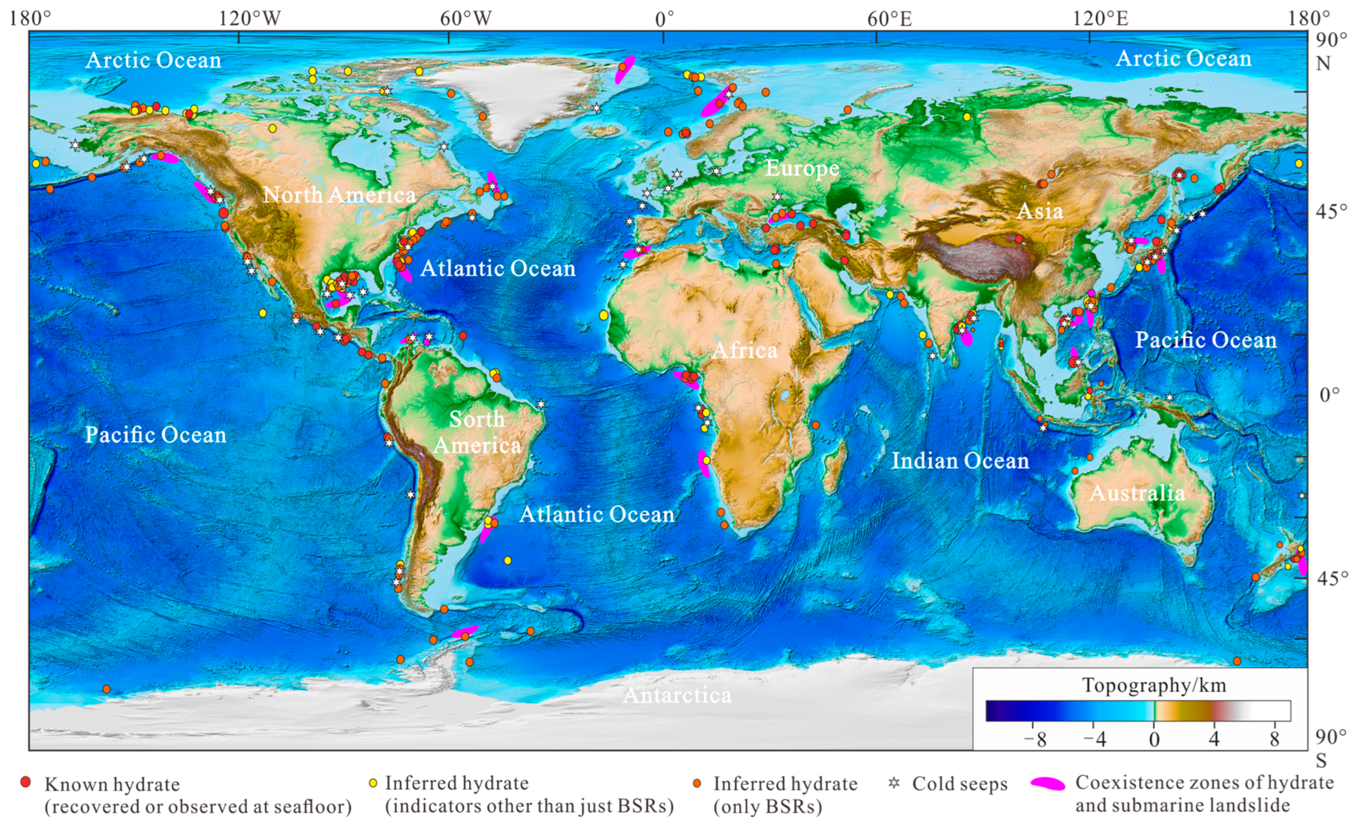
Figure 1. The distributions of gas hydrates (modified from [7]), cold seeps and the coexistence zones of submarine slides and gas hydrates in the world’s oceans.
Jmse 13 00308 g001
Figure 2. (a) Distribution map of submarine geological hazards in the Pearl River Mouth Basin of the South China Sea, including slides, slumps, MTDs (mass-transport deposits), BSR, faults, and volcanoes. (b) Seafloor topographic map of small-scale slump on the lower continental slope. The black line indicates the location of the seismic profile of Figure 3a.
Jmse 13 00308 g002
Figure 3. (a) Interpreted seismic profile through site W25 shows the relationship between seafloor slides, faults, and numerous enhanced reflections with pull-down below BGHSZ. (b) The overlay map of enhanced reflections and coherence attribute extracted from 3D seismic data showing indicating scars and free gas trapped below BGHSZ. The red lines show the locations of figures c and d. (c,d) Typical seismic profiles show scars of slides and high amplitude or enhanced reflections, respectively. H1–H4 are obvious reflection horizons.
Jmse 13 00308 g003
Figure 4. (a) Maximum amplitude attribute is extracted above base of gas hydrate stability zone (BGHSZ) with time windows of 100 ms; (b) the minimum amplitude attribute is extracted below BGHSZ with time windows of 50 ms. These attributes show the anomalies of amplitude related to gas hydrate, shallow gas, lithology change, and volcanoes in the Pearl River Mouth Basin.
Jmse 13 00308 g004
Figure 5. (a) Typical seismic profile through the head of submarine slide; (b) time map of seafloor topography; (c) Typical seismic profile across the head of submarine slide; (d) dip attribute shows the characteristics of head of slide in the slope break zone; location is shown in Figure 2.
Jmse 13 00308 g005
Figure 6. (a) 3D display of seismic section and root-mean-square (RMS) amplitude attribution extracted with time window of 40 ms above horizon 2.59 Ma (H1). Enhanced reflections are found on both sides of faults. The volcanic mounds and sills are identified at the bottom of deep faults. The red lines show the locations of Figures (bd). (b) Interpreted seismic section showing the characteristic of sediment waves and the collapse of the canyon sidewalls. (c) Interpreted seismic section showing the depression topography of seafloor. (d) Interpreted seismic section showing the relationship between sediment waves and enhanced reflections.
Jmse 13 00308 g006
Figure 7. (a) The seismic profile across various submarine geohazards; (b) the interpretation model diagrams of the Pearl River Mouth Basin showing the relationships between volcano complex (red zone), faults, shallow gas (blue zone), and gas hydrates (orange zone).
Jmse 13 00308 g007
Disclaimer/Publisher’s Note: The statements, opinions and data contained in all publications are solely those of the individual author(s) and contributor(s) and not of MDPI and/or the editor(s). MDPI and/or the editor(s) disclaim responsibility for any injury to people or property resulting from any ideas, methods, instructions or products referred to in the content.