Article

Assessment of the State of the Landscaping System in the City of Aktobe, the Republic of Kazakhstan, under Conditions of Man-Made Load Using Remote Sensing

by
Altynbek Khamit
1,
Nurlygul Utarbayeva
2,
Gulnur Shumakova
3,
Murat Makhambetov
2,
Akzhunus Abdullina
1 and
Aigul Sergeyeva
1,*
1
Department of Geography and Tourism, K. Zhubanov Aktobe Regional University, Aktobe 030000, Kazakhstan
2
Faculty of Natural Sciences, K. Zhubanov Aktobe Regional University, Aktobe 030000, Kazakhstan
3
Department of Geography and Ecology, Abai Kazakh National Pedagogical University, Almaty 050010, Kazakhstan
*
Author to whom correspondence should be addressed.
Urban Sci. 2024, 8(2), 34; https://doi.org/10.3390/urbansci8020034
Submission received: 6 March 2024 / Revised: 2 April 2024 / Accepted: 16 April 2024 / Published: 17 April 2024

Abstract

:
The growth of a city causes a complex of problems related to the increase in the pollution of the urban environment and the shortcomings in its improvement. The territory of the modern city is characterized by the highest man-made loads on the natural environment. The main problems are the low level of green areas, as well as the reduction in trees in many areas, which does not allow the city residents to live comfortably. Currently, Earth remote sensing methods using the vegetation index (NDVI) are one of the dominant means of assessing the condition. In this regard, the purpose of this study is to assess the ecological condition of the green zone in the city of Aktobe. To solve this problem, complex assessment was carried out, including statistical data analysis and the processing of satellite images by calculation of the NDVI for green areas and their mapping. The article analysis lies in the field of development and landscaping of the urban environment of Aktobe. A description of the current state of the system of green areas in the city was provided. On the basis of the data of remote sensing of the earth, the spatial features of the separate classes of the total phytomass of green plants within the city of Aktobe and the spatial features of the territorial zones of the city were determined during the differentiation of green plantings. A study of the dynamics of changes in the vegetation cover index (NDVI) during 2010, 2016, and 2023 allowed us to identify trends in the development of green spaces and their changes over time due to city growth and other factors. The data obtained as a result of the research can be used in the justification of urban planning decisions, landscape planning of the ecological infrastructure of the city, and optimization of landscaping systems.

1. Introduction

Green spaces in cities are very valuable objects for their sustainable development. They not only create an aesthetic appearance by decorating streets, parks, squares, and boulevards but also act as live filters. The leaves of trees have the properties of absorbing dust, neutralizing and reducing the amount of harmful substances in the air. The problem of a lack of vegetation and a lack of oxygenated air is becoming urgent in large cities where the number of new houses is growing at a great rate every year [1]. A lack of vegetation leads not only to an aesthetic problem when the whole city turns into a monotonous gray mass but also to an ecological problem when a small amount of green space negatively affects the local microclimate and ecology [2]. Green spaces in regulating the microclimate of the city play no less of an important role than the city planning itself. Trees and shrubs provide a significant reduction in wind speed, a high degree of shading of the area, freshen the air and increase its humidity, release oxygen and biocides, absorb nitrogen, sulfur, and carbon oxides, and settle dust, and they also have a beneficial effect on people [3].
Various heavy man-made loads on the natural environment create unfavorable living conditions for city dwellers. Active construction of residential and non-residential buildings and dense planning lead to a reduction in the green area, which leads to an aggravation of the ecological situation of the city and is the basis for the weakening of the natural–ecological infrastructure [4]. Ensuring the preservation of urban greenery should be considered an integral part of the urban landscape. However, anthropogenic impact on the state of city parks, flower beds, and alleys leads to a decrease in the quality of life of the population [5]. Atmospheric pollution, soil degradation, mechanical damage to land, increased building density, etc., leads to the deterioration of the city’s environmental condition and the health of city residents [6]. Public urban green spaces, such as urban parks, are usually the most important component of urban green spaces [7]. They are mainly controlled by state organizations and should be available to the public [8]. Many studies have been conducted in the field of green construction and landscape architecture [9]. The sanitary–hygienic, ecological, and aesthetic social functions of the green space are of great importance. New approaches aimed at the design of landscape diversity in landscaping cities are being formed [10]. At the same time, great importance is attached to parks, boulevards, and squares as a central center of stabilization and preservation of the natural environment, as well as green corridors that create the integrity of the street landscaping system [11].

Literature Review

A compact city has physical and institutional barriers that limit the quantity and quality of green space. Recent research results in urban forestry, urban ecology, and urban planning suggest alternative strategies for both existing and new green spaces [12,13]. An interdisciplinary interpretation highlights relevant principles and practices that promote the greening of densely populated areas and overcoming key constraints. Measures are proposed to protect green spaces from intensification to preserve both areas and conditions for plants, wildlife, and ecological functions [14].
In many cities of Kazakhstan, landscaped areas, such as parks, gardens, street landscaping, and green areas, are shrinking, and landscaped facilities for special purposes and limited use are being neglected. Currently, the unified urban gardening system, which is important for the cities of Kazakhstan as a whole, is declining. The severity of the problem is determined not only by the reduction in green areas but also by the poor selection of plants and their ecological flexibility and viability in the extreme conditions of the city, the quality of planting material, and the lack of qualified care [15]. The improvement of the ecological situation in cities develops in connection with the improvement of the landscaping system, which considers the placement of all components of landscaping in a scientifically based space in accordance with urban planning zones, climate, soil, and other factors in order to achieve optimal aesthetic, sanitary–hygienic, and ecological effects [16,17].
Landscaping is one of the major ways to improve an urban environment. While green trees are an essential element of the architectural landscape of every city, they perform a sanitary–hygienic function, as well as many other functions [18]. Complex urban conditions (ecological factors of local weather, air, and soil pollution) often have a negative effect on the normal growth of plants. As a result, leaves and brushes of urban plants are damaged, biological productivity decreases, and life time is shortened. Therefore, it is necessary to know not only the effect of plants on the urban environment but also the effect of that environment on woody plants [19,20].
The conflict between planting trees in urban areas and the negative impact of urban conditions on plants can be resolved by choosing a stable variety, using adapted growing material, creating conditions that promote the stability of trees, and following all agrotechnical procedures and rules for caring for growing trees. In addition, the change in a number of morphometric and physiological parameters can be used not only to determine the stability against man-made pollutants but also to evaluate the quality of the urban environment [21,22].
The stability of plants in urban conditions depends on the ability to change their physiological processes and the adaptability of the natural environment in protection from extreme factors. In this regard, the resistance of plants to industrial pollution depends on environmental factors (light, temperature, humidity, supply of nutrients) and the general state of life of the plant [23,24].
The formation of a unified and interconnected system of landscaping of the city is one of the effective means of maintaining the stability of the natural complex. Landscaping schemes include urban planning factors and standards of urban planning design, division of urban territory into functional planned zones, location of residential and industrial areas, means of communication, engineering infrastructure, etc., based on the draft proposals of the Master Plan [25,26].
Previous studies had limited coverage in assessing the state of the city’s greening system under conditions of man-made load. Some aspects were missed, such as the impact of technogenic factors on the health of residents, the environmental consequences of technogenic activity, and the effectiveness of green spaces in mitigating negative consequences [27,28,29].
The purpose of this study is to conduct a comprehensive assessment of the state of the city’s greening system under conditions of technogenic load using Earth remote sensing (ERS). This includes the following aspects:
-
The use of remote sensing data allows for obtaining information about the state of green areas and plantings in the city, such as parks, squares, alleys, forest parks, etc.;
-
Using remote sensing data, it is possible to identify changes in the structure and density of green spaces in the city over different periods of time, which makes it possible to assess the dynamics of changes and identify problem areas of the city;
-
The data obtained can be used to develop strategies for planning and managing green areas of the city, including optimizing the distribution of green spaces and their care and development.

2. Study Area

The city of Aktobe is a large and industrial city in the western region, the center of the region. The city is located in the central part of the pre-Ural plateau on a plain, with a height of 250–280 m. The area of the city is 2.3 thousand km2. The population of Aktobe is growing every year. The current population is 560,820 (in 2023), with 242 people per 1 km2 [30]. The main man-made factors affecting people’s health are the pollution of the natural environment (air, soil, water, vegetation) with emissions, including discharges of industrial enterprises and automobile gases.
The main polluting enterprises are the Aktobe Ferroalloy Plant, Aktobe Chromium Compounds Plant, Aktobe Thermal Power Center, etc. Due to the constant increase in the number of cars in the city, the amount of air-polluting gases is increasing. The impact of the private sector on the environment is studied less but it is also important [31]. In general, the level of recent research on the geoecological problems of Aktobe is low [32]. Due to the increase in production facilities in the city, environmental problems are becoming more complicated.
Green plantations in the city of Aktobe were mainly planted in 1950–1980 and currently cannot fulfill their multifunctional role due to increased man-made load. There is a lack of green spaces everywhere, and the system of green areas, which includes general, limited, and special-use plantings, is poorly developed. The relevance of the work is determined by the insufficient study of the problems of the functioning of green plantations under the growing man-made load and the urgent need to improve the landscaping of the city.

2.1. Natural–Climatic and Engineering–Geological Aspects of the City of Aktobe

The climate is sharply continental and is characterized by great variability in temperature, humidity, and other meteorological elements, both daily and annually. Aktobe is characterized by a harsh wind regime with an increased frequency of strong winds. The study area is characterized by high temperatures during the summer season. The average annual temperature range is from +25 to 27 °C. The average daily temperature in July is +25 °C. The maximum temperature reaches +40–42 °C. The duration of the warm period of the year is 236 days [33].
The clearer part of the year in Aktobe begins around 11 April and lasts 6.1 months, ending around 15 October. The clearest month of the year in Aktobe is July, during which the sky is clear on average, with variable cloudiness 73% of the time. The cloudier part of the year begins on 15 October and lasts 5.9 months, ending around 11 April. The growing season in Aktobe typically lasts 4.9 months (150 days), from approximately 2 May to 29 September, rarely starting before 10 April or after 24 May, and rarely ending before 11 September or after 17 October [34].
The territory is located in the Aktobe Urals on the surface of the extreme eastern part of the Ural–Emben plateau on the gently undulating surface of the first floodplain terrace of the Ilek River. The surface of the terrace is a slightly undulating plain with a general slope to the northwest and towards the bed of the Ilek River. Absolute elevations of the relief surface range between 209.8 and 210.1 m. According to hydrographic affiliation, the territory belongs to the basin of the Ilek River and its tributaries, the Kargala, Zhinishke, Tamdy, and Sazdy. The Aktobe reservoir was built on the Ilek River, and the Sazdy reservoir was built on the Sazdy River. The territory lies within the subzone of a moderate-dry steppe with dark chestnut soil. Landscaping is carried out by planting artificial plantings [35]. Regarding the dangerous geological and hydrogeological processes and phenomena in the city and newly developed areas, the following were noted:
-
Loams, sandy loams, and clays have subsidence properties in the city;
-
Slope processes characterized by widespread landslides;
-
Bottom and lateral erosion in riverbeds and gully erosion on slopes without permanent watercourses;
-
Swelling, leading to an increase in porosity and a decrease in soil strength;
-
Karst, dangerous phenomena leading to the formation of voids in the rock, often accompanied by cavities and the formation of craters on the surface.
The existing water supply to the city of Aktobe is provided by groundwater from alluvial deposits of the Ilek River valley and its tributaries (Kargaly, Tamdy, Sazdy). The total amount of groundwater reserves approved for domestic and drinking needs is 325.6 thousand m3/day, and unapproved reserves are 25.1 thousand m3/day [36].

2.2. Current Ecological Situation of Aktobe City

Every year in Aktobe, the number of new buildings grows and the city gradually expands its borders. In this regard, there is a need to create green spaces from which squares, neighborhood parks, alleys, or simply group or single plantings are formed. For landscaping in public places in the city, coniferous and deciduous trees, shrubs, and a wide variety of floral plants, both annual and perennial, are used. The main functions of green spaces are microclimatic, cleansing, recreational, sanitary and hygienic, and aesthetic. In this regard, in landscaping, preference is given to the decorative properties of plants and their stability and ability to adapt to the polluted environment of the city.
In the city of Aktobe, the low level of forest cover and the poor species composition of woody plants require careful selection of the assortment for protective afforestation and landscaping [37]. Changes in the urban environment due to the impact of pollutants from industrial enterprises, automobiles, and residential and communal complexes have worsened the growth, development, and condition of green spaces. In the last 20 years, the territory of the city of Aktobe has increased by 3.5 times. The air pollution index has increased. The history of gardening in Aktobe shows that soil–ecological conditions, along with climatic and anthropogenic conditions, are decisive factors in gardening.
One of the current problems is atmospheric air pollution in Aktobe city with hydrogen sulfide. The source of hydrogen sulfide pollution is the city’s sewage system. The concentration of hydrogen sulfide in sewage systems ranges between 2 and 16%. Sewage used by residents and separated from production facilities is collected in general city sewage treatment plants of JSC “Akbulak”. Pollution of the Elek River causes great harm to the local flora and fauna. In 2016, JSC “Akbulak” repaired sewage systems. This measure led to a sharp increase in the amount of hydrogen sulfide in the environment [38].
The city’s pollution level is also affected by the lack of or ineffective planning of container areas during the construction of new housing. As a result, the problem of chaotic accumulation of solid household waste and its disposal arises. The lack of areas for the collection of large household waste in the city leads to the creation of additional waste places. Currently, there is only one solid waste landfill with a total area of 20 ha in the city of Aktobe, which was introduced in 1987. Its service life was 25 years, and it was supposed to close in 2002. The condition of the landfill is unsatisfactory. The treated part is not covered with an insulating layer, which leads to the decay and decomposition of the waste. As a result, additional pollution of air, soil, and plant cover is taking place [39].
The urbanized territory of the city center is not the same in all areas, and environmental conditions change depending on the soil of different areas (level of soil and salinity, mechanical composition, type and consequences of anthropogenic influence: industrial and construction). That is why, along with the analysis of the amplitude of the ecological range of trees and shrubs, there is a need to divide the city into ecological districts, while determining the anthropogenic and limiting factors that inhibit the growth and development of plants.
General research objects are in the areas of Aktobe city that are used in common, such as city-wide parks, plantings on the streets, and plantings and squares of residential districts and districts of limited use, and for special purposes, sanitary protection zones of industrial enterprises (Figure 1) [40].

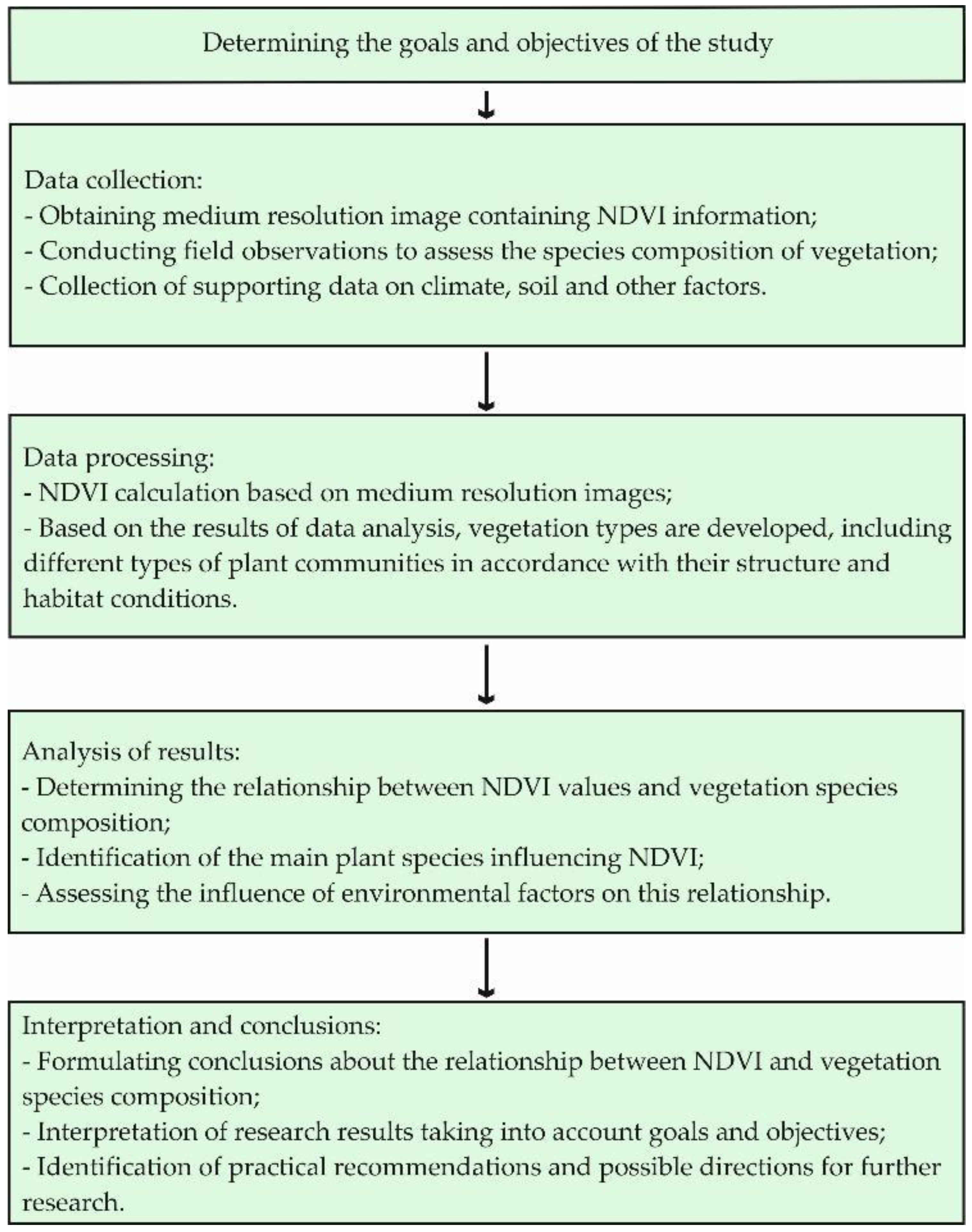
3. Materials and Methods

The purpose of the research is a comprehensive study of the current state of landscaping in large cities under conditions of technogenic load and the development of main directions for its improvement.
A flowchart of the research methodology for investigating the relationship between the NDVI and vegetation species composition is shown in Figure 2.
In the course of collecting material for this research work, a map of the General Plan of the city of Aktobe, data from the “Aktobe Institution for the Protection of Forests and Wildlife” of the state “Department of Natural Resources and Environmental Regulation of the Aktobe Region” and the Kazakh Research Institute of Forestry and Agroforestry named after A. N. Bokeikhan, West Kazakhstan branch for 2017–2019, were used.
In the first stage of this study, the number of green alder trees in Aktobe was counted and their living conditions were evaluated. In 2016–2018, 101,591 thousand trees and shrubs growing in 892 streets, 9 avenues, 71 dead-end streets, 3 parks, and 47 squares were studied.
Work on the inventory of green spaces in the city of Aktobe was carried out by specialists from the West Kazakhstan branch of the “Kazakh Research Institute of Forestry and Agroforestry” LLP in 2017–2019 on the territory of six microdistricts of the city of Aktobe (5th microdistrict, 8th microdistrict, 11th microdistrict, 12th microdistrict, Bolashak microdistrict, and Aviagorodok microdistrict). When making an inventory of green spaces, the composition was indicated, mainly by species, and entered into the taxation log indicating each tree seat in the surveyed area. The distribution of plantings by species composition is given in Table 1. As can be seen in Table 1, more than 30 species of trees and shrubs grow in the microdistricts.
Moreover, in order to solve many tasks of planning the greening of Aktobe city, on the basis of archival space images, dynamic monitoring of the state of green plantings was carried out. Earth remote sensing data were used to analyze the urban landscaping system. This makes it possible to determine quantitative and qualitative indicators of green areas of the city [41,42,43].
The normalized difference vegetation index (NDVI) is widely used to assess the condition of vegetation on the Earth’s surface based on data obtained from land remote sensing. It provides information about the health and density of plant cover. A relationship between the NDVI and vegetation species composition is generally present, although it can be ambiguous and depends on various factors, including climate, soil type, hydrological conditions, and anthropogenic impacts. The following are some key points linking the NDVI and vegetation species composition.
-
Higher NDVI values generally indicate healthier, denser vegetation. Different plant species may have different responses to changes in canopy density and composition, which may affect NDVI values;
-
Different types of vegetation have different NDVI characteristics. Wooded areas may have higher NDVI values compared to grassy or arid areas;
-
Vegetation species composition can influence temporal changes in the NDVI throughout the year. Different species have different periods of active growth and development, which may be reflected in changes in the NDVI at different times of the year;
-
Vegetation species composition can also be altered by human impacts, such as deforestation, soil and water pollution, and the introduction of invasive species. These changes may affect the NDVI.
In order to plan and optimize the green space, one must have a detailed understanding of the exact distribution of plants, their types, species composition, biomass, etc. [44,45]. In large cities, cadastres of green space are usually incomplete and not updated often. In addition, the functional condition of urban vegetation and its factors are not properly monitored. It is difficult to objectively monitor the condition of the “green” fund of Aktobe and study it by taking into account a large area of the city. Therefore, it is reasonable to use remote sensing data, such as multispectral satellite images. Often, in this case, they turn to a simple and informative indicator—the vegetation index (normalized difference vegetation index—NDVI) [46,47,48].
N D V I = ( N I R R E D ) ( N I R + R E D ) ,
where NIR is the reflection value in the near-infrared region of the spectrum and
RED is the reflection value in the red region of the spectrum.
High photosynthetic activity, mainly associated with a large phytomass of plants, results in low values of reflectance in the red region of the spectrum and large values in the near-infrared region [49,50]. In a simplified view, the NDVI indicates the presence of vegetation and the total relative phytomass. The NDVI is recommended for monitoring and assessing global vegetation status, as the scale helps to compensate for changes in light conditions, surface slope, exposure, and other external factors [51,52]. However, the NDVI is widely used to determine the vegetation status of urban areas, as well as to evaluate the temporal change in vegetation within the boundaries of microdistricts [53,54,55].
The existing experience of monitoring the changes in the area and characteristics of tree plantations in the city shows that changes in forest cover and productivity of forest areas can be successfully determined by the NDVI. With the help of the NDVI, changes in boundaries and characteristics of different types of vegetation were determined based on images at different times. Correlations were established between the NDVI and plant productivity of different ecosystems. In the case of satisfactory results of remote sensing data decoding, we can obtain a number of utilitarian characteristics of green plantations (total area, area of green plantations in separate areas, supply of green plantations, degree of greening, etc.).
Landsat-4–5, Landsat-8–9, and Sentinel-1/2 satellite images from June 2010, 2016, and 2023 were obtained using the sentinel-hub.com application in order to determine the condition of green zones in the city.
The spatial images were processed in ArcGIS 10.8, and geometric and atmospheric corrections were made. In 2010, high-resolution surveys were carried out with the Landsat-4–5 system, and in 2016, only the Landsat-8–9 system was used. In 2023, only images from the Sentinel-1/2 system were available, so the diversity and resolution of imaging systems between these years may affect the results of this study.
The NDVI calculation is based on the two most stable (independent of other factors) sections of the spectral reflectance curve of vascular plants. In the red region of the spectrum (0.6–0.7 μm) lies the maximum absorption of solar radiation by the chlorophyll of higher vascular plants, and in the infrared region (0.7–1.0 μm) is the region of maximum reflection of the cellular structures of the leaf. That is, high photosynthetic activity (usually associated with dense vegetation) leads to less reflection in the red region of the spectrum and more in the infrared. The relationship of these indicators to each other allows us to clearly separate and analyze plant objects from other natural objects. Using not a simple ratio but a normalized difference between the minimum and maximum of reflections increases the accuracy of the measurement and makes it possible to reduce the influence of phenomena, such as differences in image illumination, cloudiness, haze, absorption of radiation by the atmosphere, etc.
The NDVI can be calculated based on any high-, medium-, or low-resolution images that have spectral channels in the red (0.55–0.75 µm) and infrared range (0.75–1.0 µm). The NDVI calculation algorithm is built into almost all common software packages related to the processing of remote sensing data (Arc View Image Analysis, ERDAS Imagine, ENVI, Ermapper, Scanex MODIS Processor, ScanView, etc.).
Due to all these features, NDVI maps are often used as one of the intermediate additional layers for more complex types of analysis. The results can be maps of forest and agricultural land productivity and maps of landscape types, as well as vegetation and natural zones, soil, arid, phyto-hydrological, and other ecological and climatic maps. Also, on its basis, it is possible to obtain numerical data for use in calculations for assessing and forecasting crop yields and productivity, biological diversity, the degree of disturbance and damage from various natural and man-made disasters, accidents, etc.
In general, the main advantage of the NDVI is the ease of obtaining it. To calculate the index, no additional data or techniques are required other than the satellite imagery itself and knowledge of its parameters.
Data from Landsat and Sentinel-2B satellites are comparable when calculating the NDVI. This is due to the fact that the spectral characteristics of these satellites are similar. The main condition that must be observed to assess the state of vegetation using satellite data is to use images with the second level of processing (Level 2), at which geometric and radiometric correction was carried out and reflection values from the lower layers of the atmosphere were obtained [56].
To analyze the nature and density of vegetation, the work used remote sensing data, namely, satellite images in the red and near-infrared range. Sentinel 2 and Landsat 8/9 remote sensing missions were used. For Aktobe, 2 images from the Landsat 8/9 mission and 13 satellite images from the Sentinel 2 mission, dating from 2010 to 2023, were found and processed. The images were taken during the growing season (from May to June). The reason for selecting satellite images from May and June is that during this period, the growing season of vegetation is active. Thanks to this, we can clearly see areas with dense vegetation and carry out assessment work.
-
The methods make it possible to use remote sensing data to monitor the greening of urban areas. This includes the normalized difference vegetation index (NDVI) analysis to assess the health and density of vegetation on the ground’s surface;
-
The methods can help in identifying different types of vegetation in urban areas and classifying them. This allows us to study the structure and composition of landscaping in more detail and evaluate its diversity;
-
The methods can be used to evaluate the effectiveness of various measures for greening urban areas. The impact of planting new trees or creating green spaces on improving environmental quality can be assessed;
-
The methods can be integrated with other data sources, such as air pollution data, climate data, and soil quality data, to provide a more complete picture of the state of greenery and its impact on the environment.
Overall, the methods provide opportunities for more effective and detailed monitoring of the state of green spaces in urban areas, which can help city authorities and public organizations make more informed decisions on the management and development of green areas.
In the development of monitoring the state of greening in urban areas, there is always room for improvements and further development. Some of the potential weaknesses and needs in this area include the following:
-
To enable the identification and analysis of smaller items and plant structures, a higher spatial resolution of the data is required for a more thorough monitoring of the status of landscaping;
-
For a more accurate assessment of the state of landscaping, it is necessary to take into account seasonal changes and phenological characteristics of vegetation, as they can affect the values of the vegetation cover index (NDVI);
-
It is important to take into account the features of the urban environment, such as development, transport routes, infrastructure, and other factors that may affect the condition and effectiveness of landscaping;
-
To develop greening monitoring, it is necessary to take into account the needs and interests of various stakeholders, including city authorities, the population, public organizations, scientific researchers, and the business sector.
Addressing these weaknesses and meeting needs will create a more effective and comprehensively informed system for monitoring urban greening, promoting sustainable urban development, and improving the quality of life and the environment.

4. Results and Discussion

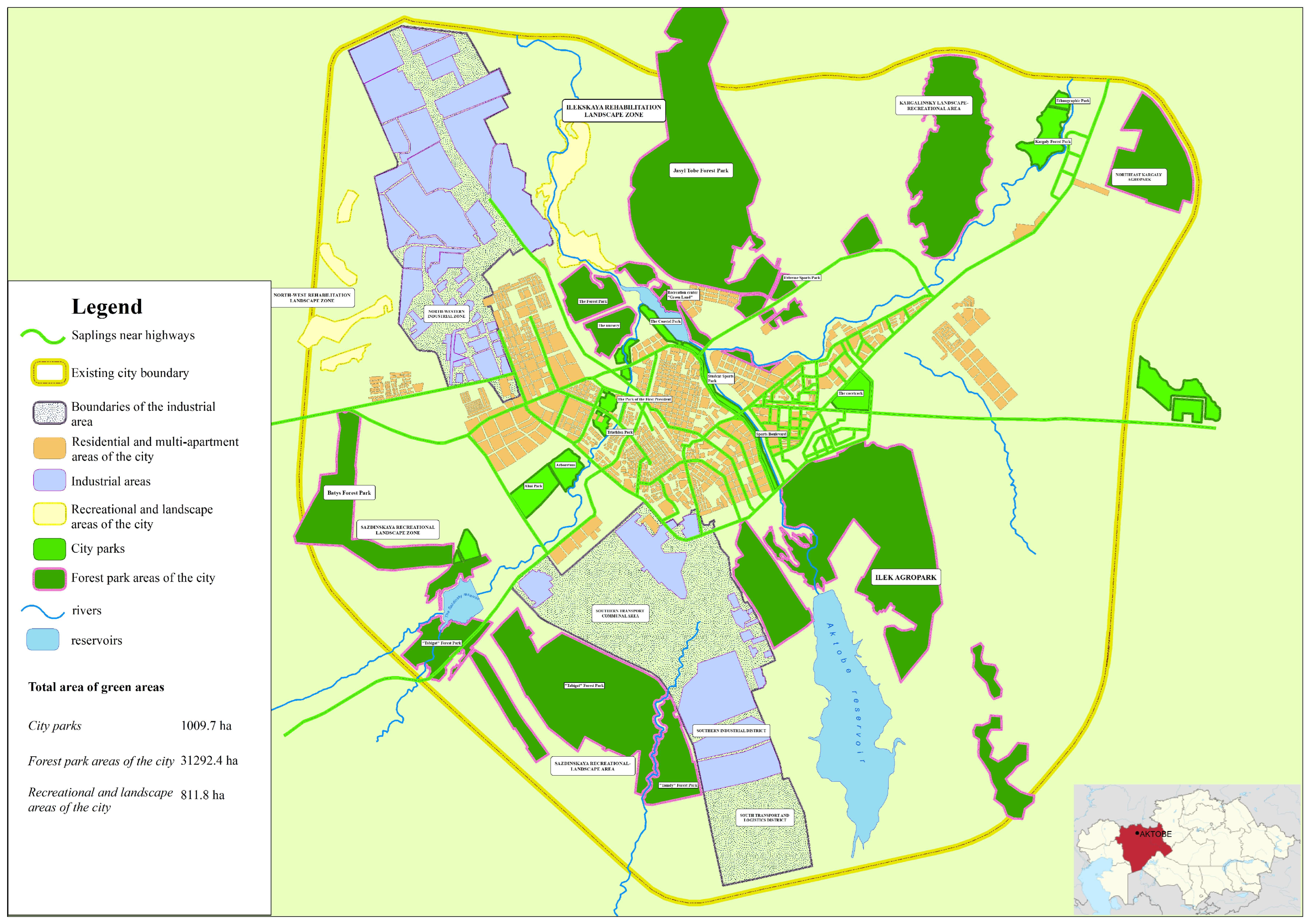
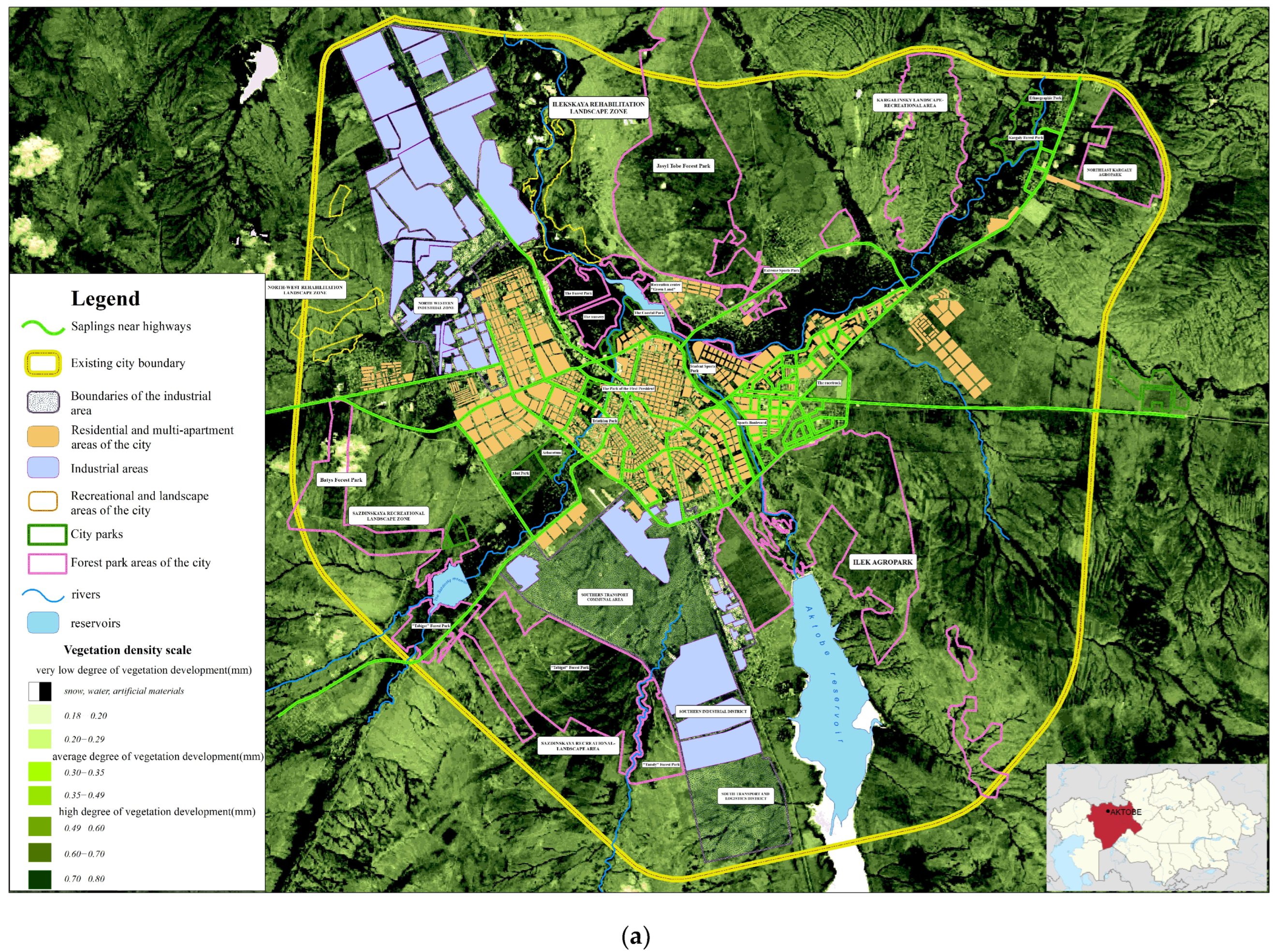
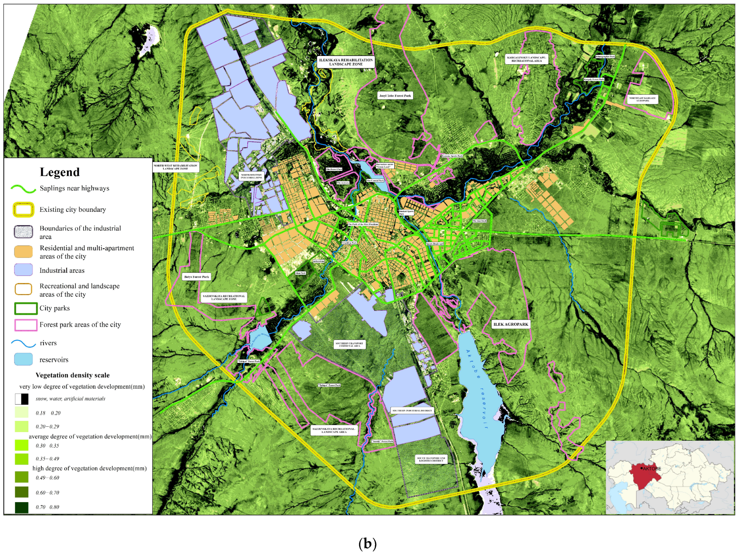
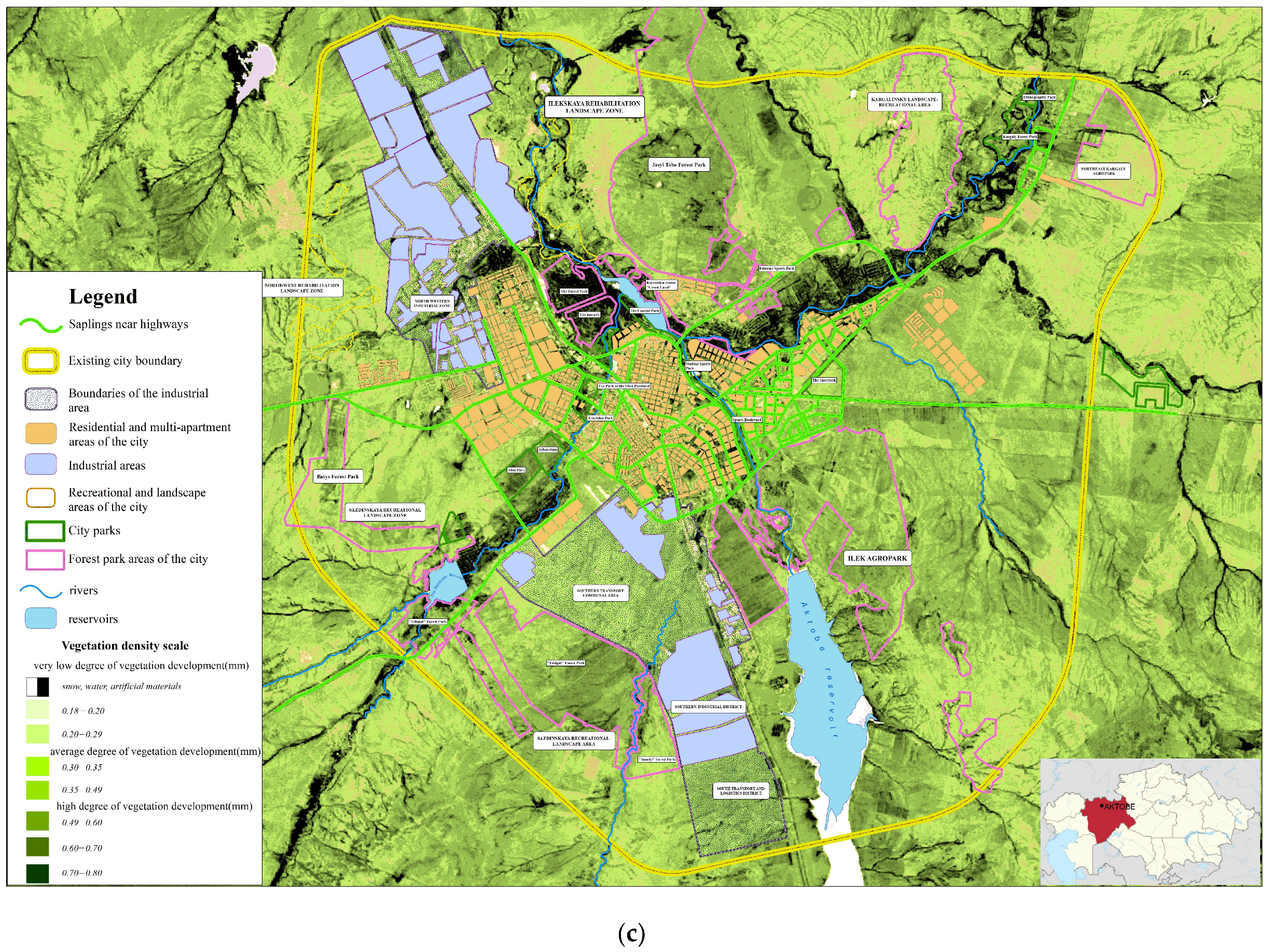
4.1. Condition of Green Zones in the City of Aktobe

According to the results of the NDVI, we can see that the distribution areas and dynamics of phytomass in the city are not uniform. Light green and yellow areas on the map indicate that the vegetation cover is “bare”. We note that these territories correspond to residential areas and the territory of production facilities, roadsides, and areas poor in vegetation. Vegetation cover in landscape zone plots outside the inner city area decreased from 9315 ha to 7920 ha in the period between 2010 and 2023. The reduction in phytomass in this amount is a clear negative trend, even taking into account the partial increase in forest strips and the growth of new seedlings.
Jasyl Tobe Forest Park is a 2847 ha green area in the northeastern part of Aktobe city. If we analyze the NDVI data, in 2010, the middle parts of the territory are given in dark green color, that is, we see that the vegetation cover of that territory is healthy (Figure 3).
In Table 2, the objects that have undergone major changes are Jasyl Tobe Forest Park, The Park of the First President, Kargaly Forest Park, Batys Forest Park, and Tabigat Forest Park.
The decline of the Jasyl Tobe Forest Park can be characterized by the expansion of the territories of the Aktobe Ferroalloys Plant and Aktobe Chromium Compounds Plant and the strong impact of man-made impacts.
In the period from 2010 to 2014, specialists and a private company were involved in the timely maintenance of the landscaping of the First President Park. In 2015, changes in the city administration led to the closure of this institution, as a result of which green spaces in the park area were not maintained, and in addition, sanitary pruning was carried out in an untimely way.
The reduction in landscaping in Kargaly Forest Park is due to the expansion of the Kargaly Riverbed without a plan or special regulations. In 2017–2018, flood prevention problems were solved by expanding river channels in the city. As a result, the thickets located along the banks of the river led to massive cutting down and destruction of ponds.
In 2016 and 2023, the color difference of the territory shows great differentiation. The main reason for the deterioration of the environment of green areas in this area can be justified by the fact that they are located close to the production facilities, and the area of pollution of the factory areas has increased.
In the territory of the city, two soil zones are distinguished: black soil (chernozem) and chestnut soil zones. Each of the zones, in turn, is divided into subzones that differ in soils, flora and fauna, and economic use. In the black soil zone, there is a subzone of southern black soils; in the chestnut zone, there is a dark chestnut and chestnut zone. Southern black soils occupy a small area in the western part of the city. Dark chestnut ones are most common in the city. The chestnut soil subzone occupies a small area in the west of the city.
The city’s plantings are mainly of artificial origin. In the harsh natural and climatic conditions of Aktobe, plantings, as a rule, are suppressed, and have low quality and low density. The species composition is not very diverse. The leading role in the composition of plantings belongs to Ulmus trees. These breeds are resilient, fast growing, and not demanding on growing conditions.
Significant areas of the State Forest Fund have been allocated on the territory of the city in order to organize a protective green belt and create recreation areas in riverine landscapes. Protective plantings around the city of Aktobe began to be created using the method of forest crops in 1946. The total area of the state forest fund is 192.5 thousand ha, of which the forested area is 40.3 thousand ha (20.9%). The species composition of state plantings consists mainly of Ulmus, Acer, Populus, Pinus, Haloxylon, Ribes, Caragana arborescens, Tamarix, Elaeagnus commutata, Calligonum, Betula, etc. Alnus glutinosa, Populus, Salix, Populus tremula, Salix acutifolia, Rosa canina, Prunus padus, etc., grow along the floodplains of the Ilek River.
The vegetation of the city is represented by plantings of parks, squares, boulevards, plantings at educational facilities, institutions, sports facilities, industrial enterprises, row plantings of trees and hedges along the streets, etc.
In the old town, middle-aged and old plantings predominate, and, therefore, require constant supervision since harmful insects and diseases affect them more often than young ones. In the new town, the plantings are mostly young. The condition of the plantings is mostly satisfactory. Areas with a total of trees and shrubs below 5% were combined and represented by the column “other”, which accounted for 11.63% (Figure 4).
The studied trees and some types of shrubs are found in almost all areas of the city and are shown in Figure 5.
To accurately assess diversity in the city of Aktobe, an analysis of the occurrence of species in the city in 2017–2019 was carried out. The results of the analysis showed that only eight of the sevety species that make up the city’s greenery are “very common” and “frequent”. According to the number of species, it was found that 88% of all urban seedlings belong to Ulmus pinnato-ramosa, Acer negundo, Populus tremula, Syringa vulgaris, Ribes aureum, Populus laurifolia, Populus nigra, and Rosa laxa. It was found that 32 species (10% of all species) belong to the category of “rare” species. In the category of “very rare” species, 27 trees and shrubs were identified, which made up 2.1% of all woody plants in the city.
Plants of this group are often found in gardens, lawns of schools and kindergartens, and new small districts. Such species include Picea pungens, Picea obovata, Larix sibirica, Betula pendula, Crataegus sanguinea, Amelanchier spicata, Caragana arborescens, Lonicera tatarica, and others. Only three types of species that do not make a significant difference to the green construction of the city were shown, such as Alnus glutinosa, Salix caprea, and Amygdalus nana. These species are resistant to urban conditions and look good in a row of lawns. Thus, Ulmus pinnato-ramosa (52%) and Acer negundo (21.4%) form the basis of the city’s greenery. Although less in number, Populus tremula (5%) and Syringa vulgaris (4.18%) complement the city landscaping. Their contributions are shown in Figure 6.
Determining the relative living conditions of trees and shrubs allows for an integral assessment of environmental factors affecting all plants. By assessing the relative living conditions of trees and shrubs (levels of damage), it is possible to assess the stability of individual trees and seedlings under the influence of natural and man-made factors.
The city pays considerable attention to floral decoration; however, its architectural and artistic level is not high enough. A significant drawback of urban greening is the lack of vertical gardening. Gardening groups make a significant contribution to the creation of green spaces. They are located in floodplains of rivers on irrigated lands. In total, there are 330 gardening groups in the city, which unite 25,035 owners of gardening plots. The total area they occupy is 1879.5 hectares. Natural plantings in the city and its environs grow mainly in the floodplains of the Ilek, Tamdy, and Sazdy rivers and are represented by Salix and Populus. To reduce the negative impact of climatic conditions, it is necessary to create a complex of protective plantings that create the necessary microclimate of the urban area.
The system of public plantings consists of plantings of citywide importance and plantings of planning and residential areas. For the most part, these plantings are represented by small islands of greenery and are not connected into a single system. The most significant elements of the system are the Central City Park named after Abai in the Sazdy planning area and Pushkin Park in the Ilek planning area (in the old town).
Sanitary protective plantings are important for isolating residential areas from large industrial zones, individual enterprises, and transport routes. Special-purpose plantings include plantings along city streets and green railroad right of way.
The positive qualities of the landscaping system in the city of Aktobe include the following:
-
The presence of large forest parks on the threshold of the city, performing protective functions, which are planned to be combined into a forest park belt;
-
The presence of a large Central Park named after Abai and the First President Park in the urban environment in the geometric center;
-
The tradition of creating boulevards;
-
High quality of individual elements of the landscaping system (Karasai Batyr Boulevard, Koblandina Street);
-
Availability of special-purpose plantings along most streets and external roads. Landscaping of individual sections of the railway right of way;
-
The presence of the forest park belt is still in the form of fragments not connected with each other. The forest park belt has significantly improved microclimatic conditions in the city. Planting the Jasyl Tobe Forest Park reduced the transfer of dust and sand to the historical part of the city;
-
Latitudinal boulevards in the Sazdy planning area should be considered as barriers to the spread of harmful emissions and should protect residential development from the negative impact of the northern industrial zone.
Considering the location of the bulk of industrial enterprises, including the most environmentally hazardous ones, in the northern part of the city, wide green boulevards are of greatest importance as protection against the spread of harmful substances. Such barriers include boulevards along Mira Avenue, Makhambetov Street (where the House of Culture is near the building of the Aktobe Chromium Compounds Plant), Abay Avenue, the boulevard along A. Moldagulova Avenue, 101 Rifle Brigade Street, M. Ospanova Street, and the city park in the floodplain of the Sazdy River.
In sanitary protection zones, the share of Ulmus is 70%, Populus is 18%, Acer is 8%, and Betula is 4%. The remaining species are represented insignificantly. Under conditions of abnormally high temperatures and in the absence of irrigation, a decline in woody plants is observed, even with annual planting.

4.2. Characteristics of Key Objects in Public Use

An analysis of satellite images of urban park areas showed a decrease in areas with woody vegetation by 1.2–1.7% per year. The tree species that form the basis of parklands (Populus balsamifera, Ulmus pumila) show signs of drying out at the age of 36–40 years and require replacement. Betula pendula showed signs of drying out at an earlier age—21 years.
Studies have shown that in the case of industrial pollution, the relative living conditions of trees and shrubs decrease. A visual analysis of the living conditions of green flagella on the crown showed that 53% of the studied trees belong to the category of “healthy” trees, that is, there is no external damage to the head and trunk of the tree; dead and damaged branches are located in the lower part of the crown, and slight damage to the leaves and needles does not affect the condition of the whole tree.
A total of 43% of trees and shrubs have various damages that have reduced their living conditions by 30–60%. A total of 3% of the plants belong to the “dead tree” category. The crown of trees of this category is damaged, and its thickness is 15–20% lower than that of healthy trees; more than 70% of the crown branches are dry or dying (including the upper part of the tree), and 1% of the total number is occupied by “dried out” trees and bushes (Figure 7).

4.3. Zoning of Green Areas and Analysis of Their Level of Greening and the Influence of Stationary and Mobile Sources of Pollution

Based on the mapping of green areas in Aktobe, a scale of provision of green areas was developed depending on standard urban planning indicators. The density of green areas was calculated. It is presented in 4 levels: 1. High density: 70–50%; 2. Average density: 50–30%; 3. Low density: 30–15%; 4. Very low density: 15–5% (Figure 8).
Let’s analyze these levels of landscaping:
1. High Density (70–50%): This level suggests that there is a significant amount of green space in the urban environment, which can help improve air quality, reduce the city’s heating effect and improve the overall well-being of city residents;
2. Average Density (50–30%): At this level, the density of green space may be lower, but is still considered satisfactory. However, additional landscaping may be required to maintain and improve the quality of the urban environment;
3. Low Density (30–15%): This level indicates that there is significantly less green space in the city than at previous levels. This can lead to deterioration of air quality, increased heat load and a decrease in the aesthetic perception of the environment;
4. Very low density (15–5%): At this level, the amount of green space is extremely insufficient to maintain a healthy and pleasant urban environment. This can lead to serious environmental problems, including air pollution, decreased quality of life and increased vulnerability to climate change.
It was revealed that the maximum permissible level of load on roadside plantings was exceeded, depending on the volume of traffic flow, by 1.50–3.41 times for interchanges and 2.58–3.55 times for transport routes.
Multi-row planting of trees and shrubs reduces the degree of air pollution. A study of noise load on highways showed that the noise protection effect depends on the size, density, and structure of the tree crown. In areas with two- and three-row plantings, the noise level is reduced to a minimum comfortable level.
Due to the close location of sanitary protection zones to sources of negative impact on the city’s ecosystem, it is relevant to create a unified sanitary protection zone, the border of which should be established according to the following design documents: from enterprises in the northeastern and central regions of the industrial zone, along the sanitary protection border zone with enterprises, on the border with residential buildings.
Thus, the formation of a system of green areas in large cities is aimed at the following:
-
Transformation of the natural component of the urban area; maximum preservation and use of the green space system;
-
Creation, development, and adaptation of new green areas in accordance with the functions and nature of the planning organization of urban areas as a landscaping system;
-
Organization of buffer zones separating residential buildings from industrial and communal areas; architectural and planning transformation of natural areas for use for recreational purposes;
-
Regular monitoring, stocktaking, and maintaining a register of landscaping objects.
Green space systems are the main means of improving industrial cities. The existing systems of green spaces in Aktobe do not sufficiently fulfill their intended purpose and the main function of improving the health of the urban environment. The most objective reason is the lack of green space; they were planted according to standards developed in the 1950s–1980s, which aimed for a lower level of pollution and are not adapted to modern conditions.
The leading environmental factor that sharply limits the range of tree species is the high content of easily soluble salts and sodium in the soil. The condition of the plantings is also affected by the air basin saturated with various production wastes. Therefore, for the promising and successful cultivation of plantings in this zone, it is necessary that the plants have complex resistance to numerous unfavorable environmental factors.
The planning structure of modern Aktobe is characterized by a number of significant shortcomings, which include the following:
-
Placement of auxiliary industrial, warehouse, and utility structures, individual orchards, and vegetable gardens in the floodplain of the Ilek River;
-
The artificial expansion of riverbeds led to damage to the root systems of trees on the banks, which led to their death;
-
Isolated placement of existing parks that have not formed into a single system of interconnected plantings;
-
The uniformity of urban plantings creates a risk of vulnerability to diseases and insects;
-
Lack of landscaped embankments on the Ilek and Sazdy Rivers;
-
Incompleteness of the forest park belt around the city and boulevards;
-
Uneven distribution of public plantings throughout the city and their almost complete absence in Otorvanovka;
-
Low level of improvement of limited-use plantings on the territories of public institutions, educational institutions, etc.;
-
The appearance of unauthorized development on the territory of green spaces, and the construction of buildings blocking traffic along the boulevards;
-
The gradual development of the green belt bordering Zhilgorodok in the new town. Residential buildings and garages currently appear on its territory and have also appeared in previous years;
-
Unsuccessful placement of a residential building on the street. Sherniyaz blocked Karasai Batyr Boulevard. The small canal passing through the territory of microdistricts 4 and 5 is littered and not landscaped;
-
Lack of connection between intra-city green spaces with the forest park belt around the city, as well as with floodplain areas within the city. The existing boulevards are mainly sections of relatively short length and are not connected to the floodplains of the rivers or each other.

5. Conclusions

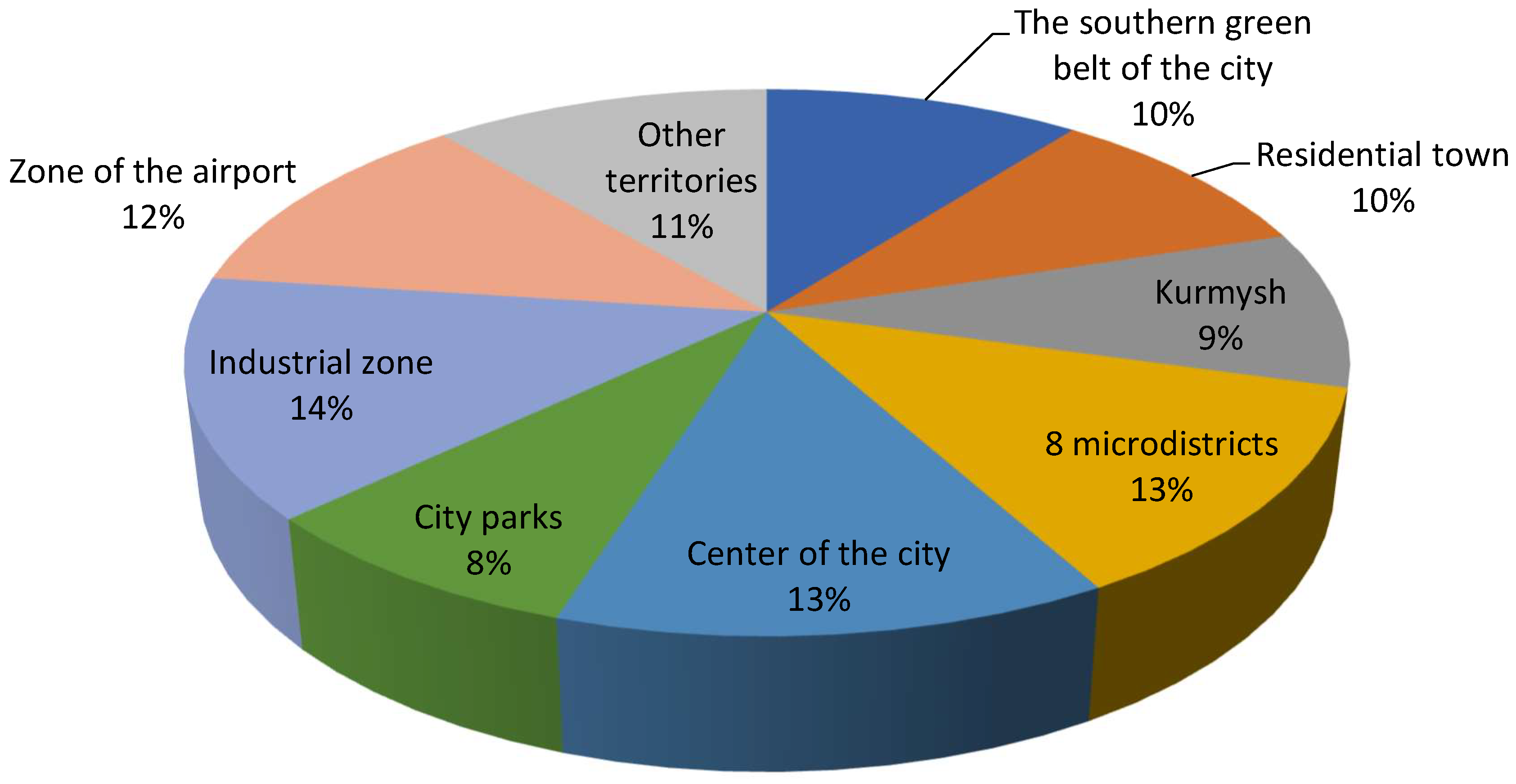
  • According to the data, it was revealed that the system of green areas in Aktobe is unevenly distributed. The planting area is 62.4% of the minimum norm.
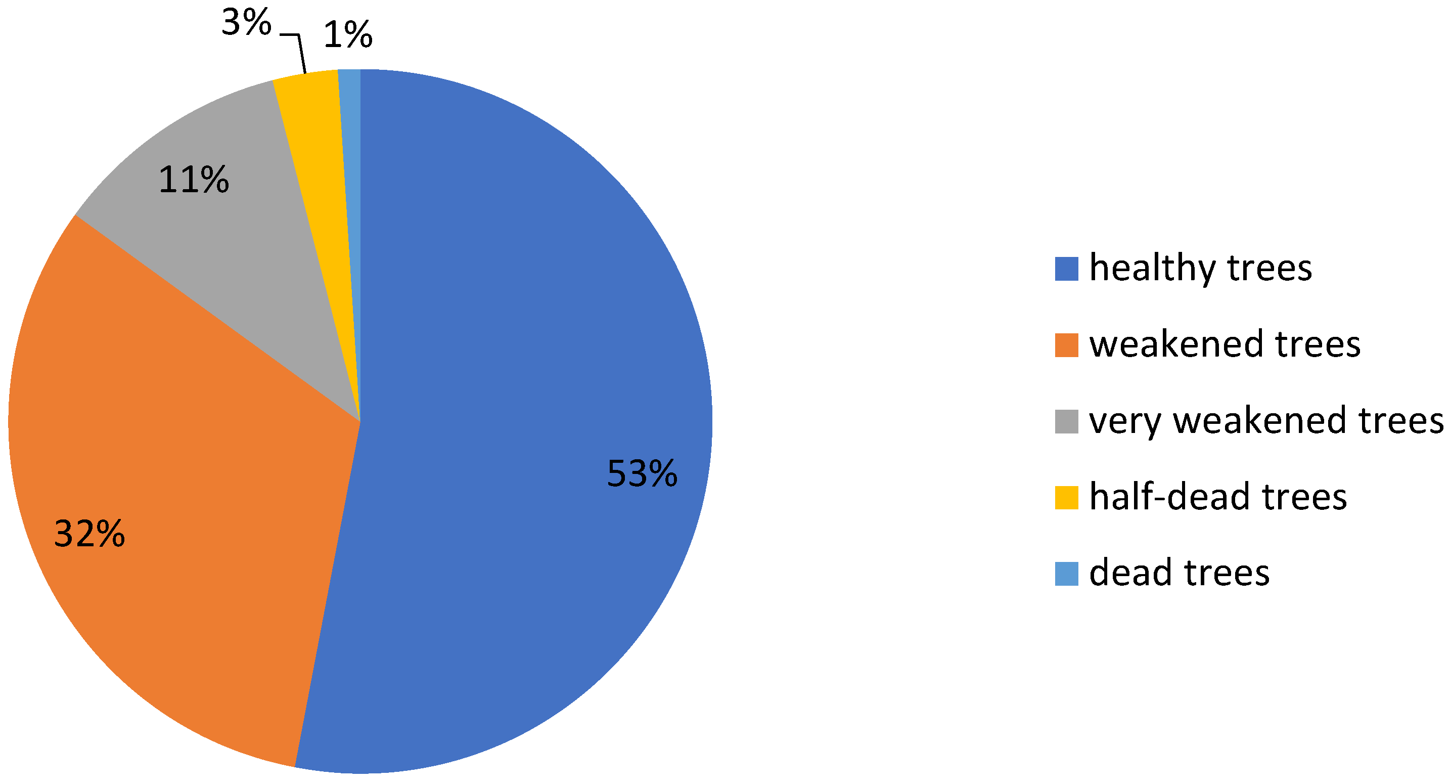
  • A comprehensive assessment of the greening of urban areas showed areas with an insufficient level of greening (541 hectares—72% of the residential area). The dynamics of planting green spaces over the years demonstrate the decline and low survival rate of plants due to natural and anthropogenic factors.
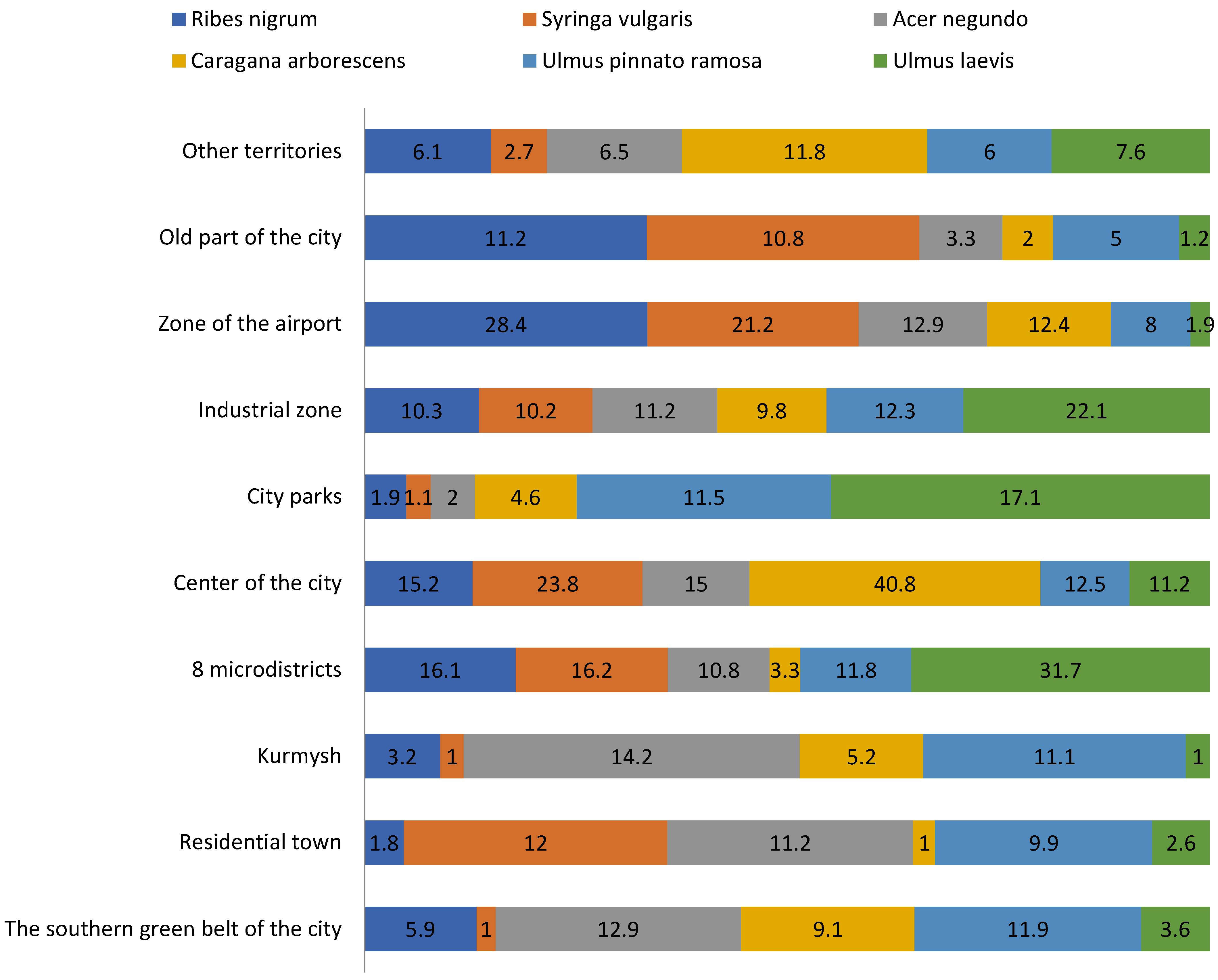
  • The following are common in public and limited-use plantings: hybrids of Ulmus, Populus, Acer, and Betula. The growth dynamics of Ulmus pumila on various objects show a decrease in growth from 10 to 13 cm in plantings aged 20–25 years to an increase of 5–7 cm in plantings over 40 years old.
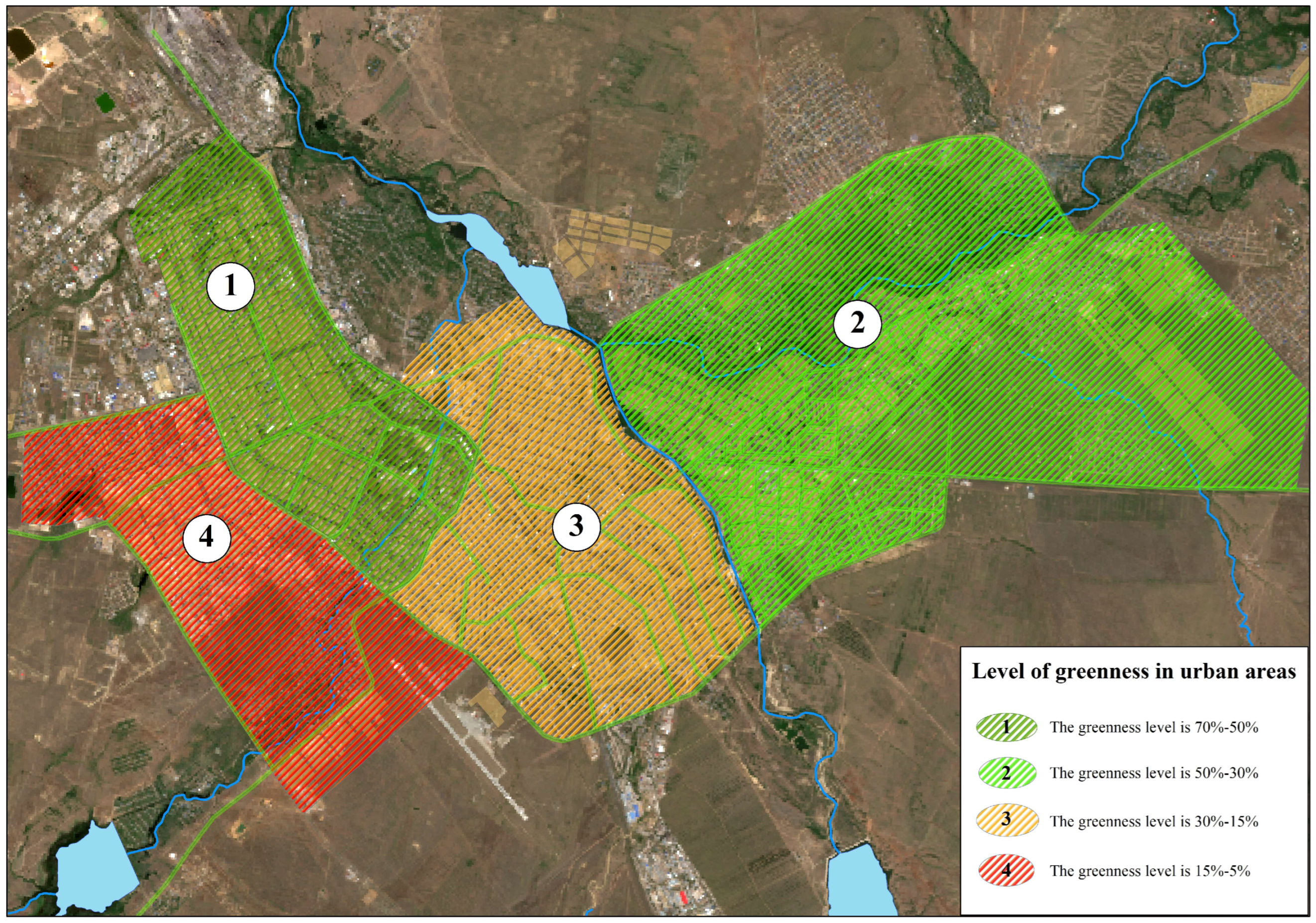
  • It is proposed to map urban areas according to the level of greenery at levels of high (0.40–0.42), medium (0.22–0.35), and low (0.10). A scale has been developed for determining the provision of green areas based on mapping and standard indicators. The scale is presented in six gradations: 1—sufficient (80–100% of standard indicators); 2—conditionally sufficient (60–80%); 3—transitional (50–60%); 4—insufficient (40–30%); 5—acutely insufficient (<30%); and 6—extremely insufficient (<20%).
  • The studied sanitary protection zones of industrial enterprises have insufficient areas and proportions of plantings. Four main polluting areas of the city of Aktobe were identified: the Aktobe Chromium Compounds Plant, the Aktobe Ferroalloys Plant, the industrial zone, and the city’s Aktobe Thermal Power Center Station. These polluting facilities should play an important role in the formation of the city’s sanitary protection zone.
  • The main transport junctions and highways of the city are sources of additional technogenic impact on green spaces due to the summation of emissions from stationary and mobile sources. With a load of 1.2–3.7, the condition of the soil cover generally satisfies sanitary and hygienic requirements.
  • As a result of the research, it has been proven that the creation of a system of green areas is based on the principles of diversification of the components of unified systems. It is based on the preservation of natural vegetation, primary landscaping, the reconstruction of existing plantings and improvement of objects in unsatisfactory condition, the preservation and adaptation to new living conditions, the organization of buffer zones, and the transformation of natural areas for recreational purposes.

Author Contributions

Conceptualization, A.S.; methodology, A.K. and A.S.; software, N.U. and A.K.; validation, G.S. and A.A.; formal analysis, A.K., N.U. and A.S.; investigation, M.M., G.S. and A.A.; resources, M.M., G.S. and A.A.; data curation, N.U.; writing—original draft preparation, A.S. and A.K.; writing—review and editing, G.S. and M.M.; visualization, A.K. and A.A.; supervision, A.S.; project administration, A.S.; funding acquisition, A.S., A.K., A.A., G.S., M.M. and N.U. All authors have read and agreed to the published version of the manuscript.

Funding

This research received no external funding.

Data Availability Statement

Databases with respective sources and references were described in the Section 3.

Conflicts of Interest

The authors declare no conflicts of interest.

References

  1. Jim, C.Y. Sustainable urban greening strategies for compact cities in developing and developed economies. Urban Ecosyst. 2013, 16, 741761. [Google Scholar] [CrossRef]
  2. Li, F.; Wang, R.; Paulussen, J.; Liu, X. Comprehensive concept planning of urban greening based on ecological principles: A case study in Beijing, China. Landsc. Urban Plan. 2005, 72, 325–336. [Google Scholar] [CrossRef]
  3. Esmail, B.A.; Cortinovis, C.; Suleiman, L.; Albert, C.; Geneletti, D.; Mörtberg, U. Greening cities through urban planning: A literature review on the uptake of concepts and methods in Stockholm. Urban For. Urban Green. 2022, 72, 127584. [Google Scholar] [CrossRef]
  4. Alpaidze, L.; Salukvadze, J. Green in the City: Estimating the Ecosystem Services Provided by Urban and Peri-Urban Forests of Tbilisi Municipality, Georgia. Forests 2023, 14, 121. [Google Scholar] [CrossRef]
  5. Pleshkanovska, A.M. Assessing the level of greening in a major city: Subjective and objective evaluation on the example of the city of Kyiv. Bull. Geogr. Socio-Econ. Ser. 2020, 48, 155–164. [Google Scholar] [CrossRef]
  6. McKendry, C.; Janos, N. Greening the industrial city: Equity, environment, and economic growth in Seattle and Chicago. Int. Environ. Agreem. Politics Law Econ. 2015, 15, 45–60. [Google Scholar] [CrossRef]
  7. Orîndaru, A.; Constantinescu, M.; Țuclea, C.E.; Căescu, Ș.C.; Florescu, M.S.; Dumitru, I. Rurbanization—Making the City Greener: Young Citizen Implication and Future Actions. Sustainability 2020, 12, 7175. [Google Scholar] [CrossRef]
  8. Alavi, S.A.; Esfandi, S.; Khavarian-Garmsir, A.R.; Tayebi, S.; Shamsipour, A.; Sharifi, A. Assessing the Connectivity of Urban Green Spaces for Enhanced Environmental Justice and Ecosystem Service Flow: A Study of Tehran Using Graph Theory and Least-Cost Analysis. Urban Sci. 2024, 8, 14. [Google Scholar] [CrossRef]
  9. Russo, A.; Cirella, G.T. Modern compact cities: How much greenery do we need? Int. J. Environ. Res. Public Health 2018, 15, 2180. [Google Scholar] [CrossRef]
  10. Zhumadina, S.; Chlachula, J.; Zhaglovskaya-Faurat, A.; Czerniawska, J.; Satybaldieva, G.; Nurbayeva, N.; Mapitov, N.; Myrzagaliyeva, A.; Boribay, E. Environmental dynamics of the ribbon-like pine forests in the Parklands of North Kazakhstan. Forests 2022, 13, 2. [Google Scholar] [CrossRef]
  11. Danford, R.S.; Strohbach, M.W.; Warren, P.S.; Ryan, R.L. Active Greening or Rewilding the city: How does the intention behind small pockets of urban green affect use? Urban For. Urban Green. 2018, 29, 377–383. [Google Scholar] [CrossRef]
  12. Jim, C. Green-space preservation and allocation for sustainable greening of compact cities. Cities 2004, 21, 311–320. [Google Scholar] [CrossRef]
  13. Sturiale, L.; Scuderi, A. The Evaluation of Green Investments in Urban Areas: A Proposal of an eco-social-green Model of the City. Sustainability 2018, 10, 4541. [Google Scholar] [CrossRef]
  14. Kronenberg, J. Why not to green a city? Institutional barriers to preserving urban ecosystem services. Ecosyst. Serv. 2015, 12, 218–227. [Google Scholar] [CrossRef]
  15. Wojcik, W.; Adikanova, S.; Malgazhdarov, Y.A.; Madiyarov, M.N.; Myrzagaliyeva, A.B.; Temirbekov, N.M.; Junisbekov, M.; Pawłowski, L. Probabilistic and statistical modelling of the harmful transport impurities in the atmosphere from motor vehicles. Rocz. Ochr. Sr. 2017, 19, 795–808. Available online: https://bibliotekanauki.pl/articles/1813898 (accessed on 25 December 2023).
  16. Hudzevych, A.V.; Nikitchenko, L.O.; Hudzevych, L.S.; Bronnikova, L.F.; Demets, R.O. Approaches to organize the econetwork of the Transnistria region in the conditions of urban landscape. J. Geol. Geogr. Geoecology 2021, 30, 449–459. [Google Scholar] [CrossRef]
  17. Jian, Z.; Hao, S. Geo-spatial analysis and optimization strategy of park green space landscape pattern of Garden City—A case study of the central district of Mianyang City Sichuan Province. Eur. J. Remote Sens. 2020, 53, 309–315. [Google Scholar] [CrossRef]
  18. Klimanova, O.; Illarionova, O.; Grunewald, K.; Bukvareva, E. Green infrastructure, urbanization, and ecosystem services: The main challenges for Russia’s largest cities. Land 2021, 10, 1292. [Google Scholar] [CrossRef]
  19. Porfiriev, B.N.; Dmitriev, A.; Vladimirova, I.; Tsygankova, A. Sustainable development planning and green construction for building resilient cities: Russian experiences within the international context. Environ. Hazards 2017, 16, 165–179. [Google Scholar] [CrossRef]
  20. Tian, Y.; Jim, C.Y.; Wang, H. Assessing the landscape and ecological quality of urban green spaces in a compact city. Landsc. Urban Plan. 2014, 121, 97–108. [Google Scholar] [CrossRef]
  21. Nistor, M.; Nicula, A.S.; Haidu, I.; Surdu, I.; Carebia, I.; Petrea, D. GIS Integration Model of Metropolitan Area Sustainability Index (MASI). The Case of Paris Metropolitan Area. J. Settl. Spat. Plan. 2019, 10, 39–48. [Google Scholar] [CrossRef]
  22. Xie, J.; Luo, S.; Furuya, K.; Sun, D. Urban parks as green buffers during the COVID-19 pandemic. Sustainability 2020, 12, 6751. [Google Scholar] [CrossRef]
  23. Vîlcea, C.; Șoșea, C. A GIS-based analysis of the urban green space accessibility in Craiova city, Romania. Geogr. Tidsskr. -Dan. J. Geogr. 2020, 120, 19–34. [Google Scholar] [CrossRef]
  24. Păcurar, B. How Green are Romania’s Cities? A Quarter—Century of Green Area Policy. J. Settl. Spat. Plan. 2017, 8, 71–77. [Google Scholar] [CrossRef]
  25. Narh, S.N.; Takyi, S.A.; Asibey, M.O.; Amponsah, O. Garden city without parks: An assessment of the availability and conditions of parks in Kumasi. Urban For. Urban Green. 2020, 55, 126819. [Google Scholar] [CrossRef]
  26. Shahtahmassebi, A.R.; Li, C.; Fan, Y.; Wu, Y.; Lin, Y.; Gan, M.; Wang, K.; Malik, A.; Blackburn, G.A. Remote sensing of urban green spaces: A review. Urban For. Urban Green. 2021, 57, 126946. [Google Scholar] [CrossRef]
  27. Buchavyi, Y.; Lovynska, V.; Samarska, A. A GIS Assessment of the Green Space Percentage in a Big Industrial City (Dnipro, Ukraine). Ekológia 2023, 42, 89–100. [Google Scholar] [CrossRef]
  28. Li, W.; Saphores, J.; Gillespie, T. A comparison of the economic benefits of urban green spaces estimated with NDVI and with high-resolution land cover data. Landsc. Urban Plan. 2015, 133, 105–117. [Google Scholar] [CrossRef]
  29. Aryal, J.; Sitaula, C.; Aryal, S. NDVI Threshold-Based Urban Green Space Mapping from Sentinel-2A at the Local Governmental Area (LGA) Level of Victoria, Australia. Land 2022, 11, 351. [Google Scholar] [CrossRef]
  30. Summary of the Socio-Economic Development of the Region; Bureau of National Statistics Agency for Strategic Planning and Reforms of the Republic of Kazakhstan: Aktobe, Kazakhstan, 2023. Available online: https://stat.gov.kz/en/region/aktobe/ (accessed on 19 December 2023).
  31. Sergeyeva, A.; Khamit, A.; Koshim, A.; Makhambetov, M. Ecological State Assessment of Urban Green Spaces Based on Remote Sensing Data. The Case of Aktobe City, Kazakhstan. J. Settl. Spat. Plan. 2021, 12, 83–92. [Google Scholar] [CrossRef]
  32. Utarbayeva, N.; Abiyev, S.; Aipeisova, S.; Bodykova, I.; Kazkeev, E.; Amanova, R. Heavy metal accumulation capacity of trees grown in the Aktobe city (Republic of Kazakhstan). Biosci. Res. 2018, 15, 4012–4019. Available online: https://elibrary.ru/item.asp?id=38702272 (accessed on 19 December 2023).
  33. Agroclimatic Resources of the Aktobe Region: Scientific and Applied Reference Book; Institute of Geography Republic of Kazakhstan, redaktor Baisholanov, S.S.: Astana, Kazakhstan, 2017; p. 137.
  34. Information Bulletin on the State of the Environment in the Aktobe Region; Republican State Enterprise “Kazhydromet”: Astana, Kazakhstan, 2022; p. 40. Available online: https://www.kazhydromet.kz/uploads/files_calendar/1744/file/6218ba528fb77aktobe-byulleten-za-yanvar-2022.pdf (accessed on 22 December 2023).
  35. Utarbayeva, N.; Aipeisova, S.; Maui, A.; Kazkeev, E.; Bimagambetova, G.; Kukenov, Z. Pollen morphology of broadleaf trees growing in different health conditions in the city of Aktobe. Environ. Control Biol. 2021, 59, 135–139. [Google Scholar] [CrossRef]
  36. Berdenov, Z.G.; Wendt, J.A.; Safarov, R.; Ozgeldinova, Z. Factors of formation of steppe landscapes of Aktobe region. J. Geogr. Environ. Manag. 2023, 4, 12–20. [Google Scholar] [CrossRef]
  37. Utarbayeva, N.A.; Aipeisova, S.A. Preliminiry results of the study of dendroflora of Aktobe city (Republic of Kazakhstan). Acta Biol. Sib. 2016, 2, 118–123. Available online: https://cyberleninka.ru/article/n/predvaritelnye-itogi-izucheniya-dendroflory-goroda-aktobe-kazahstan/viewer (accessed on 27 January 2024).
  38. Kibatayev, K.M.; Iztleuov, M.K.; Tazhigulova, B.M.; Sabyrakhmetova, V.M.; Urgushbayeva, G.M.; Kaldybayeva, A.T.; Turganbayeva, A.U.; Zhakan, A.K.; Madikhan, Z.S.; Manukov, V.G.; et al. The Content of Heavy Metals in the Soil in Aktobe City. Int. J. Environ. Sci. Educ. 2016, 11, 11405–11414. Available online: http://www.ijese.net/makale_indir/IJESE_1538_article_5838706c01219.pdf (accessed on 15 February 2024).
  39. Ramazanova, E.; Lee, S.H.; Lee, W. Stochastic risk assessment of urban soils contaminated by heavy metals in Kazakhstan. Sci. Total Environ. 2021, 750, 141535. [Google Scholar] [CrossRef]
  40. About the General Plan of the City of Aktobe, Aktobe oblast. Available online: https://adilet.zan.kz/rus/docs/P1600000643 (accessed on 19 January 2024).
  41. Berdenov, Z.; Nurtazina, N. Geographical aspects of development of regional center Aktobe. J. Geogr. Politics Soc. 2019, 9, 58–66. [Google Scholar] [CrossRef]
  42. Yermukhanova, L.S.; Urazaeva, S.; Artukbaeva, M.; Azhenova, K.; Almakhanova, M.; Zhaubassova, A.; Mukyshova, A.K. Determination of the air pollution index of atmospheric air in Aktobe. Ann. Trop. Med. Public Health 2017, 10, 664. Available online: https://go.gale.com/ps/i.do?id=GALE%7CA501556426&sid=googleScholar&v=2.1&it=r&linkaccess=abs&issn=17556783&p=AONE&sw=w&userGroupName=anon%7Ebe524cca&aty=open-web-entry (accessed on 5 March 2024).
  43. Dauletbaeva, M.M.; Tanybaeva, A.K.; Ismagulova, L.N.; Mukanova, G.A.; Rysmagambetova, A.A. Ecological assessment of chromium influence on the soil and plant of Aktobe city. J. Geogr. Environ. Manag. 2022, 2, 86–94. [Google Scholar] [CrossRef]
  44. Abiev, S.A.; Aipeisova, S.A.; Utarbayeva, N.A. Health state of the trees in Aktobe urban ecosystem (Kazakhstan). Ukr. J. Ecol. 2017, 7, 51–55. Available online: https://pdfs.semanticscholar.org/9877/f267e0967f1a454944a9b43c448ff2e1ba2b.pdf (accessed on 28 January 2024). [CrossRef]
  45. Wang, J.; Yin, P.; Li, D.; Zheng, G.; Sun, B. Quantitative relationship between urban green canopy area and urban greening land area. J. Urban Plan. Dev. 2021, 147, 05021016. [Google Scholar] [CrossRef]
  46. Koshim, A.G.; Sergeyeva, A.M.; Yegizbayeva, A. Impact of the Tengiz Oil Field on the State of Land Cover. Quaest. Geogr. 2022, 41, 83–93. [Google Scholar] [CrossRef]
  47. Nielsen, A.B.; Van Den Bosch, M.; Maruthaveeran, S.; Van den Bosch, C.K. Species richness in urban parks and its drivers: A review of empirical evidence. Urban Ecosyst. 2014, 17, 305–327. [Google Scholar] [CrossRef]
  48. Halecki, W.; Stachura, T.; Fudała, W.; Stec, A.; Kubon, S. Assessment and planning of green spaces in urban parks: A review. Sustain. Cities Soc. 2023, 88, 104280. [Google Scholar] [CrossRef]
  49. Gupta, K.; Kumar, P.; Pathan, S.K.; Sharma, K.P. Urban Neighborhood Green Index—A measure of green spaces in urban areas. Landsc. Urban Plan. 2012, 105, 325–335. [Google Scholar] [CrossRef]
  50. Ben Messaoud, K.; Wang, Y.; Jiang, P.; Ma, Z.; Hou, K.; Dai, F. Spatial-Temporal Dynamics of Urban Green Spaces in Response to Rapid Urbanization and Urban Expansion in Tunis between 2000 and 2020. Land 2024, 13, 98. [Google Scholar] [CrossRef]
  51. Rakhmatullina, I.; Rakhmatullin, Z.; Zaitsev, G.; Davydychev, A.; Gilmanova, G.; Komissarov, M. The Green Space Availability in Ufa City Metropolis. Forests 2023, 14, 1297. [Google Scholar] [CrossRef]
  52. Neglia, G.A. Urban Morphology and Forms of the Territory: Between Urban and Landscape Design. Land 2024, 13, 37. [Google Scholar] [CrossRef]
  53. Wu, W.B.; Ma, J.; Meadows, M.E.; Banzhaf, E.; Huang, T.Y.; Liu, Y.F.; Zhao, B. Spatio-temporal changes in urban green space in 107 Chinese cities (1990–2019): The role of economic drivers and policy. Int. J. Appl. Earth Obs. Geoinf. 2021, 103, 102525. [Google Scholar] [CrossRef]
  54. Sergeeva, O.S.; Pirozhkov, S.P. Methodology development for calculating the area of greenery in a city, using remote sensing data. Geogr. Bull. 2021, 2, 170–181. [Google Scholar] [CrossRef]
  55. Podkolzin, M.M. Zoning and analysis of the level of landscaping in the territory of the city of Volzhsky. Mod. Sci. Curr. Probl. Theory Pract. Ser. Econ. Law 2015, 5–6, 21–30. Available online: https://elibrary.ru/item.asp?id=23831145 (accessed on 10 January 2024).
  56. Antonov, S.A.; Skripchinsky, A.V. Using remote sensing data for long-term monitoring of the state of agricultural landscapes. Sci. Innov. Technol. 2018, 2, 89–100. Available online: https://cyberleninka.ru/article/n/ispolzovanie-dannyh-distantsionnogo-zondirovaniya-dlya-mnogoletnego-monitoringa-za-sostoyaniem-agrolandshaftov/viewer (accessed on 29 February 2024).
Figure 1. Map scheme of research objects’ locations.
Urbansci 08 00034 g001
Figure 2. Flow diagram of the steps involved in the research.
Urbansci 08 00034 g002
Figure 3. Map of normalized difference vegetation index (NDVI) for (a) 2010, (b) 2016, (c) 2023 in the territory of Aktobe city.
Urbansci 08 00034 g003aUrbansci 08 00034 g003bUrbansci 08 00034 g003c
Figure 4. Distribution of trees and shrubs of Aktobe by districts.
Urbansci 08 00034 g004
Figure 5. The percentage of each species found in all districts of Aktobe.
Urbansci 08 00034 g005
Figure 6. Frequency of occurrence of trees and shrubs growing in the city of Aktobe.
Urbansci 08 00034 g006
Figure 7. Living conditions of the trees and shrubs of Aktobe city.
Urbansci 08 00034 g007
Figure 8. Level of greenery in Aktobe.
Urbansci 08 00034 g008
Table 1. Distribution of green spaces by species composition (central part of the city).
Tree SpeciesAmount% of Total Quantity
1Caragana arborescens3640.98
2Betula pendula5031.35
3Crataegus sanguinea5271.42
4Prunus cerasus, Prunus4081.09
5Ulmus glabra1420.38
6Quercus robur290.08
7Picea pungens3781.018
8Picea abies1170.31
9Salix3650.98
10Sapindaceae70.019
11Catalpa bignonioides70.019
12Ulmus pumila18,07348.67
13Acer tataricum890.24
14Acer negundo584615.74
15Elaeagnus angustifolia470.13
16Amelanchier ovalis20.005
17Sorbus aucuparia100.027
18Pinus sylvestris3871.04
19Pinus nigra subsp. pallasiana350.09
20Thuja orientalis1490.40
21Juniperus communis360.097
22Populus nigra2060.55
23Populus alba15684.22
24Populus nigra399710.76
25Prunus padus300.08
26Malus sylvestris4821.30
27Fraxinus excelsior16914.55
28Filipendula ulmaria2010.54
29Syringa vulgaris12403.34
30Shrubs1830.49
31Deciduous trees130.035
Total37,132100
1Living hedge, linear m4725-
2Flower gardens and lawns, m21085-
Table 2. Table of the average indicator of the vegetation index (NDVI) of greenery of the city in 2010, 2016, and 2023.
Green Spaces of the City2010 mm2016 mm2023 mm
Jasyl Tobe Forest Park0.710.580.45
The Forest Park0.780.720.68
The Park of the First President0.690.640.55
Triathlon Park0.560.540.41
Batys Forest Park0.670.480.36
Tabigat Forest Park0.680.510.38
Kargaly Forest Park0.760.730.53
Disclaimer/Publisher’s Note: The statements, opinions and data contained in all publications are solely those of the individual author(s) and contributor(s) and not of MDPI and/or the editor(s). MDPI and/or the editor(s) disclaim responsibility for any injury to people or property resulting from any ideas, methods, instructions or products referred to in the content.

