Abstract
The spatial configuration of urban areas impacts environmental sustainability, social equity, and economic and social resilience. This study examines the intricate relationship between spatial arrangements and the planning and design of BREEAM Outstanding projects in London, UK. It analyses the relationship between urban morphology and the effectiveness of sustainable building practices and contributes to the broader objectives of urban sustainability. This research focuses on London, UK—a city renowned for its complex urban fabric and architectural heterogeneity—using a multi-case study approach to dissect the elements that facilitate the development of BREEAM Outstanding projects. This study analyses key spatial characteristics such as land use diversity, subway network analysis, and street network analysis using betweenness centrality of edges and node degrees. These factors are considered due to their impact on energy performance, carbon emissions, and social sustainability metrics. Furthermore, this research explores how urban design strategies, such as enhanced walkability and mixed-use development, reinforce the success of BREEAM-certified Outstanding-rated projects. The findings of this investigation reveal a correlation between urban environments and the development of BREEAM Outstanding-rated projects in London. By aligning the spatial organisation of urban form with BREEAM principles, urban planners, policymakers, and architects can facilitate the creation of cities that are environmentally sustainable, socially inclusive, and economically prosperous. The research offers substantive insights and actionable recommendations for future urban development, advocating for a comprehensive and interdisciplinary approach to sustainable city planning and design. The spatial arrangement of urban form impacts the planning and design of BREEAM Outstanding projects. Findings from current and future research will be used to investigate the connections between spatial arrangement and various categories in BREEAM and how they can influence future sustainable urban environments to set a benchmark for sustainability for contributing to a more equitable urban future.
1. Introduction
Urban spatial arrangements impact the resilience of cities by interlinking various concepts and sub-concepts of sustainability [1] to meet the challenges of contemporary urban life. The configuration of urban spaces not only shapes the planning, design, and construction of individual buildings [2] but also the broader social and economic dynamics that define the quality of urban life (QOUL). In this context, integrating sustainable practices within urban fabric emerges as a critical strategy to promote resilient, socially inclusive, and economically viable urban environments.
Globally, cities face complex societal challenges related to climate change [3], resource scarcity [4], and social inequality [5], increasing the need to explore the correlation between urban spatial arrangements and BREEAM Outstanding-rated projects. The Building Research Establishment Environment Assessment Method (BREEAM) is considered for this empirical research as it is the most widely recognised for assessing the environmental performance of buildings [6]. BREEAM, due to its 12 categories (energy, health and wellbeing, innovation, land use and ecology, management, materials, pollution, resilience, resources, transport, waste, and water), provides a rigorous framework to evaluate various aspects of sustainable planning, design, construction, and operation to advance and improve the sustainability of the built environment [7].
The BREEAM Outstanding rating is the highest achievable level in sustainable building practices. Achieving a BREEAM “Outstanding” needs an exceptional commitment to sustainability, and buildings must integrate technologies and design principles that significantly reduce environmental impact to surpass regulatory standards by at least 85% [8]. This might need utilising renewable energy [9], advanced waste management systems [10,11,12], and water conservation policies [13]. However, the BREEAM Outstanding rating is not only dependent on the efforts of architects, engineers, and construction managers working within the confines of individual buildings, but the surrounding urban environment also has a crucial role in determining the success of sustainable projects [14].
The relationship between building sustainability and urban form is interconnected, as the layout, design, and structure of urban environments influence the sustainability of individual buildings and vice versa [15,16,17]. This interconnected relationship is related to energy efficiency and resource usage [18], land use and density [19], transportation and mobility [20], environmental quality and resilience [21], social and economic dimensions [22,23,24], material and infrastructure use [25,26], and ecological and biodiversity impact [27].
Examples related to urban form contributing to sustainable building design relate to (1) energy efficiency and resource usage, including dense mixed-use areas to reduce energy demand for transportation and heating; (2) land use and density entailing high-density urban forms to reduce land consumption and preserve natural environments, enabling sustainable building practices like vertical construction to promote efficient land use, preserve green spaces, and reduce urban sprawl; (3) transportation and mobility comprising compact, walkable, and transit-oriented urban planning to reduce reliance on vehicles and influence buildings to accommodate or reduce parking and encourage sustainable transportation; (4) environmental quality and resilience, including green and blue infrastructure impacting air quality, water runoff, and temperature regulation directly affecting the planning of sustainable buildings; (5) social and economic dimensions entailing walkable neighbourhoods with mixed land use providing affordable housing to contribute to social sustainability and create healthy, vibrant communities by integrating community spaces and green areas; and (6) material and infrastructure use constituting highly certified green buildings to reduce the burden on urban infrastructure through features like on-site renewable energy, water recycling systems, and efficient waste management to promote broader urban systemic sustainability.
Similarly, sustainable building design also contributes to a sustainable urban form; e.g., (1) green buildings that optimise natural resources such as sunlight, wind, and temperature reduce the overall energy demand for heating, cooling, and lighting and carbon footprint [28]; (2) building upwards instead of outwards enable land conservation and preserve natural ecosystems [29]; (3) buildings that integrate residential, commercial, and public services reduce the need for transportation enabling ideas such as 15/20-minute cities [30,31,32,33]; (4) transit-oriented development by designing buildings close to public transportation hubs promotes sustainable commuting options [34,35]; and (5) buildings that incorporate green roofs, vertical gardens enhance the air quality, regulate temperature, and manage stormwater runoff, reducing heat island effects [36,37].
London, one of the world’s leading global cities, presents a unique and complex context [38] for exploring the correlation between urban spatial form and sustainable building practices. Due to its rich historical legacy [39], diverse architectural styles [40], and complex urban morphology [41], London provides a compelling case study to examine how urban planning and design can facilitate the development of BREEAM Outstanding-rated projects. The variance in the city’s urban fabric due to its mixed high-density neighbourhoods [42], diverse land uses [43], and well-established public transportation networks [44] creates an environment to evaluate sustainable building practices. This research investigates the critical elements of urban form—land use diversity, subway network analysis, connectivity, node degrees, and meshedness [45] that may correlate with the success of BREEAM Outstanding projects in London.
The relationship between urban spatial arrangements and successful sustainable building practices is complex and multifaceted. Urban morphology, which entails the physical layout and organisation of buildings, streets, and open spaces [46], directly impacts various sustainability metrics, including building energy performance, carbon emissions, and social sustainability; e.g., high-density urban environments are related to reduced energy consumption and lower per-capita carbon emissions due to the more efficient use of resources and potential for greater public transportation use [47]. Correspondingly, mixed-use developments, which integrate residential, commercial, and recreational spaces, are potent to enhance social sustainability due to the creation of walkable communities encouraging social interaction and reducing reliance on automobiles. These urban form characteristics may contribute to the environmental and social performance of individual buildings and simultaneously support urban sustainability.
One of the motivations of this research is to understand how urban design strategies, such as enhanced walkability and mixed-use development, support the success of BREEAM Outstanding-rated projects. Walkability, which allows pedestrians to move through an area easily, is a critical factor in facilitating sustainable urban living [48]. Walkable neighbourhoods reduce the need for car travel, lowering transportation-related emissions and improving public health through increased physical activity [49].
Additionally, walkable urban areas tend to have higher levels of social cohesion as they provide opportunities for residents to interact. In the context of BREEAM Outstanding-rated projects, pedestrian-friendly infrastructure can significantly enhance a building’s overall sustainability performance by encouraging sustainable transportation choices and fostering a sense of community. Pedestrian-friendly infrastructure impacts the overall sustainability performance of a building as it connects with various BREEAM categories [50], encourages walkability, and reduces carbon footprint by reducing greenhouse gas emissions and energy consumption associated with vehicle use. Therefore, mixed-use buildings located in walkable areas indirectly decrease energy consumption; e.g., mixed-use developments integrating pedestrian infrastructure by facilitating access to amenities within walking distance reduce the need for cars [51]. Fewer cars also result in less oil and debris entering stormwater systems, improving water quality [52], and reduced vehicular emissions improve air quality [53], contributing to the health and wellbeing of building occupants and surrounding environments. Pedestrian-friendly areas make space more accessible for social interactions and a more cohesive and resilient community around the building [54].
The integration of green infrastructure in urban areas is another significant factor that influences the sustainability of BREEAM Outstanding-rated projects. Green infrastructure refers to the network of natural and semi-natural spaces, such as parks, green roofs, and urban gardens, that provide ecosystem services and enhance QOUL [55]. The incorporation of green infrastructure into urban design improves environmental performance as it mitigates the urban heat island effect, enhances biodiversity, and provides spaces for recreation and relaxation [56,57]. The presence of green infrastructure entailing green and blue infrastructure has to be taken into account for site selection by the client team and design team when designing sustainable buildings as it links with the BREEAM category of site selection and various category issues such as LE 01 (site selection), LE 04 (enhancing site ecology), and LE 05 (long-term impact on biodiversity) and is considered by BREEAM Assessors to award an Outstanding rating [58]. A notable example is the London School of Economics, which notably achieved 80% of the credits for land use and ecology and 100% of the available credits in management, transport, and water categories [59]. In London, where green spaces are often interspersed with the built environment, the strategic placement of green infrastructure may play a significant role in the success of BREEAM-certified projects, enhancing both their environmental and social value.
The relationship between spatial arrangements and the success of BREEAM Outstanding-rated projects seems evident in the context of high-density, mixed neighbourhoods. In these environments, buildings can achieve higher levels of energy efficiency due to the proximity of services, which reduces the need for energy-intensive transportation. The integration of robust public transportation networks further amplifies these benefits by providing building occupants with convenient, low-carbon travel options, reducing the overall environmental footprint of urban living. In London, the combination of high density, land use diversity, and excellent public transportation has created an abundance for the development of most BREEAM Outstanding-rated projects in a city (n = 211 – including both interim and final certifications).
The research findings are expected to provide valuable insights for urban planners, architects, and policymakers to promote sustainable urban development. By aligning the spatial organisation of urban form with the principles outlined in the BREEAM framework, stakeholders can create urban environments that not only meet the highest standards of environmental sustainability but also support social inclusion and economic prosperity. This research presents the importance of interdisciplinary approaches to urban planning and design, recognising the interconnectedness of environmental, social, and economic factors in shaping the future of cities.
In conclusion, this study aims to contribute to the broader notion of urban sustainability by highlighting the critical role of urban spatial arrangements in the success of BREEAM Outstanding projects. The connections between urban morphology and various BREEAM projects offer best practices for future urban development and set benchmarks for sustainability to guide cities towards a more bearable, equitable, viable, and sustainable future. Through a detailed examination of the relationship between a few characteristics of urban form and sustainable building practices in London, this paper provides actionable recommendations for aligning urban planning and architectural design with the concepts (people, planet, profit) and sub-concepts of sustainability. The spatial arrangement of urban form is not just a context for sustainable buildings but an integral component of the sustainability equation, shaping the potential for cities to thrive in an increasingly complex and challenging world.
The next section presents an explorative analysis of studies related to the combination of exploring urban spatial arrangements and the design of sustainable buildings, contextual examples of urban spatial analysis, and other environmental assessment methods. Section 3 explains the research methods in more detail. Research results and analysis are shown in Section 4. A discussion of the research findings is presented in Section 5, as well as research limitations and potential further research. Section 6 presents conclusions and implications for policy and industry and outlines ideas for potential further research.
2. Explorative Analysis of Related Studies
Urban spatial arrangements and the design of sustainable buildings are central to the discourse on sustainable urban development [60,61]. This literature review focuses on two key areas, which include (1) the intersection of urban spatial arrangements with the design of sustainable buildings and (2) urban spatial analysis and environmental assessment methods to contextualise and guide sustainable urban planning.
2.1. Exploring Urban Spatial Arrangements and Sustainable Building Design
Urban spatial arrangements play a critical role in sustainable building design and sustainable urban development. Mao and Li [62] presented that sustainable development and spatial rationality planning guided by local government policies are essential for creating environmentally friendly and green building designs. Spatial rationality planning is the main factor for the sustainable development of cities [62]. The alignment of sustainable interventions with degrowth principles, such as convivial technologies and urban renaturation, can significantly enhance urban sustainability transformations [63]. Convivial technologies can be described by five core dimensions, which include relatedness, accessibility, adaptability, bio-interaction, and appropriateness [64].
Additionally, Shakibamanesh and Karimian [65] pointed out that specific indicators of spatial configuration can serve as benchmarks for sustainable urban development, emphasising the importance of promoting walkability in urban neighbourhoods. Urban design that entails robust and sustainable spatial structures adaptable to changing futures is essential for sustainable urban development [66]. The spatial arrangements in urban areas also hold potential as references for addressing societal challenges, low-carbon transitions, and optimising networks in contemporary urban management and design [67].
Similarly, in a broader context, as presented by Bonilla-Duarte et al. [68], urban forest planning should consider spatial arrangements, tree species, and legal frameworks to enhance territorial sustainability and mitigate climate change impacts. In principle, good urban design principles are fundamental for sustainability, extending beyond energy efficiency to encompass various aspects of urban development [69]. Examples presented by Liu et al. [70] included using a case study exploring Kumamoto, Japan, and signified that strategic building placement and spatial layouts critically impact microclimates in residential districts, emphasising the importance of climate-responsive urban planning.
In certain parts of cities, such as transit zones, well-planned streetscape designs around transit stations can enhance sustainable transit-oriented development, while poor urban design implementation may have detrimental effects on the urban environment [71]. Successful sustainable urban transformation requires considerations across governance, innovation, resource management, buildings, and the spatial environment [72]. Sustainable urban development needs urban spatial arrangements, which incorporate principles of sustainability, walkability, green design, and climate responsiveness to create liveable and resilient urban environments.
2.2. Spatial Analysis Tools and Environmental Assessment Methods for Sustainable Urban Planning
Urban spatial analysis tools and environmental assessment methods influence sustainable urban planning as they provide necessary tools to evaluate and enhance the ecological performance of urban areas. These methods go beyond widely known frameworks like BREEAM, incorporating various tools and techniques to address specific contextual challenges. Cohen [73] discusses how neighbourhood sustainability assessment tools (NSATs), such as LEED-ND, are adapted to reflect the unique environmental and social dynamics of different regions. These tools enable planners to assess sustainability within the local context, ensuring that urban development is both environmentally sound and socially equitable.
Lafortezza et al. [74] substantiate the role of green infrastructure in spatial planning, arguing that integrating ecological networks into urban landscapes significantly enhances environmental sustainability. Their study suggests that green infrastructure serves as a guiding framework for urban planners, helping to contextualise environmental assessments in urban settings. Similarly, Sharifi and Murayama [75] provide a critical review of neighbourhood sustainability assessment tools, highlighting the importance of adapting these tools to local environmental conditions. Their research highlights the need for flexibility in applying assessment methods, allowing for the consideration of diverse urban environments.
A valuable addition to these methodologies is the momepy library, which enables the quantification and analysis of urban form and morphology [45,76,77]. This open-source Python library provides tools for urban morphometric analysis (UMM), offering insights into spatial patterns, street networks, and the built environment. Momepy facilitates the examination of urban form’s spatial characteristics, helping planners understand how the physical structure of cities, e.g., using momepy to analyse block compactness or building density, can reveal patterns crucial to optimise land use and enhance urban sustainability [78].
Another significant contribution to the field is the work by Gonçalves et al. [79], which introduces an indicator-based decision support tool that incorporates biocultural diversity into urban planning. This tool provides a framework for integrating ecological and cultural considerations into the planning process, ensuring that urban development is both environmentally sustainable and culturally relevant. Similarly, Pupphachai and Zuidema [80] explore the use of sustainability indicators as tools for monitoring and evaluating urban development initiatives. Their study highlights the importance of contextualising these indicators to address specific urban challenges effectively.
Siqueira-Gay and Sánchez [81] discuss the application of Strategic Environmental Assessment (SEA) in urban planning, demonstrating how SEA can systematically integrate environmental considerations into the planning process. Their research provides a framework for assessing the environmental impacts of urban development projects, ensuring that sustainability is embedded in decision-making. Nyerges and Jankowski [82] further support this approach by advocating for the use of Geographic Information Systems (GISs) in spatial analysis and decision-making, emphasising the importance of tailoring GIS applications to meet the unique needs of urban planners.
The studies above show the pivotal role of urban spatial analysis, environmental assessment methods, and tools like momepy in guiding sustainable urban planning. These methodologies are necessary to integrate sustainability into urban development, ensuring that urban planning decisions are informed by accurate, contextually relevant data, and a deep understanding of urban morphology.
2.3. Research Gap
This literature review highlights key themes related to urban spatial arrangements, sustainable building design, and environmental assessment tools, but it also reveals significant gaps that current research could address. One notable gap is the limited exploration of the relationship between spatial arrangements and BREEAM Outstanding-rated projects. While the studies discuss spatial arrangements and environmental assessment frameworks like BREEAM, there is little evidence of direct integration between spatial arrangements and high sustainability benchmarks. Additionally, while tools such as momepy, Strategic Environmental Assessment (SEA), and GIS are highlighted for their utility in analysing urban form and planning, their specific application to analyse BREEAM Outstanding-rated projects has not been adequately addressed. The literature seldom discusses specific urban contexts like London, where historical constraints and diverse urban morphologies present unique challenges and opportunities for sustainability. The next section presents the research methodology to qualitatively and quantitatively assess urban form characteristics in London and their relationship with BREEAM Outstanding-rated projects.
3. Materials and Methods
This study aims to discover the intricate relationship between urban spatial form and the planning and design of BREEAM Outstanding-rated projects in London, UK. The research focuses on spatial arrangement characteristics such as land use diversity, subway network analysis, and street network analysis using betweenness centrality of edges and node degrees to study the impact on the success of sustainable building practices. The rationale for selecting land use diversity, subway network analysis, and street network analysis using the betweenness centrality of edges and node degrees to study their impact on the success of sustainable building practices lies in their direct relevance to core sustainability principles, urban accessibility, and efficient resource utilisation. These factors play crucial roles in supporting the development and functioning of sustainable buildings by impacting the urban environment and their contribution to broader sustainability goals; e.g., subway network analysis has an impact on energy performance as proximity to efficient subway systems reduces the energy-intensive nature of personal vehicle use, indirectly lowering the energy demand of commuting-related infrastructure and services.
Site selection is part of the BREEAM category of land use and ecology, which accounts for 10% weightage when calculating a building’s BREEAM rating as per BREEAM International New Construction Version 6.0 [58]. London provides an ideal context for examining the correlation between spatial arrangements and sustainable building design due to its mixed high-density neighbourhoods, varied land uses, and extensive public transportation networks. The city has the highest concentration of BREEAM Outstanding-rated projects globally, making it a prime location for studying the interplay between urban form and sustainable building practices. The primary research data were collected by detailed spatial analysis of BREEAM Outstanding-rated projects within London. This study used BREEAM Maps, an online tool that provides geospatial information on certified BREEAM projects [83]. This resource was pivotal in identifying the locations of BREEAM Outstanding-rated projects throughout London.
London has the highest number of BREEAM Outstanding-rated projects. However, it can be observed that there are several clusters (n ≥ 10): cluster 1 (n = 20), cluster 2 (n = 13), and cluster 3 (n = 10); and micro-clusters (n ≥ 5): cluster 4 (n = 8); clusters 5 and 6 (n = 7); clusters 7, 8, 9, 10, 11, and 12 (n = 6); and clusters 13, 14, 15, and 16 (n = 5) (Figure 1). The bounded boxes denote the areas (Study Areas A and B) that have been investigated using Digimap, ArcGIS (Online, https://www.arcgis.com/index.html), and momepy for land use and street network analysis. Table 1 descriptively identifies the building programme and functionalities in each of these clusters. Clusters (n ≥ 10) represent areas with a higher concentration of BREEAM Outstanding-rated projects (C1–C3), where the scale of development tends to be more significant. These clusters may benefit from shared resources, infrastructure support, and more robust project synergies. In contrast, micro-clusters (n ≥ 5) consist of smaller groupings of projects (C4–C16), but their spatial proximity still allows for localised interaction and potential collaboration among developments. The micro-clusters offer critical insight into emerging patterns and smaller innovations. Micro-clusters may serve as incubators for novel energy efficiency and waste management approaches scalable to clusters. The division of the study area into clusters and micro-clusters through the number of projects enabled a structured analysis of spatial distribution and concentration of BREEAM Outstanding-rated projects due to the quantitative threshold for comparative analysis, spatial concentration of sustainability practices, and consistent methodology for future studies.
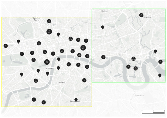
Figure 1.
Clusters (C1–C3) and micro-clusters (C4–C16) of BREEAM Outstanding-rated projects in London.

Table 1.
Various clusters, building programmes and functionalities.
This study specifically analysed the built environment, land use diversity, the connectivity of London subways, and street networks around these projects. These factors contribute to their significant influence on the environmental performance of buildings and their contribution to urban sustainability. The clusters and micro-clusters of BREEAM Outstanding-rated projects (discrete numerical data) were compared with land use diversity types (discrete numerical data), number of subway stations (discrete numerical data), betweenness centrality of edges (continuous numerical data), node degrees (discrete numerical data), and node meshedness (continuous numerical data). Geographic Information System (GIS) software (Version 3.38.3) and momepy (Version 0.7.0), a Python library designed for analysing urban morphologies, were used to conduct spatial analysis of betweenness centrality. Betweenness centrality measures how often a node lies on the shortest path between other pairs of nodes; the higher the value, the more critical that node is for the flow of information or interaction in the street network [84]. Digimap was used for the land use diversity analysis. These tools allowed for the visualisation of some urban form characteristics at neighbourhood and city scales.
The data analysis involved examining the relationship between some urban form characteristics and the achievement of BREEAM Outstanding-rated projects. Selected urban form characteristics were analysed to understand their cumulative impact on sustainable building performance.
Patterns and correlations between the urban form data and the BREEAM Outstanding-rated projects were identified using BREEAM Maps, Digimap, and momepy, as shown in the conceptual map below (Figure 2).
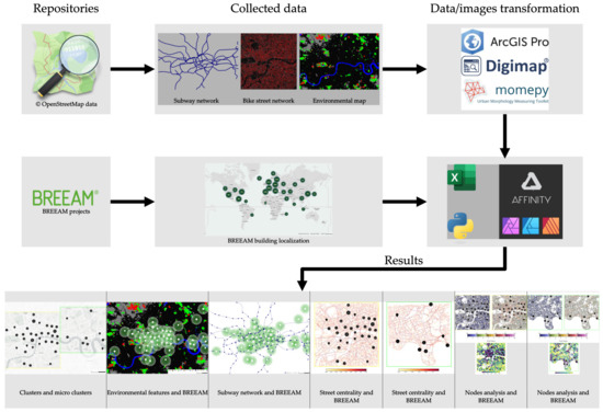
Figure 2.
Conceptual map of data sources, tools, and research results.
The analysis focused on identifying how high-density areas, mixed-use developments, and well-connected street networks contribute to the overall sustainability of BREEAM Outstanding-rated projects. Additionally, this study explored the role of green infrastructure in enhancing the environmental and social sustainability of these buildings. Methodological rigour was ensured by a validation process that compared research findings with existing literature on urban form and sustainability. The research design and methodology were structured to allow for replicability in other urban contexts, ensuring that the findings could apply to other cities with varying urban forms.
4. Research Results and Analysis
This section first presents the cluster and micro-cluster analysis, followed by land use diversity analysis, subway network analysis, street network analysis using betweenness centrality of edges and node degrees, and the relation of these factors to BREEAM Outstanding-rated projects in London.
4.1. Clusters and Micro-Clusters Analysis
Table 1 above shows various clusters (C1–C16) with respective building programmes and functionalities. Offices are the predominant building type in nearly all clusters, with the highest number in C1 and the lowest in C8. This shows an emphasis on office buildings in the sample, indicating that office projects are a key focus within these clusters. Mixed-use developments are also quite common, appearing in 11 of 16 clusters. The presence of mixed-use developments, ranging from a minimum of one (C5, C7, C10, C13, and C15) to a maximum of five (C2) within clusters, reflects a trend towards integrating multiple functionalities (e.g., residential, commercial, and institutional spaces) within projects. Higher education buildings are less common, which indicates that they are less frequent compared to offices and mixed-use developments. Residential, retail, industrial, prisons, and fire stations only appear seldomly, which signifies their localised and specialised development patterns.
Regarding cluster characteristics, C1 is the most diverse, with the widest variety of building types, including offices, mixed-use, higher education, retail, industrial, and prisons. This diversity suggests that C1 is a major hub with a broad range of functionalities, potentially indicating a highly mixed urban environment—a strategic area for varied developments. Clusters 2, 3, 5, 6, 9, 10, and 15 predominantly feature office and mixed-use buildings and are located where commercial and residential integration is emphasised, indicating a trend towards multifunctional urban spaces focused on economic activities. C6–C16 show a strong presence of office buildings with some mixed-use developments and a few higher education buildings. C4 features the highest number of retail buildings, whereas C11 is unique as it contains fire stations indicating specialised emergency services or public safety infrastructure. Clusters such as C12 and C14 are more homogeneous, consisting entirely of office buildings, which suggests areas with a more singular focus on commercial development.
4.2. Land Use Diversity Analysis and BREEAM Outstanding-Rated Projects in London
Land use diversity analysis relied on identifying various features in the city’s environment. The features include a diverse range such as broadleaved and coniferous woodlands; arable and horticulture; improved grassland; neutral grassland; calcareous grassland; acid grassland; fen, marsh, and swamp; heather; heather grassland; bog; inland rock; saltwater; freshwater; supra-littoral rock; supra-littoral sediment; littoral rock; littoral sediment; saltmarsh; urban; and suburban areas.
The spatial analysis revealed a striking pattern—all BREEAM Outstanding-rated projects in London are near one or more of these environmental features (denoted by 1 km from each cluster, micro-cluster, or project, as shown in Figure 3). No project was identified as being isolated from the natural environment, showing the critical role that access to green and blue infrastructure plays in achieving the highest sustainability standards defined by BREEAM (Figure 3). Proximity to environmental features highlights the importance of incorporating urban development with natural ecosystems. The presence of these features supports the ecological footprint of buildings and contributes to the overall sustainability, liveability, and resilience of the urban environment. Projects near broadleaved woodlands or improved grasslands benefit from enhanced air quality, biodiversity, and aesthetic value, while those close to water bodies or wetland areas gain from improved microclimate regulation and stormwater management. The analysis shows that the strategic location of these projects adjacent to significant environmental features is a key factor in their ability to meet BREEAM Outstanding rating criteria. This relationship indicates the synergy between urban form and environmental features, which enable sustainable building practices not just to be confined to architecture itself but also to create deep connections to the surrounding natural landscape.
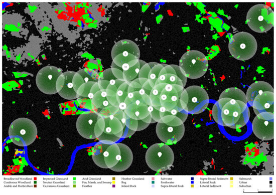
Figure 3.
Environmental features and BREEAM Outstanding-rated projects in London—the numbers denote the BREEAM Outstanding-rated certifications for projects in London.
4.3. Subway Network Analysis
The urban spatial arrangements between sustainable projects and transportation networks play an important role in urban planning and environmental sustainability. Proximity to public transportation, such as subway systems, is necessary for the success of green building initiatives. Efficient transportation links reduce the reliance on private vehicles, lowering carbon emissions and supporting increased QOUL. To analyse this connection, a detailed map was created, overlaying clusters, micro-clusters, and projects of BREEAM Outstanding ratings with a 1 km radius drawn from each project. This radius was used to assess the accessibility of these projects to London’s subway network, including both underground and overground lines (Figure 4).
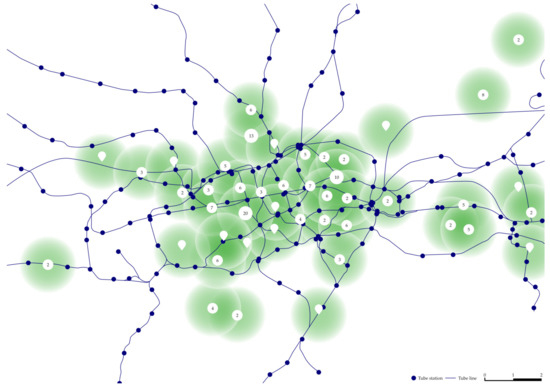
Figure 4.
Subway networks and BREEAM Outstanding-rated projects in London—the numbers denote the BREEAM Outstanding-rated certifications for projects in London.
The results indicate that all BREEAM Outstanding-rated projects in London are situated close to the subway network. Whether the subway lines are underground or overground, all identified buildings fall within a 1 km radius, demonstrating a correlation between these projects and accessible public transportation. This proximity supports the buildings’ sustainability credentials and contributes to encouraging low-carbon transportation options. This spatial relationship suggests that the strategic location of BREEAM Outstanding-rated projects is influenced by their access to underground and overground subway networks integral to achieving urban sustainability. The alignment of these projects enables easier access for building occupants, reduces transportation-related emissions, and enhances urban mobility. These factors emphasise the importance of considering transportation infrastructure in the planning and design of sustainable buildings. These findings show an understanding of how transportation networks can impact sustainable development. The proximity of these projects to London’s subway network highlights the role of public transportation in promoting the success of highly certified green buildings and in developing sustainable urban environments.
4.4. Street Network Analysis Using Betweenness Centrality of Edges
Figure 5 and Figure 6 focus on the two study areas (A and B) and represent a street network analysis using the betweenness centrality of edges overlaid with the locations of BREEAM Outstanding-rated projects in London. Betweenness centrality measures how often a street (or edge) lies on the shortest path between other streets in the network, indicating its importance to the urban grid for movement and connectivity [85]. Due to the nature of this research and the aim of improving sustainability to conduct this analysis, we decided to focus on the bike street network. The bike street network was chosen for this analysis as it represents the most sustainable and green method for urban mobility [86].
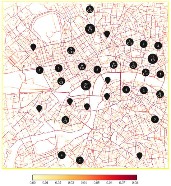
Figure 5.
Analysing street networks using betweenness centrality of Study Area A—the numbers denote the BREEAM Outstanding-rated certifications for projects in clusters and micro-clusters in London.
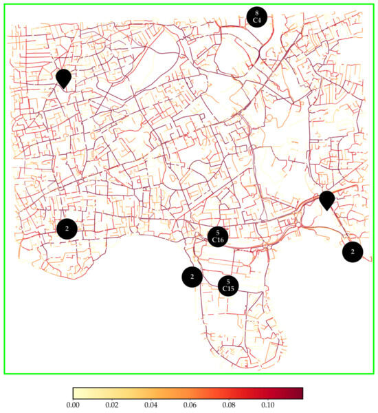
Figure 6.
Analysing street networks using betweenness centrality of Study Area B—the numbers denote the BREEAM Outstanding-rated certifications for projects and micro-clusters in London.
Key observations regarding high betweenness centrality are that the darker or thicker lines in the graphic likely indicate streets with high betweenness centrality. These streets are essential for connectivity within the city, serving as major pathways to facilitate movement across various areas. BREEAM Outstanding-rated projects are predominantly located near these high-betweenness areas, suggesting that these projects benefit from and contribute to strong urban connectivity. Similar to subway network analysis, this strategic placement enhances accessibility and may influence the sustainability of buildings by encouraging walking, cycling, and public transport (including but not limited to the subway network analysis presented in Section 4.3) over private vehicles.
The clusters (C1, C2, and C3) appear to be concentrated around areas with high concentration of streets and elevated betweenness centrality (Figure 5). This clustering pattern indicates a preference for locations to be well-integrated into the city’s overall transportation network, ensuring that these sustainable buildings are easily accessible; e.g., C1, which has the highest number of BREEAM Outstanding-rated projects, is positioned near streets that are key connectors in the city’s layout. This proximity enhances the potential for buildings to support low-carbon transportation modes, contributing to sustainability profiles.
Contrastingly, the areas corresponding to C15 and C16, as shown in Figure 6, show lighter colours on the betweenness centrality map, which lower centrality values. This suggests that these regions are less critical when it comes to urban connectivity, with fewer routes that connect important parts of the city. These clusters are at the Canary Wharf, a major financial district, and therefore consist predominantly of office buildings, reflecting the area’s role as a business hub. The presence of offices suggests these areas are still significant for business activities, although they have less network connectivity than the city centre. The lower betweenness centrality also indicates that these areas may be important for specific economic functions, and they are not as integrated into the broader urban network. These areas, particularly in East London, are less connected, resulting in fewer buildings and a lower concentration of BREEAM Outstanding-rated projects. It also signifies the challenges of achieving high sustainability certifications in regions that are not as densely connected or developed. Despite being in East London, C4 in Stratford contrasts sharply with C15 and C16 as it demonstrates higher centrality values and a similar concentration of BREEAM Outstanding-rated projects. Stratford’s role as a growing urban centre, significantly influenced by the 2012 Olympics, has improved its connectivity and made it attractive for sustainable development. Unlike C15 and C16, C4 is distinguishably different due to the most retail buildings among all clusters. This retail concentration, along with enhanced infrastructure, contributes to the higher centrality values observed in Stratford.
4.5. Street Network Analysis Using Node Degrees
Street network resilience can be investigated using graph theory representing network topology [87]. A graph is an abstract representation of pairwise relations between a set of elements in a network, which are called nodes (also vertices or points), and the connections between them are called links (also edges, arcs, or lines) [88]. Regarding Study Area A, it is prevalent that there is a dense urban grid with a high concentration of nodes throughout the central and northern parts (Figure 7 and Figure 8). Higher-degree nodes are typically representing more complex intersections with higher connectivity. They are often located in areas with dense street networks, such as city centres, whereas lower-degree nodes usually represent simpler intersections or dead-ends, typically found in residential or suburban areas. Meshedness is a way to quantify the interconnectedness of a network, with a high meshedness value indicating a densely interconnected network and a low meshedness value indicating a more sparse or hierarchical network. The node degree maps in Figure 7 illustrate the connectivity of clusters and micro-clusters. The graphic on the right highlights areas with high connectivity, such as clusters C8, C10, and C11, characterised by a dense network of well-connected nodes. In contrast, the graphic on the left depicts clusters with lower connectivity, such as C3 and C12, which are represented by sparsely connected intersections. This distinction shows the spatial variation in network density across the study area. The presence of numerous BREEAM Outstanding-rated projects in these clusters highlights their strategic location, showing the importance of street connectivity.
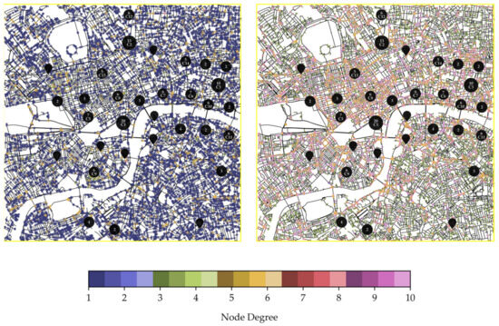
Figure 7.
Analysing street networks using node degrees of Study Area A—the numbers denote the BREEAM Outstanding-rated certifications for projects in clusters and micro-clusters in London.
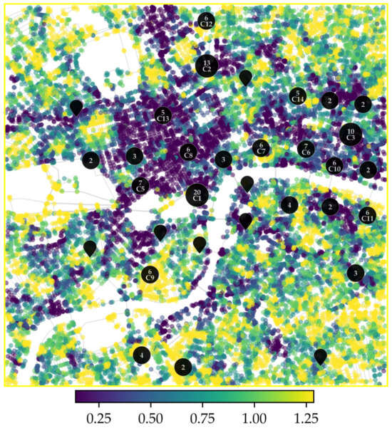
Figure 8.
Analysing street meshedness using nodes of Study Area A—the numbers denote the BREEAM Outstanding-rated certifications for projects in clusters and micro-clusters in London.
Contrastingly, Study Area B shows a generally less dense and more spread-out street network (Figure 9 and Figure 10). The mapped nodes reflect lower connectivity levels. This lower node degree density is particularly evident in the southern and eastern sections of Study Area B. However, C16, near Canary Wharf, stand out with slightly better connectivity, particularly around office buildings. It suggests that while the overall area may be less connected than Study Area A, C16 is supported by higher connectivity for their economic activities. Another exception is C4 in Stratford, revealing a high concentration of retail projects. This area shows moderate node degree values, and the cluster’s position in a moderately connected zone highlights Stratford’s strategic importance in East London’s spatial arrangement.
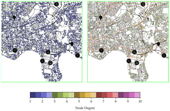
Figure 9.
Analysing street networks using node degree of Study Area B—the numbers denote the BREEAM Outstanding-rated certifications for projects in clusters and micro-clusters in London.
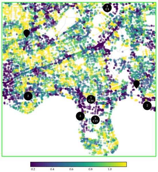
Figure 10.
Analysing street meshedness using nodes of Study Area B—the numbers denote the BREEAM Outstanding-rated certifications for projects in clusters and micro-clusters in London.
Balanced connectivity with a mix of nodes of varying degrees helps maintain an optimal flow, ensuring that while some hubs manage large volumes, smaller intersections support localised movement. Balanced connectivity also supports various modes of transport and distributes the traffic flow. A mix of high- and low-degree nodes influences diverse public spaces that encourage interaction, facilitating vibrant communities and social cohesion. Moreover, the distribution of node degrees can help incorporate green spaces in urban planning, enabling biodiversity. The street network analysis of Study Areas A and B shows the varying degrees of urban connectivity and their influence on the distribution of BREEAM Outstanding-rated projects in London. Densely connected areas tend to accommodate a higher concentration of these projects, and areas of strategic significance due to infrastructure developments like Canary Wharf and Stratford also support sustainable planning and design of buildings.
5. Discussion
The results were affected by the structured analysis of the concentration and distribution of BREEAM Outstanding-rated projects, as by dividing the study area into clusters and micro-clusters, the investigation detected spatial concentrations where the highest number of BREEAM Outstanding-rated projects occurred. These clusters, particularly C1, are located in areas with high betweenness centrality, making them integral to urban movement and suggesting that these projects benefit from street and subway network connectivity. The structured approach also enabled the analysis of the relationship between these projects and their proximity to environmental features to further clarify land use and ecological synergies. By structuring the study area through clusters and micro-clusters, the analysis reveals clear patterns of how urban spatial arrangement factors such as urban connectivity, access to environmental features, and transportation networks are directly linked to the concentration and distribution of BREEAM Outstanding-rated projects. Each analysed factor related to urban spatial arrangements and BREEAM Outstanding-rated projects explored various ideas to advance the correlation of urban form’s contribution to sustainable buildings (Table 2).
Table 2.
Synoptic view of urban spatial arrangement factors and BREEAM Outstanding-rated projects in London, UK.
Cluster analysis of Study Areas A and B showed significant clusters of BREEAM Outstanding-rated projects, with a concentration in Central London, such as C1, C2, and C3, which have 20, 13, and 10 projects, respectively. Overall, office buildings are the most common building function across the clusters. While mixed-use developments are widespread and support various functionalities, there is a limited presence of higher education institutions, suggesting that this is a less common focus. While high diversity is observed in C1 with varied development patterns, supporting a highly mixed urban environment showing six different building functionalities, homogeneity is observed in clusters C12 and C14, consisting entirely of office buildings. Specialised clusters were seen in C4 (retail projects) and C11 (fire stations).
Land use diversity analysis identified that all BREEAM Outstanding-rated projects in London are within 1 km of one or more significant environmental features. Proximity to these features has an impact on achieving high sustainability standards. The strategic planning of these projects near environmental features indicates their ability to achieve high sustainability ratings and uncovers the spatial relationship between urban form and natural landscapes to enable sustainable building practices and extend beyond architecture to develop deep connections with surrounding natural environments.
Similarly, subway network analysis revealed a similar trend of all projects being located within a 1 km radius of the subway network, including underground and overground lines. This close access to efficient transportation links is necessary for the success of green building initiatives as they reduce reliance on private vehicles to reduce carbon emissions and increase QOUL by promoting urban mobility. This factor discovered the importance of considering transportation infrastructure in planning and designing future BREEAM Outstanding-rated projects for successfully developing sustainable urban environments.
Street network analysis using betweenness centrality of edges primarily evidenced six clusters showing promising findings. C1, C2, and C3 in a high concentration of streets, particularly C1 near key connecting streets, supported numerous BREEAM Outstanding-rated projects. Clusters located in Canary Wharf displayed lower betweenness centrality, although it is a financial district with many office buildings. In the future, lower betweenness centrality will cause a challenge to Architecture, Engineering, and Construction (AEC) teams when trying to achieve high sustainability certifications as fewer BREEAM Outstanding-rated projects are seen in Study Area B. An unexpected outcome of the street network analysis using betweenness centrality of edges was C4 in Stratford, East London, which recognised the impact of global events on the urban form of cities, e.g., the 2012 Olympics. The cluster showed higher centrality values, better connectivity, and concentration of retail projects than other clusters in Study Area B.
Street network analysis using node degrees presented trends associated with a dense urban grid and high connectivity in Study Area A and lower connectivity and spread-out network in Study Area B. Clusters C8, C10, and C11 located in a dense network benefited from strong interconnectivity facilitating movement and access for both pedestrians and vehicles. However, despite having comparatively lower connectivity, C16 stands out due to better connectivity levels around office buildings; in contrast, C4 emerged as an exception, with a higher concentration of retail projects and moderate node degree values. Summarily, it is evident that balanced connectivity with nodes of varying degrees helps optimal flow, while smaller intersections support localised movement. Balanced connectivity also support various transportation modes and enables traffic flow distribution.
The analysis of the examined factors—land use diversity, subway network analysis, and street network analysis—is summarised below using an area of 1 km around the clusters (Table 3). The table provides a detailed quantification of these factors in relation to the identified clusters, offering insights into their interconnections and contributions to the observed patterns.
Table 3.
Quantified examined factors and BREEAM Outstanding-rated projects.
The Cluster Column and Line Diagrams (Figure 11) visually explore the relationship between the number of BREEAM Outstanding-rated projects, the land use diversity types and subway stations across different clusters. In the diagram, the clustered columns represent the number of projects in each cluster, while the line graphs illustrate the number of land use types and the number of subway stations in proximity to each cluster.
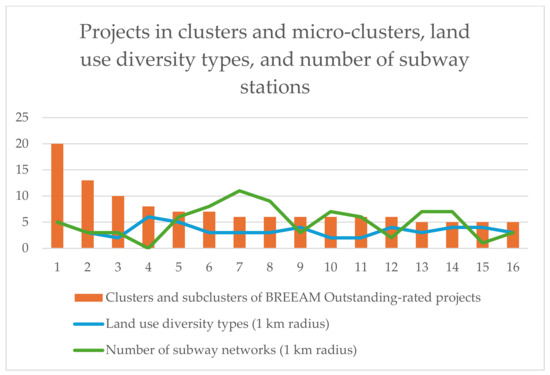
Figure 11.
Relationship between clusters and micro-clusters, land use diversity types, and number of subway stations across clusters.
Additionally, the clusters and micro-clusters of BREEAM Outstanding-rated projects were compared based on edge centrality, node degrees, and street meshedness within the identified Study Areas A and B, considering a 1 km2 area around the clusters (Table 4).
Table 4.
Comparative analysis of clusters, micro-clusters, and Study Areas A and B and average centrality of edges, node degrees, and street meshedness.
These research results are consistent with previous studies related to urban spatial arrangements and sustainable buildings, urban form and environmental features, transport infrastructure, street network connectivity, and the impact of global events on urban form. For instance, Steemers [93] mentioned that higher urban density and strategic spatial arrangements contribute to reduced energy consumption, enhancing the sustainability of urban environments. This is consistent with another argument [94] that compact urban forms and mixed-use developments are integral to sustainable urban planning. These results corroborate the hypothesis that the spatial configuration of urban areas plays a crucial role in supporting sustainable building practices. Newman et al. [95] observed that integrating natural elements within urban planning significantly contributes to the resilience and sustainability of cities. This finding supports previous research, which has consistently shown that urban areas located near natural landscapes tend to exhibit better environmental performance of buildings. These observations substantiate that including environmental features in urban planning could be a critical determinant of sustainability outcomes. Cervero [96], for example, found that the availability of efficient public transportation systems correlates strongly with reduced car dependency and lower carbon emissions. This is confirmed by Banister [97], who identified the sustainable mobility paradigm as essential for promoting sustainable urban growth. Together, these studies indicate that well-integrated transportation infrastructure is pivotal in reducing the environmental footprint of the built environment. Hillier [98] found that urban areas with highly connected street networks tend to facilitate pedestrian movement, which is conducive to sustainability. Similarly, Sevtsuk [99] provided evidence that areas with well-connected street grids are associated with greater economic vitality and sustainability. These findings imply that higher levels of street connectivity are positively linked with the achievement of sustainable urban forms. Essex and Chalkley [100] identified that mega-sporting events often lead to significant urban regeneration and infrastructure development. This observation is in line with other findings [101], which indicate that such events can be strategically leveraged to revitalise cities and improve their long-term sustainability. These findings suggest that global events may act as catalysts for sustainable urban development, reshaping urban environments in a manner that supports sustainable buildings.
The planning and design of future BREEAM Outstanding-rated projects developed by studying urban spatial arrangements will need transdisciplinary collaboration [102,103,104,105,106] through interdisciplinary teams [107,108,109,110], including (but not limited to) clients, architects, urban planners, civil and structural engineers, mechanical, electrical and plumbing engineers, environmental consultants, sustainability consultants, energy modellers, landscape architects, construction managers, acoustic consultants, Building Information Modelling (BIM) specialists, cost consultants, facilities managers, health and safety experts, and IT and smart building specialists to work in tandem with each other.
6. Conclusions
This paper aimed to investigate the impact of urban spatial arrangements and BREEAM Outstanding-rated projects in London, UK. Cluster analysis, land use diversity analysis using Digimap, subway network analysis, and urban morphometric analysis using momepy for street network analysis through betweenness centrality of edges and nodes enabled the discovery of the relationship between urban morphology and sustainable building practices contributing to urban sustainability. The land use diversity analysis revealed that all BREEAM Outstanding-rated projects, clusters, and micro-clusters (C1–C16) in London are situated within 1 km of significant environmental features, emphasising the critical role of proximity to natural landscapes in attaining high sustainability standards. The subway network analysis showed that all projects across clusters are located within a 1 km radius of subway networks, including underground and overground lines. This accessibility to efficient transportation infrastructure is crucial for reducing reliance on private vehicles, thereby lowering carbon emissions and enhancing the quality of urban life (QOUL). The street network analysis revealed distinct connectivity trends, with Study Area A characterised by a dense urban grid and high connectivity, while Study Area B exhibited a more spread-out network. Clusters C1, C2, C7, and C13, located in highly connected areas, benefited from strong interconnectivity, enhancing movement for pedestrians and vehicles. Conversely, despite lower overall connectivity, clusters C15 and C16 stood out due to improved connectivity around office buildings, while C4 showed moderate centrality values with a focus on retail projects. Overall, the findings indicate that while densely connected areas tend to have more BREEAM Outstanding-rated projects, financial districts and strategically developed infrastructure also play a critical role in enabling the planning and design of highly certified sustainable buildings.
This research has numerous implications for policy: (1) urban planning and zoning (policymakers prioritising urban connectivity and integrating green spaces into city planning for dense well-connected urban grids and easy access to public transportation), (2) sustainability standards (policy incentivisation by including green infrastructure into building codes and urban planning guidelines), (3) infrastructure development (investing in under-connected areas to enhance urban sustainability to attract more sustainable projects leading to a more balanced urban growth); and industry: (1) site selection and design (choosing locations with high connectivity to transportation networks and green spaces to achieve higher sustainability ratings), (2) mixed-use development (AEC industry should continue to embrace mixed-use designs integrating various building functions), and (3) strategic investment (real estate investors and developers should consider urban connectivity and environmental integration on property values and sustainability credentials). Potential further research towards a sustainable urban future may entail (1) exploring the urban spatial arrangements of neighbourhoods with specific functions inside London, UK, e.g., a comparative analysis of C4 (retail projects) and C11 (fire stations) to identify favourable urban morphological conditions for specific building functions; (2) a comparative analysis of urban spatial arrangements of other cities with BREEAM Outstanding-rated projects in the UK, e.g., Bristol and Leeds; (3) exploring the impact of urban spatial arrangements of other cities with a high concentration of BREEAM Outstanding-rated projects, e.g., Paris, France; Barcelona, Spain; Madrid, Spain; Stockholm, Sweden; Warsaw, Poland; Kraków, Poland; and Bucharest, Romania; and (4) analysing highly certified buildings by other environmental assessment methods such as LEED Platinum certified buildings or Green Star Six Star-rated buildings.
Author Contributions
This paper has been written by A.N.B. in collaboration with C.R. The co-authors contributed to the paper as follows: Conceptualization, methodology, investigation, validation, A.N.B. and C.R.; formal analysis, project administration, and writing—original draft preparation, A.N.B.; software, visualization, and writing—review and editing, C.R. All authors have read and agreed to the published version of the manuscript.
Funding
This research received no external funding.
Data Availability Statement
The data presented in this study are available on the official website of BREEAM: “https://tools.breeam.com/projects/explore/map.jsp (accessed on 20 August 2024)”, and the data associated with Urban Morphometric analysis can be found on OpenStreetMap: “https://www.openstreetmap.org/#map=5/54.91/-3.43 (accessed on 20 August 2024)”. All these data are present in the public domain.
Conflicts of Interest
The authors declare no conflicts of interest.
References
- Rega, C.; Bonifazi, A. The rise of resilience in spatial planning: A journey through disciplinary boundaries and contested practices. Sustainability 2020, 12, 7277. [Google Scholar] [CrossRef]
- Jo, S. Spatial configuration and built form. J. Urban Des. 1998, 3, 285–302. [Google Scholar] [CrossRef]
- Kumar, P. Climate change and cities: Challenges ahead. Front. Sustain. Cities 2021, 3, 645613. [Google Scholar] [CrossRef]
- Maxwell, J.W.; Reuveny, R. Resource Scarcity and Conflict in Developing Countries. J. Peace Res. 2000, 37, 301–322. [Google Scholar] [CrossRef]
- Glaeser, E.L.; Resseger, M.; Tobio, K. Inequality in cities. J. Reg. Sci. 2009, 49, 617–646. [Google Scholar] [CrossRef]
- Awadh, O. Sustainability and green building rating systems: LEED, BREEAM, GSAS and Estidama critical analysis. J. Build. Eng. 2017, 11, 25–29. [Google Scholar] [CrossRef]
- Schweber, L. The effect of BREEAM on clients and construction professionals. Build. Res. Inf. 2013, 41, 129–145. [Google Scholar] [CrossRef]
- Campbell, E. BREEAM Ratings. Available online: https://www.tallyworkspace.com/articles/breeam-ratings# (accessed on 10 August 2024).
- Rebelatto, B.G.; Salvia, A.L.; Brandli, L.L.; Leal Filho, W. Examining Energy Efficiency Practices in Office Buildings through the Lens of LEED, BREEAM, and DGNB Certifications. Sustainability 2024, 16, 4345. [Google Scholar] [CrossRef]
- Jorge-Ortiz, A.; Braulio-Gonzalo, M.; Bovea, M.D. Exploring how waste management is being approached in green building rating systems: A case study. Waste Manag. Res. 2023, 41, 1121–1133. [Google Scholar] [CrossRef]
- Serrano-Baena, M.M.; Hidalgo Fernández, R.E.; Carranza-Cañadas, P.; Triviño-Tarradas, P. How the Implementation of BREEAM in hotels could help to achieve the SDGs. Appl. Sci. 2021, 11, 11131. [Google Scholar] [CrossRef]
- Udawatta, N.; Zuo, J.; Chiveralls, K.; Zillante, G. From green buildings to living buildings? Rating schemes and waste management practices in Australian educational buildings. Eng. Constr. Archit. Manag. 2021, 28, 1278–1294. [Google Scholar] [CrossRef]
- Wu, Z.; Wu, Z.; Li, H.; Zhang, X.; Jiang, M. Developing a strategic framework for adopting water-saving measures in construction projects. Environ. Geochem. Health 2020, 42, 955–968. [Google Scholar] [CrossRef] [PubMed]
- Futcher, J.; Mills, G.; Emmanuel, R.; Korolija, I. Creating sustainable cities one building at a time: Towards an integrated urban design framework. Cities 2017, 66, 63–71. [Google Scholar] [CrossRef]
- Marat-Mendes, T. Sustainability and the study of urban form T. Marat-Mendes. Urban Morphol. 2013, 17, 123–124. [Google Scholar] [CrossRef]
- Arundel, R.; Ronald, R. The role of urban form in sustainability of community: The case of Amsterdam. Environ. Plan. B Urban Anal. City Sci. 2017, 44, 33–53. [Google Scholar] [CrossRef]
- van Diepen, A.; Voogd, H. Sustainability and planning: Does urban form matter? Int. J. Sustain. Dev. 2001, 4, 59–74. [Google Scholar] [CrossRef]
- Ko, Y. Urban form and residential energy use: A review of design principles and research findings. J. Plan. Lit. 2013, 28, 327–351. [Google Scholar] [CrossRef]
- Dave, S. High urban densities in developing countries: A sustainable solution? Built Environ. 2010, 36, 9–27. [Google Scholar] [CrossRef]
- Monteiro, J.; Sousa, N.; Coutinho-Rodrigues, J.; Natividade-Jesus, E. Challenges ahead for sustainable cities: An urban form and transport system review. Energies 2024, 17, 409. [Google Scholar] [CrossRef]
- Wang, Y.; Bakker, F.; De Groot, R.; Wörtche, H. Effect of ecosystem services provided by urban green infrastructure on indoor environment: A literature review. Build. Environ. 2014, 77, 88–100. [Google Scholar] [CrossRef]
- Brown, B.B.; Yamada, I.; Smith, K.R.; Zick, C.D.; Kowaleski-Jones, L.; Fan, J.X. Mixed land use and walkability: Variations in land use measures and relationships with BMI, overweight, and obesity. Health Place 2009, 15, 1130–1141. [Google Scholar] [CrossRef] [PubMed]
- Sohn, D.W.; Moudon, A.V.; Lee, J. The economic value of walkable neighborhoods. Urban Des. Int. 2012, 17, 115–128. [Google Scholar] [CrossRef]
- Leyden, K.M. Social capital and the built environment: The importance of walkable neighborhoods. Am. J. Public Health 2003, 93, 1546–1551. [Google Scholar] [CrossRef] [PubMed]
- Bibri, S.E. Compact urbanism and the synergic potential of its integration with data-driven smart urbanism: An extensive interdisciplinary literature review. Land Use Policy 2020, 97, 104703. [Google Scholar] [CrossRef]
- Angel, S.; Franco, S.A.; Liu, Y.; Blei, A.M. The shape compactness of urban footprints. Prog. Plan. 2020, 139, 100429. [Google Scholar] [CrossRef]
- Štrbac, S.; Kašanin-Grubin, M.; Pezo, L.; Stojić, N.; Lončar, B.; Ćurčić, L.; Pucarević, M. Green infrastructure designed through nature-based solutions for sustainable urban development. Int. J. Environ. Res. Public Health 2023, 20, 1102. [Google Scholar] [CrossRef]
- He, B.-J. Green building: A comprehensive solution to urban heat. Energy Build. 2022, 271, 112306. [Google Scholar] [CrossRef]
- Al-Kodmany, K. Sustainability and the 21st century vertical city: A review of design approaches of tall buildings. Buildings 2018, 8, 102. [Google Scholar] [CrossRef]
- Pozoukidou, G.; Chatziyiannaki, Z. 15-Minute City: Decomposing the new urban planning eutopia. Sustainability 2021, 13, 928. [Google Scholar] [CrossRef]
- Allam, Z.; Bibri, S.E.; Chabaud, D.; Moreno, C. The ‘15-Minute City’concept can shape a net-zero urban future. Humanit. Soc. Sci. Commun. 2022, 9, 1–5. [Google Scholar] [CrossRef]
- Allam, Z.; Bibri, S.E.; Chabaud, D.; Moreno, C. The theoretical, practical, and technological foundations of the 15-minute city model: Proximity and its environmental, social and economic benefits for sustainability. Energies 2022, 15, 6042. [Google Scholar] [CrossRef]
- AlWaer, H.; Cooper, I. Understanding the 20-Minute Neighbourhood: Making Opportunities for People to Live Well Locally; University of Dundee: Dundee, UK, 2024. [Google Scholar]
- Wey, W.-M.; Zhang, H.; Chang, Y.-J. Alternative transit-oriented development evaluation in sustainable built environment planning. Habitat Int. 2016, 55, 109–123. [Google Scholar] [CrossRef]
- Motieyan, H.; Mesgari, M.S. Towards sustainable urban planning through transit-oriented development (A case study: Tehran). ISPRS Int. J. Geo-Inf. 2017, 6, 402. [Google Scholar] [CrossRef]
- Lee, J.S.; Kim, J.T.; Lee, M.G. Mitigation of urban heat island effect and greenroofs. Indoor Built Environ. 2014, 23, 62–69. [Google Scholar] [CrossRef]
- Park, J.; Shin, Y.; Kim, S.; Lee, S.-W.; An, K. Efficient plant types and coverage rates for optimal green roof to reduce urban heat island effect. Sustainability 2022, 14, 2146. [Google Scholar] [CrossRef]
- Robinson, J.; Attuyer, K. Extracting value, London style: Revisiting the role of the state in urban development. Int. J. Urban Reg. Res. 2021, 45, 303–331. [Google Scholar] [CrossRef]
- Evans, G. Designing legacy and the legacy of design: London 2012 and the Regeneration Games. ARQ Archit. Res. Q. 2014, 18, 353–366. [Google Scholar] [CrossRef]
- Kaika, M. Architecture and crisis: Re-inventing the icon, re-imag (in) ing London and re-branding the City. Trans. Inst. Br. Geogr. 2010, 35, 453–474. [Google Scholar] [CrossRef]
- Venerandi, A.; Zanella, M.; Romice, O.; Dibble, J.; Porta, S. Form and urban change–An urban morphometric study of five gentrified neighbourhoods in London. Environ. Plan. B Urban Anal. City Sci. 2017, 44, 1056–1076. [Google Scholar] [CrossRef]
- Foord, J. Mixed-use trade-offs: How to live and work in a compact city neighbourhood. Built Environ. 2010, 36, 47–62. [Google Scholar] [CrossRef]
- Ferm, J.; Panayotopoulos-Tsiros, D.; Griffiths, S. Planning urban manufacturing, industrial building typologies, and built environments: Lessons from inner London. Urban Plan. 2021, 6, 350–367. [Google Scholar] [CrossRef]
- Heblich, S.; Redding, S.J.; Sturm, D.M. The making of the modern metropolis: Evidence from London. Q. J. Econ. 2020, 135, 2059–2133. [Google Scholar] [CrossRef]
- Fleischmann, M.; Romice, O.; Porta, S. Measuring urban form: Overcoming terminological inconsistencies for a quantitative and comprehensive morphologic analysis of cities. Environ. Plan. B Urban Anal. City Sci. 2021, 48, 2133–2150. [Google Scholar] [CrossRef]
- Wang, J.; Fleischmann, M.; Venerandi, A.; Romice, O.; Kuffer, M.; Porta, S. EO+ Morphometrics: Understanding cities through urban morphology at large scale. Landsc. Urban Plan. 2023, 233, 104691. [Google Scholar] [CrossRef]
- Pomponi, F.; Saint, R.; Arehart, J.H.; Gharavi, N.; D’Amico, B. Decoupling density from tallness in analysing the life cycle greenhouse gas emissions of cities. NPJ Urban Sustain. 2021, 1, 33. [Google Scholar] [CrossRef]
- Tobin, M.; Hajna, S.; Orychock, K.; Ross, N.; DeVries, M.; Villeneuve, P.J.; Frank, L.D.; McCormack, G.R.; Wasfi, R.; Steinmetz-Wood, M. Rethinking walkability and developing a conceptual definition of active living environments to guide research and practice. BMC Public Health 2022, 22, 450. [Google Scholar] [CrossRef]
- Baobeid, A.; Koç, M.; Al-Ghamdi, S.G. Walkability and its relationships with health, sustainability, and livability: Elements of physical environment and evaluation frameworks. Front. Built Environ. 2021, 7, 721218. [Google Scholar] [CrossRef]
- Berardi, U. Sustainability assessments of buildings, communities, and cities. In Assessing and Measuring Environmental Impact and Sustainability; Elsevier: Amsterdam, The Netherlands, 2015; pp. 497–545. [Google Scholar]
- Sung, H.; Lee, S.; Cheon, S.; Yoon, J. Pedestrian safety in compact and mixed-use urban environments: Evaluation of 5D measures on pedestrian crashes. Sustainability 2022, 14, 646. [Google Scholar] [CrossRef]
- Tsihrintzis, V.A.; Hamid, R. Modeling and management of urban stormwater runoff quality: A review. Water Resour. Manag. 1997, 11, 136–164. [Google Scholar] [CrossRef]
- Wallington, T.J.; Anderson, J.E.; Dolan, R.H.; Winkler, S.L. Vehicle emissions and urban air quality: 60 years of progress. Atmosphere 2022, 13, 650. [Google Scholar] [CrossRef]
- Ujang, N.; Kozlowski, M.; Maulan, S. Linking place attachment and social interaction: Towards meaningful public places. J. Place Manag. Dev. 2018, 11, 115–129. [Google Scholar] [CrossRef]
- Badach, J.; Szczepański, J.; Bonenberg, W.; Gębicki, J.; Nyka, L. Developing the urban Blue-Green Infrastructure as a tool for urban air quality management. Sustainability 2022, 14, 9688. [Google Scholar] [CrossRef]
- Elliott, H.; Eon, C.; Breadsell, J.K. Improving City vitality through urban heat reduction with green infrastructure and design solutions: A systematic literature review. Buildings 2020, 10, 219. [Google Scholar] [CrossRef]
- Balany, F.; Muttil, N.; Muthukumaran, S.; Wong, M.S.; Ng, A.W. Studying the effect of blue-green infrastructure on microclimate and human thermal comfort in melbourne’s central business district. Sustainability 2022, 14, 9057. [Google Scholar] [CrossRef]
- BREEAM. BREEAM New Construction. Available online: https://breeam.com/standards/new-construction (accessed on 13 September 2024).
- BREEAM. London School of Economics Gets BREEAM Rating of Outstanding. Available online: https://breeam.com/case-studies?q=land+use&categories=463241&_its=eF5Vj0sOgjAURffSsQj90ZYdOHANpJ-HNKnUlCoDI2v3qSOn95zc3PskjxjIQLQT0k_ONb5TrhHcssZa2TfcWEe58V5OnBzIWm0F1EuqO1VMCaGp7Pdkl7CzUSmt-LhCHvnUsaCMkIH3jkntvTHG9ZpyCUBph1W21hLdvca8kOFJbneX4jpDwfZLzpcE6IR8tREx2bbt-EuPPl-RFJiglK8913pbh7b9d1qU_GyXBdIJD36n4f7izzl8HuBK8sIgVvhwQbkQrzdBJFO1 (accessed on 27 September 2024).
- Leyzerova, A.; Sharovarova, E.; Alekhin, V. Sustainable strategies of urban planning. Procedia Eng. 2016, 150, 2055–2061. [Google Scholar] [CrossRef]
- Borowczyk, J. Sustainable urban development: Spatial analyses as novel tools for planning a universally designed city. Sustainability 2018, 10, 1407. [Google Scholar] [CrossRef]
- Mao, T.; Li, Q. The Impact of Sustainable Development and Spatial Rationality Planning of Urban Buildings Under the Guidance of Local Government Policies: Environmental Policy and Green Building Design Principles. Lex Localis-J. Local Self-Gov. 2024, 22, 197–216. [Google Scholar] [CrossRef]
- De Castro Mazarro, A.; George Kaliaden, R.; Wende, W.; Egermann, M. Beyond urban ecomodernism: How can degrowth-aligned spatial practices enhance urban sustainability transformations. Urban Stud. 2023, 60, 1304–1315. [Google Scholar] [CrossRef]
- Vetter, A. The matrix of convivial technology–assessing technologies for degrowth. J. Clean. Prod. 2018, 197, 1778–1786. [Google Scholar] [CrossRef]
- Shakibamanesh, A.; Karimian, B. Utilizing Space Syntax Techniques to Understand the Relationship Between Spatial Configuration and Walkability in Urban Neighborhoods (Case Study: Valiasr Neighborhood, Tehran). Urban Plan. Constr. 2024, 2, 40–54. [Google Scholar] [CrossRef]
- van Bergen, J. ShoreScape: A landscape approach to the natural adaptation of urbanized sandy shores. A+BE Archit. Built Environ. 2023, 13, 1–356. [Google Scholar]
- Santos, J.R. Tokyo, Japan–urbanistic hybridity in a networked metropolis. J. Place Manag. Dev. 2022, 15, 70–89. [Google Scholar] [CrossRef]
- Bonilla-Duarte, S.; Gómez-Valenzuela, V.; Vargas-de la Mora, A.-L.; García-García, A. Urban forest sustainability in residential areas in the city of Santo Domingo. Forests 2021, 12, 884. [Google Scholar] [CrossRef]
- Carmona, M. Sustainable urban design: Principles to practice. Int. J. Sustain. Dev. 2009, 12, 48–77. [Google Scholar] [CrossRef]
- Liu, J.; Tanaka, T.; Tan, L. The impact of building spatial layouts on microclimate in residential districts: A case study in Kumamoto. J. Civ. Eng. Urban Plan. 2023, 5, 46–53. [Google Scholar]
- Adeel, A.; Notteboom, B.; Yasar, A. Insights into the Impact of Mega Transport Infrastructure Projects on the Transformation of the Urban Fabric of Lahore; KU Leuven: Leuven, Belgium, 2022. [Google Scholar]
- McCormick, K.; Anderberg, S.; Coenen, L.; Neij, L. Advancing sustainable urban transformation. J. Clean. Prod. 2013, 50, 1–11. [Google Scholar] [CrossRef]
- Cohen, M. A systematic review of urban sustainability assessment literature. Sustainability 2017, 9, 2048. [Google Scholar] [CrossRef]
- Lafortezza, R.; Davies, C.; Sanesi, G.; Konijnendijk, C.C. Green Infrastructure as a tool to support spatial planning in European urban regions. IForest-Biogeosci. For. 2013, 6, 102. [Google Scholar] [CrossRef]
- Sharifi, A.; Murayama, A. Neighborhood sustainability assessment in action: Cross-evaluation of three assessment systems and their cases from the US, the UK, and Japan. Build. Environ. 2014, 72, 243–258. [Google Scholar] [CrossRef]
- Fleischmann, M.; Feliciotti, A.; Romice, O.; Porta, S. Methodological foundation of a numerical taxonomy of urban form. Environ. Plan. B Urban Anal. City Sci. 2022, 49, 1283–1299. [Google Scholar] [CrossRef]
- Fleischmann, M.; Feliciotti, A.; Romice, O.; Porta, S. Morphological tessellation as a way of partitioning space: Improving consistency in urban morphology at the plot scale. Comput. Environ. Urban Syst. 2020, 80, 101441. [Google Scholar] [CrossRef]
- Fleischmann, M. Momepy: Urban morphology measuring toolkit. J. Open Source Softw. 2019, 4, 1807. [Google Scholar] [CrossRef]
- Gonçalves, P.; Vierikko, K.; Elands, B.; Haase, D.; Luz, A.C.; Santos-Reis, M. Biocultural diversity in an urban context: An indicator-based decision support tool to guide the planning and management of green infrastructure. Environ. Sustain. Indic. 2021, 11, 100131. [Google Scholar] [CrossRef]
- Pupphachai, U.; Zuidema, C. Sustainability indicators: A tool to generate learning and adaptation in sustainable urban development. Ecol. Indic. 2017, 72, 784–793. [Google Scholar] [CrossRef]
- Siqueira-Gay, J.; Sánchez, L.E. Mainstreaming environmental issues into housing plans: The approach of Strategic Environmental Assessment. Environ. Impact Assess. Rev. 2019, 77, 145–153. [Google Scholar] [CrossRef]
- Nyerges, T.L.; Jankowski, P. Regional and Urban GIS: A Decision Support Approach; Guilford Press: New York, NY, USA, 2009. [Google Scholar]
- BREEAM. Explore BREEAM. Available online: https://tools.breeam.com/projects/explore/map.jsp (accessed on 13 August 2024).
- Porta, S.; Crucitti, P.; Latora, V. The network analysis of urban streets: A primal approach. Environ. Plan. B Plan. Des. 2006, 33, 705–725. [Google Scholar] [CrossRef]
- Crucitti, P.; Latora, V.; Porta, S. Centrality in networks of urban streets. Chaos Interdiscip. J. Nonlinear Sci. 2006, 16, 015113. [Google Scholar] [CrossRef]
- Oskarbski, J.; Birr, K.; Żarski, K. Bicycle traffic model for sustainable urban mobility planning. Energies 2021, 14, 5970. [Google Scholar] [CrossRef]
- Jiang, B.; Claramunt, C. A structural approach to the model generalization of an urban street network. GeoInformatica 2004, 8, 157–171. [Google Scholar] [CrossRef]
- Boeing, G. OSMnx: New methods for acquiring, constructing, analyzing, and visualizing complex street networks. Comput. Environ. Urban Syst. 2017, 65, 126–139. [Google Scholar] [CrossRef]
- Five, C. Sustainability in the Spotlight: 280 Bishopsgate. Available online: https://corefive.co.uk/sustainability-in-the-spotlight-280-bishopsgate/ (accessed on 27 September 2024).
- SRM. Available online: https://www.srm.com/news-and-comment/100-liverpool-street-certified-breeam-outstanding/ (accessed on 27 September 2024).
- Soulti, E. White Collar Factory. Available online: https://www.designingbuildings.co.uk/wiki/White_Collar_Factory (accessed on 27 September 2024).
- Bloomberg. Bloomberg BREEAM Certificates; Bloomberg: New York, NY, USA, 2017. [Google Scholar]
- Steemers, K. Energy and the city: Density, buildings and transport. Energy Build. 2003, 35, 3–14. [Google Scholar] [CrossRef]
- Jabareen, Y.R. Sustainable urban forms: Their typologies, models, and concepts. J. Plan. Educ. Res. 2006, 26, 38–52. [Google Scholar] [CrossRef]
- Newman, P.; Beatley, T.; Boyer, H. Resilient cities: Responsing to peak oil and climate change. Aust. Plan. 2009, 46, 59. [Google Scholar] [CrossRef]
- Cervero, R. Built environments and mode choice: Toward a normative framework. Transp. Res. Part D Transp. Environ. 2002, 7, 265–284. [Google Scholar] [CrossRef]
- Banister, D. The sustainable mobility paradigm. Transp. Policy 2008, 15, 73–80. [Google Scholar] [CrossRef]
- Hillier, B. Space Is the Machine: A Configurational Theory of Architecture; Space Syntax: London, UK, 2007. [Google Scholar]
- Sevtsuk, A. Path and Place: A Study of Urban Geometry and Retail Activity in Cambridge and Somerville; Massachusetts Institute of Technology: Cambridge, MA, USA, 2010. [Google Scholar]
- Essex, S.; Chalkley, B. Mega-sporting events in urban and regional policy: A history of the Winter Olympics. Plan. Perspect. 2004, 19, 201–204. [Google Scholar] [CrossRef]
- Smith, A. Events and Urban Regeneration: The Strategic Use of Events to Revitalise Cities; Routledge: London, UK, 2012. [Google Scholar]
- Horcea-Milcu, A.-I.; Leventon, J.; Lang, D.J. Making transdisciplinarity happen: Phase 0, or before the beginning. Environ. Sci. Policy 2022, 136, 187–197. [Google Scholar] [CrossRef]
- Lorenz, S. Transdisciplinary sustainability research. Procedural perspectives and professional cooperation. Curr. Res. Environ. Sustain. 2022, 4, 100182. [Google Scholar] [CrossRef]
- Kreß-Ludwig, M.; Marg, O.; Schneider, R.; Lux, A. Lessons from transdisciplinary urban research to promote sustainability transformation in real-world labs: Categories, pathways, and key principles for generating societal impact. GAIA Ecol. Perspect. Sci. Soc. 2024, 33, 10–17. [Google Scholar] [CrossRef]
- Butt, A.N. Biomimicry and the BREEAM category of energy for sustainable architecture and sustainable urbanism. GSC Adv. Res. Rev. 2022, 12, 109–122. [Google Scholar] [CrossRef]
- Butt, A.N. Transdisciplinary education for reducing environmental impact of AEC industry. Transdiscipl. J. Eng. Sci. 2024, 15, 395–426. [Google Scholar] [CrossRef]
- Butt, A.N.; Dimitrijević, B. Developing and testing a general framework for conducting transdisciplinary research. Sustainability 2023, 15, 4596. [Google Scholar] [CrossRef]
- Hirt, S.; Luescher, A. Collaboration between architects and planners in an urban design studio: Potential for interdisciplinary learning. J. Des. Res. 2007, 6, 422–443. [Google Scholar] [CrossRef]
- Kovacic, I.; Filzmoser, M.; Denk, F. Interdisciplinary design: Influence of team structure on project success. Procedia Soc. Behav. Sci. 2014, 119, 549–556. [Google Scholar] [CrossRef][Green Version]
- Harding, J.; Suresh, S.; Renukappa, S.; Mushatat, S. Do building information modelling applications benefit design teams in achieving BREEAM accreditation? J. Constr. Eng. 2014, 2014, 390158. [Google Scholar] [CrossRef]


Disclaimer/Publisher’s Note: The statements, opinions and data contained in all publications are solely those of the individual author(s) and contributor(s) and not of MDPI and/or the editor(s). MDPI and/or the editor(s) disclaim responsibility for any injury to people or property resulting from any ideas, methods, instructions or products referred to in the content. |
© 2024 by the authors. Licensee MDPI, Basel, Switzerland. This article is an open access article distributed under the terms and conditions of the Creative Commons Attribution (CC BY) license (https://creativecommons.org/licenses/by/4.0/).