Abstract
This work re-examines the salt unit through the Kribi-Campo sub-basin on the southeast part of the Cameroon Atlantic Margin. The results obtained from borehole data analysis show the occurrence of an evaporitic unit, localized in the Kribi area. The well to seismic-tie analysis reveals that this unit is observed beneath the Top Albian Unconformity and between the Flooding and Maximum Flooding Surfaces. Two characteristics of the salt dome and salt strips are described. Their depositional context seems to be related to a significant sea-level drop induced by a margin uplift during the Aptian. Concerning the petroleum implications, the target units constitute the good potential of stratigraphic traps in the study area, due to the observation of flatspot indicators.
Keywords:
Kribi-Campo sub-basin; Cameroon Atlantic Margin; salt unit; salt diapir; salt strip; Albian; Aptian; petroleum 1. Introduction
The Kribi-Campo sub-basin is a segment of the Cameroon Atlantic Basin, which is the southeast part of the Cameroon Atlantic Margin (CAM) located in the Gulf of Guinea (Figure 1). Previous studies explored the geoscientific and hydrocarbon aspects of the basin [,,,,,,,,,,,,,,]. The offshore deepwater domain of the Kribi-Campo sub-basin is covered by up to a 5 km thick sedimentary fill [,,,]. The literature on the southern Cameroon Atlantic Basin shows controversies regarding the presence of salt units.
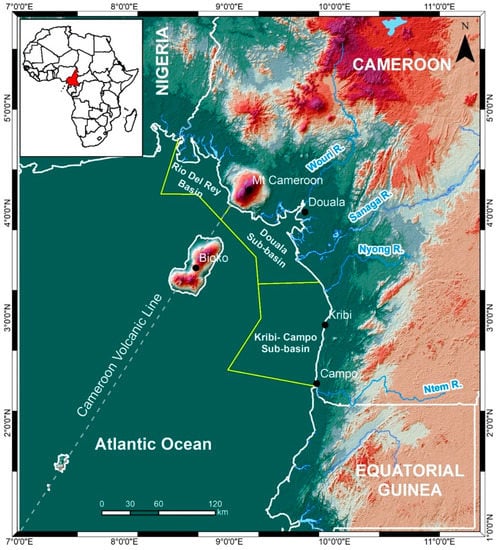
Figure 1.
Segmentation of the Cameroon Atlantic Margin (CAM), showing the Rio Del Rey Basin, the Douala and the Kribi-Campo Sub-basins [], with respect to mainland of Cameroon and Africa (inset). The Cameroon Volcanic Line is indicated by grey dashed line.
Some authors [,,] stated that the salt unit does not exist in the Atlantic domain. Particularly, the works of [] described that the extent of salt units does not exceed 1° N latitude. The formation of folds observed in this segment is associated with the reactivation of transfer faults and not formed by salt tectonics. However, other studies [,,,,,,,,] highlighted salt units in the southern Cameroon Atlantic Basin. These studies date the saliferous sequence as older than Cenomanian. The works of [] described a salt diapir in the Kribi-Campo domain, and the recent study of [] indicated, despite the results of those previous authors, the existence of strip-shaped salts in the deep marine domain.
The salt unit is a central element in understanding the structure and stratigraphic framework of the CAM and the sedimentary evolution of basins along the SW African Margin.
This work aims to re-examine the occurrence of salt units in the Kribi-Campo sub-basin, using 2D seismic reflection and borehole data while investigating its depositional context and associated petroleum implications
2. Materials and Methods
Data used in this study were provided by the National Hydrocarbon Corporation of Cameroon (NHC). They include four 2D-seismic-depth migrated reflection profiles (SS1–SS4) and fifteen boreholes (W1–W15, in Figure 2). All those data were acquired from the continental shelf to the deep basin. They cover an area of 7200 km2. The seismic profiles extend down to 10 km, and the borehole depth varies from 1 to 4 km below the seabed, penetrating down to Aptian/Albian age units. We analyzed the data seeking evidence for salt units beneath the Top Albian unconformity and mapping their spatial extent.
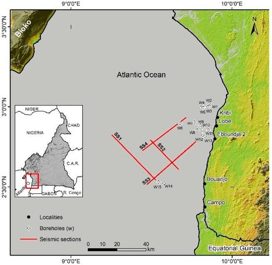
Figure 2.
Location of seismic reflection profiles (SS1–SS4) and boreholes (W1–W15) in the study area (revised from []).
The methodology included tying seismic data with well data and prospecting internal and external forms of salt facies on the seismic data. The first step consisted of mapping the Top Salt surface on seismic profiles. Then, salt facies were identified based on seismic stratigraphy concepts [,,], guided by observations from recent studies [,]. This method has the potential to identify salt units and highlight their external configurations.
3. Results
3.1. Borehole Data Analysis
The analysis revealed a salt unit only in one borehole—the Kribi Marine-1 (W6 in Figure 2). In this well-known borehole, the saliferous unit thickness exceeds 1500 m (the bottom of the unit was not recovered). This unit also exhibits thin dark shale streaks and traces of anhydrite of Aptian age (Figure 3).
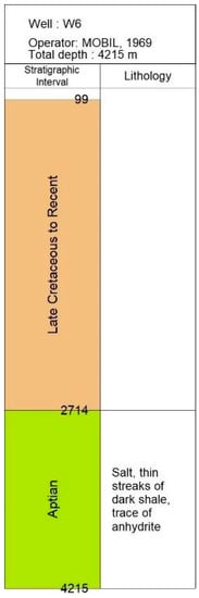
Figure 3.
Profile of Well W6 (Kribi Marine-1), showing salt units in the Aptian section (2714–4215 m) of the Kribi offshore domain (see Figure 2 for location).
3.2. Seismic Analysis
3.2.1. Well to Seismic Tie
The well to seismic tie analysis reveals that salt units are located beneath the Top Albian unconformity (Red line, Figure 4), which truncates the pre-Cenomanian period. These units appear in the early to mid-Aptian strata. The fence diagram in Figure 4 illustrates the spatial distribution of the salt unit and its upper surface.
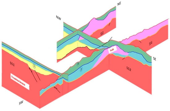
Figure 4.
A fence diagram showing the spatial distribution of salt units on SS1–SS4 profiles (pink layer) in the Kribi-Campo sub-basin, based on an integrated seismic borehole interpretation (see Figure 2 for section location). From the bottom upwards, yellow surface ① indicates the Early Aptian transgressive sequence covering the Precambrian basement (red). Blue surface ② indicates the top salt horizon of Late Aptian age. Red surface ③ indicates the Top Albian unconformity. The yellow, blue and green layers represent the LST, TST, and HST respectively.
3.2.2. Seismic Data Analysis
The NW-trending SS1 seismic reflection profile is located in the deeper domain and provides no evidence of a salt unit.
In the NW-trending SS2 profile, the salt unit is well observed and characterized by a localized portion of chaotic facies, which is associated with wavy internal reflections of average amplitudes and variable frequency. Its external configuration shows a diapir shape. Its thickness varies along the section and reaches ~3 km above the Kribi-Campo High. This salt diapir is associated with faults.
Additional evidence for salt units appears in the NE-trending profile SS3, showing similar seismic facies in SS2. These units lie directly over the basement unit (Figure 4). It exhibits two patterns—diapir and strip shaped. Its thickness reaches a value of 4 km towards the coastline. This salt body is also associated with faults developed at the top.
The NE-trending profile SS4 exhibits similar seismic characteristics to the NE part of the parallel line SS3. The salt unit appears under the continental shelf domain in varying thicknesses, reaching 2 km to the east. Diapir and strip shapes of salt units are observed.
4. Discussion
The results obtained in this study show the presence of several salt units in the offshore domain of the Kribi-Campo sub-basin. Its three-dimensional body comprises diapir and strip shapes. These observations are in accordance with some of the previous studies [,,]. This study [] also shows that the salts were deposited during the rift-drift period following the marine incursion. In comparison with [,], the depositional context of the salt units seems to be associated with a significant sea-level fall induced by a margin uplift, which probably occurred during Aptian times.
The diapir structure can form oil and gas traps, an important type of petroleum []. Some seismic characteristics identified within the salt unit might reflect DHIs. These observations correspond to those of [], which identified similar hydrocarbon indicators in the offshore Kribi-Campo sub-basin.
5. Conclusions
Seismic and borehole data confirm the presence of Aptian salt units in the offshore domain of the Kribi-Campo sub-basin. The units appear as diapir and strip shapes. Their formation relates to a significant sea-level fall induced by a margin uplift, which occurred during Aptian times. These salt units may form stratigraphic hydrocarbon traps.
Author Contributions
M.-F.M.E.: Conceptualization, methodology, formal analysis and writing—original draft; J.Q.Y.A.: review and supervision; M.Y.: resources, methodology and review; S.E.A.B.: resources and review; E.Y.L.: review and supervision. All authors have read and agreed to the published version of the manuscript.
Funding
This research received no external funding.
Institutional Review Board Statement
Not applicable.
Informed Consent Statement
Not applicable.
Data Availability Statement
Not applicable.
Acknowledgments
The authors are thankful to the National Hydrocarbon Corporation of Cameroon (SNH) for providing data, as well as the Earth Sciences Department of the Faculty of Science of the University of Yaoundé I.
Conflicts of Interest
The authors declare no conflict of interest.
References
- Le, A.; Huuse, M.; Redfern, J.; Irving, D. Seismic Characterization of a Bottom Simulating Reflector (BSR) and Plumbing System of the Cameroon Margin, West Africa. Mar. Pet. Geol. 2015, 68, 629–647. [Google Scholar] [CrossRef]
- Phillips Inc. Geologic Development and Hydrocarbon Potential of the Douala Basin, Cameroon, Text and Figures; Phillips Inc.: Amsterdam, The Netherlands, 1990; p. 34. [Google Scholar]
- Pauken, R. Sanaga Sud Field, offshore Cameroon, West Africa. In Giant Oil and Gas Field of the Decade 1978–1988; Halbouty, M., Ed.; AAPG Memoir: Tulsa, OK, USA, 1992; pp. 217–230. [Google Scholar]
- Nguene, F.R.; Tamfu, S.F.; Loule, J.P.; Ngassa, C. Paleoenvironments of the Douala and Kribi/Campo sub basins, in Cameroon, West Africa. In Géologie Africaine: 1er Colloque de Stratigraphie Et de Paléogéographie Des Bassins Sédimentaires Ouest-Africains; 2e Colloque Africain de Micropaléontologie, Libreville, Gabon, 6–8 Mai 1991; Recueil Des Communications; Curnelle, R., Ed.; Elf Aquitaine: Courbevoie, France, 1992; pp. 129–139. [Google Scholar]
- Helm, C. Quantification des Flux Sédimentaires Anciens à L’échelle d’un Continent: Le cas de l’Afrique au Méso-Cénozoïque. Ph.D. Thesis, Université Rennes 1, Rennes, France, 2009; p. 299. [Google Scholar]
- Yem, M. Caractérisation par Imagerie Géophysique de la Couverture Sédimentaire des Bassins Offshores Profonds du Nord de la Cyrénaïque et de Douala/Kribi-Campo: Éléments de Géologie Pétrolière. Ph.D. Thesis, Université de Yaoundé I, Yaoundé, Cameroon, 2012; p. 143. [Google Scholar]
- Loule, J.P.; Jifon, F.; Angoua-Biouele, S.E.; Nguema, P.; Spofforth, D.; Carruthers, D.; Watkins, C.; Johnston, J. An opportunity to re-evaluate the petroleum potential of the Douala/Kribi-Campo Basin, Cameroon. Spec. Top. Pet. Geol. 2018, 36, 61–70. [Google Scholar] [CrossRef]
- Mienlam Essi, M.-F.; Yene Atangana, J.Q.; Abate Essi, J.M.; Yem, M.; Angoua Biouele, S.E.; Nguema, P.; Tsimi Ntsengue, C. Stratigraphical nature of the Top Albian surface, from seismic and wells data analyses, in the south Sanaga area (Cameroon Atlantic margin): Palaeogeographical significance and petroleum implications. Mar. Pet. Geol. 2021, 129, 105073. [Google Scholar] [CrossRef]
- Secke Beckonga Guott, B.; Yem, M.; Yene Atangana, J.Q.; Nkoa Nkoa, P.E.; Angoua Biouele, S.E.; Niyazi, Y.; Eruteya, E.O. Seismic geomorphology of a Late Cretaceous submarine channel system on the continental slope of Kribi/Campo sub-basin, offshore Cameroon. Mar. Pet. Geol. 2022, 145, 105865. [Google Scholar] [CrossRef]
- Pautot, G.; Renard, V.; Daniel, J.; Dupont, J. Morphology, limits, origin and age of salt layer along south Atlantic African margin. Am. Assoc. Pet. Geol. Bull. 1973, 57, 1658–1671. [Google Scholar]
- Benkhélil, J.; Giresse, P.; Poumot, C.; Ngueutchoua, G. Lithostratigraphic, geophysical and morpho-tectonic studies of the south Cameroon shelf. Mar. Pet. Geol. 2002, 19, 499–517. [Google Scholar] [CrossRef]
- SPT/Simon Petroleum Technology (Grapevine, TX, USA). Petroleum Geology and Hydrocarbon Potential of Douala Basin, Cameroon. Unpublished Report. 1995.
- Brownfield, M.E. Assessment of Undiscovered Oil and Gas Resources of the West-Central Coastal Province, West Africa; U.S.G.S.: Reston, VA, USA, 2016; p. 41. [Google Scholar]
- Davison, I. Geology and Tectonics of the South Atlantic Brazilian Salt Basin; Geological Society Special Publications: London, UK, 2007; pp. 345–359. [Google Scholar]
- Lawrence, S.R.; Munday, S.; Bray, R. Regional geology and geophysics of the eastern Gulf of Guinea (Niger Delta to Rio Muni). Lead. Edge 2002, 21, 1112–1117. [Google Scholar] [CrossRef]
- Mitchum, R.M.; Vail, P.R.; Sangree, J.B. Seismic stratigraphy and global changes of sea-level, Part 6: Stratigraphic interpretation of seismic reflection patterns in depositional sequences. In Seismic Stratigraphy-Applications to Hydrocarbon Exploration; Payton, C.E., Ed.; AAPG Mem.: Tulsa, OK, USA, 1977; pp. 117–133. [Google Scholar]
- Bernitsas, N.; Sun, J.; Sicking, C. Prism waves—An explanation for curved seismic horizons below the edge of salt bodies. In Proceedings of the 59th Annual International Conference and Exhibition EAGE, Extended Abstracts, Geneva, Switzerland, 26–30 May 1997; p. E38. [Google Scholar]
- Lafond, C.; Jones, I.F.; Bridson, M.; Houllevigue, H.; Kerdraon, Y.; Peliganga, J. Imaging deep water salt bodies in West Africa. Lead. Edge 2003, 22, 893–896. [Google Scholar] [CrossRef]
- Liu, Z.; Li, J. Control of salt structures on hydrocarbons in the passive continental margin of West Africa. Petrol. Explor. Develop. 2011, 38, 196–202. [Google Scholar] [CrossRef]
- Jones, I.F.; Davison, I. Seismic imaging in and around salt bodies. Special section: Salt basin model building, imaging, and interpretation. Interpretation 2014, 2, SL1–SL20. [Google Scholar] [CrossRef]
Disclaimer/Publisher’s Note: The statements, opinions and data contained in all publications are solely those of the individual author(s) and contributor(s) and not of MDPI and/or the editor(s). MDPI and/or the editor(s) disclaim responsibility for any injury to people or property resulting from any ideas, methods, instructions or products referred to in the content. |
© 2023 by the authors. Licensee MDPI, Basel, Switzerland. This article is an open access article distributed under the terms and conditions of the Creative Commons Attribution (CC BY) license (https://creativecommons.org/licenses/by/4.0/).