Article

Scaling Landscape Fire History: Wildfires Not Historically Frequent in the Main Population of Threatened Gunnison Sage-Grouse

Program in Ecology and Evolution, University of Wyoming, Laramie, WY 82071, USA
Fire 2024, 7(4), 120; https://doi.org/10.3390/fire7040120
Submission received: 20 February 2024 / Revised: 29 March 2024 / Accepted: 4 April 2024 / Published: 6 April 2024
(This article belongs to the Special Issue Effects of Wildfire on the Biota)

Abstract

:
The main population of ~5000 threatened Gunnison sage-grouse (GUSG; Centrocercus minimus) in Colorado depends on sagebrush plants that are killed by wildfires, with recovery taking decades, so frequent fire is a threat, but did it occur historically? Early land surveys showed that the historical (preindustrial) fire rotation (FR), the expected period to burn area equal to a focal land area, was 90–143 years in GUSG ranges, which is not classed as frequent fire (≤25 years). However, recent research, based on fire scars on trees at ten sites near sagebrush, suggested some frequent fire historically in the main population. That study was not spatial, essential to estimate FR, so spatial data were created in GIS with land-survey reconstructions, survey dates, fire-scar sites, mapped sagebrush, and Thiessen polygons around sites. The previous study assumed fires that burned 2+ sites likely burned across sagebrush. Historical FRs were calculated several ways over a common period. A recovery estimate of FR was 90–135 years, a land-survey estimate was 82–131 years, and three spatial scar-based estimates were 93–107 years, showing agreement. However, the comparison found that only 8.8% of the land-survey fire area was detected at fire-scar sites. Detailed analysis showed that 10 fire-scar sites were insufficient to detect historical fire sizes and distributions across the large 168,753 ha sagebrush area. Adequate fire reconstruction could require ~45–60 fire-scar sites, making it feasible to study only ~30,000 ha of sagebrush. Using the two remaining methods, which cross-validate, showed frequent fire did not occur historically in the study area, as historical FRs were 82–135 years.

1. Introduction

Populations of declining species, such as the federally threatened Gunnison sage-grouse (Centrocercus minimus; GUSG; Figure 1a), could be at further risk if wildfires exceed their historical (preindustrial) rates and patterns, becoming more frequent [1]. GUSG depend upon large, contiguous areas of sagebrush ([2], Figure 1b), that are typically killed in wildfires and require decades to recover [3]. GUSG can move seasonally across large landscapes but may have little ability to adjust to sagebrush loss [4]. So, exceptional large wildfires are a threat, and historical reconstructions provide a key baseline about this threat [3,5,6]. From 1985–2008, wildfires increased in the Colorado Plateau area, containing current GUSG areas, but the rates were long relative to historical fire rotations of 90–143 years [5,7]. A fire rotation (FR) is the expected period to burn across an area equal to a landscape of interest, although some reburning may occur [5]. This 90–143 year FR contrasts with a report of “frequent” historical fires in the GUSG sagebrush habitat, based on fire scars.
Sagebrush landscapes have been significantly altered, causing declines in GUSG populations, by chemical and mechanical treatments that killed sagebrush to increase livestock forage and enable agriculture and other land uses, including infrastructure, urbanization, energy development, and recreation [9]. GUSG totaled ~5000 in the latest count (https://www.usgs.gov/centers/fort-collins-science-center/science/understanding-population-trends-gunnison-sage-grouse, accessed on 10 December 2023). Nearly all the sagebrush range of GUSG analyzed in Simic et al. [8] was in mountain big sagebrush (Artemisia tridentata ssp. vaseyana), with only small areas of Wyoming big sagebrush (Artemisia tridentata ssp. wyomingensis) and low sagebrush (Artemisia arbuscula) (Figure 2). Therefore, this paper focuses on historical fires in mountain big sagebrush near Gunnison (38°32′40″ N 106°55′36.9″ W).
What is debated here about historical wildfires in the GUSG habitat in mountain big sagebrush is at what rate did these wildfires occur historically and were rates fast enough so that the fires could be considered “frequent” as described by Simic et al. [8] from small plots? The best estimates of rates of fire are based on the fire rotation (FR), the expected period for wildfires to burn an area equal to the area of a landscape of interest, although some reburning may occur [5]. However, FR also estimates the expected mean fire interval (MFI) of spreading fires at any point in the landscape. FRs are calculated by summing fire areas over a landscape and period of interest, then dividing the period by the fraction of the landscape burned. For example, if an area equal to 20% of a landscape burned in 30 years, the FR is 30/0.20 = 150 years. FRs provide best estimates of rates, since most fires are small, if frequent, yet most of the burned area is from the few infrequent large fires. Small, frequent fires typically do little of the fire work. For example, between 1980–2020 in the San Juan Mountains, which includes part of the study area, only 35 fires ≥ 225 ha in area, which are <1% of the 4937 total fires, accounted for 95% of the total burned area [10].
Small-plot fire-scar methods in forests, such as Simic et al. [8], are consequently measuring intervals between mostly small fires, and individual small plots do not estimate FRs in sagebrush. Fire areas cannot be measured in small plots, so fires and intervals are just counted and called “fire frequency” and “mean fire return intervals”, as though equal in area. Also, fire-scar estimates from small plots are only from nearby forests, since sagebrush does not record long fire records [3]. Yet, only a fraction of forest fires likely burned in sagebrush. Simic et al. [8] may not have intended to use their data spatially, but since individual small plots in the forests do not estimate FRs in sagebrush, there is no other choice. So, here I study two questions: (1) were there frequent historical fires in mountain big sagebrush in the Gunnison area and (2) what is the best spatial fire-scar method and how must it be scaled so as to accurately estimate historical FRs in mountain big sagebrush?

Background on Landscape-Scale Spatial Fire Histories

An earlier review [3] estimated historical FRs in mountain big sagebrush across the western USA were about 150–300 years, based on the following: (1) adjacency correction of fire-scar data from small plots in forests near sagebrush, (2) paleo-charcoal reconstructions, (3) fire-scar data from a fine mosaic of forest and sagebrush, and (4) estimated recovery time after fire in sagebrush. Adjacency correction uses the ratio of modern FRs in sagebrush and forests, and then applies this to historical forest FRs. Paleo-charcoal records can estimate FRs from intervals between charcoal peaks. Fire-scar data in fine forest sagebrush mosaics need no adjacency correction if fires are likely burning the whole area. FRs likely are 2–3 times the post-fire recovery period, as [3] explains this provides sufficient time for sagebrush to exist in a mature state and produce seed. None of these methods were explicitly spatial.
Spatial fire-history methods, which contrast with fire histories from small plots [8], scaled to the most significant infrequent larger fires, developed at the landscape scale (e.g., 1000 ha+) since the mid-1990s (e.g., [11,12]). Small plots are used to date fires from scars, but fire frequency is not calculated. Instead, spatial “fire-year” maps are created across multiple plot locations (e.g., 30) in landscapes, to recreate fire areas in each year. These maps are used to estimate FRs, which also provide expected MFIs at points and fire-size distributions. Newer methods also use general land office land-survey data, which include systematically surveyed line-intercept data across large landscapes, typically from the late 1800s. These enable direct estimates of historical wildfire FRs, patch sizes, and locations [5,6]. This section-line method, using grass-dominated areas to indicate fires in sagebrush, was used to reconstruct historical FRs across ~2 million ha of sagebrush in four western states [6] and also ~219,000 ha across most of the current GUSG habitat area [5]. Historical FRs in mountain big sagebrush, which dominates the Gunnison area, were revised from the earlier 150–300 year estimate [3] down to 137–217 years across mountain big sagebrush in Idaho, Nevada, Oregon, and Wyoming study areas [6], and 90–143 years across mountain big sagebrush supporting GUSG populations in Colorado [5].
Wildfires likely cannot be reconstructed directly and accurately across sagebrush or other shrub-dominated landscapes other than by landscape-scale spatial fire histories from fire-year maps or from land-survey records. Direct observations in early records and atlases, that mapped fires, might exist and be found. However, land-surveys, records, and atlases only provide data for a limited period of decades near and before Euro-American settlement, in contrast with other fire-scar spatial fire histories that can span several centuries. What are the main questions about spatial fire-history methods addressed here? What would previous methods and corrections for small-plot fire-scar data tell us about historical FRs specifically in mountain big sagebrush in the Gunnison area? Could the small-plot fire-year data in the Simic et al. [8] dataset be turned into a spatial fire history? How would this compare with the Bukowski and Baker [5] land-survey FR estimate? Could a combination of spatial methods overcome the limitations of each?

2. Materials and Methods

First, an overview. Here, I first used one previously published method to estimate FR in sagebrush [3]. Then, I expanded on the observations in Simic et al. [8] about fires that burned 2+ fire-scar sites, by creating spatial fire-history datasets and using them to estimate FR in sagebrush. Finally, I compared them with land-survey reconstructions to understand which methods are best to estimate FRs in sagebrush, to determine whether fires were historically frequent in sagebrush.
I downloaded the spatial datasets for GUSG historical habitats, fire-scar dates, and land-survey data usable in the ArcGIS Pro 3.2 (ESRI, Redlands, CA) geographical information system (GIS). The study area was defined by the historical Gunnison sage-grouse habitat map from Colorado Parks and Wildlife (https://hub.arcgis.com/datasets/1bab23cd9f274742ae1e38afa6e6c44f/about, accessed on 2 December 2023). However, to create a closed polygon enclosing the GUSG habitat area near Gunnison, which is compatible with the analysis area used by Simic et al. [8], I created borders on the western and northeastern boundaries, both of which otherwise would include a substantial area without fire-scar evidence (Figure 2). The resulting study area is 362,017 ha. I downloaded the Simic et al. [8] fire-scar data from NOAA’s National Centers for Environmental Information under “Simic fire data from Antelope Hill, Western Slope IMPD USAEH001” (https://www.ncei.noaa.gov/access/paleo-search/?dataTypeId=12, accessed on 7 December 2023). I used the section-line land-survey records for the Bukowski and Baker [5] study area (See Data Availability). I downloaded Landfire 2020 raster maps of Existing Vegetation Types (EVTs) from the Landfire site: (https://landfire.gov/version_download.php#, accessed on 14 November 2023), and extracted “7126 Intermountain Basins Montane Sagebrush Steppe”, which is described as primarily mountain big sagebrush. I also downloaded “7080 Intermountain Basins Big Sagebrush Shrubland”, Wyoming big sagebrush, and “7064 Colorado Plateau Mixed Low Sagebrush Shrubland”, Low sagebrush. This research was underway before the Landfire 2022 data were released. Datasets were projected to NAD83 UTM Zone 13N.
These datasets required some processing in ArcGIS Pro. I input the Simic et al. [8] fire-scar site locations from latitudes and longitudes in FHX files, and labeled them with three-letter codes used in Simic et al. (Table 1). To divide the study area into influence zones closest to each fire-scar site, I used ArcGIS’s “Create Thiessen Polygons” (also called Voronoi polygons). The original land-survey data used here are the section-line data collected by teams of surveyors between 1876–1892 (median 1880). They surveyed 1.61 km (1 mile) section-line lengths between section corners. They broke section lines into smaller segments, whose beginning and ending were recorded, when they encountered a disturbance (e.g., a fire) or change in vegetation (e.g., forest to sagebrush). At the end of a segment, a vegetation description was recorded, including dominant trees and shrubs in order of abundance and with qualitative density descriptors (e.g., dense, scattered). The section-line dataset in the study area has 3640 line segments covering 3305 km of total line length, so the mean segment length was 0.91 km or 0.56 miles. I reclassified the surveyor’s original vegetation descriptions into just sagebrush, sagebrush with trees, other, and not recorded. I also included Bukowski and Baker’s [6] reconstructions of sagebrush fires, which are fine polygons from turning section-line segments into Thiessen polygons (Figure 3).
The first and previously applied approach was to estimate historical FRs in sagebrush as 2–3 times the estimated period for sagebrush to recover after a fire to its pre-fire condition, based on data on the ratio of known FRs to recovery periods in several ecosystems [3]. Some consistency in these ratios suggests that plants need substantial periods of maturity and seed and foliage production, after fully recovering from a fire, before again suffering widespread mortality. Simic et al. ([8] p. 8) reported, regarding the recovery period at their sites: “Based on the rate of recovery estimated from 0 to 20 years after fire, we project that sagebrush cover would take approximately 45 years to fully recover to pre-fire levels”. Thus, the estimate here for historical FR in mountain big sagebrush in the Gunnison area was simply 2–3 times 45 years.
Landscape-scale spatial fire histories were the second to fifth approaches to estimate FRs in sagebrush. The second and also previous approach was directly from reconstructed fires based on early land-survey records, with historical FRs reported as 90–143 years across most of the GUSG range [5]. This estimate is replaced here by a new calculation of FR using land-survey data specific to the study area. This was calculated as the land-survey observation period, which is 22–35 years [6], divided by the fraction of mountain big sagebrush area, 168,753 ha, burned during the observation period (Figure 2 and Figure 3).
After using these two previous methods, how might a landscape-scale spatial fire history be created from the Simic et al. [8] data? Simic et al. recognized that the only evidence they had, that fires in forests also burned sagebrush, was the occurrence of fire dates at two or more of their ten sites, which may suggest fire spread between these sites, although disjunct ignitions may also occur. Their assumption can be used to calculate increasingly precise spatial estimates of FRs across mountain big sagebrush, to show alternative spatial methods to estimate FRs and whether they agree. I used nine fire years found at 2+ sites during their common period from 1684 to 1892 (1690, 1791, 1798, 1824, 1834, 1842, 1860, 1872, 1879) to estimate FRs in sagebrush. In the third method, I assumed the fraction of fire-scar sites burned, by fires detected at two or more fire-scar sites, estimates fraction of sagebrush burned. Fourth, I assumed whole Thiessen polygons burned (Table 1) on the shortest path between polygons. Fifth, I assumed just the mountain big sagebrush area (Table 1) in the polygons burned.
Finally, do land-survey reconstructions identify fires also identified by fire-scar sites? To test this, I used the 22–35 year period before the land-survey years, which should show dated fires thought to have burned between 2+ fire-scar sites or near a single site. I also counted land-survey fire patches within 1 km of the edge of forests near fire-scar sites, to see how many land-survey fire patches could have feasibly been detected at fire-scar sites. If a fire is detected at a fire-scar site, and it spreads to sagebrush, it should show up a short distance into the sagebrush.
Land-survey data also provide estimates of the size distribution of fires (Figure 2 and Figure 3). The Bukowski and Baker [5] reconstruction of historical fires contained reconstruction polygons for each fire, so I clipped these in GIS with the study area boundary (Figure 2), then recalculated the areas of the fire polygons. These were then compiled in a dataset and the attributes (e.g., mean) of the fire-size distribution were calculated in Minitab 21.4.2 (Minitab, Inc., College Park, MD, USA).

3. Results

3.1. Fire-Rotation Estimates from the Five Methods

Methods used here led to five estimates of FR, that are quite similar (Table 2). The first FR estimate, based on the post-fire recovery period for sagebrush, is 90–135 years. There are four landscape-scale estimates. The second FR estimate, based on land-survey reconstructions, found the total fire area in mountain big sagebrush (Figure 2) was 45,150 ha, so this FR estimate for the 22–35 year observation period is 82–131 years.
Spatial fire-scar estimates began with the third method, a simple fraction-burned estimate. Eight fires burned two of ten sites (8 × 0.2) plus one fire burned four of ten sites (1 × 0.4), so the estimated historical FR for the 209 years from 1684 to 1892 is 105 years. The fourth method uses whole Thiessen areas (Table 2) as the area burned in a fire year (Table 3), which introduces variability in areas represented by each fire-scar site. This method also assumes that fires that burn two sites not directly connected, include one or more “Connection” sites (Table 3). Summing across Thiessen polygons, that are bold F entries (Table 3), only for fires found at 2+ sites, the results showed 709,233 ha burned and 792,834 ha for F or C entries in Table 3. Therefore, the FR is 107 years for just F entries and 95 years for F and C entries, for an FR range from 95 to 107 years. For method 5, the calculation was the same, except the areas summed in Table 1 were just the mountain big sagebrush areas. For method 5, the estimated FR range is 93–106 years.

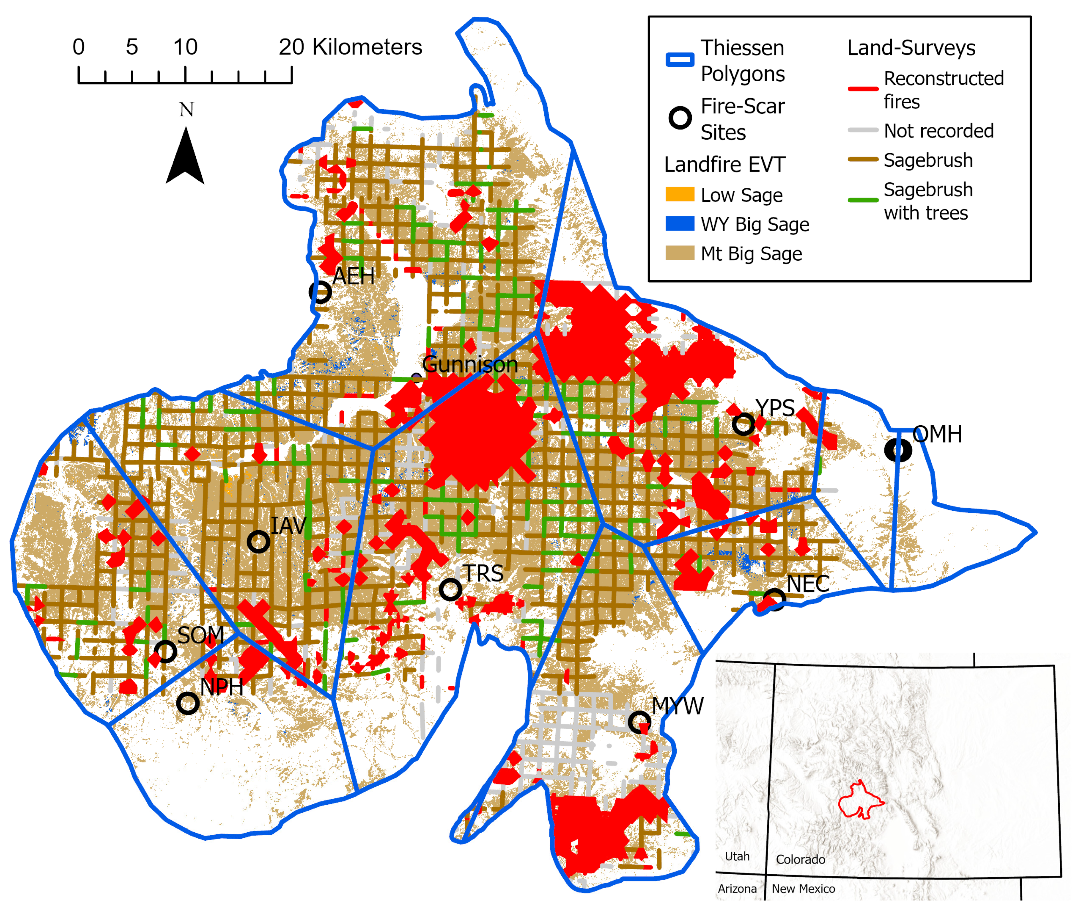
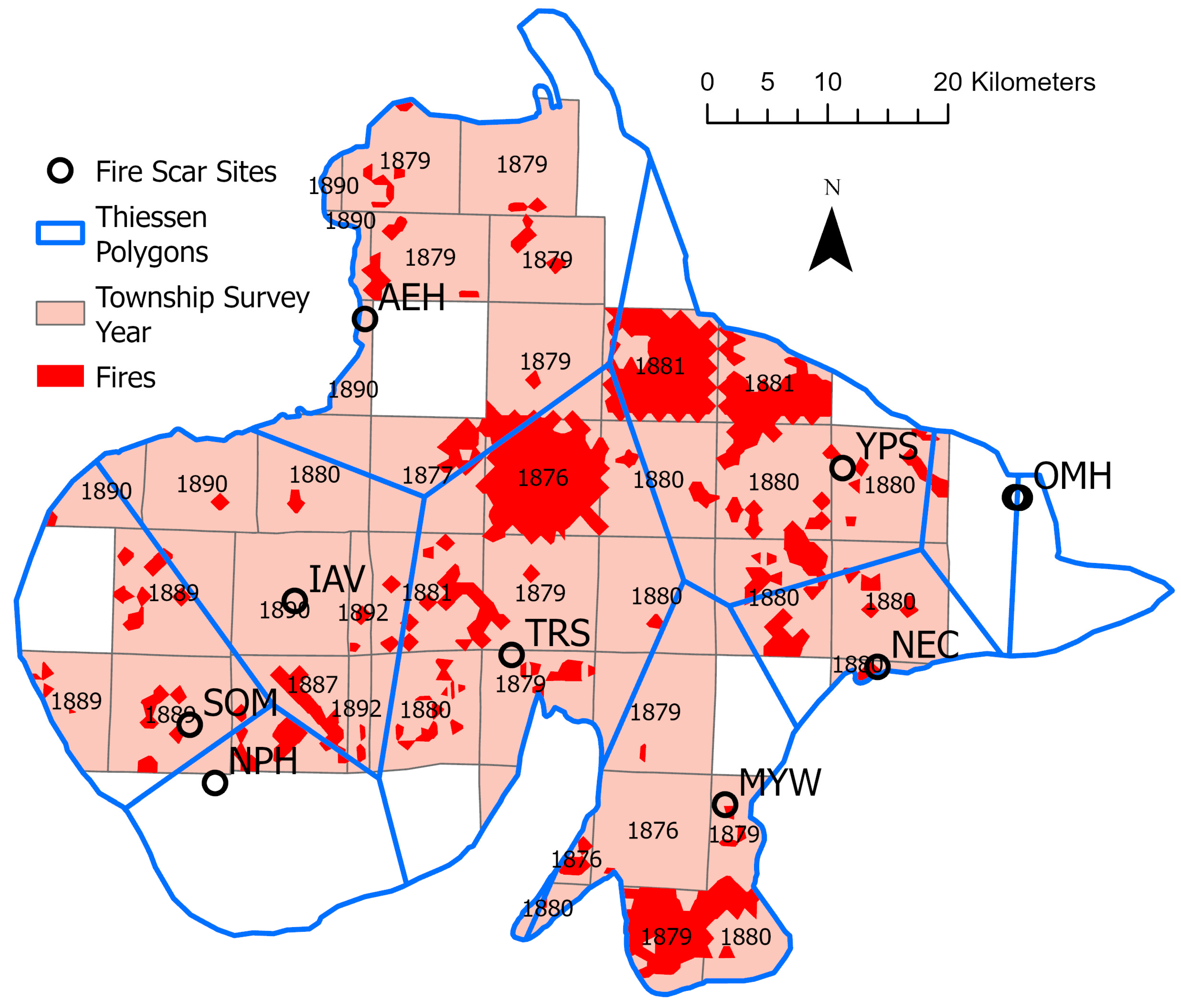
3.2. Comparing Land-Survey and Spatial Fire-Scar Reconstructions of Fire Years

Land-survey fires were only in sagebrush and fire-scar sites only in forests, so a small gap is expected between a fire-scar site and a land-survey area nearby (Figure 3). Most of the total burned area, based on land surveys, was in scattered medium-sized patches plus three large patches: (1) south of MYW, (2) on the border between AEH and TRS, and (3) in the northern part of YPS (Figure 3). However, there are no fire-scar sites near these three large patches or near most medium-sized patches, so most of the total land-survey burned area could not be assigned to a fire-scar year. Also, fire years found at the fire-scar sites could not be assigned to most patches, since they were not near these patches, although a few inferences can be made. The count of land-survey burns within 1 km of the edge of forests near fire-scar sites found eleven of sixty total patches (18.3%), with one at AEH, MYW, and NEC, two at SOM, and three at TRS and YPS. These totaled 3969 ha, only 8.8% of the total 45,150 ha of the land-survey burned area. This means that 81.7% of the 60 land-survey burns and 91.2% of their burn area were not near a fire-scar site, and could not have been detected by the ten fire-scar sites.
This result alone is enough to show that the fire-scar network was not adequate to detect most historical fires, but could some of the larger historical fire years be detected? Land-surveys could detect fires back as far as 1841–1852 (Table 3), so three (1860, 1872, 1879) of the nine two-site fires that were thought by Simic et al. [8] to have burned substantial areas in sagebrush, should be represented in land-survey maps of the fires (Table 3). There are four other one-site fire years (1852, 1868, 1873, 1880) that may or may not have burned in sagebrush, for seven total fire-years in the detection period (Table 3).
The first large fire (two-sites) thought to have burned sagebrush, in 1860, could be only represented by small land-survey burns near NEC and TRS (Figure 3). There is no continuous land-survey burn between NEC and TRS (Figure 3); thus, 1860 was not a large fire year, but possibly separate small ignitions. Small burns near NEC could be from 1852, 1860, or 1880 (Table 3), and those near TRS could be from 1860, 1872, or 1879 (Table 3), so there is some uncertainty.
The second and potentially largest fire in sagebrush, the 1872 fire detected at four fire-scar sites (Table 3), was also not a large fire year. Most important, a large land-survey fire did not occur at or between YPS and TRS (Figure 3), where fire-scar sites recorded the 1872 fire. So, 1872 was not a large fire year. Unfortunately, there are no land-survey data for Thiessen polygons at OMH and OML, where this fire was recorded by scars. However, if the 1872 fire had occurred there, it would only have burned at most 2644 ha of mountain big sagebrush, since that is all the sagebrush in that area (Table 1). Since there were small patches near YPW and TRS (Figure 3), these likely were small separate ignitions.
The third large fire in sagebrush, in 1879, detected by fire scars, between AEH and TRS could have occurred, as the land-survey data are not adequate to test it. A township next to AEH lacks evidence, two townships from AEH to TRS were surveyed in 1876–1877 before the 1879 fire year and so lack evidence, and townships near TRS could have been surveyed in 1879 before the 1879 fire started. If this 1879 fire occurred, it together could have burned 20,000+ ha.
There were also four one-site fire years (1852, 1868, 1873, 1880) that are expected to be small and may or may not have burned sagebrush. The 1852 fire year at NEC was not a large fire year, as there is only a small land-survey burn near NEC (Figure 3). Regarding the 1868 fire recorded at MYW, there are no land-survey data for the 1876 township west of MYW (Figure 3). There is a small patch of land-survey burned area south of MYW, that could possibly have connected up through this missing township area, to the large patch of burned area south of MYH. If so, the 1868 fire at MYW could have reached 10,000 ha+, and be among the largest fire patches, but an absence of nearby fire-scar sites leaves this highly uncertain. The 1873 fire at NPH has at most a small land-survey burn near it, but 1873 was only at this site. The 1880 single-site fire is possible at NEC, in a township surveyed in 1880, as a small land-survey burn is near there, making this a fire-scar detection of a small land-survey burn (Figure 3).
There are large land-survey fire patches that do not match up with the fire years detected at the fire-scar sites. There is nearly a full township of land-survey fires in the northwest corner of the YPS Thiessen polygon and another half township of land-survey fires to its east (Figure 3), both surveyed in 1881. Another piece of fire extends into the township to its south, surveyed in 1880. This block of fire across three townships has a sharp boundary with the AEH township, to its west, surveyed in 1879 that shows no large burn. This suggests this 1.6+ township (~15,000 ha) burn was in 1880, or possibly late 1879, as it was found in surveys in 1880 and 1881, but not 1879. This would be the largest fire in the land-survey data in the study area. It was not detected at the nearest fire-scar site at YPS, because YPS is well outside this 1879/1880 fire area. The only site recording in 1880 was NEC, >20 km to the southeast, which is unlikely to be part of this fire. The 1879 fire year is also recorded far away at AEH and TRS (Table 3), and there is no interconnecting fire area. Similarly, there is a large fire patch of 10,000 ha+ in the northern TRS Thiessen polygon for a fire that occurred in 1876 or before. This cannot be any of the fires detected at fire-scar sites, as there is no connecting burned area to those sites as they are all > 10 km from the fire. These two significant cases show that the fire-scar network was insufficiently dense to detect even a very large fire and the largest fire found by the land surveys.
Summing up, the three 2+-site fires in 1860, 1872, and 1879 that Simic et al. thought likely to have spread across sagebrush, were not large fires in sagebrush in 1860 and 1872. The four 1-site fires in 1852, 1868, 1873, and 1880, that Simic et al. thought were not likely to have spread across sagebrush, were small in 1852, 1873, and 1880, but potentially large in 1868. Furthermore, the fires in 1879/1880, likely the largest in the land-survey area, and another large fire in or before 1876, were not detected by the ten fire-scar sites. The 1879 fire year at AEH and TRS could not be validated due to insufficient land-survey evidence. The set of detectable fire years was 1852, 1860, 1868, 1872, 1873, 1880, and 1879/1880, or seven. The net accuracy of the ten fire-scar sites in correctly identifying whether fires had or had not spread across sagebrush was 0/2 for large fires and 3/5 for small fires for a total of 3/7 fires or 43%. However, two large land-survey fires also were not detected by the fire-scar sites. The ten fire-scar sites could not adequately detect sizes and abundances of fires, even very large fires, that occurred historically in the sagebrush habitat in the study area.
Consequently, FR estimates from methods 3–5 (Table 2), which appeared to agree with FRs from methods 1–2, are likely invalid, as are fire-frequency estimates of Simic et al. [8], from small plots, that implied fires were frequent in sagebrush in the study area. The remaining unrefuted estimates of historical FRs in sagebrush in the study area are 90–135 years from the sagebrush recovery period after fires and 82–131 years from land-survey reconstructions, which closely agree (Table 2). These results show that frequent fires did not occur historically in sagebrush in the study area.

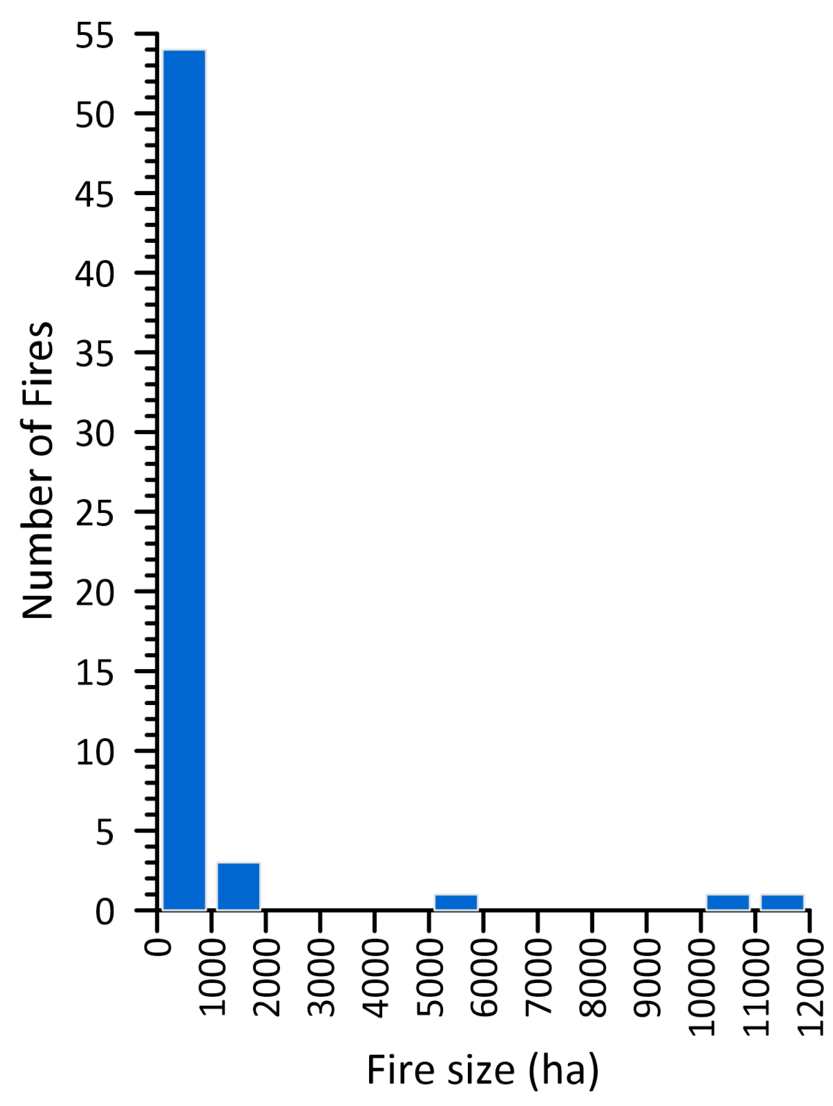
3.3. What Are the Characteristics of the Fire-Size Distribution from Land-Survey Reconstructions?

The fire-size distribution from the land-survey reconstructions was inverse-J shaped (Figure 4) from 60 reconstructed burn patches, with a mean area of 753 ha and three burns of 5285 ha, 10,249 ha, and 11,508 ha. The smallest burn was ~50 ha, 80% were ≤500 ha, ~90% of the burned area was from 24 of 60 fires ≥250 ha in area, like a land-survey section 1.61 km on a side.

4. Discussion

4.1. Wildfires Not Historically Frequent in the GUSG Mountain Big Sagebrush Habitat

Wildfire was not historically frequent or low severity in historical sagebrush landscapes in the study area. Three independent sources of evidence initially agreed that the historical FRs and expected MFIs at points were between 82 and 135 years (Table 2) in the mountain big sagebrush habitat of GUSG in the study area. The independent sources included the sagebrush recovery period, land-survey reconstructions, and scar-based spatial fire histories. However, a detailed comparison of land-survey burns and fires recorded at the ten fire-scar sites of Simic et al. [8] showed that the network of ten fire-scar sites was spatially insufficient to detect most historical fires.
The remaining two valid methods, using the recovery period after fire and land-survey reconstructed burn areas, showed that historical fires in the GUSG mountain big sagebrush habitat in the study area were not frequent (FR ≤ 25 years), but instead burned at 82–135 year FRs with ~90% of the total burned area from fires ≥ 250 ha in area. Baker [3] cited paleo-charcoal reconstructions from mountain big sagebrush in similar settings near forests to estimate FRs as 150–200 years in northwestern Wyoming [13] and as 183 years in southwestern Idaho [14]. These FR estimates outside the study area may be longer because they favor larger fires, possibly not including fires down to 250 ha in area. In any case, Simic et al.’s ([8] p. 1) conclusion that “…parts of the UGB landscapes were characterized historically by frequent fire…” is rejected by the incorrect use of small-plot fire frequency, the inadequate network of fire-scar sites, and two cross-validated 82–135 year FR estimates.
Simic et al. ([8] Table 1) reported intervals between fires in the fire-scar record at each of their 10 sites, which they identified incorrectly as indicating “frequent fire” in sagebrush. When they said “...there was a history of repeated fire in the UGB (average site MFI of 49.6 years)” (Simic et al. [8] p. 12), the 49.6 year estimate is only fire frequency in small plots, not the FR across landscapes. It is well known that fire frequencies in small plots are dominated by small fires that did not burn much land area and do not estimate area burned or FRs [15]. These fire-scar data also were from ≤1 ha sites in forests near sagebrush and just represent forest fires, not the fraction of fires known to actually have spread into sagebrush.
The concept of “frequent fire” originated in dry forests of western USA, where FRs ≤ 25 years are called “frequent fire” [15]. Frequent fire is not applied to sagebrush, because no study, including Simic et al. [8], reported FRs ≤ 25 years in sagebrush. Simic et al.’s estimate of 49.6 years is for forested sites not for sagebrush, is not an FR estimate, and is not ≤ 25 years, so Simic et al.’s [8] “frequent fire” determination is not valid in forests near sagebrush, and also not in sagebrush. Not-frequent fire in sagebrush is also indicated by the common historical occurrence of trees in sagebrush, based on land surveys [5].
Regarding the sagebrush, Simic et al. ([8] p. 1) summarized the following: “…parts of the UGB sagebrush landscapes were characterized historically by frequent fire and dynamic vegetation mosaics that included open, grassy patches”. Simic et al.’ fire-scar sites in forests did not have frequent fire, and Simic et al. have no evidence of open, grassy patches or of dynamic vegetation mosaics in sagebrush, as they provide no direct evidence from the sagebrush itself.
Simic et al. ([8] p. 1) described their only fire-severity evidence as “Tree-ring fire scars revealed a history of repeated low-severity fire at sagebrush-forest ecotones”. “Repeated” is not a measure indicating frequent fire, just that fires occurred again after some period, either long or short. Moreover, low-severity fires dominated their forest sites, as old trees with long fire-scar records could not have long survived higher-severity fires. In contrast, fire in sagebrush was high severity, as Simic et al. ([8] p. 3) did say: “…where spreading fires are generally lethal for individual sagebrush plants…”. Britton and Clark ([16] p. 23) also characterized fires as high-severity in sagebrush: “It is relatively unimportant how fast the fire moves, how hot the fire is, or what the fire intensity is…if a fire front passes through an area, the sagebrush will be killed”.
It may be useful to compare historical fire regimes within the GUSG habitat in the Gunnison area with historical fire regimes in similar mountain big sagebrush landscapes across western USA. The last review of historical fire in sagebrush [3] explained that fire was 3–6 times less likely to ignite in sagebrush than adjoining forests [17] and in Colorado, there were 7–23 times fewer fires per unit area in sagebrush than forests [18]. However, sagebrush fires may cover more area than fires in adjoining semi-arid woodlands, perhaps because they form more open, windy settings. At lower elevations of mountain big sagebrush near semi-arid woodlands, larger expanses of sagebrush may have burned historically at FRs of 228–342 years, based on adjacency estimates, which are known to be imperfect [3]. Avoiding the uncertainties of adjacencies, across 240,000 ha of mountain big sagebrush in Idaho, Nevada, Oregon, and Wyoming, historical FRs from land-survey data were 137–217 years [6]. Consistent with this finding, Heyerdahl et al. [19] provided fire-scar data from a close intermixture of sagebrush and forests at higher elevations in a 1030 ha study area in Montana suggesting that mountain big sagebrush burned historically with an FR of ~160 years. Additionally, as mentioned earlier, paleo-charcoal reconstructions of fires from mountain big sagebrush near forests led to FR estimates of 150–200 years in Wyoming [13] and 183 years in Idaho [14]. So, historical FRs of 150–200 years appear consistent in the northern Rocky Mountains, and contrast with the shorter FRs of 90–143 years found in comparable mountain big sagebrush settings in the southern Rocky Mountains [5,6], and the 82–135 year FR reported here, which appear to indicate more historical fires in the GUSG habitat than elsewhere. Historical fire-size distributions or individual fire sizes have not been reconstructed in sagebrush, except from land-survey data. These data showed here that both fire patches and fire sizes < 250 ha in area characterized most of the fires in sagebrush landscapes, but fires > 250 ha in area accounted for 90% of the burned area. Rare fires extended up to >20,000 ha [5,6].

4.2. Rebutting Simic et al. [8] Critiques of Land-Survey Reconstructions of Fires in the GUSG Habitat

Simic et al. ([8] p. 3) said that: “The historical fire regimes and attendant vegetation patterns across sagebrush landscapes within GUSG range are not known”. This was incorrect; there were published land-survey reconstructions [5] for 219,000 ha of sagebrush, most of the GUSG range, including the study area. Bukowski and Baker [5] reconstructed vegetation patterns and the historical fire regime, based on 76 wildfires and 110 fire patches. They showed historical fires had an inverse-J size distribution and an FR of 90–143 years in the GUSG ranges. This published evidence of the historical fire-regime and vegetation patterns in the GUSG habitat [5] was not reviewed in Simic et al. [8].
Simic et al. ([8] p. 3) was also incorrect about the land-survey data used in the GUSG habitat. First, they did not explain that land surveys provide very different bearing-tree data and section-line data, when they critiqued the use of land surveys: “However, GLO-based reconstructions of vegetation have known limitations and many unfounded assumptions are required to infer fire regimes from these datasets (see Fulé et al. 2014)”. However, Fulé et al. [20] was about bearing-tree data and is not relevant to the section-line data used to reconstruct sagebrush vegetation and its fire regime. Second, Simic et al. thought that section-line data could not distinguish patchy burns, but surveyors used explicit terms describing these, as was reported in Bukowski and Baker ([5] p. 5): “Fine-scale patchiness was present in five fires and covered 1420 ha. This area was 8.7% of total burned area…”.
Simic et al. ([8] p. 3) also were incorrect that section-line data are coarse and do not provide objective, quantitative data: “…coarse summary descriptions of sagebrush versus grassland vegetation over mile-long section lines do not easily lend themselves to objectively quantifying the presence or absence of fire, or time since fire”. Section-line data are actually formally surveyed, relocatable records of vegetation details (vegetation type, density, and disturbances) across historical sagebrush landscapes. The mean length of land-survey section-line segments with vegetation descriptions was 0.91 km (0.56 miles) in the study area, not “mile-long”. Section-line data provide line-intercept locations of the beginning and end of relatively uniform vegetation types and disturbances (e.g., fire or fire-indicators), including qualitative descriptions of vegetation density (e.g., dense, sparse, scattered). Line-intercept remains widely used today as a scientifically valid method to estimate vegetation cover [21]. In contrast, the distance between the fire-scar sites of Simic et al. [8] does not average close to 0.91 km, as in the section-line data, but is instead ~15–40 km (Figure 2 and Figure 3); their sites are only in forests not sagebrush and lack evidence about sagebrush or fire between these widely spaced sites. Yet, with no direct evidence or use of our land-survey records, Simic et al. ([8] p. 1) described sagebrush landscapes as “...dynamic vegetation mosaics that included open, grassy patches”.
Simic et al. [8] also said the land-survey period was after Euro-American settlement and the cessation of the historical fire regime, not representing the historical period, but this is not correct. Land surveys were completed between 1876 and 1892, with a median in 1880, before extensive Euro-American settlement in the study area; most importantly, the land surveys commonly recorded fires since 1841–1845 (Table 3), so fire records are primarily from the preindustrial period.
In summary, Simic et al. [8] incorrectly critiqued Bukowski and Baker [5] and did not use their findings. Simic et al. reconstructed fire dates in nearby forests, precise to a single year and over a long time period. However, these detected fire years missed 91.2% of the total burn area found in sagebrush by the land surveys, even the likely largest fire in 1879/1880. There is also no evidence from Simic et al. [8] about FRs or fire sizes, essential parameters of a fire regime, that are provided by the land surveys. Simic et al. [8] described variability in historical sagebrush landscapes (e.g., grassy patches, dynamic mosaic) without direct evidence from the sagebrush itself, but did not use or reference our published evidence of this variability from early section-line data directly in sagebrush [5].

4.3. Limitations of Methods of Reconstructing the Historical Fire Regime in Sagebrush Landscapes

Of course, methods have differing strengths, weaknesses, limitations, and potential for improvement. Using the post-fire recovery period likely cannot be made more precise. It provides no direct information about fire in sagebrush, including no evidence about fire dates or locations. However, this measure is simple to estimate, if post-fire recovery studies are available, and it is logical that historical sagebrush FRs would substantially exceed post-fire recovery periods [3].
The land-survey records are the only source providing quantitative evidence of vegetation variation from the sagebrush area itself, that enable direct estimates of FRs, sizes, and locations. These data are available and usable across millions of hectares [6]. However, land-survey data in mountain big sagebrush provide evidence only for the 22–35 year period near and preceding Euro-American settlement, and only down to the spatial scale of parts of section-line segments, that averaged 0.91 km (0.56 miles) in this study, and are spaced 1.61 km apart across landscapes. Section-line data enable fire-size reconstructions down to about 50 ha sizes, since section-line segments < 0.7 km long are recorded. However, the recording period of 22–35 years is short, although similar to the 20–40 year periods available for recent studies of FRs (e.g., [10]). Survey years vary, somewhat limiting the period of full coverage, and there are some missing surveys. Additionally, land-survey reconstructions of fires require a distinct post-fire successional state that the surveyors recorded along section-line segments.
Spatial fire-scar fire histories provide the only accurate dating of fires to single years, and that can extend centuries into the past. Done spatially, these can reconstruct fire sizes and area burned in detail that matches or exceeds land surveys, enabling the estimation of FRs, sizes, and locations, as well as variations in fires across landscapes (e.g., [12]). However, in shrublands, such as sagebrush, these studies provide no direct evidence about just the shrubland or sagebrush parts of fires (sizes, locations, effects), nothing about vegetation variation, and require finding fire-scar records in old trees near shrublands. These studies are labor intensive, making it difficult to cover large land areas. The largest spatial fire-scar studies have been able to reconstruct fires in forests over only up to ~15,000 ha, although one covered ~30,000 ha [15], but this is still <10–20% of the Gunnison study area. Together these strengths and limitations show there are tradeoffs between methods, and none are perfect. However, this also suggests that combining them could enable better spatial fire histories by overcoming some weaknesses of each method.

4.4. Spatially Scaling Fire-Scar Sites for Reconstructing Historical Fires across Sagebrush Landscapes

This study shows that the number and spacing of fire-scar sites limits the size of fires that can be detected and how well fire sizes can be estimated. With 168,753 ha of mountain big sagebrush and ten sites, this means two sites average 33,751 ha. This sets the average minimum detectable fire size to >16,875 ha, which is ~338 times the smallest mountain big sagebrush fire (~50 ha), ~68 times the 250 ha size that accounted for 90% of the total burned area, ~22 times the mean fire size of 753 ha, and slightly larger than the likely largest fire of ~15,000 ha in 1879/1880. The fire-scar reconstructions missed at least 82% of the 60 fire patches and 91% of the total burn area identified by the land surveys. Two fires detected at 2+ fire-scar sites were likely not large fires, instead separate ignitions and small fires, as Simic et al. also suggested may happen. Single-site fires could be large, as likely in 1868, or be fires that, even though large, are not detected at a nearby fire-scar site, as likely in 1879/1880. Most fires and even the largest fires likely were not detected because of too few fire-scar sites in too much land area.
These observations suggest it is essential to explicitly scale the fire-scar network to match fire sizes that need to be detected, such as fire sizes that make up most of the burned area, before undertaking a study. Land-survey data or possibly even modern fire data likely can provide the necessary fire-size evidence. In the study area, it seems likely that, at a minimum, it needs to be at least scaled to larger land-survey fires in Figure 3 and Figure 4, which are >1000 ha, but better to get to the ~250 ha scale that accounts for most of the total burned area. This is just a little larger than the 225 ha fire size responsible for 95% of the burned area in the San Juan Mountains from 1980 to 2020 [10]. Could fires > 225–250 ha be fire sizes that generally account for most of the burned area in this region? In any case, just to get to the 1000 ha scale would require 169 fire-scar sites in the 168,753 ha sagebrush part of the study area and the 250 ha scale would require 675 fire-scar sites over the sagebrush part of the study area. These appear to be infeasible.
This infeasibility suggests that more fire-scar sites must be accompanied by a smaller study area. For comparison, we completed a spatial fire-scar fire history using 30 sites in forests at the Grand Canyon [12]. If 30 adequate sites were possible to find and sample near sagebrush in the study area, each representing 250 ha, that would reach up to a 7500 ha study area. However, since the largest land-survey fire was ~15,000 ha, a study area ≥ 15,000 ha is needed. At 30,000 ha, the 30 sites would each represent 1000 ha, likely missing most of the fires found by land surveys (Figure 4), yet 30,000 ha is the largest previous spatial fire-scar fire history [19]. A solution might be to use two different types of fire-scar sites at approximately 45–60 sites. At one type, the goal could be to find many fire scars on old trees, while at the other type, the goal could be to find a few or no fire scars, still on old trees. This likely would require less field and lab processing time while providing evidence of where dated fires definitely did not burn, which still refines reconstructed fires. However, it may be difficult or impossible to find 45–60 sites with old trees near sagebrush. Designing an adequate sampling scheme for reconstructing fires spatially across sagebrush or other shrublands is a difficult matter that warrants more research. If further studied, it could enable more accurate and successful spatial fire-scar fire histories across other sagebrush areas or other shrublands. It seems likely that a fire-scar study scaled to the historical fire regime would provide valuable evidence over a longer period than the land surveys can provide. It would be important to see whether the land surveys and fire-scar evidence together can overcome the limitations of each method.

4.5. Implications for Land Management

Historically, frequent fire may be a popular concept in part because it empowers agencies to undertake active management, such as mechanical treatments or prescribed fires. There has long been a strong utilitarian land ethic in federal land-management agencies that fosters remedial land-management action on the ground, whether fire is increasing or decreasing. However, in the sagebrush landscapes of the study area, there is no need for sagebrush manipulation regarding fire, since infrequent large fires, that do most of the fire work, will likely continue, if not increase as the climate changes. There is no substantial cheatgrass concern in the study area [8], and no need for fuel treatments [22] or intentional fuel breaks [23] to reduce or stop fires, or at this point for intentional fires to increase heterogeneity [24]. What would be useful, since more fires are likely, is more evidence of their effect on GUSG from individual burned areas and heterogeneous landscapes of sagebrush and grasslands.

5. Conclusions

Century-scale FRs from two sources show that there was not historically frequent fire (≤25 years) in sagebrush in the main population of GUSG in the study area. Instead, infrequent large wildfires > 250 ha in area, that historically made up 95% of the total burned area in sagebrush, are likely to continue to shape the GUSG habitat. The best available evidence for historical FRs in mountain big sagebrush in the study area, and main population of GUSG, are from the estimated sagebrush recovery period after fires, 90–135 years, and land-survey reconstructions, 82–131 years, which closely cross-validate each other. The Simic et al. fire-scar study, with ten fire-scar sites in nearby forests, initially appeared to agree with these FR estimates, when converted to a spatial fire history, but on closer examination was found to have insufficient evidence for the large study area. Ten fire-scar sites were too few relative to historical fire sizes and the 168,753 ha of sagebrush in the study area. The result was that fire-scar dates and estimated fire sizes, based on the fire-scar sites in nearby forests, did not correspond with the fires that occurred in sagebrush, missing 91% of the total burned area in sagebrush found by early land surveys. Based on previous research, about 45–60 forest sites near sagebrush over at most only ~30,000 ha of sagebrush would likely be needed and all that is feasible for a fire-scar study in this sagebrush area. There should be congruence between an appropriately scaled fire-scar study, land-survey data, and other methods (e.g., recovery period) for estimating historical fire parameters in sagebrush, but further research is needed.

Funding

This research received no external funding.

Institutional Review Board Statement

Not applicable.

Informed Consent Statement

Not applicable.

Data Availability Statement

Available from Zenodo (https://zenodo.org/uploads/10492640 (accessed on 11 January 2024)).

Acknowledgments

I appreciate the insightful comments of the reviewers and editor.

Conflicts of Interest

The author declares no conflicts of interest.

References

  1. Crist, M.R.; Belger, R.; Davies, K.W.; Davis, D.M.; Meldrum, J.R.; Shinneman, D.J.; Remington, T.E.; Welty, J.; Mayer, K.R. Trends, impacts, and cost of catastrophic and frequent wildfires in the sagebrush biome. Range. Ecol. Manag. 2023, 89, 3–19. [Google Scholar] [CrossRef]
  2. Aldridge, C.L.; Saher, J.; Childers, T.M.; Stahlnecker, K.E.; Bowen, Z.H. Crucial nesting habitat for Gunnison sage-grouse: A spatially explicit hierarchical approach. J. Wildl. Manag. 2011, 76, 391–406. [Google Scholar] [CrossRef]
  3. Baker, W.L. Pre-Euro-American and recent fire in sagebrush ecosystems. In Greater Sage-Grouse: Ecology and Conservation of a Landscape Species and Its Habitats; Knick, S.T., Connelly, J.W., Eds.; Studies in Avian Biology; University of California Press: Berkeley, CA, USA, 2011; Volume 38, pp. 185–201. [Google Scholar]
  4. Connelly, J.W.; Rinkes, E.T.; Braun, C.E. Characteristics of greater sage-grouse habitats. In Greater Sage-Grouse: Ecology and Conservation of a Landscape Species and Its Habitats; Knick, S.T., Connelly, J.W., Eds.; Studies in Avian Biology; University of California Press: Berkeley, CA, USA, 2011; Volume 38, pp. 69–83. [Google Scholar]
  5. Bukowski, B.E.; Baker, W.L. Historical fire in sagebrush landscapes of the Gunnison sage-grouse range from land-survey records. J. Arid Environ. 2013, 98, 1–9. [Google Scholar] [CrossRef]
  6. Bukowski, B.E.; Baker, W.L. Historical fire regimes, reconstructed from land-survey data, led to complexity and fluctuation in sagebrush landscapes. Ecol. Applic. 2013, 23, 546–564. [Google Scholar] [CrossRef] [PubMed]
  7. Baker, W.L. Is wildland fire increasing in sagebrush landscapes of the western United States? Ann. Assoc. Am. Geogr. 2013, 103, 5–19. [Google Scholar] [CrossRef]
  8. Simic, P.Z.; Coop, J.D.; Margolis, E.Q.; Young, J.R.; Lopez, M.K. Historical fire regimes and contemporary fire effects within sagebrush habitats of Gunnison Sage-grouse. Ecosphere 2023, 14, e4587. [Google Scholar] [CrossRef]
  9. Knick, S.T.; Hanser, S.E.; Miller, R.F.; Pyke, D.A.; Wisdom, M.J.; Finn, S.P.; Rinkes, E.T.; Henny, C.J. Ecological influence and pathways of land use in sagebrush. In Greater Sage-Grouse: Ecology and Conservation of a Landscape Species and Its Habitats; Studies in Avian Biology; Knick, S.T., Connelly, J.W., Eds.; University of California Press: Berkeley, CA, USA, 2011; Volume 38, pp. 203–251. [Google Scholar]
  10. Baker, W.L. Is climate change restoring historical fire regimes across temperate landscapes of the San Juan Mountains, Colorado, USA. Land 2022, 11, 1615. [Google Scholar] [CrossRef]
  11. Farris, C.A.; Baisan, C.H.; Falk, D.A.; Yool, S.R.; Swetnam, T.W. Spatial and temporal corroboration of a fire-scar based fire history in a frequently burned ponderosa pine forests. Ecol. Applic. 2010, 20, 1598–1614. [Google Scholar] [CrossRef] [PubMed]
  12. Dugan, A.J.; Baker, W. Sequentially contingent fires, droughts and pluvials structured a historical dry forest landscape and suggest future contingencies. J. Veg. Sci. 2015, 26, 697–710. [Google Scholar] [CrossRef]
  13. Jacobs, K.; Whitlock, C. A 2000-year environmental history of Jackson Hole, Wyoming, inferred from lake-sediment records. West. N. Am. Natur. 2008, 68, 350–364. [Google Scholar] [CrossRef]
  14. Nelson, N.A.; Pierce, J. Late-Holocene relationships among fire, climate and vegetation in a forest-sagebrush ecotone of southwestern Idaho, USA. Holocene 2010, 20, 1179–1194. [Google Scholar] [CrossRef]
  15. Baker, W. L Restoring and managing low-severity fire in dry-forest landscapes of the western USA. PLoS ONE 2017, 12, e0172288. [Google Scholar] [CrossRef] [PubMed]
  16. Britton, C.M.; Clark, R.G. Effects of fire on sagebrush and bitterbrush. In The Sagebrush Ecosystem: A Symposium; Sanders, K., Durham, J., Eds.; College of Natural Resources, Utah State University: Logan, UT, USA, 1985; pp. 101–109. [Google Scholar]
  17. Meisner, B.N.; Chase, R.A.; McCutchan, M.H.; Mees, R.; Benoit, J.W.; Ly, B.; Albright, D.; Strauss, D.; Ferryman, T. A lightning fire ignition assessment model. Proc. Conf. Fire Forest Meteor. 1994, 12, 172–178. [Google Scholar]
  18. Fechner, G.H.; Barrows, J.S. Aspen Stands as Wildfire Fuel Breaks; Eisenhower Consort. Bull. 4; Colorado State University: Fort Collins, CO, USA, 1976. [Google Scholar]
  19. Heyerdahl, E.K.; Miller, R.F.; Parsons, R.A. History of fire and Douglas-fir establishment in a savanna and sagebrush-grassland mosaic, southwestern Montana, USA. For. Ecol. Manag. 2006, 230, 107–118. [Google Scholar] [CrossRef]
  20. Fulé, P.Z.; Swetnam, T.W.; Brown, P.M.; Falk, D.A.; Peterson, D.L.; Allen, C.D.; Aplet, G.H.; Battaglia, M.A.; Binkley, D.; Farris, C.; et al. Unsupported inferences of high-severity fire in historical dry forests of the western United States: Response to Williams and Baker. Glob. Ecol. Biogeogr. 2014, 23, 825–830. [Google Scholar] [CrossRef]
  21. Butler, S.A.; McDonald, L.L. Unbiased systematic sampling plans for the line intercept method. J. Range Manag. 1983, 36, 463–468. [Google Scholar] [CrossRef]
  22. Shinneman, D.J.; Strand, E.K.; Pellant, M.; Abatzoglou, J.T.; Brunson, M.W.; Glenn, N.F.; Heinrichs, J.A.; Sadegh, M.; Vaillant, N.M. Future direction of fuels management in sagebrush rangelands. Range Ecol. Manag. 2023, 86, 50–63. [Google Scholar] [CrossRef]
  23. Weise, C.L.; Brussee, B.E.; Coates, P.S.; Shinneman, D.J.; Crist, M.R.; Aldridge, C.L.; Heinrichs, J.A.; Ricca, M.A. A retrospective assessment of fuel break effectiveness for containing rangeland wildfires in the sagebrush biome. J. Environ. Mgmt. 2023, 341, 117903. [Google Scholar] [CrossRef] [PubMed]
  24. Davies, K.W.; Bates, J.D. Re-introducing fire in sagebrush steppe experiencing decreased fire frequency: Does burning promote spatial and temporal heterogeneity? Int. J. Wildl. Fire 2020, 29, 686–695. [Google Scholar] [CrossRef]
Figure 1. (a) The Gunnison sage-grouse (Centrocercus minimus). Reproduced with the permission of Gerrit Vyn, Cornell Lab of Ornithology, Cornell University, (b) Scattered small trees (foreground) in a large expanse of mountain big sagebrush (Artemisia tridentata ssp. vaseyana) in the Gunnison study area, Colorado. Photograph by Matt Lavin, reproduced under the terms of the CC BY-SA 2.0 DEED Generic license (https://creativecommons.org/licenses/by-sa/2.0/ (accessed on 4 December 2023)). Scar records from nearby forest patches [8]. If fires were historically frequent, that could have limited GUSG populations by reducing their essential sagebrush habitat.
Fire 07 00120 g001
Figure 2. The study area, showing the 10 fire-scar sites of Simic et al. [8], the Thiessen polygons that enclose the areas closest to each site, the areas of sagebrush, and reconstructed fires (red splotches) from the underlying section-line land-survey dataset of Bukowski and Baker [5]. Site OML is not visible as it is quite close to site OMH.
Fire 07 00120 g002
Figure 3. The study area, Thiessen polygons, and fires, as in Figure 2, with the outlines of the land-survey townships and the year they were surveyed.
Fire 07 00120 g003
Figure 4. The size distribution for the 60 reconstructed fires shown in Figure 2 and Figure 3.
Fire 07 00120 g004
Table 1. The ten fire-scar sites and their Thiessen polygon and sagebrush areas.
Site CodeSite NameThiessen Area (ha)Mt. Big Sage Area (ha)
AEHAntelope Hills69,55031,132
IAVIola Valley42,91228,673
MYWMeyers West40,68917,663
NECNeedle Creek16,4135876
NPHNorth Powderhorn28,6335206
OMHOld Monarch High9367951
OMLOld Monarch Low10,0941693
SOMSapinero Mesa33,59017,571
TRSTimber Sale61,80936,467
YPSYellow Pine South48,96023,522
Total 362,017168,753
Table 2. Estimates of FR in the GUSG habitat using different methods.
NumberMethodFR (Years)
Sagebrush recovery period
1Sagebrush recovery period after fires90–135
Landscape-scale spatial fire history from land-survey section-line data
2Land-survey reconstruction82–131
Landscape-scale spatial fire history from fire-scar sites, shown here to be invalid
3Fraction of ten sites with ≥two-site fires 105
4Whole Thiessen polygons with ≥two-site fires95–107
5Sagebrush in Thiessen polygons with ≥two-site fires
and possibly also connecting Thiessen polygons
93–106
Table 3. Fire years (F) at fire-scar sites, during the land-survey detection period.
Fire YearsFire-Scar Sites of Simic and Others [8]—See Figure 2 and Figure 3
AEHIAVMYWNECNPHOMHOMLSOMTRSYPS
Detection Period 11890–
1844
1892–
1845
1880–
1841
1880–
1845
1889–
1852
1880–
1845
1880–
1845
1890–
1852
1881–
1844
1881–
1845
1852 F
1860 C 2F F
1868 F
1872 FF FF
1873 F
1879F F
1880 F
1 The detection period is up to 35 years before the earliest land-survey year at each site and extends to the latest land-survey year at the site. 2 C indicates the site connects between two other sites that have the fire year.
Disclaimer/Publisher’s Note: The statements, opinions and data contained in all publications are solely those of the individual author(s) and contributor(s) and not of MDPI and/or the editor(s). MDPI and/or the editor(s) disclaim responsibility for any injury to people or property resulting from any ideas, methods, instructions or products referred to in the content.

