Abstract
The determination of water requirements for crops holds a crucial role in optimizing irrigation and enhancing agricultural productivity. However, identifying these needs remains a significant challenge due to the variety of factors influencing this decision, such as meteorological conditions, soil structure, and the phenological stages of each crop. In this study, we propose the design and development of a dedicated web-based irrigation advisory platform for arboriculture named ‘Soqia-Advice’. This platform will provide services to farmers, advisors, and decision-makers. The proposed methodology is based on four main steps: (1) need assessments; (2) definition of functionalities to fulfill these needs; (3) design of the overall architecture and the conceptual data model; and (4) implementation of key features of the module dedicated to farmers. The prototype of the “Farmer” module was tested on a farm in Azrou city, Morocco, as a case study. Seven-day weather forecasts were seamlessly integrated using the Weatherbit API. Additionally, the irrigation schedule was accurately displayed, ensuring efficient water management. Functionality tests were conducted on each menu to ensure the seamless and reliable operation of all planned features. The results were rigorously assessed to ensure that each feature aligned with the identified needs.
1. Introduction
In Morocco, irrigation agriculture contributes to 99% of sugar production, 82% of vegetable production, 100% of citrus, 75% of forage, and 75% of milk. This sector provides nearly 120 million workdays per year, of which 250,000 are permanent [1]. In terms of water resources, Morocco is experiencing a chronic water deficit, exacerbated by a steady increase in water demand [2]. Due to water scarcity of less than 400 mm/year over more than 85% of its territory, the agricultural sector has been shaken by economic uncertainties that have intensified water constraints on its crop production, despite subsidies for the conversion of gravity irrigation systems to drip irrigation [3].
Concern about the highly water-consuming farmland’s irrigation industry is not recent, moreover, it needs to further improve the water-use efficiency of agricultural production to ensure food security [4]. In order to cope with this challenge, promoting research in water management and disseminating its findings is essential for various irrigated agroecosystems employing advanced technologies and innovative methodologies to ensure efficient irrigation management and soil and water conservation [5].
In this regard, several studies have been conducted to develop platforms and irrigation advisory tools aimed at optimizing irrigation practices while minimizing water consumption and enhancing agricultural yields. A benchmark study involving over 20 irrigation consulting platforms, as detailed in reference [6], has provided us with comprehensive insights into the range of services offered, target crops, stakeholders involved, and data sources utilized. This has allowed us to gain a holistic understanding of the technological advancements in precision irrigation.
The advent of the digital era has opened promising horizons in the field of irrigation, allowing the integration of advanced technologies to improve water management. However, access to these technologies remains unequal, especially for small-scale farmers, due to the lack of decision-support tools that meet their needs and skills, as highlighted in [7]. Consequently, establishing an impartial exchange link between farmers, advisors, and decision-makers will address the specific needs of each farm, whether large or small, in contrast to many studies that struggle to target only farmers [8,9]. Such an exchange must take precedence over the profitability of farms. Therefore, an initiative to establish a platform incorporating all stakeholders in arboriculture irrigation is to be considered.
This study seeks to address the following issue: how to effectively design and develop an irrigation advisory platform tailored to the specific needs of end users. This research work is part of a global scientific project that aims to develop an intelligent irrigation solution in arboriculture. A first phase has already enabled the development of a responsive Web-GIS solution for dynamic spatio-temporal monitoring of soil water status in arboriculture [9].
Building on the insights from previous studies, our primary objective is to design and develop a multi-user web-based digital platform to support agricultural advisory services in irrigation for arboriculture, in line with the needs of its fruit growers in Morocco. The previous research provided us with a comprehensive understanding of existing technologies and highlighted the gaps that need to be addressed, particularly the need for accessible and user-friendly decision-support tools for small-scale farmers.
Three specific objectives are targeted:
- Establishing a conceptual approach to the platform: Drawing from the benchmarking study [6], we aim to incorporate best practices and key features identified in successful irrigation platforms, ensuring our design is both innovative and grounded in proven methodologies.
- Development of the technical architecture of the solution: Leveraging the technical insights gained from our prior Web-GIS solution [8], we will design a robust architecture that supports dynamic monitoring and integrates seamlessly with user needs.
- Development of a “Farmer” module for use by growers: This module will be informed by the gaps identified in [7] regarding user accessibility and tailored specifically to the skill levels and requirements of Moroccan fruit growers.
Achieving these objectives requires the adoption of a comprehensive research methodology. Firstly, an analysis of the needs of users who will have access to the platform is essential. This step will allow us to define the functionalities that will meet these needs. In parallel, we will elaborate a specification of use cases that will serve as a guiding thread for the next phase, reserved for the creation of the technical architecture of our platform, highlighting the flows between users and the system. Then, we will design the database that will feed our solution in the form of an entity-relationship model. Finally, our focus will be on the implementation of the solution, citing the tools used, including the development framework and the relational database management system, and developing features of the prioritized module, namely the “Farmer”, tested on a farm in Azrou, followed by an evaluation to conclude on the user experience.
In the following section, “Materials and Methods” presents the methodological approach of the study. First, we define stakeholders, the selected specific crop, and the engaged irrigation system, illustrating a sophisticated needs analysis. After that, the architecture of the web-GIS platform ‘Soqia-Advice’ is detailed, and the database conceptual data model is presented.
The “Implementation” section begins with a presentation of the study area, establishing a visual and geographical background for subsequent developments. It continues by detailing the technologies used to implement the prototype of the platform. The main functionalities are illustrated through a sequential display of screens from the irrigation advisory platform, accompanied by a menu-by-menu analysis.
The “Test and Validation” phase of the implementation section evaluates functionality through tests, ensuring operational robustness. The “Discussion” section evaluates achievements in light of initial objectives, makes a comparison with similar platforms, and outlines future perspectives and potential improvement areas.
Finally, the conclusion succinctly condenses the prominent results, offering an analytical retrospective of contributions and emphasizing the crucial scope of the platform in optimizing orchard irrigation management.
2. Materials and Methods
2.1. Need Analysis and Requirements Specifications
In accordance with our methodological approach, we dedicate the beginning of this section to a thorough analysis of needs.
We will start by defining the profiles that will have access to the platform, as well as the targeted crops and exploited irrigation systems. Finally, we will present case diagrams with a textual description of each case.
2.1.1. Analysis of End Users Needs
The analysis and determination of requirements have evolved through a two-phase approach. Firstly, an investigation was conducted through an exhaustive review of the literature focusing on irrigation management and decision-making tools. Subsequently, meaningful exchanges were initiated with experts, further enhancing our perspective on specific needs.
Main Modules of the Platform
Users play a crucial role in the lifecycle of a digital solution, influencing its adoption and ensuring its sustainability. Therefore, it is essential to understand each user’s needs and requirements during the development process.
Our approach will encompass the following three end-users: farmer, advisor, and decision-maker. These three profiles are designated to benefit from platform access. A farmer is defined as the person who operates at the farm level without necessarily being the owner; he is personally in charge of irrigation and water resource management. An advisor might be a state-of-the-art private expert to whom farmers seek advice on irrigation. As to decision-makers, they might be a person or body in charge of water resources and irrigation management at the local or state level.
Targeted Crop
The Plan Maroc Vert (PMV), Morocco’s national agriculture strategy for the 2008 and 2020 period, encouraged arboriculture, given the budgetary envelope they occupy in the country’s agricultural economy, thanks to the exports of fruit products [10]. Building on the success of the PMV strategy, the new “Generation Green” strategy (2020–2030) is based on program contracts signed between the state and fruit-growing industry professionals. In order to propel the dynamics of the arboricultural sector, two guiding principles are put forward in the contracts: the extension of the acreage of ecologically resistant and economically promising arboricultural species and the renewal of aging orchards with the introduction of improved fruit varieties that meet local and international market requirements [11]. To fully achieve the objectives of the program contracts, especially for smallholders for whom arboriculture represents a daunting challenge, it is therefore essential to adopt substantial technical support.
Our study is in line with this approach through the design of a WEB platform providing irrigation advice for arboriculture. By providing arboriculturists with tools to help them make irrigation decisions, we are contributing to the efficient use of water, thereby helping to preserve precious natural resources.
Exploited Irrigation System
To address the challenges posed by climate change, it is imperative to adopt effective transformative adaptation options (TAO). One of the most promising options, as highlighted by [12], is the conversion to drip irrigation and the modernization of irrigation practices. Micro irrigation systems are seen as ‘efficient technologies”, and they have the potential to achieve the highest uniformity (90%) in the water applied to each plant [13]. This approach contrasts with traditional methods, such as the widely used open canal gravity system in Morocco, which is highly water-intensive and energy-intensive [14,15].
In this regard, ref. [15,16] highlights the increased effectiveness of localized irrigation systems, emphasizing that while this transition results in higher energy consumption, it enables a significant reduction in water usage. Morocco is a convincing example of this modernization, with a successful conversion of over 600,000 hectares under the Plan Maroc Vert strategy, aiming to reach more than 900,000 hectares by 2030 as part of the Generation Green strategy [15].
Thus, for our study, it is imperative to converge towards objectives aligned with these strategic orientations. Prioritizing the adoption of drip irrigation as the predominant system is therefore necessary.
2.1.2. Use Case Specifications
It is generally accepted that the aim of use case specification is to draw up specifications with a full understanding of the customer’s requirements.
Use Case Diagrams
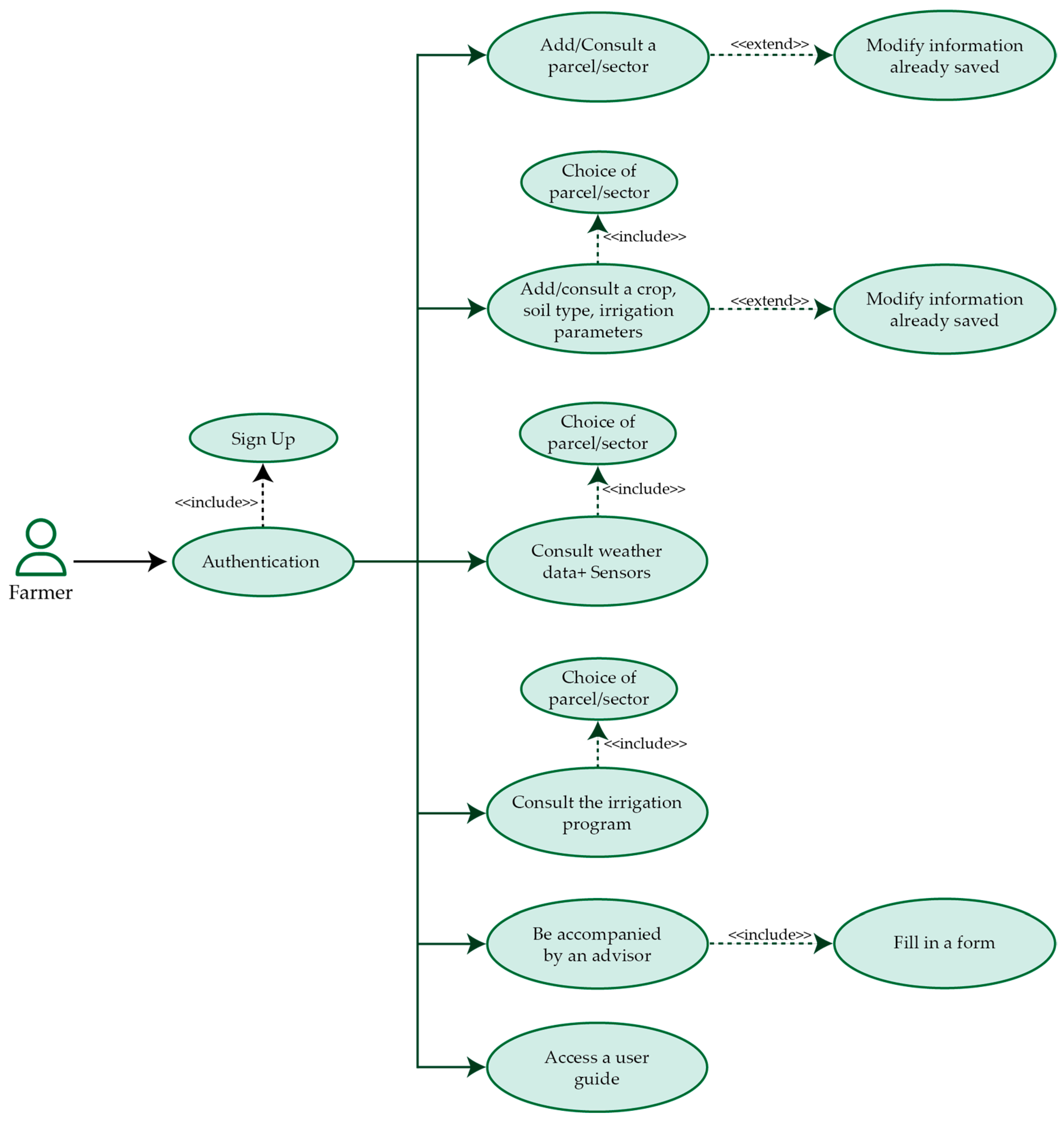
The use case diagram comprises three main elements: actors, use cases, and relationships between actors and use cases [17]. As mentioned above, in our case, there are three profiles: farmers, advisors, and decision-makers. Unified Modeling Language (UML) is used to create use case diagrams.
- (a)
- Use case of the “Farmer” profile
Figure 1 presents the farmer’s profile use case. When the farmer logs in as an operational user, he can see his profile on the platform. Detailed explanations of the functionalities can be found in the Results section.
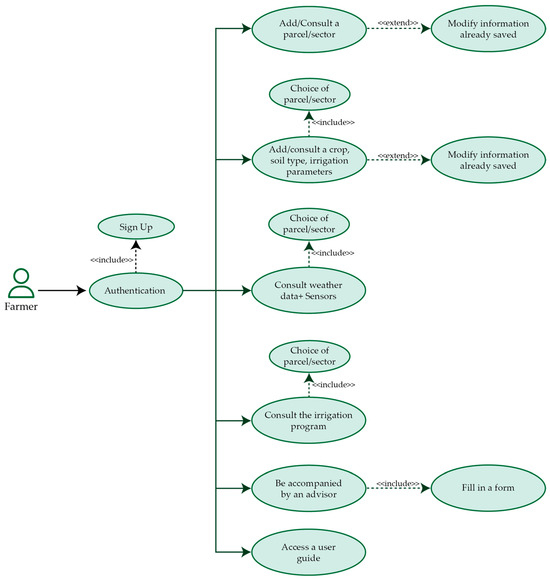
Figure 1.
Use case diagram of the “Farmer”.
- (b)
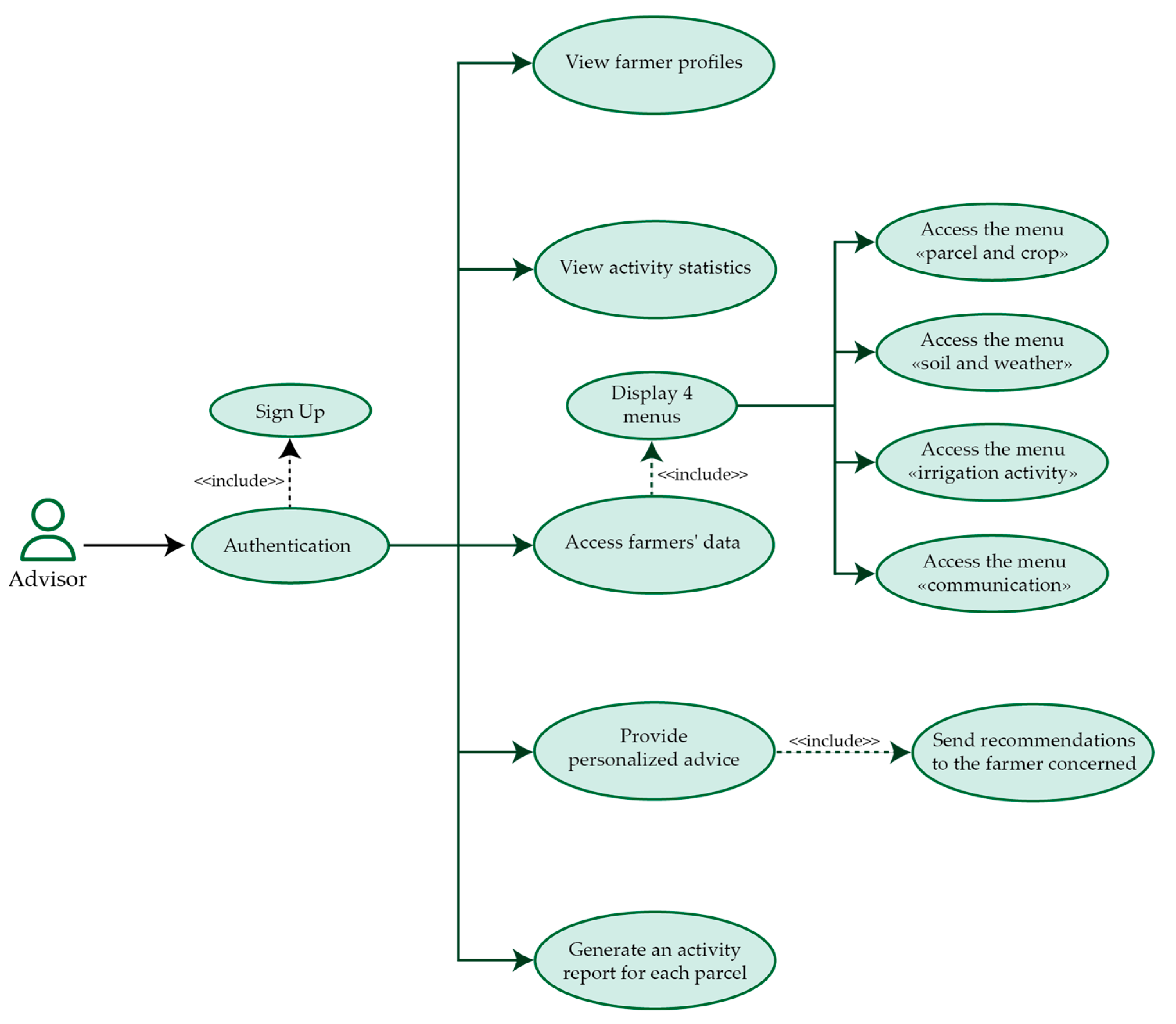
- Use case of the “Advisor” profile
Figure 2 presents the advisor’s profile use case. The advisor, being an industry expert and qualified professional, has access to a dashboard that allows him to group and visualize the farmers in his area of operation, showing their agricultural activities through graphical representations. With this tool, the advisor can view real-time data recorded by farmers on their parcels and sectors. This includes daily water consumption by crop, providing a clear understanding of the farm’s status in his geographical area.
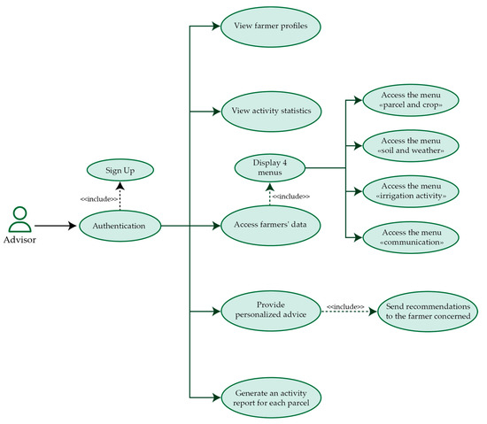
Figure 2.
Use case diagram of the “Advisor”.
Furthermore, the advisor can receive badge notifications with advanced features. For instance, if a farmer is untrained, the advisor can be notified and give special attention to ensure successful irrigation practices by tailoring recommendations and advice. Leveraging his aptitude for detailed analysis, the advisor can thoroughly supervise farmers’ actions by examining vegetation index maps in his area. This enables him to pinpoint opportunities for enhancement, identify potential issues, and intervene proactively to optimize irrigation.
- (c)
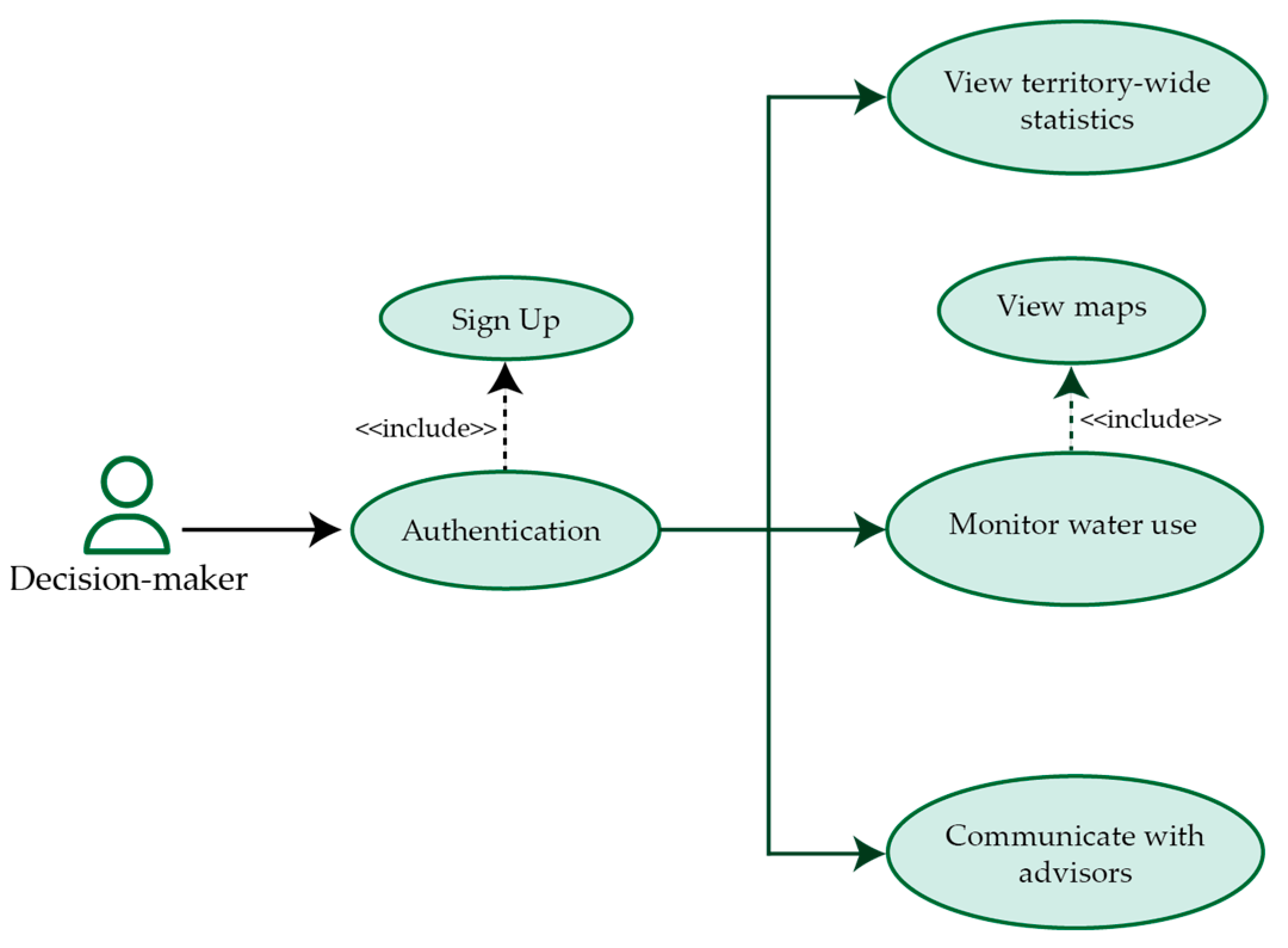
- Use case of the “Decision-maker” profile
Figure 3 presents the decision-maker’s profile use case. The decision-maker can access aggregated statistics for their region. These statistics cover various aspects such as crop yields, the region’s contribution to national production, irrigation performance indicators, and more. By visualizing these statistics, decision-makers gain an overview of the agricultural situation in their region. This empowers them to implement effective optimization measures and strategies.
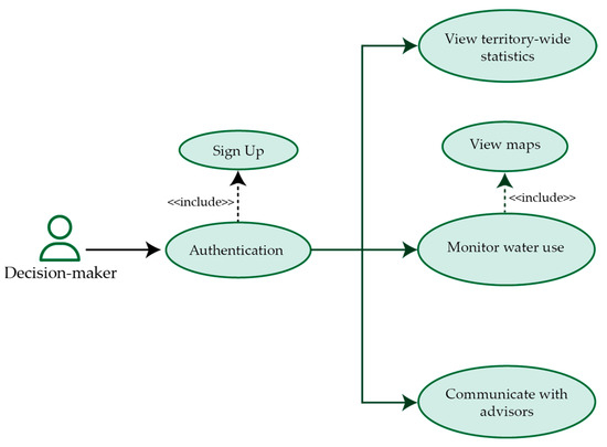
Figure 3.
Use case diagram of the “Decision-maker”.
The platform allows decision-makers to track water use in their region through a map. They can see trends by advisor sector. This helps them act promptly, namely contacting advisors in areas needing water regulation. Also, the platform helps decision-makers and advisors communicate. They can share information, such as new laws on water scarcity. This teamwork lets decision-makers use advisors’ expertise for irrigation decisions.
2.2. Architecture Design
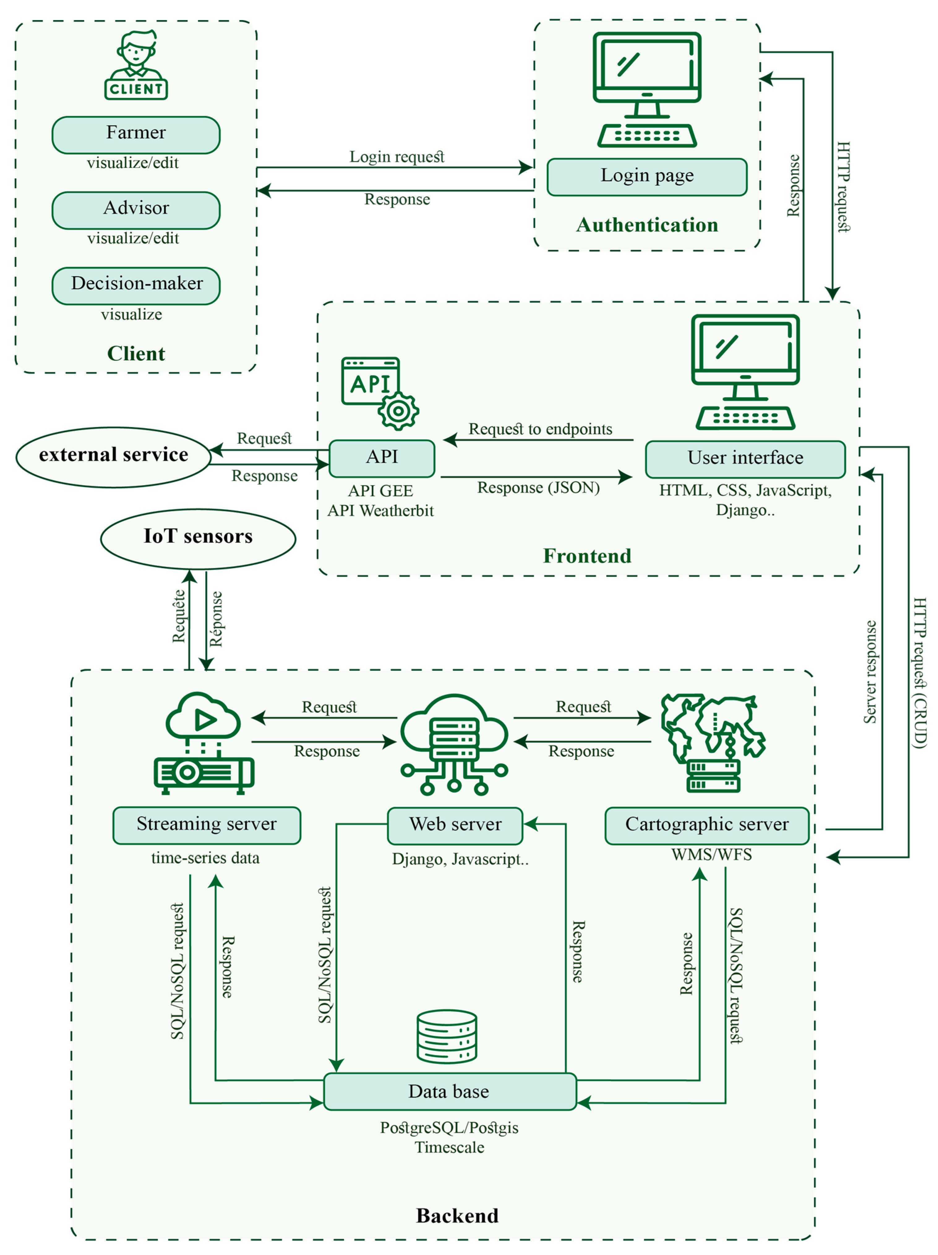
Recognizing the importance of a solid architecture from the outset for the successful completion of our project and also to avoid disruptions in subsequent development, we designed a solution offering three key modules for the management and access of the web platform. The diagram below (Figure 4) reveals our proposed dynamic architecture, in which action flows materialize between the users, the authentication page, the frontend, and the backend to provide a seamless experience.
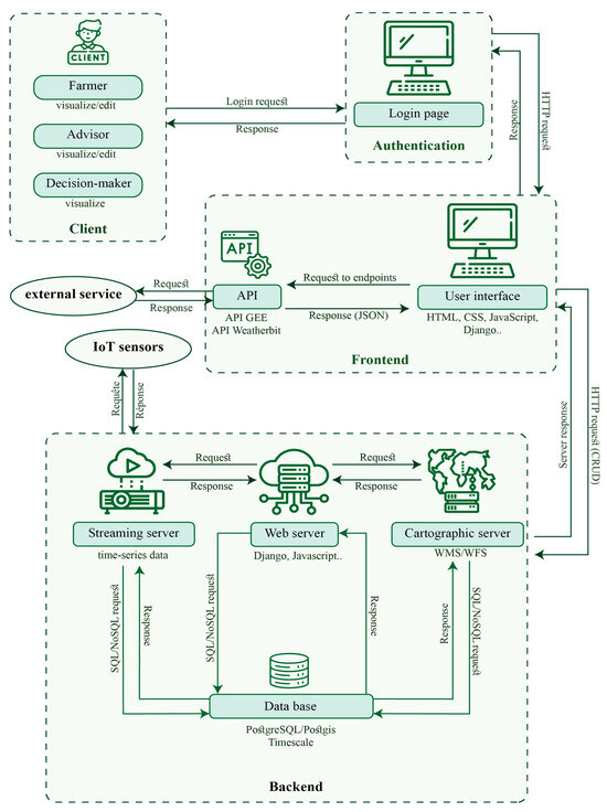
Figure 4.
Architecture of the proposed Web-GIS platform ‘Soqia-Advice’.
We will now explain each component of this architecture:
- (a)
- Client
The first component is dedicated to the end-users: farmers, advisors, and decision-makers. Each user has unique needs, and our platform is tailored to meet them.
- (b)
- Authentication
In our web application architecture, the authentication component serves as a virtual barrier, ensuring the security of our platform while making it easy for users to access front-end features. This approach ensures that only registered users can access the core functionality of the platform.
- (c)
- Frontend
The user interface enables users to interact intuitively and efficiently with the platform. Developed using robust technologies such as Django 4.2, HTML5, CSS3, and JavaScript.
Django, as a robust web development framework, provides the basic structure of our application, facilitating the efficient management of data and URL routes. HTML, CSS, and JavaScript, meanwhile, are fundamental languages that define the appearance, style, and interactivity of the user interface.
Our interface interacts with external API services such as Weatherbit and Google Earth Engine (GEE). Weatherbit offers real-time weather data, which is valuable for farmers making decisions about irrigation. Meanwhile, GEE provides vegetation index maps, allowing agricultural advisors to monitor crop conditions and offer relevant advice.
The interaction between the user interface and external API services primarily involves requests and responses. Users ask for particular information or perform actions, prompting the interface to send requests to the relevant APIs. These APIs then fetch the necessary data from external services, process it, and promptly send it back to our interface as responses.
- (d)
- Backend
The last element of our architecture contains four main parts. The web server, the map server, the streaming server, and the database. These elements are essential for managing and distributing data in real time.
The map server is used to display the maps and spatial data of our application. It enables users to create and view important geographic information, such as the boundaries of their plots or the position of ground sensors. The streaming server collects real-time information from IoT sensors in the field. This data is then processed and presented to users in graphical form. The main web server is the central point of communication. It coordinates data flows between the map server, the streaming server, and the users.
All these servers have direct access to our database. They use SQL and NoSQL queries to store new data and retrieve existing information. This ensures that data is available to users in real time while maintaining its integrity and security.
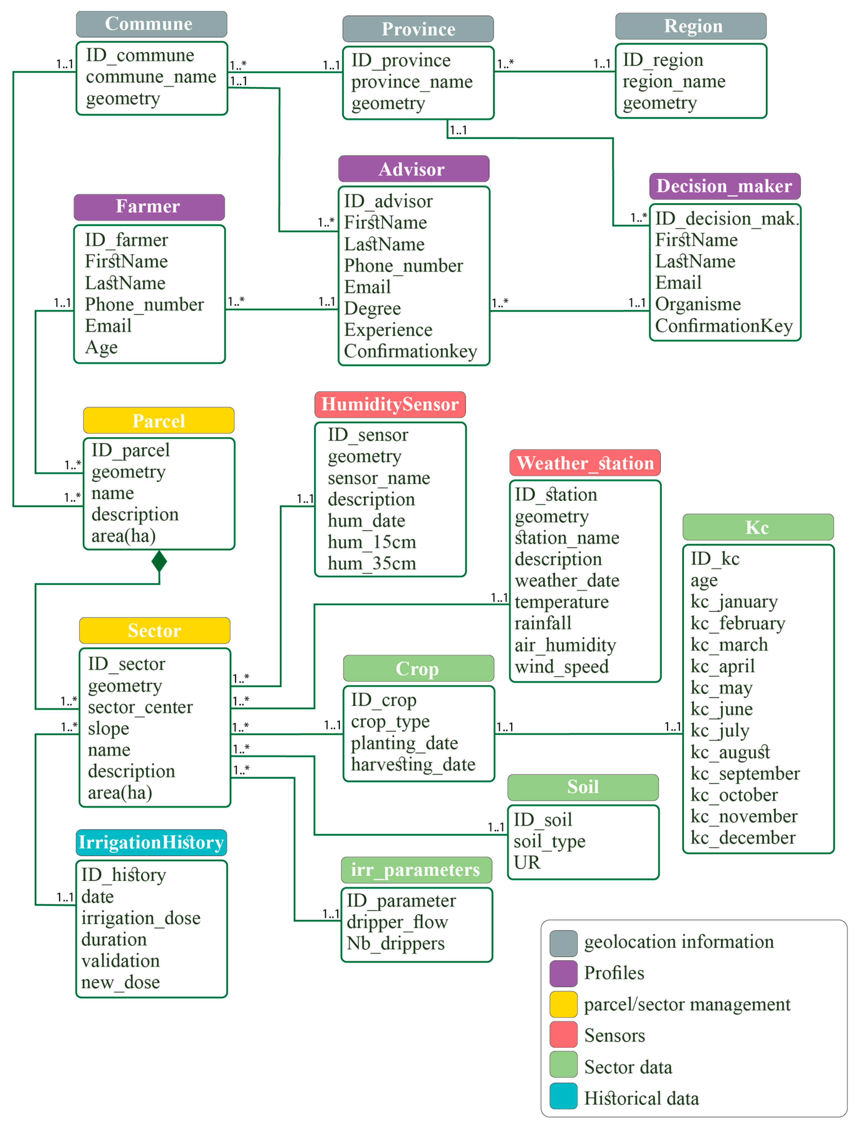
2.3. Database Conceptual Data Model
In order to meet the users’ needs and functionalities, we have to identify all the entities that will make up our database model. With this in perspective, we once again opt for the UML language, more specifically the class diagram.
In object-oriented modeling, the UML class diagram can be used to highlight certain aspects of the internal structure of a database designed to implement an application. It provides an abstract representation of the set of system objects that will interact to complete the use cases. This representation is designed by modeling the classes, attributes, and associations that animate these entities [18].
In the conceptual phase, we translated the object-oriented concepts of the class diagram to provide a suitable representation of the database that will feed our Web platform. Entities are an abstract representation of an object or a set of objects that share a common structure or behavior. Each entity has attributes that describe its properties and characteristics. Relationships reflect the links between these entities, and cardinality indicates the number of entities that can interact in a given relationship. In our model, we use the cardinalities 1..1 and 1..* to define these interactions:
1..1 (One-to-one): This cardinality indicates that each instance of an entity is related to exactly one instance of another entity, and vice versa. For example, a Crop is associated with exactly one Kc value.
1..* (One-to-Many): This cardinality indicates that each instance of an entity is related to one or more instances of another entity. For example: An Advisor can advise multiple Farmers, but each Farmer is advised by exactly one Advisor.
The abstract schema embracing these components forms the conceptual data model (CDM) illustrated in Figure 5. The mass of data to be stored, in our case, relates to the resources required for irrigation management.
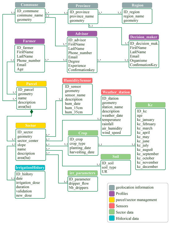
Figure 5.
Conceptual model of our web platform database.
This structuring of the conceptual model requires the creation of a data dictionary so that each heading entity or “package” can be assigned its corresponding definition. In what follows, we propose a dictionary of the entities relating to irrigation management depicted in Figure 5, organized in several packages.
- Package «Geolocation»
Region: Organize farmland according to geographical location for regional analysis and understanding of large-scale agricultural practices.
Province: Group farmland according to broader administrative divisions, facilitating analysis of province-specific farming practices.
Commune: Segment farmland according to smaller administrative divisions for a more precise understanding of local farming practices.
- Package «Profiles»
Farmer: Record information about the farmer to match water requirements to specific crops.
Advisor: Provide recommendations to farmers, helping to optimize irrigation practices according to local conditions.
Decision-maker: Inform strategic decision-making to develop irrigation management policies.
- Package «Parcel/sector management»
Parcel: The basic units where land use and productivity assessment take place to optimize irrigation and yields.
Sector: The parcel entity where similar characteristics exist: same crop, same soil type, same irrigation equipment.
- Package «Sensors»
Humidity-sensor: Provides real-time information on soil water requirements for targeted irrigation.
Weather-station: Provides real-time weather data when making irrigation decisions, ensuring optimum use of water.
- Package «Sector data»
Crop: Monitor the types of arboriculture grown on farmland, understanding their water consumption.
Soil: Provide information on soil characteristics to understand fertility conditions and adapt cropping practices.
Irrigation parameters: Provide localized irrigation system parameters to optimize water resources.
Kc: crop coefficient that quantifies a crop’s water demand at a given moment in relation to its maximum water demand.
- Package «History»
Irrigation history: Store past irrigation data to facilitate analysis of past practices.
In the conceptual model of the irrigation management database, the classes defined in the “Geolocation”, “Profiles”, “Plot/Sector Management”, “Sensors”, “Sector Data” and “History” packages lay the foundations for a complete system. To exemplify the interconnections between these classes, a few key relationships have been introduced.
Firstly, a one-to-many relationship exists between the “Crop” table and the “Sector” table. This implies that a specific crop type can be cultivated in one or more sectors, facilitating a nuanced analysis of crop distribution patterns and their influence on irrigation practices within distinct agricultural areas.
Furthermore, an aggregation relationship is defined between the “Parcel” table and the “Sector” table, denoting that multiple sectors collectively form a parcel. This structural arrangement enables a hierarchical representation of the farmland, supporting detailed assessments of land use and productivity within larger spatial units.
Finally, a one-to-one relationship is outlined between the “Crop” table and the “Kc” table. This signifies that each crop type corresponds to a specific table of crop coefficients (Kc) that quantifies its water demand at a given moment relative to its maximum water demand. This precise association aids in tailoring irrigation practices to the specific needs of each crop type.
In conclusion, these well-defined relationships seamlessly integrate with the previously outlined entities, collectively forming a robust database model for irrigation management. This intricate network of connections enhances the system’s ability to capture and analyze the complex interdependencies within the agricultural landscape, providing valuable insights for informed decision-making and strategic planning in irrigation management policies.
2.4. Crop Water Requirements
The crop water requirements are estimated through the calculation of crop evapotranspiration (ETm), derived from reference evapotranspiration (ET0), multiplied by the corresponding crop coefficient (Kc) (1) [19].
where ET0 (mm) is the reference evapotranspiration, computed in real-time using the simplified Penman Equation (2), which incorporates maximum and minimum temperatures, Tmax (°C) and Tmin (°C), and humidity data, RH (%) [20].
where T = (Tmax + Tmin)/2 denotes the average temperature (°C), and Ra stands for extraterrestrial radiation (MJ/m2/day).
ETm (mm)= ET0 (mm) × Kc,
Monthly Kc values for the crops targeted by our platform are stored in the database. Subsequently, we computed the Net Irrigation Requirements (Net-r), by substracting the effective rainfall (Er) of the day from the crop evapotranspiration (ETm) [21].
Net-r (mm)= ETm (mm) − Er(mm),
The irrigation volume can then be obtained by multiplying the Net Irrigation requirements by the area of the sector.
3. Implementation
3.1. Study Area
The study area (Figure 6) is a farm located in the province of Azrou, a Moroccan city situated 18 km southwest of Ifrane. Azrou, a semi-arid region, experiences a warm and temperate climate, characterized by significant precipitation in winter. As severe droughts were reported in the last decades in Morocco, semi-arid areas were affected due to high precipitation variability and insufficient water storage, with intensely cold winters and hot summers [22]. According to the Köppen-Geiger classification, the prevailing climate in this region is classified as Csa. Azrou maintains an average annual temperature of 12.1 °C, with approximately 664 mm of precipitation annually [23]. The farm spans a total area of 5.4 hectares and is divided into four growing sectors, each designated for specific varieties of apple and pear trees.
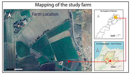
Figure 6.
Map of the study area—Azrou agricultural farm.
The farm is equipped with a drip irrigation system and two soil moisture sensors at depths of 15 cm and 30 cm. These sensor data feed the “Agzoom” platform and can be downloaded according to the date range desired by the user.
3.2. Used Technologies
3.2.1. Framework and Programming Language
In today’s competitive digital world, developers are constantly on the lookout for application development frameworks or tools to facilitate their work. The advent of technology has given rise to the framework, a coherent set of structuring software components dedicated to establishing the guidelines of an application. Equipped with their own file architecture, which must be followed throughout the development process, these frameworks make it possible to set up an application by carrying out a series of operations in a simplified way, thanks to methods previously designed within their libraries. These systems, which have become essential conceptual frameworks today, provide a ready-to-use infrastructure and are widely adopted by industry professionals.
We chose Django for our irrigation advisory platform for arboriculture. This choice was based on an appreciation of both its architectural and functional advantages. First and foremost, its model-template-view (MTV)-based architecture resonates perfectly with the technical architecture planned for our application. Django’s ability to clearly separate the business logic, the user interface, and the corresponding data is on the same wavelength as our objective: to offer an irrigation consulting platform that systematically manages data relating to plots, crops, and water requirements. Moreover, this allows us to organize the various menus on our platform in harmony. Secondly, Django is intrinsically compatible with our database management needs. Its object-relational model (ORM) will facilitate interaction with the project’s relational database, facilitating integration of the proposed classes into the platform’s source code while maintaining data consistency over time. Finally, the power of Python as a development language resonates well with our project. The processing capabilities and tools for managing geospatial data, notably Django’s geospatial extension “GeoDjango”, are crucial for our platform.
3.2.2. Database Management System
As our model design is based on tables, attributes, and cardinalities, it makes sense to adopt a relational database management system (RDBMS) to store the data flow. The major current solutions compatible with Django are Oracle, MySQL 8.0, and PostgreSQL 15.3 for a Web application.
After careful consideration of our needs and the functionalities offered by different solutions, we decided to use PostgreSQL because it offers significant advantages, including its advanced ability to efficiently manage geospatial data, making it perfectly suited to our specific project. In addition, another criterion that weighed heavily in our choice was cost. PostgreSQL is an open-source system, and the spatial extension PostGIS 3.4 is a free solution.
3.3. Functionality Development
The functionalities we are about to present are the result of the previous phases of the project, in particular the needs analysis, during which we associated specific functionalities with each identified need. The result of our work is the development of two applications. The first is dedicated to authentication, and the second to irrigation advice.
3.3.1. Authentication Application
The application provides both login and registration, grouped under the general term of authentication system. To associate content with its creator, we ask each user to select a profile: farmer, advisor, or decision-maker. For illustration, we focus on the farmer’s profile, which implies that certain key attributes are mandatory for account creation (Figure 7), including: username, password, first name, last name, email, age, and phone number.
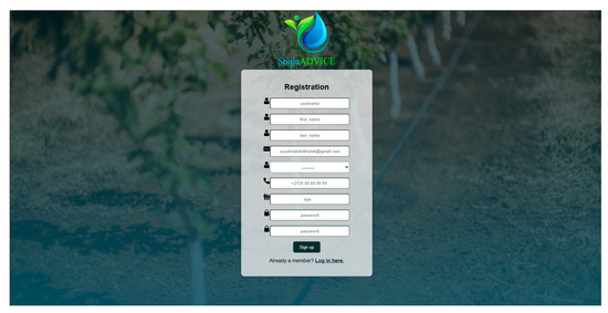
Figure 7.
Presentation of the platform registration interface.
3.3.2. Irrigation Advisory Application
Once authenticated, the farmer accesses the project’s second application, giving him access to functionalities designed to provide irrigation advice. This is performed via the menus available in the solution. These menus are described in the following sections:
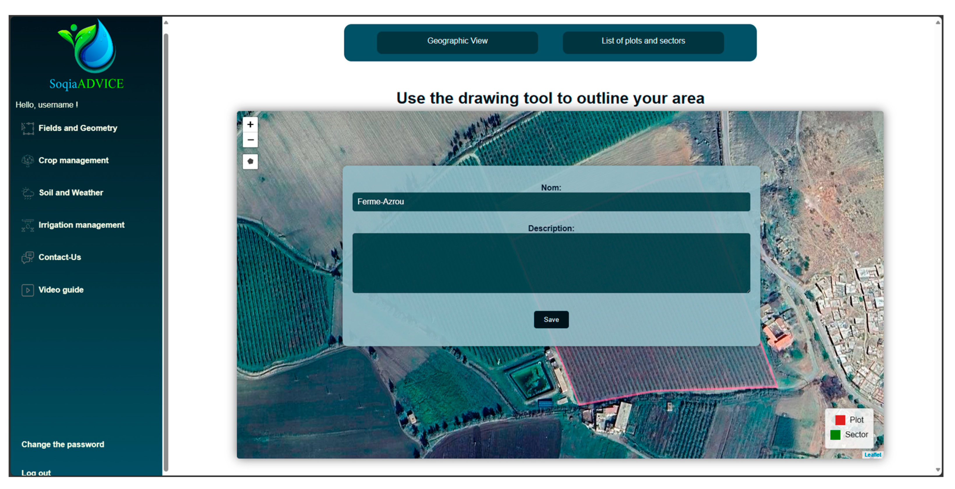
Menu 1: Fields and Geometry
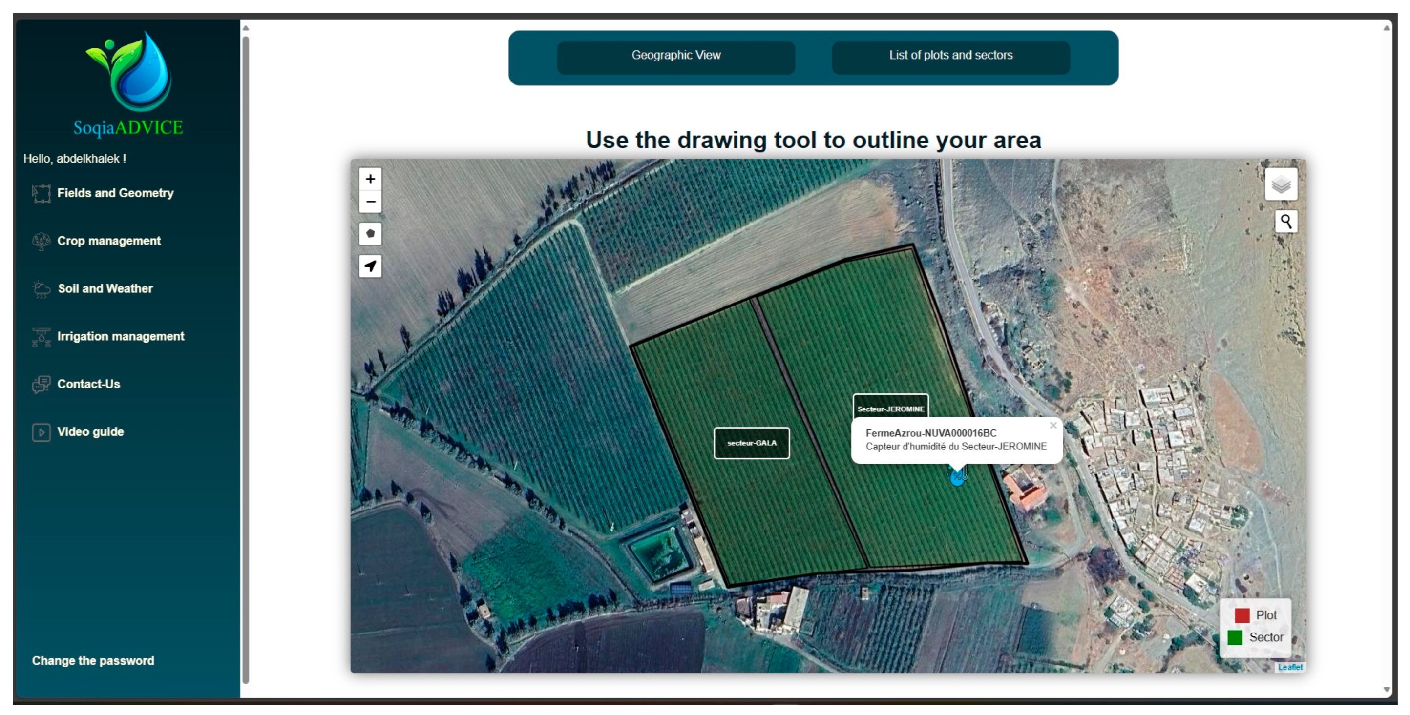
Once authentication has been successfully completed, the user, in this case the farmer, accesses the “Fields and Geometry” menu. This menu features a “Geographical View” button for an interactive map interface powered by the leaflet library. This map enables the farmer to perform two main actions: add new agricultural parcels and view existing parcels with device markers. There is also the geolocation tool, which allows users to determine their exact location on the map, an intuitive alternative to help farmers position themselves on the map and draw the boundaries of their parcels. The following screenshot (Figure 8) shows the map displayed when the ‘Geographical view’ button is clicked.
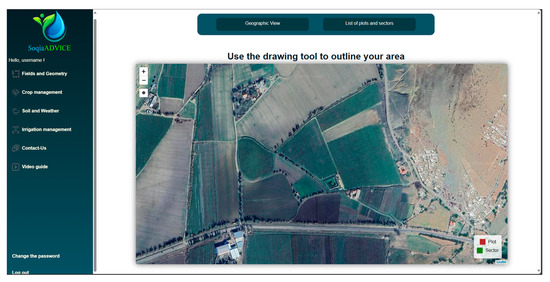
Figure 8.
Displaying the contents of the ‘Geographical view’ button.
The polygon drawing tool available on the map allows the farmer to create new parcels and define their boundaries on the map. Then, a contextual form is displayed, requesting the necessary information from the farmer, such as the name and description of the plot. This data is then stored in the database. Figure 9 illustrates the form fields to be filled in to register a plot.
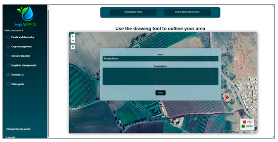
Figure 9.
Descriptive form to be completed for the delimited parcel.
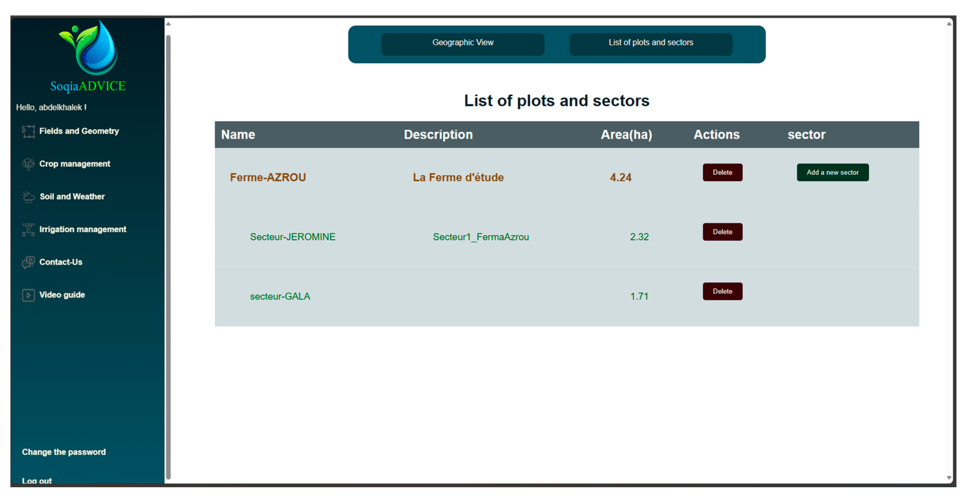
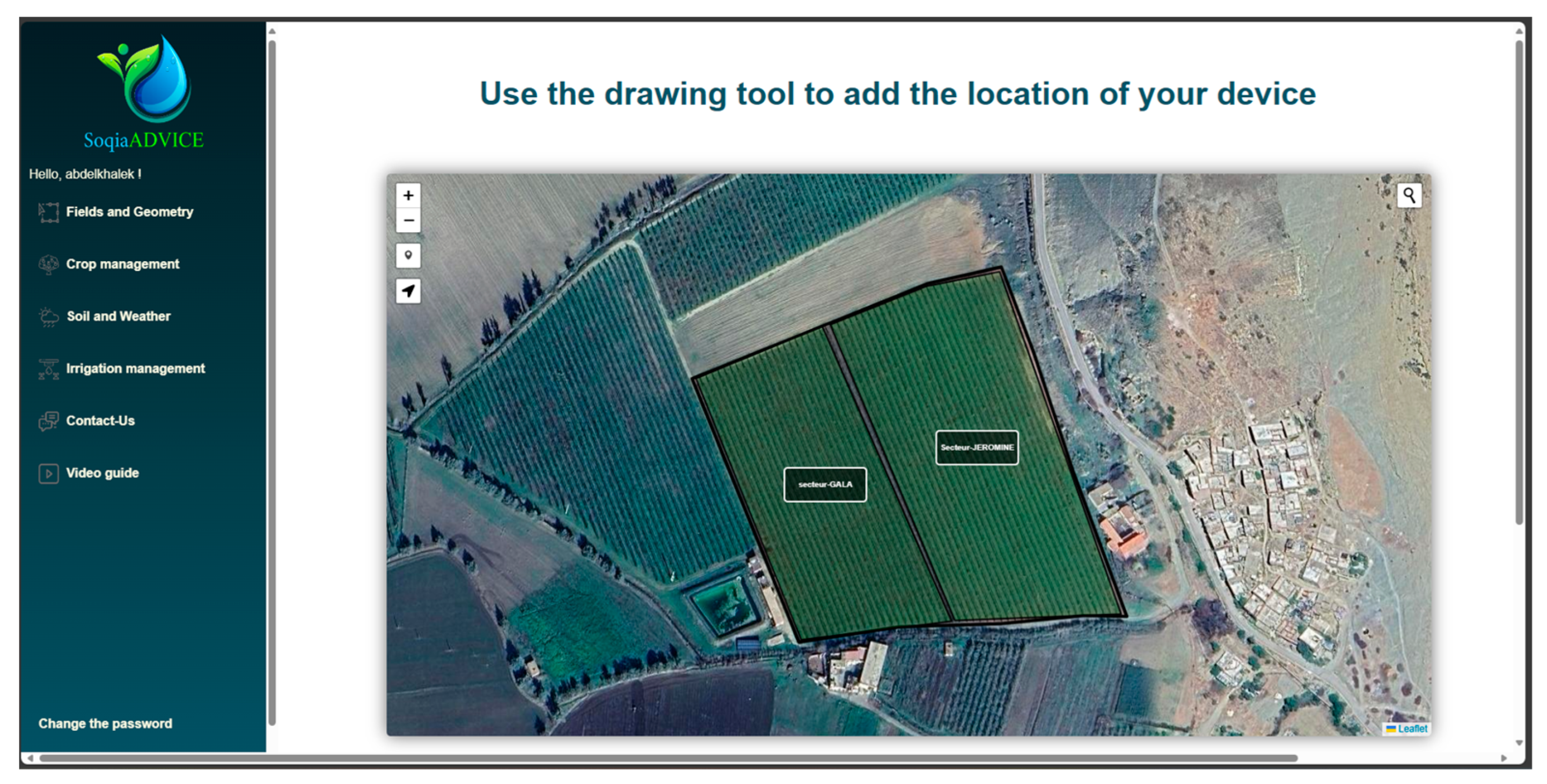
The second menu button, entitled “List of plots and sectors”, shows a detailed list of all registered parcels and information associated with them. This display mode also allows the farmer to delete a parcel or add a sector to an existing parcel. The sector is a specific portion of the parcel. The process for adding a sector is similar to that for creating a new parcel. Figure 10 and Figure 11, respectively, show the table containing the farmer’s parcel and sector registrations, and the registration of their geometries on the map (Plot in red, and Sector in green).
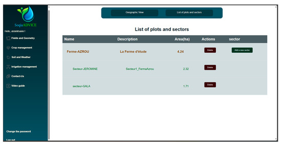
Figure 10.
Display a list of registered plots and their corresponding sectors.
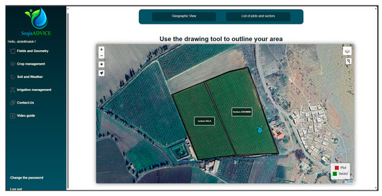
Figure 11.
Display of parcels and sectors on the leaflet’s geographical background (Plot in red and Sector in green).
Menu 2: Crop Management
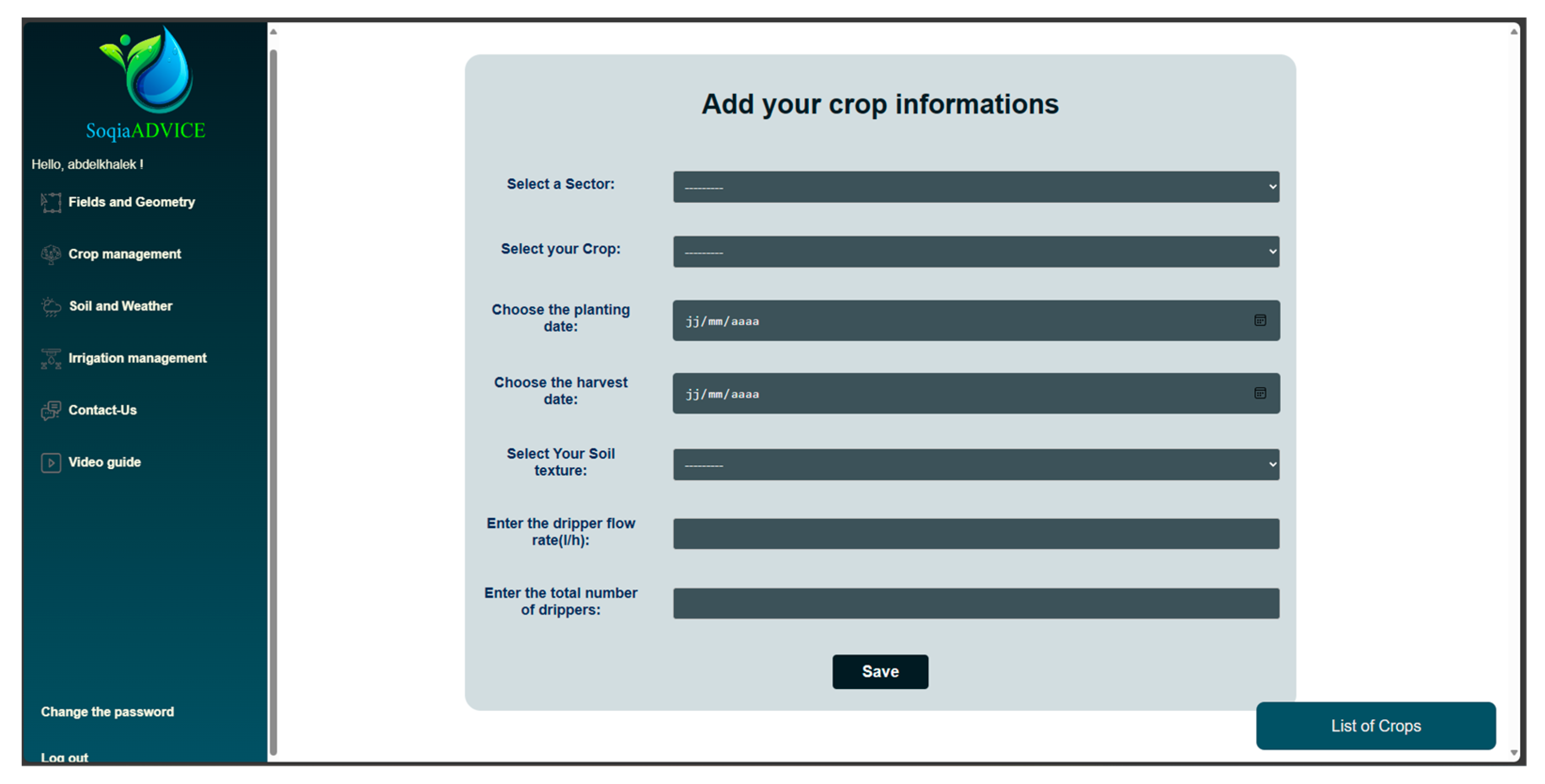
In the “Crop Management” menu, the farmer can fill out the form illustrated below (Figure 12), so as to assign each sector a specific crop, a particular soil type, and a defined irrigation system. It should be noted that the list of crops used is specifically focused on tree crops, in line with the platform’s orientation.
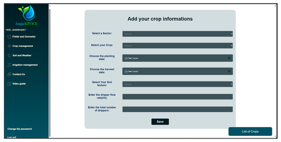
Figure 12.
The information to be provided is in the form of the second menu, “crop management”.
The farmer is also asked to provide other information, such as the date the tree was planted and when the fruit is expected to be harvested. These details are essential for planning and monitoring the irrigation of tree crops. Localized irrigation parameters are also requested, such as the flow rate and number of drippers present in the area.
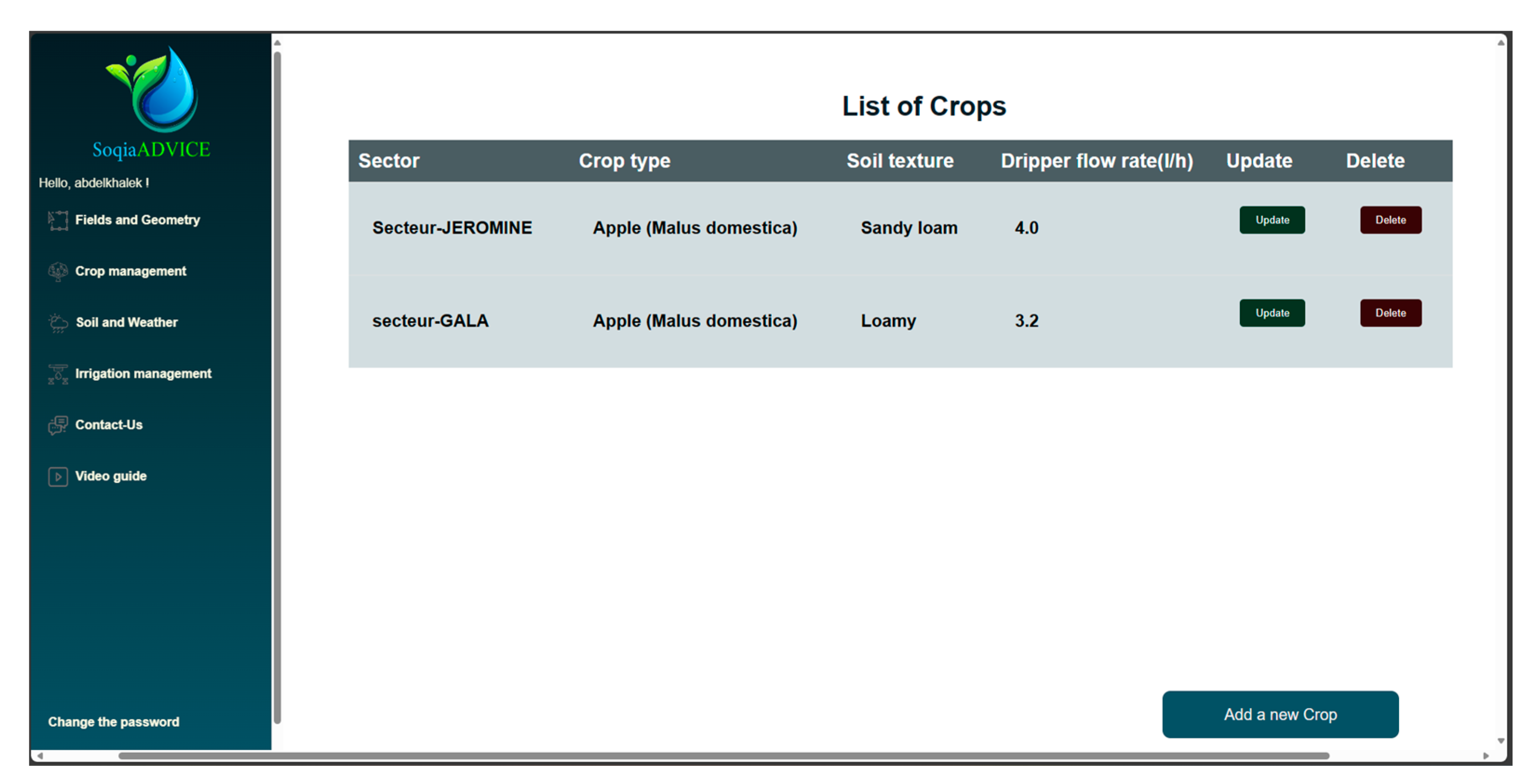
In the ‘List of Crops’ button, a table displays the records resulting from the form. The user can modify the basic parameters previously entered for each crop, or completely delete the corresponding record via the ‘Update’ and ‘Delete’ buttons, respectively (Figure 13).

Figure 13.
Display of the crop list registered using the form.
Menu 3: Soil and Weather
This menu combines two data sources: weather forecasts provided by the Weatherbit API or the local weather station and soil moisture measurements captured by two IoT sensors positioned in the farm at depths of 15 cm and 30 cm.
Providing real-time access to weather forecasts, the Weatherbit API gathers live weather data from over 50,000 weather stations and benefits from historical information covering the last 20 years. Data is collected from operating weather stations, Doppler radars, orbiting satellites, and atmospheric reanalysis products [24]. This source of information guarantees accurate weather monitoring.
The weather forecasts provided cover a 7-day period (Figure 14) and include the parameters essential for calculating the irrigation dose, such as temperature, precipitation, wind speed, and relative humidity.
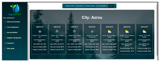
Figure 14.
Weather forecast for the next 7 days.
This menu also presents soil moisture data collected via IoT sensors positioned on the Azrou farm. These sensors measure soil moisture at two different depths, 15 cm and 30 cm below the soil surface. Access to these data is established by connection to the “Agzoom” platform, which is then stored in the “HumiditySensors” table of the database. The results are presented in graphical form (Figure 15).
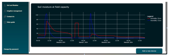
Figure 15.
Graphs showing soil moisture at two depths.
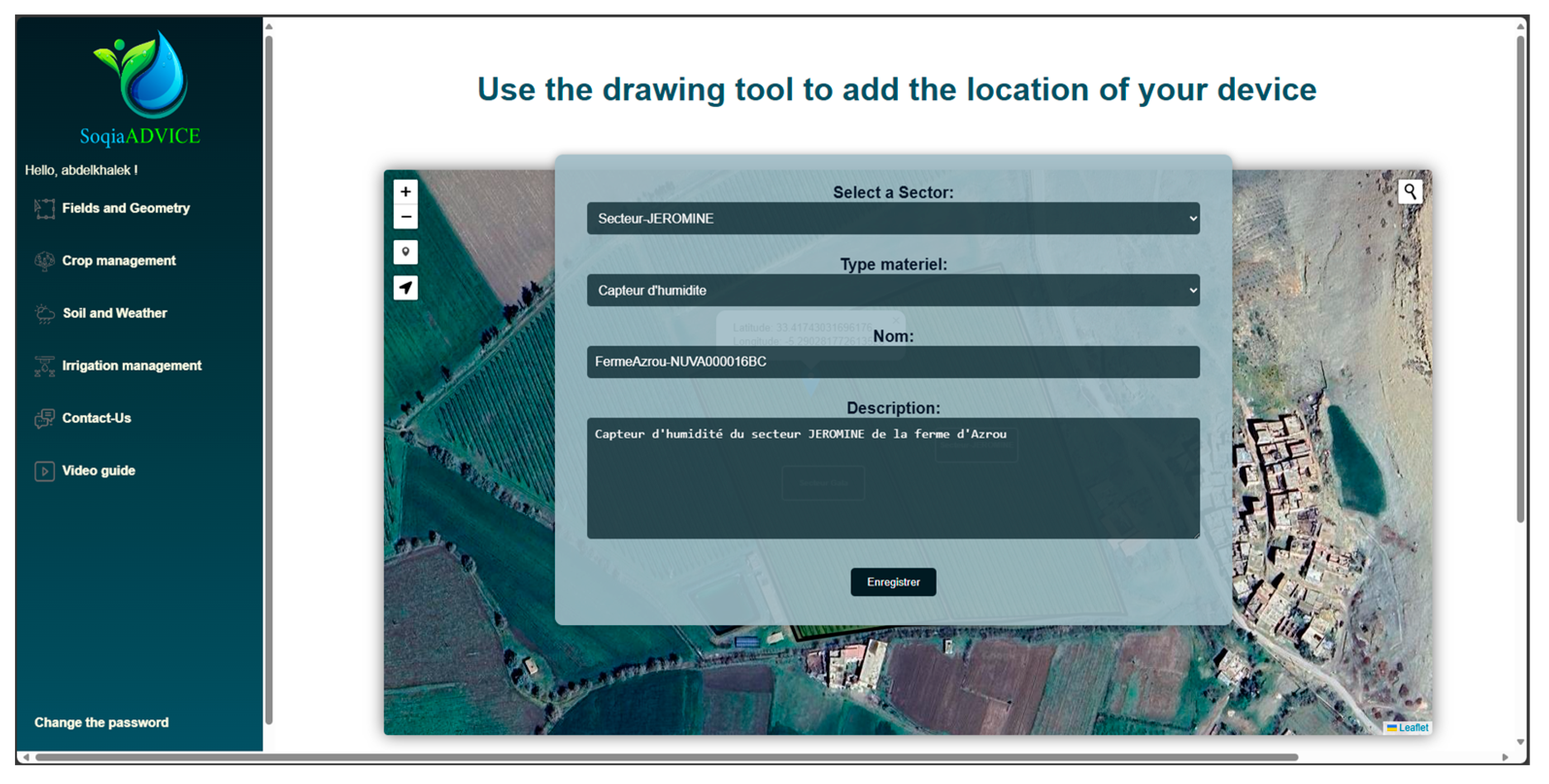
Selecting the “Add a new device” button at the bottom right gives the farmer the option of registering any new equipment or devices in his plots or sectors. A map view is displayed showing his plots and sectors, offering the user a pointing drawing tool to place the cursor at the desired location of the new equipment on the map. In Figure 16, we can see the display of the farmer’s parcels and sector geometries for pointing purposes.
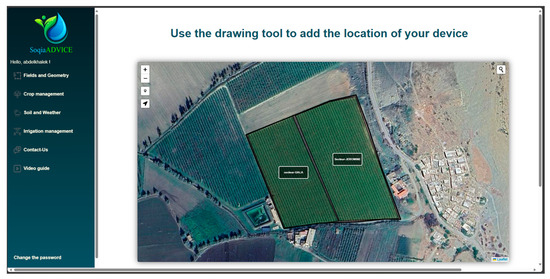
Figure 16.
Pointing tool for a new device on the map.
The farmer can then enter the corresponding name and description to identify and document this new equipment; see the form in Figure 17.

Figure 17.
New device labeling form.
The added device is also displayed in the “Geographical view” of the first menu, “Fields and Geometry”, as shown in Figure 18, providing an overview of the parameters saved by the farmer during future login sessions.

Figure 18.
Display of added devices in “Geographical view”.
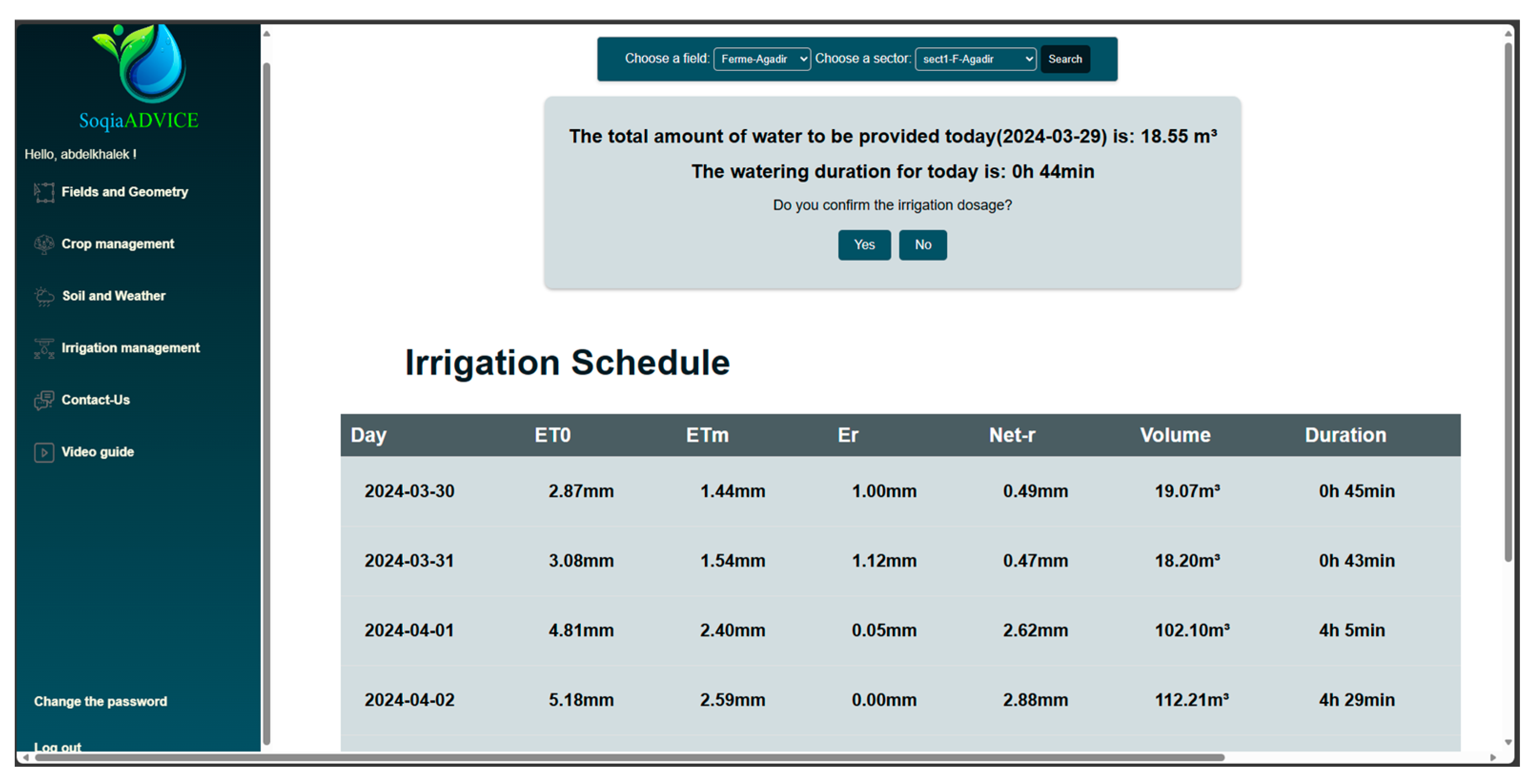
Menu 4: Irrigation Management
At the final stage of our platform, we present the irrigation management menu. This section aims to provide the farmer with the recommended daily irrigation dose and duration for the selected crop. As well as, involving the farmer in the decision-making process, we’ve added “Yes/No” buttons to prompt the farmer to confirm the irrigation dose proposed by our platform. If he clicks on the “No” button, he will be able to enter a new dose. All data (proposed by the platform or entered by the farmer) will then be saved in the database. Figure 19 shows the components of the “Irrigation management” menu.
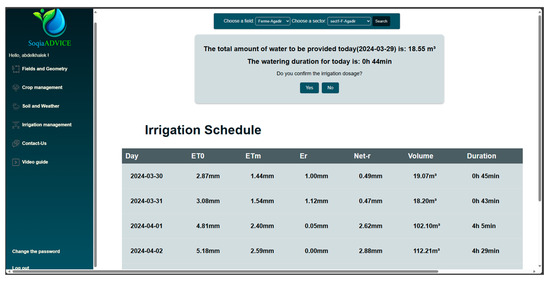
Figure 19.
Display of daily dose and duration in the “irrigation management” menu.
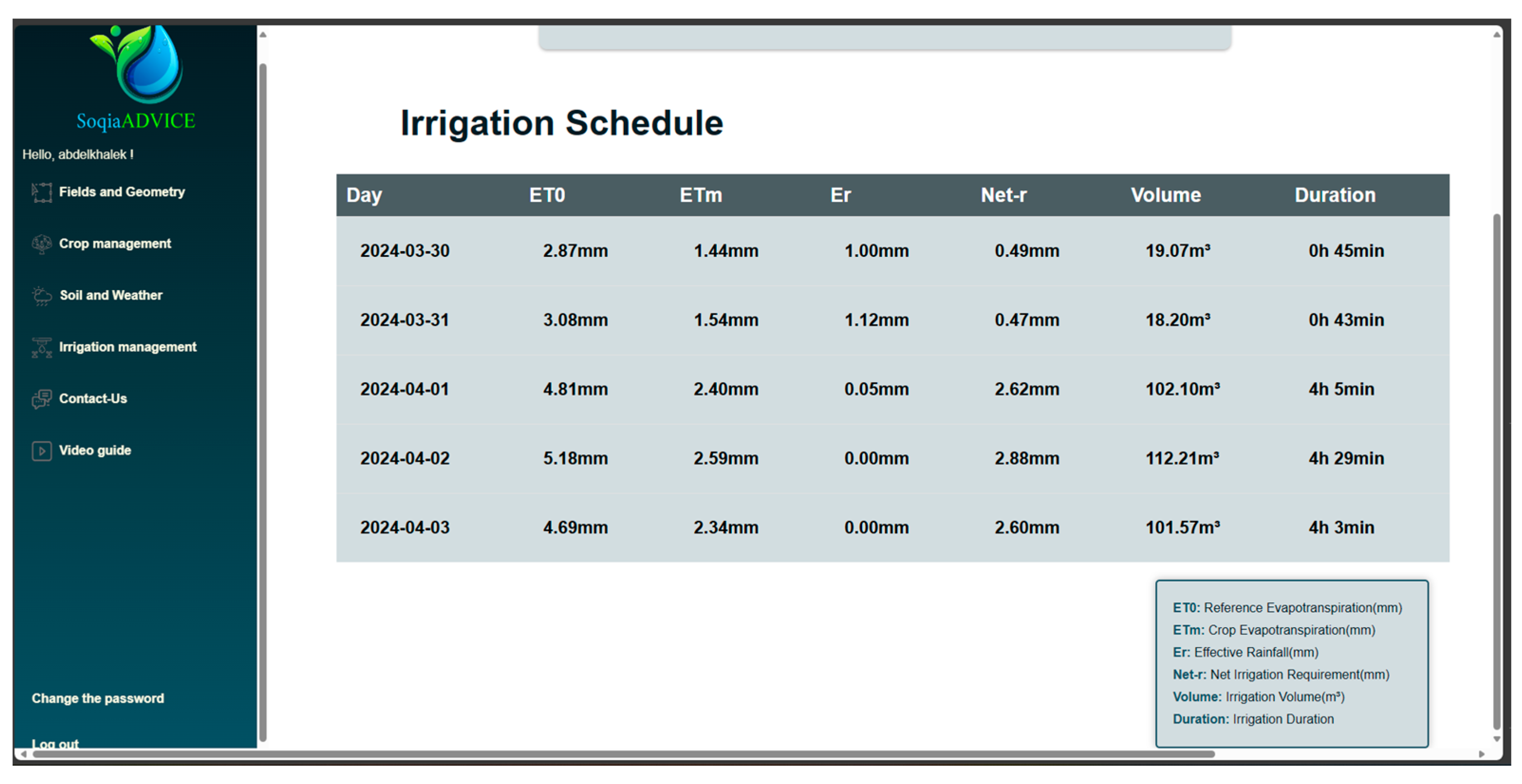
The main objective of this menu is also to provide an irrigation schedule spread over five days to follow the daily advice (Figure 20), based on weather forecasts obtained through the Weatherbit API. These forecasts enable us to estimate the reference evapotranspiration (ETo) using the Penman-Monteith relationship simplified [20].

Figure 20.
Display of the irrigation schedule spread over the next 5 days.
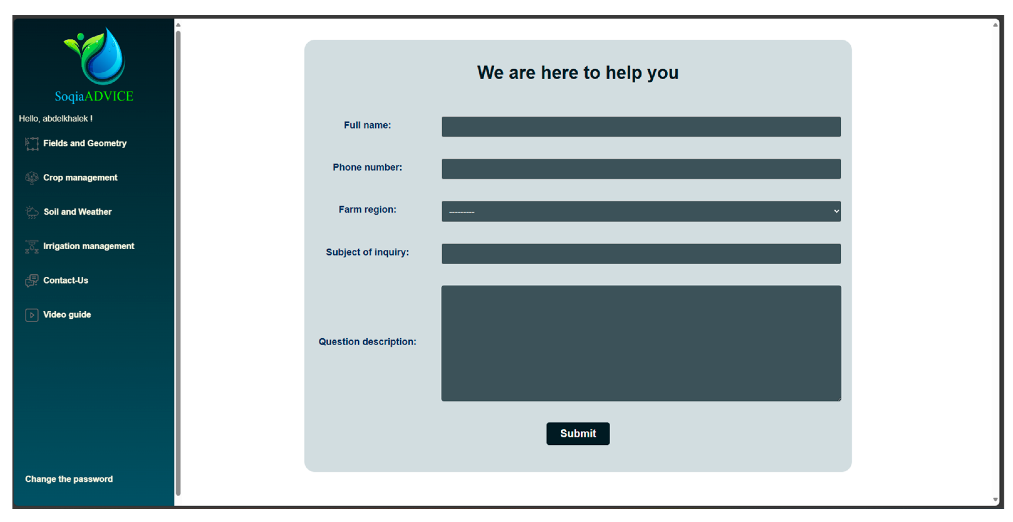
Menu 5: Contact-Us
The support menu, available in the farmer’s profile, is an essential element of the platform. It has been designed to simplify the process of communicating with advisors, aiding less educated farmers in maximizing the benefits of our platform. The aim is also to respond quickly and efficiently to the farmer’s needs for assistance and support in the following ways:
- Request for technical assistance?
- Need further information?
- Report an anomaly?
The following figure (Figure 21) shows the form fields to be filled in.
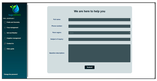
Figure 21.
Form to fill in to be accompanied by an advisor.
3.4. Functionality Tests
Functionality testing plays an essential role in assessing the performance and robustness of our application. They help to ensure that all planned functionality works smoothly and reliably, thus meeting the needs of farmers. In this section, we describe the various feature tests we have undertaken in the study area to ensure that our application offers an optimal user experience and fully operational functionality.
3.4.1. Authentication
The authentication test was successfully completed, demonstrating that the application’s registration and login functionality are working correctly. When creating accounts, user data is stored in the database, ensuring that each user has a unique profile. A notable feature is the implementation of a data filtering mechanism based on the user who created it. This means that data entered by one user cannot be accessed by others. This access control feature guarantees data confidentiality and reinforces application security by preventing unauthorized access to sensitive information.
3.4.2. Parcel/Sector Creation
The parcel and sector creation test was successful, confirming the functionality of this feature. Parcel creation was facilitated using the leaflet-based interactive map, allowing users to precisely define their agricultural parcels. All parcel-related data was appropriately stored in the database, ensuring data preservation and accessibility.
Once a parcel has been created, it is displayed in the parcel list with its attribute information and buttons enabling the user to edit sectors within it. The process for creating sectors within a parcel is intuitive and similar to that for creating parcels, simplifying sector management.
3.4.3. Crop Management
The crop management test involved accessing the corresponding form, where the first step is to select the sector to which specific information will be assigned, such as crop type, soil texture, and dripper flow rate. Once the form had been completed, this information was recorded in its appropriate classes and linked to the selected sector ID.
On the crop list page, the information is displayed systematically, with each sector accompanied by its associated details. This approach enables efficient management of crop data for each specific sector, making it easier to monitor and plan farming activities according to the individual needs of each area.
3.4.4. Weather Data
The test of the weather forecast data was carried out by first delimiting two plots with distinct sectors, one in Tangier and the other in Azrou, two cities with different climates. The application displayed the weather forecasts specific to each area. To display a weather forecast, the user must select the corresponding plot. One can only view the weather forecasts for the sectors they have previously created.
3.4.5. Irrigation Management
Irrigation management tests were carried out in depth and showed positive results. When selecting a specific area to display irrigation advice, the application generated the irrigation advice in the form of a message, providing the irrigation dose and duration for the current day. In addition, an irrigation schedule table for the next five days was displayed, enabling farmers to plan their irrigation activities in advance.
An important test was to display the irrigation schedule for periods when there was rainfall in Azrou. It was confirmed that meteorological data, including rainfall, were taken into account when calculating the irrigation dose, thus ensuring efficient water use in line with actual climatic conditions.
4. Discussion
Through this case study, we were able to demonstrate the potential of the proposed approach for obtaining informed advice on irrigation water management for arboriculture. The results obtained following the application of the approach are quite conclusive and very convincing.
The first objective of this study was to develop a solid conceptual approach for our platform by accurately identifying the needs and stakeholders involved. To this end, we carried out a meticulous analysis to determine the key players who would interact with our web platform. These key players were identified as the farmer, the irrigation advisor, and the decision-maker, each playing a distinct and essential role in the irrigation advisory and water resource management processes.
We also specified the type of crop we were targeting, namely arboriculture, as well as the irrigation system that would be used, in this case, the drip system. This precision in defining our platform’s context of use was important to guaranteeing its real utility for our target users.
To better understand the functional needs of each stakeholder, we undertook an in-depth analysis. This analysis enabled us to define in detail the essential actions and functionalities expected of each player in the irrigation management process. These functional requirements were then recorded in use-case diagrams for clear visualization.
The next objective of our project was to design the technical architecture of the solution, to guarantee the robustness of the functionalities set out in our irrigation consulting platform. Our approach was guided by the concern to create an architecture capable of meeting the needs of our users, in particular the farmer, the module deemed to have priority. The menus for this profile were carefully selected according to the needs identified during our conceptual study. Their development was carried out in a methodical and structured way and was put into practice on the Azrou farm.
Our irrigation advisory platform offers a series of considerable advantages for the selected profiles, particularly farmers. The functionality tests we have carried out have confirmed the robustness of our solution.
What’s more, the authentication function has proven to be robust and secure. This means that user data is well protected, and each user has a unique profile. Our access control mechanism ensures that information remains private, further reinforcing the security of the entire application.
Our solution also succeeded in significantly resolving the issues mentioned at the outset. Firstly, we have helped to overcome the lack of digital irrigation platforms in Morocco by proposing an innovative solution in this sense, which fills the gap in the provision of digital irrigation advice through the use of the latest technological advances, satellite imagery, and IoT sensors.
Secondly, our platform is designed to take into account the potential of arboriculture in Morocco. We have developed specific functionalities for this strategic crop, enabling us to optimize the productivity and sustainability of arboriculture.
Thirdly, we have adopted an inclusive approach to the design of our platform. Unlike some platforms that target farmers exclusively, our platform integrates all stakeholders involved in the irrigation sector. Farmers, irrigation advisors, and local decision-makers all have access to our platform, which promotes a more holistic and participatory management of water resources.
Compared with existing platforms such as OSIRI and FIVE-CoRe [25], MABIA-Exploitation [26], FIGARO [27], and the initiatives of the Euro-Mediterranean DATI project [28], our platform presents a limitation when it comes to calculating the irrigation dose. Whereas previous efforts have focused on specific aspects such as climate estimation, soil water reserve assessment, or precision irrigation using crop growth models and sensor data, our platform relies solely on weather forecasts and crop coefficient values to estimate crop water requirements.
Moreover, initiatives such as WaterSmartGIS [29] and Irriman [30] highlight the importance of real-time data collection and geospatial technologies in irrigation planning. Our platform builds on these principles by leveraging IoT sensors to provide timely and accurate advice on irrigation water management, as well as a planned use of satellite imagery in the future development of this project.
Furthermore, professional platforms utilizing satellite remote sensing, such as IRRISAT and EO4WATER [21], offer valuable insights into crop water requirements. However, they are not freely accessible to farmers and require subscriptions that can be costly for small-scale agriculturalists. In contrast, our platform endeavors to address this issue by providing a free and user-friendly interface, along with personalized advice, ensuring accessibility and affordability for all farmers, regardless of their scale of operation.
Finally, platforms such as Spark Irrigation System [31] and Arvum [32], which heavily rely on ground-plant sensors, may present a limitation for small-scale farmers who lack access to such technology in their regions. This is why we have developed a module that does not necessarily depend on sensors and can generate irrigation advice based solely on meteorological forecasts for the area, coupled with the crop coefficient.
Looking at the potential socio-economic impact of our platform on target users, it is clear that our solution could be very promising. By enabling farmers to access personalized irrigation management advice, we aim to improve productivity, optimize resource use, and, ultimately, improve economic outcomes for stakeholders in the arboriculture sector. Furthermore, the versatility of our platform paves the way for expanding our service offering beyond irrigation management.
Looking towards the long-term vision for the development and expansion of our platform, we are committed to integrating geospatial technologies into precision irrigation practices in Morocco. This initiative aligns with a larger-scale project aimed at revolutionizing agricultural practices through advanced technological solutions. Within this framework, ongoing efforts involve the development of deep learning and machine learning models for soil moisture estimation, fruit tree yield prediction, and phenological stage detection using satellite imagery. By leveraging these cutting-edge techniques, our platform aspires to become a cornerstone in the transformation of agricultural landscapes, fostering sustainability, resilience, and innovation in irrigation practices across Morocco.
In conclusion, it is important to recognize that this project represents a major step forward in the field of agricultural irrigation management. The platform developed offers considerable potential for improving irrigation efficiency. However, its ultimate success depends on its adoption by farmers, as well as on ongoing training and appropriate technical support. Perseverance in improving the platform in response to evolving needs within the agricultural sector is a challenge to ensuring its long-term relevance.
5. Conclusions and Future Works
This work marks a start in a field little explored in Morocco. Our main objective was to paint a conceptual design on which to build the development of an irrigation advisory platform dedicated to arboriculture. To achieve this, we undertook several key steps. First, we contextualized the project by collecting the specifications for each module, then examined their requirements in order to assign them the appropriate functionalities. We then translated these analyses into use case-diagrams. In the second phase of the methodology, we began to build the cornerstones of the technical part, notably the elaboration of the general architecture of the platform, accompanied by a design of the data model to be stored. Finally, we presented in detail the functionalities of the ‘Farmer’ module of our web platform, with a concrete case, the Azrou farm, highlighting the different sections of the platform, notably the authentication application and the irrigation application.
Despite the relevance of the results obtained, it is important to recognize that each solution has its own limitations. In the following, we will critically examine the areas where our platform can be improved.
Firstly, we recommend adding an Arabic-language plugin to the web platform to extend its reach to farmers and facilitate menu assimilation. An essential improvement to the platform would be to give users greater control over the process of adding new inputs, particularly crops. Currently, users are limited to the crop choices available in the database. It is recommended to add an “Add new crop” button that would give farmers the possibility to enter specific details about their crop, including soil type information. On the other hand, adding a section where farmers can meticulously enter the results of soil texture laboratory tests, if available, would further refine irrigation advice by taking into account the specific soil properties of each plot.
Secondly, it would be advisable to look more into the possibility of downloading KML or Shapefile files instead of manually delimiting parcels on the map. This feature would reduce the risk of encroachment on neighboring parcels and improve the accuracy of the delimitation. Farmers could simply upload a file containing the boundaries of their plots, speeding up the process and minimizing potential errors.
Thirdly, we recommend the integration of a climate model to forecast the phenological phases of crops from planting to harvest in order to closely monitor crop development and intervene at the right time in the event of threatening abiotic risks, in other words, unfavorable weather conditions.
Moreover, irrigation calculations are highly dependent on crop coefficients specific to each crop and its phenological stage. In the Moroccan context, the lack of up-to-date data on these coefficients may limit the accuracy of irrigation recommendations.
Another challenge is the need to have data on the useful soil reserve for each soil type in order to calculate the optimum irrigation dose. At the moment, our database does not contain all the information required in this respect. Enriching the database with this soil-specific data could improve the accuracy of irrigation advice.
Finally, it is recommended to further develop the modules for advisors and decision-makers in line with the initial project design. These modules should enable advisors, first and foremost, to access farmers’ data and provide advice tailored to the specific needs of each farm. Similarly, decision-makers should have access to aggregated data to make informed decisions at the level of their territory of action. This expansion of modules would make it possible to take full advantage of the platform as a comprehensive tool for irrigation consulting while also extending its scope into other farm management activities such as crop protection and pesticide use. This would facilitate informed decision-making in a very short time, and by further exploring high-resolution satellite and drone imagery, we could take advantage of rapid advances in the agricultural sector to improve the accuracy of our irrigation advice.
Additionally, we recommend the implementation of a comprehensive farmer training program for each advisory platform release. Inspired by initiatives such as the Rural Revitalization Thousand Talents Plan, which aims to identify, train, and empower 1000 new farmers and rural talents over a three-year period. Participants in this program undergo intensive training to acquire advanced knowledge and skills in digital agricultural practices, such as utilizing real-time climate information networks, AI-controlled fertilization, and engaging in livestreaming and community e-commerce. This initiative is instrumental in equipping farmers with cutting-edge expertise, enabling them to return to rural areas as leaders and advocates in the field. To reduce the urban-rural digital divide, these can serve as models for enhancing digital literacy and innovation among farmers, enabling them to harness the benefits of digital agriculture and contribute to rural development.
By addressing these limitations and incorporating these improvements in further works coming soon, our platform might become an open-source, robust, and comprehensive tool for supporting the arboricultural sector in Morocco.
Author Contributions
Conceptualization, S.B., A.E., M.B. and R.Y.; Methodology, S.B., A.E., M.B. and R.Y.; Validation, S.B., A.E., M.B., R.Y. and L.K.; Formal analysis, S.B., A.E., M.B. and R.Y.; Investigation, S.B., A.E., M.B. and R.Y.; Resources, M.B. and R.Y.; Writing—original draft preparation, S.B., A.E., M.B. and R.Y.; Writing—review and editing, S.B., A.E., M.B., R.Y. and L.K.; Supervision, M.B. and R.Y.; Project administration, M.B.; Funding acquisition, M.B. All authors have read and agreed to the published version of the manuscript.
Funding
This work was supported by the Ministry of Higher Education, Scientific Research, and Innovation (Morocco), the Digital Development Agency of Morocco (DDA) and the National Center for Scientific and Technical Research of Morocco (CNRST). (Alkhawarizmi/2020/17).
Data Availability Statement
The original contributions presented in the study are included in the article.
Conflicts of Interest
The authors declare no conflicts of interest.
References
- AgriMaroc. Le développement de L’irrigation Durable au Maroc. Available online: https://www.agrimaroc.ma/le-developpement-de-lirrigation-durable-au-maroc/ (accessed on 13 May 2024).
- FAO. Contexte: Les politiques publiques face aux défis du développement durable agricole. In Série Évaluation de Programme Par Pays Évaluation Du Programme Pays de La FAO En Maroc, Annexe7; Organisation des Nations Unies Pour L’alimentation et L’agriculture: Rome, Italy, 2017; p. 17. [Google Scholar]
- Srairi, M.T. Rethinking the agricultural development model in Morocco in the post COVID-19 era based on scientific knowledge: The Moroccan Case. Food Secur. Clim. Smart Food Syst. 2022, 30, 33–49. [Google Scholar]
- Liu, K.; Jiao, X.; Guo, W.; Gu, Z.; Li, J. Improving irrigation performance by using adaptive border irrigation system. Agronomy 2023, 13, 2907. [Google Scholar] [CrossRef]
- Arbat, G.; Masseroni, D. The Use and Management of Agricultural Irrigation Systems and Technologies. Agriculture 2024, 14, 236. [Google Scholar] [CrossRef]
- Boujdi, S.; Ezzahri, A.; Bouziani, M.; Yaagoubi, R.; Kenny, L. A Benchmarking Study of Irrigation Advisory Platforms. Digital 2024, 4, 425–445. [Google Scholar] [CrossRef]
- FAO; Zhejiang University. Disadvantages faced by smallholder farmers in smart farming. In Proceedings of the Digital Agriculture Forum: Highlights, Hangzhou, China, 5–6 December 2020. [Google Scholar]
- Weenat. Available online: https://weenat.com/ (accessed on 10 May 2024).
- Ennatiqi, L.; Bouziani, M.; Yaagoubi, R.; Kenny, L. Soqia: A Responsive Web Geographic Information System Solution for Dynamic Spatio-Temporal Monitoring of Soil Water Status in Arboriculture. AgriEngineering 2024, 6, 724–753. [Google Scholar] [CrossRef]
- Saidi, A.; Sadgui, R.; Bouhid, L. L’autosuffisance en produits agricoles stratégiques et la politique agricole au Maroc entre 2008 et 2018. Rev. Fr. D’eco. Et De Gest. 2008, 4, 428–443. [Google Scholar]
- Département de l’agriculture—MAPMDREF. Le Plan Maroc Vert Bilan et Impacts 2008–2018; Direction de la stratégie et des sta-tistiques: Rabat, Morocco, 2019; p. 43. [Google Scholar]
- Ait El Mekki, A.; Saleth, M.R.; Amarasinghe, U.A.; Amarnath, G.; Brouziyne, Y. Climate Change, Transformative Adaptation Op-tions, Multiscale Polycentric Governance, and Rural Welfare in Oum Er-Rbia River Basin, Morocco: Evaluation Framework; Innovation brief Led by International Water Management Institute (IWMI) and CGIAR Initiative on Climate Resilience: Colombo, Sri Lanka, 2024; p. 8. [Google Scholar]
- Levidow, L.; Zaccaria, D.; Maia, R.; Vivas, E.; Todorovic, M.; Scardigno, A. Improving water-efficient irrigation: Prospects and difficulties of innovative practices. Agric. Water Manag. 2014, 146, 84–94. [Google Scholar] [CrossRef]
- Institute for European Environmental Policy; Polytechnical University of Madrid; University of Athens. The Environmental Impacts of Irrigation in the European Union—A Report to the Environment Directorate of the European Comission. 2000. Available online: https://bisses-valais.ch/app/uploads/2020/06/Dwyer-Janet-The-environmental-impacts-of-irrigation-in-the-European-Union.pdf (accessed on 13 May 2024).
- Universidad Politécnica de Madrid (UPM). Manuel Pour les Agriculteurs: SolaQua-Irrigation Solaire Accessible, Fiable et Abordable pour l’Europe et au-delà; Horizon 2020—Action de coordination et d’appui (CSA); Universidad Politécnica de Madrid (UPM): Madrid, Spain, 2021. [Google Scholar]
- García, I.F.; Montesinos, P.; Poyato, E.C.; Días, J.A.R. Energy cost optimization in pressurized irrigation networks. Irrig. Sci. 2015, 34, 1–13. [Google Scholar] [CrossRef]
- Alturas, B. Connection between UML use case diagrams and UML class diagrams: A matrix proposal. Int. J. Comput. Appl. Technol. 2023, 72, 161–168. [Google Scholar] [CrossRef]
- Kone, M. Développement d’un Prototype de Solution Intégrée SIG et IoT Pour L’irrigation Intelligentes des Cultures. Master’s Thesis, Institut Agronomique et Vétérinaire Hassan II, Rabat, Morocco, 2023. [Google Scholar]
- Gao, Z.; Guo, D.; Ryu, D.; Western, A. Using remote sensing information for irrigation benchmarking. In Proceedings of the 24th International Congress on Irrigation and Drainage 2022, Adelaide, South Australia, 3–10 October 2022. [Google Scholar]
- Valiantzas, J.D. Temperature and humidity-based simplified Penman’s Et0 formulae. Comparisons with temperature-based Hagreaves-Samani and other methodologies. Agric. Water Manag. 2018, 208, 326–334. [Google Scholar] [CrossRef]
- Vuolo, F.; D’Urso, G.; De Michele, C.; Bianchi, B.; Cutting, M. Satellite-based irrigation advisory services: A common tool for different experiences from Europe to Australia. Agric. Water Manag. 2015, 147, 82–95. [Google Scholar] [CrossRef]
- El Qorchi, F.; Yacoubi Khebiza, M.; Omondi, O.A.; Karmaoui, A.; Pham, Q.B.; Acharki, S. Analyzing Temporal Patterns of Temperature, Precipitation, and Drought Incidents: A Comprehensive Study of Environmental Trends in the Upper Draa Basin, Morocco. Water 2023, 15, 3906. [Google Scholar] [CrossRef]
- Climate Data. Available online: https://fr.climate-data.org/afrique/maroc/azrou/azrou-21511/ (accessed on 14 May 2024).
- Weatherbit. Available online: https://www.weatherbit.io/api/weather-forecast-16-day (accessed on 15 July 2023).
- Chopart, J.L.; Mézino, M.; Le Mézo, L. Des Outils D’aide à la Décision Pour une Irrigation et une gestion de l’eau durables en culture de canne à sucre. In Proceedings of the 4ème Rencontre Internationale Francophone, Le Gosier, France, 11–14 March 2008; p. 11. [Google Scholar]
- Jabloun, M.; Rezig, M.; Ben Abdallah, H.; Sahli, A.; Mougou, A. Développement et possibilités d’utilisation d’un Logiciel “MABIA-Exploitation” pour la maîtrise et l’optimisation des irrigations à l’échelle de l’exploitation. In Proceedings of the Actes des dixièmes Journées Scientifiques de l’INRGREF, Hammamet, Tunisia, 21–22 November 2007; Volume 11, pp. 47–58. [Google Scholar]
- Jiménez-Bello, M.A.; Baibich, R.; Silva, A.; Chambel-Leitao, P.; Neves, R.J.; Simionesei, L.; Alzamora, F.M. Flexible and Pre-cIse IrriGation PlAtform to Improve FaRm Scale Water PrOductivity (FIGARO). MyWater project. 1 April 2017. Available online: https://cordis.europa.eu/project/id/311903 (accessed on 20 May 2024).
- Uald Lamkaddam, S.; Samri, S.E.-D.; Zerrouk, M.H.; Aberkani, K. Effects of Water Stress on Leaf Photosynthesis and Yield of Melon and Tomato Crops Grown under Mediterranean Conditions of the Northeast of Morocco. Environ. Sci. Proc. 2022, 16, 42. [Google Scholar] [CrossRef]
- Zhao, H.; Di, L.; Sun, Z. WaterSmart-GIS: A Web Application of a Data Assimilation Model to Support Irrigation Research and Decision Making. ISPRS Int. J. Geo Inf. 2022, 11, 271. [Google Scholar] [CrossRef]
- Forcén-Muñoz, M.; Pavón-Pulido, N.; López-Riquelme, J.A.; Temnani-Rajjaf, A.; Berríos, P.; Morais, R.; Pérez-Pastor, A. Irriman platform: Enhancing farming sustainability through Cloud Computing techniques for irrigation management. Sensors 2021, 22, 228. [Google Scholar] [CrossRef]
- Spark Solution. Available online: https://www.spark.ma/ (accessed on 10 May 2024).
- Arvum Agriculture|Optimiser L’irrigation Pour une Irrigation Durable. Available online: https://www.arvum-agriculture.com/ (accessed on 2 May 2024).


Disclaimer/Publisher’s Note: The statements, opinions and data contained in all publications are solely those of the individual author(s) and contributor(s) and not of MDPI and/or the editor(s). MDPI and/or the editor(s) disclaim responsibility for any injury to people or property resulting from any ideas, methods, instructions or products referred to in the content. |
© 2024 by the authors. Licensee MDPI, Basel, Switzerland. This article is an open access article distributed under the terms and conditions of the Creative Commons Attribution (CC BY) license (https://creativecommons.org/licenses/by/4.0/).