


Appl. Sci. 2026, 16(6), 2984; https://doi.org/10.3390/app16062984 - 20 Mar 2026
Viewed by 110
Abstract
►
Show Figures
Seismic attributes are widely used to enhance the interpretation of structural, stratigraphic, and lithologic features in subsurface data. Their effectiveness, however, can be limited by noise, resolution constraints, and processing artifacts. This study suggests new seismic attributes computed using 2D-Variational Mode Decomposition (2D-VMD),
[...] Read more.
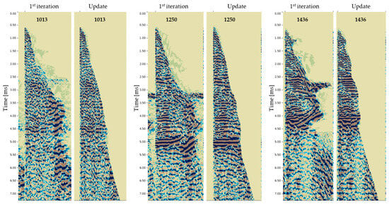
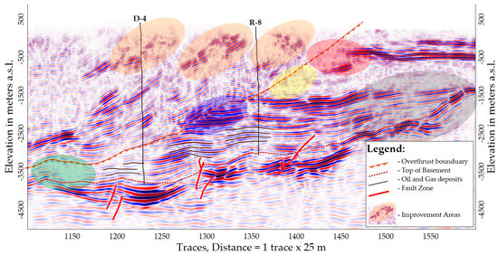
Seismic attributes are widely used to enhance the interpretation of structural, stratigraphic, and lithologic features in subsurface data. Their effectiveness, however, can be limited by noise, resolution constraints, and processing artifacts. This study suggests new seismic attributes computed using 2D-Variational Mode Decomposition (2D-VMD), which are specifically Mode-Weighted Spectral Discontinuity (MWSD) (in Module and Phase modes), VMD-Directionality Coherence (VDC), Instantaneous Frequency Concentration (IFC-VMD), and Instantaneous Bandwidth Dispersion (IBD-VMD). The proposed 2D-VMD-based attributes are compared with seven key conventional seismic attributes: dip, azimuth, chaos, coherence (semblance), curvature (mean curvature), instantaneous frequency, and instantaneous bandwidth (Hilbert transform). Through applications on simulated and real seismic data, each method is compared in terms of its ability to enhance attribute stability, resolution, and interpretability while mitigating limitations such as noise sensitivity and loss of detail. Results indicate that MWSD (Module) is optimal for amplitude stability, MWSD (Phase) for phase-sensitive applications, VDC for high-resolution structural delineation, IFC-VMD for complex geological settings, and IBD-VMD for abrupt feature changes. The findings demonstrate that these new 2D-VMD-based techniques provide significant advantages over traditional approaches and that combining complementary methods can further improve seismic interpretation outcomes.
Full article

Figure 1


