applsci-logo

Journal Browser

Journal Browser

Geoinformatics and Data Mining in Earth Sciences

A topical collection in Applied Sciences (ISSN 2076-3417). This collection belongs to the section "Earth Sciences".

Viewed by 59673
Printed Edition Available!
A printed edition of this Special Issue is available here.

Editors


E-Mail Website
Collection Editor
Geophysical Center of the Russian Academy of Sciences (GC RAS), 119296 Moscow, Russia
Interests: geophysics; algorithmic systems analysis; big data; geoinformatics; earth magnetic field; earth sciences data mining; pattern recognition; seismic zonation

E-Mail Website
Collection Editor
Geophysical Center of the Russian Academy of Sciences (GC RAS), 119296 Moscow, Russia
Interests: geophysics; algorithmic systems analysis; big data; geoinformatics; earth magnetic field; earth sciences data mining; pattern recognition; seismic zonation

Topical Collection Information

Dear Colleagues,

The modern intensive accumulation of data on the wide range of observations in Earth Sciences requires sufficient methods and techniques for their comprehensive analysis and data mining. The analysis of data on potentially hazardous natural events such as earthquakes, tsunami, avalanches, landslides, geomagnetic storms, volcanic eruptions, mudflows, subsidence, floods, forest fires, tornadoes, etc. is of special significance. Analysis, assessment, and prediction of natural hazards are vital problems in the Earth Sciences.

This Topical Collection will present an outlook of modern Data Science approaches of geoinformatics and data mining in application to a wide range of Earth Sciences disciplines, including the hazard studies listed above. Applications of systems analysis, geographic systems, data mining, Big Data aspects, etc. are welcome to this Topical Collection. Particular attention will also be paid to the preservation of historical geodata.

We welcome original articles from various fields of Earth Sciences and Data Science. Articles dealing with interdisciplinary problems and challenges in Earth Sciences are especially welcome. Papers devoted to applications of Big Data theory and practice in geosciences are of particular interest.

Prof. Dr. Alexei Gvishiani
Dr. Boris Dzeboev
Collection Editors

Manuscript Submission Information

Manuscripts should be submitted online at www.mdpi.com by registering and logging in to this website. Once you are registered, click here to go to the submission form. Manuscripts can be submitted until the deadline. All submissions that pass pre-check are peer-reviewed. Accepted papers will be published continuously in the journal (as soon as accepted) and will be listed together on the collection website. Research articles, review articles as well as short communications are invited. For planned papers, a title and short abstract (about 100 words) can be sent to the Editorial Office for announcement on this website.

Submitted manuscripts should not have been published previously, nor be under consideration for publication elsewhere (except conference proceedings papers). All manuscripts are thoroughly refereed through a single-blind peer-review process. A guide for authors and other relevant information for submission of manuscripts is available on the Instructions for Authors page. Applied Sciences is an international peer-reviewed open access semimonthly journal published by MDPI.

Please visit the Instructions for Authors page before submitting a manuscript. The Article Processing Charge (APC) for publication in this open access journal is 2400 CHF (Swiss Francs). Submitted papers should be well formatted and use good English. Authors may use MDPI's English editing service prior to publication or during author revisions.

Keywords

  • geophysics
  • geoinformatics
  • Earth sciences data mining

Published Papers (22 papers)

2024

Jump to: 2023, 2022, 2021

15 pages, 667 KiB  
Article
Investigation of Structural Seismic Vulnerability Using Machine Learning on Rapid Visual Screening
by Ioannis Karampinis, Lazaros Iliadis and Athanasios Karabinis
Appl. Sci. 2024, 14(12), 5350; https://doi.org/10.3390/app14125350 - 20 Jun 2024
Viewed by 807
Abstract
Seismic vulnerability assessment is one of the most impactful engineering challenges faced by modern societies. Thus, authorities require a reliable tool that has the potential to rank given structures according to their seismic vulnerability. Various countries and organizations over the past decades have [...] Read more.
Seismic vulnerability assessment is one of the most impactful engineering challenges faced by modern societies. Thus, authorities require a reliable tool that has the potential to rank given structures according to their seismic vulnerability. Various countries and organizations over the past decades have developed Rapid Visual Screening (RVS) tools aiming to efficiently estimate vulnerability indices. In general, RVS tools employ a set of structural features and their associated weights to obtain a vulnerability index, which can be used for ranking. In this paper, Machine Learning (ML) models are implemented within this framework. The proposed formulation is used to train binary classifiers in conjunction with ad hoc rules, employing the features of various Codes (e.g., the Federal Emergency Management Agency, New Zealand, and Canada). The efficiency of this modeling effort is evaluated for each Code separately and it is clearly demonstrated that ML-based models are capable of outperforming currently established engineering practices. Furthermore, in the spirit of the aforementioned Codes, a linearization of the fully trained ML model is proposed. ML feature attribution techniques, namely SHapley Additive exPlanations (SHAP) are employed to introduce weights similar to engineering practices. The promising results motivate the potential applicability of this methodology towards the recalibration of the RVS procedures for various types of cases. Full article
Show Figures

Figure 1

2023

Jump to: 2024, 2022, 2021

30 pages, 16271 KiB  
Article
Integrated Earthquake Catalog III: Gakkel Ridge, Knipovich Ridge, and Svalbard Archipelago
by Inessa A. Vorobieva, Alexei D. Gvishiani, Peter N. Shebalin, Boris A. Dzeboev, Boris V. Dzeranov, Natalia A. Sergeeva, Ernest O. Kedrov and Yuliya V. Barykina
Appl. Sci. 2023, 13(22), 12422; https://doi.org/10.3390/app132212422 - 16 Nov 2023
Cited by 2 | Viewed by 1358
Abstract
This paper represents the final part of a series of studies aimed at creating the most reliable and representative earthquake catalog covering the Russian and European Arctic. The earthquake catalog of the Gakkel and Knipovich ridges, as well as the Svalbard Archipelago with [...] Read more.
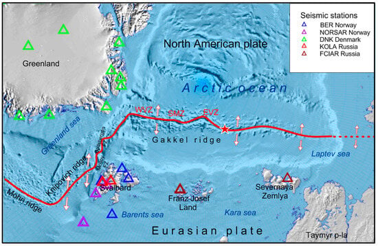
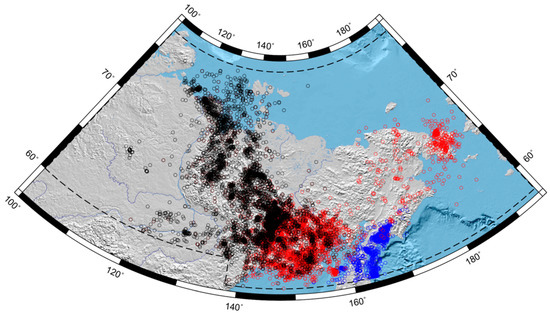
This paper represents the final part of a series of studies aimed at creating the most reliable and representative earthquake catalog covering the Russian and European Arctic. The earthquake catalog of the Gakkel and Knipovich ridges, as well as the Svalbard Archipelago with a unified magnitude scale, was formed based on the combination of four regional Russian catalogs and the ISC catalog. The merging of catalogs was carried out using the modification of the author’s methodology, which allowed for the identification of records in different datasets related to the same seismic event. The modification was introduced due to significant changes over time in the source catalogs. The unified proxy moment magnitude scale was formed based on regression analysis of the different magnitude estimates provided by various agencies. The integrated catalog included 17,922 earthquakes that occurred during the period 1962–2022. Analysis of the integrated catalog showed that the level of registration in the studied area significantly varies over space and time. Before 1995, the catalog contained only strong and moderate earthquakes, and the magnitude of complete registration Mc was 5.0 in the Gakkel Ridge, 4.7 in the Knipovich Ridge, and 4.5 in the Svalbard Archipelago. The number of recorded events increased in the period 1995–2011, and Mc decreased to 4.0 in the Gakkel and Knipovich ridges and to 2.8 in the Svalbard Archipelago. The best level of registration in the Svalbard Archipelago and the Knipovich Ridge was achieved after 2012, when Mc reached 1.7 and 2.8, respectively. In the Gakkel Ridge, despite a noticeable increase in the number of reported events from 2012, the magnitude of complete registration did not improve and was 4.0. The presented integrated earthquake catalog is intended for a wide range of studies of the seismic regime of the Arctic. Full article
Show Figures

Figure 1

11 pages, 3248 KiB  
Article
Singular Points of the Tremor of the Earth’s Surface
by Alexey Lyubushin
Appl. Sci. 2023, 13(18), 10060; https://doi.org/10.3390/app131810060 - 6 Sep 2023
Cited by 2 | Viewed by 3716
Abstract
A method for studying properties of the Earth’s surface tremor, measured by means of GPS, is proposed. The following tremor characteristics are considered: the entropy of wavelet coefficients, the Donoho–Johnston wavelet index, and two estimates of the spectral slope. The anomalous areas of [...] Read more.
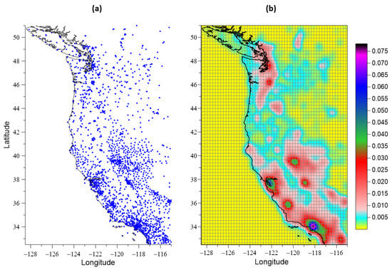
A method for studying properties of the Earth’s surface tremor, measured by means of GPS, is proposed. The following tremor characteristics are considered: the entropy of wavelet coefficients, the Donoho–Johnston wavelet index, and two estimates of the spectral slope. The anomalous areas of tremor are determined by estimating the probability densities of extreme values of the studied properties. The criteria for abnormal tremor behavior are based on the proximity to, or the difference between, tremor properties and white noise. The greatest deviation from the properties of white noise is characterized by entropy minima and spectral slope and DJ index maxima. This behavior of the tremor is called “active”. The “passive” tremor behavior is characterized by the maximum proximity to the properties of white noise. The principal components approach provides weighted averaged density maps of these two variants of extreme distributions of parameters in a moving time window of 3 years. Singular points are the points of maximum average densities. The method is applied to the analysis of daily time series from a GPS network in California during the period 2009–2022. Singular points of tremor form well-defined clusters were found. The passive tremor could be caused by the activation of movement in fragments of the San Andreas fault. Full article
Show Figures

Figure 1

19 pages, 2689 KiB  
Article
Real-Time Adjustment and Spatial Data Integration Algorithms Combining Total Station and GNSS Surveys with an Earth Gravity Model
by Krzysztof Karsznia, Edward Osada and Zbigniew Muszyński
Appl. Sci. 2023, 13(16), 9380; https://doi.org/10.3390/app13169380 - 18 Aug 2023
Cited by 2 | Viewed by 1305
Abstract
During the dynamic development of modern technologies based on advanced algorithmic and instrumental solutions, it is essential to integrate geospatial data efficiently. Such an approach is applied in all geo-information services, especially mobile ones, and is helpful in, for example, precise navigation or [...] Read more.
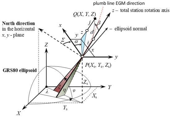
During the dynamic development of modern technologies based on advanced algorithmic and instrumental solutions, it is essential to integrate geospatial data efficiently. Such an approach is applied in all geo-information services, especially mobile ones, and is helpful in, for example, precise navigation or effective risk management. One leading application is deformation monitoring (structural monitoring) and displacement control surveying. In addition, spatial data integration methods are used in modern accessibility analysis, Smart City ideas, tracing utility networks, and building information modelling (BIM). The last aforementioned technology plays a crucial role in architectural design and construction. In this context, it is crucial to develop efficient and accurate algorithms supporting data fusion, which do not strain the computing resources and operate efficiently online. This paper proposes an algorithm for real-time adjustment of integrated satellite GNSS (global navigation satellite system), total station, and Earth Gravitational Model (EGM) vertical direction data in a geocentric coordinate system based on a statistical general linear mixed model. A numerical example shows that the proposed algorithm of the online adjustment works correctly. The results of the online adjustment are the same as those of the offline adjustment. It is also shown that the GNSS measurements are necessary only at the total station points in the spatial total station traverse. There is no need to add additional merging points of the total station positions because the differences between the results of the online adjustment, including and excluding the merging points, are very small (around 1–2 mm in standard deviation). Full article
Show Figures

Figure 1

24 pages, 9414 KiB  
Article
Integrated Earthquake Catalog II: The Western Sector of the Russian Arctic
by Inessa A. Vorobieva, Alexei D. Gvishiani, Peter N. Shebalin, Boris A. Dzeboev, Boris V. Dzeranov, Anna A. Skorkina, Natalia A. Sergeeva and Natalia A. Fomenko
Appl. Sci. 2023, 13(12), 7084; https://doi.org/10.3390/app13127084 - 13 Jun 2023
Cited by 8 | Viewed by 1348
Abstract
The article is a continuation of the research on creating the most complete and representative earthquake catalogs by combining all available data from regional, national, and international seismological agencies and reducing magnitudes to a uniform scale. The task of identifying and removing duplicates [...] Read more.
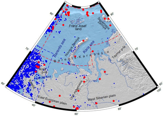
The article is a continuation of the research on creating the most complete and representative earthquake catalogs by combining all available data from regional, national, and international seismological agencies and reducing magnitudes to a uniform scale. The task of identifying and removing duplicates that arise during the merging process is solved using the authors’ modification of the nearest neighbor method. It is evident that the intelligent merging of different earthquake catalogs for the same territory will improve the completeness and representativeness of events in the final integrated catalog. In this article, the earthquake catalog of the western sector of the Arctic zone of the Russian Federation (AZRF) covering the period 1962–2022 was created by merging three regional Russian catalogs and the ISC catalog. The ratio of magnitude types in the catalog for different seismic networks was analyzed, and magnitude estimates were unified based on the obtained ratios. For analyzing seismic activity in the western AZRF, it is recommended to use earthquakes from the period 1998–2020 when the catalog was significantly cleaned from explosions and other events of the “non-earthquake” type. Full article
Show Figures

Figure 1

37 pages, 51001 KiB  
Article
Electronic Atlas of Climatic Changes in the Western Russian Arctic in 1950–2021 as Geoinformatic Support of Railway Development
by Alexei D. Gvishiani, Igor N. Rozenberg, Anatoly A. Soloviev, Andrey G. Kostianoy, Sofia A. Gvozdik, Ilya V. Serykh, Roman I. Krasnoperov, Nikolay V. Sazonov, Irina A. Dubchak, Anton B. Popov, Evgenia A. Kostianaia and Georgy A. Gvozdik
Appl. Sci. 2023, 13(9), 5278; https://doi.org/10.3390/app13095278 - 23 Apr 2023
Cited by 6 | Viewed by 2856
Abstract
The Arctic zone of the Russian Federation is one of the most intensively developing regions of the country. Amongst the major domains of economic and industrial growth and improvement is transport infrastructure and particularly the railway network. This area is being exposed to [...] Read more.
The Arctic zone of the Russian Federation is one of the most intensively developing regions of the country. Amongst the major domains of economic and industrial growth and improvement is transport infrastructure and particularly the railway network. This area is being exposed to negative factors of rapid climate change that can significantly affect and compromise this activity. Thus, it is vital to take them into account during design, construction, and operation of the railway infrastructure facilities. This work details the production of a digital atlas comprising the 1950–2021 dynamics of the main hydrometeorological parameters: air and soil temperature, precipitation, wind speed, air and soil humidity, and snow cover thickness. The maps are based on climatic data derived from the MERRA-2 (Modern-Era Retrospective Analysis for Research and Applications, version 2) reanalysis. In total there are 459, which are arranged into 7 chapters. The atlas geographically covers the western part of the Russian Arctic encompassing the regions of quite intensive transport development, which includes the construction of the Northern Latitudinal Railway. Original algorithms of geospatial data processing and their further representation as well as the maps compiled in GIS environment are discussed. Comprehensive analysis of climatic changes in the region of the Russian Arctic including detailed quantitative evaluation over 40 years is given. In the Discussion, we focus on those changes of the regional climate which, from our point of view, are the most significant for consideration by railway operators. The obtained results contribute to framing the theoretical basis of design, development, and sustainable operation of the railway infrastructure in the Arctic and facilitate the decision-making process. This is the first experience of building a specialized climatic cartographic product for the needs of the Russian railways, and to our knowledge the first atlas such as that in the world. In the future, the amassed experience may be transferred to other regions of the Russian Federation as well as similar regions in Canada, Sweden and Highland China that are also subject to significant climate change. Full article
Show Figures

Figure 1

2022

Jump to: 2024, 2023, 2021

16 pages, 4482 KiB  
Article
Strong Earthquake-Prone Areas in the Eastern Sector of the Arctic Zone of the Russian Federation
by Alexei D. Gvishiani, Boris A. Dzeboev, Boris V. Dzeranov, Ernest O. Kedrov, Anna A. Skorkina and Izabella M. Nikitina
Appl. Sci. 2022, 12(23), 11990; https://doi.org/10.3390/app122311990 - 23 Nov 2022
Cited by 4 | Viewed by 1590
Abstract
This paper continues the series of publications by the authors on the recognition of areas prone to the strongest, strong, and significant earthquakes using the FCAZ system-analytical method. The areas prone to earthquakes with M ≥ 5.5 in the eastern sector of the [...] Read more.
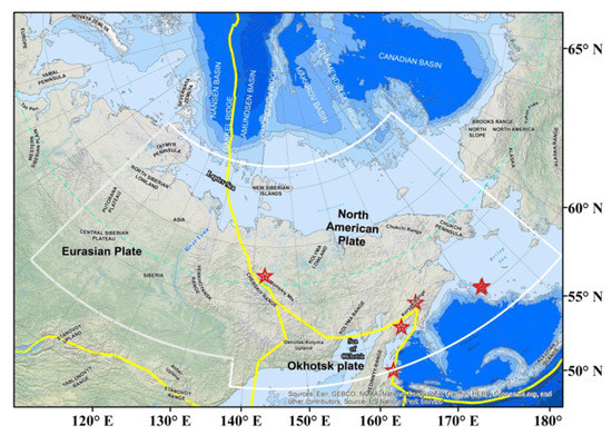
This paper continues the series of publications by the authors on the recognition of areas prone to the strongest, strong, and significant earthquakes using the FCAZ system-analytical method. The areas prone to earthquakes with M ≥ 5.5 in the eastern sector of the Arctic zone of the Russian Federation were recognized. It is shown that certain potential high seismicity zones are well confined to the boundaries of the Eurasian, North American, and Okhotsk tectonic plates. In addition, according to the results of the FCAZ recognition, some areas located at a sufficient distance from the main tectonic structures of the studied region were also recognized as highly seismic. The results of the study, among other factors, justify the use of the assessment of the completeness magnitude in the catalog for choosing the set of recognition objects for the FCAZ method. Full article
Show Figures

Figure 1

16 pages, 2948 KiB  
Article
Deep Transfer Learning Model for Semantic Address Matching
by Liuchang Xu, Ruichen Mao, Chengkun Zhang, Yuanyuan Wang, Xinyu Zheng, Xingyu Xue and Fang Xia
Appl. Sci. 2022, 12(19), 10110; https://doi.org/10.3390/app121910110 - 8 Oct 2022
Cited by 9 | Viewed by 3346
Abstract
Address matching, which aims to match an input descriptive address with a standard address in an address database, is a key technology for achieving data spatialization. The construction of today’s smart cities depends heavily on the precise matching of Chinese addresses. Existing methods [...] Read more.
Address matching, which aims to match an input descriptive address with a standard address in an address database, is a key technology for achieving data spatialization. The construction of today’s smart cities depends heavily on the precise matching of Chinese addresses. Existing methods that rely on rules or text similarity struggle when dealing with nonstandard address data. Deep-learning-based methods often require extracting address semantics for embedded representation, which not only complicates the matching process, but also affects the understanding of address semantics. Inspired by deep transfer learning, we introduce an address matching approach based on a pretraining fine-tuning model to identify semantic similarities between various addresses. We first pretrain the address corpus to enable the address semantic model (abbreviated as ASM) to learn address contexts unsupervised. We then build a labelled address matching dataset using an address-specific geographical feature, allowing the matching problem to be converted into a binary classification prediction problem. Finally, we fine-tune the ASM using the address matching dataset and compare the output with several popular address matching methods. The results demonstrate that our model achieves the best performance, with precision, recall, and an F1 score above 0.98. Full article
Show Figures

Figure 1

24 pages, 28984 KiB  
Article
Data Management and Processing in Seismology: An Application of Big Data Analysis for the Doublet Earthquake of 2021, 03 March, Elassona, Central Greece
by Alexandra Moshou, Antonios Konstantaras, Panagiotis Argyrakis, Nikolaos S. Petrakis, Theodoros N. Kapetanakis and Ioannis O. Vardiambasis
Appl. Sci. 2022, 12(15), 7446; https://doi.org/10.3390/app12157446 - 25 Jul 2022
Cited by 3 | Viewed by 2357
Abstract
On 3 March 2021 (10:16, UTC), a strong earthquake, Mw 6.3, occurred in Elassona, Central Greece. The epicenter was reported 10 km west of Tyrnavos. Another major earthquake followed this event on the same day at Mw 5.8 (3 March 2021, [...] Read more.
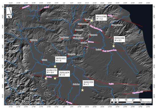
On 3 March 2021 (10:16, UTC), a strong earthquake, Mw 6.3, occurred in Elassona, Central Greece. The epicenter was reported 10 km west of Tyrnavos. Another major earthquake followed this event on the same day at Mw 5.8 (3 March 2021, 11:45, UTC). The next day, 4 March 2021 (18:38, UTC), there was a second event with a similar magnitude as the first, Mw 6.2. Both events were 8.5 km apart. The following analysis shows that the previous events and the most significant aftershocks were superficial. However, historical and modern seismicity has been sparse in this area. Spatially, the region represents a transitional zone between different tectonic domains; the right-lateral slip along the western end of the North Anatolian Fault Zone (NAFZ) in the north Aegean Sea plate-boundary structure ends, and crustal extension prevails in mainland Greece. These earthquakes were followed by rich seismic activity recorded by peripheral seismographs and accelerometers. The installation of a dense, portable network from the Aristotle University of Thessaloniki team also helped this effort, installed three days after the seismic excitation, as seismological stations did not azimuthally enclose the area. In the present work, a detailed analysis was performed using seismological data. A seismological catalogue of 3.787 events was used, which was processed with modern methods to calculate 34 focal mechanisms (Mw > 4.0) and to recalculate the parameters of the largest earthquakes that occurred in the first two days. Full article
Show Figures

Figure 1

13 pages, 10071 KiB  
Article
Identification of Areas of Anomalous Tremor of the Earth’s Surface on the Japanese Islands According to GPS Data
by Alexey Lyubushin
Appl. Sci. 2022, 12(14), 7297; https://doi.org/10.3390/app12147297 - 20 Jul 2022
Cited by 3 | Viewed by 2098
Abstract
Statistical properties of Earth surface tremors measured by means of GPS were investigated. This article considers measurements of the Earth’s surface displacements in three orthogonal directions relayed by a network of GPS sensors with about 1200 points distributed across Japan in 2009–2021. Next, [...] Read more.
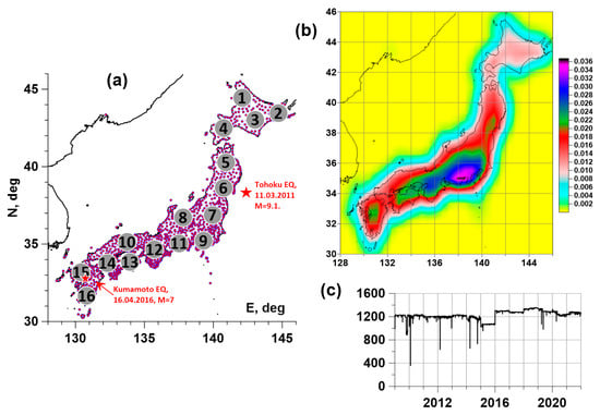
Statistical properties of Earth surface tremors measured by means of GPS were investigated. This article considers measurements of the Earth’s surface displacements in three orthogonal directions relayed by a network of GPS sensors with about 1200 points distributed across Japan in 2009–2021. Next, the following characteristics of the tremors were considered: the entropy of the distribution of squared orthogonal wavelet coefficients, the entropy of the distribution of power spectrum values, and the spectral index. The anomalous regions of maxima of probability densities of the distribution of extreme values of the tremor statistics were determined: entropy minima and spectral index maxima. The average density maps of the distribution of extreme value tremor statistics were found to be highly correlated with one another. This made it possible to consider a weighted average density map and identify five anomalous regions in the center and south of Japan. A trajectory of visiting anomalous regions by a sequence of points realizing local maxima of the average probability density was obtained, for which seasonal periodicity was set. Estimates of changes in the average and maximum values of the correlation coefficients of tremor properties in an auxiliary network of 16 reference points in a semi-annual time window were obtained. Full article
Show Figures

Figure 1

30 pages, 5184 KiB  
Article
A Spatial Fuzzy Co-Location Pattern Mining Method Based on Interval Type-2 Fuzzy Sets
by Jinyu Guo and Lizhen Wang
Appl. Sci. 2022, 12(12), 6259; https://doi.org/10.3390/app12126259 - 20 Jun 2022
Cited by 1 | Viewed by 1404
Abstract
The goal of spatial co-location pattern mining is to find subsets of spatial features whose instances are often neighbors in a geographical space. In many practical cases, instances of spatial features contain not only spatial location information but also attribute information. Although there [...] Read more.
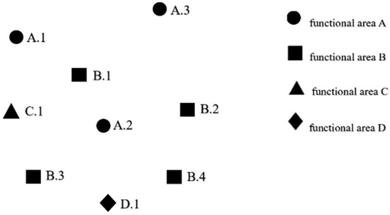
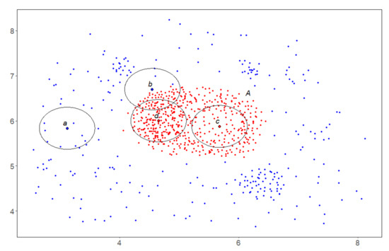
The goal of spatial co-location pattern mining is to find subsets of spatial features whose instances are often neighbors in a geographical space. In many practical cases, instances of spatial features contain not only spatial location information but also attribute information. Although there have been several studies that use type-1 fuzzy membership functions to mine spatial fuzzy co-location patterns, there is great uncertainty associated with such membership functions. To address this problem, we propose a spatial fuzzy co-location pattern mining method based on interval type-2 fuzzy sets. First, we collect the interval evaluation values of the interval data of attribute information from experts to form granular data. Next, the original type-1 fuzzy membership function is extended to a granular type-2 fuzzy membership function based on elliptic curves. We use a gradual method to adjust the parameters of the fuzzy membership function so that its footprint of uncertainty satisfies both the connectivity and the given confidence. Based on this granular type-2 fuzzy membership function, we fuzzify the attribute information of instances and define the concepts of fuzzy features and fuzzy co-location patterns. A fuzzy co-location pattern mining algorithm based on spatial cliques is then proposed, termed the FCPM-Clique algorithm. In order to improve the efficiency of the algorithm, we propose two pruning strategies. In addition, we extend two classical spatial pattern mining algorithms, the Join-based algorithm and the Joinless algorithm, to mine fuzzy co-location patterns based on interval type-2 fuzzy sets. Many experiments on synthetic and real-world datasets are conducted, the performance of the three algorithms is compared, and the effectiveness and efficiency of our proposed FCPM-Clique algorithm is demonstrated. Full article
Show Figures

Figure 1

24 pages, 11362 KiB  
Article
Integrated Earthquake Catalog of the Eastern Sector of the Russian Arctic
by Alexei D. Gvishiani, Inessa A. Vorobieva, Peter N. Shebalin, Boris A. Dzeboev, Boris V. Dzeranov and Anna A. Skorkina
Appl. Sci. 2022, 12(10), 5010; https://doi.org/10.3390/app12105010 - 16 May 2022
Cited by 15 | Viewed by 2414
Abstract
The objective of this study was to create a representative earthquake catalog for the Eastern Sector of the Arctic zone of the Russian Federation that combines all available data from Russian and international seismological agencies, with magnitude reduction to a uniform scale. The [...] Read more.
The objective of this study was to create a representative earthquake catalog for the Eastern Sector of the Arctic zone of the Russian Federation that combines all available data from Russian and international seismological agencies, with magnitude reduction to a uniform scale. The article describes the catalog compilation algorithm, as well as formalized procedures for removing duplicates and choosing the optimal magnitude scale. Due to different network configurations and record processing methods, different agencies may register/miss different events. This results in the absence of some events in different earthquake catalogs. Therefore, merging the data of various seismological agencies will provide the most complete catalog for the studied region. When merging catalogs, the problem of identifying duplicates (records related to the same seismic event) necessarily arises. An additional difficulty arises when distinguishing between aftershocks and duplicates since both are events that are close in space and time. To solve this problem, we used a modified nearest neighbor method developed earlier by the authors. The modified version, which is focused on identifying duplicates and distinguishing between duplicates and aftershocks, uses a probabilistic metric in the network error space to determine the epicenters and times of seismic events. In the present paper, a comparison and regression analysis of the different magnitude types of the integrated catalog is carried out, and based on the obtained ratios, the magnitude estimates are unified. Full article
Show Figures

Figure 1

23 pages, 7579 KiB  
Article
Prospects of Geoinformatics in Analyzing Spatial Heterogeneities of Microstructural Properties of a Tectonic Fault
by Stepan Ustinov, Alexey Ostapchuk, Alexey Svecherevskiy, Alexey Usachev, Grigorii Gridin, Antonina Grigor’eva and Igor Nafigin
Appl. Sci. 2022, 12(6), 2864; https://doi.org/10.3390/app12062864 - 10 Mar 2022
Cited by 3 | Viewed by 3040
Abstract
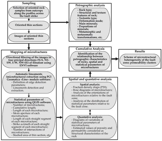
The paper proposes a special technique for microstructural analysis (STMA) of rock samples based on two provisions. The first one is an algorithm for the automatic detection and digitalization of microstructures in images of oriented thin sections. The second one utilizes geographic information [...] Read more.
The paper proposes a special technique for microstructural analysis (STMA) of rock samples based on two provisions. The first one is an algorithm for the automatic detection and digitalization of microstructures in images of oriented thin sections. The second one utilizes geographic information system (GIS) tools for an automatized analysis of objects at the micro scale. Using STMA allows the establishment of geometric features of fissure and pore space of rock samples to determine the parameters of stress–strain fields at different stages of rock massif deformation and to establish a relationship between microstructures and macrostructures. STMA makes it possible to evaluate the spatial heterogeneity of physical and structural properties of rocks at the micro scale. Verification of STMA was carried out using 15 rock samples collected across the core of the Primorsky Fault of the Baikal Rift Zone. Petrographic data were compared to the quantitative parameters of microfracture networks. The damage zone of the Primorsky Fault includes three clusters characterized by different porosity, permeability, and deformation type. Findings point to the efficiency of STMA in revealing the spatial heterogeneity of a tectonic fault. Full article
Show Figures

Figure 1

22 pages, 3265 KiB  
Article
Temporal and Spatial Geophysical Data Analysis in the Issues of Natural Hazards and Risk Assessment (in Example of North Ossetia, Russia)
by Dmitry Melkov, Vladislav Zaalishvili, Olga Burdzieva and Aleksandr Kanukov
Appl. Sci. 2022, 12(6), 2790; https://doi.org/10.3390/app12062790 - 9 Mar 2022
Cited by 6 | Viewed by 2455
Abstract
The paper considers the aspects of hazard assessment within the framework of a generalized approach. The aim of the study is to improve the methodology for more accurate and detailed probabilistic assessments of risks of various nature. A complex hazard map is constructed [...] Read more.
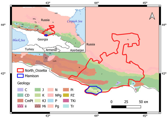
The paper considers the aspects of hazard assessment within the framework of a generalized approach. The aim of the study is to improve the methodology for more accurate and detailed probabilistic assessments of risks of various nature. A complex hazard map is constructed in an example of the territory of the Republic of North Ossetia-Alania and the construction site of the Mamison resort. Based on the analysis of data on Quaternary formations and quantitative estimates, it was concluded that the natural average static environmental evolution proceeds in the mode of the dynamic balance of two factors: mountain building and the equivalent increase in denudation, of which about 90% is transported and deposited by river waters and winds outside the territory. The remaining 10% is deposited in intermountain depressions and river valleys in situ. Geodynamic and climatic factors of influence on the geoenvironment create the danger of excessive environmental impact and disruption of its equilibrium development under anthropogenic impacts, which must be taken into account in designing. Full article
Show Figures

Figure 1

18 pages, 6131 KiB  
Article
Eco-Geophysical and Geoecological Factors in Assessing the State of the Geological Environment Based on the Analysis of Spatial Databases of the Territory of the Republic of North Ossetia–Alania
by Vladislav Zaalishvili, Olga Burdzieva, Aleksandr Kanukov and Tamaz Zaks
Appl. Sci. 2022, 12(5), 2644; https://doi.org/10.3390/app12052644 - 3 Mar 2022
Cited by 4 | Viewed by 2404
Abstract
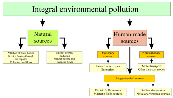
The article considers the main sources of pollutionin the territory of the Republic of North Ossetia–Alania. A study of environmental geophysical factors in the city of Vladikavkaz was carried out at 126 points; indicators of noise pollution, electric fields and the level of [...] Read more.
The article considers the main sources of pollutionin the territory of the Republic of North Ossetia–Alania. A study of environmental geophysical factors in the city of Vladikavkaz was carried out at 126 points; indicators of noise pollution, electric fields and the level of gamma radiation were measured. A geoaccumulation index of heavy metals in soils and indices of carcinogenic and non-carcinogenic risks were calculated and corresponding maps were constructed. The obtained data supporting a high level of carcinogenic risk are consistent with a high level of cancer morbidity in the city, which indicates a close relationship between morbidity and the carcinogenic risk index. It has been determined that emissions from road transport are greater by an order of magnitude than stationary sources emissions, while there is a steady trend towards an increase in air pollution as a result of the increasing negative impact of motor vehicle emissions. It has been established that the most hazardous way for heavy metals to enter the human body from the soil is by inhalation. It has been determined that in areas where environmental pollution with heavy metals is higher, cancer morbidity is also higher. Full article
Show Figures

Figure 1

20 pages, 10231 KiB  
Article
GIS-Based Planning and Web/3D Web GIS Applications for the Analysis and Management of MV/LV Electrical Networks (A Case Study in Tunisia)
by Mohamed Hafedh Hamza and Mohamed Chmit
Appl. Sci. 2022, 12(5), 2554; https://doi.org/10.3390/app12052554 - 28 Feb 2022
Cited by 11 | Viewed by 6339
Abstract
Geographic Information Systems (GISs) have an essential part to play in the management and planning of electricity distribution. Since the management of electricity network data was previously conducted in Tunisia based on paper maps and plans, the purpose of this study is to [...] Read more.
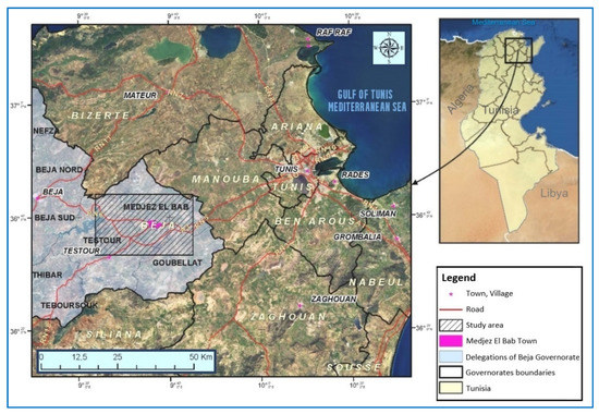
Geographic Information Systems (GISs) have an essential part to play in the management and planning of electricity distribution. Since the management of electricity network data was previously conducted in Tunisia based on paper maps and plans, the purpose of this study is to present a case for the planning of an MV/LV (Medium Voltage/Low Voltage) electrical network in the region of Medjez El Bab (North-West of Tunisia), based on GIS, Web, and 3D Web GIS, to create an intelligent electricity network, which will be a decision-making tool. Analyses of vehicle transport and pedestrian accessibility between installations and a generation of Origin-Destination cost matrix to calculate the average transport distances between the service points were conducted. Moreover, an analysis of the network’s impedance allowed carrying out different scenarios to optimize performance and could obtain more efficient routes. The different analyses carried out were crucial for the maintenance of the electrical network and for future urban planning. A 3D virtual city has been developed to visualize graphical and attribute data for the study area. Web and 3D Web GIS applications that allow the publication of interactive maps on the Web as well as database information have been developed to offer users the possibility of consulting produced products by using the internet. A website related to the study was equally developed to gather the different obtained results. Full article
Show Figures

Figure 1

15 pages, 6782 KiB  
Article
Experiment Study on Mechanical Evolution Characteristics of Coal and Rock under Three-Dimensional Triaxial Stress
by Yabin Tao, Han Du, Ruixin Zhang, Jianzhao Feng and Zhiyun Deng
Appl. Sci. 2022, 12(5), 2445; https://doi.org/10.3390/app12052445 - 26 Feb 2022
Cited by 4 | Viewed by 1864
Abstract
The surrounding rock is in a complex stress environment and its mechanical behavior is also complex, especially after the excavation of the coal seam, the phenomenon of stress release of surrounding rock often occurs. The vertical stress and horizontal stress of the surrounding [...] Read more.
The surrounding rock is in a complex stress environment and its mechanical behavior is also complex, especially after the excavation of the coal seam, the phenomenon of stress release of surrounding rock often occurs. The vertical stress and horizontal stress of the surrounding rock mass will have a series of complex changes. In underground engineering, rock mass is affected by dead weight pressure and tectonic stress. With coal mine production, the original stress of surrounding rock is demolished, and the destruction of surrounding rock is reflected in the loading and unloading failure of three-dimensional stress. Aiming at the phenomenon, this paper takes the Pingshuo East open-pit mine as the research background, and the experiments on physical and mechanical parameters of coal and rock mass was carried out, obtaining the coal and rock mechanics parameters, such as elastic modulus, Poisson’s ratio, internal friction angle, cohesive force, etc. The stress strain curve was created based on the conventional triaxial experiment of coal and rock under different confining pressure conditions. According to the characteristics of these curves, we obtain underground engineering rock mass unloading stress–strain variation characteristics. Through establishing a stress–strain equation based on confining pressure, we finally describe the mechanical failure characteristics of rock under triaxial stress. Full article
Show Figures

Figure 1

17 pages, 9381 KiB  
Article
Dynamic Activity Index for Feature Engineering of Geodynamic Data for Safe Underground Isolation of High-Level Radioactive Waste
by Sergei M. Agayan, Ilya V. Losev, Ivan O. Belov, Victor N. Tatarinov, Alexander I. Manevich and Maksim A. Pasishnichenko
Appl. Sci. 2022, 12(4), 2010; https://doi.org/10.3390/app12042010 - 15 Feb 2022
Cited by 3 | Viewed by 1884
Abstract
In this study, we developed a new approach for feature engineering in geosciences. The main focus of this study was feature engineering based on the implementation of the dynamic activity index (MDAI) as a function of the anomaly of the spatial distribution of [...] Read more.
In this study, we developed a new approach for feature engineering in geosciences. The main focus of this study was feature engineering based on the implementation of the dynamic activity index (MDAI) as a function of the anomaly of the spatial distribution of data, using systems and discrete mathematical analysis. The methodology for calculating MDAI by groups, geomorphological variability, the density of tectonic faults, stress-strain state, and magnetic field anomalies, is presented herein for a specific area. A detailed analysis of the correlation matrix of MDAI revealed weak correlations between the development features. This showed that the considered properties of the geological environment are independent sets and can be used in the analysis of its geodynamic stability. As a result, it was found that most of the territory where high-level radioactive waste (HLRW) disposal is currently planned is in a relatively stable zone. Full article
Show Figures

Figure 1

2021

Jump to: 2024, 2023, 2022

24 pages, 1160 KiB  
Article
Theoretical Framework for Determination of Linear Structures in Multidimensional Geodynamic Data Arrays
by Sergey Agayan, Shamil Bogoutdinov, Dmitriy Kamaev, Vladimir Kaftan, Maxim Osipov and Victor Tatarinov
Appl. Sci. 2021, 11(24), 11606; https://doi.org/10.3390/app112411606 - 7 Dec 2021
Cited by 5 | Viewed by 2270
Abstract
The article addresses the issue of clustering of multidimensional data arrays with a noise using the methods of discrete mathematical analysis (DMA clustering). The theory of DMA clustering through the logical densities calculus is detailed, and the new algorithm Linear Discrete Perfect Sets [...] Read more.
The article addresses the issue of clustering of multidimensional data arrays with a noise using the methods of discrete mathematical analysis (DMA clustering). The theory of DMA clustering through the logical densities calculus is detailed, and the new algorithm Linear Discrete Perfect Sets (LDPS) is described. The main objective of the LDPS algorithm is to identify linearly stretched anomalies in a multidimensional array of geo-spatial data (geophysical fields, geochemistry, satellite images, local topography, maps of recent crustal movements, seismic monitoring data, etc.). These types of anomalies are associated with tectonic structures in the upper part of the Earth’s crust and pose the biggest threat for integrity of the isolation properties of the geological environment, including in regions of high-level radioactive waste disposal. The main advantage of the LDPS algorithm as compared to other cluster analysis algorithms that may be used in arrays with a noise is that it is more focused on searching for clusters that are linear. The LDPS algorithm can apply not only in the analysis of spatial natural objects and fields but also to elongated lineament structures. Full article
Show Figures

Figure 1

22 pages, 2446 KiB  
Article
Use of 2SFCA Method to Identify and Analyze Spatial Access Disparities to Healthcare in Jeddah, Saudi Arabia
by Bandar Fuad Khashoggi and Abdulkader Murad
Appl. Sci. 2021, 11(20), 9537; https://doi.org/10.3390/app11209537 - 14 Oct 2021
Cited by 9 | Viewed by 4742
Abstract
The issue of reducing spatial disparities in access to healthcare is one of the most important healthcare planning issues that policy makers and planners investigate and consider as a key focus until present time. A healthcare system that meets the requirements of availability [...] Read more.
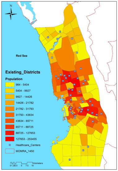
The issue of reducing spatial disparities in access to healthcare is one of the most important healthcare planning issues that policy makers and planners investigate and consider as a key focus until present time. A healthcare system that meets the requirements of availability and affordability will be useless if the spatial accessibility to healthcare is not provided to all equally. Therefore, this study aims to identify and analyze spatial disparities in access to healthcare centers in Jeddah, Saudi Arabia. The two-step floating catchment area (2SFCA) method was used to measure spatial accessibility of healthcare centers based on the travel time threshold (i.e., 30-min drive time in this study). The GIS technology was used to execute the 2SFCA method. A geodatabase, which includes the population districts, locations of healthcare centers, and road network, was created. Some procedures were performed within the road network database to set the travel time that is considered as an essential step to compute the origin–destination (OD) cost matrix. The OD matrix was later used as the source for calculating provider-to-population ratios and the spatial accessibility scores for population districts. The results of the study revealed spatial disparities in access to healthcare centers in Jeddah city. The majority of the Jeddah population (i.e., 97.51%) have accessibility to healthcare centers, but with disparate levels. The central districts have a higher access score compared to the rest of the city’s districts. Most districts that do not have accessibility to healthcare centers are concentrated in the southeast of the city. The results can help local health planners improve spatial equity in access to healthcare centers through giving the less-served districts a priority when allocating future healthcare centers in Jeddah city. Full article
Show Figures

Figure 1

20 pages, 10860 KiB  
Article
Keyboard Model of Seismic Cycle of Great Earthquakes in Subduction Zones: Simulation Results and Further Generalization
by Leopold I. Lobkovsky, Irina S. Vladimirova, Yurii V. Gabsatarov and Dmitry A. Alekseev
Appl. Sci. 2021, 11(19), 9350; https://doi.org/10.3390/app11199350 - 8 Oct 2021
Cited by 4 | Viewed by 2151
Abstract
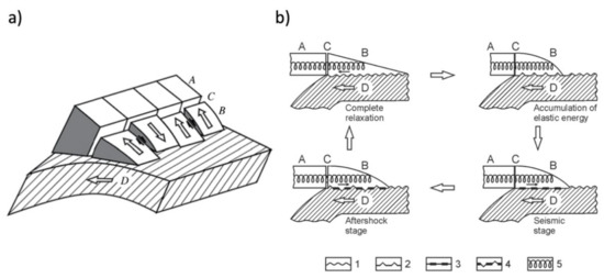
Catastrophic megaearthquakes (M > 8) occurring in the subduction zones are among the most devastating hazards on the planet. In this paper we discuss the seismic cycles of the megathrust earthquakes and propose a blockwise geomechanical model explaining certain features of the stress-deformation [...] Read more.
Catastrophic megaearthquakes (M > 8) occurring in the subduction zones are among the most devastating hazards on the planet. In this paper we discuss the seismic cycles of the megathrust earthquakes and propose a blockwise geomechanical model explaining certain features of the stress-deformation cycle revealed in recent decades from seismological and satellite geodesy (GNSS) observations. Starting with an overview of the so-called keyboard model of the seismic cycle by L. Lobkovsky, we outline mathematical formalism describing the motion of seismogenic block system assuming viscous rheology beneath and between the neighboring elastic blocks sitting on top of the subducting slab. By summarizing the GNSS-based evidence from our previous studies concerning the transient motions associated with the 2006–2007 Simushir earthquakes, 2010 Maule earthquake, and 2011 Tohoku earthquake, we demonstrate that those data support the keyboard model and reveal specific effect of the postseismic oceanward motion. However, since the seismogenic blocks in subduction systems are mostly located offshore, the direct analysis of GNSS-measured displacements and velocities is hardly possible in terms of the original keyboard model. Hence, the generalized two-segment keyboard model is introduced, containing both frontal offshore blocks and rear onshore blocks, which allows for direct interpretation of the onshore-collected GNSS data. We present a numerical computation scheme and a series of simulated data, which exhibits the consistency with measured motions and enables estimating the seismic cycle characteristics, important for the long-term earthquake forecasting. Full article
Show Figures

Figure 1

16 pages, 1697 KiB  
Article
Deep Contrast Learning Approach for Address Semantic Matching
by Jian Chen, Jianpeng Chen, Xiangrong She, Jian Mao and Gang Chen
Appl. Sci. 2021, 11(16), 7608; https://doi.org/10.3390/app11167608 - 19 Aug 2021
Cited by 13 | Viewed by 2825
Abstract
Address is a structured description used to identify a specific place or point of interest, and it provides an effective way to locate people or objects. The standardization of Chinese place name and address occupies an important position in the construction of a [...] Read more.
Address is a structured description used to identify a specific place or point of interest, and it provides an effective way to locate people or objects. The standardization of Chinese place name and address occupies an important position in the construction of a smart city. Traditional address specification technology often adopts methods based on text similarity or rule bases, which cannot handle complex, missing, and redundant address information well. This paper transforms the task of address standardization into calculating the similarity of address pairs, and proposes a contrast learning address matching model based on the attention-Bi-LSTM-CNN network (ABLC). First of all, ABLC use the Trie syntax tree algorithm to extract Chinese address elements. Next, based on the basic idea of contrast learning, a hybrid neural network is applied to learn the semantic information in the address. Finally, Manhattan distance is calculated as the similarity of the two addresses. Experiments on the self-constructed dataset with data augmentation demonstrate that the proposed model has better stability and performance compared with other baselines. Full article
Show Figures

Figure 1

Back to TopTop