Advances in Transportation Planning and Management
A project collection of Sustainability (ISSN 2071-1050). This project collection belongs to the section "Sustainable Transportation".
Papers displayed on this page all arise from the same project. Editorial decisions were made independently of project staff and handled by the Editor-in-Chief or qualified Editorial Board members.
Viewed by 23618
Share This Project Collection
Editors
 Prof. Dr. Hongfei Jia
Prof. Dr. Hongfei Jia
E-Mail
Website
Guest Editor
Transportation College, Jilin University, Changchun 130022, China
Interests: transportation sustainability; traffic network analysis; integrated transportation system planning; connected and autonomous vehicles
 Dr. Anning Ni
Dr. Anning Ni
E-Mail
Website
Guest Editor
Transportation Engineering Department, Shanghai Jiao Tong University, Shanghai 200240, China
Interests: transportation system planning and optimization; transportation system modeling and simulation; smart transportation system
Project Overview
Dear Colleagues,
Recent transportation systems have presented many emerging features on both the supply and demand sides. The innovations in electric vehicles, shared vehicles, connected vehicles, and autonomous driving, coupled with increasing green, efficient, convenient and economical travel needs, pose additional opportunities and challenges for sustainable transportation planning and management. With vehicle technological innovation, telematics, and the application of big data, advanced system planning has the potential to achieve sustainable and smarter mobility.
In this Special Issue, we invite any original research and review articles disseminating innovative and sustainable approaches to transportation planning and management. Research areas may include (but are not limited to) the following:
- Sustainable transportation system planning;
- Sustainable transportation mode promoting;
- Sustainable transport policy and environment;
- Smart transportation management;
- Planning and management for autonomous vehicles;
- Planning and management for shared travel modes;
- Travel behavior analysis and modeling;
- Slow traffic improvements;
- Elderly-oriented and barrier-free transportation systems.
We look forward to receiving your contributions.
Prof. Dr. Hongfei Jia
Dr. Anning Ni
Guest Editors
Manuscript Submission Information
Manuscripts should be submitted online at www.mdpi.com by registering and logging in to this website. Once you are registered, click here to go to the submission form. Manuscripts can be submitted until the deadline. All submissions that pass pre-check are peer-reviewed. Accepted papers will be published continuously in the journal (as soon as accepted) and will be listed together on the collection website. Research articles, review articles as well as short communications are invited. For planned papers, a title and short abstract (about 100 words) can be sent to the Editorial Office for announcement on this website.
Submitted manuscripts should not have been published previously, nor be under consideration for publication elsewhere (except conference proceedings papers). All manuscripts are thoroughly refereed through a single-blind peer-review process. A guide for authors and other relevant information for submission of manuscripts is available on the Instructions for Authors page. Sustainability is an international peer-reviewed open access semimonthly journal published by MDPI.
Please visit the Instructions for Authors page before submitting a manuscript.
The Article Processing Charge (APC) for publication in this open access journal is 2400 CHF (Swiss Francs).
Submitted papers should be well formatted and use good English. Authors may use MDPI's
English editing service prior to publication or during author revisions.
Keywords
- sustainable transportation planning
- smart transportation management
- green travel behavior
Published Papers (16 papers)
Open AccessArticle
Analysis of Regulation of Costs for Operating Buses in a Transport Company
by
Valery Kurganov, Mikhail Gryaznov, Andrey Aduvalin, Liliya Polyakova and Aleksey Dorofeev
Viewed by 748
Abstract
The problem of increasing passenger traffic remains acute for municipal public transport. The value of this indicator is determined by the interest of citizens in this way of making their trips and determines the feasibility of the carrier’s operation. The authors conducted a
[...] Read more.
The problem of increasing passenger traffic remains acute for municipal public transport. The value of this indicator is determined by the interest of citizens in this way of making their trips and determines the feasibility of the carrier’s operation. The authors conducted a study of the problems of public transport services in large- and medium-sized cities, which found that the population’s interest in public urban passenger transport has generally been significantly lost. More than 40% of the city population refuses to travel on public transport, half of the population has questions about the reliability of tariff formation, and the same number of people are not satisfied with the regular route network and schedule. City residents increasingly prefer personal vehicles or taxis for their trips, which negatively affects the revenue side of carriers, as well as the level of social comfort and the quality of life of citizens. Efforts to reduce the operating costs of the carrier are aimed at correcting the current situation with urban transport so that tariffs for transportation are more acceptable for passengers. The formation of tariffs for passenger transportation for transport companies is an urgent and complex task. It is necessary to formulate the tariff in such a way as to cover your own transportation costs in the near future and, at the same time, not exceed the psychological threshold for passengers so as not to cause their negative reaction. In addition, since the transportation of passengers by urban public transport is regulated by the authorities, it is also necessary to provide an economic justification for transportation tariffs. This is difficult in the absence of substantiated indicators of consumption rates of material resources in the transport process. To solve this problem, it is necessary to carefully analyze the current costs of operating the bus fleet, as well as forecast costs for future periods. At different periods, researchers have proposed various approaches for planning the cost of operating a bus fleet. The approach we propose is to use standardization of the consumption of material resources, considering the individual operating conditions of the bus fleet and the influence of various factors.
Full article
►▼
Show Figures
Open AccessArticle
Road–Rail Intermodal Travel Mode Choice Behavior Considering Attitude Factors
by
Boqing Wang, Jiajun Li and Fan Jiang
Viewed by 1185
Abstract
Road–rail intermodal transportation (RRIT) leverages the advantages of multiple transport modes and is crucial for addressing the current issue of imbalanced development in the transportation sector. However, passengers’ behavior in choosing RRIT remains unclear, and it is necessary to optimize travel service quality
[...] Read more.
Road–rail intermodal transportation (RRIT) leverages the advantages of multiple transport modes and is crucial for addressing the current issue of imbalanced development in the transportation sector. However, passengers’ behavior in choosing RRIT remains unclear, and it is necessary to optimize travel service quality through analyzing RRIT choice behavior based on user perceptions. This study designed a stated preference experiment that included both direct and multi-modal travel options. A hybrid choice model considering attitude variables was constructed, and four latent attitude variables—convenience, economy, comfort, and riskiness—were extracted to analyze their impact on intercity travel mode choice behavior under conditions of ticket booking uncertainty. The results revealed that the ticket booking success rate is a critical factor in travelers’ decision-making. Passengers tend to choose travel options with higher ticket booking success rates, even if it entails a slight increase in the ticket prices for the high-speed rail to high-speed rail transfer option. The attitude variables significantly influence intercity travel mode choice behavior, with travelers generally exhibiting a preference for risk avoidance in their travel options. Moreover, there are differences among various groups of travelers in their preferences and demands for the convenience, economy, and comfort aspects of travel options. These research findings can enhance our understanding of the key factors influencing the selection of RRIT services, thereby supporting RRIT designers and planners in improving service quality and facilitating the future growth of RRIT.
Full article
►▼
Show Figures
Open AccessReview
Review and Classification of Objectives in Dynamic Dial-a-Ride Systems: A Triple Bottom Line Approach of Sustainability
by
Sapan Tiwari, Neema Nassir and Patricia Sauri Lavieri
Cited by 1 | Viewed by 1000
Abstract
Dynamic dial-a-ride problems (DDARPs) involve designing routes and schedules for customers with specific origins and destinations. While the optimization of DDARPs has been extensively examined, these analyses often focus solely on economic decisions. The recent literature emphasizes the inclusion of social and environmental
[...] Read more.
Dynamic dial-a-ride problems (DDARPs) involve designing routes and schedules for customers with specific origins and destinations. While the optimization of DDARPs has been extensively examined, these analyses often focus solely on economic decisions. The recent literature emphasizes the inclusion of social and environmental factors in addition to economic considerations for a sustainable transportation system. This paper provides a conceptual review that identifies and classifies the most common DDARP objectives in the three dimensions of the Triple-Bottom-Line (3BL) approach of sustainability: environmental, economic, and social. This study analyzes the interconnections among different objectives and provides insights into multi-objective approaches used in transportation problems. The findings demonstrate the interconnectedness of objectives from different dimensions and highlight the involvement of various stakeholders in decision-making. The results show that optimizing one objective may have implications for other objectives, suggesting a trade-off to be considered. The results reveal that social objectives boost the economic dimension by improving service quality; however, environmental objectives negatively impact the economic dimension. Additionally, a geographical analysis was conducted, which revealed continent-wise variations in research focus and contributions. Future studies should focus more on the social and environmental dimensions to promote a sustainable transportation system.
Full article
►▼
Show Figures
Open AccessArticle
Optimizing Airport Runway Capacity and Sustainability through the Introduction of Rapid Exit Taxiways: A Case Study
by
Francesca Maltinti, Michela Flore, Franco Pigozzi and Mauro Coni
Cited by 1 | Viewed by 1235
Abstract
This contribution arises from the need to respond to the increased air demand of an airport with a sustainable approach that minimizes the land consumption of new runways and reduces the fuel burn and emissions associated with aircraft. A new methodology is presented
[...] Read more.
This contribution arises from the need to respond to the increased air demand of an airport with a sustainable approach that minimizes the land consumption of new runways and reduces the fuel burn and emissions associated with aircraft. A new methodology is presented for designing Rapid Exit Taxiways (RETs), which is applied in improving the runway capacity of Costa Smeralda Airport following both the International Civil Aviation Organization (ICAO) and the Federal Aviation Administration (FAA) guidelines. The optimal scenario resulted from a combination of these guidelines. Using this new approach, it is demonstrated that, through both the introduction of RETs and their positioning along the runway, the hourly capacity of the runway can effectively be improved, consequently enhancing the airport capacity and reducing the runway occupancy time and thus fuel burn and emissions. Moreover, the presence of RETs increases the infrastructure resilience, since airplanes can clear the runway faster in case of flooding in risk areas.
Full article
►▼
Show Figures
Open AccessReview
Research Foundation and Hotspot Analysis of Urban Road Ecology—A Bibliometric Study Based on CiteSpace
by
Xiaofan Yang and Qingfu Liu
Viewed by 884
Abstract
Urban road ecology focuses on the reciprocal interactions between urban road construction and the ecological environment, aiming to provide valuable insights into sustainable urban road construction. The study of road ecology has established a comprehensive research framework since the early 20th century, with
[...] Read more.
Urban road ecology focuses on the reciprocal interactions between urban road construction and the ecological environment, aiming to provide valuable insights into sustainable urban road construction. The study of road ecology has established a comprehensive research framework since the early 20th century, with urban road ecology emerging as its sub-discipline that emphasizes the strategic planning of urban roads and the internal dynamics within urban ecosystems. In order to demonstrate the broader research focus and development prospects of urban road ecology, as well as to explore its distinguishing features compared to traditional road ecology, this study conducted a bibliometric analysis of urban road ecology using CiteSpace software version 6.2.R7 based on the Web of Science (WOS) database for the literature in the last 30 years. The analysis reflected the current state of research in this field across three dimensions: collaborative analysis, co-citation analysis, and keyword analysis. The results of the study revealed a scarcity of key terms and publications between 1993 and 2010, followed by an exponential surge in research activities after 2010. However, both collaborative and keyword analyses indicate a lack of long-term, in-depth research in this area, highlighting the absence of a unified system. On this basis, this paper presents three expectations for future research and briefly discusses the limitations of this study.
Full article
►▼
Show Figures
Open AccessArticle
Analyzing the Impacts of Land Use and Network Features on Passenger Flow Distribution at Urban Rail Stations from a Classification Perspective
by
Yuliang Guo, Zhenjun Zhu, Xiaohong Jiang, Ting Chen and Qing Li
Cited by 1 | Viewed by 951
Abstract
This study employed big data analytics to investigate the impacts of land use and network features on passenger flow distribution at urban rail stations. The aim was to provide decision support for differentiated operational management strategies for various types of rail stations, thereby
[...] Read more.
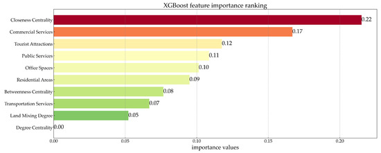
This study employed big data analytics to investigate the impacts of land use and network features on passenger flow distribution at urban rail stations. The aim was to provide decision support for differentiated operational management strategies for various types of rail stations, thereby achieving refined operation and the sustainable development of urban rail systems. First, this study compared clustering results using different similarity measurement functions within the K-means algorithm framework, selecting the optimal similarity measurement function to construct clustering models. Second, factors influencing passenger flow distribution were selected from land use and network features, forming a feature set that when combined with clustering model results, served as input for the XGBoost model to analyze the relationship between various features and the station passenger flow distribution. The case study showed that (1) the clustering results using a dynamic time-warping distance as the similarity measurement function was optimal; (2) the results of the XGBoost model highlighted commercial services and closeness centrality as the most important factors that affected rail station passenger flow distribution; (3) urban rail stations in Nanjing could be categorized into four types: “strong traffic attraction stations”, “balanced traffic attraction stations”, “suburban strong traffic occurrence stations”, and “distant suburban strong traffic occurrence stations”. Differentiated operational and management strategies were developed for these station types. This paper offers a novel approach for enhancing the operational management of urban rail transit, which not only boosts operational efficiency but also aligns with the goals of sustainable development by promoting resource-efficient transportation solutions.
Full article
►▼
Show Figures
Open AccessArticle
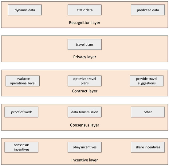
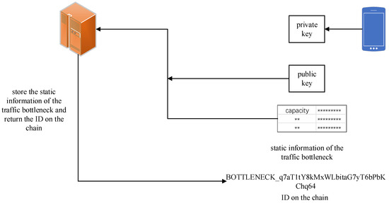
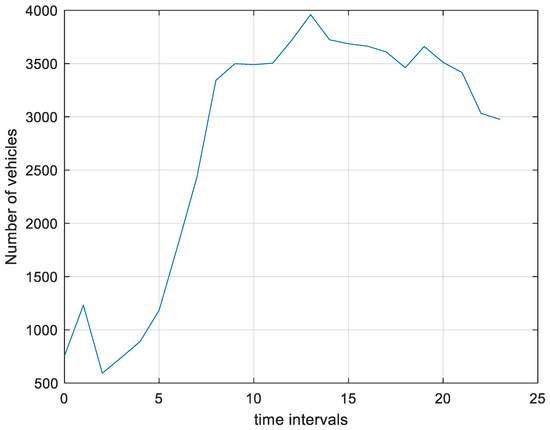
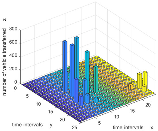
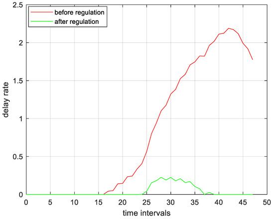
Travel Plan Sharing and Regulation for Managing Traffic Bottleneck Based on Blockchain Technology
by
Senlai Zhu, Hantao Yu and Congjun Fan
Viewed by 849
Abstract
To alleviate traffic congestion, it is necessary to effectively manage traffic bottlenecks. In existing research, travel demand prediction for traffic bottlenecks is based on travel behavior assumptions, and prediction accuracy is low in practice. Thus, the effect of traffic bottleneck management strategies cannot
[...] Read more.
To alleviate traffic congestion, it is necessary to effectively manage traffic bottlenecks. In existing research, travel demand prediction for traffic bottlenecks is based on travel behavior assumptions, and prediction accuracy is low in practice. Thus, the effect of traffic bottleneck management strategies cannot be guaranteed. Management strategies are often mandatory, leading to problems such as unfairness and low social acceptance. To address such issues, this paper proposes managing traffic bottlenecks based on shared travel plans. To solve the information security and privacy problems caused by travel plan sharing and achieve information transparency, travel plans are shared and regulated by blockchain technology. To optimize the operation level of traffic bottlenecks, travel plan regulation models under scenarios where all/some travelers share travel plans are proposed and formulated as linear programming models, and these models are integrated into the blockchain with smart contract technology. Furthermore, travel plan regulation models are tested and verified using traffic flow data from the Su-Tong Yangtze River Highway Bridge, China. The results indicate that the proposed travel plan regulation models are effective for alleviating traffic congestion. The vehicle transfer rate and total delay rate increase as the degree of total demand increases; the vehicle transfer rate increases as the length of the time interval decreases; and the vehicle transfer rate and total delay rate increase as the number of vehicles not sharing their travel plans increases. By using the model and method proposed in this paper, the sustainability of urban economy, society, and environment can be promoted. However, there are many practical situations that have not been considered in this paper, such as multiple entry and exit bottlenecks, multiple travel modes, and other control strategies. In addition, this paper considers only one bottleneck rather than road networks because of the throughput limitations of blockchain technology.
Full article
►▼
Show Figures
Open AccessArticle
Modeling Parking Choice Behavior Using Cumulative Prospect Theory
by
Yang Cao, Yifan Ren, Hongfei Jia, Mingze Sun and Zebo Dali
Cited by 1 | Viewed by 1278
Abstract
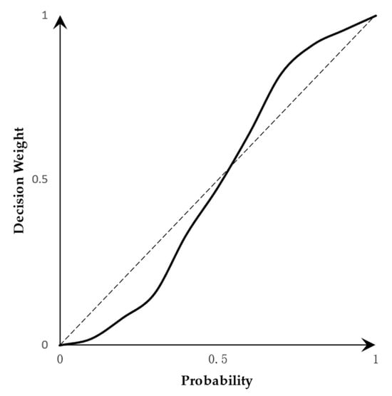
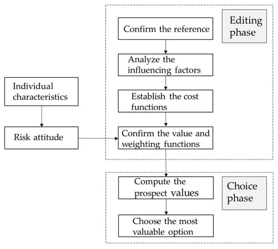
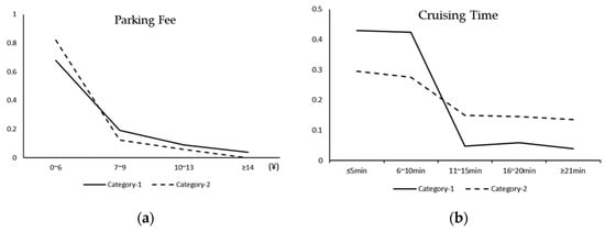
In order to capture the driver’s attitude and preference towards risk during the decision-making process, this paper establishes a parking choice model considering driver heterogeneity based on the cumulative prospect theory. This research innovatively considers the influence of the unreliability of cruise time
[...] Read more.
In order to capture the driver’s attitude and preference towards risk during the decision-making process, this paper establishes a parking choice model considering driver heterogeneity based on the cumulative prospect theory. This research innovatively considers the influence of the unreliability of cruise time on drivers’ parking choice behavior and adds the psychological cost of drivers’ anxiety caused by lateness into the model. At the same time, according to the driver’s parking preference for parking, the latent category model is used to divide the driver into time-sensitive and money-sensitive categories. This paper analyzes the influence of unreliable cruising time on drivers’ parking choice behavior and finds that drivers have the characteristics of overestimating high-probability events and underestimating low-probability events in the decision-making process. By comparing the parking choice results of rational and irrational drivers, it is found that the model considering the risk attitude of drivers in the decision-making process is more in line with reality.
Full article
►▼
Show Figures
Open AccessArticle
Methodological Framework for Sustainable Transport Corridor Modeling Using Petri Nets
by
Igor Kabashkin and Zura Sansyzbayeva
Viewed by 1673
Abstract
Current models for evaluating sustainable transport corridors often lack a comprehensive framework capturing the multifaceted performance measures vital for holistic assessment especially at the early stages of operation, when detailed information on the performance indicators of these transport corridors is not available. This
[...] Read more.
Current models for evaluating sustainable transport corridors often lack a comprehensive framework capturing the multifaceted performance measures vital for holistic assessment especially at the early stages of operation, when detailed information on the performance indicators of these transport corridors is not available. This gap motivates a Petri net-based modeling approach that integrates key sustainability indicators into a flexible simulation tool. This paper details a versatile methodology harnessing Petri nets, specifically Evaluation Petri nets (E-Nets), to assess corridor sustainability across environmental, social, and economic dimensions. The proposed framework equips planners and policymakers to explore diverse green corridor configurations under varying conditions. Case studies showcase the model’s capabilities in analyzing real-world corridors, identifying performance bottlenecks, and comparing alternative solutions. The model provides a practical decision-support tool to strengthen strategies for efficient, socially responsible, and environmentally sound transport infrastructure. This research advances the theoretical foundations and demonstrates the practical value of Petri nets as an enabling methodology for modeling the intricate dynamics of sustainable transport corridors. This paper demonstrates how E-Nets provide a visual and quantitative representation of transport operations, enabling stakeholders to identify inefficiencies and potential improvements. This paper discusses the theoretical underpinnings of the E-Net modeling of transport corridors, the advantages and limitations of its application, and suggests avenues for future research to enhance the model’s predictive power and real-world application. The paper concludes that the E-Net approach is a scalable, adaptable tool that can significantly con-tribute to the sustainable development of international transport corridors, providing a framework for continuous improvement in alignment with global sustainability objectives.
Full article
►▼
Show Figures
Open AccessArticle
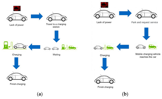
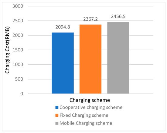
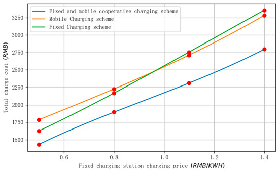
A Charging Planning Method for Shared Electric Vehicles with the Collaboration of Mobile and Fixed Facilities
by
Qingyu Luo, Zhihao Ye and Hongfei Jia
Cited by 2 | Viewed by 1113
Abstract
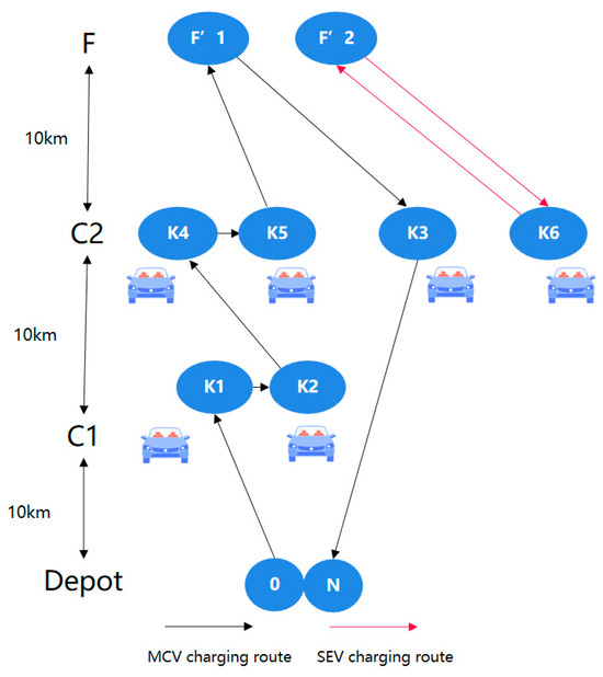
Faced with the charging difficulties of free-floating shared electric vehicles and the high cost of single-demand mobile charging, this paper proposes a cooperative charging planning method based on the complementary advantages of fixed charging stations and mobile charging vehicles, which can charge shared
[...] Read more.
Faced with the charging difficulties of free-floating shared electric vehicles and the high cost of single-demand mobile charging, this paper proposes a cooperative charging planning method based on the complementary advantages of fixed charging stations and mobile charging vehicles, which can charge shared electric vehicles more efficiently and reduce the charging cost at the same time. A bi-level programming model for fixed and mobile cooperative charging is constructed. The upper level of the model is the system charging total cost minimization model, which searches for the optimal charging scheme and number of mobile charging vehicles. The lower level model is a fixed and mobile cooperative charging path planning model, which calculates the optimal routes for the mobile charging vehicles and the shared electric vehicles that need to be transferred to the fixed charging station. The example results show that the cost of the proposed fixed-mobile cooperative charging scheme is reduced by 12.6% when compared to the fixed-only charging scheme, and by 14.9% when compared to the mobile-only charging scheme.
Full article
►▼
Show Figures
Open AccessArticle
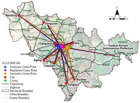
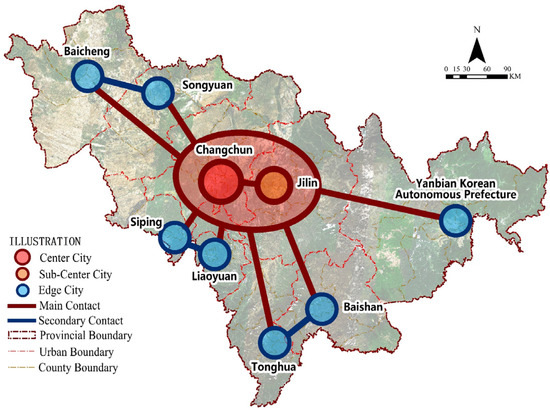
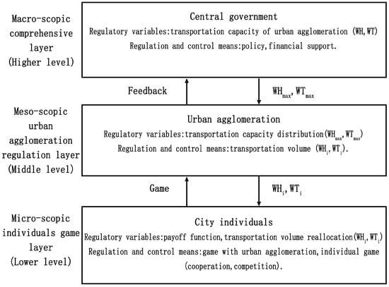
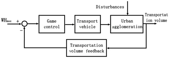
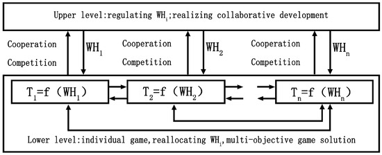
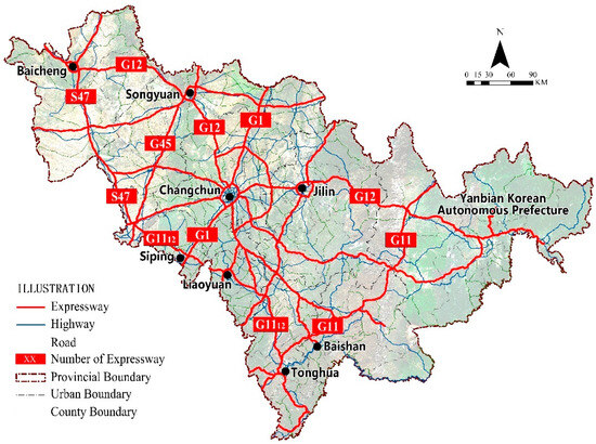
Collaborative Development and Transportation Volume Regulation Strategy for an Urban Agglomeration
by
Shuoqi Wang and Zhanzhong Wang
Cited by 3 | Viewed by 974
Abstract
Transportation plays an important role in urban development and the formation of urban agglomerations. Indexes including urban centrality, urban development intensity, and degree of urban development imbalance are defined to measure the level of urban development, and are taken as the basis for
[...] Read more.
Transportation plays an important role in urban development and the formation of urban agglomerations. Indexes including urban centrality, urban development intensity, and degree of urban development imbalance are defined to measure the level of urban development, and are taken as the basis for transportation regulation within urban agglomerations. Regulation of transportation volume is divided into static and dynamic regulation, and this paper studies static regulation. There are two purposes for static regulation. One is to solve the problems of unbalanced urban development and collaborative development, and the other is to solve the problem of rational utilization of the highway transport network in an urban agglomeration so that the total transportation volume of the urban agglomeration does not exceed the total transportation volume that the transport network can bear, realizing coordinated transport, improving transport efficiency, and reducing traffic congestion and traffic accidents. A distributed intelligent regulation model based on the principle of game control is proposed, which is divided into three layers: macro-regulation (government layer), meso-regulation (urban agglomeration layer), and micro-regulation (individual city game layer). The regulation strategies and methods of the urban agglomeration layer and individual city game layer are given, and are verified and illustrated using as the research object called the Jilin Province urban agglomeration in the northeast of China. The paper contributes to the field by presenting innovative research and provides important theories and methods for collaborative development and transportation within urban agglomerations.
Full article
►▼
Show Figures
Open AccessArticle
Study on the Relationship between the Spatial Distribution of Shared Bicycle Travel Demand and Urban Built Environment
by
Lili Yang, Simeng Fei, Hongfei Jia, Jingdong Qi, Luyao Wang and Xinning Hu
Cited by 3 | Viewed by 1317
Abstract
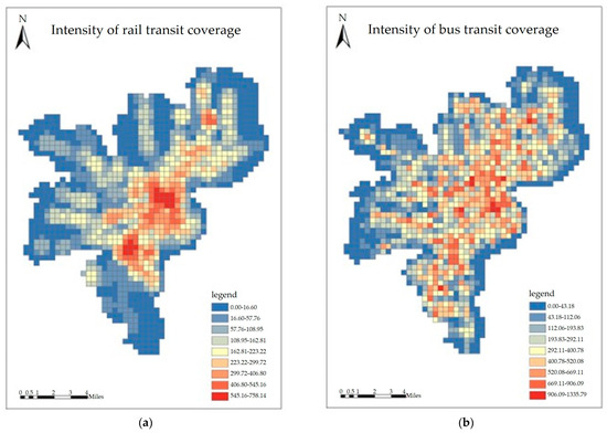
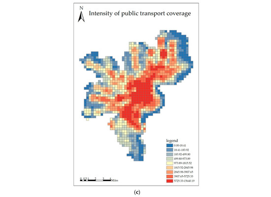
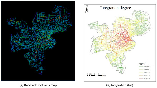
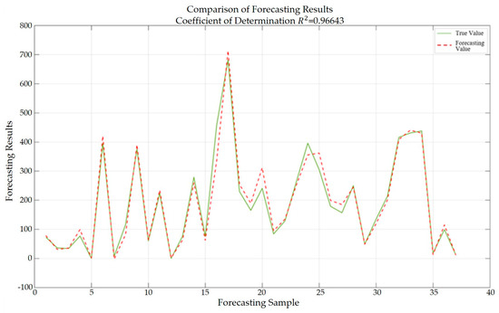
As a green and sustainable trip mode, shared bicycles play an essential role in completing short-distance trips in cities. This paper proposes a method to analyze the impact of the urban built environment on the distribution of shared bicycles in a small-scale space.
[...] Read more.
As a green and sustainable trip mode, shared bicycles play an essential role in completing short-distance trips in cities. This paper proposes a method to analyze the impact of the urban built environment on the distribution of shared bicycles in a small-scale space. First, the Fishnet function of ArcGIS is utilized to divide the study area into grids of 500 m × 500 m. Then, three indicators are proposed to describe the characteristics of the urban built environment, including point of information (POI) comprehensive index, the intensity of public transportation coverage, spatial accessibility, providing them the ways to be assigned to the grids. Finally, the multivariable linear regression model and support vector regression (SVR) models are applied to reveal the impacts of built environment factors on the spatial distribution of shared bicycles. Results show that SVR models based on linear kernel function, Gaussian radial basis kernel function, and Polynomial kernel function can achieve better analysis results. The SVR model based on the Gaussian radial basis function shows higher explanatory power (adjusted
= 0.978) than the multivariable linear regression model (adjusted
= 0.847). This paper can aid in understanding the demand and supply of shared bicycles and help operators or governments to improve service quality.
Full article
►▼
Show Figures
Open AccessReview
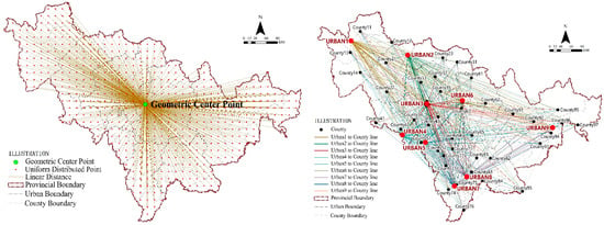
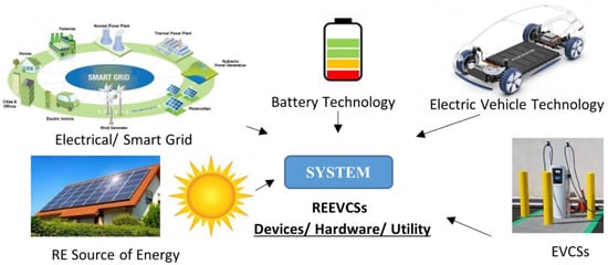
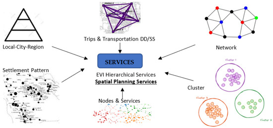
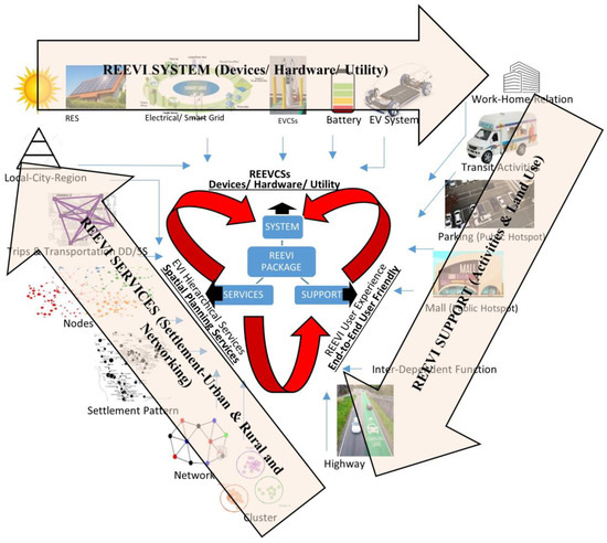
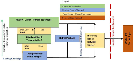
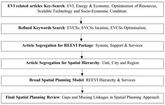
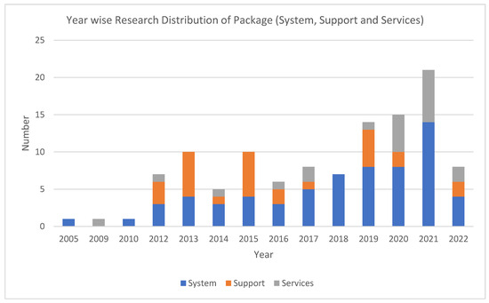
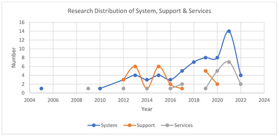
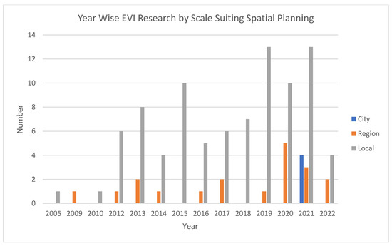
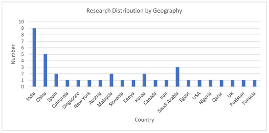
Need of Integrated Regional Planning Approach for the Decentralisation and Optimisation of Renewable Energy Based Electric Vehicle Infrastructure: A Comprehensive Visualisation
by
Geetanjli Rani and Devender Kumar Saini
Viewed by 1781
Abstract
The existing research narrates avenues in the regional and thematic area preconditions set via the framework and institutional mechanism towards energy decentralisation (ED). Moreover, with the entrant stakeholders and inclusive energy policy, the researchers find potential in local resources and capacity towards the
[...] Read more.
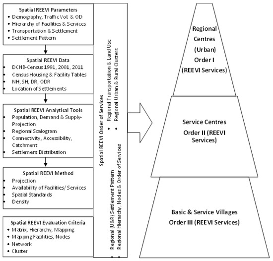
The existing research narrates avenues in the regional and thematic area preconditions set via the framework and institutional mechanism towards energy decentralisation (ED). Moreover, with the entrant stakeholders and inclusive energy policy, the researchers find potential in local resources and capacity towards the decarbonisation of the economy. Consequently, governments around the globe emphasise multi-level sectoral economic support packages to buffer the immediate to medium-term gap and subsequently investigate their implementation in infrastructure and technology. The present review attempts to focus on the conditions of energy transformation in enabling a policy and regulatory framework. As such an integrated regional spatial framework focuses to identify support packages across urban and rural planning, transportation, renewable energy, infrastructure, environment and climate change and sustainability. Moreover, the present review revolves its thematic focus around the transport sector to strategize the energy decentralisation of the local potential in the ongoing electric vehicle (EV) transportation. The presented review toils on EV users’ struggle to orient to the need of the hour in the inadequacies of refill/charging infrastructure. Thus, it is imperative to review parameters such as availability and access to charge, depending on the source of energy in the charging infrastructure, facilities and services at the regional level. The presented review investigates under categoric and key search across conceptual regional settlement hierarchy to strategize the development of the Renewable Energy based Electric Vehicle Infrastructure (REEVI) package under system, support and services (SSS). Conclusively, the review study brings out a tentative regional settlement hierarchical integrated methodology for REEVI-SSS in the missing linkages and gaps of spatial planning to ease medium and long trip EV transportation challenges faced at the inter-city–rural, i.e., regional level.
Full article
►▼
Show Figures
Open AccessArticle
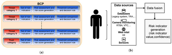
Design, Simulation and Performance Evaluation of a Risk-Based Border Management System
by
Aishvarya Kumar Jain, Jaap de Ruiter, Ivo Häring, Mirjam Fehling-Kaschek and Alexander Stolz
Cited by 2 | Viewed by 1297
Abstract
Border control systems at Europe’s Schengen (and worldwide) borders are necessary to mitigate cross-border threats, but are perceived as free-traveling bottlenecks. Today’s applicable European regulations demand rule-based control schemes and do not allow risk-based elements. A policy shift towards risk-based border control has
[...] Read more.
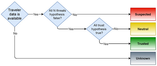
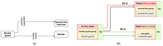
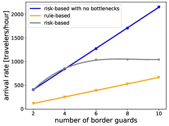
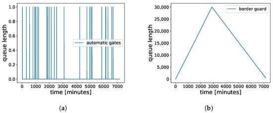
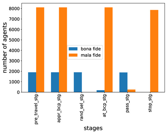
Border control systems at Europe’s Schengen (and worldwide) borders are necessary to mitigate cross-border threats, but are perceived as free-traveling bottlenecks. Today’s applicable European regulations demand rule-based control schemes and do not allow risk-based elements. A policy shift towards risk-based border control has been considered in several studies and research (including HEU projects). However, there is a lack of scientific evidence on how they compare with existing rule-based schemes. This paper aims to fill that gap. The simulation allows design of a realistic border control system. The passenger flow is modeled via travelers with good and bad intents. The border control system includes decision-making elements to classify travelers into risk groups. System elements including operators and their interaction were modeled in terms of statistical distributions based on the subject matter experts’ input. The performance is estimated across security effectiveness, resource usage, passenger flow, and traveler experience. Assessment of a set of simulations reveals better scalability of risk-based systems in terms of resource usage and passenger flow. The potential factors to improve the detection rate of the border control process are also studied. Despite having several benefits, the model demonstrates that social acceptance of the risk-based system is the limiting factor for increased scalability.
Full article
►▼
Show Figures
Open AccessArticle
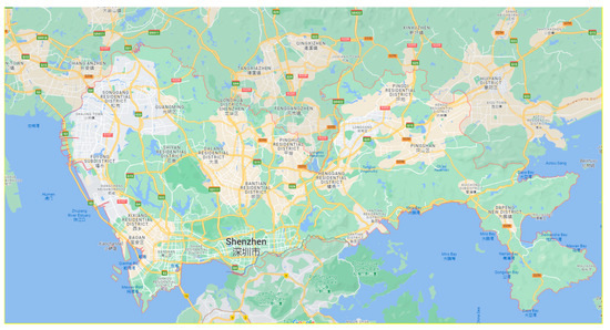
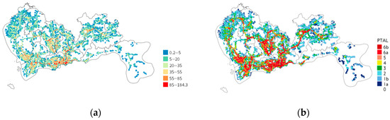
Estimating Public Transportation Accessibility in Metropolitan Areas: A Case Study and Comparative Analysis
by
Haitao Su, Menghan Li, Xiaofeng Zhong, Kai Zhang and Jingkai Wang
Cited by 2 | Viewed by 3821
Abstract
Accessibility-oriented public transportation planning can improve the operational efficiency of public transportation, guide orderly urban development, and alleviate issues such as traffic congestion, environmental pollution, and resource consumption in large cities. To promote the practical application and widespread adoption of public transportation accessibility
[...] Read more.
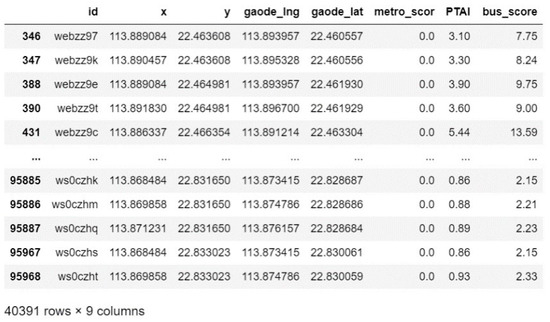
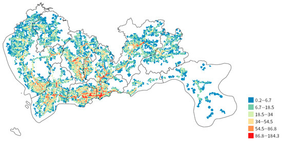
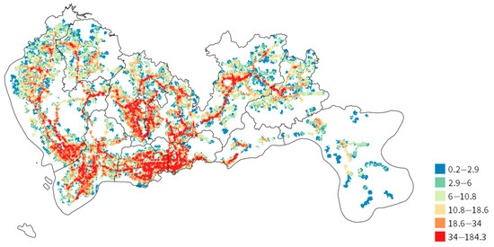
Accessibility-oriented public transportation planning can improve the operational efficiency of public transportation, guide orderly urban development, and alleviate issues such as traffic congestion, environmental pollution, and resource consumption in large cities. To promote the practical application and widespread adoption of public transportation accessibility estimating systems, this study proposes an improved public transport accessibility levels (PTAL) method. It innovatively incorporates residents’ preference indices for different modes of transportation and addresses the challenge of missing timetable data in the calculation process. Using actual data from Shenzhen, a case study is conducted to analyze the public transportation accessibility index and compare the results obtained through k-means clustering, the equal spacing method, the quantile method, and the application of the London PTAL method. The research findings indicate that the optimal number of clusters for public transportation accessibility index analysis in large cities is six when using clustering algorithms. Among the statistical analysis methods, the quantile method shows favorable performance. Furthermore, a comprehensive comparison of different classification methods confirms that the improved PTAL method offers better discrimination in estimating public transportation accessibility levels compared to the London PTAL method. The study concludes by providing guidance on how cities with different characteristics can reference the improved PTAL method.
Full article
►▼
Show Figures
Open AccessArticle
Exploring the Influence of Parking Penalties on Bike-Sharing System with Willingness Constraints: A Case Study of Beijing, China
by
Jiayu Bao, Guojun Chen and Zhenghua Liu
Viewed by 1580
Abstract
Dockless bike-sharing has experienced explosive growth, establishing itself as an integral component of urban public transport systems. Challenges such as parking violations have spurred operators and users to pursue standardized management. While electronic parking spots are employed to promote standard parking, suboptimal parking
[...] Read more.
Dockless bike-sharing has experienced explosive growth, establishing itself as an integral component of urban public transport systems. Challenges such as parking violations have spurred operators and users to pursue standardized management. While electronic parking spots are employed to promote standard parking, suboptimal parking layouts can lead to illegal parking. Inadequate post-violation penalties fail to achieve standard parking, while excessive punishment diminishes user engagement. This study combines parking spot density and penalties to incentivize standard parking, and Beijing, China, was selected as the research object. Using an SP questionnaire survey, a binary logistic model analyzes bike-sharing users’ standard parking behavior and willingness to adhere to different rules. Findings reveal that optimal walking distances range from 300 to 450 m for service levels and exceed 400 m for service efficiency. Influential factors include gender, age, occupation, usage behavior, and travel preferences. Users with high-frequency, low-convenience expectations, low travel costs, and flexible travel exhibit strong adherence. Additionally, user acceptance of the maximum distances without penalties follows an exponential distribution, with 80% accepting 400 m and 40% accepting 800 m. Enforcement has a visible effect within 300 m, but diminishes with longer distances. Excessive penalties result in significant user loss.
Full article
►▼
Show Figures


