Abstract
Inequitable access to parks persists in cities where race, income, and geography shape residents’ proximity to public green space. This study analyzes 20 parks in Salt Lake City—10 in the Eastside and 10 in the Westside—using demographic, housing, and transportation data drawn from GIS tools and spatial platforms. By assessing indicators such as household income, racial composition, rent burden, walkability, and transit access, the findings confirm that Westside parks—located in lower-income and more racially diverse neighborhoods—are significantly less accessible. Eastside parks, by contrast, tend to serve higher-income, majority-white areas with better infrastructure. This paper illustrates how spatial inequality in surrounding conditions limits park accessibility, and it proposes GIS as a tool for diagnosing and addressing environmental injustice in urban planning.
1. Introduction
Urban parks are often described as the lungs of the city, but who gets to breathe easier depends largely on geography, race, and income. In Salt Lake City—as in many U.S. cities—these differences are stark. Research has long shown that low-income communities and communities of color face systemic barriers to accessing high-quality green space [1,2,3]. These disparities in park access are not only physical but also social and economic, shaped by infrastructure, affordability, and transportation [4,5]. This study investigates disparities in park access across 20 neighborhoods, comparing 10 Eastside parks to 10 Westside parks. While all residents theoretically live within reach of public green spaces, this research finds that residents in low-income neighborhoods and communities of color on the Westside face greater challenges in accessing and benefitting from nearby parks. Using a GIS-enabled framework and publicly available data sources, we document how neighborhood demographics, affordability metrics, and mobility infrastructure shape park equity at the local level.
This study is grounded in the Salt Lake City Public Lands Master Plan and focuses on 20 public parks—10 each in the city’s Eastside and Westside neighborhoods. These two areas represent starkly different demographic and socioeconomic profiles, making them ideal for comparative analysis. The central aim of this research is to uncover how spatial and demographic disparities intersect in shaping access to urban green spaces and to inform more equitable public lands planning.
A unique feature of this study is its reliance on spatially explicit, geographically referenced data to contextualize park access within a half-mile radius of each park. Geographic Information System (GIS) tools played a pivotal role in synthesizing data on age, gender, race, household income, housing tenure, transportation mode, and environmental walkability. By integrating datasets from Social Explorer, PolicyMap, and Zillow, the analysis produces a multi-dimensional portrait of park–neighborhood conditions, highlighting how these factors vary by geography and impact equitable access to amenities.
Key geographic information data—such as Walk Scores, Transit Scores, median household income, and housing affordability thresholds—provided a basis for identifying patterns of inequity. For example, GIS analysis revealed that Westside parks are situated in areas with significantly lower walkability, higher rent burdens, and a greater concentration of Hispanic residents. In contrast, Eastside parks were more likely to be surrounded by white, higher-income populations with superior housing and transportation infrastructure. These disparities underscore the value of combining geospatial tools with demographic analysis to support equitable urban development.
This research not only contributes to the academic understanding of spatial equity in park access but also provides a practical framework for integrating GIS and demographic profiling into public land management. By elevating equity as a planning imperative, this study supports efforts to ensure that all Salt Lake City residents—regardless of race, income, or housing status—have access to high-quality green spaces.
2. Literature Review
A significant body of literature confirms that access to parks is not distributed evenly. Historically marginalized groups—including communities of color, renters, and low-income households—tend to live farther from high-quality green spaces or lack safe and accessible routes to reach them [1,2,3]. Numerous studies link proximity to parks with physical and mental health benefits but note that these benefits are unevenly distributed [6,7]. GIS-based research has helped document these disparities by mapping racial/ethnic, economic, and mobility divides at neighborhood levels [4,5,8,9]. Recent advances in demographic platforms and tools, such as Walk Score, Transit Score, and PolicyMap, provide critical means to visualize these inequities. This study builds on these foundations by emphasizing how conditions around parks—rather than just inside them—contribute to exclusion. It also adds to emerging conversations on spatial justice, green gentrification, and the use of GeoAI to monitor access equity in real time [10,11,12,13,14,15,16].
Studies have also drawn attention to the relationship between urban parks and health outcomes. Maas et al. (2008) suggest that proximity to green space is positively associated with increased physical activity and reduced stress levels [6]. Similarly, Liu et al. (2017) show that demographic and environmental factors jointly shape park visitation patterns, which can differ markedly across age cohorts [7]. The implications are clear: when certain demographic groups are structurally disadvantaged in their access to parks, broader disparities in health and well-being follow.
The rise of GIS has transformed how scholars and practitioners analyze urban environments, enabling detailed spatial assessments of access to green infrastructure. GIS facilitates the mapping of service areas, walkable catchments, and environmental conditions at various spatial scales [4,5]. Tools such as Walk Score, Transit Score, and buffer analysis allow researchers to examine the walkability and transportation equity of neighborhoods surrounding parks.
In sustainable development contexts, GIS-based assessments can support scenario modeling, equity mapping, and urban ecosystem monitoring. Job et al. (2017) employed GIS and non-linear models to examine how aging populations accessed national parks in Europe, providing insights for infrastructure adaptation [8]. Meanwhile, Wolch et al. (2009) pioneered equity-mapping frameworks that overlay demographic data with park distribution, highlighting racial disparities in Los Angeles’s green infrastructure investments [4].
This spatial turn in park research has been bolstered using demographic platforms such as Social Explorer, PolicyMap, and Zillow, which make geocoded data accessible for multi-scalar analysis. These tools support data fusion across variables like median income, homeownership, race/ethnicity, and transit access, offering a more holistic view of neighborhood disparities around parks.
Environmental justice theory provides a critical lens for evaluating park distribution and access. Wolch, Byrne, and Newell (2014) introduced the concept of “just green enough” to warn against green gentrification—where park improvements inadvertently displace low-income residents. This framing underscores the importance of ensuring not just physical access to parks but also social and economic inclusion in the benefits of urban greening [9].
Studies by Maroko et al. (2009) and Cutts et al. (2009) have combined qualitative and quantitative methods to explore how race and class mediate the experience of public space [10,11]. In Kansas City, Vaughan et al. (2013) demonstrated that parks serving low-income and racially diverse communities often had fewer amenities and poorer maintenance than those in affluent areas [12]. These findings are echoed in the context of Salt Lake City, where spatial divides between east and west neighborhoods have historically shaped public investment patterns.
Globally, disparities in park access remain stark between developed and developing contexts. Worku et al. (2020) found that in Addis Ababa, Ethiopia, rapid urbanization exacerbated spatial mismatches between population centers and green spaces, with marginalized communities bearing the brunt of inadequate planning [13].
Emerging technologies such as artificial intelligence and machine learning are also enhancing the precision and responsiveness of urban park planning. Heo et al. (2019) applied deep learning algorithms to examine respiratory health in relation to urban greenery, while Ferrara et al. (2018) explored how mobile apps and real-time GPS tracking can enhance park usage through interactive digital engagement [14,15]. These applications of GeoAI represent a new frontier in equitable planning, offering the potential to proactively address park underutilization and access gaps.
As Mowen et al. (2003) argue, understanding the socio-spatial dynamics of park use requires recognizing how perception, proximity, and socio-demographics intersect. Incorporating equity into the fabric of geospatial analysis thus becomes a powerful strategy for designing inclusive, sustainable cities [16].
As demonstrated in this literature review, a growing body of research confirms that access to parks is unevenly distributed, particularly disadvantaging communities of color, renters, and low-income residents. While proximity to parks is linked to health and well-being, these benefits are not equitably shared. Building on prior GIS-based studies, this research highlights how neighborhood-level conditions—such as income, infrastructure, and transit—shape park accessibility. By focusing on the areas around parks rather than just within them and incorporating tools like Walk Score, PolicyMap, and GeoAI, this study contributes to advancing spatial justice and more equitable urban planning.
3. Materials and Methods
This analysis examined conditions within a half-mile radius of 20 public parks in Salt Lake City. These included 10 Eastside and 10 Westside parks selected in collaboration with the Salt Lake City Public Lands Division. The buffer was based on accepted planning standards that consider a half mile (or a 10 min walk) to be a meaningful proxy for neighborhood access. This study used demographic and environmental data sourced from Social Explorer (ACS 2015–2019), PolicyMap, and Zillow. The 10 min buffer is a proxy based on average mobility, and we suggest that future research could incorporate more inclusive mobility profiles, including data on age and disability status, to refine accessibility estimates. Variables included race/ethnicity, income, housing tenure, rent burden, walkability, transit access, and bike-to-work rates.
Data were compiled into Excel, mapped using ArcGIS Pro, and summarized by region. Each park was geocoded and mapped in ArcGIS Pro, and a half-mile Euclidean buffer was generated around its centroid to approximate a 10 min walking distance. Within each buffer, demographic, housing, and transportation data were spatially joined and aggregated using census tract and block group boundaries. To ensure data quality and consistency across sources, we implemented a standardized cleaning process that included removing duplicate entries, reclassifying variables for comparability, and flagging census tracts with high margins of error. In cases where ACS data were missing or incomplete at the block group level, we used tract-level data as a fallback while noting the associated limitations.
Variables with inconsistent temporal resolution or proprietary bias (e.g., Walk Score) were carefully cross-validated where possible using secondary sources or excluded from spatial averaging. Justification for variable selection was based on established indicators of urban equity and accessibility, including Walk Score and Transit Score for mobility, ACS indicators for demographic and housing conditions, and PolicyMap and Zillow data for affordability and neighborhood context. We also acknowledge several limitations and potential sources of bias in the data, including undercounts in census estimates and proprietary assumptions embedded in tools such as Walk Score and Transit Score. These limitations may affect how neighborhood conditions are represented and should be considered when applying this methodology in other contexts. This workflow enabled a consistent comparison of neighborhood conditions surrounding each park.
While this study focused on park access, the same methodology can be applied to analyze access to other public resources, such as employment hubs, health clinics, or schools, depending on local priorities. The approach is designed to be flexible and adaptable for use in other cities facing spatial inequalities. This approach enabled identification of spatial mismatches and equity gaps between park location and neighborhood characteristics.
The city of Salt Lake City is geographically and demographically divided into Eastside and Westside regions, roughly split by Interstate 15 (I-15). These divisions reflect long-standing patterns of socioeconomic stratification and urban development. To enable spatial comparison, 10 parks were selected from each region (Eastside and Westside), resulting in a total of 20 parks for analysis (see Figure 1). The 20 parks were selected in collaboration with the Salt Lake City Public Lands Division. All parks included in this study are public, neighborhood-scale parks located within Salt Lake City’s urban core, and all are free to access. No suburban or fee-based parks were included in this analysis. While geographic barriers such as highways were considered in interpreting results, we acknowledge that additional mobility factors (e.g., terrain, lighting, and safety) could be explored in future research.
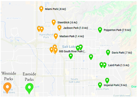
Figure 1.
Map of 10 parks selected from each region (Eastside and Westside), total of 20 parks.
A key geographic information strategy employed in this study was the creation of a half-mile buffer (approximately a 10 min walking distance) around each park (Figure 2). This radius served as the analytical unit for demographic and socioeconomic data collection based on the widely accepted urban planning principle that a half mile is a reasonable and equitable walking distance for most residents.
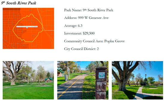
Figure 2.
Half-mile buffer (approximately a 10 min walking distance) around each park.
A combination of public and proprietary spatial datasets was utilized to develop a comprehensive demographic profile for each park: Social Explorer for American Community Survey (ACS 2015–2019) data at the census tract and block group levels; PolicyMap for housing costs, vacancy rates, affordability thresholds, and environmental quality indicators; and Zillow for neighborhood-level Z-estimates, median home values, and gross rents. Walk Score and Transit Score were also included to assess walkability and transit accessibility.
Indicators used included population density, age, gender, race/ethnicity, household income, educational attainment, housing tenure, poverty levels, Walk Score, Transit Score, percentage of residents who bike to work, and housing affordability thresholds using both cost/income ratios and the mean multiple method. Data were cleaned and compiled using standardized templates and analyzed via descriptive statistics, cross-tabulation, and visualization using Excel and GIS. Comparative analysis between the Eastside and Westside identified key spatial patterns of inequity in demographics, housing burden, and transportation access. Figure 3 presents a simplified overview of the methodological steps used in this study, from park selection and buffer creation to data collection, processing, and spatial equity analysis.
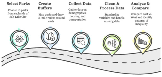
Figure 3.
Park analysis methodology.
4. Results
Table 1 presents key demographic and equity indicators for 20 neighborhood parks across Salt Lake City—10 on the Westside and 10 on the Eastside. The disparities between regions are stark. Parks located in Westside neighborhoods consistently exhibit lower median household incomes, with several under USD 50,000, compared to Eastside parks, which are surrounded by neighborhoods exceeding USD 100,000 in median income. Westside parks also show significantly higher rent burden, with some areas like Steenblik Park reaching over 50%, indicating housing stress for many residents.

Table 1.
Demographic and equity characteristics of 20 Salt Lake City parks.
The population around Westside parks is younger, with under-18 populations frequently above 30%, while Eastside parks tend to serve older, more established communities. Racial/ethnic disparities are also evident—Hispanic populations near Westside parks average above 40%, while Eastside parks are in areas that are predominantly white, with Hispanic percentages often below 10%.
Infrastructure measures further emphasize these differences. Walk Scores in Westside areas are consistently lower, indicating poorer pedestrian environments. Transit Scores are somewhat mixed but still generally higher near Eastside parks, suggesting better public transportation access. Together, these metrics highlight that residents in Westside neighborhoods face not only economic and housing challenges but also reduced mobility options when it comes to accessing park resources.
Findings from the spatial analysis show consistent disparities across multiple indicators. Westside parks are surrounded by neighborhoods with younger, more racially/ethnically diverse, and lower-income populations. Rent burden is higher in these areas, with some neighborhoods like Steenblik Park reporting rent-to-income ratios above 50%. Walk Scores were significantly lower for Westside parks—Miami Park scored just 20 compared to Richmond Park’s 91. Transit Scores showed slightly more parity but only in areas with major arterial roads. Eastside neighborhoods showed higher income, homeownership, and educational attainment levels. These patterns confirm a broader trend: lower-income neighborhoods not only are underserved in terms of park quality but also face literal geographic and infrastructural barriers to reaching them. Full park-by-park tables and figures illustrate the depth and distribution of these patterns.
Age distribution analysis revealed that Westside parks serve significantly younger populations. For example, Miami Park’s surrounding population included nearly 49% under the age of 18. Eastside parks like Taufer and Richmond showed higher concentrations of adults aged 65 and older, signaling the need for varied amenities by age cohort.
Gender composition varied slightly across parks, with Stratford Park on the Eastside showing a female majority (59.9%) and Miami Park on the Westside skewing male (56.5%).
Racial and ethnic disparities were especially pronounced. Westside parks had majority-Hispanic populations—Madsen Park and Miami Park at over 50%—while Eastside parks were over 90% white. These differences reflect the historical segregation of neighborhoods and impact the cultural relevance and accessibility of park programming.
Housing tenure analysis showed higher renter rates in parks like Taufer (86%) and Richmond (85.9%), while Eastside parks like Davis and Laird had the highest ownership rates. Median household income varied dramatically from USD 124,150 near Wasatch Hollow (Eastside) to USD 28,881 near Taufer Park (Westside). Renters near Steenblik Park spent over 50% of income on rent, highlighting severe housing cost burden.
Walk Scores confirmed a walkability gap: Richmond Park scored 91, while Miami Park scored just 20. Transit Scores varied but generally reflected better service on the Eastside, although Poplar Grove and Madsen Park were exceptions on the Westside with high scores.
Bicycling rates were low overall but highest near Wasatch Hollow and Modesto Park (9%). Car dependence was high in low-income Westside neighborhoods, while Eastside parks had higher private vehicle access and more alternative transportation options. These patterns reflect cumulative disadvantage and suggest a need for strategic investment aligned with demographic and environmental context.
5. Discussion
The findings in Table 1 confirm long-standing concerns about spatial equity and access to public green spaces. This study adds empirical support to the literature showing that communities of color and low-income residents are systematically underserved when it comes to access and infrastructure related to public parks [1,2,3,9,10,11,12]. Westside parks, while numerically equivalent to Eastside parks, are in neighborhoods with significantly higher rent burden, lower household income, and greater concentrations of Hispanic residents. These findings echo prior research on urban environmental justice and the need to consider the built environment in discussions of equity [4,9]. However, spatial access alone does not fully explain disparities in park usage. Systemic exclusion, cultural preferences, and historical disinvestment may also shape how residents perceive and use public parks. Factors such as perceived safety, cultural relevance of park programming, and trust in public institutions influence whether a park feels welcoming or exclusionary.
Where this study contributes is in applying a fine-grained, GIS-based methodology to a midsize U.S. city. Much of the existing literature focuses on large metro areas like Los Angeles, New York, or Chicago. This analysis demonstrates that inequities persist even in cities that may not receive as much national attention. Moreover, by combining demographic, housing, and transportation data within walkable park buffers, this research provides a replicable method for spatial equity auditing that local governments and planning departments can use elsewhere. This study also builds on calls in the literature for more actionable spatial analyses that can guide public investment toward historically excluded communities [5,7,9]. The emerging literature on cultural exclusion in urban public spaces points to the need for more context-sensitive planning that reflects the lived experiences of underserved communities.
Public lands and park agencies must shift from traditional one-size-fits-all models of investment to equity-driven frameworks that prioritize need and vulnerability. Targeted investments should focus on Westside parks where younger, more diverse, and more rent-burdened populations reside. Planning strategies should be tailored—for example, youth-oriented programming in Miami Park, accessibility upgrades for older adults in Taufer and Richmond Parks, and culturally responsive design for Hispanic communities in Madsen Park. To better inform these strategies, future research should incorporate qualitative and mixed-methods approaches to explore residents’ lived experiences, cultural values, and emotional connections to public space. Such approaches would complement GIS-based findings and ensure that park planning is not only data-driven but also community-grounded.
GIS tools were essential in identifying these disparities and should be further institutionalized in public lands planning. The use of demographic and environmental variables within a geospatial buffer allowed for a detailed understanding of localized needs. The synthesis of data from Social Explorer, Zillow, and PolicyMap offers a robust foundation for data-driven equity audits and participatory planning.
GeoAI represents the next frontier in this work. With machine learning- and AI-based tools, planners can anticipate usage trends, displacement risk, and infrastructure gaps in real time. This capacity for predictive modeling and scenario testing makes it possible to align investments not only with current need but also with projected demographic and environmental changes. To realize this vision, Salt Lake City should implement spatial equity audits, deepen community co-design efforts, and coordinate with housing and transportation agencies to ensure integrated, just planning outcomes.
This study demonstrates how spatial and demographic disparities shape unequal access to public parks in Salt Lake City, with Westside neighborhoods—home to more racially diverse, lower-income, and rent-burdened residents—facing compounded barriers to park access. Using GIS-based methods and publicly available datasets, we mapped inequities in walkability, transit, income, and racial composition within a half-mile buffer around 20 parks. While this case is grounded in Salt Lake City, the methodology is transferable and can be adapted for use in other urban contexts experiencing similar patterns of spatial inequity.
Moreover, by situating our findings within broader theoretical frameworks such as spatial justice, “just green enough” planning, and environmental inequity, this study contributes to ongoing efforts to make urban public space more inclusive and accessible. Addressing inequities in park access requires not only spatial analysis but also planning approaches that are culturally responsive and historically informed, ensuring that investments in green infrastructure benefit the communities who have been most systematically excluded.
6. Conclusions
This study finds compelling evidence that in Salt Lake City, the poorer the neighborhood, the harder it is to reach the park. By analyzing data from 20 neighborhood parks using GIS and demographic profiling, clear east–west disparities emerge in income, rent burden, walkability, racial and ethnic composition, and transit access. These inequities suggest that access to urban green space is a matter not only of proximity but also of broader social and infrastructural context.
Residents of Westside neighborhoods—who are more likely to be lower-income, renters, and members of communities of color—face multiple compounded challenges that limit their ability to benefit from public parks. In contrast, Eastside parks are more accessible and embedded in areas with greater wealth and stronger infrastructure.
The implications of these findings are clear: achieving spatial equity in park access requires more than equitable distribution of land. It requires thoughtful investment in transportation, pedestrian infrastructure, and inclusive planning processes that center historically underserved communities. GIS tools provide a powerful framework to diagnose and visualize these disparities and must be integrated into decision-making to ensure that future planning promotes just and sustainable access to public space for all residents.
These disparities are not isolated phenomena but rather are structural manifestations of broader patterns of urban inequality shaped by historical segregation, uneven investment, and policy decisions that have long privileged some communities over others. Residents of Westside neighborhoods are younger, more racially diverse, more likely to rent, and more severely rent-burdened than their Eastside counterparts, yet they face diminished park access due to poor walkability and transit infrastructure.
GIS provided the tools to identify, visualize, and interpret these inequities. Going forward, the integration of GeoAI technologies and real-time data can further advance equitable urban planning. A just and sustainable public parks system must be rooted in spatial justice, guided by local demographic realities, and co-created with communities most affected by disinvestment. Salt Lake City can lead in this arena by embedding equity into every step of its public lands planning process.
Funding
This research received no external funding.
Institutional Review Board Statement
Not applicable.
Informed Consent Statement
Not applicable.
Data Availability Statement
Data available upon request.
Acknowledgments
Thanks to students in the Westside Studio for collecting the data.
Conflicts of Interest
The author declares no conflicts of interest.
References
- Reed, J.A.; Price, A.E.; Grost, L.; Mantinan, K. Demographic Characteristics and Physical Activity Behaviors in Sixteen Michigan Parks. J Commun. Health 2012, 37, 507–512. [Google Scholar] [CrossRef] [PubMed]
- Hughey, S.M.; Walsemann, K.M.; Child, S.; Powers, A.; Reed, J.A.; Kaczynski, A.T. Spatial inequalities in child playground availability in the United States: A spatial analysis of park access and neighborhood demographic disparities. Int. J. Health Geogr. 2017, 16, 17. [Google Scholar] [CrossRef]
- Park, K.; García, I.; Kim, K. Who visited parks and trails more or less during the COVID-19 pandemic, and how? A mixed-methods study. Landsc. Res. Rec. 2023, 11, 157–171. [Google Scholar]
- Wolch, J.R.; Wilson, J.P.; Fehrenbach, J. Parks and park funding in Los Angeles: An equity-mapping analysis. Urban Geogr. 2005, 26, 4–35. [Google Scholar] [CrossRef]
- Ibes, D.C. A multi-criteria approach to mapping urban greenspace access for prioritizing planning efforts: A case study in Providence, Rhode Island. Cities 2015, 42, 119–128. [Google Scholar] [CrossRef]
- Maas, J.; Verheij, R.A.; Groenewegen, P.P.; de Vries, S.; Spreeuwenberg, P. Green space, urbanity, and health: How strong is the relation? J. Epidemiol. Commun. Health 2006, 60, 587–592. [Google Scholar] [CrossRef] [PubMed]
- Liu, H.; Li, F.; Li, J.; Zhang, Y. The relationships between urban parks, residents’ physical activity, and mental health benefits: A case study from Beijing, China. J. Environ. Manag. 2017, 190, 223–230. [Google Scholar] [CrossRef] [PubMed]
- Job, H.; Becken, S.; Lane, B. Protected areas in a neoliberal world and the role of tourism in supporting conservation and sustainable development: An assessment of strategic planning, zoning, impact monitoring, and tourism management at natural World Heritage Sites. J. Sustain. Tour. 2017, 25, 1697–1718. [Google Scholar] [CrossRef]
- Wolch, J.R.; Byrne, J.; Newell, J.P. Urban green space, public health, and environmental justice: The challenge of making cities ‘just green enough’. Landsc. Urban Plan. 2014, 125, 234–244. [Google Scholar] [CrossRef]
- Maroko, A.R.; Maantay, J.A.; Sohler, N.L.; Grady, K.L.; Arno, P.S. The complexities of measuring access to parks and physical activity sites in New York City: A quantitative and qualitative approach. Int. J. Health Geogr. 2009, 8, 34. [Google Scholar] [CrossRef] [PubMed]
- Cutts, B.B.; Darby, K.J.; Boone, C.G.; Brewis, A. City structure, obesity, and environmental justice: An integrated analysis of physical and social barriers to walkable streets and park access. Soc. Sci. Med. 2009, 69, 1314–1322. [Google Scholar] [CrossRef] [PubMed]
- Vaughan, K.B.; Kaczynski, A.T.; Wilhelm Stanis, S.A.; Besenyi, G.M.; Bergstrom, R.D.; Heinrich, K.M. Exploring the distribution of park availability, features, and quality across Kansas City, Missouri by income and race/ethnicity: An environmental justice investigation. Ann. Behav. Med. 2013, 45, S28–S38. [Google Scholar] [CrossRef] [PubMed]
- Worku, H.; Muchie, M.; Lette, K.; Ambelu, A. Spatial accessibility analysis of urban green spaces and parks in Addis Ababa, Ethiopia. Urban For. Urban Green. 2020, 54, 126768. [Google Scholar] [CrossRef]
- Heo, S.; Desai, M.U.; Lowe, S.R.; Bell, M.L. Impact of neighborhood social cohesion and park access on mental health: A longitudinal analysis of the health and retirement study. Environ. Int. 2019, 130, 104912. [Google Scholar] [CrossRef]
- Ferrara, E.; Interdonato, R.; Tagarelli, A. Online popularity and topical interests through the lens of Instagram. In Proceedings of the 25th ACM Conference Hypertext Social Media, Santiago, Chile, 1–4 September 2014; pp. 24–34. [Google Scholar] [CrossRef]
- Mowen, A.J.; Payne, L.L.; Scott, D. Change and stability in park visitation constraints revisited. Leis. Sci. 2005, 27, 191–204. [Google Scholar] [CrossRef]


Disclaimer/Publisher’s Note: The statements, opinions and data contained in all publications are solely those of the individual author(s) and contributor(s) and not of MDPI and/or the editor(s). MDPI and/or the editor(s) disclaim responsibility for any injury to people or property resulting from any ideas, methods, instructions or products referred to in the content. |
© 2025 by the author. Licensee MDPI, Basel, Switzerland. This article is an open access article distributed under the terms and conditions of the Creative Commons Attribution (CC BY) license (https://creativecommons.org/licenses/by/4.0/).