Using Time Series Sentinel Images for Object-Oriented Crop Extraction of Planting Structure in the Google Earth Engine
Abstract
:1. Introduction
2. Materials and Methods
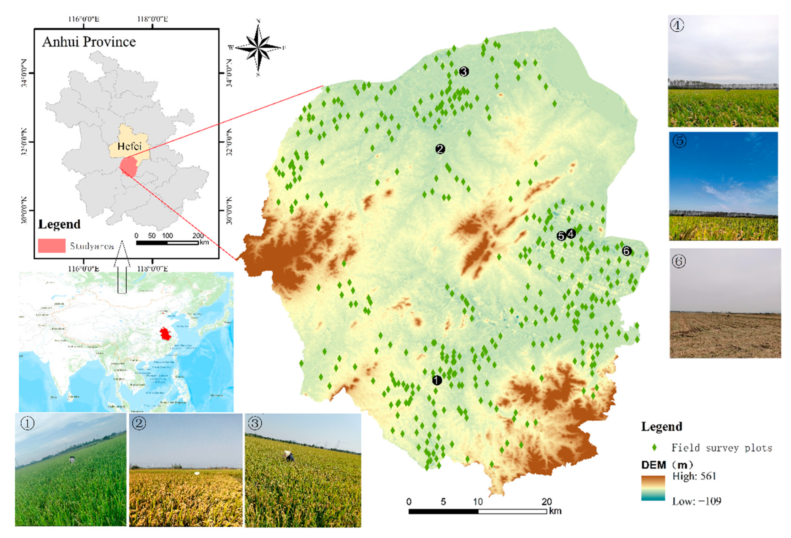
2.1. Study Area
2.2. Sample Point Data
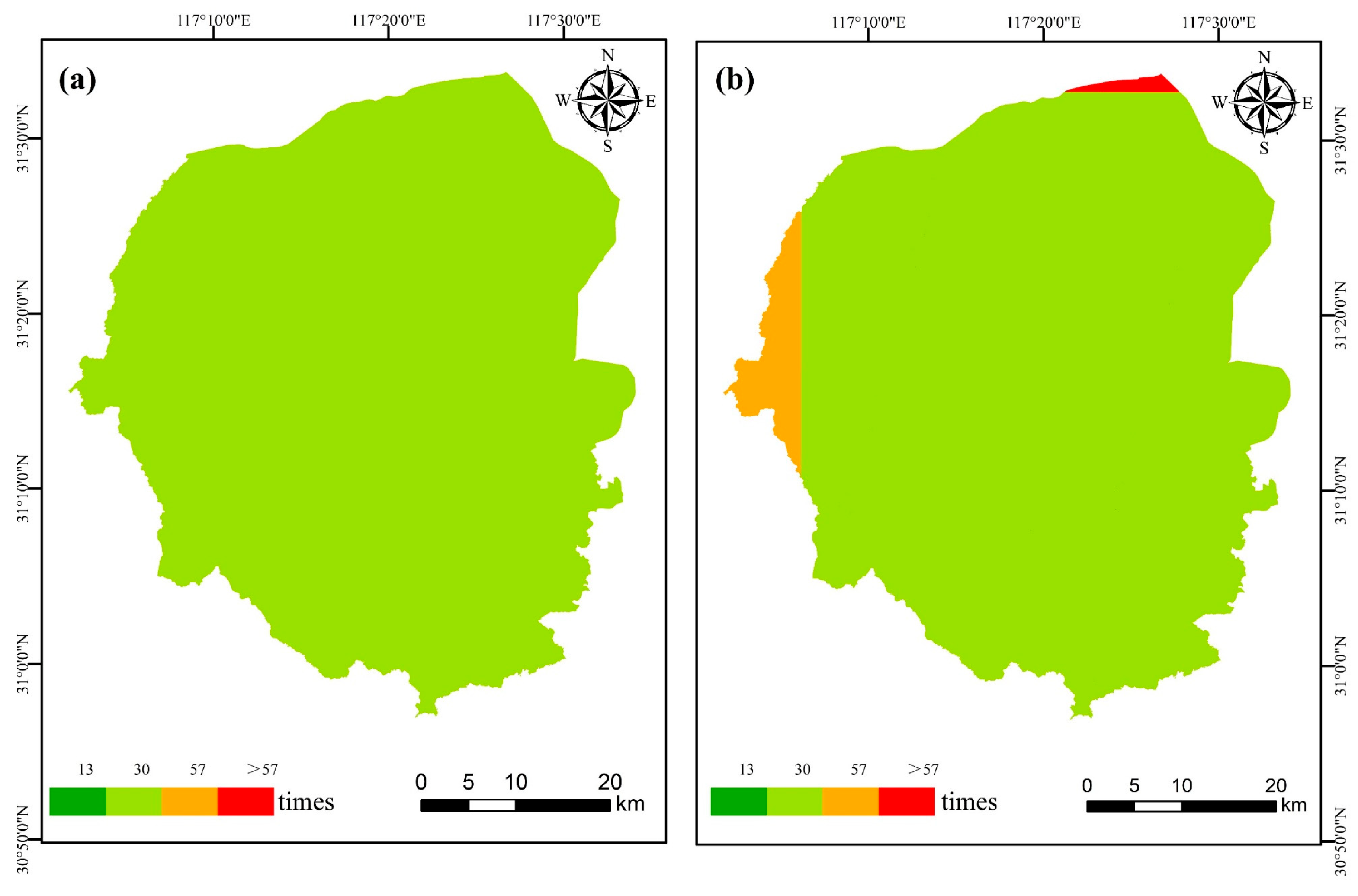
2.3. Remote Sensing Data
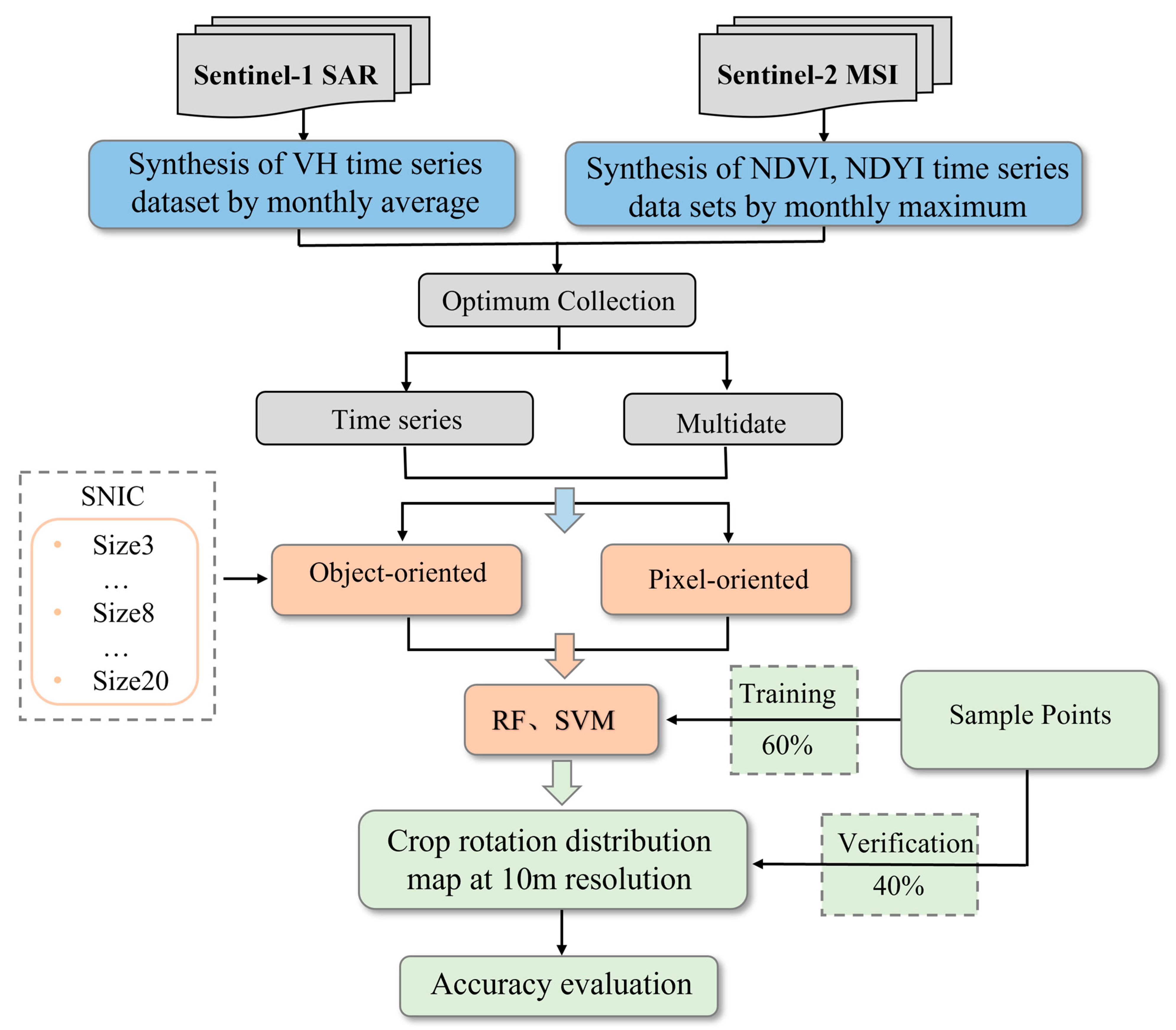
2.4. The Planting Structure Extraction Method
2.4.1. Constructing the Feature Dataset
2.4.2. Simple Non-Iterative Clustering
2.4.3. The Planting Structure Extraction Algorithm
2.5. Accuracy Evaluation
3. Result Analysis
3.1. The Optimal Feature Set
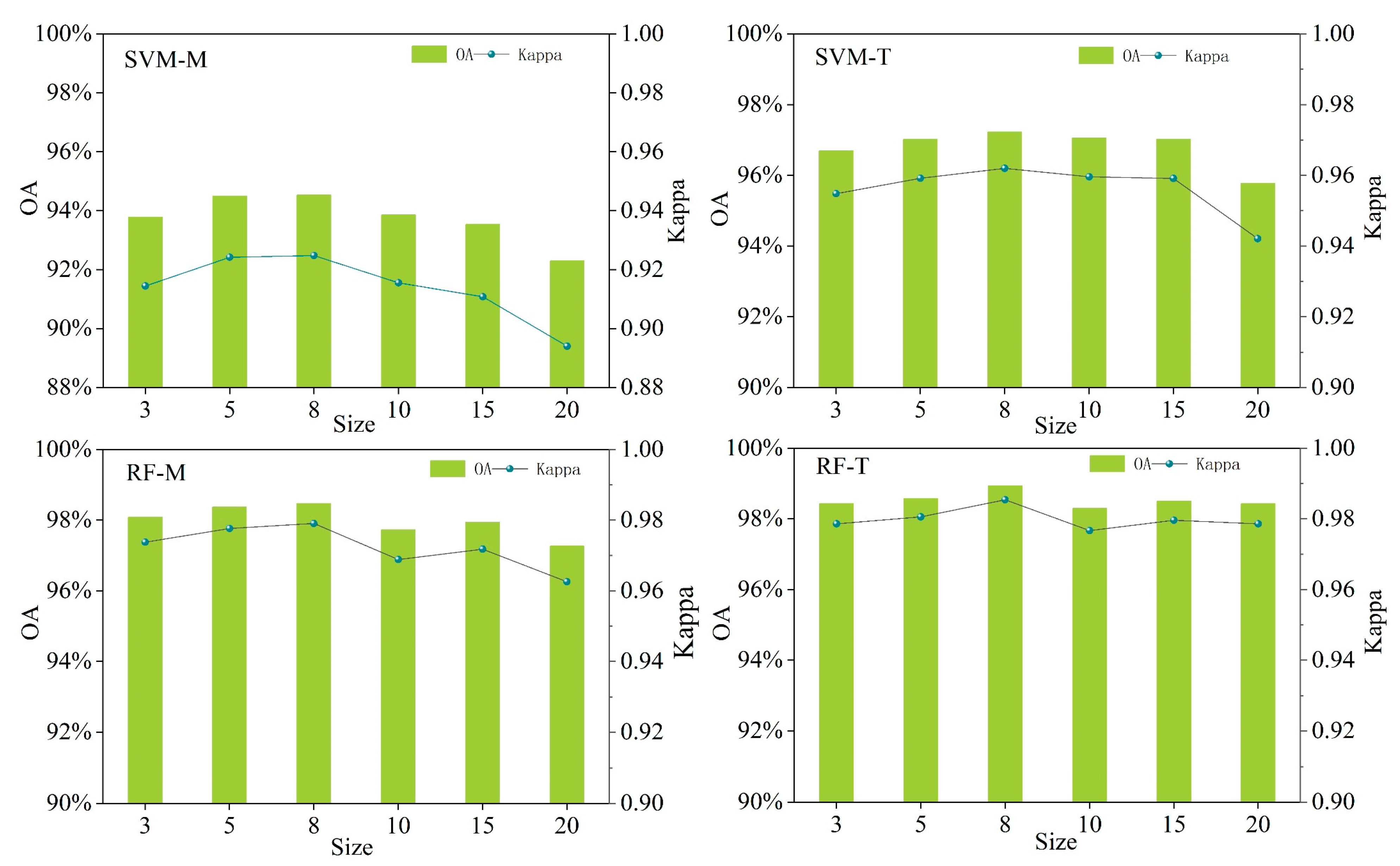
3.2. Optimal Seed Pixel Spacing
3.3. Extraction Results and Precision Analysis
4. Discussion
4.1. The Potential of OB + T + RF to Extract Complex Crop Rotation Patterns
4.2. Advantages of Feature Construction and Extraction on the GEE Platform
4.3. The Limitation of the Algorithm and the Uncertainty of the Segmentation Scale
5. Conclusions
- (1)
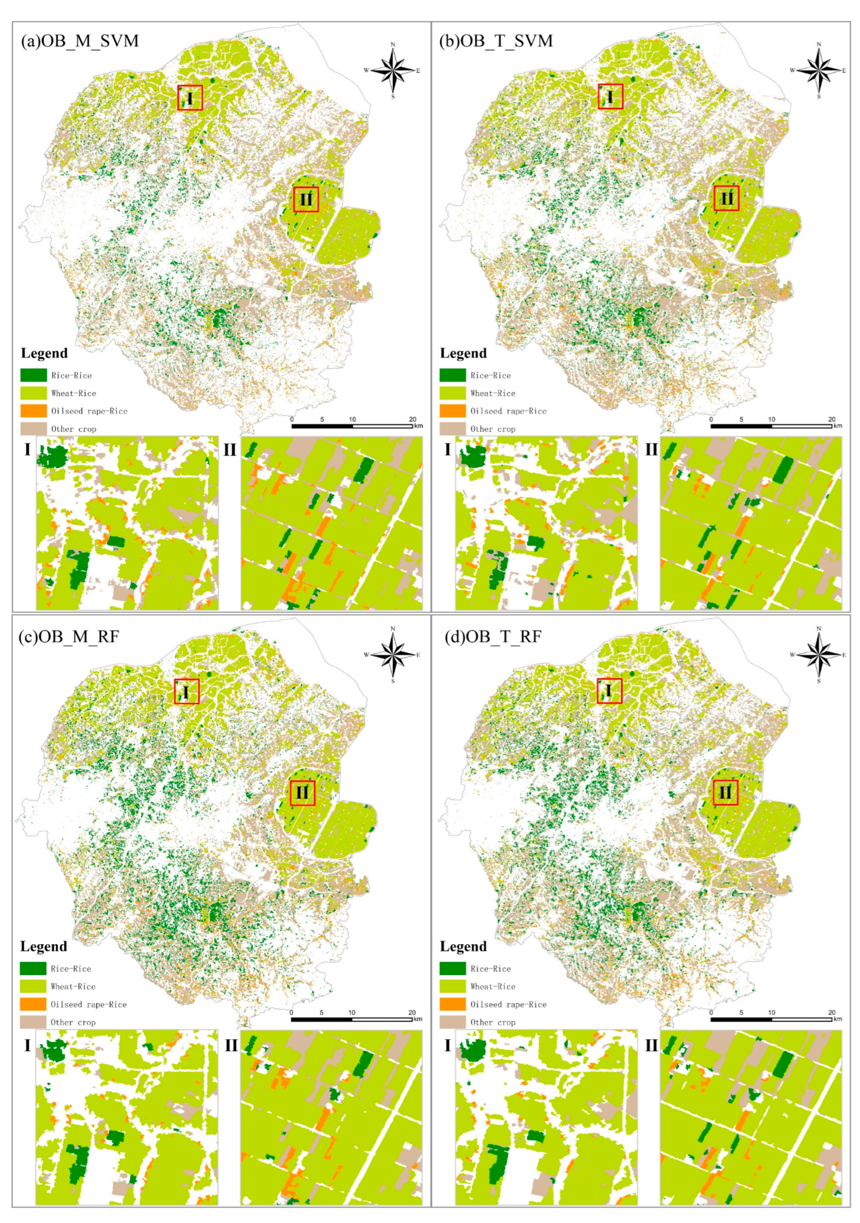
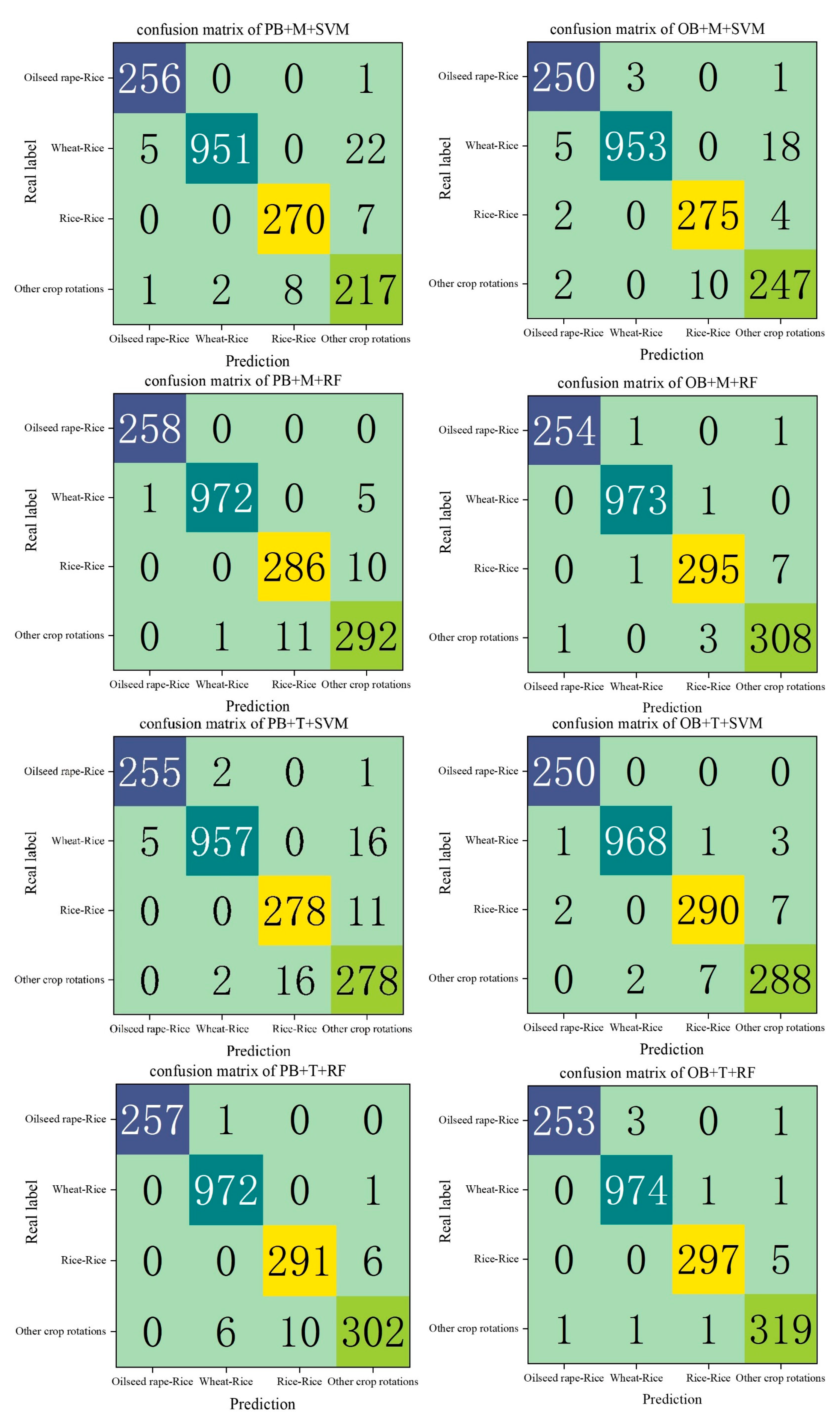
- The optimal extraction model was OB + T + RF and the overall accuracy and Kappa coefficient were 98.93% and 0.9854, respectively. The extraction accuracy of the model constructed by the RF algorithm was higher than that of the model constructed by the SVM algorithm.
- (2)
- The GEE platform can be used to extract high-efficiency and high-precision crop planting structure information. The GEE platform can directly call Sentinel data with high temporal resolution and high spatial resolution; at the same time, it also has a strong cloud computing capability, which can quickly conduct image preprocessing, build feature index and time series datasets, and extract crop planting structure information.
- (3)
- When crop planting structure information is extracted at a 10 m spatial resolution, the accuracy of the object-oriented extraction method is higher than that of the pixel-based extraction method.
- (4)
- The extraction accuracy of time series data is higher than that of multi-temporal data, and time series data can better reflect the characteristics of each stage of crop growth, and high-precision crop planting structure information can be extracted with less phenological information.
Author Contributions
Funding
Data Availability Statement
Acknowledgments
Conflicts of Interest
References
- Li, H.; Song, X.-P.; Hansen, M.C.; Becker-Reshef, I.; Adusei, B.; Pickering, J.; Wang, L.; Wang, L.; Lin, Z.; Zalles, V.; et al. Development of a 10-m resolution maize and soybean map over China: Matching satellite-based crop classification with sample-based area estimation. Remote Sens. Environ. 2023, 294, 113623. [Google Scholar] [CrossRef]
- Garajeh, M.K.; Salmani, B.; Naghadehi, S.Z.; Goodarzi, H.V.; Khasraei, A. An integrated approach of remote sensing and geospatial analysis for modeling and predicting the impacts of climate change on food security. Sci. Rep. 2023, 13, 1057. [Google Scholar] [CrossRef] [PubMed]
- Di, Y.; Zhang, G.; You, N.; Yang, T.; Zhang, Q.; Liu, R.; Doughty, R.B.; Zhang, Y. Mapping Croplands in the Granary of the Tibetan Plateau Using All Available Landsat Imagery, A Phenology-Based Approach, and Google Earth Engine. Remote Sens. 2021, 13, 2289. [Google Scholar] [CrossRef]
- Jin, Z.; Azzari, G.; You, C.; Di Tommaso, S.; Aston, S.; Burke, M.; Lobell, D.B. Smallholder maize area and yield mapping at national scales with Google Earth Engine. Remote Sens. Environ. 2019, 228, 115–128. [Google Scholar] [CrossRef]
- Donohue, R.J.; Lawes, R.A.; Mata, G.; Gobbett, D.; Ouzman, J. Towards a national, remote-sensing-based model for predicting field-scale crop yield. Field Crops Res. 2018, 227, 79–90. [Google Scholar] [CrossRef]
- Wang, X.; Fang, S.; Yang, Y.; Du, J.; Wu, H. A New Method for Crop Type Mapping at the Regional Scale Using Multi-Source and Multi-Temporal Sentinel Imagery. Remote Sens. 2023, 15, 2466. [Google Scholar] [CrossRef]
- Weiss, M.; Jacob, F.; Duveiller, G. Remote sensing for agricultural applications: A meta-review. Remote Sens. Environ. 2020, 236, 111402. [Google Scholar] [CrossRef]
- Franch, B.; Vermote, E.F.; Skakun, S.; Roger, J.C.; Becker-Reshef, I.; Murphy, E.; Justice, C. Remote sensing based yield monitoring: Application to winter wheat in United States and Ukraine. Int. J. Appl. Earth Obs. Geoinf. 2019, 76, 112–127. [Google Scholar] [CrossRef]
- Becker-Reshef, I.; Justice, C.; Barker, B.; Humber, M.; Rembold, F.; Bonifacio, R.; Zappacosta, M.; Budde, M.; Magadzire, T.; Shitote, C.; et al. Strengthening agricultural decisions in countries at risk of food insecurity: The GEOGLAM Crop Monitor for Early Warning. Remote Sens. Environ. 2020, 237, 111553. [Google Scholar] [CrossRef]
- Cai, Y.; Guan, K.; Peng, J.; Wang, S.; Seifert, C.; Wardlow, B.; Li, Z. A high-performance and in-season classification system of field-level crop types using time-series Landsat data and a machine learning approach. Remote Sens. Environ. 2018, 210, 35–47. [Google Scholar] [CrossRef]
- Tian, G.; Li, H.; Jiang, Q.; Qiao, B.; Li, N.; Guo, Z.; Zhao, J.; Yang, H. An Automatic Method for Rice Mapping Based on Phenological Features with Sentinel-1 Time-Series Images. Remote Sens. 2023, 15, 2785. [Google Scholar] [CrossRef]
- Conese, C.; Maselli, F. Use of multitemporal information to improve classification performance of TM scenes in complex terrain. ISPRS J. Photogramm. Remote Sens. 1991, 46, 187–197. [Google Scholar] [CrossRef]
- Khatami, R.; Mountrakis, G.; Stehman, S.V. A meta-analysis of remote sensing research on supervised pixel-based land-cover image classification processes: General guidelines for practitioners and future research. Remote Sens. Environ. 2016, 177, 89–100. [Google Scholar] [CrossRef]
- Orynbaikyzy, A.; Gessner, U.; Conrad, C. Crop type classification using a combination of optical and radar remote sensing data: A review. Int. J. Remote Sens. 2019, 40, 6553–6595. [Google Scholar] [CrossRef]
- Wang, M.; Wang, J.; Cui, Y.; Liu, J.; Chen, L. Agricultural Field Boundary Delineation with Satellite Image Segmentation for High-Resolution Crop Mapping: A Case Study of Rice Paddy. Agronomy 2022, 12, 2342. [Google Scholar] [CrossRef]
- Jia, K.; Wu, B.; Li, Q. Crop classification using HJ satellite multispectral data in the North China Plain. J. Appl. Remote Sens. 2013, 7, 073576. [Google Scholar] [CrossRef]
- Larranaga, A.; Alvarez-Mozos, J. On the Added Value of Quad-Pol Data in a Multi-Temporal Crop Classification Framework Based on RADARSAT-2 Imagery. Remote Sens. 2016, 8, 335. [Google Scholar] [CrossRef]
- Whelen, T.; Siqueira, P. Use of time-series L-band UAVSAR data for the classification of agricultural fields in the San Joaquin Valley. Remote Sens. Environ. 2017, 193, 216–224. [Google Scholar] [CrossRef]
- Hao, P.; Wang, L.; Niu, Z.; Aablikim, A.; Huang, N.; Xu, S.; Chen, F. The Potential of Time Series Merged from Landsat-5 TM and HJ-1 CCD for Crop Classification: A Case Study for Bole and Manas Counties in Xinjiang, China. Remote Sens. 2014, 6, 7610–7631. [Google Scholar] [CrossRef]
- Zhan, Y.; Muhammad, S.; Hao, P.; Niu, Z. The effect of EVI time series density on crop classification accuracy. Optik 2018, 157, 1065–1072. [Google Scholar] [CrossRef]
- Kang, Y.; Hu, X.; Meng, Q.; Zou, Y.; Zhang, L.; Liu, M.; Zhao, M. Land Cover and Crop Classification Based on Red Edge Indices Features of GF-6 WFV Time Series Data. Remote Sens. 2021, 13, 4522. [Google Scholar] [CrossRef]
- Wardlow, B.D.; Egbert, S.L. Large-area crop mapping using time-series MODIS 250 m NDVI data: An assessment for the US Central Great Plains. Remote Sens. Environ. 2008, 112, 1096–1116. [Google Scholar] [CrossRef]
- Sakamoto, T.; Yokozawa, M.; Toritani, H.; Shibayama, M.; Ishitsuka, N.; Ohno, H. A crop phenology detection method using time-series MODIS data. Remote Sens. Environ. 2005, 96, 366–374. [Google Scholar] [CrossRef]
- Hao, P.; Zhan, Y.; Wang, L.; Niu, Z.; Shakir, M. Feature Selection of Time Series MODIS Data for Early Crop Classification Using Random Forest: A Case Study in Kansas, USA. Remote Sens. 2015, 7, 5347–5369. [Google Scholar] [CrossRef]
- Phan Thanh, N.; Kappas, M. Comparison of Random Forest, k-Nearest Neighbor, and Support Vector Machine Classifiers for Land Cover Classification Using Sentinel-2 Imagery. Sensors 2018, 18, 18. [Google Scholar] [CrossRef]
- Liu, L.; Xiao, X.; Qin, Y.; Wang, J.; Xu, X.; Hu, Y.; Qiao, Z. Mapping cropping intensity in China using time series Landsat and Sentinel-2 images and Google Earth Engine. Remote Sens. Environ. 2020, 239, 111624. [Google Scholar] [CrossRef]
- Ni, R.; Tian, J.; Li, X.; Yin, D.; Li, J.; Gong, H.; Zhang, J.; Zhu, L.; Wu, D. An enhanced pixel-based phenological feature for accurate paddy rice mapping with Sentinel-2 imagery in Google Earth Engine. ISPRS J. Photogramm. Remote Sens. 2021, 178, 282–296. [Google Scholar] [CrossRef]
- Ashourloo, D.; Shahrabi, H.S.; Azadbakht, M.; Rad, A.M.; Aghighi, H.; Radiom, S. A novel method for automatic potato mapping using time series of Sentinel-2 images. Comput. Electron. Agric. 2020, 175, 105583. [Google Scholar] [CrossRef]
- Jiang, Q.; Tang, Z.; Zhou, L.; Hu, G.; Deng, G.; Xu, M.; Sang, G. Mapping Paddy Rice Planting Area in Dongting Lake Area Combining Time Series Sentinel-1 and Sentinel-2 Images. Remote Sens. 2023, 15, 2794. [Google Scholar] [CrossRef]
- Yang, L.; Wang, L.; Abubakar, G.A.; Huang, J. High-Resolution Rice Mapping Based on SNIC Segmentation and Multi-Source Remote Sensing Images. Remote Sens. 2021, 13, 1148. [Google Scholar] [CrossRef]
- Saad El Imanni, H.; El Harti, A.; Hssaisoune, M.; Velastegui-Montoya, A.; Elbouzidi, A.; Addi, M.; El Iysaouy, L.; El Hachimi, J. Rapid and Automated Approach for Early Crop Mapping Using Sentinel-1 and Sentinel-2 on Google Earth Engine; A Case of a Highly Heterogeneous and Fragmented Agricultural Region. J. Imaging 2022, 8, 316. [Google Scholar] [CrossRef] [PubMed]
- Fatchurrachman; Rudiyanto; Soh, N.C.; Shah, R.M.; Giap, S.G.E.; Setiawan, B.I.; Minasny, B. High-Resolution Mapping of Paddy Rice Extent and Growth Stages across Peninsular Malaysia Using a Fusion of Sentinel-1 and 2 Time Series Data in Google Earth Engine. Remote Sens. 2022, 14, 1875. [Google Scholar] [CrossRef]
- Wang, Y.Y.; Fang, S.H.; Zhao, L.L.; Huang, X.X.; Jiang, X.Q. Parcel-based summer maize mapping and phenology estimation combined using Sentinel-2 and time series Sentinel-1 data. Int. J. Appl. Earth Obs. Geoinf. 2022, 108, 102720. [Google Scholar] [CrossRef]
- Maiti, A.; Acharya, P.; Sannigrahi, S.; Zhang, Q.; Bar, S.; Chakraborti, S.; Gayen, B.K.; Barik, G.; Ghosh, S.; Punia, M. Mapping active paddy rice area over monsoon asia using time-series Sentinel-2 images in Google earth engine; a case study over lower gangetic plain. Geocarto Int. 2022, 37, 10254–10277. [Google Scholar] [CrossRef]
- Xing, H.Q.; Chen, B.Y.; Feng, Y.Y.; Ni, Y.L.; Hou, D.Y.; Wang, X.; Kong, Y.W. Mapping irrigated, rainfed and paddy croplands from time-series Sentinel-2 images by integrating pixel-based classification and image segmentation on Google Earth Engine. Geocarto Int. 2022, 37, 13291–13310. [Google Scholar] [CrossRef]
- Xue, H.; Xu, X.; Zhu, Q.; Yang, G.; Long, H.; Li, H.; Yang, X.; Zhang, J.; Yang, Y.; Xu, S.; et al. Object-Oriented Crop Classification Using Time Series Sentinel Images from Google Earth Engine. Remote Sens. 2023, 15, 1353. [Google Scholar] [CrossRef]
- Li, M.; Zhang, R.; Luo, H.; Gu, S.; Qin, Z. Crop Mapping in the Sanjiang Plain Using an Improved Object-Oriented Method Based on Google Earth Engine and Combined Growth Period Attributes. Remote Sens. 2022, 14, 273. [Google Scholar] [CrossRef]
- Luo, C.; Qi, B.S.; Liu, H.J.; Guo, D.; Lu, L.P.; Fu, Q.; Shao, Y.Q. Using Time Series Sentinel-1 Images for Object-Oriented Crop Classification in Google Earth Engine. Remote Sens. 2021, 13, 561. [Google Scholar] [CrossRef]
- Zamani-Noor, N.; Feistkorn, D. Monitoring Growth Status of Winter Oilseed Rape by NDVI and NDYI Derived from UAV-Based Red-Green-Blue Imagery. Agronomy 2022, 12, 2212. [Google Scholar] [CrossRef]
- Duy Ba, N.; Gruber, A.; Wagner, W. Mapping rice extent and cropping scheme in the Mekong Delta using Sentinel-1A data. Remote Sens. Lett. 2016, 7, 1209–1218. [Google Scholar] [CrossRef]
- Achanta, R.; Shaji, A.; Smith, K.; Lucchi, A.; Fua, P.; Suesstrunk, S. SLIC Superpixels Compared to State-of-the-Art Superpixel Methods. IEEE Trans. Pattern Anal. Mach. Intell. 2012, 34, 2274–2281. [Google Scholar] [CrossRef] [PubMed]
- Pal, M. Random forest classifier for remote sensing classification. Int. J. Remote Sens. 2005, 26, 217–222. [Google Scholar] [CrossRef]
- Rodriguez-Galiano, V.F.; Ghimire, B.; Rogan, J.; Chica-Olmo, M.; Rigol-Sanchez, J.P. An assessment of the effectiveness of a random forest classifier for land-cover classification. ISPRS J. Photogramm. Remote Sens. 2012, 67, 93–104. [Google Scholar] [CrossRef]
- Park, S.; Im, J.; Park, S.; Yoo, C.; Han, H.; Rhee, J. Classification and Mapping of Paddy Rice by Combining Landsat and SAR Time Series Data. Remote Sens. 2018, 10, 447. [Google Scholar] [CrossRef]
- Pal, M.; Mather, P.M. Support vector machines for classification in remote sensing. Int. J. Remote Sens. 2005, 26, 1007–1011. [Google Scholar] [CrossRef]
- Kok, Z.H.; Shariff, A.R.M.; Alfatni, M.S.M.; Khairunniza-Bejo, S. Support Vector Machine in Precision Agriculture: A review. Comput. Electron. Agric. 2021, 191, 106546. [Google Scholar] [CrossRef]
- Jia, Y.; Zhang, X.; Zhang, H.; Su, Z. Crop Classification Based on A Gaofen 1/Wide-Field-View Time Series. Eng. Agric. 2022, 42. [Google Scholar] [CrossRef]
- Cheng, G.; Xie, X.; Han, J.; Guo, L.; Xia, G.-S. Remote Sensing Image Scene Classification Meets Deep Learning: Challenges, Methods, Benchmarks, and Opportunities. IEEE J. Sel. Top. Appl. Earth Obs. Remote Sens. 2020, 13, 3735–3756. [Google Scholar] [CrossRef]
- Sun, X.; Wang, B.; Wang, Z.; Li, H.; Li, H.; Fu, K. Research Progress on Few-Shot Learning for Remote Sensing Image Interpretation. Ieee J. Sel. Top. Appl. Earth Obs. Remote Sens. 2021, 14, 2387–2402. [Google Scholar] [CrossRef]
- Jiang, H.; Peng, M.; Zhong, Y.; Xie, H.; Hao, Z.; Lin, J.; Ma, X.; Hu, X. A Survey on Deep Learning-Based Change Detection from High-Resolution Remote Sensing Images. Remote Sens. 2022, 14, 1552. [Google Scholar] [CrossRef]




| Number | Sensor | Date | Quantity | Number | Sensor | Date | Quantity |
|---|---|---|---|---|---|---|---|
| 1 | S2 | October 2020 | 10 | 14 | S1GRD | October 2020 | 3 |
| 2 | S2 | November 2020 | 12 | 15 | S1GRD | November 2020 | 2 |
| 3 | S2 | December 2020 | 12 | 16 | S1GRD | December 2020 | 3 |
| 4 | S2 | January 2021 | 7 | 17 | S1GRD | January 2021 | 2 |
| 5 | S2 | February 2021 | 3 | 18 | S1GRD | February 2021 | 3 |
| 6 | S2 | March 2021 | 6 | 19 | S1GRD | March 2021 | 2 |
| 7 | S2 | April 2021 | 5 | 20 | S1GRD | April 2021 | 3 |
| 8 | S2 | May 2021 | 8 | 21 | S1GRD | May 2021 | 2 |
| 9 | S2 | June 2021 | 5 | 22 | S1GRD | June 2021 | 3 |
| 10 | S2 | July 2021 | 8 | 23 | S1GRD | July 2021 | 2 |
| 11 | S2 | August 2021 | 8 | 24 | S1GRD | August 2021 | 3 |
| 12 | S2 | September 2021 | 15 | 25 | S1GRD | September 2021 | 2 |
| 13 | S2 | October 2021 | 11 | 26 | S1GRD | October 2021 | 3 |
| Model | Kappa Coefficient | Overall Accuracy | Crop Rotation Pattern | Producer’s Accuracy | User’s Accuracy |
|---|---|---|---|---|---|
| PB 1 + M 2 + SVM 3 | 0.9008 | 92.79% | Wheat–Rice | 81.58% | 66.16% |
| Rice–Rice | 95.07% | 88.82% | |||
| Oilseed Rape–Rice | 99.48% | 97.14% | |||
| PB + M + RF 4 | 0.9645 | 97.41% | Wheat–Rice | 94.19% | 89.02% |
| Rice–Rice | 94.70% | 94.08% | |||
| Oilseed Rape–Rice | 99.69% | 99.28% | |||
| PB + T 5 + SVM | 0.9470 | 96.13% | Wheat–Rice | 88.82% | 84.76% |
| Rice–Rice | 94.24% | 91.45% | |||
| Oilseed Rape–Rice | 99.58% | 97.75% | |||
| PB + T + RF | 0.9733 | 98.05% | Wheat–Rice | 94.38% | 92.07% |
| Rice–Rice | 97.00% | 95.72% | |||
| Oilseed Rape–Rice | 99.69% | 99.28% | |||
| OB 6 + M + SVM | 0.9248 | 94.53% | Wheat–Rice | 89.49% | 75.30% |
| Rice–Rice | 96.15% | 90.46% | |||
| Oilseed Rape–Rice | 99.48% | 97.34% | |||
| OB + M + RF | 0.9791 | 98.47% | Wheat–Rice | 96.55% | 93.90% |
| Rice–Rice | 98.66% | 97.04% | |||
| Oilseed Rape–Rice | 99.69% | 99.39% | |||
| OB + T + SVM | 0.9620 | 97.23% | Wheat–Rice | 96.00% | 87.80% |
| Rice–Rice | 96.67% | 95.39% | |||
| Oilseed Rape–Rice | 99.69% | 98.88% | |||
| OB + T + RF | 0.9854 | 98.93% | Wheat–Rice | 97.26% | 97.26% |
| Rice–Rice | 99.33% | 97.70% | |||
| Oilseed Rape–Rice | 99.49% | 99.49% |
Disclaimer/Publisher’s Note: The statements, opinions and data contained in all publications are solely those of the individual author(s) and contributor(s) and not of MDPI and/or the editor(s). MDPI and/or the editor(s) disclaim responsibility for any injury to people or property resulting from any ideas, methods, instructions or products referred to in the content. |
© 2023 by the authors. Licensee MDPI, Basel, Switzerland. This article is an open access article distributed under the terms and conditions of the Creative Commons Attribution (CC BY) license (https://creativecommons.org/licenses/by/4.0/).
Share and Cite
Zhang, D.; Ying, C.; Wu, L.; Meng, Z.; Wang, X.; Ma, Y. Using Time Series Sentinel Images for Object-Oriented Crop Extraction of Planting Structure in the Google Earth Engine. Agronomy 2023, 13, 2350. https://doi.org/10.3390/agronomy13092350
Zhang D, Ying C, Wu L, Meng Z, Wang X, Ma Y. Using Time Series Sentinel Images for Object-Oriented Crop Extraction of Planting Structure in the Google Earth Engine. Agronomy. 2023; 13(9):2350. https://doi.org/10.3390/agronomy13092350
Chicago/Turabian StyleZhang, Daiwei, Chunyang Ying, Lei Wu, Zhongqiu Meng, Xiaofei Wang, and Youhua Ma. 2023. "Using Time Series Sentinel Images for Object-Oriented Crop Extraction of Planting Structure in the Google Earth Engine" Agronomy 13, no. 9: 2350. https://doi.org/10.3390/agronomy13092350
APA StyleZhang, D., Ying, C., Wu, L., Meng, Z., Wang, X., & Ma, Y. (2023). Using Time Series Sentinel Images for Object-Oriented Crop Extraction of Planting Structure in the Google Earth Engine. Agronomy, 13(9), 2350. https://doi.org/10.3390/agronomy13092350


