Abstract
This study conducted an extensive literature review spanning from 1950 to 2023, exploring the methodologies in urban geomorphology and urban geoheritage assessment, and the possibility of applying Nature-Based Solutions (NbSs) in order to enhance geomorphological maps. The methodology proposed here is based on a two-step approach: (i) a bibliographic review and methodological investigation and (ii) methodological proposal in order to enhance the traditional geomorphological and geoheritage maps with NbS to reduce the geomorphological risk in urban areas. This paper aims to introduce a methodological framework and illustrated its practical application to provide researchers and practitioners with a clear understanding of its implementation in real-world scenarios. The proposed methodology was applied in the north and northeastern parts of Milan, Italy. The implementation of the proposed methodology demonstrated its effectiveness in urban contexts and its potential for further modification and extension to various urban environments in the future.
1. Introduction
Urban geomorphology explores the intricate relationships between geomorphological processes and urbanization development by analyzing the relationship between humans and landscapes [1]. Urban geomorphology studies examine how natural landscapes undergo physical alterations due to human activities, leading to the creation of anthropogenic urban environments [2].
The rapid urbanization process significantly alters the configuration of our cities, leading to notable shifts in global Land Use Land Cover (LULC) patterns. Land use, as defined by Barnsley et al. [3], predominantly encompasses the human activities conducted on or in connection with a specific land area, including residential, commercial, industrial, or recreational purpose areas. This transformation involves not only the expansion of urban infrastructure but also extensive modifications of natural elements, such as rivers and slopes, that are impacted by human development in urban areas [4]. Consequently, this dynamic transformation introduces considerable complexity into the field of urban geomorphology, entailing in-depth scholarly investigations and analyses.
The urban environment, characterized by its complex landforms shaped by human activities, incorporates urban geoheritage, representing specific landforms enriched with historical and cultural significance. Urban geoheritage holds cultural significance due to its ability to reflect the historical development of human settlements and their interaction with the natural environment [5,6]. Urban geoheritage sites can be integrated into cultural heritage preservation efforts, contributing to the overall cultural landscape of a city. Therefore, recognizing the cultural dimension of urban geoheritage is essential for understanding its full significance within urban environments [5,7,8]. The inclusion of urban geoheritage in some urban geomorphological studies [9] and the development of methodologies [10] for its study have not been performed in many cases. Urban geomorphology should incorporate an urban geoheritage assessment to systematically evaluate and protect the cultural and natural assets represented by urban landforms and features shaped by natural processes within cities. Geoheritage is the term for the valuable geological and geomorphological components of the landscape that should be preserved [1,7,11,12,13,14,15]. Urban geoheritage refers to the collection of distinctive geological features, ongoing geological processes, and elements of the geological environment within urban areas and their immediate surroundings. These elements hold significance for contemporary society due to their scientific, cultural, and touristic value [7,11,16,17,18,19]. Detailed cartographic representations are fundamental tools for identifying, documenting, and managing the significant features of urban geomorphological heritage. For instance, Figure 1 displays a map of Milan in 1832, serving as a valuable historical document illustrating the layout of the city during that time period.
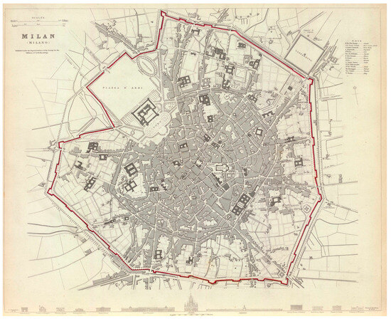
Figure 1.
Map of Milan in 1832 [20]. The Spanish walls are depicted on the map as a red line, and the main buildings are illustrated in the darker color. In the top right corner of the map, the annotations provide information about the elements represented on the map.
Specifically, the depiction of the Spanish walls marked with a red line highlights their significance as a prominent feature of the city’s urban landscape. Additionally, the detailed portrayal of the main buildings in the darker color provides insights into the architectural landscape of Milan in the early 19th century, enriching our understanding of its historical development. Thus, historically, the inclusion of urban geoheritage features in urban planning and city mapping illuminates the city’s landscape and enhances its spatial organization.
Geomorphological mapping plays an important role in guiding territorial planning and promoting sustainable land use in urban areas [21]. These maps are essential tools for urban land planning, showing information on active or inactive processes and landforms, bedrock lithology, deposits, and other territorial elements. In addition, the elements shown in the geomorphological maps are necessary for evaluating land suitability for diverse purposes, guiding sustainable land use decisions beyond hazard mitigation, and informing strategic urban development [1,9,22,23,24].
Recent studies have emphasized the importance of mapping urban geomorphological forms and features as well as geoheritage, revealing the intricate interplay between natural processes, human actions, and urban growth [9,25,26,27,28]. Geomorphological mapping utilizes various techniques to capture the dynamic interplay among geological forces, climatic factors, and surface processes [29]. The techniques encompass systematic data collection through field observations and mapping, utilizing ground-based digital data capture systems and Remote Sensing (RS) interpretation. This comprehensive approach, including field mapping during on-site investigations, aids in understanding the geological and geomorphological history of a site, forming a vital spatial framework for designing and interpreting ground investigations [29,30]. This mapping method plays a vital role in recognizing geological hazards, devising sustainable urban strategies, preserving cultural heritage, and enabling informed decision-making amidst urban expansion and environmental intricacies [29,30,31]. In this scenario, fieldwork is fundamental to being able to making specific observations [29,32]. Urban geomorphology can be explicated through the realization of high-resolution geomorphological maps combining field surveys with historical geological and geographical data. The digitalization of landforms and features makes it possible to quantify changes over time [9,33,34,35]. Moreover, geomorphological maps are a powerful tool for providing insights into geological processes as well as for applying mitigation strategies to fragile territories [31,36].
Depending on the objectives of the study, different methodological approaches are used to analyze the geomorphological peculiarities of a certain area. Integrating survey data with historical maps, aerial photos, and archaeological results is fundamental to gaining a comprehensive understanding of the dynamic processes shaping urban landscapes and the complex interactions between natural and anthropogenic factors over time [37,38,39]. Furthermore, in this context, the integration of detailed maps becomes increasingly valuable as urban areas suffer from flooding, erosion, landslides, soil degradation, and other geomorphological hazards [19,20]. Due to the dense urban populations, the impact of such disasters is more noticeable, and this impact not only contributes to the degradation of city infrastructure but also leads to significant harm to human life. Therefore, geomorphological hazard maps of cities play an important role in effectively planning the future development of these vulnerable areas [40,41]. It should be noted that, through the use of new technologies and research methods, it is possible to further enrich these maps by illustrating applicable solutions in these hazard areas.
Through geospatial mapping in urban environments, tools such as Geographic Information Systems (GISs) and RS techniques allow us to assess potential hazards and help to identify high-risk areas, providing valuable insights into how possible responses should be tailored [41,42].
Recently, academic studies have emphasized the substantial value of Nature-Based Solution (NbS) applications, showcasing their practical usage and the best practices in various urban contexts [43,44,45,46,47]. The implementation of NbSs offers effective solutions for mitigating urban challenges and significantly contributes to sustainable urban development [48,49]. Considering this, it is feasible to implement the application of nature-based solutions on geomorphological maps prepared during the assessment of urban environments. These integrated maps can serve as important tools for identifying suitable areas and planning the implementation of NbSs, which, when strategically applied, can address urban challenges influenced by geomorphological factors and changing environmental conditions [50]. The scientific evidence on NbSs supports the use of a transitional approach towards overcoming the urban difficulties that cities are presently facing. In this regard, NbSs, which involve incorporating the ecological dimension within spatial planning policies and practices in cities, can offer a starting point for tackling these difficulties. It is important to highlight that in the past decade, NbSs have played a significant role in reducing and mitigating the risks associated with climate change [51]. In particular, NbSs have shown important outcomes in addressing many urban challenges [52,53,54]. Cities like Dortmund in Germany, Turin and Milan in Italy, Zagreb in Croatia, and Ningbo in China have taken a leading role in implementing NbSs for sustainable urban management. These cities serve as living labs where NbSs are developed, tested, and integrated into urban planning. Notably, they have implemented strategies such as green roofs, urban parks, and protection of forested areas to promote sustainable urbanization, restore ecosystems, and enhance resilience [49]. NbSs are considered urban design and planning tools for ecologically friendly urban development because they incorporate the core principles of green and blue infrastructure, geosystems services, and biomimicry [55].
Against this background, this study was based on a comprehensive analysis of bibliographic sources and the application of methodological frameworks; this research aimed to uncover the novel approaches being pursued in the modern studies of urban geomorphology and urban geoheritage. Moreover, this research sought to address these knowledge gaps by examining how NbSs are being integrated into contemporary urban geomorphology and urban geoheritage studies, shedding light on innovative approaches within the field.
The paper further aims to introduce a methodological framework and demonstrate its practical application. Milan was selected as the implementation site for the proposed methodology due to its rich historical heritage, dynamic urban landscape, and the presence of various environmental and urban challenges. Particularly notable are Milan’s northern rivers which historically presented considerable flood risks [56]. Therefore, the study included the northern and northeastern zones of the city of Milan that are affected by floods caused by the Seveso and Lambro rivers. Consequently, the final integrated map of urban geomorphology, geoheritage, and NbSs for the area was developed and prepared based on the proposed methodology.
2. Study Area
Milan is the largest city in northern Italy and is located in the northern part of the Po Valley. Over time, the area has undergone numerous significant topographical changes, leading to the degradation of its natural landscape while concurrently giving rise to contemporary anthropogenic landscape forms. Milan’s geology is characterized by terraced deposits of ancient alluvium, shaped by fluvioglacial and fluvial processes over time. These deposits primarily consist of graded gravels with silt, sand, and clay, reflecting the city’s location in the Po Valley. Traces of fluvioglacial processes can be observed in the formation of the city since the Pleistocene epoch [57]. Milan’s continental climate is characterized by distinct seasonal variations, featuring warm to hot summers and cold winters, with an average annual precipitation of around 800 mm/year [6,58].
The interplay between the city’s development and the geomorphological features highlights the complex relationship between human actions and the natural environment. Milan’s integration of ancient Roman architectural marvels into modern urban infrastructure showcases its rich urban geoheritage. The urban geoheritage of Milan is enriched by its historical buildings (e.g., Sforza Castle (15th century)) constructed with materials such as limestone and brick, showcasing the city’s geological and historical significance [6,59].
The urban development of Milan was deeply connected to the local geological characteristics of the territory, where fluvial channels and other natural elements were shaped by anthropogenic activities. In Milan, over half of the land area is covered by artificial surfaces, leaving no open land plots [60]. In addition, Milan is known for its northern-originating rivers, several of which have been channeled (the so-called ‘Navigli’) and covered during the 20th century, leading to their disappearance. The historical importance of Milan’s Navigli network—an engineered waterway system dating back to the 12th century—played a crucial role in connecting the city with neighboring rivers like the Adda and Ticino rivers, while fulfilling irrigation needs in the region [60]. The northern rivers of the city, including the Olona, Seveso, and Lambro, have historically been recognized for posing considerable flood risks [56]. Thus, with its diverse landforms and areas prone to challenges, the city offers an ideal environment for implementing the proposed methodology, fostering a comprehensive understanding of urban dynamics and effectively addressing urban issues.
3. Materials and Methods
This research was conducted through a review of the literature on urban geomorphology, urban geoheritage, and NbSs, with the aim of proposing an advanced mapping methodology for urban areas. The methodology is outlined in Figure 2, and it was developed using a two-step approach: (i) a literature review consisting of a methodological analysis regarding urban geomorphology and urban geoheritage assessment, and in the application of NbSs, spanning the period from 1950 to 2023. Moreover, the historical evolution of the methodologies was assessed and compared with the modern approaches. This first step was conducted by adapting the methodology proposed by Bettoni et al. [61]. (ii) We propose a new methodology to integrate NbS applications in urban geomorphology and urban geoheritage maps and tested its implementation in Milan.

Figure 2.
Flowchart indicates the methodology used for analyzing urban geomorphology, urban geoheritage, and an NbS methodology during 1950–2023. The criteria used for analyzing literature are listed in Table 1. We proposed an NbS-integrated methodology and tested its implementation.
3.1. Literature Review and Methodological Comparison
In the initial stage, a literature search on urban geomorphology, urban geoheritage, and NbSs was conducted using the Web of Science (WoS), Google Scholar, Scopus (Elsevier) and ResearchGate online platforms for the period between 1950 and 2023. The selection of an appropriate initial timeframe in the literature review facilitated the exploration of innovations in urbanism after World War II, a critical period that shaped modern urbanization [64].
To enhance the accuracy of the search results and ensure the relevance of the research papers to our study, specific keywords were utilized. The literature search for urban geomorphology incorporated keywords such as ‘urban geomorphology’, ‘urban landforms’, ’anthropogenic geomorphology’, and ‘urban land use’; for urban geoheritage, keywords like ‘urban geoheritage’, ‘conservation in urban area’, ‘urban geological heritage’, and ’geotourism in urban area’ were used; and for NbSs, ‘Nature based Solution’ and ‘Green Infrastructure’ were used.
Each paper was individually analyzed based on the criteria outlined in Table 1. This table presents the structured frameworks for literature analyses related to urban geomorphology, urban geoheritage, and NbSs. During the data collection phase of the research, a systematic approach was applied. In order to streamline this process, the data were structured and entered into Excel sheets. The gathered materials were organized chronologically according to the criteria specified in Table 1, utilizing Excel, with separate tables created for each of the three subjects (urban geomorphology, urban geoheritage, and NbSs). The statistical representation of the analyzed materials is also provided (Figure 3).

Table 1.
The criteria used to analyze the literature. Examples of literature on (a) urban geomorphology, (b) urban geoheritage, and (c) Nature-Based Solutions from Excel files.
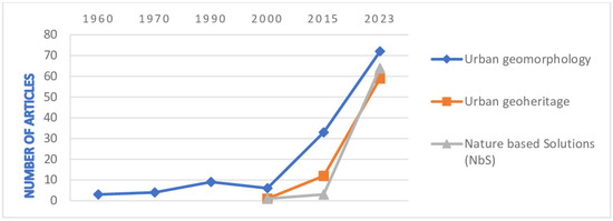
Figure 3.
Statistics of articles, analyzed by year, on urban geomorphology, urban geoheritage, and Nature-Based Solutions (NbSs).
During the literature review, priority was given to articles with scientific contributions in terms of methodology, and materials meeting the following criteria were excluded from the analysis:
- The methodology was not clearly related to our topic of interest or with limited information;
- Content was limited to a literature review;
- Articles predominantly focused on social and economic content.
After implementing the initial approach, which included different Excel sheets for the three subjects according to the specified criteria (Table 1), it was possible to trace the chronological development history of the methodologies and techniques employed in the literature. An extensive analysis was performed in order to identify patterns and trends in the methodologies that were applied in the urban geomorphology, urban geoheritage, and NbS research papers. These findings helped us to understand the evolution of academic interest and scientific achievements in this period of time.
Following this historical analysis, a comparison was made between the historical and contemporary methods and techniques utilized in urban geomorphology.
3.2. Methodological Proposal and Implementation
In order to propose solutions for the implementation of geomorphological mapping approaches in risky areas identified during the research, we introduced urban geoheritage research into the presented methodology and, furthermore, ensured the integration of NbSs into this methodology. As a result, the methodology proposed includes both traditional and non-traditional methods used in urban geomorphology and geoheritage research, combining them with the NbS approach.
The proposed methodology was applied to the city of Milan, Italy, which has experienced increased vulnerability to floods in recent decades. It includes a 48.07 km² expanse in the northern and northeastern zones of the city, which are prone to flooding caused by the Seveso and Lambro rivers. The necessary data (e.g., DEM and climate data) for implementing the proposed methodology were collected from official resources such as the Geoportal of Lombardy [65], ISPRA [66], ISTAT [67], and Milan Geoportal [68]. Geographic Information System tools were utilized for the spatial analysis and general assessments conducted on the terrain. Assessments of slope, land use/land cover, lithology, geology, proximity, land surface temperature, and hypsometry were reclassified based on the weights provided in Table 2, ensuring their thorough integration into the susceptibility analysis. Raster calculations were conducted, integrating weighted parameters as inputs, to map susceptibility areas, particularly focusing on quantifying flooding susceptibility across the study area using mathematical calculations [69]. The mathematical formula used for the raster calculation was
Table 2.
Weights labeled for analysis of susceptibility.
In this formula, each input parameter (P) is multiplied by its corresponding weight (), and the results are summed together to determine the susceptibility index (SI), which ranged from very low to very high susceptibility. In addition, a spatial join technique was used along with additional information (e.g., buildings) to identify high-risk areas. Subsequently, we created appropriate NbS data for the identified high-risk areas within the city. The NbS data were generated through geocoding techniques applied to information collected from various sources [70,71]. Finally, the final map visually illustrating the urban geomorphology, urban geoheritage, and proposed NbS was assembled. The legend for the final map was primarily based on ‘Quaderno 13’ [72], which provides Italian guidelines for geomorphological mapping (Fascicolo I—Quaderno 13), along with other additional sources.
4. Results
4.1. Analyzed Literature Statistics
Research documents utilizing different methodologies employed in the study of urban geomorphology, urban geoheritage, and Nature-Based Solutions between 1950 and 2023 were selected from the Web of Science (WoS), Google Scholar, Scopus (Elsevier), and ResearchGate online platforms, and analyzed based on the criteria presented in Table 1. The statistics of the analyzed articles are illustrated in Figure 3.
A total of 267 academic papers from different sources (Table 3) were categorized into urban geoheritage (68 articles), urban geomorphology (127 articles), and NbSs (72 articles); these articles were analyzed and organized into three separate Excel files.
Table 3.
Number of collected and analyzed materials from different sources.
Thus, by tracing the chronological development of the methodologies and techniques used in the collected literature, the evolution of academic interest and scientific achievements during this period was determined. Consequently, we indeed observed a direct connection between the development of the analyzed methodologies and the evolution of urban landscapes. In fact, the complex development of cities has also contributed to the advancement of these research methods and techniques (Table 4).
Table 4.
Evolution of methodologies and techniques for urban geomorphological analyses.
4.2. Methodological Evolution over Time
Since the aftermath of the Second World War, rapid urbanization has become a global phenomenon [64]. This accelerated urban growth has engendered significant transformations in the physical landscape across urban areas, thereby presenting complex geomorphological challenges. Starting in the 1950s, extensive research has been focused on comprehensively investigating the multifaceted impacts of urbanization on landforms, effectively addressing the diverse range of issues involved [2,62,73,74,75,76,77,78,79,80,81,82,83]. As a result, the dynamic nature of these challenges has emphasized the need for the development of novel methodologies and techniques to further examine the complex interplay between urbanization and landforms.
Since the 1950s, the utilization of geological, topographic, cartographic, and aerial mapping for the examination of urban geomorphology has remained unaltered [73,79,84,85,86,87,88,89,90,91,92,93]. Aerial photography, as a valuable tool for earth feature analysis, presents expanded possibilities for enriching our comprehension of both cultural and natural landscapes. This method proves especially valuable in geographical applications by enabling the identification of alterations in physical and human phenomena through the systematic comparison of temporal sequences [25,94,95,96].
Satellite imagery’s ability to capture large geographic areas in one image has been instrumental since the 1970s for monitoring and categorizing land use and land cover across expansive regions. This is essential for evaluating shifts in landscapes, urban growth, and environmental dynamics. This methodology of utilizing satellite imagery is crucial for comprehensive LULC assessments in areas where ground-based data collection may be challenging. The outputs can facilitate the evaluation of landscape shifts, urban growth, and environmental dynamics, providing essential insights into areas where ground-based data collection may be challenging [76,78,97]. The accessibility of Earth data through satellites initiated the need for advanced GIS programs to process the raw data into coherent classifications, such as distinguishing urban areas [98]. The process typically involved employing principal components analysis for data reduction, alongside digital and computer-assisted change-detection techniques to identify significant changes and direct the analyst’s focus to specific regions [99].
In the last few decades, urban expansion has caused substantial changes in the natural landscape, including the destruction of green spaces and the redevelopment of former industrial areas [100]. These substantial changes have amplified the need for sustainable urban planning in cities, requiring improved monitoring and evaluation methodologies [101,102]. This heightened emphasis on sustainability necessitates an enhanced monitoring and evaluation methodology. In this context, a new form of RS called LiDAR (Light Detection and Ranging) has emerged as a crucial tool in 3D terrain modeling due to its capacity to collect thousands of elevation values per second with unprecedented precision and detail [42,103,104,105,106,107,108]. The LiDAR analysis method has been applied since the early 1960s [109] with the use of LiDAR data for feature extraction and 3D modeling of urban areas gaining more attention in the 1990s [103,104]. In the field of urban studies, LiDAR data are important for the 3D modeling of urban areas. It allows for the creation of detailed and accurate representations of buildings, vegetation, and other structures. This 3D modeling is invaluable for urban planning, infrastructure development, and disaster management. The integration of LiDAR into terrain science is significantly enhanced by its compatibility with the continuously advancing and cost-effective GISs [110,111].
The swift urbanization progress has given rise to additional research challenges. The increased human activity has led to a higher urban infrastructure density, consequently exposing certain knowledge gaps in the field. As a response to this, in the 2000s, the incorporation of machine learning techniques enabled more precise map processing and in-depth investigation of urban territories [112,113,114]. Automating change detection in urban areas through machine learning techniques is essential for enhancing precision and streamlining the identification and description of temporal alterations [112]. The integration of machine learning into GISs enhances their capability to extract valuable geographic insights, particularly in urban and human-related contexts, by enabling automated learning and interpretation of complex spatial data [113].
In the 21st century, deep learning has gained prominence within the field of machine learning. Deep learning, as an advanced machine learning technique, has found successful applications in urban areas, particularly in the domains of image recognition and classification [115,116,117,118,119]. This method has also been employed to strengthen hazard assessments in urban areas, significantly contributing to improved hazard evaluation and risk prediction.
The growing interest in urban geomorphology has become a pivotal aspect for various reasons. It plays an important role in preserving geoheritage [6,8,120,121,122,123,124] and identifying natural landforms within cities [6,125,126], ultimately enhancing the potential for geotourism experiences in urban environments [11,21,127,128,129,130,131,132,133,134]. Urban geoheritage, encompassing historical significance, unique geological features, cultural value, and human interactions, constitutes a significant aspect of the urban environment [5,7,19]. Information systems, photogrammetry, and digital tools have been recognized as essential for effectively analyzing and preserving urban geoheritage. These tools provide a means of representation and management of the data acquired through the gathering of documentary materials or metric surveys, enabling a better understanding and enhancement of urban geoheritage in cities [135,136]. Additionally, photogrammetry offers an efficient way to create detailed 3D models of objects or landscapes, allowing for the accurate measurement, analysis, visualization, and documentation of physical features in urban areas. The integration of GIS and remote sensing techniques can contribute to the monitoring and protection of urban geoheritage sites in urban environments. These tools can be used to map land use changes, predict future urban expansion, and identify potential threats to urban geoheritage, supporting informed decision-making and the development of strategies for urban geoheritage management and urban planning [133,135,136].
Acknowledged for its cultural and tourism value, urban geoheritage encompasses a diverse array of elements beyond geological formations. The cultural dimension of urban geoheritage extends past geological structures and can encompass various aspects, including architectural heritage, community spaces, and cultural practices. A historical building constructed with locally sourced geological materials, such as stone or other natural resources, represents a significant aspect of urban geoheritage, showcasing the intricate relationship between geological formations and urban development [6,129]. Moreover, urban geoheritage sites, including architectural landmarks, historical buildings, public squares, or community centers, can serve as community hubs or gathering places, hosting cultural events and festivals. Furthermore, urban geoheritage possesses tourism value, revealing the city’s geological and cultural heritage [17,120]. This aspect attracts individuals interested in exploring the distinctive features of the urban landscape. For instance, historical buildings constructed with locally sourced geological materials can serve as tourist attractions, showcasing the city’s geological history and architectural heritage [128,129].
Urban geoheritage is a relatively new concept, and in recent decades, it has been subject to research by different scholars, each employing different approaches and methodologies [137,138,139]. These methodologies include visual and observational approaches for urban geoheritage analyses, multidisciplinary methods combining historical and climatological data for regional geodiversity assessments, and comprehensive fieldwork followed by literature reviews and geological analyses to identify geological features in urban environments. Each approach is customized to suit the specific research objectives and the characteristics of the geological heritage under investigation [6,9,10,125,140,141,142].
Urban geomorphology and urban geoheritage are deeply interconnected, as they both play important roles in developing a comprehensive understanding of the historical evolution and significance of urban landscapes. These disciplines share a common approach involving the analysis of data and historical records spanning various time periods. This multitemporal approach enables researchers to trace the transformations within urban environments, pinpoint valuable heritage sites, and comprehend the repercussions of urbanization on natural elements.
As presented by Pica et al. [10], the integration of urban geomorphology and geoheritage assessments offers a holistic viewpoint of urban landscapes, aiding in the identification and preservation of culturally significant landmarks while simultaneously unraveling the underlying geological processes that shaped these urban areas.
4.3. Comparison between Traditional and New Methodologies
The field of urban geomorphology has evolved significantly in response to the challenges posed by rapid urbanization and advancements in technology (Figure 4). This transformation encompasses a shift from traditional geological and mapping methods to the incorporation of modern tools such as LiDAR, GIS, and machine learning, resulting in a more comprehensive understanding of urban landscapes and their historical significance. Moreover, the interconnection between urban geomorphology and geoheritage, coupled with a heightened focus on addressing climate change and disaster mitigation, has propelled these disciplines into the forefront of 21st century urban studies. The changing methodologies employed in urban geomorphology assessments offer a clear reflection of the evolving landscape of research. Historically, methodologies were rooted in exhaustive literature reviews and data collection, with a strong emphasis on field surveys and the analysis of various maps and models for the classification of urban landforms. After the 19th century, noticeable advancements in research methodologies in urban geomorphology became apparent.
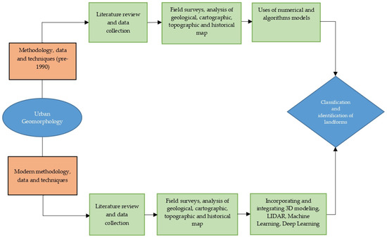
Figure 4.
Comparison of modern and pre-1990s approaches for urban geomorphological methodologies.
In the contemporary era, there is a marked continuity with the past. While traditional practices such as literature reviews and data collection persist, and field surveys and map analyses remain integral, the modern approach extends further to incorporate innovative elements and advanced techniques like LiDAR technology, machine learning (ML), and deep learning (DL). This blend of traditional and cutting-edge methodologies exemplifies the dynamic nature of urban geomorphology assessments.
Academic studies of urban geomorphology and geoheritage have incorporated considerations of climate change into their research [94,133,143]. However, it is essential to recognize that rapid urbanization is a significant factor that directly contributes to climate change [144]. Due to the unplanned use of the Earth’s surface and the extensive alteration of land cover, along with the complete destruction of vegetation, the natural system has been disrupted, which can result in natural disasters such as floods, landslides, etc., particularly in urban areas [145].
Hence, the investigation of urban geomorphology and geoheritage holds particular significance in mitigating these natural disasters and in the context of urban planning.
In the comprehensive examination of the literature, it was generally observed that research methods in urban areas tended to primarily focus on the analysis of issues concerning urban morphology, while simultaneously revealing a notable scarcity of proposals for addressing these problems. This gap highlights the need for a more comprehensive approach that integrates analyses with actionable solutions in urban planning.
4.4. NbS Methodology Review
In the 1970s, it was acknowledged that nature’s functions play an important role in benefiting human societies [146], and in the late 2000s, the term ‘Nature-Based Solutions’ emerged, with these approaches being implemented in various urban areas, resulting in positive outcomes [147,148]. NbSs have been extensively applied as a resilient approach in the collaborative effort to mitigate the impacts of climate change [44,54,149,150,151,152,153,154,155,156,157,158]. In the academic exploration of NbSs, the methodological framework involves integrating spatial analyses, cartographic techniques, and GIS tools. To define NbS methodologies, the application of a spatial understanding, overlaying theoretical constructs onto the geographical landscape, is essential [46,63,159,160]. The initial phase of the methodology involves a careful review and compilation of existing spatial data, including land use maps, climatic datasets, and relevant biodiversity indices. The incorporation of such spatial datasets serves as the foundation for understanding the baseline conditions and crucial contextual nuances in the context of NbSs [44,159,161].
The next stage involves crafting detailed maps that visually represent the theoretical foundations of NbSs. This may include mapping ecological hotspots, climate vulnerabilities, and areas designated for NbSs. The methodology for implementing NbSs has evolved significantly, with a focus on assessing vulnerability and susceptibility in specific regions to strategically apply NbS interventions. In recent studies, before the implementation of NbSs, the assessment of high-risk and vulnerable areas in the region is commonly performed through the evaluation and creation of susceptibility maps [47,162]. These maps identify the risk-prone areas, enabling the strategic application of NbSs in specific zones where interventions would be the most impactful.
The other important part of the NbS methodology is to apply green mapping. Green mapping helps in identifying and classifying urban green spaces, which is crucial for spatial planning. Mapping green spaces using techniques allows for a detailed analysis of the vegetation. Nature-Based Solutions can be implemented more effectively with a comprehensive understanding of the existing green spaces within an urban area [163,164,165].
Planning for NbSs begins with identifying the areas that are the most suitable for implementation. Additionally, the selection of NbS types is determined based on the susceptibility experienced in the area [47,150,166]. Selecting the appropriate NbS is crucial for addressing various urban challenges by integrating elements like permeable pavement systems, green roofs, city trees, etc., which contribute to sustainable urban development, climate resilience, and the enhancement of ecosystem services [167,168,169].
Subsequently, NbS mapping visually represents the spatial distribution of the selected NbS types, offering clear insights for urban planners, policymakers, and stakeholders.
4.5. Proposed Methodology with NbS Integration
Nature-Based Solution methodologies can be integrated following an in-depth urban geomorphological and geoheritage assessment. This integration is possible due to the shared emphasis on understanding and utilizing the geological and cultural characteristics of the urban landscape. For instance, after identifying and categorizing landforms and urban geoheritage elements, the subsequent application of NbS methodologies aligns with the geological and cultural context identified earlier.
This integration is beneficial for several reasons. Firstly, it allows for the strategic placement of NbS interventions based on a detailed understanding of the urban landscape’s geological features. For example, green infrastructure can be strategically implemented in areas with specific geological characteristics to enhance both ecological and cultural resilience. Secondly, by considering the cultural and tourism significance of urban geoheritage elements, NbSs can contribute to the preservation and promotion of these valuable assets.
The proposed methodology (Figure 5) incorporates NbSs in the study of urban geomorphology and geoheritage, aiming to address urban challenges and offer solutions to mitigate climate and human-related risks.
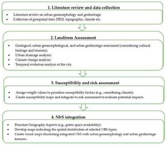
Figure 5.
The proposed methodology that integrates traditional and modern urban geomorphological and geoheritage assessment methods with NbSs.
An explanation of the actions involved in the proposed methodology and implementation of it are provided below.
4.5.1. Literature Review and Data Collection
In the initial phase, the methodology starts with a solid foundation of data. This involves gathering various datasets, such as topographic maps, satellite imagery, geological surveys, historical records, Digital Elevation Models (DEMs), land cover data, climate records, etc. Additionally, the exploration extends to land use changes, natural features, and alterations induced by human activities. The utilization of remote sensing techniques, such as LiDAR and aerial photography, can provide detailed information on the terrain morphology, vegetation distribution, and land use patterns over time [170,171]. The transition from desk-based research to on-site observations occurs through field surveys. These surveys provide essential ground truth data on landforms, soil characteristics, and the state of the urban infrastructure.
4.5.2. Landform Assessment
The methodology involves landform assessments, which include the systematic recognition and classification of both natural and anthropogenically modified landforms, as well as urban geoheritage elements within the urban area. This systematic process necessitates a comprehensive analysis of the geology, land use and land cover patterns, urban geomorphology, and urban geoheritage. Additionally, it involves analyzing urban drainage systems, assessing the impact of climate change, and analyzing the temporal evolution of the city.
Historical landform identification through remote sensing techniques is commonly practiced through LiDAR and GIS-based modelling. LiDAR scans offer a high spatial resolution and effective vegetation cover removal, making them valuable for detecting surface and subsurface features [171]. Additionally, DTMs derived from LiDAR data provide insights into pre-modern reliefs and the alignment of ancient features. Comparing historical cartography with modern topography from remote sensing data offers an effective approach to landform identification. This method utilizes map overlays, digitalization of elevation data, and contour lines to track significant morphological changes over time. It is particularly valuable for understanding anthropic landforms in historical urban contexts, allowing for the accurate analysis of volumetric changes and the identification of pre-existing elements in urban landscapes [170].
Acknowledging the dynamic character of geoheritage sites within urban settings is important, and requires a comprehensive evaluation of their geological, cultural, and tourism significance.
In terms of cultural assessments, the evaluation explores the roles of these landforms in the historical and cultural context of the urban setting. This cultural perspective enriches the understanding of these sites, acknowledging their influence in shaping the identity and heritage of the urban community.
Moreover, the evaluation extends to the tourism importance of these geoheritage sites. Landforms with distinctive geological characteristics or cultural significance can evolve into attractions, contributing to tourism development.
4.5.3. Susceptibility and Risk Assessment
The methodology introduces a crucial step of assigning weight values (Table 2) to susceptibility factors. This involves a consideration of the factors identified in the previous stages, prioritizing them based on their perceived significance in contributing to susceptibility. Weight values are assigned to each factor to reflect their relative importance in influencing the vulnerability of the identified landforms. GIS tools play an important role in generating these spatial maps, depicting the distribution and intensity of the susceptibility factors. Visualizing and documenting the results form the final phase of this mapping process.
It is important to conduct risk mapping and integrate it with susceptibility mapping to better understand the potential impact of hazards on both physical and human elements. Data such as land use, population density, infrastructure, and other relevant variables can be included in the analysis to comprehensively assess the impact of hazards when integrating susceptibility data into a risk assessment process.
The inclusion of the susceptibility map in the final map helps to create an understanding of the vulnerable areas within the region.
4.5.4. NbS Integration
The methodology begins by integrating geographical aspects to identify areas suitable for specific purposes. This involves considering factors such as green space availability, etc., with an integration of spatial data on topography, water bodies, and natural features to assess the physical landscape. Simultaneously, demographic data, including population density, are factored in to understand the distribution and concentration of residents in the area. This comprehensive approach aims to provide a well-informed assessment of areas suitable for specific purposes, considering geographical aspects.
This process involves considering various factors to determine the most suitable types of NbSs for the urban area, followed by prioritizing the suitable NbS types. The NbS mapping phase serves as the final thread, weaving Nature-Based Solutions into the urban environment. The integration of urban geomorphology, geoheritage, and NbSs on a map can be realized through a strategic process utilizing GIS technology and spatial analyses. This involves overlaying layers that depict various elements, including geomorphological features, geoheritage sites, and potential locations for NbSs. Visual maps serve as essential reference tools, depicting the suitable NbS types across the urban area. These visual representations not only showcase the spatial distribution of NbSs but also illustrate their integration with urban geomorphology and geoheritage features.
4.6. Implementation
The city of Milan, Italy, characterized by its dynamic urban landscape and various urban challenges, was chosen for the implementation of the proposed methodology. The initial stage of the methodology involved reviewing the literature, field surveys, and data collection. Based on the literature review, problematic areas of the city were identified in the north and northeast parts of the city. A field survey was performed to evaluate areas with a flooding risk. Furthermore, essential data (e.g., DEM and climate data) for conducting the analysis in the subsequent stages of the methodology were collected [65,66,67,68,70,72,172]. During the second stage of the methodology, geological, geomorphological, drainage system, geoheritage, spatio-temporal evolution, and climate change assessments were conducted to identify landscape forms and provide an overall evaluation on a territorial basis. Utilizing GIS tools, the analysis of landforms based on the DEM was conducted to evaluate the terrain parameters and extract the primary geomorphological elements. The data downloaded from the Geoportal of Lombardy [65] enabled an assessment of the geological characteristics within the urban area. Moreover, for the analysis of urban geoheritage, data were extracted from the same source, which highlights a selection of significant properties dating back to the late 19th century. The dataset offers a comprehensive overview of these properties, emphasizing significant aspects such as historical significance, distinctive construction methods and materials, and common architectural styles characteristic of the period. Among the reported materials were terracotta, solid bricks, exposed brick decorations, wood, and marble, reflecting the diverse building techniques prevalent during their construction periods. After observing all the features of these structures, selected data were extracted and classified under the cultural category due to their historical and architectural significance, while others were categorized under tourism due to their appeal to visitors. Furthermore, land use and land cover analyses were performed and mapped to understand the spatial distribution of different land types and their changes over time. This analysis included examining patterns of urbanization, agricultural activity, and natural vegetation cover within the study area.
For the spatio-temporal evolution analysis of Milan’s administrative area, historical map layers were retrieved using the WMS service provided by the geoportal of Lombardy [172]. These maps, dating from 1956, 1984, and 2021, were subsequently georeferenced and digitized. This result was intended to be integrated into the final map’s primary mapping phase.
Additionally, a drainage analysis was conducted using the digital terrain model, involving a comprehensive examination of applied hydrology techniques to extract water flow patterns based on reservoirs and water sources.
Concurrently, based on data taken from ISPRA resource [66], a climate change assessment revealed weather changes from 1980 to 2022, as depicted in Figure 6 and Figure 7. Both precipitation (Figure 6) and mean temperature (Figure 7) are vital metrics for comprehending and evaluating the impacts of climate change on local and regional environments. Incorporating land surface temperature data is important in assessing flood risks as it influences factors such as evaporation rates, soil moisture, and vegetation health, which in turn affect rainfall dynamics. This indicator is also utilized in risk assessment processes.
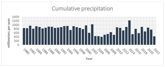
Figure 6.
Cumulative yearly precipitation for Milan, 1980–2022.
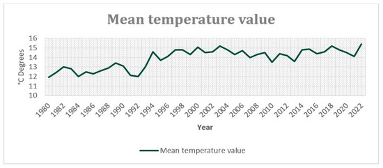
Figure 7.
Mean temperature values for Milan from 1980 to 2022.
In the third stage, focusing on susceptibility and risk assessments, the analysis conducted on the terrain was integrated to carry out an analysis of high-risk areas, resulting in the generation of a flood susceptibility map. Initially, the relevant data were collected and organized, followed by narrowing down the focus area for analysis, through the utilization of GIS tools. Next, the vector data were converted into raster data for reclassification based on vulnerability. This involved assigning weights to different thematic classes on a scale of 1 to 5 (very low–very high), representing varying levels of vulnerability to floods (Table 2 and Table 5). Each factor was analyzed to determine its potential impact on vulnerability to hazards, thus informing the overall susceptibility classification. For example, in the land cover/land use dataset, built-up areas were considered to have very high susceptibility due to their increased vulnerability to flood hazards. In the geology dataset, terraced deposits were rated with high susceptibility due to potential instability, whereas fluvioglacial and Würm fluvial deposits were categorized as medium susceptibility, reflecting their relatively improved drainage properties compared to terraced deposits. Similarly, no soil areas were considered very highly susceptible due to instability, while well-graded gravels with various components were classified as highly susceptible, and poorly graded gravels were rated as having a medium susceptibility due to their drainage properties. The proximity to rivers was also considered, with areas closer to rivers rated as having higher susceptibility due to an increased flood risk. Additionally, factors such as lithology, land surface temperature (LST), hypsometry, and slope were also evaluated. Higher land surface temperature (LST) values indicate warmer surface temperatures, which result in increased evaporation rates and reduced soil moisture content, consequently lowering the susceptibility to flooding, while lower LST values suggest cooler surface temperatures, potentially indicating higher soil moisture levels and an increased susceptibility to flooding. Additionally, lower elevation areas were categorized as having higher susceptibility levels due to the increased risk of flooding, especially in proximity to rivers. Following the analysis of layers, raster calculations were performed to define the susceptibility areas.
Table 5.
Weights given to every dataset included in analysis.
Subsequently, the flood risk assessment involved integrating susceptibility data with demographic factors to spatially and statistically determine the impact on both physical elements and human lives. By using spatial joining, the susceptibility data were incorporated into the analysis along with demographic information [67], such as the number of affected buildings within the susceptibility classes, providing a comprehensive understanding of the risk posed by flooding on both the environment and human settlements. The susceptibility map was intended to be integrated into the final map’s primary mapping phase.
The fourth stage of the methodology included integrating geographical aspects, demographic data, and spatial analyses using GIS tools to assess areas suitable for specific purposes, prioritize Nature-Based Solution types, and map the integration of NbSs with urban geomorphology and geoheritage features. During this stage, population density and green mapping were conducted to propose Nature-Based Solutions for the identified vulnerable areas.
The technique used to construct the NbS database for the analysis area involved extracting data from auxiliary sources [70,71] that do not provide geographic data, only information. This information was then geocoded using geocoding techniques. Considering the vulnerability of the area to floods, proposals for permeable pavement and green roofs were developed and prepared.
The concluding stage involved portraying the urban geomorphology, urban geoheritage, and proposed NbSs on the final map. In the final map (Figure 8a), the legend for the urban geomorphology was prepared following the symbols outlined in the ‘Quaderno 13′ Italian geomorphological mapping guideline [72]. The preparation of the geoheritage [9,140] and NbS legend symbols was based on a review of various literature sources [43,45]. The enrichment of symbols utilized in the legend can be expanded based on the conducted research area and proposed NbS solutions. Figure 8b–d illustrates the field survey conducted to assess areas vulnerable to flooding. As noted earlier, the spatio-temporal evolution map and susceptibility map were included in the final map’s primary mapping phase. Tracing the historical evolution of the city is essential for understanding the development of urban geomorphology, and it is important to incorporate a map depicting the historical development of the city into the cartographic representations in the final map (Figure 8a). Moreover, the addition of a susceptibility map visualizing the city’s high-risk areas serves as a supportive element in the overall evaluation of the final map.
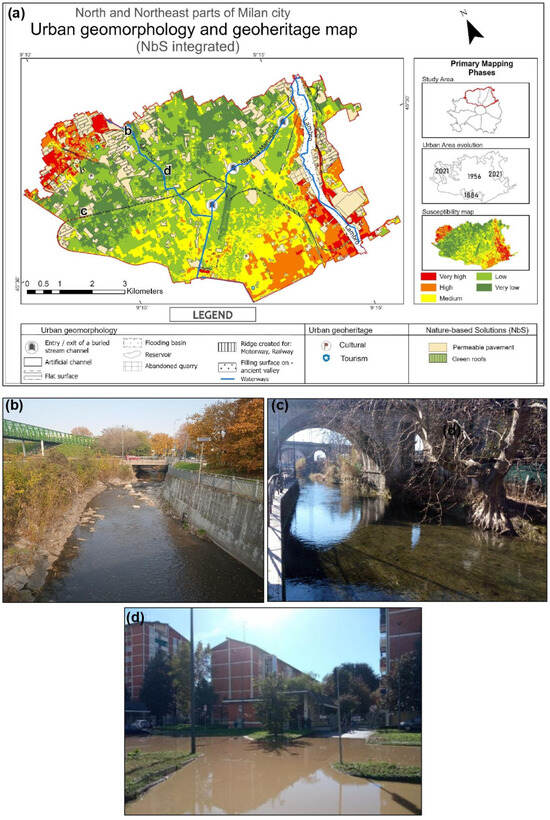
Figure 8.
(a) Main map: map of NbSs integrated with urban geomorphology and geoheritage for north and northeast parts of Milan, Italy, incorporating hydrographic features including the Seveso and Lambro rivers and Naviglio Martesana canal. Observed artificial landforms in the area: (b) Seveso River bed, a fully artificial channel; (c) Naviglio Martesana canal; (d) flooded resident area due to the Seveso flooding on 31 October 2023 (photo acquired from a resident citizen).
The outcome is a distinct visual representation that highlights the relationships between these components in the urban landscape. This method, incorporating visual elements, serves as a practical and easily comprehensible tool for advancing sustainable urban development.
5. Discussion
The analysis of the literature indicated that the study of urban geomorphology has been historically significant. Identifying and evaluating natural and anthropogenically modified urban landforms contributes to a detailed understanding of the urban landscape. In this context, maps traditionally play an essential role in examining the formation and historical changes of these landforms that were influenced by both human and natural factors. Furthermore, mapping has acquired contemporary significance in the field of urban geomorphology and geoheritage studies. This approach is essential in recognizing geological hazards, informing sustainable urban strategies, and facilitating decision-making amid urban expansion and environmental intricacies.
Through the examination of articles, it became evident that in urban geomorphological research, there is often a lack of geoheritage integration. The inclusion of urban geoheritage in the examination of urban geomorphology is important, given that geoheritage constitutes a fundamental component of the geomorphic characteristics of the urban environment. Concurrently investigating both aspects is imperative for a thorough examination of the urban geomorphological landscape, revealing the scientific, touristic, and cultural significance of numerous geoheritage features within urban areas. Providing cultural and tourism assessments enhances the comprehension of these landforms and acknowledges their multifaceted contributions to the essence of urban existence. However, the significance of these urban landscape forms may diminish, change, or lose value due to human activities, underscoring the importance of including geoheritage in urban geomorphological analyses.
Moreover, this study emphasized that the analysis of urban areas often overlooks many details, and the absence of consideration for geoheritage is not the only apparent gap in understanding urban geomorphology. Thus, another prevalent gap in urban geomorphology studies is the notable lack of proposed solutions to the identified urban issues.
As mentioned in the preceding paragraphs, the growing recognition of NbSs in promoting sustainable urban environments has gained attention in recent years [148,149,150]. Acknowledging the rising importance of NbSs, this study recommends integrating these approaches into urban geomorphology and geoheritage research. The suggestion is to conduct NbS research after a thorough general urban study to produce more effective and applicable results. The proposed methodology aligns with this approach, emphasizing the need to comprehensively understand the urban landscape before implementing solutions. The proposed methodology in this study offers a systematic approach for integrating Nature-Based Solutions into urban geomorphology and geoheritage conservation practices. It commences with a thorough literature review followed by landform assessments, leading to the creation of a susceptibility map to identify risk areas. The selection of susceptibility mapping for identifying risk areas was driven by its capability to provide a spatially explicit assessment of vulnerability, thereby enabling the precise targeting of Nature-Based Solutions. Subsequently, the methodology integrates NbSs into urban geomorphology and geoheritage assessments, resulting in an integrated map.
The practical implementation of this approach was effectively demonstrated through its application in an urban area. The study was conducted in Milan’s northern and northeastern urban areas, focusing on landscape analyses and identifying vulnerable zones for NbS implementation, particularly against flooding. Figure 8a visually represents the strategic integration of NbSs into urban geomorphology and urban geoheritage mapping, which was facilitated by GIS tools.
This proposed methodology primarily focuses on mapping various urban features, including geoheritage features, and identifying risk areas for implementing Nature-Based Solutions. Combining knowledge of valuable urban features with NbS applications can provide a more comprehensive tool for further urban planning and management. However, our methodology may require additional resources and expertise for implementation compared to traditional mapping methods, and the integration of NbSs introduces complexities that may limit its accessibility to researchers and practitioners with diverse backgrounds.
Having examined the initial version of the proposed methodology, it should be noted that the approach is open to various expansions and additions, facilitating its alignment with different urban environments. The aim was to assess the adaptability and efficacy of this methodology in diverse urban settings, and conduct in-depth explorations to offer detailed insights into its application.
6. Conclusions
After examining 267 papers on the subjects of urban geomorphology, urban geoheritage, and Nature-Based Solutions, the analysis revealed the following outcomes:
- The progress of urban environmental development has contributed to the evolution of research methodologies implemented in urban settings;
- The application of traditional methodologies (e.g., field surveys and mapping) remains essential during the examination of urban geomorphology;
- In addressing the resolution of urban issues, the implementation of Nature-Based Solutions (NbSs) has demonstrated positive outcomes in recent years.
The research highlighted the gaps that are often disregarded in the comprehensive examination of the urban environment: (i) excluding geoheritage from urban geomorphological studies and (ii) the absence of proposed solutions to the identified challenges during the exploration of the urban geomorphology.
Consequently, we proposed a methodology that, through the joint exploration of urban geomorphology and geoheritage research, and the integration of NbSs, facilitates a comprehensive understanding of modified urban relief forms influenced by both natural and anthropogenic factors and provides solutions to the challenges faced by the urban environment.
The proposed methodology was implemented in the north and northeast parts of Milan, Italy. Consequently, a practical use of the methodology was demonstrated, showcasing a final map that represents the urban geomorphology and urban geoheritage, along with the integration of NbSs. By suggesting Nature-Based Solutions in Milan, we highlight the benefits of offering practical solutions that consider urban geoheritage and urban geomorphology.
It should be noted that this methodology encompasses general application stages, but its implementation in various city environments may result in limitations. However, the proposed methodology was designed to be applicable to comprehensive research and diverse urban conditions in future investigations, making it open to various expansions and additions.
Author Contributions
Conceptualization, E.H., A.B. and M.D.A.; methodology, E.H., A.B. and M.D.A.; software, E.H. and L.F.; validation, E.H., A.B., L.F. and M.D.A.; formal analysis, E.H. and L.F.; investigation, E.H. and L.F.; writing—original draft preparation, E.H.; writing—review and editing, E.H., A.B., L.F. and M.D.A.; supervision, A.B. and M.D.A.; project administration, M.D.A.; funding acquisition, M.D.A. All authors have read and agreed to the published version of the manuscript.
Funding
This research was funded by PNRR “GeoSciences IR” M4—C 2—L.I. 3.1. Finanziato dall’Unione europea NextGenerationEU (CUP: I53C22000800006).
Data Availability Statement
The original contributions presented in the study are included in the article, further inquiries can be directed to the corresponding author.
Acknowledgments
We thank Pablo Flores for his help in English language editing.
Conflicts of Interest
The authors declare no conflicts of interest.
References
- Thornbush, M.J.; Allen, C.D. Urban Geomorphology: Landforms and Processes in Cities; Thornbush, M.J., Allen, C.D., Eds.; Elsevier: Amsterdam, The Netherlands, 2018; ISBN 978-0-12-811951-8. [Google Scholar]
- Coates, D.R. Urban Geomorphology; Geological Society of America: Boulder, CO, USA, 1976; ISBN 978-0-8137-2174-3. [Google Scholar]
- Barnsley, M.J.; Moller-Jensen, L.; Barr, S.L. Inferring urban land use by spatial and structural pattern recognition. In Remote Sensing and Urban Analysis; Routledge: London, UK, 2000; pp. 115–144. [Google Scholar]
- Li, S.; Yang, H.; Lacayo, M.; Liu, J.; Lei, G. Impacts of Land-Use and Land-Cover Changes on Water Yield: A Case Study in Jing-Jin-Ji, China. Sustainability 2018, 10, 960. [Google Scholar] [CrossRef]
- Emmanuel, R.; Giusti, C. The landscape and the cultural value of geoheritage. In Geoheritage; Elsevier: Amsterdam, The Netherlands, 2018; pp. 147–166. [Google Scholar]
- Pelfini, M.; Bollati, I.; Giudici, M.; Pedrazzini, T.; Sturani, M.; Zucali, M. Urban geoheritage as a resource for Earth Sciences education: Examples from Milan metropolitan area. ROL 2018, 45, 83–88. [Google Scholar] [CrossRef]
- Pijet-Migoń, E.; Migoń, P. Geoheritage and Cultural Heritage—A Review of Recurrent and Interlinked Themes. Geosciences 2022, 12, 98. [Google Scholar] [CrossRef]
- Pescatore, E.; Bentivenga, M.; Giano, S.I. Geoheritage and Geoconservation: Some Remarks and Considerations. Sustainability 2023, 15, 5823. [Google Scholar] [CrossRef]
- Coratza, P.; Bollati, I.M.; Panizza, V.; Brandolini, P.; Castaldini, D.; Cucchi, F.; Deiana, G.; Del Monte, M.; Faccini, F.; Finocchiaro, F.; et al. Advances in Geoheritage Mapping: Application to Iconic Geomorphological Examples from the Italian Landscape. Sustainability 2021, 13, 11538. [Google Scholar] [CrossRef]
- Pica, A.; Luberti, G.M.; Vergari, F.; Fredi, P.; Del Monte, M. Contribution for an Urban Geomorphoheritage Assessment Method: Proposal from Three Geomorphosites in Rome (Italy). Quaest. Geogr. 2017, 36, 21–36. [Google Scholar] [CrossRef]
- Kubalíková, L.; Kirchner, K.; Bajer, A. Secondary Geodiversity and its Potential for Urban Geotourism: A Case Study from Brno City, Czech Republic. Quaest. Geogr. 2017, 36, 63–73. [Google Scholar] [CrossRef]
- Krieger, P. Preserving geodiversity in Mexican hyper urban conflict zones: A geo-aesthetic approach. Int. J. Geoheritage Parks 2023, 11, 64–81. [Google Scholar] [CrossRef]
- Bollati, I.; Coratza, P.; Giardino, M.; Laureti, L.; Leonelli, G.; Panizza, M.; Panizza, V.; Pelfini, M.; Piacente, S.; Pica, A.; et al. Directions in Geoheritage Studies: Suggestions from the Italian Geomorphological Community. In Engineering Geology for Society and Territory; Lollino, G., Giordan, D., Marunteanu, C., Christaras, B., Yoshinori, I., Margottini, C., Eds.; Springer International Publishing: Cham, Switzerland, 2015; Volume 8, pp. 213–217. ISBN 978-3-319-09407-6. [Google Scholar]
- Melelli, L.; Silvani, F.; Ercoli, M.; Pauselli, C.; Tosi, G.; Radicioni, F. Urban Geology for the Enhancement of the Hypogean Geosites: The Perugia Underground (Central Italy). Geoheritage 2021, 13, 18. [Google Scholar] [CrossRef]
- Ferrando, A.; Bosino, A.; Bonino, E.; Coratza, P.; Faccini, F. Geomorphology and geoheritage in the Piana Crixia Natural Park (NW Italy). J. Maps 2023, 19, 2257731. [Google Scholar] [CrossRef]
- Habibi, T.; Ponedelnik, A.A.; Yashalova, N.N.; Ruban, D.A. Urban geoheritage complexity: Evidence of a unique natural resource from Shiraz city in Iran. Resour. Policy 2018, 59, 85–94. [Google Scholar] [CrossRef]
- Gordon, J.E. Rediscovering a Sense of Wonder: Geoheritage, Geotourism and Cultural Landscape Experiences. Geoheritage 2012, 4, 65–77. [Google Scholar] [CrossRef]
- Corovic, A.; Obralic, A. Contemporary Transformations of the Historic Urban Landscape of Sarajevo and Social Inclusion as a Traditional Value of a Multicultural Society. Land 2023, 12, 2068. [Google Scholar] [CrossRef]
- Szepesi, J.; Ésik, Z.; Soós, I.; Németh, B.; Sütő, L.; Novák, T.J.; Harangi, S.; Lukács, R. Identification of Geoheritage Elements in a Cultural Landscape: A Case Study from Tokaj Mts, Hungary. Geoheritage 2020, 12, 89. [Google Scholar] [CrossRef]
- Clarke, W.B. Plan of Milan. In Society for the Diffusion of Useful Knowledge; SDUK/Baldwin & Craddock: London, UK, 1832. [Google Scholar]
- Cappadonia, C.; Coratza, P.; Agnesi, V.; Soldati, M. Malta and Sicily Joined by Geoheritage Enhancement and Geotourism within the Framework of Land Management and Development. Geosciences 2018, 8, 253. [Google Scholar] [CrossRef]
- Lee, E.M. Geomorphological Mapping; Geological Society, London, Engineering Geology Special Publications: London, UK, 2001; pp. 53–56. [Google Scholar]
- Chelli, A.; Bordoni, M.; Cappadonia, C.; Pepe, G.; Rotigliano, E.; Smith, M. Geomorphological tools for mapping natural hazards. J. Maps 2021, 17, 1–4. [Google Scholar] [CrossRef]
- García-Soriano, D.; Quesada-Román, A.; Zamorano-Orozco, J.J. Geomorphological hazards susceptibility in high-density urban areas: A case study of Mexico City. J. S. Am. Earth Sci. 2020, 102, 102667. [Google Scholar] [CrossRef]
- Chirico, P.G.; Bergstresser, S.E.; DeWitt, J.D.; Alessi, M.A. Geomorphological mapping and anthropogenic landform change in an urbanizing watershed using structure-from-motion photogrammetry and geospatial modeling techniques. J. Maps 2021, 17, 241–252. [Google Scholar] [CrossRef]
- Drápela, E. Mapping of urban geoheritage in city of Liberec using participatory research. In (Teaching) Regional Geography, Proceedings of the 27th Central European Conference, Brno, Czech Republic, 17 October 2019; Masaryk University Press: Brno, Czech Republic, 2020; pp. 21–30. [Google Scholar]
- Quesada-Román, A.; Peralta-Reyes, M. Geomorphological Mapping Global Trends and Applications. Geographies 2023, 3, 610–621. [Google Scholar] [CrossRef]
- Vergari, F.; Marco Luberti, G.; Pica, A.; Del Monte, M. Geomorphology of the historic centre of the Urbs (Rome, Italy). J. Maps 2021, 17, 6–17. [Google Scholar] [CrossRef]
- Griffiths, J.S. Feet on the ground: Engineering geology past, present and future. QJEGH 2014, 47, 116–143. [Google Scholar] [CrossRef]
- Brandolini, P.; Del Monte, M.; Faccini, F.; Cattoor, B.; Zwoliński, Z.; Smith, M. Geomorphological mapping in urban areas. J. Maps 2021, 17, 1–5. [Google Scholar] [CrossRef]
- Pica, A.; AIGeo Working Group on Urban Geomorphology. The urban geomorphological survey and mapping as a support to risk assessment and communication tools, through the enhancement of the geological heritage. In Proceedings of the 10th International Conference on Geomorphology, Coimbra, Portugal, 12–16 September 2022. [Google Scholar]
- Gieryn, T.F. City as Truth-Spot: Laboratories and Field-Sites in Urban Studies. Soc. Stud. Sci. 2006, 36, 5–38. [Google Scholar] [CrossRef]
- Stäuble, S.; Martin, S.; Reynard, E. Historical mapping for landscape reconstruction: Examples from the Canton of Valais (Switzerland). In Mountain Mapping and Visualisation, Proceedings of the 6th ICA Mountain Cartography Workshop, Lenk, Switzerland, 11–15 February 2008; ETH Zurich, Institute of Cartography: Zurich, Switzerland; pp. 211–217.
- Baud, D.; Reynard, E. Géohistoire d’une trajectoire paysagère dans la plaine du Rhône valaisan. Analyse du secteur entre Riddes et Martigny (1840–1965). Norois 2015, 237, 15–31. [Google Scholar] [CrossRef]
- Clivaz, M.; Reynard, E. How to Integrate Invisible Geomorphosites in an Inventory: A Case Study in the Rhone River Valley (Switzerland). Geoheritage 2018, 10, 527–541. [Google Scholar] [CrossRef]
- Bathrellos, G.D.; Gaki-Papanastassiou, K.; Skilodimou, H.D.; Papanastassiou, D.; Chousianitis, K.G. Potential suitability for urban planning and industry development using natural hazard maps and geological–geomorphological parameters. Environ. Earth Sci. 2012, 66, 537–548. [Google Scholar] [CrossRef]
- Kasprzak, M.; Traczyk, A. LiDAR and 2D Electrical Resistivity Tomography as a Supplement of Geomorphological Investigations in Urban Areas: A Case Study from the City of Wrocław (SW Poland). Pure Appl. Geophys. 2014, 171, 835–855. [Google Scholar] [CrossRef]
- Del Monte, M.; D’Orefice, M.; Luberti, G.M.; Marini, R.; Pica, A.; Vergari, F. Geomorphological classification of urban landscapes: The case study of Rome (Italy). J. Maps 2016, 12, 178–189. [Google Scholar] [CrossRef]
- Ferreira, C.S.S.; Walsh, R.P.D.; Ferreira, A.J.D. Degradation in urban areas. Curr. Opin. Environ. Sci. Health 2018, 5, 19–25. [Google Scholar] [CrossRef]
- Ganguly, M.; Aynyas, R.; Nandan, A.; Mondal, P. Hazardous area map: An approach of sustainable urban planning and industrial development—A review. Nat. Hazards 2018, 91, 1385–1405. [Google Scholar] [CrossRef]
- Cariolet, J.-M.; Vuillet, M.; Diab, Y. Mapping urban resilience to disasters—A review. Sustain. Cities Soc. 2019, 51, 101746. [Google Scholar] [CrossRef]
- Van Westen, C.J.; Castellanos, E.; Kuriakose, S.L. Spatial data for landslide susceptibility, hazard, and vulnerability assessment: An overview. Eng. Geol. 2008, 102, 112–131. [Google Scholar] [CrossRef]
- Longato, D. A method to prioritize and allocate nature-based solutions in urban areas based on ecosystem service demand. Landsc. Urban Plan. 2023, 235, 104743. [Google Scholar] [CrossRef]
- Nordin von Platen, H.N.; Gustafsson, M. Nature-Based Solutions for Flood Risk Reduction, Contamination Control and Climate Change Adaption; KTH Royal Institute of Technology: Stockholm, Sweden, 2018. [Google Scholar]
- Guerrero, P.; Haase, D.; Albert, C. Locating Spatial Opportunities for Nature-Based Solutions: A River Landscape Application. Water 2018, 10, 1869. [Google Scholar] [CrossRef]
- Asare, P.; Atun, F.; Pfeffer, K. Spatial Multi-Criteria Analysis for Discovering Nature-Based Solutions Location for Urban Flood Mitigation in Accra. Appl. Spat. Anal. 2023, 17, 207–239. [Google Scholar] [CrossRef]
- Devanand, V.; Mubeen, A.; Vojinovic, Z.; Sanchez Torres, A.; Paliaga, G.; Abdullah, A.; Leitão, J.; Manojlovic, N.; Fröhle, P. Innovative Methods for Mapping the Suitability of Nature-Based Solutions for Landslide Risk Reduction. Land 2023, 12, 1357. [Google Scholar] [CrossRef]
- Beceiro, P.; Brito, R.S.; Galvão, A. Assessment of the contribution of Nature-Based Solutions (NBS) to urban resilience: Application to the case study of Porto. Ecol. Eng. 2022, 175, 106489. [Google Scholar] [CrossRef]
- Conti, M.E.; Battaglia, M.; Calabrese, M.; Simone, C. Fostering Sustainable Cities through Resilience Thinking: The Role of Nature-Based Solutions (NBSs): Lessons Learned from Two Italian Case Studies. Sustainability 2021, 13, 12875. [Google Scholar] [CrossRef]
- Dushkova, D.; Haase, A.; Wolff, M.; Haase, D. Editorial for Special Issue “Nature-Based Solutions (NBS) in Cities and Their Interactions with Urban Land, Ecosystems, Built Environments and People: Debating Societal Implications”. Land 2021, 10, 937. [Google Scholar] [CrossRef]
- Goodwin, S.; Olazabal, M.; Castro, A.J.; Pascual, U. Global mapping of urban nature-based solutions for climate change adaptation. Nat. Sustain. 2023, 6, 458–469. [Google Scholar] [CrossRef]
- Egerer, M.; Haase, D.; McPhearson, T.; Frantzeskaki, N.; Andersson, E.; Nagendra, H.; Ossola, A. Urban change as an untapped opportunity for climate adaptation. Npj Urban Sustain. 2021, 1, 22. [Google Scholar] [CrossRef]
- Mahmoud, I.H.; Morello, E.; Salvia, G.; Puerari, E. Greening Cities, Shaping Cities: Pinpointing Nature-Based Solutions in Cities between Shared Governance and Citizen Participation. Sustainability 2022, 14, 7011. [Google Scholar] [CrossRef]
- Kabisch, N.; Frantzeskaki, N.; Pauleit, S.; Naumann, S.; Davis, M.; Artmann, M.; Haase, D.; Knapp, S.; Korn, H.; Stadler, J.; et al. Nature-based solutions to climate change mitigation and adaptation in urban areas: Perspectives on indicators, knowledge gaps, barriers, and opportunities for action. Ecol. Soc. 2016, 21, art39. [Google Scholar] [CrossRef]
- Dushkova, D.; Haase, D. Not Simply Green: Nature-Based Solutions as a Concept and Practical Approach for Sustainability Studies and Planning Agendas in Cities. Land 2020, 9, 19. [Google Scholar] [CrossRef]
- Lombardi, G.; Ceppi, A.; Ravazzani, G.; Davolio, S.; Mancini, M. From Deterministic to Probabilistic Forecasts: The ‘Shift-Target’ Approach in the Milan Urban Area (Northern Italy). Geosciences 2018, 8, 181. [Google Scholar] [CrossRef]
- Servizio Geologico d’Italia. Carta Geologica d’Italia Alla Scala 1:50000; Servizio Geologico d’Italia: Milan, Italy, 2016; p. 118.
- De Caro, M.; Crosta, G.B.; Frattini, P. Hydrogeochemical characterization and Natural Background Levels in urbanized areas: Milan Metropolitan area (Northern Italy). J. Hydrol. 2017, 547, 455–473. [Google Scholar] [CrossRef]
- Scotti, A. 6: The Sforza Castle of Milan (1450–1499). In A Renaissance Architecture of Power; Brill: Leiden, The Netherlands, 2015; pp. 134–162. [Google Scholar]
- Salata, S. Land use change analysis in the urban region of Milan. MEQ 2017, 28, 879–901. [Google Scholar] [CrossRef]
- Bettoni, M.; Maerker, M.; Bosino, A.; Schillaci, C.; Vogel, S. Bibliometric Analysis of Soil and Landscape Stability, Sensitivity and Resistivity. Land 2022, 11, 1328. [Google Scholar] [CrossRef]
- Cooke, R.U.; Brunsden, D.; Doornkamp, J.C.; Jones, D.K.C. Urban Geomorphology in Drylands; Cooke, R.U., Nationen, V., Eds.; Published on behalf of the United Nations University by Oxford University Press: Oxford, UK, 1982; Volume 4, ISBN 978-0-19-823239-1. [Google Scholar]
- Mubeen, A.; Ruangpan, L.; Vojinovic, Z.; Sanchez Torrez, A.; Plavšić, J. Planning and Suitability Assessment of Large-scale Nature-based Solutions for Flood-risk Reduction. Water Resour. Manag. 2021, 35, 3063–3081. [Google Scholar] [CrossRef]
- Diao, C. An approach to theory and methods of urban geomorphology. Chin. Geogr. Sci. 1995, 6, 88–95. [Google Scholar] [CrossRef]
- Geoportal of Lombardy. Available online: https://www.geoportale.regione.lombardia.it/ (accessed on 20 January 2024).
- ISPRA, The Italian Institute for Environmental Protection and Research. Available online: http://www.scia.isprambiente.it/wwwrootscia/Home_new.html# (accessed on 5 February 2024).
- Istat, Italian National Statistical Institute. Available online: https://www.istat.it/en/ (accessed on 20 January 2024).
- Milan Geoportal. Available online: https://geoportale.comune.milano.it/sit/dettagli/?uuid=C_F205%3ASIT_CENTRALE_M201280017%3A20160427 (accessed on 5 February 2024).
- Blais-Stevens, A.; Behnia, P. Debris flow susceptibility mapping using a qualitative heuristic method and Flow-R along the Yukon Alaska Highway Corridor, Canada. Nat. Hazards Earth Syst. Sci. 2016, 16, 449–462. [Google Scholar] [CrossRef]
- Clever Milano Project. Available online: https://milanoclever.net/ (accessed on 7 February 2024).
- Milan Metropolitan City. Available online: https://opencms10.cittametropolitana.mi.it/portale/ (accessed on 1 February 2024).
- Campobasso, C.; Carton, A.; Chelli, A.; D’Orefice, M.; Dramis, F.; Graciotti, R.; Guida, D.; Pambianchi, G.; Peduto, F.; Pellegrini, L. Aggiornamenti e integrazioni delle linee guida della Carta Geomorfologica d’Italia alla scala 1:50.000. Quad. Serv. Geol. Naz. 2021, 13, 1–37. [Google Scholar]
- Green, N.E. Aerial Photographic Interpretation and the Social Structure of the City; American Society of Photogrammetry: Bethesda, MD, USA, 1957. [Google Scholar]
- Walker, F. Geographical Applications of Photography. In Liverpool Essays in Geography; Steel, R.W., Lawton, R., Eds.; Longman: Harlow, UK, 1967; pp. 525–546. [Google Scholar]
- Wolman, M.G. A Cycle of Sedimentation and Erosion in Urban River Channels. Geogr. Ann. 1967, 49A, 385–395. [Google Scholar] [CrossRef]
- Hardy, E.E.; Belcher, D.J.; Phillips, E.S. Land Use Classification with Simulated Satellite Photography; Agricultural Information Bulletins 309024; United States Department of Agriculture, Economic Research Service: Washington, DC, USA, 1971; 352p.
- Hammer, T.R. Stream channel enlargement due to urbanization. Water Resour. Res. 1972, 8, 1530–1540. [Google Scholar] [CrossRef]
- Ellefsen, R.; Swain, P.H.; Wray, J.R. Urban Land-Use Mapping by Machine Processing of ERTS-1 Multispectral Data: A San Francisco Bay Area Example; Purdue University: West Lafayette, IN, USA, 1973. [Google Scholar]
- Graf, W.L. The impact of suburbanization on fluvial geomorphology. Water Resour. Res. 1975, 11, 690–692. [Google Scholar] [CrossRef]
- Boyer, M.C. Geomorphology and Floods. Proc. Indiana Acad. Sci. 1960, 70, 165–169. [Google Scholar] [CrossRef]
- Kondracki, J. Types of Natural Landscape (Geographical Environment) in Poland. Pol. Geogr. Rev. 1960, 29–39. [Google Scholar]
- Veatch, N.T. The Kansas Flood of 1951. J. AWWA 1952, 44, 765–774. [Google Scholar] [CrossRef]
- Leszczycki, S. National Plan of Geographical Research in Poland* 1956 to 1960. Pol. Geogr. Rev. 1956, 3–9. [Google Scholar]
- Lo, C.P. Modern Use of Aerial Photographs in Geographical Research. R. Geogr. Soc. 1971, 3, 164–169. [Google Scholar]
- Skilodimou, H.; Livaditis, G.; Bathrellos, G.; Verikiou-papaspiridakou, E. Investigating the flooding events of the urban regions of glyfada and voula, attica, greece: A contribution to urban geomorphology. Geogr. Ann. Ser. A Phys. Geogr. 2003, 85, 197–204. [Google Scholar] [CrossRef]
- Rivas, V.; Cendrero, A.; Hurtado, M.; Cabral, M.; Giménez, J.; Forte, L.; Del Río, L.; Cantú, M.; Becker, A. Geomorphic consequences of urban development and mining activities; an analysis of study areas in Spain and Argentina. Geomorphology 2006, 73, 185–206. [Google Scholar] [CrossRef]
- Kang, R.S.; Marston, R.A. Geomorphic effects of rural-to-urban land use conversion on three streams in the Central Redbed Plains of Oklahoma. Geomorphology 2006, 79, 488–506. [Google Scholar] [CrossRef]
- El Banna, M.M.; Frihy, O.E. Human-induced changes in the geomorphology of the northeastern coast of the Nile delta, Egypt. Geomorphology 2009, 107, 72–78. [Google Scholar] [CrossRef]
- Brown, A.G.; Tooth, S.; Bullard, J.E.; Thomas, D.S.G.; Chiverrell, R.C.; Plater, A.J.; Murton, J.; Thorndycraft, V.R.; Tarolli, P.; Rose, J.; et al. The geomorphology of the Anthropocene: Emergence, status and implications. Earth Surf. Process. Landf. 2017, 42, 71–90. [Google Scholar] [CrossRef]
- Brandolini, P.; Cappadonia, C.; Luberti, G.M.; Donadio, C.; Stamatopoulos, L.; Di Maggio, C.; Faccini, F.; Stanislao, C.; Vergari, F.; Paliaga, G.; et al. Geomorphology of the Anthropocene in Mediterranean urban areas. Prog. Phys. Geogr. Earth Environ. 2020, 44, 461–494. [Google Scholar] [CrossRef]
- Cappadonia, C.; Di Maggio, C.; Agate, M.; Agnesi, V. Geomorphology of the urban area of Palermo (Italy). J. Maps 2020, 16, 274–284. [Google Scholar] [CrossRef]
- Mandarino, A.; Luino, F.; Turconi, L.; Faccini, F. Urban geomorphology of a historical city straddling the Tanaro River (Alessandria, NW Italy). J. Maps 2021, 17, 29–41. [Google Scholar] [CrossRef]
- Hassan, A.; Almatar, M.G.; Torab, M.; Allen, C.D. Environmental Urban Plan for Failaka Island, Kuwait: A Study in Urban Geomorphology. Sustainability 2020, 12, 7125. [Google Scholar] [CrossRef]
- Brandolini, P.; Faccini, F.; Paliaga, G.; Piana, P. Urban Geomorphology in Coastal Environment: Man-Made Morphological Changes in a Seaside Tourist Resort (Rapallo, Eastern Liguria, Italy). Quaest. Geogr. 2017, 36, 97–110. [Google Scholar] [CrossRef]
- Del Monte, M. Aeternae Urbis Geomorphologia—Geomorphology of Rome. In Landscapes and Landforms of Italy; Soldati, M., Marchetti, M., Eds.; Springer: Berlin/Heidelberg, Germany; New York, NY, USA, 2017; ISBN 978-3-319-26192-8. [Google Scholar]
- Quesada-Román, A.; Castro-Chacón, J.P.; Boraschi, S.F. Geomorphology, land use, and environmental impacts in a densely populated urban catchment of Costa Rica. J. S. Am. Earth Sci. 2021, 112, 103560. [Google Scholar] [CrossRef]
- Anderson, J.R.; Hardy, E.E.; Roach, J.T.; Witmer, R.E. A Land Use and Land Cover Classification System for Use with Remote Sensor Data; Geological Survey Professional Paper; US Government Printing Office: Washington, DC, USA, 1976.
- Knoerl, J.J. Mapping History Using Geographic Information Systems. Public Hist. 1991, 13, 97–108. [Google Scholar] [CrossRef]
- Campbell, W.; Imhoff, M.; Robinson, J.; Gunther, F.; Boyd, R.; Anuta, M. Site-Characterization Information Using LANDSAT Satellite and Other Remote-Sensing Data: Integration of Remote-Sensing Data with Geographic Information Systems. A Case Study in Pennsylvania; NASA Goddard Space Flight Center (GSFC): Greenbelt, MD, USA; Computer Science Corp.: Silver Spring, MD, USA, 1983.
- Mou, J.; Chen, Z.; Huang, J. Predicting Urban Expansion to Assess the Change of Landscape Character Types and Its Driving Factors in the Mountain City. Land 2023, 12, 928. [Google Scholar] [CrossRef]
- Kondo, H.; Toda, S.; Okumura, K.; Takada, K.; Chiba, T. A fault scarp in an urban area identified by LiDAR survey: A Case study on the Itoigawa–Shizuoka Tectonic Line, central Japan. Geomorphology 2008, 101, 731–739. [Google Scholar] [CrossRef]
- Netzband, M.; Stefanov, W.; Redman, C.L. (Eds.) Applied Remote Sensing for Urban Planning, Governance and Sustainability; Springer: Berlin/Heidelberg, Germany; New York, NY, USA, 2007; ISBN 978-3-540-25546-8. [Google Scholar]
- Kletzli, R.; Peterson, J. Inertial measurement and LIDAR meet digital ortho photography: A sensor fusion boon for GIS. In Proceedings of the ESRI International Users Conference, San Diego, CA, USA, 27–31 July 1998. [Google Scholar]
- Gamba, P.; Houshmand, B. Integration of high resolution multispectral imagery with LIDAR and IFSAR data for urban analysis applications. Int. Arch. Photogramm. Remote Sens. 1999, 32.3W14, 111–117. [Google Scholar]
- Sofia, G.; Marinello, F.; Tarolli, P. Metrics for quantifying anthropogenic impacts on geomorphology: Road networks. Earth Surf. Process. Landf. 2016, 41, 240–255. [Google Scholar] [CrossRef]
- Aguilar, R.G.; Owens, R.; Giardino, J.R. The expanding role of anthropogeomorphology in critical zone studies in the Anthropocene. Geomorphology 2020, 366, 107165. [Google Scholar] [CrossRef]
- Guerra, V.; Guerra, C.; Nesci, O. Geomorphology of the town of Rimini and surrounding areas (Emilia-Romagna, Italy). J. Maps 2021, 17, 113–123. [Google Scholar] [CrossRef]
- Ascione, A.; Aucelli, P.P.C.; Cinque, A.; Di Paola, G.; Mattei, G.; Ruello, M.; Russo Ermolli, E.; Santangelo, N.; Valente, E. Geomorphology of Naples and the Campi Flegrei: Human and natural landscapes in a restless land. J. Maps 2021, 17, 18–28. [Google Scholar] [CrossRef]
- Collis, R.T.H. Lidar. Advances in Geophysics; Elsevier: Amsterdam, The Netherlands, 1969; Volume 1, pp. 113–139. [Google Scholar]
- Palmer, T.C.; Shan, J.J. Urban Modeling From Lidar Data in an Integrated Gis Environment. In Proceedings of the ASPRS Annual Conference, St. Louis, MO, USA, 23–27 April 2001. [Google Scholar]
- Allen, J.; Lu, K. Modeling and Prediction of Future Urban Growth in the Charleston Region of South Carolina: A GIS-based Integrated Approach. Conserv. Ecol. 2003, 8, art2. [Google Scholar] [CrossRef]
- Chan, J.C.-W. Detecting the Nature of Change in an Urban Environment: A Comparison of Machine Learning Algorithms. Photogramm. Eng. Remote Sens. 2001, 67, 213–226. [Google Scholar]
- Farrington, O.S.; Taylor, N.K. Machine Learning Applied to Geo-Archaeological Soil Data; School of Mathematical and Computer Sciences, Heriot-Watt University: Edinburgh, UK, 2003. [Google Scholar]
- Hecht, R.; Herold, H.; Meinel, G. Manfred Ferdinand Buchroithner Automatic Derivation of Urban Structure Types from Topographic Maps by Means of Image Analysis and Machine Learning. In Proceedings of the 26th International Cartographic Conference, Dresden, Germany, 25–30 August 2013. [Google Scholar]
- Lv, Q.; Dou, Y.; Niu, X.; Xu, J.; Xu, J.; Xia, F. Urban Land Use and Land Cover Classification Using Remotely Sensed SAR Data through Deep Belief Networks. J. Sens. 2015, 2015, 538063. [Google Scholar] [CrossRef]
- De, S.; Bhattacharya, A. Urban classification using PolSAR data and deep learning. In Proceedings of the 2015 IEEE International Geoscience and Remote Sensing Symposium (IGARSS), Milan, Italy, 26–31 July 2015; IEEE: Milan, Italy, 2015; pp. 353–356. [Google Scholar]
- Ma, L.; Liu, Y.; Zhang, X.; Ye, Y.; Yin, G.; Johnson, B.A. Deep learning in remote sensing applications: A meta-analysis and review. ISPRS J. Photogramm. Remote Sens. 2019, 152, 166–177. [Google Scholar] [CrossRef]
- Li, S.; Xiong, L.; Tang, G.; Strobl, J. Deep learning-based approach for landform classification from integrated data sources of digital elevation model and imagery. Geomorphology 2020, 354, 107045. [Google Scholar] [CrossRef]
- Lei, X.; Chen, W.; Panahi, M.; Falah, F.; Rahmati, O.; Uuemaa, E.; Kalantari, Z.; Ferreira, C.S.S.; Rezaie, F.; Tiefenbacher, J.P.; et al. Urban flood modeling using deep-learning approaches in Seoul, South Korea. J. Hydrol. 2021, 601, 126684. [Google Scholar] [CrossRef]
- Palacio-Prieto, J.L. Geoheritage Within Cities: Urban Geosites in Mexico City. Geoheritage 2015, 7, 365–373. [Google Scholar] [CrossRef]
- Li, Z.; Liu, H.; Luo, C.; Fu, G. Assessing Surface Water Flood Risks in Urban Areas Using Machine Learning. Water 2021, 13, 3520. [Google Scholar] [CrossRef]
- Vincent, A.M.; Parthasarathy, K.S.S.; Jidesh, P. Flood susceptibility mapping using AutoML and a deep learning framework with evolutionary algorithms for hyperparameter optimization. Appl. Soft Comput. 2023, 148, 110846. [Google Scholar] [CrossRef]
- Band, S.S.; Janizadeh, S.; Chandra Pal, S.; Saha, A.; Chakrabortty, R.; Melesse, A.M.; Mosavi, A. Flash Flood Susceptibility Modeling Using New Approaches of Hybrid and Ensemble Tree-Based Machine Learning Algorithms. Remote Sens. 2020, 12, 3568. [Google Scholar] [CrossRef]
- Soares, L.P.; Dias, H.C.; Garcia, G.P.B.; Grohmann, C.H. Landslide Segmentation with Deep Learning: Evaluating Model Generalization in Rainfall-Induced Landslides in Brazil. Remote Sens. 2022, 14, 2237. [Google Scholar] [CrossRef]
- Portal, C.; Kerguillec, R. The Shape of a City: Geomorphological Landscapes, Abiotic Urban Environment, and Geoheritage in the Western World: The Example of Parks and Gardens. Geoheritage 2018, 10, 67–78. [Google Scholar] [CrossRef]
- Faccini, F.; Giardino, M.; Paliaga, G.; Perotti, L.; Brandolini, P. Urban geomorphology of Genoa old city (Italy). J. Maps 2021, 17, 51–64. [Google Scholar] [CrossRef]
- Rodrigues, M.L.; Machado, C.R.; Freire, E. Geotourism routes in urban areas: A preliminary approach to the Lisbon geoheritage survey. Geoj. Tour. Geosites 2011, 8, 281–294. [Google Scholar]
- Del Lama, E.A.; de La Corte Bacci, D.; Martins, L.; da Gloria Motta Garcia, M. Urban geotourism and the Old Centre of São Paulo City, Brazil. Geoheritage 2015, 7, 147–164. [Google Scholar] [CrossRef]
- Borghi, A.; d’Atri, A.; Martire, L.; Castelli, D.; Costa, E.; Dino, G.; Favero Longo, S.E.; Ferrando, S.; Gallo, L.M.; Giardino, M.; et al. Fragments of the Western Alpine Chain as Historic Ornamental Stones in Turin (Italy): Enhancement of Urban Geological Heritage through Geotourism. Geoheritage 2014, 6, 41–55. [Google Scholar] [CrossRef]
- Moradipour, F.; Moghimi, E.; Beglou, M.J.; Yamani, M. Assessment of Urban Geomorphological Heritage for Urban Geotourism Development in Khorramabad City, Iran. Geoheritage 2020, 12, 40. [Google Scholar] [CrossRef]
- Górska-Zabielska, M.; Zabielski, R. Potential Values of Urban Geotourism Development in a Small Polish Town (Pruszków, Central Mazovia, Poland). Quaest. Geogr. 2017, 36, 75–86. [Google Scholar] [CrossRef]
- Chylińska, D.; Kołodziejczyk, K. Geotourism in an urban space? Open Geosci. 2018, 10, 297–310. [Google Scholar] [CrossRef]
- Vegas, J.; Díez-Herrero, A. An Assessment Method for Urban Geoheritage as a Model for Environmental Awareness and Geotourism (Segovia, Spain). Geoheritage 2021, 13, 27. [Google Scholar] [CrossRef]
- Dowling, R.K. Geotourism’s Global Growth. Geoheritage 2011, 3, 1–13. [Google Scholar] [CrossRef]
- Cigola, M. Digital tools for Urban and Architectural heritage. In Geospatial Research: Concepts, Methodologies, Tools, and Applications; IGI Global: Hershey, PA, USA, 2016. [Google Scholar]
- Agapiou, A.; Alexakis, D.D.; Lysandrou, V.; Sarris, A.; Cuca, B.; Themistocleous, K.; Hadjimitsis, D.G. Impact of urban sprawl to cultural heritage monuments: The case study of Paphos area in Cyprus. J. Cult. Herit. 2015, 16, 671–680. [Google Scholar] [CrossRef]
- Semeniuk, V.; Semeniuk, C.A. Human impacts on globally to regionally significant geoheritage features of the Swan Coastal Plain and adjoining coastal zone, southwestern Australia. In Gondwana to Greenhouse: Australian Environmental Geoscience ñ The Australian Environment; Gostin, V., Ed.; Australian Journal of Earth Sciences Special Publication: Warwick, Australia, 2001; Volume 21, pp. 181–199. [Google Scholar]
- Eder, W. Unesco Geoparks—A new initiative for protection and sustainable development of the Earth’s heritage. Neues Jahrb. Geol. Palaontol.-Abh. 1999, 214, 353–358. [Google Scholar] [CrossRef]
- Benvenuti, M.; Boni, M.; Brancucci, G.; Bortolami, M.; Costantini, E.; D’Andrea, M.; Gisotti, G.; Guado, G.; Marchetti, M.; Massoli Novelli, R.; et al. The conservation of geological heritage in Italy: State of the art and future perspectives of the “GEOSITES” project. In Proceedings of the Volume of the PROGEO’98 Meeting, Belogradchik, Bulgaria, 1–13 June 1998; pp. 117–123. [Google Scholar]
- Pica, A.; Vergari, F.; Fredi, P.; Del Monte, M. The Aeterna Urbs Geomorphological Heritage (Rome, Italy). Geoheritage 2016, 8, 31–42. [Google Scholar] [CrossRef]
- Vereb, V.; de Vries, B.V.W.; Guilbaud, M.-N.; Karátson, D. The Urban Geoheritage of Clermont-Ferrand: From Inventory to Management. Quaest. Geogr. 2020, 39, 5–31. [Google Scholar] [CrossRef]
- Faccini, F.; Ferrando, A.; Montanari, G.; Piana, P.; Saj, S.; Terrone, M.; Traverso, S. Artificial cavities and geo-risk assessment: The case of “The Strade Nuove and the system of the Palazzi dei Rolli” Unesco World Heritage site in Genoa (Italy). In Proceedings of the Hypogea2023, Genova, Italy, 29 September–1 October 2023. [Google Scholar]
- Zwoliński, Z.; Jasiewicz, J.; Mazurek, M.; Hildebrandt-Radke, I.; Makohonienko, M. Geohazards and Geomorphological Setting in Poznań Urban Area, Poland. J. Maps 2021, 17, 202–214. [Google Scholar] [CrossRef]
- Bazrkar, M.H.; Zamani, N.; Eslamian, S.; Eslamian, A.; Dehghan, Z. Urbanization and Climate Change. In Handbook of Climate Change Adaptation; Filho, W.L., Ed.; Springer: Berlin/Heidelberg, Germany, 2015. [Google Scholar] [CrossRef]
- Pielke, R.A., Sr. Land Use and Climate Change. Science 2005, 310, 1625–1626. [Google Scholar] [CrossRef]
- Westman, W.E. How Much Are Nature’s Services Worth?: Measuring the social benefits of ecosystem functioning is both controversial and illuminating. Science 1977, 197, 960–964. [Google Scholar] [CrossRef]
- Odum, H.T. Environment, Power, and Society for the Twenty-First Century: The Hierarchy of Energy; Columbia University Press: New York, NY, USA, 2007; ISBN 978-0-231-12886-5. [Google Scholar]
- Cohen-Shacham, E.; Walters, G.; Janzen, C.; Maginnis, S. (Eds.) Nature-Based Solutions to Address Global Societal Challenges; IUCN International Union for Conservation of Nature: Gland, Switzerland, 2016; ISBN 978-2-8317-1812-5. [Google Scholar]
- Gill, S.E.; Handley, J.F.; Ennos, A.R.; Pauleit, S. Adapting Cities for Climate Change: The Role of the Green Infrastructure. Built Environ. 2007, 33, 115–133. [Google Scholar] [CrossRef]
- Fink, H.S. Human-Nature for Climate Action: Nature-Based Solutions for Urban Sustainability. Sustainability 2016, 8, 254. [Google Scholar] [CrossRef]
- Griscom, B.W.; Adams, J.; Ellis, P.W.; Houghton, R.A.; Lomax, G.; Miteva, D.A.; Schlesinger, W.H.; Shoch, D.; Siikamäki, J.V.; Smith, P.; et al. Natural climate solutions. Proc. Natl. Acad. Sci. USA 2017, 114, 11645–11650. [Google Scholar] [CrossRef]
- Osaka, S.; Bellamy, R.; Castree, N. Framing “nature-based” solutions to climate change. WIREs Clim. Chang. 2021, 12, e729. [Google Scholar] [CrossRef]
- DeLosRíos-White, M.I.; Roebeling, P.; Valente, S.; Vaittinen, I. Mapping the Life Cycle Co-Creation Process of Nature-Based Solutions for Urban Climate Change Adaptation. Resources 2020, 9, 39. [Google Scholar] [CrossRef]
- Chausson, A.; Turner, B.; Seddon, D.; Chabaneix, N.; Girardin, C.A.J.; Kapos, V.; Key, I.; Roe, D.; Smith, A.; Woroniecki, S.; et al. Mapping the effectiveness of nature-based solutions for climate change adaptation. Glob. Chang. Biol. 2020, 26, 6134–6155. [Google Scholar] [CrossRef] [PubMed]
- Seddon, N.; Smith, A.; Smith, P.; Key, I.; Chausson, A.; Girardin, C.; House, J.; Srivastava, S.; Turner, B. Getting the message right on nature-based solutions to climate change. Glob. Chang. Biol. 2021, 27, 1518–1546. [Google Scholar] [CrossRef] [PubMed]
- Clemente, M.F.; D’Ambrosio, V.; Di Martino, F.; Miraglia, V. Quantify the Contribution of Nature-Based Solutions in Reducing the Impacts of Hydro-Meteorological Hazards in the Urban Environment: A Case Study in Naples, Italy. Land 2023, 12, 569. [Google Scholar] [CrossRef]
- Watkin, L.J.; Ruangpan, L.; Vojinovic, Z.; Weesakul, S.; Torres, A.S. A Framework for Assessing Benefits of Implemented Nature-Based Solutions. Sustainability 2019, 11, 6788. [Google Scholar] [CrossRef]
- Baldwin, M.; Fox, A.; Klondike, T.; Hovis, M.; Shear, T.; Joca, L.; Hester, M.; Cubbage, F. Geospatial Analysis and Land Suitability for “FloodWise” Practices: Nature-Based Solutions for Flood Mitigation in Eastern, Rural North Carolina. Land 2022, 11, 1504. [Google Scholar] [CrossRef]
- Jones, L.; Anderson, S.; Læssøe, J.; Banzhaf, E.; Jensen, A.; Bird, D.N.; Miller, J.; Hutchins, M.G.; Yang, J.; Garrett, J.; et al. A typology for urban Green Infrastructure to guide multifunctional planning of nature-based solutions. Nat.-Based Solut. 2022, 2, 100041. [Google Scholar] [CrossRef]
- Osseni, A.A.; Dossou-Yovo, H.O.; Gbesso, F.G.H.; Sinsin, B. GIS-Based Multi-Criteria Analysis for Selecting Suitable Areas for Urban Green Spaces in Abomey-Calavi District, Southern Benin. Land 2023, 12, 1553. [Google Scholar] [CrossRef]
- Fan, P.; Ouyang, Z.; Basnou, C.; Pino, J.; Park, H.; Chen, J. Nature-based solutions for urban landscapes under post-industrialization and globalization: Barcelona versus Shanghai. Environ. Res. 2017, 156, 272–283. [Google Scholar] [CrossRef]
- Luo, Z.; Tian, J.; Zeng, J.; Pilla, F. Resilient landscape pattern for reducing coastal flood susceptibility. Sci. Total Environ. 2023, 856, 159087. [Google Scholar] [CrossRef] [PubMed]
- Pristeri, G.; Peroni, F.; Pappalardo, S.E.; Codato, D.; Masi, A.; De Marchi, M. Whose Urban Green? Mapping and Classifying Public and Private Green Spaces in Padua for Spatial Planning Policies. IJGI 2021, 10, 538. [Google Scholar] [CrossRef]
- Biasin, A.; Masiero, M.; Amato, G.; Pettenella, D. Nature-Based Solutions Modeling and Cost-Benefit Analysis to Face Climate Change Risks in an Urban Area: The Case of Turin (Italy). Land 2023, 12, 280. [Google Scholar] [CrossRef]
- Croci, E.; Lucchitta, B. (Eds.) Nature-Based Solutions for More Sustainable Cities: A Framework Approach for Planning and Evaluation, 1st ed.; Emerald Publishing: Bingley, UK, 2022; ISBN 978-1-80043-637-4. [Google Scholar]
- Kalantari, Z.; Ferreira, C.S.S.; Keesstra, S.; Destouni, G. Nature-based solutions for flood-drought risk mitigation in vulnerable urbanizing parts of East-Africa. Curr. Opin. Environ. Sci. Health 2018, 5, 73–78. [Google Scholar] [CrossRef]
- Bhattacharjee, A. Forest Landscape Restoration as a NbS Strategy for Achieving Bonn Challenge Pledge: Lessons from India’s Restoration Efforts. In Nature-Based Solutions for Resilient Ecosystems and Societies; Dhyani, S., Gupta, A.K., Karki, M., Eds.; Disaster Resilience and Green Growth; Springer: Singapore, 2020; pp. 133–147. ISBN 9789811547119. [Google Scholar]
- Antunes, L.; Ghisi, E.; Thives, L. Permeable Pavements Life Cycle Assessment: A Literature Review. Water 2018, 10, 1575. [Google Scholar] [CrossRef]
- Mora-Melià, D.; López-Aburto, C.; Ballesteros-Pérez, P.; Muñoz-Velasco, P. Viability of Green Roofs as a Flood Mitigation Element in the Central Region of Chile. Sustainability 2018, 10, 1130. [Google Scholar] [CrossRef]
- Terrone, M.; Piana, P.; Paliaga, G.; D’Orazi, M.; Faccini, F. Coupling Historical Maps and LiDAR Data to Identify Man-Made Landforms in Urban Areas. IJGI 2021, 10, 349. [Google Scholar] [CrossRef]
- Schmidt, J.; Werther, L.; Zielhofer, C. Shaping pre-modern digital terrain models: The former topography at Charlemagne’s canal construction site. PLoS ONE 2018, 13, e0200167. [Google Scholar] [CrossRef]
- Milan Geoportal (WMS). Available online: https://geoportale.comune.milano.it/arcgis/services/Cartografie_Raster/Milano_2012_TIF_CTR_WebMercator_201610251643/ImageServer (accessed on 28 January 2024).
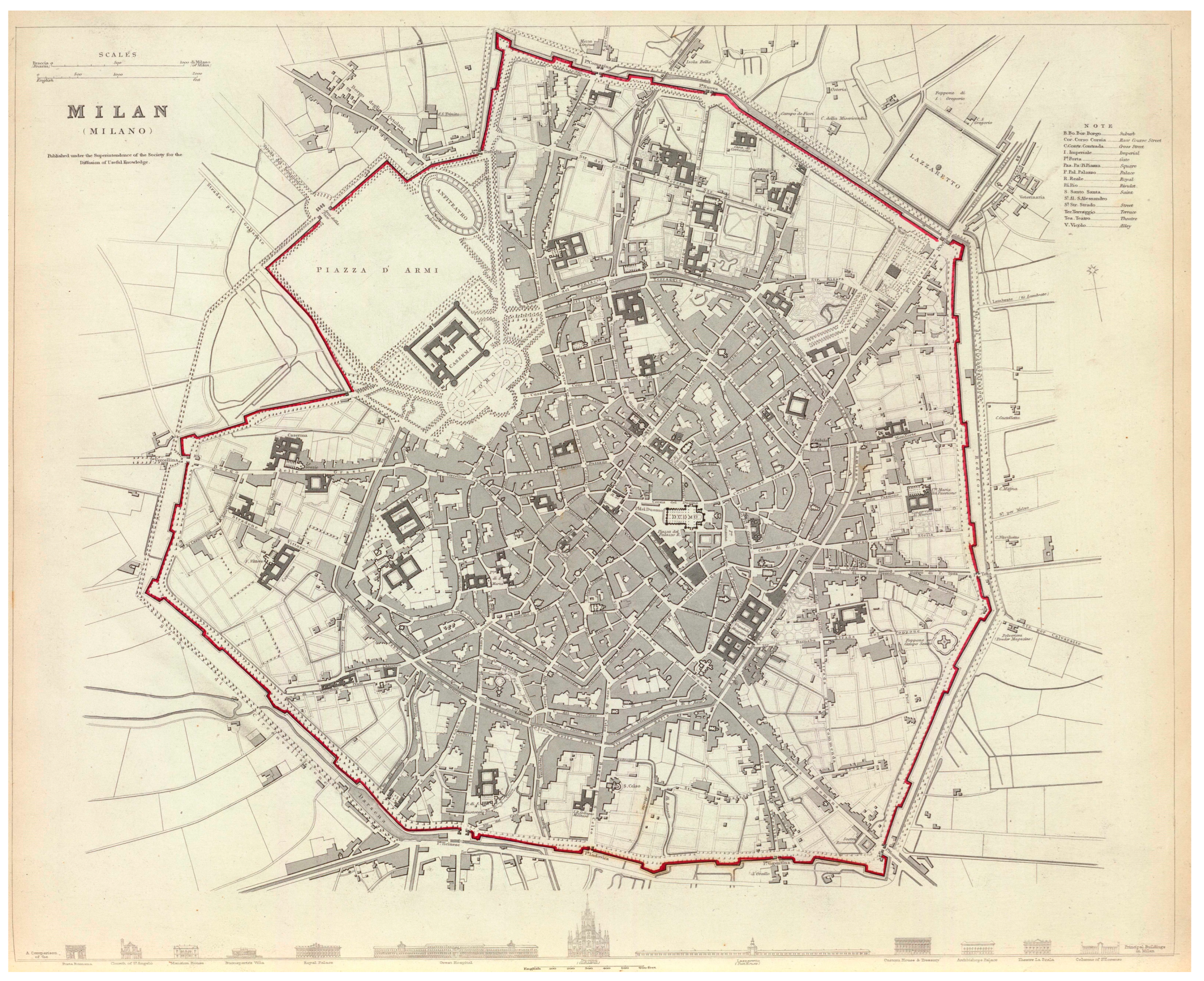

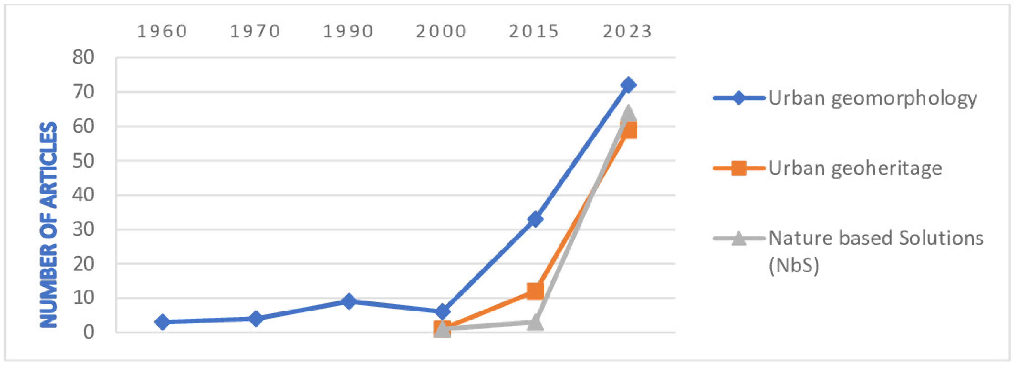

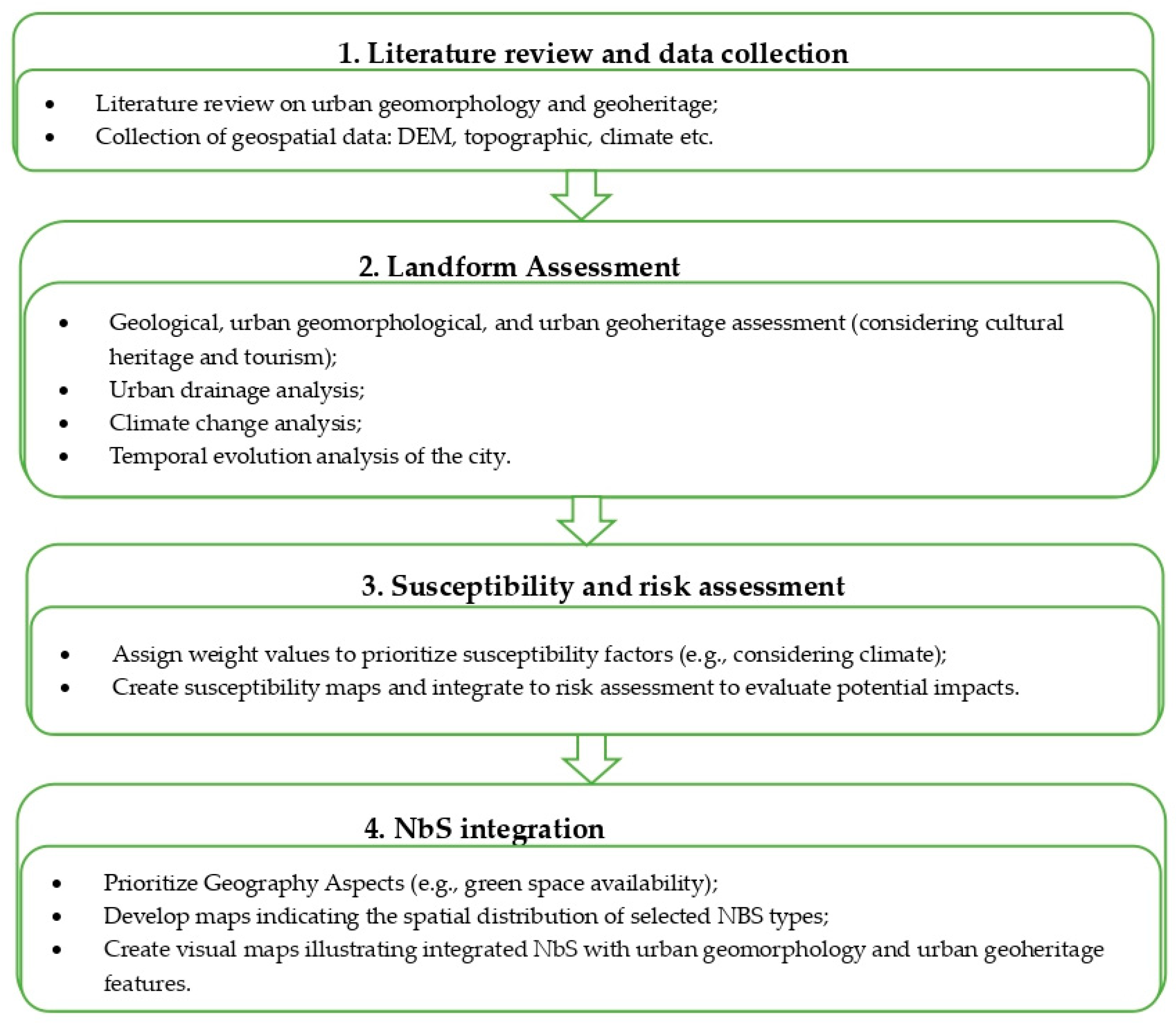

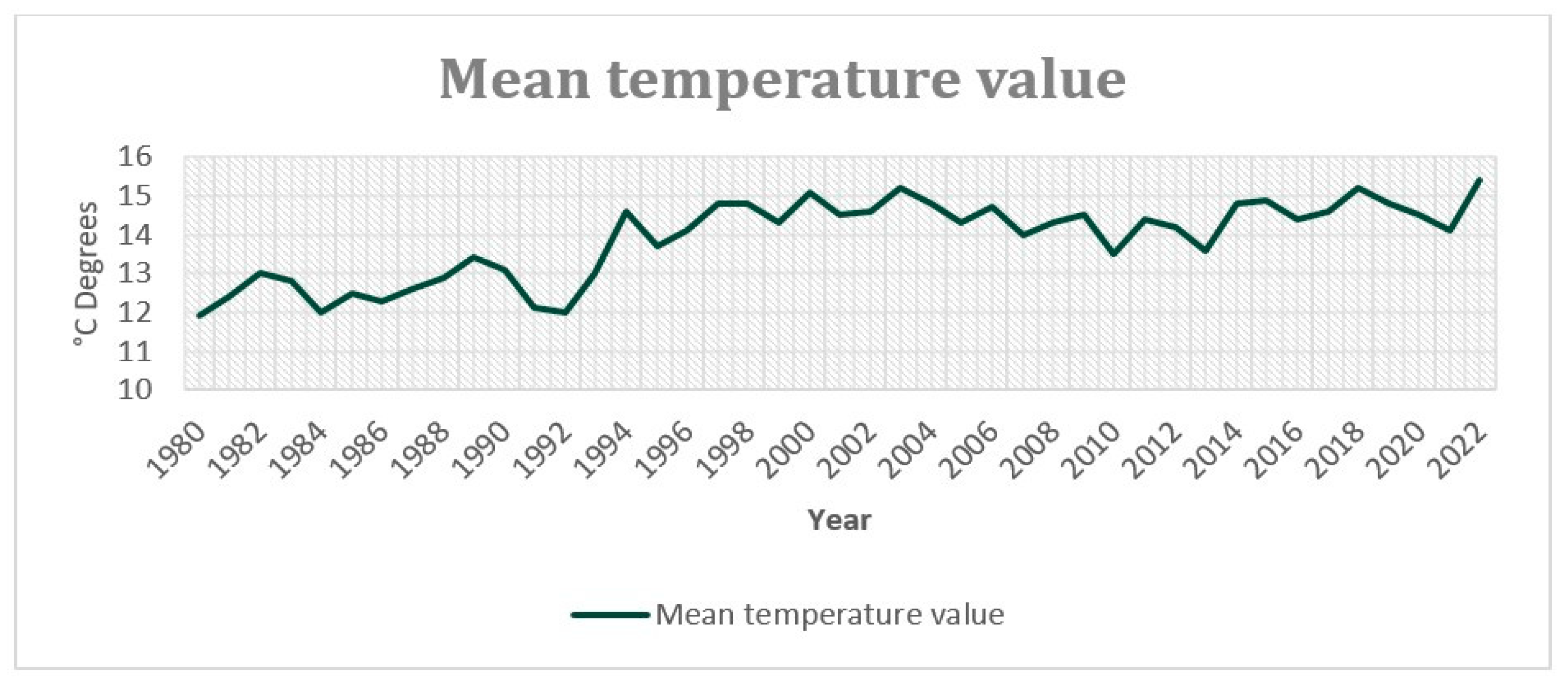
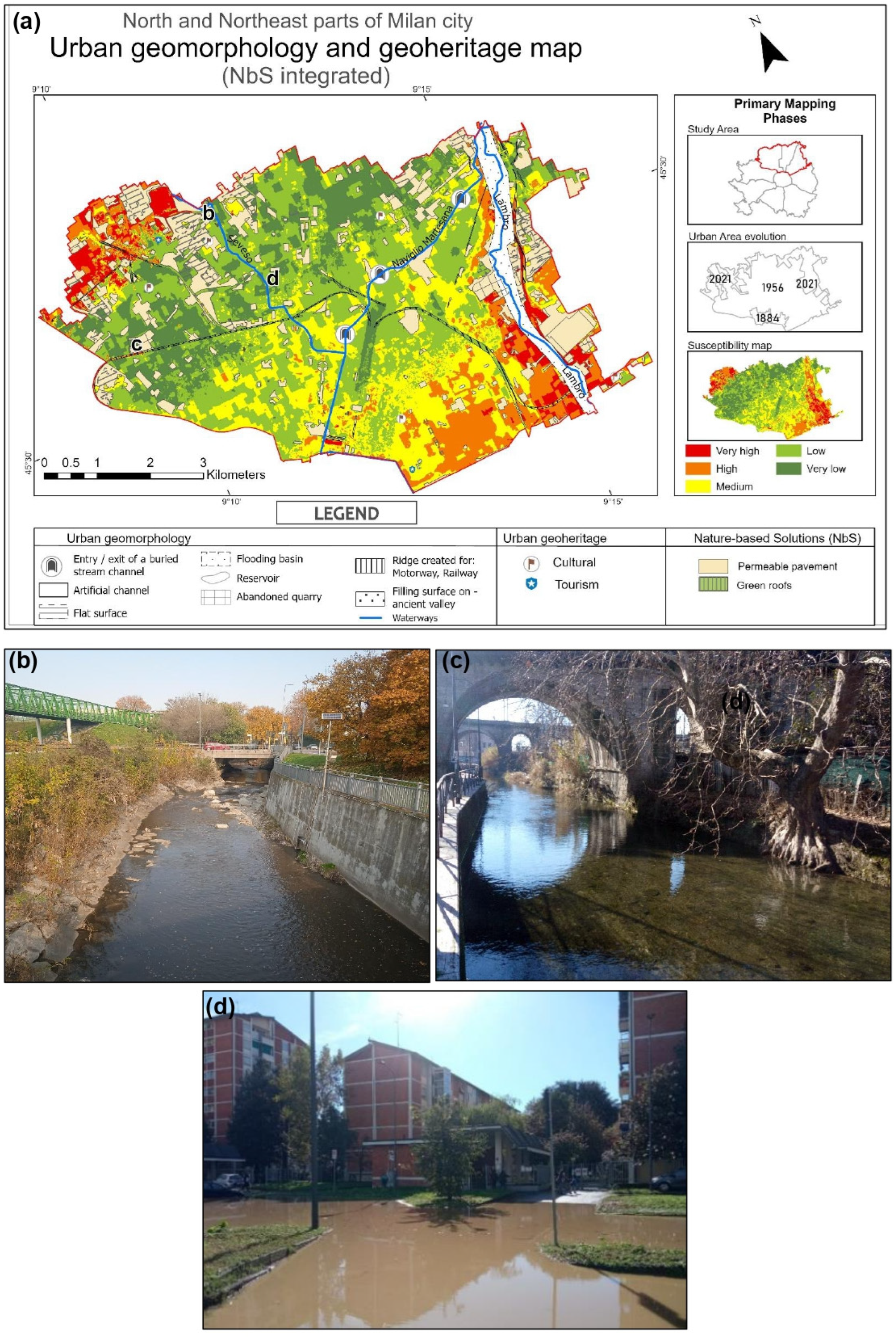
Disclaimer/Publisher’s Note: The statements, opinions and data contained in all publications are solely those of the individual author(s) and contributor(s) and not of MDPI and/or the editor(s). MDPI and/or the editor(s) disclaim responsibility for any injury to people or property resulting from any ideas, methods, instructions or products referred to in the content. |
© 2024 by the authors. Licensee MDPI, Basel, Switzerland. This article is an open access article distributed under the terms and conditions of the Creative Commons Attribution (CC BY) license (https://creativecommons.org/licenses/by/4.0/).