Abstract
The city represents a complex adaptive system consisting of a set of interconnected subsystems within self-organization and flexible structures that give it the ability to adapt to continue operating over time. This research discusses the adaptive flexibility of the complex urban system by measuring the degree of complexity and adaptation of secondary systems within the general system depending on its kinetic and visual system, making it self-organized and within a coherent and harmonious unit. Thus, the research problem arises from “the lack of knowledge on how to determine the appropriate degree of complexity and adaptation for urban systems, providing them with adaptive flexibility that allows them to maintain their energy and ensure their survival and continuity over time”. This research aims to determine the adaptive flexibility of the complex urban system, which keeps it self-organized and able to survive depending on its kinetic and visual system that links the secondary systems of the general system based on the degree of complexity and adaptation ideal. The research adopted quantitative analysis, which includes calculating the adaptive dimensions of the complex system based on the kinetic and visual system, as well as the nodes connecting the parts of the secondary system, in addition to determining both the area and the perimeter of the study area. The historic Karkh area in Baghdad was selected for implementation because it includes a model of the complex system that originated and developed within different time stages. The system’s adaptive flexibility was calculated to determine its ability to survive and continue. This research found that it is possible to determine the strength of the urban format and its ability to survive or not, as well as the possibility of developing it, by understanding the ideal degree of adaptive flexibility for the format. This ideal degree is 1, achieved through visual and kinetic coherence among the nodes that make up the parts of the format. The farther the format is from this degree, the less adaptive flexibility it has, which affects its ability to survive and continue. Therefore, it is necessary to maintain the strength of the interconnections between the parts of the kinetic and visual system and between the parts of the complex format, which directly affects its ability to self-regulate and survive.
1. Introduction
Marshall revealed that complex urbanization arises from the bottom up (from the emergence and development of secondary parts, represented by buildings, urban spatial tissues, and the kinetic system linking the parts). The process of understanding it depends on understanding the parts that formed this system, analyzing the emerging systems formed over time, and knowing the causes and motives of their emergence, which in turn directly affects the analysis of the complex system and determines the appropriate ways to address its parts. When studying and analyzing complex systems, their origins must be taken into account, which can be either as a result of the natural evolution of the urban system (spontaneously) or as a result of partial introduction and development processes or upper development processes that arise from top to bottom. In both cases, hierarchically differentiated system structures emerge, which may suggest central planning. However, it is not due to the presence of individual elements and parts within them that compete with each other. This includes what adapts, changes, decays, and ends. Therefore, it is important to study the relationship between the secondary parts formed within the general system and to understand the strength of the relationship between them [1].
The measurement of the strength of the sequence interconnection depends on the creation of elements and rules of the system interaction and the analysis of the emerging impact. Thus, a city consists of multiple sequences of hierarchical systems that evolve and change according to respective contextual rules and conditions.
Alexander described this concept as a semi-lattice concept and the evolution of consistency as a result of the cumulative collection and removal of parts and the representation of the changing needs of individuals [2]. It is necessary to determine the complex system’s ability to adapt and self-organize permanently and continuously because it grows and develops constantly as a result of changing its morphology, the essential elements that make it up, or the relations between its parts. This format change comes to meet cultural or economic needs or support different urban functions and may appear as a result of interventions for urban development projects of the city and the addition of parts or elements within the different systems that increase the degree of complexity of the system. Therefore, it was necessary to identify the relationship between secondary systems and their interconnections with each other, which directly affect the strength of the general urban system and facilitate the development processes of how to deal with the structural parts and strengthen the weak ones and strengthen them to ensure their continuity and preservation from extinction [3]. Since the secondary systems are interconnected with each other through kinetic and visual systems, this makes them of great importance in achieving general coordinate coherence; therefore, measuring the ability of complex systems to adapt requires knowledge of the strength of interdependence and finding elements and rules that allow the best interaction of the parts of the system. It also requires the analysis of the emerging influence and, thus, the understanding of the city, which consists of more than one complex system carrying sequential hierarchical systems that evolve and change according to the specific contextual rules and conditions, and this is what Christopher Alexander described within the concept of semilattice, where the systems develop as a result of the cumulative addition and deletion of the parts, the deletion or addition of appropriate kinetic associations between the parts, and the representation of the changing needs of individuals [4].
Thus, there is an intrasystem part correlation, which not only impacts the overall system but also acts as a basic or secondary factor. The factors share knots and joints, thus making the system coherent [5].
A complex system depends on the way that interpart relationships are interconnected and shaped. Within the system, the strength of the links between the nodes gives the entire system sufficient strength, flexibility, specificity, and spatial strength [6].
A complex system is influenced by the street structure, the road network, and knot-to-knot movement, while the strength of the system depends on the coherence of the kinetic axes, which increases the system’s strategic value [7].
Stereotypical behavior depends on unexpected interactions between autonomous parts. These parts additionally adapt to each other and, thus, regulate themselves, which enables the system to persist and evolve [6].
System flexibility is defined as adaptability without becoming a new coordinated identity and, thus, represents a dynamic ability to shift systems between adaptive situations without exceeding the threshold of irreversibility. Flexibility, in this sense, seeks to stabilize the system through diversity and part-wise interconnectedness [8].
The complex system is influenced by both the street structure and the traffic system (road network and traffic flow from one node to another). Such interdependence creates interconnected urban systems, which, in turn, contain intrasystem visual and kinetic relationships and associations [9]. Flexible consistency is adaptable only if it contains a diverse mix of internal and peripheral connections between the interconnection contract of its parts consisting of complex structures that are geometrically and topologically adapted and coherent because of their potential to maintain their entropy and bioenergy.
Within this consistency, flexibility heavily depends on its ability to relate and communicate with every possible number of contacts between components, and, therefore, the more points of contact there are, the more vivid and adapted this consistency [10]. Furthermore, each system needs appropriate, fragmented, and self-regulated complexities so that it can maintain its internal structure and balance. Moreover, these complexities can help the system work and adapt to external conditions [11].
The kinetic and visual system directly affects the coordinate adaptation, as it affects the relationship of secondary systems with each other, and flexible systems are adaptable only if they contain a diverse mix of internal and terminal connections between the connecting nodes of their parts. The flexibility of these systems depends largely on their ability to interconnect and connect with every possible number of connections between components; therefore, the more and larger the number of points of contact, the more and more these systems will be alive and adapted [12].
This system also possesses different degrees of complexity, indicators of change-oriented flexibility. Therefore, its balance and flexibility depend on the level of self-regulation generated by the part interconnectedness and the visual and kinetic hierarchies [13].
It is clear from the above that the complex adaptive system consists of a group of parts whose impact on the city varies due to the different types of kinetic and visual relations between the centers and nodes, which requires knowledge of the strength of the coordinate bonding that affects the adaptation and flexibility of these systems. Therefore, this research seeks to study the visual and kinetic system and its role in achieving adaptive flexibility and maintaining the ideal complexity of the urban system by knowing the appropriate degree of complexity and adaptation based on the kinetic and visual relationships and the nodes that make up the system and are responsible for linking its parts. The complex system is affected by the street structure, the road network, and the flow of traffic from one node to another, which gives the strength of the internal system that ensures the best self-organization and gives it the adaptive flexibility that makes it able to continue. The research aims to “determine the adaptive flexibility of the complex urban system, which keeps the system self-organized and viable depending on the kinetic and visual system that links the secondary systems of the general format based on the degree of complexity and optimal adaptation”. To achieve the objective of the research, the critical realism approach will be adopted, which relies on the use of reliable measurement to calculate the adaptive dimensions of the complex system based on the associative system of the coordinate parts (the relationship between the visual and kinetic axes between the nodes). We determine both the area and perimeter of the study area and then apply them to a selected sample that meets the requirements of the study and calculate the adaptive flexibility of the system by adopting the following steps:
- Build a theoretical framework and extract indicators to measure the adaptation of the complex system
- Determine the method of measuring indicators and apply them to an area characterized by a complex system to achieve the research objective.
2. Previous Studies
Different studies have been conducted on adaptable systems in urban planning, link-based measurements of complexity and adaptation, and kinetic and visual internode communications that form the intrasystem joining parts:
Boeing (2017) [14] showed that node-linking pathways in urban systems are indicators of the sequentially integrated parts, as the flexibility of adaptable consistency depends on the emerging and ongoing networking of the harmonious entirety to keep the system balanced.
System adaptability is measured using the shortest physical bonds with the least change in direction versus the optical linkages between the nodes as representations of adaptation and when the urban sequence is studied over different periods. Changeable interconnectedness in intrasystem parts can be observed as new completely different linkages may emerge. In this case, kinetic and visual links are very important in determining system adaptability [14].
According to Jiang (2018), an accurate analysis of urban systems depends on the mathematical description and quantitative analysis, which depends on the analysis of the nodes and the internode linkages. All these parameters make up the whole system, determine its length, and recognize relevant points. Each part of the system demonstrates, as generated, the number of nodes, the internode interconnection, and the interaxis distances. All these demonstrate how much interdependence and harmonious coherence have been achieved [15].
Al-Kasibi (2020) [12] proposed a way of calculating urban system complexity and adaptability by creating new adaptabilities, measuring them against two-dimensional structures, detecting their behaviors, and enabling them to control parts.
This method differs from fractional dimensions in that it is a calculation process shaped according to adaptive dimensions by focusing on the living processes that operate at the same scale level and therefore depend on the size rather than the scale, as in fractional dimensions, and it, therefore, examines the nodes and the kinetic and visual links that arise between these nodes [12].
In the same vein, in another study, Al-Kasibi (2021) posited that changing consistency over time needs to regulate its complexity for survival by maintaining levels of interaction between kinetic and visual axes and focusing on the adaptive complexities of its flexible structures. He further emphasized that consistency required optimal compositions of physical and visual associations that would enhance adaptability by relying on the construction of the space sentence, and he noted that each existing urban fabric had a structure with local, global, and comparable adaptive dimensions [16]. Ali & others found that maintaining or developing any system depends mainly on the study of kinetic relationships and access points to the parts of the system, and therefore it achieves the coherence of the system with the rest of the city and makes it capable of spatial attraction [17].
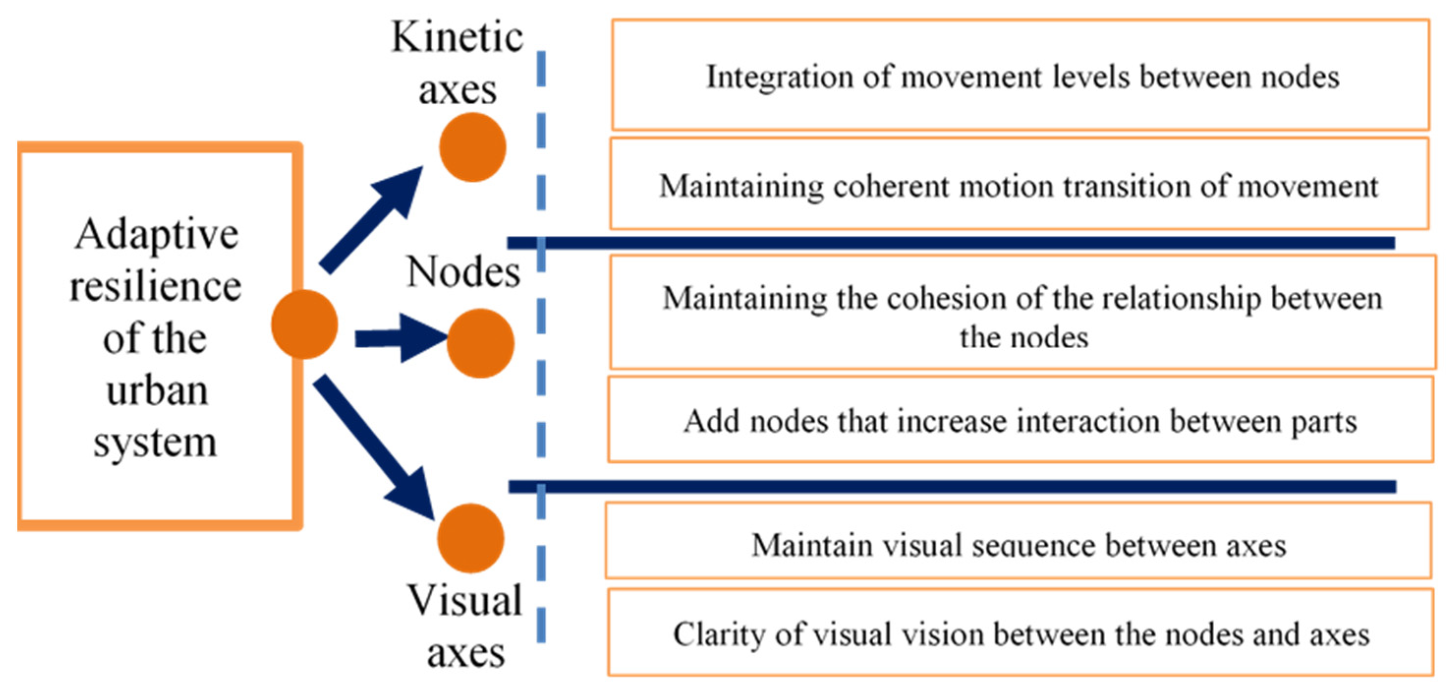
An adaptable urban system depends on the interconnection of the visual and kinetic axes, as well as the connecting nodes. Additionally, these interconnections demonstrate the degree of perfection that the system is meant to achieve to achieve adaptive flexibility and maintain ideal complexity, as shown in Figure 1.
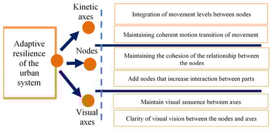
Figure 1.
The effect of kinetic interconnectedness on the adaptive flexibility of the urban system along with the most essential effective indicators.
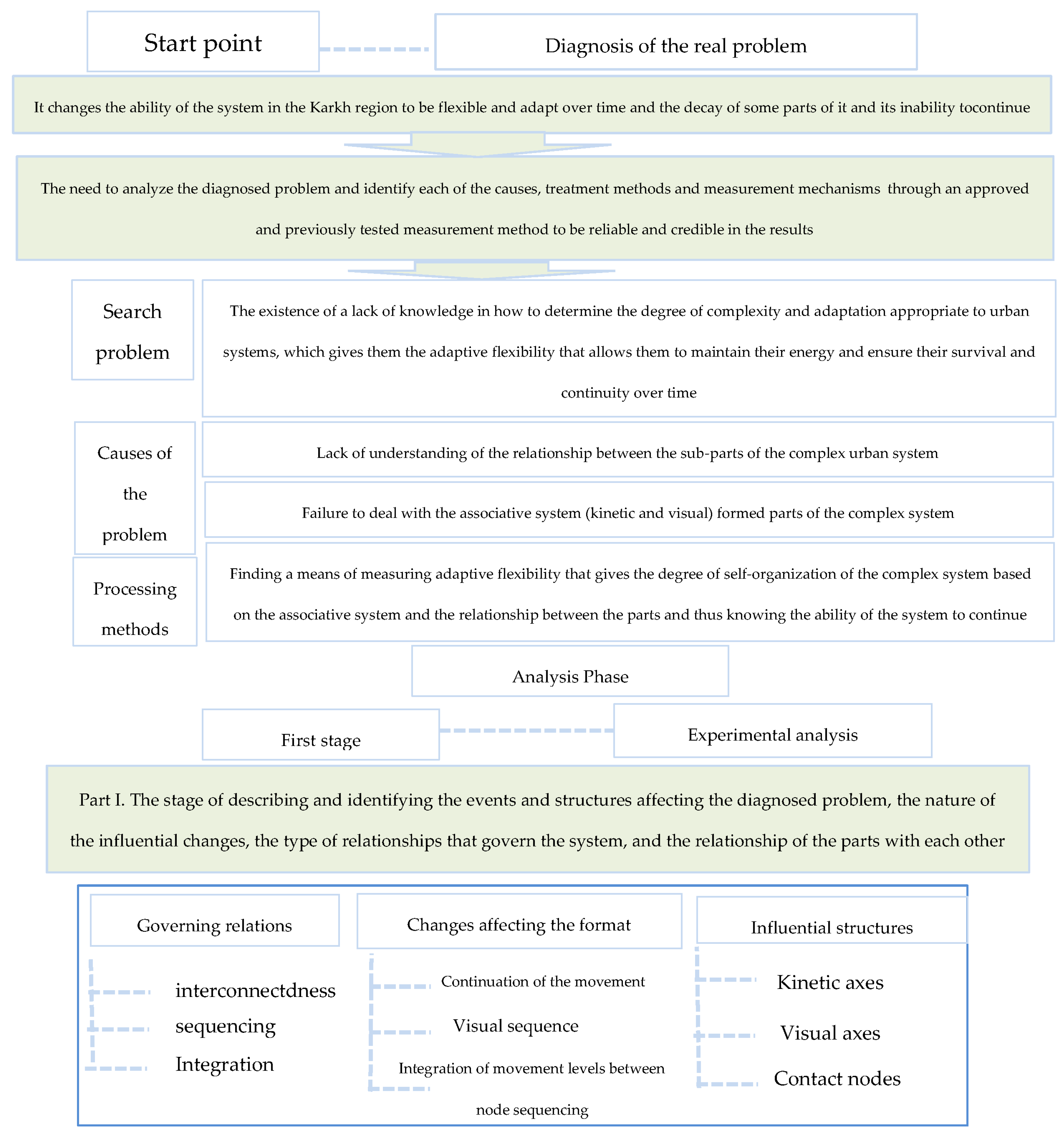
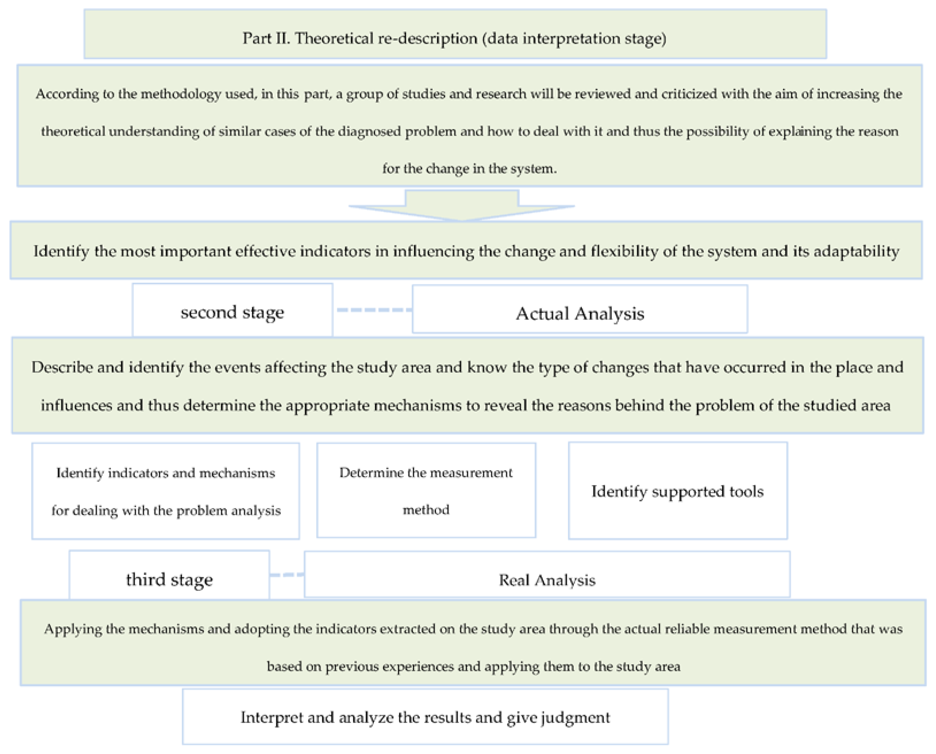
3. Methodology and Tools
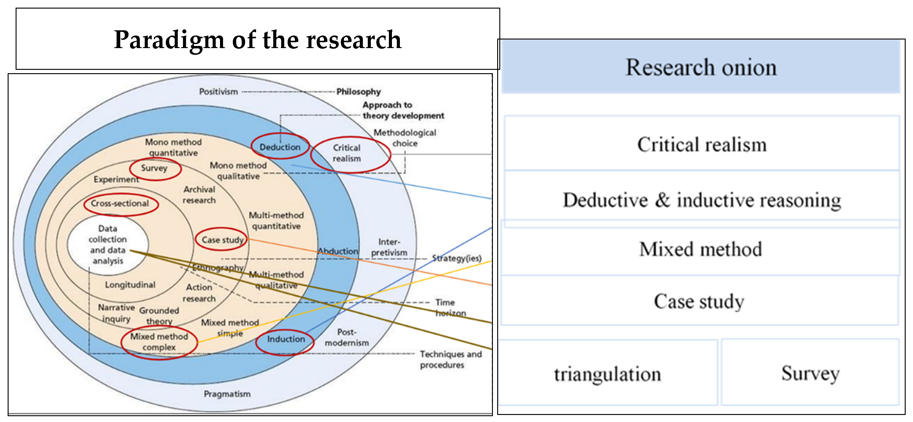
Critical realism is followed in this paper to approach the problem of the research and to achieve the aims of the study. Critical realism depends on reality-based theorization, previous studies, the determination of a factual problem, and the adoption of a previous tool to solve a new problem. Such an approach is applied and tested to obtain findings, analyze data, and discuss results. This methodology is chosen because it uncovers the invisible structures that generate city-affecting events, as shown in Figure 2.
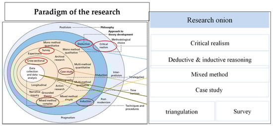
Figure 2.
Onion-based research methodology.
Regarding the tools adopted for analyses, the observation method was relied upon to collect data. This research relied on indirect observations based on documents, records, and development reports of the area examined, prepared by the Baghdad Municipality, in addition to direct observations made by visiting the site and identifying factors that affect the nature of the system and development. Then, the maps obtained were drawn in AutoCAD software 2007, and the kinematic and visual axes of the place were analyzed while calculating the existing nodes, area, and perimeter and the number of axes and their lengths within the software.
In this methodology, a set of steps is followed according to critical realism and adopted as a basis in the research, which starts from the first step, which is to identify the concrete problem from reality. The research steps are as follows: as shown in Figure 3.
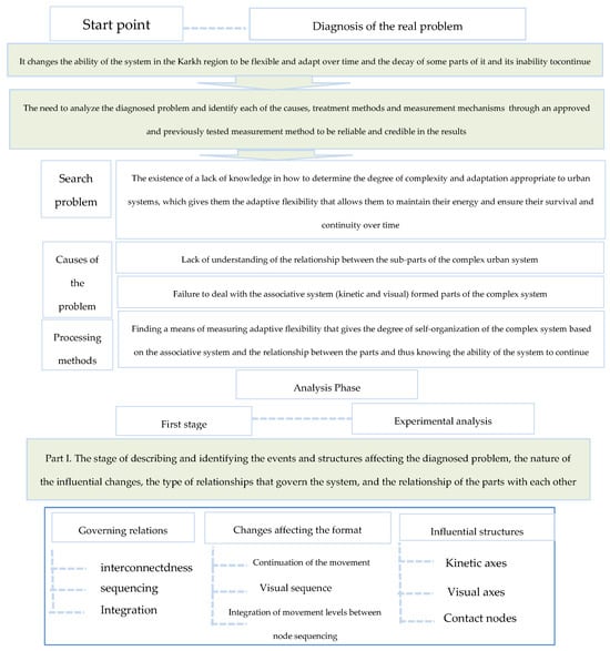
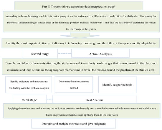
Figure 3.
The research steps.
4. Study Population
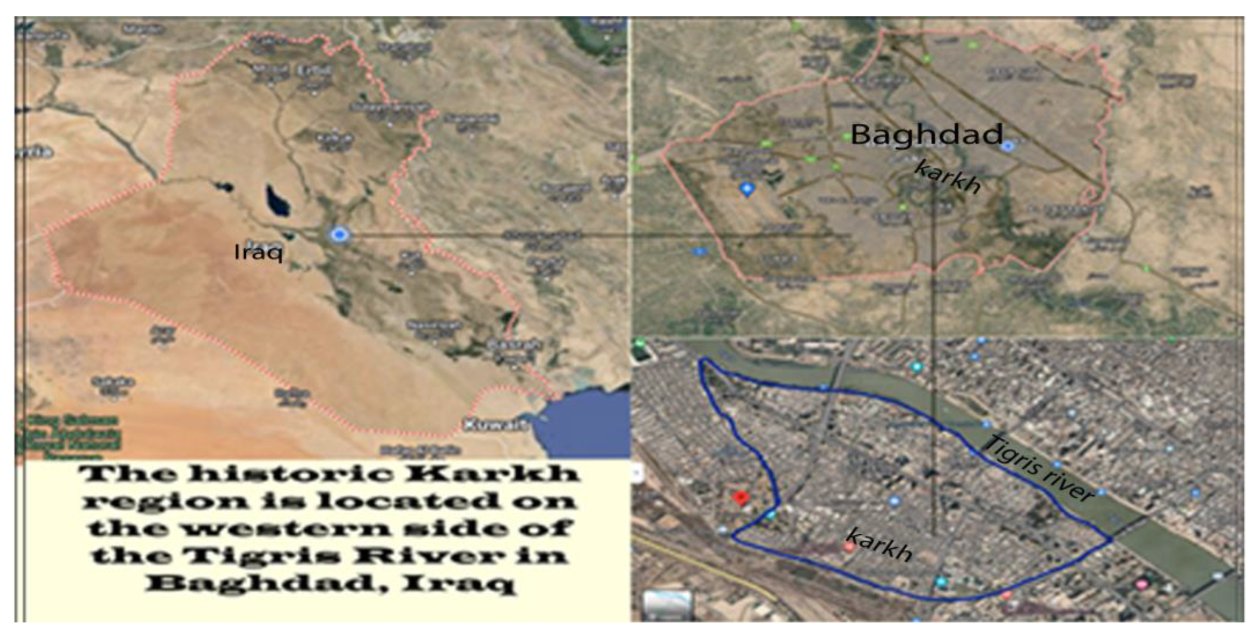
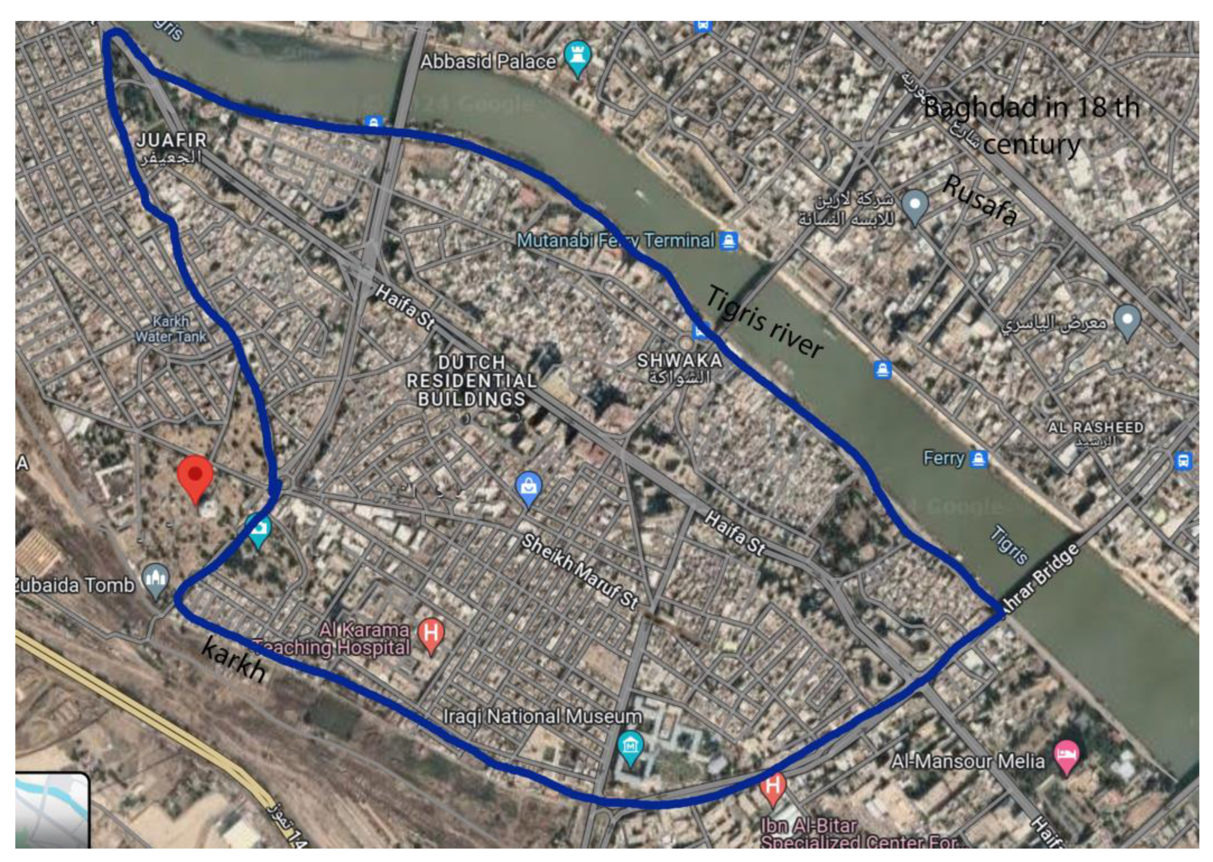
Al-Karkh area was selected to measure the adaptive flexibility of the complex system found in this area located in the city of Baghdad (Figure 4).

Figure 4.
An aerial view of the Karkh area, Google Map.
5. Data and Source
The sample comprises nonrandomized, intentional data representing Baghdad’s Karkh, specifically an area overlooking the Tigris between the Ahrar Bridge and the 14 July Bridge.
Given the many changes made to the system, this study attempted to reveal whether the structures are flexible enough to adapt. With that part of Baghdad being under study, pre- and post-urban changes were taken into account.
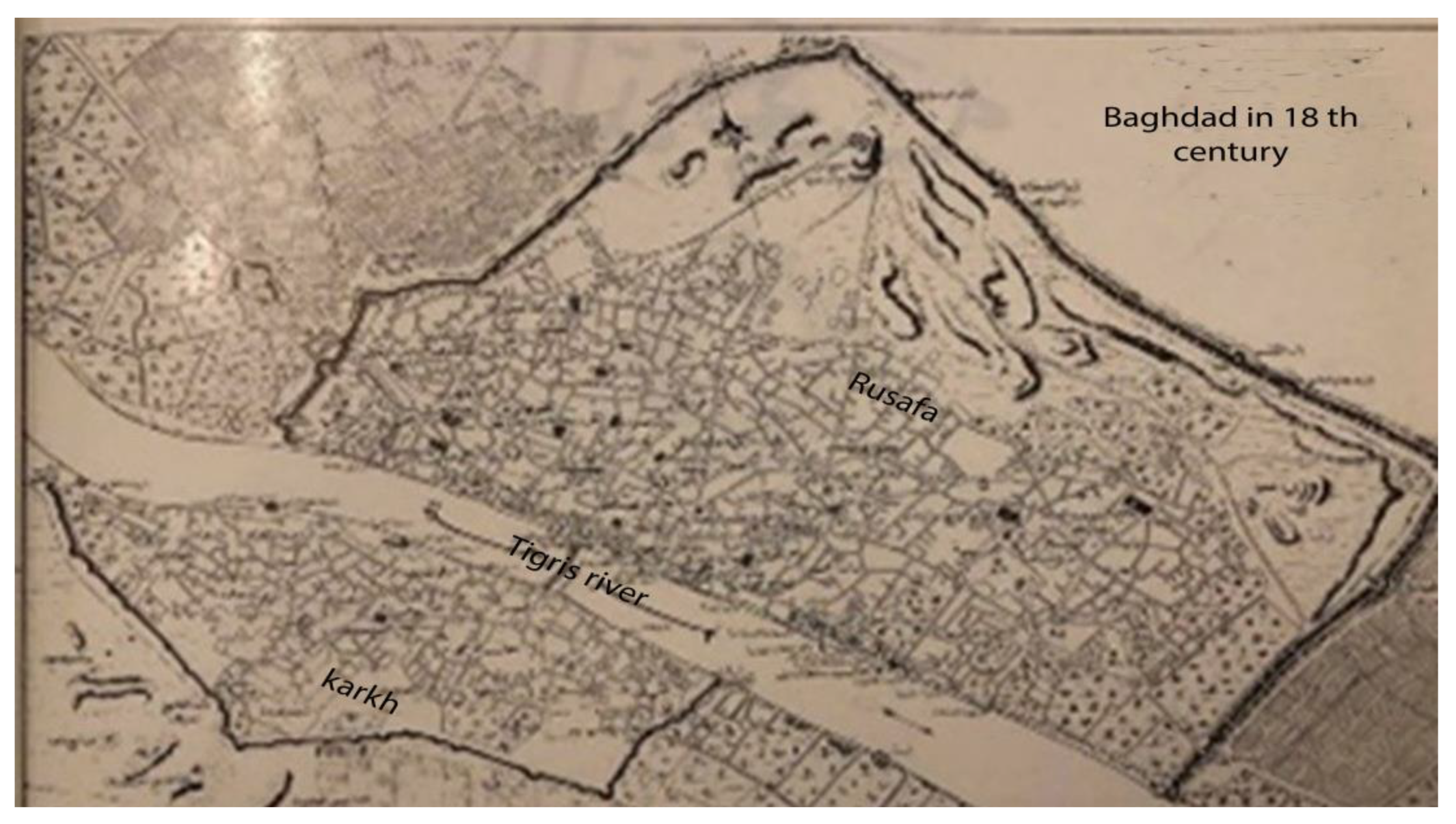
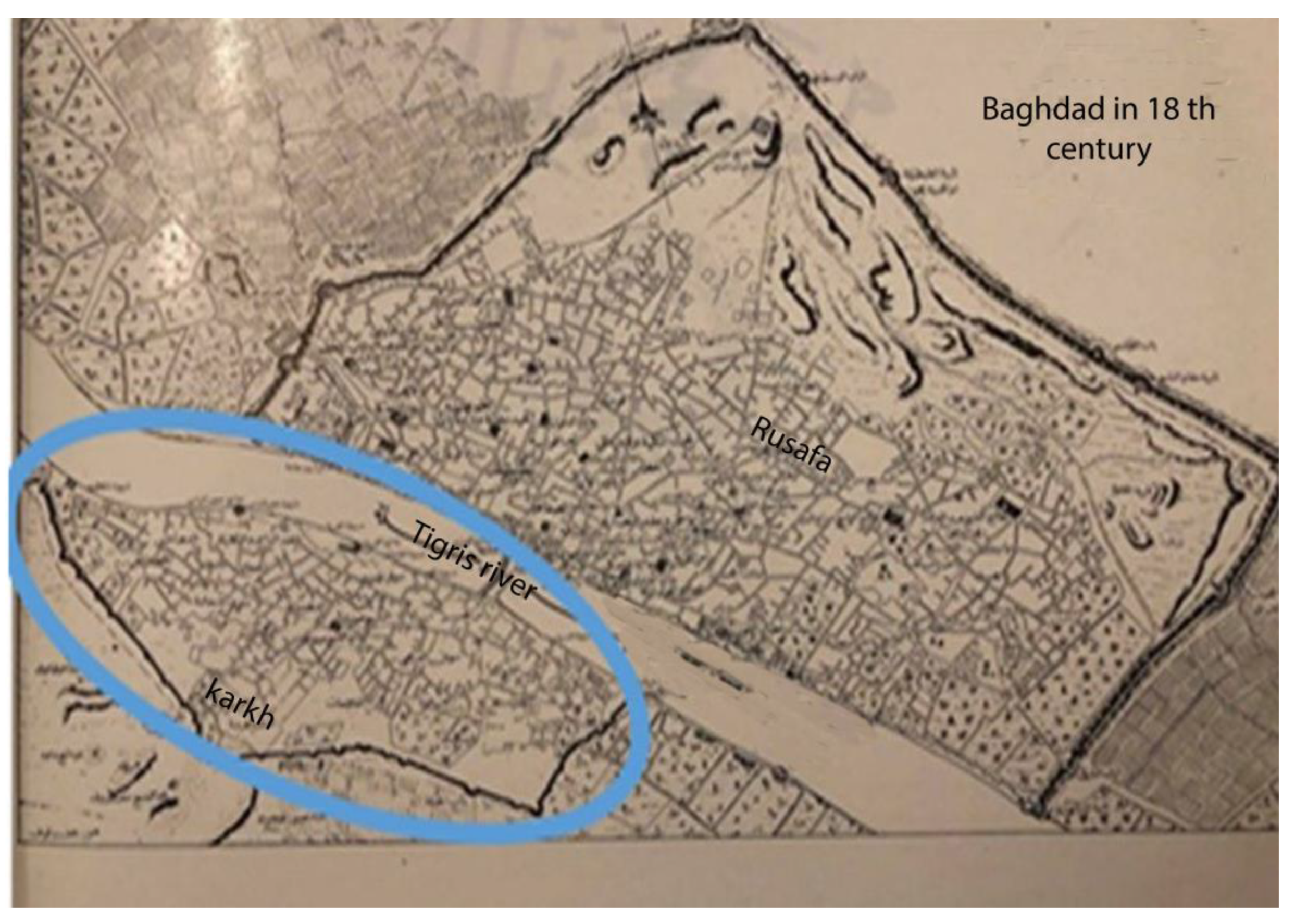
This part has been home to multiple urban, kinetic, visual, and other activities; thus, different texture-impacting changes and trans-systems have taken place. These changes have also resulted in a complex system that requires an analysis to determine how flexibly adaptable the contained parts are, as shown in Figure 5 and Figure 6.
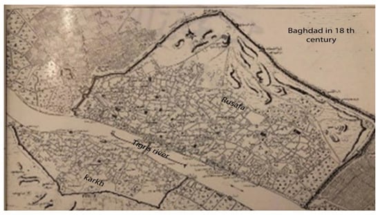
Figure 5.
Map of Baghdad Karkh region in the 19th century, source [6].
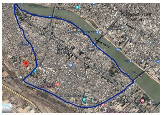
Figure 6.
Map of Baghdad Karkh area at the present Google Earth.
6. Measurement Method
To achieve interaxis integration, some formulas, approved by [12] and previously applied to multiple cases, were used. This method calculates system adaptability based on the interaxis linkages existing between the nodes, in addition to determining both the area and perimeter. This determination designed the ideal adaptability of the system, represented by a value of 1. This method, therefore, was used and applied to Baghdad’s Karkh. The formulae are stated in [16].
A: Total area within the whole visual field (zone or field of influence).
N: Total number of vertices within the whole visual field.
L: Total connections’ lengths (excluding those which surround solids or penetrate internal open spaces).
V: Number of all probable, extended, and visual connections that link vertices altogether (excluding those that surround solids or penetrate internal open spaces holes).
S: Number of all probable physical segments of direct connections that link each pair of adjacent vertices within the whole visual field (excluding those which surround solids or penetrate internal open spaces holes).
P: Perimeter length (excluding those that surround solids or penetrate internal open spaces).
DA: Adaptive dimensions (DA).
7. Practical Application
After an AutoCAD-assisted identification and demarcation of the sampled area, the requirements of the formula set to measure the flexible, adaptable system (the number and the lengths of the kinetic and visual axes, the number of urban-forming nodes, and the area and perimeter of the studied area) were determined.
Then, the formula was applied to realize the system’s adaptability for two time spans, during which potential changes were physically introduced into the system. The values obtained from the two situations were contrasted, and the system (in)adaptability was verified based on the ideal value of the adaptable system, which is 1, as stated in Al-Kasibi [12].
7.1. Nineteenth Century-Era Karkh
7.1.1. Calculating the Complex Adaptive System of the Karkh Region
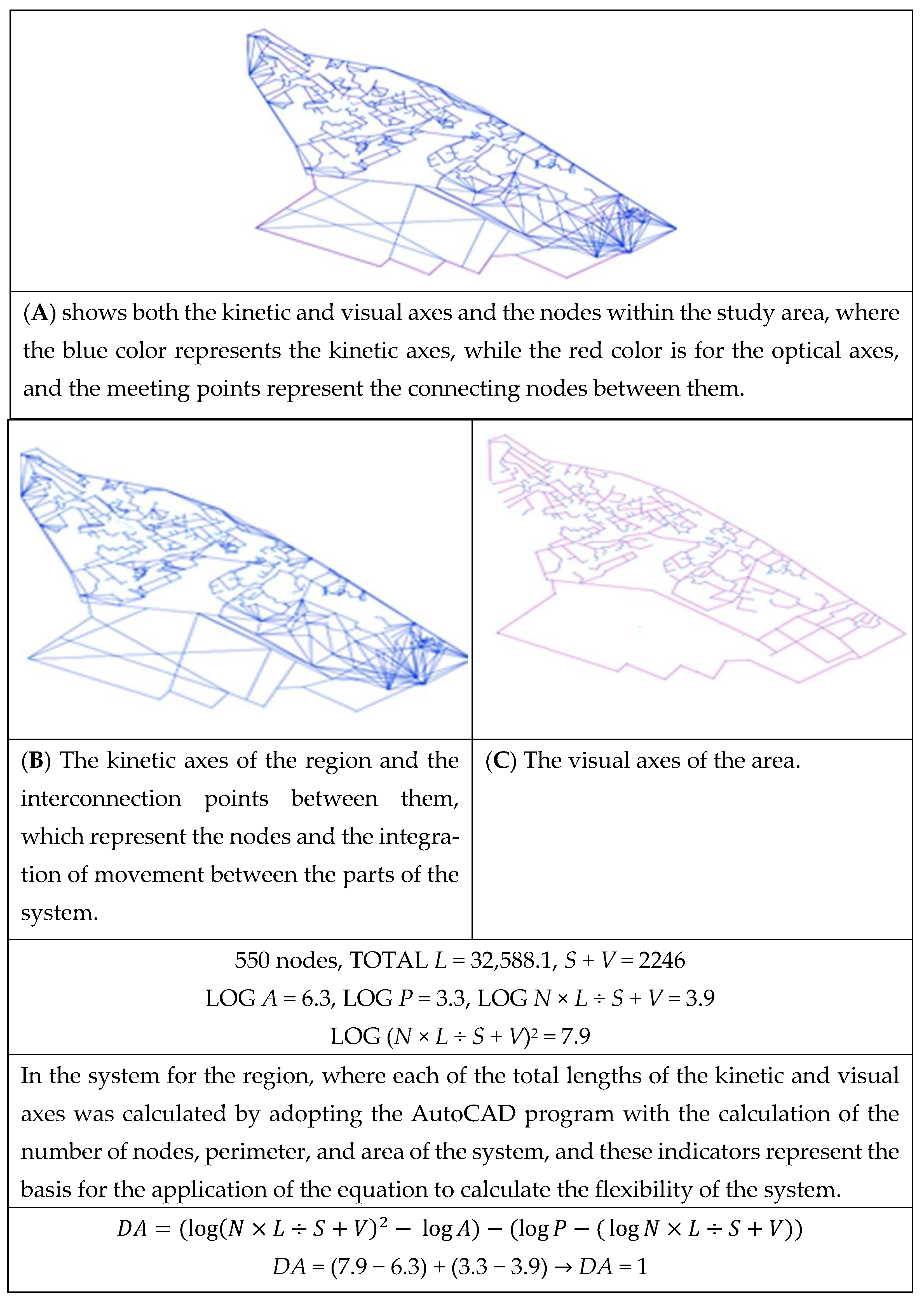
This is the period during which Karkh was populated and urbanized. The area was analyzed after the kinetic/visual axes, as well as linkage nodes, were defined. In addition, interaxis correlations were calculated as per the formula and the value was reached to determine the then-system adaptability.
The axes were calculated as shown in Figure 7, which is an AutoCAD-drawn map.
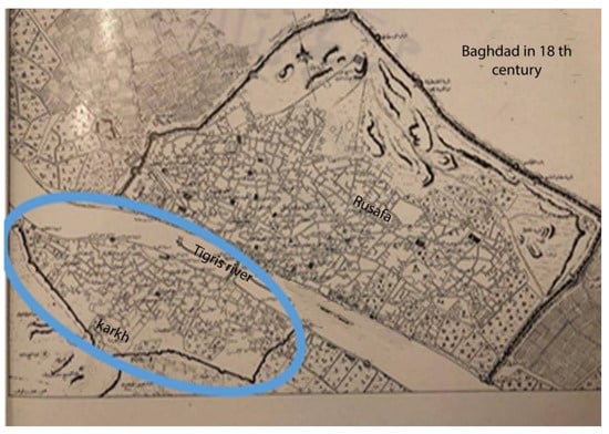
Figure 7.
Nineteenth century-era Karkh [6].
7.1.2. Calculation of the System Adaptability of the Emerging Karkh
The system’s adaptability was analyzed and calculated based on the identification of the intrasystem kinetic axes. The numbers and lengths of the axes and the interaxis linkages were measured using AutoCAD.
Additionally, intra-axis visual nodes were determined, measured, and gathered for processing using the formula of system adaptability and flexibility, as shown in Figure 8.
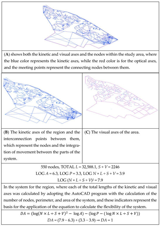
Figure 8.
The stages of calculating the elasticity of the adaptive system of the Karkh region in the period of evolution.
7.2. Present-Day Karkh
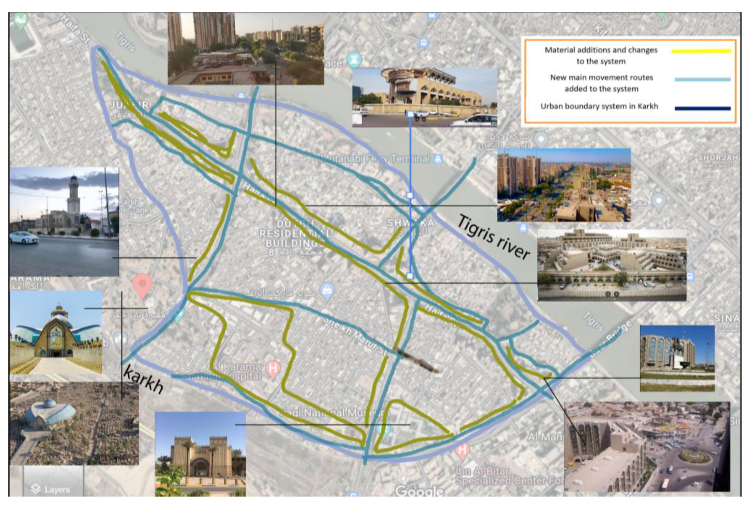
7.2.1. Calculating the Complex Adaptive System of the Karkh Region Currently
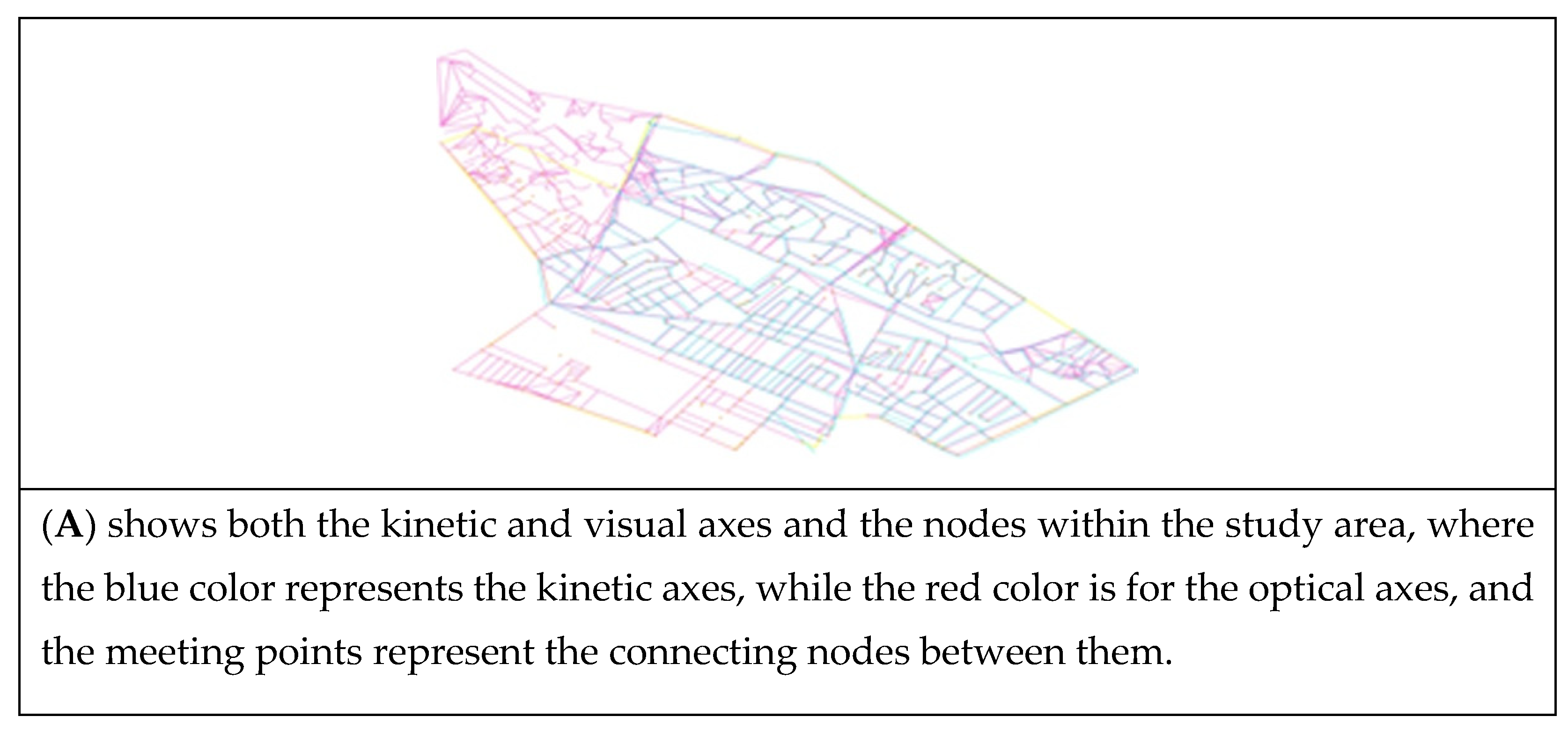
In this stage, the same system was analyzed after having undergone many changes, such as the construction of new roads, changes in kinetic pathways, and the addition of buildings and elements. These developments accordingly led to a change in some kinetic pathways and the interruption of some visual axes. Therefore, there is a need to analyze the area and determine how impactful these factors are, as shown in Figure 9.

Figure 9.
The analysis at this stage: The same system was analyzed after experiencing many changes, which were represented by the construction of new roads, changing movement paths, and adding buildings and elements that led to changing some kinetic paths and interrupting some visual axes due to the added elements, which led to the need to analyze the area and determine the impact of these changes.
7.2.2. Calculation of the System Adaptability of the Emerging Karkh
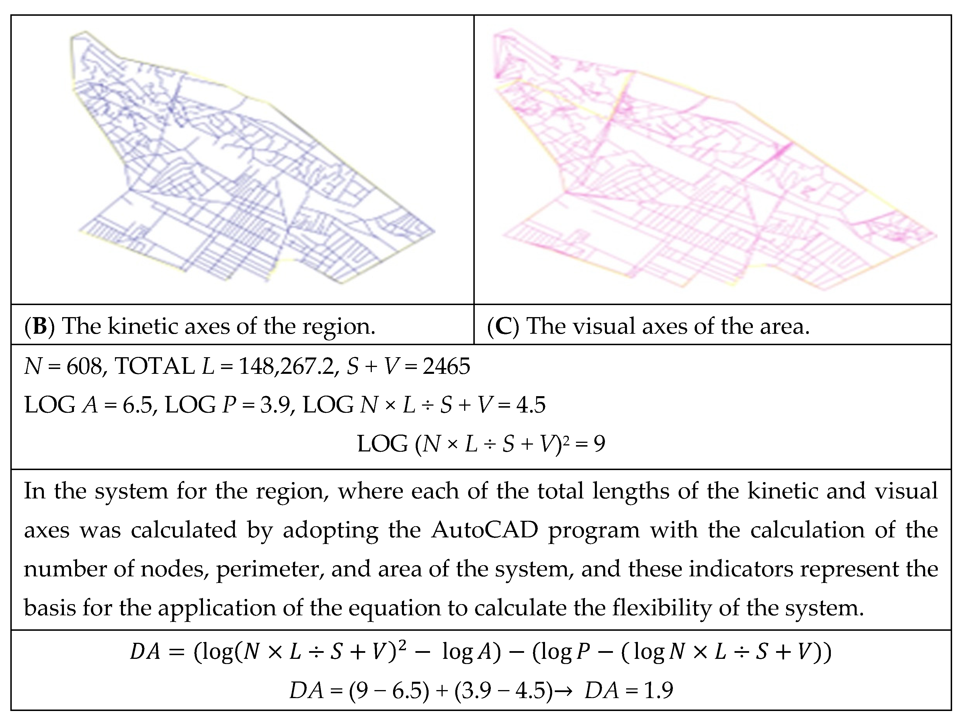
The system’s adaptability was analyzed and calculated based on the identification of the intrasystem kinetic axes. The numbers and lengths of the axes and the interaxis linkages were measured using AutoCAD.
Additionally, intra-axis visual nodes were determined, measured, and gathered for processing using the formula of system adaptability and flexibility, as shown in Figure 10.
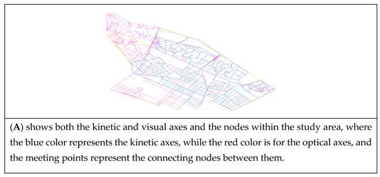
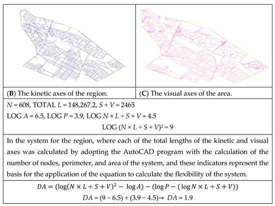
Figure 10.
The stages of calculating the elasticity of the adaptive system of the Karkh region in present-day Karkh.
8. Statistical Computation
Following an AutoCAD-assisted creation of drawings, a mathematical formula, stated earlier in this paper, was used, and then the formula-realizing values were processed in a Microsoft Excel spreadsheet.
9. Results
This study found that system constituent parts featured different adaptations over time, owing to morphological changes in the interconnectedness of the nodes and the hierarchies of their parts.
Self-regulation varied over time as a result of new buildings, which directly affected the interconnected and complete axes.
The results indicate that the pre-modern early system of Baghdad’s historical Karkh was adaptably interconnected, meaning that the system was relevant and interdependent, having carried adaptive dimensions (DA = 1).
This study found that the system fell within the ideal coordinated adaptation. The adaptability suggests dynamic part-oriented integration and internode interconnectedness. The axis-level interventions, and the enforced innovations and structures, such as many physical elements and buildings, dominated the system and the intrasystem visual axes, overlooked the inherited parts, and severed interpart physical and visual relationships. This associative system led to the strengthening of the system so that it became integrated parts, regular and adaptive to each other.
These changes cut short the flexibility of urban complexity, which reached DA = 1.9. In other words, the system, due to interventions, is no longer adaptable. Therefore, the associative system of the complex urban system directly affects the determination of the adaptive state of the system and, thus, determines its ability to survive and continue, as it greatly affects the statement of the strength of this system and its ability to develop and contributes to the possibility of strengthening the relations between its parts and identifying the best flows that contribute to the interdependence of the parts of the system and their self-organization.
10. Conclusions
Structural flexibility is greatly affected by the nature of the associative system between the secondary parts that make up the general urban system, as it expresses the adaptive state through the degree of relational integration between the nodes and the axes linking them, which expresses the extent of the ability of the system to survive, develop, and continue in order to maintain the complexity characteristics. This is achieved by maintaining optimal coherence between the nodes that make up the parts of the system, resulting in adaptive structures capable of self-regulation for survival and continuity. As a result, it is necessary to consider the sudden changes and unstudied interventions that occur in the format. This includes closing or opening the new axes and adding structures that obscure or hinder the continuity of the relationship between the parts within the same format, which can cause the format to move away from its adaptive state by measuring the complexity of the system and knowing the impact of new additions on the strength or weakness of the interconnection between the parts. Therefore, it is essential to consider the evolutionary age of the format and the relationships between its parts, as well as the relationships between visual and kinetic axes, as a key point in maintaining systemic flexibility. This process also involves reading the format from bottom to top and through the parts down to the overall format across multiple time periods to identify the points of imbalance. It is important to identify pathways and unadapted parts to partially address them rather than interventions that may affect the urban system as a whole. All of this depends on determining the degree of complexity and appropriate adaptation, which is determined through the interconnection system between the subparts that make up the complex system. Where the kinetic and visual system affects the cohesion of urban parts and their interdependence with each other, enhancing their ability to survive and develop and providing the possibility of dealing with development projects in terms of strengthening their link with other formats or integrating them within the general system is important.
Author Contributions
Conceptualization, S.A.A.R. and W.S.A.-H.; methodology, S.A.A.R. and W.S.A.-H., software, S.A.A.R.; validation, S.A.A.R., W.S.A.-H. and M.F.S.; formal analysis, S.A.A.R.; investigation, S.A.A.R. and W.S.A.-H.; resources, S.A.A.R., W.S.A.-H. and M.F.S.; data curation, S.A.A.R.; writing—original draft preparation, S.A.A.R.; writing—review and editing, S.A.A.R., W.S.A.-H. and M.F.S.; visualization, S.A.A.R., W.S.A.-H. and M.F.S.; supervision, W.S.A.-H. and M.F.S.; project administration, S.A.A.R. and W.S.A.-H. All authors have read and agreed to the published version of the manuscript.
Funding
The APC was funded by Ajman University.
Data Availability Statement
The original data are available from the authors upon request.
Acknowledgments
The authors would like to express their gratitude to Ajman University for APC support.
Conflicts of Interest
The authors declare no conflict of interest.
References
- Marshall, S. Cities Design and Evolution, 1st ed.; Routledge: London, UK; New York, NY, USA, 2008; p. 130. [Google Scholar] [CrossRef]
- Hillier, B. The Now and Future of Space Syntax: From Structures and Models to Theory. In Proceedings of the The Ninth International Space Syntax Symposium, Seoul, Republic of Korea, 31 October–3 November 2013; Volume 33, pp. 65–70. [Google Scholar]
- Miguel, M.A.G. Explorations on an Urban Interventions Management System. 2019. Available online: https://rgu-repository.worktribe.com/output/841507 (accessed on 11 July 2019).
- Nes, V.; Nes, A.V. What Is the Explanatory Power of Space Syntax Theory? The Application of Modal Logics from the Theory of Science What is the Explanatory Power of Space Syntax Theory? The Application of Modal Logics from Theory of Science. In Proceedings of the 11th Space Syntax Symposium, Lisbon, Portugal, 3–7 July 2017. [Google Scholar]
- Al-Hinkawi, W.S.; Youssef, S.S.; Abd, H.A. Effects of Urban Growth on Street Networks and Land Use in Mosul, Iraq: A Case Study. Civ. Eng. Archit. 2021, 9, 1667–1676. [Google Scholar] [CrossRef]
- Al-Saaidy, H.J. Perspective Chapter: A Conceptualization of Measuring People’s Activity in Sustaining Urban Life. In Sustainable Regional Planning; IntechOpen: London, UK, 2022. [Google Scholar] [CrossRef]
- Nilsson, F. A Complex Adaptive System Approach on Logistics. 2003. Available online: https://lucris.lub.lu.se/ws/portalfiles/portal/5572329/1030967.pdf (accessed on 11 March 2024).
- Dovey, K. Informal urbanism and complex adaptive assemblage. Int. Dev. Plan. Rev. 2012, 34, 349–367. [Google Scholar] [CrossRef]
- Hammoodi, S.A.; Al-Hinkawi, W.S. The role of spatial value in the reconstruction of religious buildings Mosul city—A case study. Ain Shams Eng. J. 2023, 14, 102164. [Google Scholar] [CrossRef]
- Walker, B.; Salt, D. Resilience Thinking, Sustaining Ecosystems and People in a Changing World; Island Press: Washington, DC, USA, 2006; Available online: https://faculty.washington.edu/stevehar/Resilience%20thinking.pdf (accessed on 11 March 2024).
- Neal, Z.; Rozenblat, C. Handbook of Cities and Networks; Edward Elgar Publishing: Cheltenham, UK, 2021; ISBN 978. [Google Scholar] [CrossRef]
- Al-Kasibi, H.A. A new concept of adaptive complexity. Period. Eng. Nat. Sci. 2020, 8, 1687–1700. [Google Scholar] [CrossRef]
- Salingaros, N. Complexity in Architecture and Design. Oz 2014, 36, 4. [Google Scholar] [CrossRef]
- Boeing, G. OSMnx: New methods for acquiring, constructing, analyzing, and visualizing complex street networks. Comput. Environ. Urban Syst. 2017, 65, 126–139. [Google Scholar] [CrossRef]
- Jiang, B. New Paradigm in Mapping: A Critique on Cartography and GIS. Abstr. Int. Cartogr. Assoc. 2019, 1, 150. [Google Scholar] [CrossRef]
- Al-Guesbi, H.A. Well-Organized Complexities: A New Theory of Life. IOP Conf. Ser. Mater. Sci. Eng. 2021, 1090, 012134. [Google Scholar] [CrossRef]
- Ali, S.H.; Sherzad, M.F.; Kadhim, A.H. Managing Strategies to Revitalize Urban Cultural Heritage after Wars: The Center of the Old City of Mosul as a Case Study. Buildings 2022, 12, 1298. [Google Scholar] [CrossRef]
Disclaimer/Publisher’s Note: The statements, opinions and data contained in all publications are solely those of the individual author(s) and contributor(s) and not of MDPI and/or the editor(s). MDPI and/or the editor(s) disclaim responsibility for any injury to people or property resulting from any ideas, methods, instructions or products referred to in the content. |
© 2024 by the authors. Licensee MDPI, Basel, Switzerland. This article is an open access article distributed under the terms and conditions of the Creative Commons Attribution (CC BY) license (https://creativecommons.org/licenses/by/4.0/).