Abstract
The Huizhou region is an important area of traditional Chinese culture, and currently, the state of the village’s surroundings in this area is still not perfect. In this study, seven districts (counties) in the Huizhou region were selected for research. The Rural Habitat Environment (RHES) Indicator Program is based on the concept of Socio-Economic-Natural Complex Ecosystems (SENCE) and constructs 18 metrics in three dimensions. Trends and influencing factors were analyzed using entropy weight TOPSIS and a Grey Relational Analysis (GRA) for the years 2013–2022, and spatial and temporal evolution was measured using Geographic Information Systems (GISs). The findings show that the composite index for the Huizhou region grew from 2013 (0.3197) to 2022 (0.6806). Second, the Tunxi District belongs to the high index–high economy category. The Shexian, Xiuning, and Qimen counties belong to the high index–low economy category. Huizhou District and Huangshan District belong to the low index–high economy category. Yixian County belongs to the low index–low economy category. Third, all districts (counties) show an upward trend, and Huangshan District has the best RHES condition. Shexian County ranks relatively low in the comprehensive index.
1. Introduction
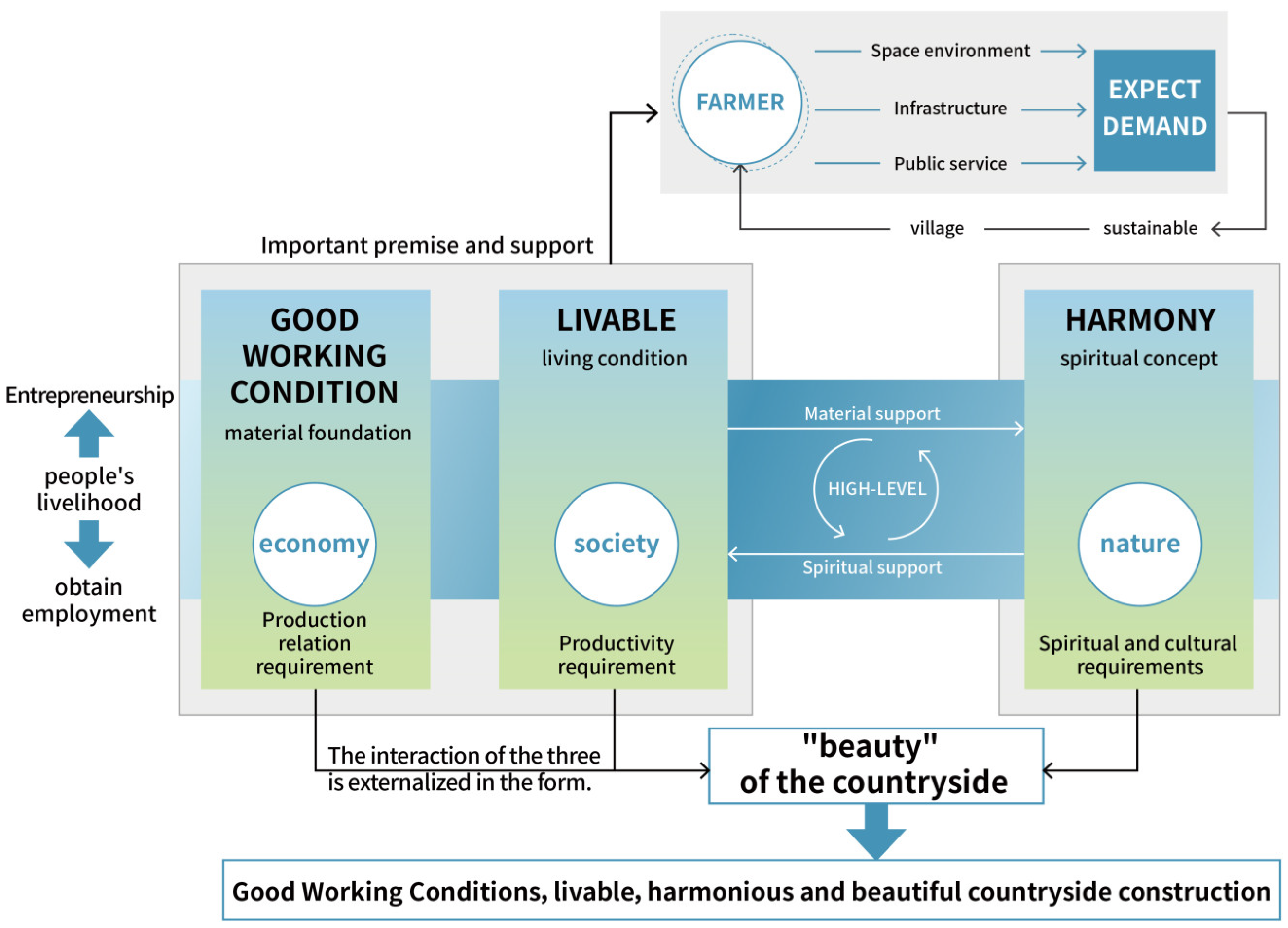
The RHES is a general term for the natural, economic, social, and cultural environments related to human residential life within a rural space [1]. In practice, it refers to the organic combination of the material and non-material needs of farmers in their productive lives [2,3]. Good working conditions are the material foundation. The term livable represents living conditions. Harmony is a spiritual concept. The interaction of these three factors is externalized, representing the “beauty” of the countryside (Figure 1). The concept of “harmony and beauty” incorporates the traditional Chinese culture of “harmony” and reminds people that beauty is not only about appearance.

Figure 1.
Logical relationship between “livable, workable and beautiful countryside”.
Environmental livability refers to living conditions, focusing on infrastructure and public services. An area with environmental livability is a settlement with a good spatial environment and a humanistic and social environment with modern living conditions [4]. From the perspective of production relations, rural construction is carried out for farmers to meet their expectations and requirements for rural living conditions and a good living environment [5]. “Livable” means farmers can live a modern life where they are residing and realize sustainable ecological livability [6].
Good working conditions depend on industrial and economic development. Areas that are suitable for entrepreneurship and employment [7] can create more local and nearby employment opportunities for farmers. Providing a material foundation for farmers to lead a modern life is a good way to liberate and develop rural productivity and realize farmers’ prosperity. From the perspective of productivity development, without supporting materials, rural construction can only be carried out at a low level.
Life and beauty are spiritual concepts that highlight the intrinsic attributes of spiritual civilization. This means having a stable and harmonious social environment. “Beauty” is the external appearance of material civilization. From the perspective of spiritual culture, the idea of beauty provides a conceptual guarantee and a spiritual kernel for rural construction [8]. It is an important concept in traditional Chinese culture, emphasizing the harmonious relationship between people, nature, and society.
2. Synthesis of Research
Well-being is understood as welfare, advantage, and benefits [9]. Well-being continues to represent the degree to which conditions are maintained and improved in all areas. The level of well-being of people depends on their living conditions and the degree of economy. A high level of well-being is measured using the Human Settlement Environment (HSE) index [10,11]. National development for the promotion of people’s well-being enhances residents’ senses of acquisition, happiness, and security.
To promote people’s well-being, the state has taken the growth of people’s demand for a better life as its core objective [12]. Research has shown that China’s studies on the effects of health, safety, and environmental well-being have mainly focused on more developed urban areas. However, the unbalanced and insufficient development of urban and rural areas is a major challenge in Chinese society. Rural areas have long been a weak link in national development [13]. Farmers face low income levels, low labor productivity, a lack of public service facilities, and backward environmental governance in contrast to the prosperity of cities [14]. In view of this, the well-being of rural residents in China needs to be assessed and studied in depth.
The geographic work conducted by geographers on the concept of well-being is valued from the perspectives of psychology and welfare economics. Simandan presents a perspective on geography in personal and social change, emphasizing the role of the unexpected and surprising in shaping personal well-being and social change [15]. Furthermore, Smith and Reid explore the role of presence in the construction of well-being and how it relates to geographies of health and well-being [16]. By integrating these critical geographic perspectives, this study extends the understanding of the differences in well-being between rural and urban residents, emphasizing the importance of space and place in shaping lived experiences and perceived well-being. These geographic perspectives provide frameworks to reassess and reinterpret data while offering new directions for future research to explore how spatiality affects human well-being.
The HSE in Huizhou has the advantages of having natural beauty, a pleasant climate, a rich culture, and a quiet atmosphere. On the one hand, it provides a livable environment for rural residents and attracts many tourists to explore and experience the area. On the other hand, it benefits the well-being of residents while promoting local economic prosperity and social progress. Although the Huizhou region possesses several advantages, there is also a series of unfavorable conditions in terms of the HSE. The Huizhou region is in the mountainous area, and the terrain is mostly hilly and mountainous, which affects residents’ traveling abilities and the transportation of materials. The regionalization of rural areas in Huizhou varies greatly, resulting in a mismatch between the HSE and infrastructure development [17]. An excessive influx of tourists and residents may affect the original ecological environment and cultural heritage [18].
RHSE includes a variety of elements associated with an individual’s residential environment. They are commonly categorized into the following four types: The first type is rural buildings and infrastructure [19]. This factor mainly includes buildings, commercial facilities, roads, bridges, water, electricity, and gas infrastructure. The planning, design and construction of these facilities should consider the needs, safety, and sustainability of residents. The second type is rural housing [20]. The RHES involves different types of housing styles, such as bungalows, village-style buildings, and buildings. This includes the layouts, sizes, and functions of the houses as well as the planning and design of residential areas. The third type is community facilities [21]. The RHES also includes community facilities, such as education, healthcare, transportation, and elderly care. The existence and quality of these facilities are essential to provide convenience, promote social interaction, and enhance quality of life. The fourth type is the rural natural environment and green spaces. The HSE should be harmonized with the natural environment [22]. The presence of green spaces and natural landscapes helps to improve air quality, regulate climate, provide recreational space, and promote ecological balance.
The current academic research on the RHES from a GIS perspective focuses on the definition, meaning, and dynamic evolution levels. First, the RHES can be defined as a livable countryside that people living in the city would envy. A livable countryside makes industries more prosperous. A harmonious countryside makes farmers’ homes happier. The RHES is a modern living condition that can satisfy farmers’ material consumption needs and spiritual life pursuits. Industry, talent, culture, ecology, and the organization of the overall coordinated development of the countryside are factors involved in achieving a livable countryside [23]. Second, the important value of the RHES, from the perspective of Chinese-style modernization, constitutes the inherent requirements and prerequisites for the construction of a strong agricultural country and has both far-reaching historical and practical significance. Third, there has been dynamic evolution in the process of building a livable, workable, and beautiful countryside [24]. Since the 1990s, with the introduction of new technologies such as computers and GISs, quantitative research methods have become mainstream in the field of RHES research.
The RHES is a complicated dynamic megasystem [25], and establishing livable and beautiful villages is the main aim of the RHES. With the continuous upgrading of the urban and rural economy comes economic pressure. The main directions of comfort and coordination are used to carry out comprehensive evaluations and research on the HSE. They lay the foundation for development to narrow the urban–rural gap and provide data support for green growth in the countryside. Although there are some disadvantages in the Huizhou area, these problems are not insurmountable. Scholars often measure the level of RHES development by constructing an indicator system for a comprehensive evaluation [26]. This study explores the quality of the RHES in Huizhou and investigates its spatial and spatio-temporal patterns of distribution based on existing research results with the help of entropy weight TOPSIS and GRA. It promotes Huizhou to build a development pattern involving harmony and symbiosis among human beings and nature, which, in turn, promotes the sustainable development of the RHES in China.
3. Material and Methodology
3.1. Research Scope
The Huizhou region is a region in the Anhui province of China. The Huizhou region carries rich Huizhou culture, and its political and economic influences have covered a wide area in various historical periods. According to the approval of the State Council in November 1987, the Huizhou Prefecture was reorganized into the prefecture-level city of Huangshan. Jixi County was assigned to the Xuancheng region, and Shitai County was assigned to the Chizhou region. In July 1988, the prefecture-level city of Huangshan was formally established. It includes Huangshan District, Tunxi District, Yixian County, Shexian County, Huizhou District, Qimen County, and Xiuning County (Figure 2).
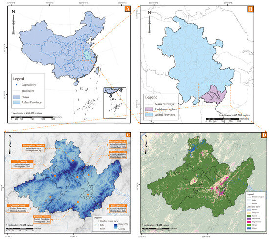
Figure 2.
Regional location of Huizhou.
The HSE in the Huizhou region has numerous advantages that attract residents and tourists to live and visit the region. First of all, the Huizhou region is in a mountainous area with rich natural resources and magnificent natural scenery. Clear lakes, ancient villages, and green mountains constitute the unique natural ecological environment of the Huizhou region. It brings a fresh and pleasant living atmosphere to residents. Secondly, the Huizhou area is one of the more well-preserved ancient village settlements in China with many ancient villages of unique style. The most famous of them are Hongcun, Xidi, Qimen, and so on. Thirdly, Huizhou has a long history and unique Huizhou culture. Preserving many Huizhou-style buildings from the Ming and Qing dynasties, it has become a favorite tourist destination for domestic and foreign tourists.
This shows that the Huizhou area is rich and diverse in ancient villages, traditional handicrafts, and historical and cultural relics. Residents live in a cultural atmosphere and feel the unique historical heritage and cultural essence. The HSE is an important source of happiness and security for residents. Compared with the city, the living environment in the Huizhou area is more peaceful and quieter, and the pace of life is relatively slow. Thus, residents enjoy a peaceful life and have a higher quality of life.
3.2. Research Process
In this study, a comprehensive RHES indicator system was constructed using the SENCE conceptual framework. GRA and entropy weight TOPSIS were selected to measure the level of RHES growth in Huizhou. The process of the study (Figure 3) is described below.
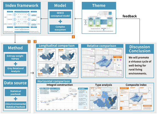
Figure 3.
Processes of research on RHES well-being effects in Huizhou region.
First, the composite ecosystem–SENCE conceptual framework is used. The first task involved in scientifically measuring the level of livable and beautiful countryside construction in the Huizhou region is choosing appropriate measurement indicators. A complete, scientific, and objective evaluation index system is constructed. Second, the collection and compilation of data are carried out. A total of 18 indicators in 7 regions (counties) include three major types of data: social, economic, and environmental. Social and economic data were obtained from the Statistical Yearbook (2013–2022) for each district (county). The data on the environment are from the China Environmental Statistics Yearbook (2013–2022). Third, entropy weight TOPSIS is used to compare the effect gaps between different regions and time through a comprehensive evaluation of the RHES. Composite scores are derived for each subsystem to analyze the variance demonstrated at the substrate layer. Diagnosis of the effectors is carried out using GRA to derive the major factors of influence. The purpose is to obtain information on the rational exploitation and use of rural Huizhou.
3.3. Indicator Construction
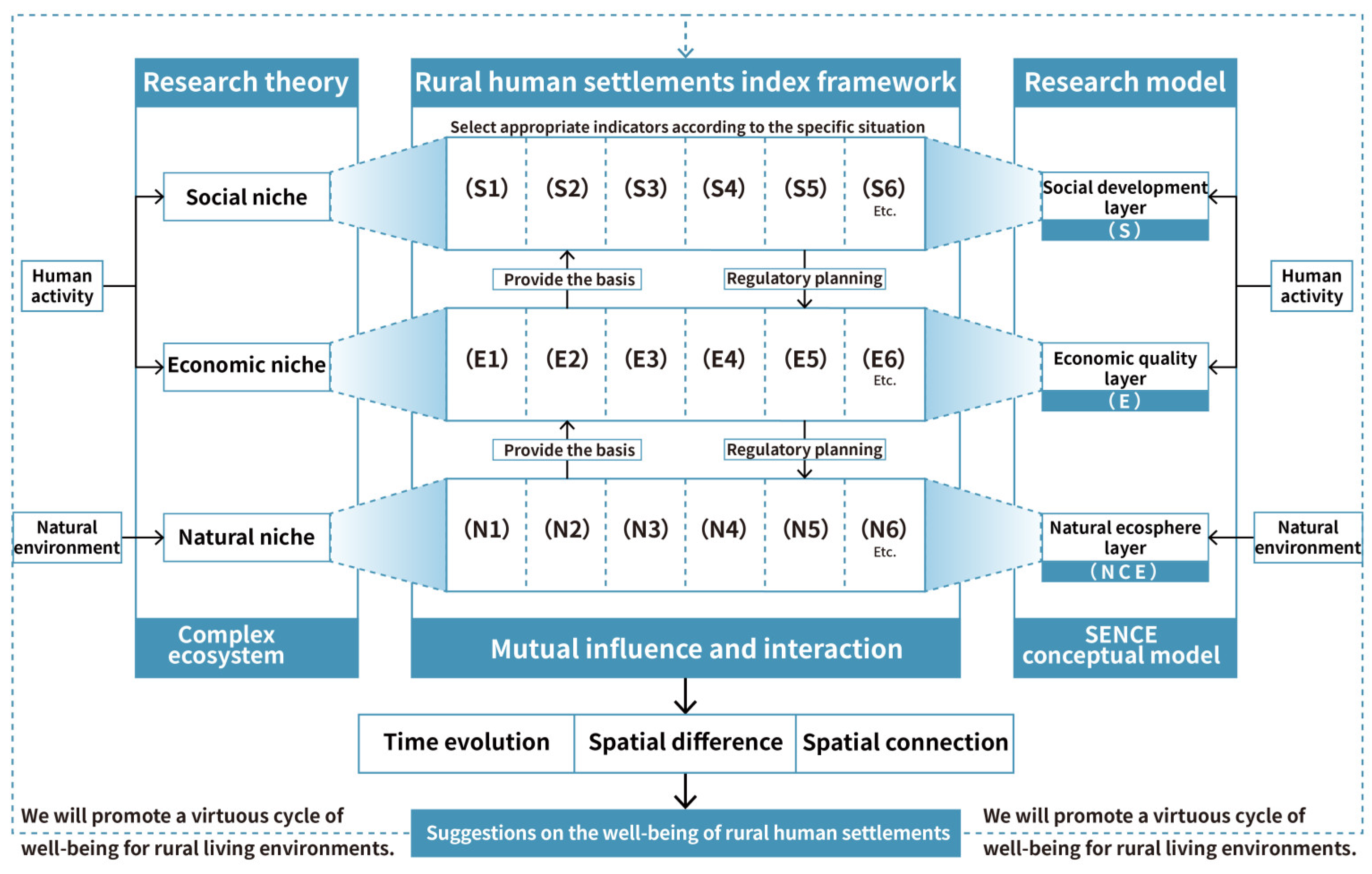
A composite ecosystem will use the HSE to refer to human behavior as the subjective consciousness, the natural environment as the auxiliary conditions, and economic and social needs as the multi-level needs of society, the economy, and nature. It will combine the single economic, social, and ecological fields into a composite ecosystem with vitality [27]. Its core concept is to integrate the internal relationships of the three subsystems. The coupling of high-quality coordinated and interoperable development is emphasized to achieve the sustainability of the composite relationship [28]. The SENCE framework of perception is a unifying body of society, economy, and nature and is known as SENCE—Complex Ecosystems [29]. The SENCE conceptual framework was combined with the concept of a composite ecosystem (Figure 4). The three subsystems were divided according to the principles of targeting, relevance, systematicity, and operability.

Figure 4.
Complex ecosystem–SENCE conceptual framework.
Studies have shown that the SENCE conceptual framework has the advantages of completeness, systematicity, and operability. Firstly, the SENCE conceptual framework embraces key elements such as economy, community, natural resources, and setting. It can accurately represent the connection between ecology and other elements [30]. It provides a scientific theoretical basis for the study of RHES well-being in Huizhou. Second, the environment, agriculture, and ecology domains are integrated into the SENCE framework. This offers a fundamental framework for the establishment of a rational RHES indicator system. Finally, its assessment logic is simpler to understand and use, bringing convenience to researchers. Thus, this research adopts the SENCE conceptual framework as the study model and the composite ecosystem as the study concept. This study constructs a framework of indicators for evaluating the well-being effects of livability and beauty RHES in Huizhou.
The objective layer is the general objective of the indicator framework for the well-being of the RHES in the Emblem area (M). The guideline layer (subsystem) is a subdivision and normalization of the indicator framework’s level of ambition. The indicator elements are organized into three groups, namely social development (S), economic quality (E), and natural ecology (NCE). The indicator level is the concretization of the guideline level and extends the indicators on that basis. Through generalization and screening, the guideline layer is expanded to S1–S6, E1–E6, and N1–N6, totaling 18 secondary assessment indicators (Table 1). The detailed implications of the structure of the guidelines and indicators tier are set out below.

Table 1.
Framework of RHES well-being indicators for Huizhou region.
First, the social development layer (S) responds to the social component of the evaluation index framework, that is, the relationships and community systems that result from human contact, including social connections, cultural identity, public administration, and economic growth. A geographical environment with a common cultural background and social relationship network formed to meet the needs of people’s daily activities, such as residence, consumption, and leisure. The evaluation indicators selected correspond to the number of people in the countryside (S1), the number of village practitioners (S2), village-run health centers (S3), the per capita housing floor area of rural residents (S4), rural electricity (S5), and the number of automobiles per 100 rural households (S6).
Next, the economic quality layer (E) corresponds to the economy sub-system in the evaluation indicator system, that is, all kinds of production and business activities on which human beings rely for survival and development. The level of economic output is the functioning force behind the establishment of the RHES, which is representative of the economic level and living and production conditions in the countryside. The evaluation indicators selected are the per capita income of permanent residents in villages (E1), the per capita consumption expenditure of rural permanent residents (E2), expenditure on rural minimum subsistence allowance (E3), rural employment subsidies (E4), village conservation and building tax (E5), and elements of the gross value of agricultural output (E6).
Third, the natural ecological layer (NCE) responds to the natural sub-systems in the assessment index system. It is the natural substrate for the development of the RHES in Huizhou, which is a geographical place that provides the required ecological products and services for the rural residents of Huizhou. It mainly includes the local climate, topography, water, land, pollution level, and so on. The evaluation indicators selected are the annual average intensity of PM2.5 (N1), the proportion of good and excellent weather in a year (N2), green coverage area (N3), annual precipitation (N4), the annual average temperature (N5), and forest cover (N6). The selected evaluation indicators may express the developing condition of Huizhou’s natural environment and promote Huizhou to build a development pattern of harmonious coexistence between human and nature.
3.4. Data Sources
The data on the objective status of the HSE in Huizhou are mainly derived from sources such as the Huangshan City Statistical Yearbook (2012–2022), the China County Statistical Yearbook (2000–2022), and the CECN statistical database (Table 2). Considering the feasibility of data acquisition and the focus of this study, the 10-year period of 2013–2022 is taken as the evaluation period. To address the issue of missing data, Stata MP software is used to estimate missing values. This method uses the available data to infer the most likely values for missing entries, ensuring that the overall trend and distribution of the data set is maintained.
Table 2.
RHES data sources and descriptions for the Huizhou region.
4. Evaluation Methodology
4.1. Entropy Weight TOPSIS
The entropy weight TOPSIS evaluation model can objectively and comprehensively evaluate the degree of strengths and weaknesses of multiple objects in the same field. By exploring the principle of the superiority and inferiority solution distance method [34], the degree of superiority and inferiority of the HSE status of Huizhou is defined as the comprehensive evaluation value of the objective status. The assessment process includes two steps: indicator assignment and comprehensive evaluation. In particular, the entropy weight approach is utilized to identify the weights of the basic internal indicators, and the TOPSIS approach is utilized to synthesize the evaluation of the research object [35]. The specific steps are outlined below.
If there are items to be assessed and indicators, then we can form the statistics indicator data matrix . values are normalized using the following equation:
The value of when the index is an inverse indicator is as follows:
The normalized data matrix is used to determine the entropy weight of each indicator and is calculated as follows:
The normalized matrix formula, , can be used to obtain Formula (4) as follows:
where .
The composite score for each indicator is obtained by the formula. The formula for the optimal solution is as follows:
The worst solution formula is as follows:
The Euclidean distances between each assessment subject and the positive and negative ideal solutions are calculated, and the composite scores are obtained as follows.
The formula for the distance to the optimal solution is
The distance from the worst solution is given by the following equation:
The relative proximity of each measurement scheme to the ideal scheme is calculated, and the combined score formula is as follows:
When , this represents the highest evaluation level; when , this represents the lowest evaluation level. On the contrary, this also means the RHSE system construction indicators in Huizhou are closer to the optimal solution.
Combining the characteristics of the entropy weight method and the TOPSIS method to supplement each other’s deficiencies and applying them to the construction of a RHES construction assessment system in Huizhou has many advantages. First of all, the entropy weight method is chosen to assign weights to the dimensions to avoid the problem of subjective weighting bias caused by the insufficient understanding of different experts about the environmental governance and the actual development of the region, as well as the problem of insufficient research by HSE scholars on the weights of the evaluation indexes across the urban and rural areas that are unique to Huizhou and the problem of not being able to determine fair weights. Secondly, the choice of using the TOPSIS method was decided based on the reality of rapid and uneven development in Huizhou. Since Huizhou is not only limited to the rural environment and natural geography, its unique cross-rural and urban geographical characteristics make its evaluation objects involve multiple HSE types, and its environmental characteristics are diverse and complex.
At the same time, to analyze the temporal and spatial evolution of the HSE construction in Huizhou, it is necessary to carry out a comprehensive and multi-level study in different regions and years, and entropy weight TOPSIS is chosen based on such a realistic background, considering the complexity of the temporal and spatial changes in the sample data.
4.2. GRA
The gray system theory holds that, in the process of people’s cognition of objective things, people cannot fully grasp all information. Rather, they can only grasp part of the known information, and at the same time, they will also encounter some unknown information or uncertainty factors. Therefore, the gray system theory emphasizes the need to consider these unknown or uncertain factors when dealing with and analyzing problems [36] to understand and recognize these problem more objectively and accurately. Among them, an unknown system is known as a gray system. To explore and measure this unknown gray system, a GRA analysis is used to quantitatively describe and compare its development and change dynamics [37].
First, the maximum value and the minimum value of the Huizhou indicator are found. The maximum value and minimum value for all participating indicators in Huizhou are found. The GRA value is obtained for the indicator.
where and is the GRA value of region with a positive ideal solution indicator about the participating indicator.
where is the GRA value of region with a negative value of the desired resolution index relative to the participation index.
where is the GRA value of the sample with the positive ideal solution.
where is the GRA value of the sample with the negative ideal solution.
The research group tries to quantify the relationship between indicators and evaluation targets by using a GRA in the gray system theory. The association between the profiles is the comparative strength of the RHES indicator for the Huizhou region as influenced by the indicators it evaluates. This comprehensive research method can effectively avoid the subjectivity of questionnaire measurement and has good application prospects.
4.3. GIS
A GIS is a technology that can manage, analyze, and present geographic data to help researchers better understand the spatial distribution, characteristics, and changes in the RHES by combining geographic data with attribute data. By using a GIS to explore the RHES in Huizhou, the RHES is studied and analyzed in depth from a geospatial perspective. A more comprehensive understanding of the link between the RHES and geospatial characteristics from holistic and spatialized research perspectives is needed to offer scientific support and references to policy makers and planners.
Researchers use GISs to organize, process, and analyze spatial data collected through a variety of field and remote methods. The data come from a variety of sources, such as satellite remote sensing, mapping data, and social surveys. Through GIS technology, the collected spatial data are analyzed. Visualizing the status of the RHES in Huizhou can help researchers better understand geospatial characteristics and differences. By utilizing the spatial analysis function of a GIS, different spatial data layers can be superimposed to discover the correlation and influence between different geographic elements. For example, the per capita disposable income and RHES quality are overlaid and analyzed to understand the relationship between them.
By collecting, organizing, processing, and analyzing spatial data and using the GIS methodology, the research team has gained a comprehensive understanding of the current situation and problems of the rural housing system in Huizhou from a geospatial perspective. This approach provides a scientific basis for the government and relevant departments to improve and develop the rural housing system in Huizhou. A GIS is utilized to support evidence-based decision making and provide management references for urban and rural planning, community building, and ecological protection. By integrating and analyzing different spatial data sets, the main strengths and challenges of Huizhou’s regional ecological system are clarified, contributing to the sustainable development of the area and the improvement of residents’ quality of life.
5. Results
5.1. Horizontal Comparison between Different Regions
In this section, the research team will delve into the performance of different regions in terms of their overall level of construction and how they compare with each other. Horizontal comparison is an important means of understanding the development status of various regions. It not only reveals the construction achievements of individual regions, but also provides the research team with a perspective to assess and analyze the differences in the development of various regions. Through such comparisons, the research team was able to identify the strengths and weaknesses of each region in the development process, thus providing a basis for the formulation of targeted policies and measures.
5.1.1. The Overall Level of Construction in the Huizhou Area
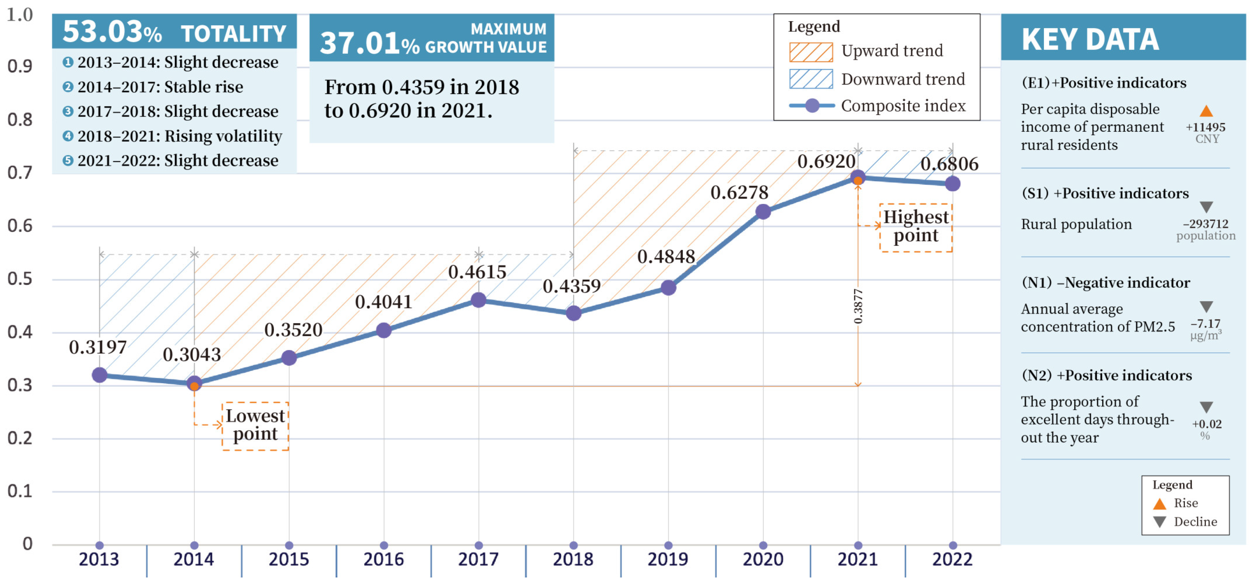
Over the ten-year period from 2013 to 2022, the RHES in the Emblem area shows a significant growth trend. Specifically, this composite index gradually increased from 0.3197 in 2013 to 0.6806 in 2022 (Figure 5). This reflects the continuous improvement of the region in terms of rural habitat.
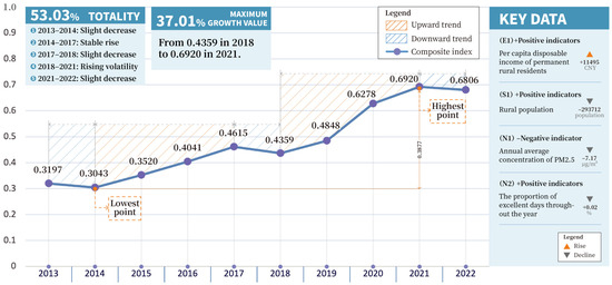
Figure 5.
A composite index for the Huizhou region from 2013 to 2022.
Overall, the status of the RHES in Huizhou has experienced a fluctuating upward trend and a slight decline in some periods. The trend of change can be subdivided into five main stages, each reflecting different development characteristics and challenges. In the next section, the research team will analyze these stages in detail, explore the influencing factors behind them, and assess how the corresponding policies and measures have contributed to the improvement of the RHES in Huizhou.
In 2013 and 2014, the Huizhou region experienced a slight decline in the Rural Habitat Environment Composite Index (RHES). This downward trend can be attributed to the relatively poor rural environmental infrastructure in the region. The challenge facing Huizhou region is determining how to improve the rural living environment while maintaining the traditional characteristics and features of the countryside. In order to meet this challenge, the local government and community workers have begun to work closely together, relying on the active participation of local residents, to jointly explore a model of good rural construction that is suitable for the Huizhou region.
From 2014 to 2017, the RHES in the Emblem region experienced a steady upward trend. During this period, the composite index increased, but the growth was relatively small. The growth in this phase reflects the effectiveness of the Huizhou region’s decision to incorporate the construction of a better countryside into key livelihood projects. The construction of a better countryside in the Huizhou region is also reflected in efforts to build harmonious urban–rural relations. Regional policy makers realized that there should be a complementarity and free flow of resources between urban and rural areas rather than simply transforming the countryside according to the urban model. Guided by this philosophy, Huizhou respects the respective functional positions of urban and rural areas and is committed to realizing the complementarity and overall coordination of urban and rural development.
In 2017 and 2018, the RHES in the Huizhou region experienced a small decline. During this phase, despite the decline in the composite index, this phenomenon also prompted the regions to start paying more attention to the protection and development of the rural environment. Realizing the importance of the rural environment, the Huizhou region began to take measures aimed at restoring and upgrading the quality of the rural habitat. This shift marks a new direction in regional policy and practice, one that places greater emphasis on sustainability and ecological balance.
From 2018 to 2021, the Rural Habitat Environment Composite Index (RHES) of the Huizhou region experienced a fluctuating upward phase. During this period, the Huizhou region placed agriculture and rural development at the forefront of policy planning and firmly implemented a new development concept centered on innovation, coordination, greenness, openness, and sharing. In order to enhance the overall development level of the countryside, the Huizhou region has made reference to the standards of the advanced regions in the Yangtze River Delta and has begun to explore the construction of an advanced demonstration area for rural revitalization.
In 2021 and 2022, there was a small decline in the RHES in Huizhou. This downward trend suggests the complexity of the rural spatial composition, including the mutual integration and harmonization of rural production space, living space, and ecological space [38,39]. At this stage, the Huizhou region faces the challenge of how to balance these three spatial types. To meet this challenge, the Huizhou region insists on the synchronized development of production, living, and ecology. Specifically, the Huizhou region has implemented a series of major ecological and environmental protection projects, taking the construction of a model area for ecological protection and compensation from Xin’anjiang River to Qiandao Lake as an opportunity. Through a variety of efforts, the Huizhou region continues to explore the development path of rural transformation and open up new ways to achieve rural economic development.
5.1.2. Typological Analysis of Different Regions
RHES conservation and socio-economic development are interlinked. The implementation of the RHES requires a large amount of financial investment, including infrastructure construction, environmental management, and agricultural development. The limited financial resources of villages are often unable to fulfill the requirements of comprehensive development, and this shortage of funds has become a major challenge. However, economic development should not be sacrificed for the RHES, and the construction of harmonious villages is more economically sustainable. The research team combined the economic levels of each area in Huizhou region and divided the zones into different latitudes. Including four kinds, high index–high economy, high index–low economy, low index–high economy, and low index–low economy. These divisions are based on the composite index and rural disposable income per capita. The delineation criteria are that a composite index greater than or equal to 0.4 is considered high ecological security, and a rural per capita disposable income GDP greater than or equal to 16,000 is considered a high economic level. Accordingly, the seven districts (counties) of the Huizhou region are distributed on the map (Figure 6).
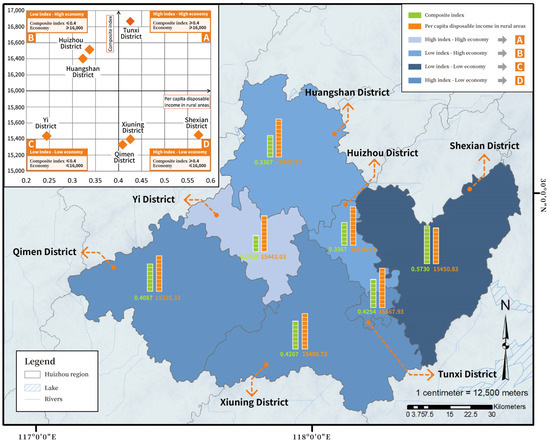
Figure 6.
Composite index for Huizhou region from 2013 to 2022.
According to the official website of the Huizhou region, the expert group derived the per capita disposable income of villagers in the Huizhou region (county) in the 2013–2022 period. The per capita disposable income of village inhabitants can be organized in the following order: Tunxi District (16,867.93), Huangshan District (16,406.23), Huizhou District (16,516.23), Shexian County (15,450.83), Xiuning County (15,400.73), Yixian County (15,443.03), and Qimen County (15,328.33). The results show that the Tunxi District belongs to the high index–high economy category. The Shexian, Xiuning, and Qimen counties belong to the high index–low economy category. Huizhou District and Huangshan District belong to the low index–high economy category. Yixian County belongs to the low index–low economy category.
5.1.3. Composite Index for Different Regions
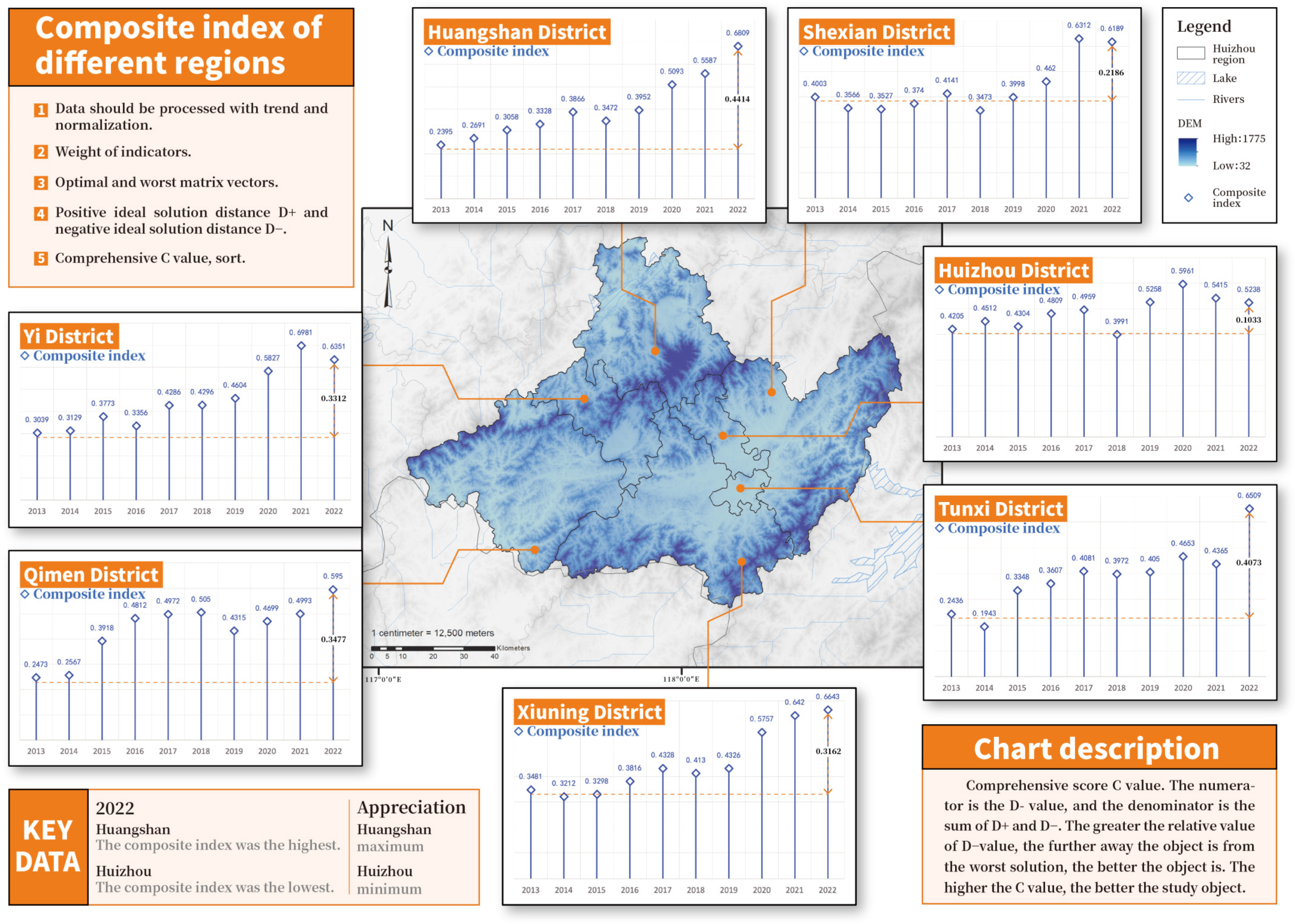
For a more detailed description of the RHES, the composite index of each district in Huizhou was calculated from 2013 to 2022 (Figure 7). Each area (county) showed an increasing trend, and the best RHES conditions were found in Huangshan District based on the following order: Huangshan District (0.2395–0.6809), Huizhou District (0.4205–0.5238), Tunxi District (0.2436–0.1943), Yixian County (0.3039–0.6351), Shexian County (0.4003–0.6189), Qimen County (0.2473–0.5950), and Xiuning County (0.3481–0.6643). An analysis of the comparative vicinity and rank of Huizhou’s regions based on the 2013–2022 period is shown below.
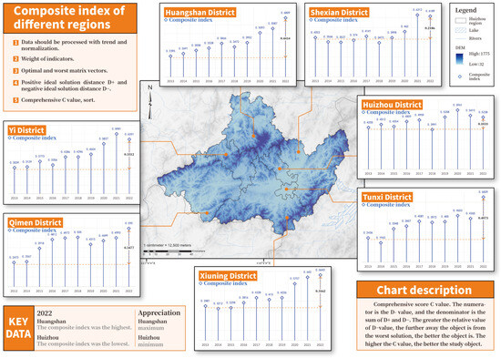
Figure 7.
Composite index for different regions.
First, the Huangshan District has the largest ten-year increase, with a difference of 0.4414. Moreover, the composite index for 2022 (0.6809) is the highest among all regions. In 1990, the region’s Huangshan Scenic Area was included in the World Heritage List. It is accelerating the promotion of world-class leisure and vacation destinations in Huangshan District and vigorously developing rural tourism. Meanwhile, Huangshan Maofeng and Taiping Houkui are known worldwide as Chinese tea varieties. The Huangshan District supports family farms and farmers’ cooperatives and accelerates the cultivation of rural specialty industries. Data from 2023 show that four villages in Huangshan District are on the list of Harmonious Countryside Boutique Demonstration Village Construction. They are the Tangjiazhuang Village in the Jiao Village Township, the Monkey Pit Village in the Xinming Township, the Shanqiao Village in the Tangkou Township, and the Ferry Village in the Longmen Township. Taking Xinming Township in Huangshan District as an example, the Xinming Village has clean and tidy village roads and increasingly perfect supporting facilities.
Second, the province with the greatest number of provinces sorted in the first place is Huizhou District. Huizhou District ranks first with overall indexes of 0.4205, 0.4512, 0.4304, 0.5258, and 0.5961 in 2013, 2014, 2015, 2019, and 2020, respectively. The main reason for this may be that Huizhou District has a forest coverage rate of 76.24%, and the Fengle River of the Xin’an River runs through the north and south, which gives it a good natural environment advantage. At the same time, Huizhou District has refined its construction, and now there are seven fine demonstration villages of the Hemei Countryside. Among them, there are three at the provincial level and four at the municipal level. However, since 2021, the RHES index of the Huizhou District has shown a decreasing trend. There are more than 300 ancient Huizhou-style buildings preserved in Huizhou District. Huizhou-style dwellings have the problems of summer heat and winter cold, especially the dilemma of high humidity, which aggravates the ecological pressure in Huizhou District. This suggests that developing an effective compensation mechanism for the residential environment in Huizhou District appears to be very necessary.
Third, Tunxi District and Shexian County rank relatively low on the composite index. The composite index of these two districts has been low in the time dimension. Although Tunxi District is not as rich and colorful as Huangshan District in terms of scenic spots, the local area possesses a profound history and culture. A total of 197 items of intangible cultural heritage exists in the district, covering a wide range of fields. Among them, the Cheng Da Bit bead algorithm has been awarded the list of Intangible Cultural Heritage of Humanity by UNESCO. Tunxi District should be evaluated based on local characteristics and regional features and adhere to cultural resources as a carrier, strengthening the integrated development of farming, culture, and transportation and cultivating new brands with influence. Second, the governance system in rural areas of Shexian is relatively weak, bringing obstacles. It is necessary to improve the basic supporting facilities and upgrade the levels of education, medicine, pension, culture, sports, and other public services.
5.2. Longitudinal Comparison between Years
By combining the data, the comprehensive score index of the Huizhou region was calculated for 2013, 2014, 2021, and 2022 (Figure 8). Using the ArcGIS software, the RHES index was divided into five levels. The overall state of the Huizhou region has been improved smoothly. Most of the districts (counties) have been improved, and the Huangshan District has the best status. As before, Huangshan District shows an upward trend, improving from 0.2558 to 0.3847. The rural conditions of the Qimen and Huining counties in 2022 have declined since 2013. Rural areas face problems of low quality and insufficient resources. The remaining five districts (counties) gradually improved. Therefore, the Qimen and Xiuning counties should strengthen their rural resource management, improve their levels of rural operation, and effectively supplement ecological resources.
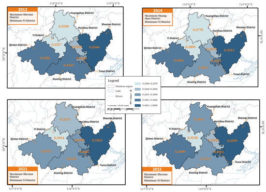
Figure 8.
Spatial distribution of RHES in Huizhou in 2013–2022 period.
First, Yixian County’s per capita disposable income (E1) rankings for rural residents are of the “low index–low economy” double-low type. On the economic front, the rising prices of agricultural fertilizers and seeds have increased the cost of agricultural production and dampened farmers’ incentive to grow food. In the social aspect, most of the young people in the countryside go out to work, and the labor force at home for farming is weak. Expanding production and quality improvement are difficult to realize. In terms of natural ecology, the strong development of the lodging industry and the dilution of the concept of environmental protection by most operators of ecological protection have brought potential damage to the ecological environment of the villages.
Secondly, regarding the rankings of the disposable income per capita of rural residents (E1), Qimen County ranked back but belongs to the “high index–low economic” type according to their agricultural resource advantages and development status. The development of the green food industry is an essential way to transform the mode of agricultural growth and promote the county’s farmers to achieve sustained and rapid income growth. In summary, from 2013 to 2022, Huizhou’s regional economic integration increased significantly, but there remain variations among the regions (counties).
5.3. Comparison of Different Indicators Relative to Each Other
GRA is founded on the geometrical similarity between the evaluating units and the orthogonal and antithetical “ideal solutions”. The research team utilized GRA to rank the three criteria layers and 18 indicator correlations of the RHES in Huizhou. This helped them determine the extent of impact of each index on the study population (Figure 9).
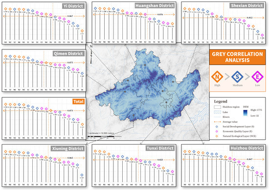
Figure 9.
Ranking of evaluation indicators based on level of impact.
According to the summary table for the Huizhou region, the factors with higher-than-average values on the regional RHES were mainly the natural ecosystem (NCE) and the social development system (S). The top five rankings of the degree of effect are, in descending order, N6 (0.993), N3 (0.991), N2 (0.989), S2 (0.988), and N5 (0.984). Among them, four indicators are out of the natural ecosystem. Realizing the abundance of rural industries and improving the rural ecological environment are the key ways to enhance the Huizhou region.
In recent years, the villages in the Huizhou region have seized the opportunity to tap their own characteristic elements and strengthen creative planning. At the same time, they continued to enrich the product industry and innovate the product system, and they have transformed the beautiful scenery into a beautiful economy. Located in the south of China’s Anhui Province, the Huizhou region is an area full of historical flavor and natural beauty. It not only has deep cultural heritage, but also many natural landscapes that attract tourists. Huangshan Mountain, one of the ten most famous mountains in China, is famous for its stunning scenery. It is both majestic and magnificent, as well as delicate and soft. Hongcun, known as “the countryside in Chinese paintings”, is famous for its unique Huizhou architecture and beautiful natural scenery. Hongcun, known as the countryside in Chinese painting, is famous for its unique Huizhou architecture and beautiful natural scenery.
6. Discussion
In the assessment of the carrying level, the RHES status of the Huizhou region shows a slight downward trend after a fluctuating increase. Overall, the RHES development level from 2013 to 2022 can be specifically categorized into five stages: small decline stage (2013 to 2014), stable rise stage (2014 to 2017), small decline stage (2017 to 2018), fluctuating rise stage (2018 to 2021), and small decline stage (2021 to 2022). At the local level, the seven districts (counties) are categorized into four types based on the composite index and rural disposable income per capita. Tunxi District belongs to the high index–high economy category. The Shexian, Xiuning, and Qimen counties belong to the high index–low economy category. Huizhou District and Huangshan District belong to the low index–high economy category. Yixian County belongs to the low index–low economy category.
Through an in-depth analysis of the composite indices of different regions, this study found that the RHES of all districts (counties) showed an upward trend, with Huangshan District’s performance being particularly outstanding. This achievement is attributed to the fact that Huangshan District has taken the creation of the National Rural Revitalization Demonstration County as an opportunity to strengthen systematic planning. Analyzed from a time-series perspective, the overall RHES status of the Huizhou region shows a steady upward trend. Although most of the districts (counties) have made progress, Tunxi District and Shexian County are still deficient in the RHES. This study not only emphasizes the excellent practice of Huangshan District in China’s rural construction, but also points out the deficiencies in infrastructure in other districts (counties), thus providing specific policy recommendations for rural revitalization in Huizhou. These findings fit with the national rural revitalization strategy and provide lessons to be learned for other regions.
Among the effector associations, the natural ecosystem (NCE) was the most dominant effector in Huizhou. N6 (0.993), N3 (0.991), and N2 (0.989) played strong roles in influencing the RHES in Huizhou. Similar studies have found that natural factors influence changes in the countryside [40]. In addition, according to the degree of impact of the evaluation indicators in Figure 9, the average value of each research object in the Huizhou region is above 0.8. Overall, this study reveals that the enhancement of the RHES in the Huizhou region requires more than surface-level improvements and should delve deeper into the level of cultural and historical heritage preservation. This study emphasizes the importance of whole-village preservation and the development of traditional villages, which not only echoes China’s national policy on cultural heritage preservation but also provides a viable model for other regions with similar historical backgrounds.
7. Conclusions
The RHES is an integral part of the urban–rural composite HES system and a synthesis of human–land relations in the countryside. This refers to the function of maintaining the integral blend of physical and non-physical structures required for the activities of village dwellers. Based on the composite ecosystem–SENCE conceptual framework, the research team explored the degree of relevance of the indicators through a comprehensive assessment of the Huizhou region for the period of 2012–2021. The complexity and uncertainty of the RHES system were considered to make the assessment results more science-based and rational. Taking seven districts (counties) in Huizhou region as the research objects, entropy weight TOPSIS was applied and combined with GRA to judge the key effect factors. The results can offer a decision-making basis for the stable use and science-based administration of rural renewable energy systems and to promote the stable development of rural integration.
(1) Harmonious villages are villages with “livable” environments and basically modern living conditions. At present, the rural society in Huizhou is in a period of profound change and adjustment. The level of basic living facilities and public services in rural areas has been continuously upgraded. Rural roads and logistics and other infrastructure are complete. The level of public services, for example, education, health care, and pensions, is close to that of the cities. Some rural areas have experienced some decline. The trend of population aging is obvious, and the hollowing out phenomenon also exists, to a certain extent, in the countryside. Considering the development patterns of different types of villages, the focus is on upgrading the shortcomings of inadequate infrastructure and public services in accordance with local conditions.
(2) Harmonious villages are villages in which development is “workable”. We innovated the operation system for utilizing the resources of traditional villages and are actively exploring the operation mechanism of “one platform management, multiple main body operation” for building, sharing, and enrichment. Xidi and Hongcun adopted a differentiated development strategy relying on the richness of ancient residential resources and preserving the work of the villages. The village’s layout allows for a variety of experiential, interactive activities that can benefit the tourism industry, and sightseeing is free of charge. For example, the Huimo Ink Production Experience Center was built and put into operation. It attracts more than 30,000 researchers every year. It actively mobilizes rural agricultural workers to seek employment and entrepreneurship in their hometowns, attracting nearly 100 people to return to their hometowns to engage in catering, tourism, construction, and other service industries.
(3) Harmonious villages are villages that live “harmoniously” and have a stable and harmonious social environment. Villages integrate production, living, and ecological functions and have distinctive village styles. They need to be developed based on the regional characteristics of the countryside and be integrated with the natural ecology. They must also adhere to the strictest ecological protection system with the goal of improving the ecological security pattern; consider industrial development, population layout, public services, land use, and ecological protection in an integrated manner; plan the spatial distribution and building of agricultural production and living facilities in a scientific and rational manner; preserve outstanding traditional vernacular culture; and promote the integration and development of traditional vernacular culture with modern civilization.
This study provides an in-depth assessment of the RHES in Huizhou by analyzing the HSE index. However, well-being is a multidimensional concept, and its comprehensive assessment needs to consider a wider range of factors. Although this study involves the natural ecosystem subsystem (NCE), it still has shortcomings. Future work will explore the effects of biodiversity and cultural identity on the well-being of residents and determine how rural residential environments can be enhanced through the protection and enhancement of native ecosystems. These factors will be incorporated into rural development strategies as recommended by the United Nations Convention on Biological Diversity (CBD).
Author Contributions
Conceptualization, Yanlong Guo and Xingmeng Ma; methodology, Xin Su and Linfu Zhang; software, Xingmeng Ma; validation, Xingmeng Ma and Yanlong Guo; formal analysis, Yanlong Guo; investigation, Xin Su and Yanlong Guo; resources, Yanlong Guo; data curation, Linfu Zhang; writing—original draft preparation, Yanlong Guo and Xingmeng Ma; writing—review, Yanlong Guo; editing, Linfu Zhang; visualization, Xingmeng Ma; supervision, Yanlong Guo; project administration, Yanlong Guo. All authors have read and agreed to the published version of the manuscript.
Funding
This study obtained the research topic of Anhui Province’s social science innovation and development from the study titled “Study on the Driving factors of living and Working Conditions in Huizhou Area and the American Countryside” (2023CX137) and the study by the Huizhou Ancient Village Digital Protection and Inheritance of Creativity, Anhui Province Key Laboratory, titled “Huizhou Ancient Village Digital creative Product Design under the Background of Cultural and Tourism Integration” (PA2023GDSK0118). This study was also supported by the Anhui Provincial Research Planning Project titled “Research on Living Conservation Mode of Huizhou Cultural and Ecological Protection Area” (2022AH050038).
Data Availability Statement
The experimental data used to support the findings of this study are included in the article.
Conflicts of Interest
The authors declare no conflicts of interest.
References
- Wang, Y.; Zhu, Y. Exploring the Effects of Rural Human Settlement on Rural Development: Evidence from Xianju County in Zhejiang Province, China. Environ. Dev. 2023, 16, 100845. [Google Scholar] [CrossRef]
- Zhang, T.; He, D.; Kuang, T.; Chen, K. Effect of Rural Human Settlement Environment around Nature Reserves on Farmers’ Well-Being: A Field Survey Based on 1002 Farmer Households around Six Nature Reserves in China. Int. J. Environ. Res. Public Health 2022, 19, 6447. [Google Scholar] [CrossRef]
- Dou, H.; Ma, L.; Li, H.; Bo, J.; Fang, F. Impact Evaluation and Driving Type Identification of Human Factors on Rural Human Settlement Environment: Taking Gansu Province, China as an Example. Open Geosci. 2020, 12, 1324–1337. [Google Scholar] [CrossRef]
- Sanchez, T.W.; Ye, X. The Implications of Human Mobility and Accessibility for Transportation and Livable Cities. Urban Sci. 2023, 7, 107. [Google Scholar] [CrossRef]
- Zhang, H.; Cong, R.; Luan, S. Utilization Quality Evaluation and Barrier Factor Diagnosis of Rural Residential Areas in Agricultural Regions of the Northeast Plain: A Case Study of Wangkui County, Heilongjiang Province, China. Land 2023, 12, 870. [Google Scholar] [CrossRef]
- Yan, Z.; Peng, L.; Wu, X. Evaluation System for Agricultural and Rural Modernization in China. Agriculture 2023, 13, 1930. [Google Scholar] [CrossRef]
- Santilli, S.; Valbusa, I.; Rinaldi, B.; Ginevra, M.C. Life Satisfaction, Courage, and Career Adaptability in a Group of Italian Workers. Soc. Sci. 2024, 13, 106. [Google Scholar] [CrossRef]
- Yao, Q.; An, N.; Gu, G.; Yang, E.; Yang, H.; Li, C.; Yan, K. Research Progress on Features and Characteristics of Rural Settlements: Literature Distribution, Key Issues, and Development Trends. Buildings 2023, 13, 2457. [Google Scholar] [CrossRef]
- Hidalgo-Fuentes, S.; Martínez-Álvarez, I.; Sospedra-Baeza, M.J.; Martí-Vilar, M.; Merino-Soto, C.; Toledano-Toledano, F. Emotional Intelligence and Perceived Social Support: Its Relationship with Subjective Well-Being. Healthcare 2024, 12, 634. [Google Scholar] [CrossRef]
- Han, Y.; Huang, J. Evolution of Social Welfare in Rural China: A Developmental Approach. Int. Soc. Work 2019, 62, 390–404. [Google Scholar] [CrossRef]
- Jiang, S.; Ma, H.; Yang, L.; Luo, S. The Influence of Perceived Physical and Aesthetic Quality of Rural Settlements on Tourists’ Preferences—A Case Study of Zhaoxing Dong Village. Land 2023, 12, 1542. [Google Scholar] [CrossRef]
- Beltramo, R.; Peira, G.; Pasino, G.; Bonadonna, A. Quality of Life in Rural Areas: A Set of Indicators for Improving Wellbeing. Sustainability 2024, 16, 1804. [Google Scholar] [CrossRef]
- Zhou, F.; Guo, X.; Liu, C.; Ma, Q.; Guo, S. Analysis on the Influencing Factors of Rural Infrastructure in China. Agriculture 2023, 13, 986. [Google Scholar] [CrossRef]
- Shi, B.; Liu, H.; Huang, L.; Zhang, Y.; Xiang, Z. Increasing Vulnerability of Village Heritage: Evidence from 123 Villages in Aba Prefecture, Sichuan, China. Land 2023, 12, 2048. [Google Scholar] [CrossRef]
- Simandan, D. Being Surprised and Surprising Ourselves: A Geography of Personal and Social Change: A Geography of Personal and Social Change. Prog. Hum. Geogr. 2020, 44, 99–118. [Google Scholar] [CrossRef] [PubMed]
- Smith, T.S.J.; Reid, L. Which ‘Being’ in Wellbeing? Ontology, Wellness and the Geographies of Happiness. Prog. Hum. Geogr. 2018, 42, 807–829. [Google Scholar] [CrossRef]
- Welch-White, V.; Langan, R. Co-Ops Advocate for Rural Infrastructure: At Capitol Hearing, Co-Op Leaders Address Critical Need for Modern Infrastructure. N. Y. For. Own. 2017, 55, 12–17. [Google Scholar]
- Wang, Y.; Zhao, Z.; Xu, M.; Tan, Z.; Han, J.; Zhang, L.; Chen, S. Agriculture–Tourism Integration’s Impact on Agricultural Green Productivity in China. Agriculture 2023, 13, 1941. [Google Scholar] [CrossRef]
- Bigiotti, S.; Costantino, C.; Marucci, A. Agritourism Facilities in the Era of the Green Economy: A Combined Energy Audit and Life Cycle Assessment Approach for the Sustainable Regeneration of Rural Structures. Energies 2024, 17, 1101. [Google Scholar] [CrossRef]
- Yang, Y.; Wang, K.; Zhou, D.; Wang, Y.; Zhang, Q.; Xu, D. Improvement of Human Comfort in Rural Cave Dwellings via Sunrooms in Cold Regions of China. Buildings 2024, 14, 734. [Google Scholar] [CrossRef]
- Meng, J.; Yang, L.; Lei, H. Promoting Elderly Care Sustainability by Smart Village Facilities Integration—Construction of a Public Service Field with Introduction of Fall Posture Monitoring. Buildings 2023, 13, 2144. [Google Scholar] [CrossRef]
- Kuczman, G.; Bechera, D.; Rózová, Z.; Tóth, A. Roadside Vegetation Functions, Woody Plant Values, and Ecosystem Services in Rural Streetscapes: A Qualitative Study on Rural Settlements in Western Slovakia. Land 2024, 13, 272. [Google Scholar] [CrossRef]
- Zuo, Y.; Yang, C.; Xin, G.; Wu, Y.; Chen, R. Driving Mechanism of Comprehensive Land Consolidation on Urban–Rural Development Elements Integration. Land 2023, 12, 2037. [Google Scholar] [CrossRef]
- Dai, X.; Zhang, J.; Sun, X.; Li, J.; Liu, B. Differentiation Governance of Rural Human Settlement Environments in China: Knowledge Mapping and Visualization. Int. J. Environ. Res. Public Health 2023, 20, 4209. [Google Scholar] [CrossRef] [PubMed]
- Hu, Q.; Wang, C. Quality Evaluation and Division of Regional Types of Rural Human Settlements in China. Habitat Int. 2020, 105, 102278. [Google Scholar] [CrossRef]
- Tong, S.; Zhu, Y.; Li, Z. Correlation Study between Rural Human Settlement Health Factors: A Case Study of Xiangxi, China. Comput. Intell. Neurosci. 2022, 2022, 2484850. [Google Scholar] [CrossRef] [PubMed]
- Bian, D.; Yang, X.; Wu, F.; Babuna, P.; Luo, Y.; Wang, B.; Chen, Y. A Three-Stage Hybrid Model Investigating Regional Evaluation, Pattern Analysis and Obstruction Factor Analysis for Water Resource Spatial Equilibrium in China. J. Clean. Prod. 2022, 331, 129940. [Google Scholar] [CrossRef]
- Zhu, S.; Feng, H.; Shao, Q. Evaluating Urban Flood Resilience within the Social-Economic-Natural Complex Ecosystem: A Case Study of Cities in the Yangtze River Delta. Land 2023, 12, 1200. [Google Scholar] [CrossRef]
- Tai, X.; Xiao, W.; Tang, Y. A Quantitative Assessment of Vulnerability Using Social-Economic-Natural Compound Ecosystem Framework in Coal Mining Cities. J. Clean. Prod. 2020, 258, 120969. [Google Scholar] [CrossRef]
- Jin, C.; Guan, Q.; Gong, L.; Zhou, Y.; Ji, Z. Evaluation of Regional Water Environmental Carrying Capacity and Diagnosis of Obstacle Factors Based on UMT Model. Water 2022, 14, 2621. [Google Scholar] [CrossRef]
- Pan, Y.; An, Z.; Wang, J.; Weng, G. Dynamic Evolution Characteristics and Drivers of Tourism-Related Ecological Security in the Beijing–Tianjin–Hebei Region. Systems 2023, 11, 533. [Google Scholar] [CrossRef]
- Zhao, H.; Li, J. Energy Efficiency Evaluation and Optimization of Industrial Park Customers Based on PSR Model and Improved Grey-TOPSIS Method. IEEE Access 2021, 9, 76423–76432. [Google Scholar] [CrossRef]
- Zhang, Y.; Zhang, J.; Li, Y.; Liang, S.; Chen, W.; Dai, Y. Revealing the Spatial-Temporal Evolution and Obstacles of Ecological Security in the Xiamen-Zhangzhou-Quanzhou Region, China. Land 2024, 13, 339. [Google Scholar] [CrossRef]
- Wei, H.; Gao, Y.; Han, Q.; Li, L.; Dong, X.; Liu, M.; Meng, Q. Quality Evaluation and Obstacle Identification of Human Settlements in the Qinghai–Tibet Plateau Based on Multi-Source Data. Land 2022, 11, 1479. [Google Scholar] [CrossRef]
- Lin, S.; Hou, L. SDGs-Oriented Evaluation of the Sustainability of Rural Human Settlement Environment in Zhejiang, China. Heliyon 2023, 9, e13492. [Google Scholar] [CrossRef] [PubMed]
- Rehman, A.U.; AlFaify, A.Y. Evaluating Industry 4.0 Manufacturing Configurations: An Entropy-Based Grey Relational Analysis Approach. Processes 2023, 11, 3151. [Google Scholar] [CrossRef]
- Chen, Z.; Zhang, C.; Raza, S.T. Evaluation of Forest Ecological Security and Its Influencing Factors in Multi-Climatic Zones: A Case Study of Yunnan Province. Appl. Sci. 2023, 13, 12345. [Google Scholar] [CrossRef]
- Bi, G.; Yang, Q. Spatial Reconstruction of Rural Settlements Based on Multidimensional Suitability: A Case Study of Pingba Village, China. Land 2022, 11, 1299. [Google Scholar] [CrossRef]
- Zhang, Z.; Fang, B.; Li, X.; Wang, Y. Evaluation of Human Settlement Environment and Identification of Development Barriers Based on the Ecological Niche Theory: A Case Study of Northern Shaanxi, China. Int. J. Environ. Res. Public Health 2023, 20, 1772. [Google Scholar] [CrossRef]
- Yu, L.; Xie, D.; Xu, X. Environmental Suitability Evaluation for Human Settlements of Rural Residential Areas in Hengshui, Hebei Province. Land 2022, 11, 2112. [Google Scholar] [CrossRef]


Disclaimer/Publisher’s Note: The statements, opinions and data contained in all publications are solely those of the individual author(s) and contributor(s) and not of MDPI and/or the editor(s). MDPI and/or the editor(s) disclaim responsibility for any injury to people or property resulting from any ideas, methods, instructions or products referred to in the content. |
© 2024 by the authors. Licensee MDPI, Basel, Switzerland. This article is an open access article distributed under the terms and conditions of the Creative Commons Attribution (CC BY) license (https://creativecommons.org/licenses/by/4.0/).